
 California Highways:
Click here for a key to the symbols used. An explanation of acronyms may be found at the bottom of the page.
 Routing
 From Route 99 near Tipton to Route 127 near Death Valley Junction via the vicinity of
Porterville, Camp Nelson, Olancha, and Death Valley.
From Route 99 near Tipton to Route 127 near Death Valley Junction via the vicinity of
Porterville, Camp Nelson, Olancha, and Death Valley.
 Post 1964 Signage History
This route is as defined in 1963. The 47 mi of this route between Quaking Aspen to Haiwee Pass, was adopted in late 1965. This is the segment over the Sierras, from Quaking Aspen Campground to near US 395 near Haiwee Cyn Road. It has never been constructed. The remainder of this route (from Route 99 to Quaking Aspen Campground, and from US 395 near Haiwee Cyn Road to Route 127 near Death Valley Junction is conventional highway. There is some additional discussion on the page for County Sign Route J37. There is a good discussion on the unconstructed segment on the Gribblenation Blog.
Route 190 was originally routed through downtown Porterville from Poplar
Avenue on a multiplex of Route 65 on Main Street. Route 190 continued east
through Porterville on Orange Avenue, Date Avenue, and Springville Avenue.
Route 190 was realigned onto the modern expressway alignment in sections
from 1960 to 1964 as part of the Lake Success Project. The Success Dam
impounds the Tule River and was built from 1958 to 1961. The primary
purpose of the Success Dam was flood control down river in Porterville.
The Tule River is one of many watersheds that used to flow into Tulare
Lake to the west in San Joaquin Valley. Route 190 used to be routed
through the northern half of Lake Success. There was a small community
known as Success which was a rail siding of the Southern Pacific Line
between Porterville and Springville. Success also had a small rock quarry
which is located immediately east of Lake Success. Route 190 originally
would have emerged from Lake Success where Holdridge Drive now dips into
the waters. Route 190 ran eastward on Avenue 176 and Road 320 on what is
now County Sign Route J28 to modern Route 190.
(Source: Gribblenation Blog, California State Route 190; a Trans-Sierra Highway that could have been, 8/17/2018)
Around 1958, the work to relocate the route at Lake Success began. The
relocation of Route 190/LRN 127 from Hospital Road to Worth Road was
funded in FY59; the new realingment was west of the future Success
Reservoir. The September/October 1958 California Highways &
Public Works noted in a District VI report that 7 miles of Route 190/LRN 127 was to be relocated east of Porterville to make way for the Success
Reservoir. The relocation of Route 190/LRN 127 through the Success
Reservoir site is stated to be funded by the Federal Government at a cost
of $1,700,000 and was anticipated to be completed by Fall 1958. By 1960
the realignment was completed. The Army Corps of Engineers completed the
Success Reservoir in 1961, which flooded over much of the original
alignment of Route 190/LRN 127 via the waters of Lake Success.
(Source: Gribblenation Blog (Tom Fearer), "Former California State Route 190 at the bottom of Lake Success", October 2021)
Note that, in 1964, the actual routing was changed. The old routing from Lone Pine E became Route 136, and a new routing over the Sierras that would end in Olancha was explored (and thus, unconstructed Route 190 was changed to go through Olancha instead of Lone Pine).
 Pre 1964 Signage History
In 1934, Route 190 was signed along the route from Jct. US 99 at Tipton to Death Valley Junction via Lone Pine. This route was LRN 127, defined in 1933.
In 1926, however, the LA Times reported that:
...a million-dollar road running to the "Roof of the United States," with a lateral to Mt. Whitney, the highest point in the United States, will be ready for service to motorists [shortly], according to definite plans which have been drafted by State, county and city officials. The new road, which is to run from Lone Pine in the Owens Valley, up into the high Sierras through Carroll Creek and over Mulky Pass, going westward to the heart of the Kern River country, will have three western terminals; Porterville, Visalia and Bakersfield. The road from Lone Pine to Porterville will be 115 miles long. It is to be a dirt road, twelve feet wide. The highest altitude of the main artery will be 11,300 feet at Mulky Pass, 1359 feet higher than Tioga Pass.
The article went on to note that "With the aid of the city of Los
Angeles, Inyo county is expected to build the road to the county line at
Mulky Pass, starting from Carroll Creek. This unit alone will cost
$170,000. Of the total cost to fall on the three counties involved Kern
and Tulare are each to pay 45 percent and Inyo county 10 percent. Inyo's
percentage is low because it has only about $10,000,000 in taxable
property." The article went on to note: "The new Lone Pine-Porterville
road will enter the Sequoia National Park only at the southeast corner of
the old park boundaries, entering near the rangers' station at Quinn's
Horse-camp, and coming out again at the north fork of the Middle Fork
River and entering Balch Park. this unit of the road will run to Milo,
where the present road goes westward to Exeter and Visalia. The other
road, from Balch Park to Porterville, is already in use. the third unit of
the western connections will bear off the main road to be built at
Deadman's Canyon the Kern River, about at the halfway point, and will
follow the north fork to meet the present road at Fairview." Note that
Balch Park Road is what is now County Sign Route J37.
(Source: Owens Valley History Website)
Tom Fearer, in his Gribblenation blog entry, has a detailed analysis of later proposals to cross the Sierras. Refer there for maps and full details; this is a
summary. There have been three proposed routes of Route 190 through the
Sierras, all involving traversing the Kern Canyon Fault. The first
proposed routing through the Sierras was from Quaking Aspen northeast to
Lone Point and is the one that came the closest to actually being built.
This first appears on the 1934 State Highway Map, at the time the road
east out of Camp Nelson was not state maintained as was Tuttle Creek Road
west out of Lone Pine through the Alabama Hills. That changed by 1935. At
the same time the Division of Highways assumed maintenance of Tuttle Creek
Road west out of Lone Pine to Carroll Creek. By 1938, the state map shows
Route 190 on Tuttle Creek Road heading southwest out of Lone Pine. and by
1940, it was extended from Tuttle Creek Road westward up what is now the
first bend in Horseshoe Meadows Road into the Sierras. On the eastern side
of the Sierras, Route 190 used Horseshoe Meadows Road, Tuttle Creek Road,
and Whitney Portal Road to reach US 395 in Lone Pine. Today part of Tuttle
Creek Road is abandoned and has been replaced by extended Horseshoe
Meadows Road. Horseshoe Meadows Road is explored in great detail in the
blog "Horseshoe Meadows Road; former California State Route 190 and the legacy of the Lone Pine-Porterville High Sierra Road". Tom's blog has maps showing all of this. By 1960 the Horseshoe Meadows Road and Tuttle Creek
alignment of Route 190 was relinquished and a new proposed routing over
Olancha Pass appears on the State Highway Map. By 1966 the third and final
proposed routing of Route 190 over Haiwee Pass appears on the State
Highway Map. The old routing of Route 190 to Lone Pine is shown as LRN 136. Again, consult the linked blog for more details.
(Source: Gribblenation California State Route 190; a Trans-Sierra Highway that could have been, 8/17/2018)
 Status
Unconstructed Portion
 Unconstructed from Quaking Aspen to Route 395
on a route adopted 10/20/1965. Portions of the route were adopted as a
conventional highway on 4/15/1964. Rescinding the route was recommended on
6/25/1982, but nothing ever happened. District 9 recommends deletion of
the route.
Unconstructed from Quaking Aspen to Route 395
on a route adopted 10/20/1965. Portions of the route were adopted as a
conventional highway on 4/15/1964. Rescinding the route was recommended on
6/25/1982, but nothing ever happened. District 9 recommends deletion of
the route.
The 2013 Traversable Highways report notes:
One 1953 map shows the routing between Wonoga Peak and Lone Pine as what is now Horseshoe Meadows Road, Tuttle Creek Road, and Whitney Portal Road. The map implies that the Route 136 routing was used, but doesn't make it explicit. According to the Traversable Highways report, there are no local roads that adequately fit the description of a traversable highway. This is mountainous terrain. There are no plans to construct this.
In June 2017, the CTC approved the following SHOPP allocation: Tulare 06-Tul-190 0.0/8.0 $16,900,000 Route 190: Tulare County, from west of Route 99/Route 190 Separation to west of Road 184. Outcome/Output: Rehabilitate deteriorating pavement and realign new traveled way and shoulders to meet current standards. The project is necessary to improve safety and ride quality. Future consideration of funding approved under Resolution E-13-61; August 2013.
In October 2021, the CTC authorized relinquishment of right-of-way,
consisting of collateral facilities (5 segments), in the county of Tulare
along Route 190 at Road 120 and Road 152 (06-Tul-190-PM 0.39/4.45).
The City, by Resolution No. 2021-0604 dated July 27, 2021, agreed to waive
the 90-day notice requirement and accept title upon relinquishment by the
State.
(Source: October 2021 CTC Agenda, Agenda Item 2.3c)
Route 190/Road 152 Roundabout E of Tipton (~ TUL 4.465)
 Caltrans is exploring creating a roundabout on this route
at the intersection of Route 190/Road 152 (Bliss Lane) east of Tipton.
Other potential/planned roundabout locations in the San Joaquin Valley
include Route 145/Jensen near Kerman, Route 168/Auberry Road in Prather,
Route 43/Route 137 in Corcoran, Route 216/Route 245 in Woodlake, Route 190/Road 284 east of Porterville, and Route 155/Browning Road in Delano. A
2007 study of 55 roundabouts in the U.S. found a 35% reduction in
accidents and a 90% reduction in fatal accidents when intersections with
stop signs or signals were converted to roundabouts. It costs about the
same to build a roundabout as to put up traffic signals, and they need
significantly less maintenance than traffic signal intersections -- about
60% to 90% less, depending on how much landscaping work is required.
Caltrans is exploring creating a roundabout on this route
at the intersection of Route 190/Road 152 (Bliss Lane) east of Tipton.
Other potential/planned roundabout locations in the San Joaquin Valley
include Route 145/Jensen near Kerman, Route 168/Auberry Road in Prather,
Route 43/Route 137 in Corcoran, Route 216/Route 245 in Woodlake, Route 190/Road 284 east of Porterville, and Route 155/Browning Road in Delano. A
2007 study of 55 roundabouts in the U.S. found a 35% reduction in
accidents and a 90% reduction in fatal accidents when intersections with
stop signs or signals were converted to roundabouts. It costs about the
same to build a roundabout as to put up traffic signals, and they need
significantly less maintenance than traffic signal intersections -- about
60% to 90% less, depending on how much landscaping work is required.
In December 2014, the CTC approved for future consideration of funding a project that will construct a roundabout at the intersection of Route 190 (Avenue 144) and Road 152 (Bliss Lane, Tulare County Sign Route J15). The project is programmed in the 2014 State Highway Operation and Protection Program. The total estimated cost is $6,333,000 for capital and support. Construction is estimated to begin in Fiscal Year 2016-17. The scope, as described for the preferred alternative, is consistent with the project scope programmed by the Commission in the 2014 State Highway Operation and Protection Program.
In August 2016, the CTC approved $3,290,000 in funding for Route 190 near Tipton, from 0.4 mile west of Road 152 to 0.7 mile west of Road 160. Outcome/Output: Construct roundabout, sidewalk, curb and gutter and reconstruct 1.0 mile of Route 190 and 0.5 mile of Road 152 to increase safety and reduce the number and severity of collisions.
In May 2017, it was reported that work was expected to
begin this month on the second roundabout on Route 190. That roundabout
will be constructed at Route 190 and Road 152 and work on that $2.2
million project will take about four to six months and preclude
improvements to the highway all the way to Route 99. It was at that busy
rural intersection which three people died in a horrific crash on Aug. 2,
2011. Two of those killed were teenagers in a Tulare County probation van,
while the third was the driver of a large pickup which apparently ran the
stop sign and drove into the path of the van which was eastbound on Route 190.
(Source: Recorder Online, 5/8/2017)
Rockford Road Roundabout (06-Tulare-190 PM 11.3/11.5)
In March 2020, the CTC amended the following project
into the 2018 SHOPP: 06-Tul-190 11.3/11.5 PPNO 7033 ProjID 0619000232 EA
1A310 Route 190 near Porterville from 0.1 mi W to 0.1 mi E of Rockford
Road. Construct roundabout. Total cost: $10,100K. BC 3/30/2024.
Construction and R/W acquisition not yet programmed. The CTC also approved
the following financial allocation: 06-Tul-190 PM 11.3/11.5. PPNO 7033.
ProjID 0619000232. EA 1A310. Route 190 near Porterville, from 0.1 mile
west to 0.1 mile east of Rockford Road. Construct roundabout. (Concurrent
Amendment under SHOPP Amendment 18H-015; March 2020.) Financial
allocation: PA&ED $1,400,000
(Source: March 2020 CTC Agenda, Agenda Item
2.1a.(1a) #24, 2.5b.(2a) #19)
The 2020 SHOPP, approved in May 2020, included the
following Collision Reduction item of interest (carried over from the 2018
SHOPP): 06-Tulare-190 PM 11.3/11.5 PPNO 7033 Proj ID 0619000232 EA 1A310.
Route 190 near Porterville, from 0.1 mile west to 0.1 mile east of
Rockford Road. Construct roundabout. Programmed in FY23-24, with
construction scheduled to start at the end of March 2024. Total project
cost is $10,100K, with $4,950K being capital (const and right of way) and
$5,150K being support (engineering, environmental, etc.).
(Source: 2020 Approved SHOPP a/o May 2020)
In March 2022, the CTC approved for future
consideration of funding 06-Tul-190, PM 11.31/11.51. PPNO 7033. Rockford
Road Roundabout. Construct a roundabout at the intersection of
Route 190 at Rockford Road in Tulare County.The project is located on
Route 190 from postmile 11.31 to 11.51, in Tulare County. The proposed
project would construction a single-lane roundabout at the intersection of
Rockford Road and Route 190 in Porterville. This project is
currently programmed in the 2020 SHOPP for a total of $8,700,000 which
includes Plans, Specifications and Estimate, Right of Way (capital and
support), and Construction (capital and support). Construction is
estimated to begin in 2023-24. The scope, as described for the preferred
alternative, is consistent with the project scope as programmed by the
Commission in the 2020 SHOPP.
(Source: March 2022 CTC Agenda, Agenda Item
2.2c.(1))
Also in March 2022, the CTC approved the following
pre-construction financial allocation: 06-Tul-190 11.3/11.5. PPNO 06-7033;
ProjID 0619000232; EA 1A310. Route 190 Near Porterville, from 0.1 mile
west to 0.1 mile east of Rockford Road. Construct roundabout. (Concurrent
consideration of funding under Resolution E-22-15; March 2022.)
Allocation: PS&E $1,550,000; R/W Sup $850,000.
(Source: March 2022 CTC Agenda, Agenda Item
2.5b.(2a) #11)
In June 2023, the CTC amended the following project in
the 2022 SHOPP: 06-Tul-190 11.3/11.5. PPNO 06-7033; ProjID 0619000232; EA
1A310. Route 190 Near Porterville, from 0.1 mile west to 0.1 mile east of
Rockford Road. Construct roundabout. Note: Increase R/W capital because an
increase in acquisition and Title/Escrow fees. Increase construction
capital because of included installation of flashing beacons and lighting
at the roundabout. Allocation Changes ($ × 1,000): R/W Cap $750
$950; Const Cap $4,200 $4,441; Total $10,100
$10,541.
(Source: June 2023 CTC Agenda, Agenda Item 2.1a.(1d) #52)
In October 2023, the CTC approved for consideration of
funding the following project for which a Negative Declaration (ND) and an
Addendum have been completed: Route 190 in Tulare County. Construct a
single-lane roundabout at the intersection of Route 190 at Rockford Road,
in Tulare County. (06-Tul-190, PM 11.31/11.51; PPNO 7033). The project is
currently programmed in the 2022 SHOPP for a total of $10,541,000, which
includes Right of Way (Support and Capital) and Construction
(Support and Capital). Construction began in 2023-24. The scope, as
described for the preferred alternative, is consistent with the project
scope as programmed by the Commission in the 2022 SHOPP. A copy of the ND
has been provided to Commission staff. The Commission approved the project
for future consideration of funding on March 17, 2022, under Resolution
E-22-15. Since the approval of the ND, there have been changes to the
project and an Addendum was prepared pursuant to CEQA. These changes
include adjusting the project limits to account for the replacement of
existing flashing beacons, and thus the project limits have changed to SR
190, PM 11.2 to PM 11.6. The project changes do not meet the criteria
outlined in CEQA Guidelines Section 15162 to prepare a Subsequent ND. The
Department subsequently completed an Addendum to the ND pursuant to CEQA.
The Department has approved this project for construction. This approval
and the Addendum will satisfy the environmental requirements for this
stage of the planning process.
(Source: October 2023 CTC Agenda, Agenda Item 2.2c.(4))
Prospect Street to Porterville Improvements (~ TUL R14.956 to TUL 19.063)
 In October 2016, the CTC approved for future
consideration of funding a project in Tulare County that will construct
median barriers on Route 190 in the city of Porterville (between South
Prospect Street and the Eastern Porterville City Limits). The project is
programmed in the 2016 State Highway Operation and Protection Program. The
total programmed amount is $7,023,000 for capital and support.
Construction is estimated to begin in Fiscal Year 2017-18. The scope, as
described for the preferred alternative, is consistent with the project
scope programmed by the Commission in the 2016 State Highway Operation and
Protection Program.
In October 2016, the CTC approved for future
consideration of funding a project in Tulare County that will construct
median barriers on Route 190 in the city of Porterville (between South
Prospect Street and the Eastern Porterville City Limits). The project is
programmed in the 2016 State Highway Operation and Protection Program. The
total programmed amount is $7,023,000 for capital and support.
Construction is estimated to begin in Fiscal Year 2017-18. The scope, as
described for the preferred alternative, is consistent with the project
scope programmed by the Commission in the 2016 State Highway Operation and
Protection Program.
In May 2017, it was reported that the
Prospect-Porterville was about to start. This project will complete the
improvements made from Porterville to just past Poplar. Those improvements
include the installation of turn lanes, shoulder widening and new
pavement. That project is scheduled to begin in August or September 2017
and is expected to take more than a year and cost around $21 million.
(Source: Recorder Online, 5/8/2017)
In July 2018, it was reported that the median
construction project was continuing, with a series of detours near
Porterville College, The construction project to replace a mile-long
section of oleanders in the highway’s median with concrete barriers
and other upgrades has been going on since May 2018. The project, which
includes installation ofconcrete barriers in the median of Route 190 and
upgraded crash cushions on the Route 65 and Route 190 cloverleaf, is
expected to finish in October.
(Source: �� Recorder Online, 7/3/2018)
In January 2012, the CTC approved $5.75 million for an asphalt-overlay project on Route 190 in Tulare County near Lake Success. The upgrade fromthe Tule River Bridge (~ TUL 20.002) to Road 284 (~ TUL 21.1) will improve pavement quality and increase service life.
Route 190/Road 284 Roundabout (~ TUL 21.09)
In May 2012, it was reported that Caltrans was holding meetings on the intersection of Route 190 and Road 284. Two build alternatives and a no-build alternative are under consideration. The alternatives include a single-lane rural roundabout or a traffic signal with a protected left turn.
In April 2017, there was an update on the Route 190/Road 284 roundabout. The intersection is located in unincorporated
Tulare County, just east of the city of Porterville and the unincorporated
community of East Porterville. Route 190 is a two-lane road. Before the
roundabout was installed the intersection had been controlled by stop
signs on Road 284; traffic on Route 190 did not stop. About twelve miles
east of the intersection, along Road 284, is the Eagle Mountain Casino.
The roundabout intersection is where casino patrons (some of whom may be
inebriated or otherwise impaired) make a left turn from a small road onto
the bigger road to get to Porterville, the nearby good-sized city
(population 55,000). Before the roundabout was installed, drivers turning
from Road 284 onto Route 190 stopped, then turned left to enter
uncontrolled highway traffic moving at high speeds. According to
Caltran’s environmental studies for the roundabout, the intersection
was indeed deadly. From 2007 to 2010 there were eleven collisions
reported: “six broadside-type collisions, two head-on, one hit
object, one rear-end, and one overturn.” Caltrans found that
crashes, happening at a rate that was “higher than the statewide
average for similarly designed intersections,” were caused by
“drivers either failing to slow down or not stopping at the . . .
intersection.” Caltrans studied two alternatives: a roundabout, for
an estimated $1.7 million, and a signalized intersection that would cost
about $2.1 million. The roundabout was the preferred alternative due to
“greatest project benefits in regard to safety.” Caltrans
District 6 Information Officer Christian Lukens reported that the actual
roundabout ended up costing more than the initial estimate because
aesthetic features were added, as was an extended truck apron in the
central island to accommodate oversize loads. During the planning phase,
in response to community input, Caltrans adjusted the design, especially
working with the locals to ensure the facility would handle the occasional
oversized truck. The new facility opened to the driving public on February
21, 2017.
(Source: Streetsblog, 4/20/2017)
In December 2023, the CTC approved amending the following project into
the 2022 SHOPP: 09-Iny-190 13.5/68.8; PPNO 09-2733; ProjID 0924000007; EA
40100; Route 190 Near Bishop, from 3.7 miles east of Route 395 to 7.7
miles west of Wildrose Canyon Road. Clear flood debris from roadway,
reconstruct damaged roadway embankment and fill erosion gullies, grade
eroded dirt shoulders and reestablish roadside geometry, reconstruct
damaged pavement and drainage systems, rebuild washed out roadway
embankment and pavement washouts, repair damaged concreted rock slope
protection and damaged rock slope protection, and perform traffic control.
Note: On August 20, 2023, tropical storm Hilary brought heavy rains
that caused extensive flooding which caused numerous partial and full
pavement washouts, deposition of rock and mud flood debris onto the
roadway, shoulders, and into drainage courses, erosion of dirt shoulders
and roadway embankment up to 12 feet deep, partial and total destruction
of drainage systems, plugged culverts, damaged earthen flood control
dikes, long erosion gullies at the edge of pavement on steep, high fill
slopes, damaged concreted rock slope protection and damaged rock slope
protection, which has led to a long-term full road closure to the
traveling public. This project will clear flood debris from roadway,
reconstruct damaged roadway embankment and fill erosion gullies and grade
eroded dirt shoulders. Allocation ($ × $1000) PA&ED $0; PS&E
$0; R/W Sup $0; Con Sup $3,375; R/W Cap $0; Const Cap $13,500; TOTAL
$16,875. FY23-24.
(Source: December 2023 CTC Agenda, Agenda Item 2.1a.(1a) #22)
Olancha Bypass (approx 395 INY 34.215) (approx 190 INY 9.925)
 In 2007, the CTC did not recommend funding construction
of the Olancha and Cartago Expressway ($107,600K total cost; $59,000K
requested) from the Corridor Mobility Improvement Account (CMIA). However,
the minutes from the 11/08 meeting of the Inyo County Local Transportation
Commission discussed the five options for US 395's realignment (either
expansion or a movement west). The main problem is the proximity of the LA
Aqueduct.
In 2007, the CTC did not recommend funding construction
of the Olancha and Cartago Expressway ($107,600K total cost; $59,000K
requested) from the Corridor Mobility Improvement Account (CMIA). However,
the minutes from the 11/08 meeting of the Inyo County Local Transportation
Commission discussed the five options for US 395's realignment (either
expansion or a movement west). The main problem is the proximity of the LA
Aqueduct.
In February 2016, it was reported that discussions of
the Olancha Bypass continue. The Caltrans preferred alternative is a
bypass of the community that has Olancha residents in an uproar. Although
the bypass alternative seems to be the much safer option, Olancha
residents don't want to lose the business highway traffic brings into the
already struggling town. Olancha residents claim the bypass alternative is
unfair because the other towns on the US 395 corridor in Inyo country
(Bishop, Big Pine, Independence, Lone Pine) got to keep the highway
running through town. If the bypass alternative is chosen the current
alignment will be turned into a combination of a local road and an
extension of Route 190, a major state route taking year round visitors to
Death Valley National Park. The bypass routing would be to the west, close
to the base of the Sierras, which would give travelers a beautiful view.
The extension of Route 190 would be to the south, through Olancha,
terminating at an intersection with the newly aligned US 395.
(Source: Inyomono395 @ AAroad, February 2016)
In August 2017, the CTC approved for future consideration of funding 09-Iny-395 PM 29.2/41.8 Olancha/Cartago Four-Lane Project: This project in Inyo County will construct two new lanes (one new lane in each direction) on a portion US 395 near the town of Olancha. The project will increase safety and the Level of Service. The project is not fully funded. The project will be funded from State Transportation Improvement Program (STIP) funds and is currently programmed in the 2016 STIP for an estimated $16.6 million Right of Way (capital and support). Construction is estimated to begin in Fiscal Year 2020-21. The scope, as described for the preferred alternative, is consistent with the project scope programmed by the Commission in the 2016 STIP. A copy of the FEIR has been provided to Commission staff. Resources that may be impacted by the project include community impacts, noise, water quality, air quality, cultural resources, paleontological resources, hazardous waste, aesthetics, and biological resources. Potential impacts associated with the project can all be mitigated to below significance. As a result, an FEIR was prepared for the project. Note that this appears to be distinct from the once-proposed Olancha Bypass.
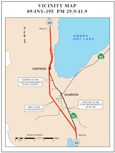 In January 2018, the CTC approved a request from the
California Department of Transportation’s (Department) to adopt US 395 in Inyo County from INY 29.9 to INY 41.9 as a controlled access
highway, redesignate a segment of superseded US 395 as Route 190 and, upon
construction completion of the new controlled access highway, relinquish
the remaining portion of the superseded US 395 to Inyo County. The
Department proposes to adopt this 12.14 mile section of US 395 to
construct a new expressway within the adoption limits, which will improve
safety for the traveling public, raise the level of service, and provide a
continuous four-lane facility in Inyo County. A final Environmental Impact
Report/Environmental Assessment (EIR/EA) prepared pursuant to the
California Environmental Quality Act and the National Environmental Policy
Act was approved by the Department on March 7, 2017 and by the Federal
Highway Administration (FHWA) on May 26, 2017. The Department approved a
project report on June 27, 2017 recommending construction of the new US 395 expressway on a new alignment and redesignation of a portion of the
superseded segment as Route 190. The remaining portion of the superseded
highway will be relinquished to Inyo County after project construction
completion.
In January 2018, the CTC approved a request from the
California Department of Transportation’s (Department) to adopt US 395 in Inyo County from INY 29.9 to INY 41.9 as a controlled access
highway, redesignate a segment of superseded US 395 as Route 190 and, upon
construction completion of the new controlled access highway, relinquish
the remaining portion of the superseded US 395 to Inyo County. The
Department proposes to adopt this 12.14 mile section of US 395 to
construct a new expressway within the adoption limits, which will improve
safety for the traveling public, raise the level of service, and provide a
continuous four-lane facility in Inyo County. A final Environmental Impact
Report/Environmental Assessment (EIR/EA) prepared pursuant to the
California Environmental Quality Act and the National Environmental Policy
Act was approved by the Department on March 7, 2017 and by the Federal
Highway Administration (FHWA) on May 26, 2017. The Department approved a
project report on June 27, 2017 recommending construction of the new US 395 expressway on a new alignment and redesignation of a portion of the
superseded segment as Route 190. The remaining portion of the superseded
highway will be relinquished to Inyo County after project construction
completion.
Within the proposed adoption limits, U.S. Highway 395 is currently a two-lane undivided conventional highway. It traverses gently sloping terrain at elevations between 3,600 and 3,900 feet as it passes through the communities of Olancha and Cartago. Olancha is sparsely developed with a few businesses, a post office, and one service station. Cartago is located about three miles north of Olancha and is primarily a residential community. There are a few businesses and residences adjacent to the highway, but in general, the highway corridor is rural in nature. This project will connect the four-lane divided expressway segments at both ends of the adoption limits.
The existing highway generally consists of two 12-foot lanes and 8-foot paved shoulders within 100 feet of right of way. There are no shoulder improvements such as curb, gutter or sidewalk throughout this section of the highway. There is no median and approximately 50 percent of the highway is barrier striped to prevent passing. There are undivided passing lanes for both northbound and southbound traffic north of Cartago. The posted speed limits vary from 65 mph outside of the communities to 55 mph within the communities. In addition to the intersection with Route 190, there are six other public road connections and numerous other private roads and access points to the existing highway within the project limits.
Due to the numerous access points and limited sight distances along US 395, passing zones are limited. There is also a mixture of slower recreational and commercial vehicles, local residential and business traffic, and faster through traffic. The limited passing opportunities and mixed traffic has led to queuing within the communities, driver frustration, and frequent unsafe passing maneuvers. In 2006, shoulders were widened and the posted speed limit reduced within the communities, but the fatal accident rate remained at 1.29 times the statewide average. This section of highway is currently operating at Level of Service (LOS) D and is projected to fall to LOS E within the 20-year planning period.
The proposed route adoption will allow the Department to construct the expressway on a new alignment. It will eliminate traffic congestion and significantly increase safety for the traveling public by separating opposing traffic, removing passing restrictions, and controlling access points. Finally, the new expressway will provide route continuity on US 395 and will complete the construction of four-lanes throughout the US 395 corridor in Inyo County.
A draft project report was approved in September 2010 to evaluate five alternatives. Their environmental impacts were evaluated in an Initial Study/Environmental Assessment circulated end of 2010. Focused studies performed for the preferred alternative determined that mitigation of cultural impacts to insignificant levels may not be possible. As a result, the environmental document was elevated to a Draft Environmental Impact Report/Environmental Assessment (EIR/EA) which allowed the Department to discuss the potential cultural impacts and evaluate the preferred alternative. The Draft EIR/EA was circulated from August to October 2015, after which the preferred alternative was selected.
The portion of the existing highway between the intersection with Route 190 and the southern intersection with the new expressway is proposed to be redesignated as Route 190. A concurrent Commission’s action to approve the redesignation of this portion of US 395 as Route 190 is on the January 2018 Commission agenda. This action will reestablish the terminus of Route 190 at US 395. The remaining portion of the superseded highway between the intersection with Route 190 and north of the community of Cartago will be relinquished to Inyo County after project completion. The superseded highway will continue to provide a local route that preserves the existing uses and access along the existing corridor. The project will also construct or reconstruct a couple other county roads, all of which will be relinquished to Inyo County.
This project has been jointly funded by the Inyo County
Local Transportation Commission, Mono County Local Transportation
Commission, Kern Council of Governments, and the Interregional Improvement
Program. Due to shortfalls in the programming available for the 2016 State
Transportation Improvement Program (STIP), the Construction Capital and
Construction Support components were deprogrammed. Funding for the
Construction Capital and Construction Support components have been
restored in the proposed 2018 STIP. The estimated total cost of the
project, including construction and right of way costs escalated to the
year of construction, is $138,819,000. The project is scheduled to start
construction in September 2020.The Department and Inyo County have agreed
with the public road openings proposed for the new expressway and intend
to execute a Controlled Access Highway Agreement following the
Commission’s approval of this route adoption. Currently, the
Department and Inyo County are negotiating the terms of the relinquishment
agreement. Inyo County has agreed in principle to accept the
relinquishment of the facilities.
(Source: CTC Agenda, January 2018, Agenda Item 2.3a(1))The 2018STIP,
approved at the CTC March 2018 meeting, appears to restore funding
from this, moving the total from $11,420K to $41,487K, including an
additional $23,495K in FY21-22, presumably for construction. The project
is near Olancha and Cartago, south of the Los Angeles Aqueduct Bridge to
south of the Ash Creek Bridge. Widen 2 lane conventional highway to 4 lane
expressway. There also appears to be additional funding for this from the
Kern and Mono County shares.
In March 2020, the CTC approved the 2020 STIP, which
appears to continue the programmed funding for PPNO 0170 "Olancha-Cartago
4-lane expressway (RIP 25%)" in both Inyo and Kern counties. This funding
includes $17,992K in prior year funding, and 23,495K in FY21-22 for Inyo
and $4,498K in prior year funding and 9,295K in FY21-22 for Kern. It also
included PPNO 0170 Olancha-Cartago 4-lane expressway (IIP 40%), in the
Interregional portion of the STIP with no change in programming: $17,992K
in prior year funding. and $49,615K in FY21-22.
(Source: March 2020 CTC Agenda, Item 4.7, 2020 STIP
Adopted 3/25/2020)
In April 2020, it was reported that Caltrans was in the
final stages of design and right-of-way acquisition for the
Olancha-Cartago 4-Lane project. The project will upgrade 12.6 miles of the
current two-lane highway to a four-lane access-controlled expressway. The
new alignment will begin four miles south of Olancha to four miles north
of Cartago and will close the gap between the existing four-lane sections
to the north and the south. Preconstruction activities include utility
verification and relocation, vegetation removal and/or relocation, staking
the new alignment, installing desert tortoise exclusion fence, and other
various preliminary items. This $83 million-dollar project is jointly
funded by Inyo and Mono Counties’ Local Transportation Commissions,
Kern Council of Governments, and Caltrans with State Transportation
Improvement Program funds. Project completion is tentatively scheduled for
late 2023.
(Source: Sierra Wave Media)
In October 2020, the CTC was given notice of a proposed
amendment to the US 395 – Olancha and Cartago 4-lane Expressway
project in Inyo county (PPNO 0170) (EA 21340/21341) (INY 29.200/41.800),
to separate out a portion of the mitigation work ( $2,920,000 $3,058,000)
into a new project, identified as the Olancha and Cartago Expressway
Desert Tortoise Exclusion Fence project (PPNO 0170B). This project had
extensive and complex environmental challenges, which culminated in
successfully achieving environmental clearance in June 2017, after efforts
for over 10 years, with an Environmental Impact Report/Environmental
Assessment. During the design phase, the archaeological
pre-mitigation work needed to be completed. A separate
archaeological pre-mitigation project for $5,000,000 was programmed for
this project, which was allocated by the Commission in May 2018. In
addition, avoidance and mitigation measures are required to protect the
Desert Tortoise. The avoidance and mitigation fencing are required
to be completed prior to pre-construction activities such as geo-tech
investigations, geo-tech boring, geo-archeology coring, archeological data
recovery and utility relocation. In addition, the fence must be in
place prior to commencing construction activities such clearing and
grubbing vegetation, culvert installation, roadway construction and bridge
construction. The funding for the fencing was identified and budgeted in
the Right of Way (R/W) component. R/W funding for the project was
programmed in 2014 and was done as a lump sum allocation per STIP
Guidelines. It had been the standard practice to execute the
construction of the fencing through a service contract with R/W funds.
However, in December 2018, there was a policy change that no longer allows
R/W capital funds to be used in that manner, and a contract is necessary
to construct the fencing requiring the work to be split and delivered
separate from the main project construction. The Desert Tortoise Exclusion
Fence project cost is $2,920,000 $3,058,000.
The proposal is to separate the cost and scope of the fence from the
construction capital of the main project. This separate project would be
able to begin ahead of the major construction contract. With a separate
project to address the fencing, it reduces the risk of delays to the main
project. The current estimated construction capital cost of the main
project remains on budget. The right of way cost estimate for the
main project is currently under budget with potential cost savings to be
reported at time of construction allocation. By having the fencing in
place, allows the construction to proceed without delays. This change to
separate out the fencing cost, from the construction capital, allows the
project to proceed, mitigates the risk of delays since the original
process of implementing as a service is no longer feasible. It
should be noted that the new alignment can be cleared at any time after
the fence is constructed, and the Desert Tortoise fencing would not be the
critical path for the prime contractor. In December 2020, the amendment
(with a corrected amount for the fencing) was voted upon.
(Source: October 2020 CTC Agenda, Agenda Item
2.1b.(1); December 2020 CTC Agenda, Agenda Item 2.1a.(2))
In December 2020, the CTC approved an allocation of
$3,058,000 for the State-Administered STIP Olancha and Cartago Expressway
Desert Tortoise Exclusion Fence project (PPNO 0170B ProjID 0914000036 EA
21341) (395 INY 29.200/41.800), on the State Highway System, in Inyo
County, programmed in 2021-22. These funds are for installation of Desert
Tortoise Exclusion Fencing.
(Source: December 2020 CTC Agenda, Agenda Item
2.5c.(5))
In May 2021, the CTC approved an allocation of
$92,966,000 for the State-Administered STIP Olancha and Cartago Expressway
project (PPNO 0170), on the State Highway System, in Inyo County,
programmed in 2021-22. The allocation is divided as follows: $83,116,000
from the Budget Act of 2020, Budget Act Items 2660-301-0042 and
2660-301-0890 for construction and $9,850,000 for construction
engineering. Allocation time extensions for other projects programmed
within the current, fiscal year have allowed for sufficient capacity to
become available to fund this advanced project allocation. Details:
09-Iny-395 29.2/41.8. PPNO 09-0170; ProjID 0900000030; EA 21340. Olancha
and Cartago Expressway. US 395 near Olancha and Cartago, south
of the Los Angeles Aqueduct Bridge to south of the Ash Creek Bridge.
Widen 2 lane conventional highway to 4 lane expressway. (Future
consideration of funding approved under Resolution E-17-53; August 2017.)
(Source: May 2021 CTC Agenda, Agenda Item 2.5c.(5))
In July 2022, it was reported that ground was broken
on the Olancha-Cartago 4-Lane Project. The Olancha-Cartago 4-Lane
Expressway project will pass west of the town of Olancha and the Los
Angeles Aqueduct. Once the alignment crosses Olancha Creek, the project
will cross the Los Angeles Aqueduct and continue north through Cartago
along the existing highway to meet up with the four-lane section of US 395
to the north of Cartago. The northbound and southbound lanes will be
separated by a 100-foot unpaved median. As of July 2022, crews were
placing rebar on the footing for the bridge abutments and wingwalls on the
south side of the Los Angeles aqueduct; excavation for the bridge
abutments on the south side of the Los Angeles Aqueduct was completed in
June 2022 and excavation begun for the abutments on the north side.
Drainage system installation continues throughout the project.
(Source: District 9 Project Page, July 2022)
In April 2012, the CTC authorized SHOPP funding on Route 190, in Inyo County, 09-INY-190 R65.9/R66.5 Near Panamint Springs, from 8.0 miles east of Panamint Valley Road to 10 miles west of Wildrose Road. $1,018,000 to realign roadway to allow the construction of a shoulder catchment area for falling rocks and minimize the potential of traffic collisions.
In December 2023, the CTC approved amending the following project into
the 2022 SHOPP: 09-Iny-190 68.8/128.0. PPNO 09-2734; ProjID 0924000008; EA
40110. Route 190 Near Bishop, from 7.7 miles west of Wildrose Canyon Road
to 5.5 miles east of West Dante View Road. Clear flood debris from
roadway, reconstruct damaged roadway embankment and fill erosion gullies,
grade eroded dirt shoulders and reestablish roadside geometry, reconstruct
damaged pavement and drainage systems, rebuild washed out roadway
embankment and pavement washouts, and perform traffic control. Note: On
August 20, 2023, tropical storm Hilary brought heavy rains that caused
extensive flooding which caused numerous partial and full pavement
washouts, deposition of rock and mud flood debris onto the roadway,
shoulders, and into drainage courses, erosion of dirt shoulders and
roadway embankment up to 7 feet deep, plugged culverts, and damaged
earthen flood control dikes, which has led to a long-term full road
closure to the traveling public. This project will clear flood
debris from roadway, reconstruct damaged roadway embankment and fill
erosion gullies, grade eroded dirt shoulders and reestablish roadside
geometry, reconstruct damaged pavement and drainage systems, rebuild
washed out roadway embankment and pavement washouts, and perform traffic
control. Allocation ($ × $1000) PA&ED $0; PS&E $0; R/W Sup
$0; Con Sup $2,750; R/W Cap $0; Const Cap $11,000; TOTAL $13,750. FY23-24.
(Source: December 2023 CTC Agenda, Agenda Item 2.1a.(1a) #23)
Panamint Springs / Towne Pass Curves Project (09-Iny-190, PM 69.2/69.8)
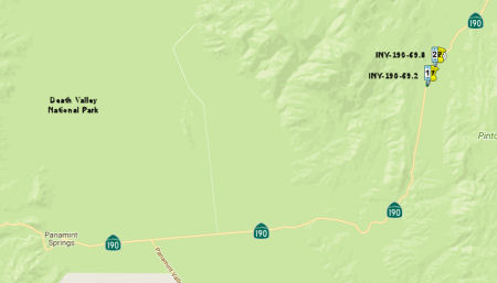 In June 2017, the CTC authorized for future consideration
of funding a project that realigns approximately 0.6 mile of Route 190
(09-Iny-190, PM 69.2/69.8) within Death Valley National Park near Towne
Pass near the town of Panamint Springs in Inyo County. The project will be
funded from State Highway Operation and Protection Program (SHOPP) funds
and is programmed in the 2016 SHOPP for an estimated $6.7 million
construction (capital and support) and Right of Way (capital and support).
Construction is tentatively scheduled to begin in Fiscal Year 2018-19. The
scope, as described for the preferred alternative, is consistent with the
project scope programmed by the Commission in the 2016 SHOPP. A copy of
the MND has been provided to Commission staff. The project will result in
less than significant impacts to the environment after mitigation. The
following resource areas may be impacted by the project: cultural
resources and visual/aesthetics. Avoidance and minimization measures will
reduce any potential effects on the environment. These measures include,
but are not limited to, disturbed areas will be recontoured and
revegetated, and a historic context shall be developed for future use in
evaluation of the Eichbaum Toll Road. As a result, an MND was completed
for this project.
In June 2017, the CTC authorized for future consideration
of funding a project that realigns approximately 0.6 mile of Route 190
(09-Iny-190, PM 69.2/69.8) within Death Valley National Park near Towne
Pass near the town of Panamint Springs in Inyo County. The project will be
funded from State Highway Operation and Protection Program (SHOPP) funds
and is programmed in the 2016 SHOPP for an estimated $6.7 million
construction (capital and support) and Right of Way (capital and support).
Construction is tentatively scheduled to begin in Fiscal Year 2018-19. The
scope, as described for the preferred alternative, is consistent with the
project scope programmed by the Commission in the 2016 SHOPP. A copy of
the MND has been provided to Commission staff. The project will result in
less than significant impacts to the environment after mitigation. The
following resource areas may be impacted by the project: cultural
resources and visual/aesthetics. Avoidance and minimization measures will
reduce any potential effects on the environment. These measures include,
but are not limited to, disturbed areas will be recontoured and
revegetated, and a historic context shall be developed for future use in
evaluation of the Eichbaum Toll Road. As a result, an MND was completed
for this project.
In August 2018, the CTC approved a $4.2 million project
on Route 190 in Death Valley near Panamint Springs that will realign
curves and widen shoulders to reduce the number and severity of
collisions.
(Source: Mojave Desert News, 8/21/2018)
 Naming
 The four-mile portion of Route 190 between its intersection with
Pleasant Oak Drive and just south of HQ Drive, in the County of Tulare
between postmile TUL 22.53 and postmile TUL 26.53, is named the "Sheriff’s
Officers Deputy Sheriff Scott Ballantyne and Sheriff’s Pilot James
Chavez Memorial Highway". It was named in memory of Scott
Ballantyne and James Chavez. Scott Ballantyne, Deputy II with the Tulare
County Sheriff’s Office, was born at Fort Campbell, Kentucky in
September 1963. As a young boy, Scott Ballantyne moved to Visalia,
California, with his parents in 1968; he graduated from Redwood High
School in Visalia in 1982 and attended College of the Sequoias and Fresno
State College. In 1989, Scott Ballantyne enrolled in and completed the
Peace Officer Standards and Training (POST) Academy in Visalia,
California. Officer Ballantyne began employment with the Tulare County
Sheriff’s Office as a deputy in 1989 and held several positions
while in the Sheriff’s Office, including that of patrol deputy,
evidence technician, and courtroom bailiff for the late Judge Paul
Vortmann. In 2014, Officer Ballantyne applied for and was selected to
serve in the Sheriff’s aerial surveillance program and greatly
enjoyed participating in aerial surveillance, forming a close friendship
with his pilot, Officer James Chavez. James Chavez was born in December
1970, to Patricia Chavez and Jacinto Chavez in Stockton, California, where
he was raised with his brothers Charles (Carlos), Felipe, and Victor
Chavez. He graduated from St. Mary’s High School of Stockton in
1988, and after graduation voluntarily attended Pacific Crest Outward
Bound School. He went on to Fresno State University and graduated with a
Bachelor of Arts in Geography in 1995. James Chavez became a Navy Officer
in 1993, and served one overseas deployment aboard the USS Abraham Lincoln
in 1998, serving as a Maintenance Officer. In 2005 James Chavez
transferred to the Army National Guard and was able to go to flight school
to learn to fly the Blackhawk helicopter at Fort Rucker, Alabama, in May
of 2006. While on a year-long deployment to Iraq in 2010 to 2011, he
served as Company Commander, for Company B, in the 640th Aviation Support
Battalion and flew many Blackhawk missions earning a Bronze Star Medal and
a Combat Action Badge. He had a total of over 900 hours flying the
Blackhawk and received his 20-year letter from the military confirming his
eligibility for retirement benefits in 2013, but continued to serve
actively with the United States Army Reserves, reaching the rank of Major,
and working on courses toward the next rank of Lieutenant Colonel. After
being a volunteer pilot for the Tulare County Sheriff’s Aero
Squadron for 13 years and then a volunteer Sheriff’s pilot for
several months, James Chavez was hired and sworn in as the Sheriff One
pilot on January 12, 2015, a position he loved passionately, while
continuing to serve his Army Reserve weekends at the 1st Brigade Pacific
Division 75th Training Command in Garden Grove, California. Deputy Sheriff
Ballantyne and Sheriff’s Pilot Chavez died in a tragic plane
accident in Springville, California, on February 10, 2016, while engaged
in aerial surveillance for the Tulare County Sheriff’s Office. Named
by Assembly Concurrent Resolution (ACR) 169, Res. Chapter 146, 8/17/2018.
The four-mile portion of Route 190 between its intersection with
Pleasant Oak Drive and just south of HQ Drive, in the County of Tulare
between postmile TUL 22.53 and postmile TUL 26.53, is named the "Sheriff’s
Officers Deputy Sheriff Scott Ballantyne and Sheriff’s Pilot James
Chavez Memorial Highway". It was named in memory of Scott
Ballantyne and James Chavez. Scott Ballantyne, Deputy II with the Tulare
County Sheriff’s Office, was born at Fort Campbell, Kentucky in
September 1963. As a young boy, Scott Ballantyne moved to Visalia,
California, with his parents in 1968; he graduated from Redwood High
School in Visalia in 1982 and attended College of the Sequoias and Fresno
State College. In 1989, Scott Ballantyne enrolled in and completed the
Peace Officer Standards and Training (POST) Academy in Visalia,
California. Officer Ballantyne began employment with the Tulare County
Sheriff’s Office as a deputy in 1989 and held several positions
while in the Sheriff’s Office, including that of patrol deputy,
evidence technician, and courtroom bailiff for the late Judge Paul
Vortmann. In 2014, Officer Ballantyne applied for and was selected to
serve in the Sheriff’s aerial surveillance program and greatly
enjoyed participating in aerial surveillance, forming a close friendship
with his pilot, Officer James Chavez. James Chavez was born in December
1970, to Patricia Chavez and Jacinto Chavez in Stockton, California, where
he was raised with his brothers Charles (Carlos), Felipe, and Victor
Chavez. He graduated from St. Mary’s High School of Stockton in
1988, and after graduation voluntarily attended Pacific Crest Outward
Bound School. He went on to Fresno State University and graduated with a
Bachelor of Arts in Geography in 1995. James Chavez became a Navy Officer
in 1993, and served one overseas deployment aboard the USS Abraham Lincoln
in 1998, serving as a Maintenance Officer. In 2005 James Chavez
transferred to the Army National Guard and was able to go to flight school
to learn to fly the Blackhawk helicopter at Fort Rucker, Alabama, in May
of 2006. While on a year-long deployment to Iraq in 2010 to 2011, he
served as Company Commander, for Company B, in the 640th Aviation Support
Battalion and flew many Blackhawk missions earning a Bronze Star Medal and
a Combat Action Badge. He had a total of over 900 hours flying the
Blackhawk and received his 20-year letter from the military confirming his
eligibility for retirement benefits in 2013, but continued to serve
actively with the United States Army Reserves, reaching the rank of Major,
and working on courses toward the next rank of Lieutenant Colonel. After
being a volunteer pilot for the Tulare County Sheriff’s Aero
Squadron for 13 years and then a volunteer Sheriff’s pilot for
several months, James Chavez was hired and sworn in as the Sheriff One
pilot on January 12, 2015, a position he loved passionately, while
continuing to serve his Army Reserve weekends at the 1st Brigade Pacific
Division 75th Training Command in Garden Grove, California. Deputy Sheriff
Ballantyne and Sheriff’s Pilot Chavez died in a tragic plane
accident in Springville, California, on February 10, 2016, while engaged
in aerial surveillance for the Tulare County Sheriff’s Office. Named
by Assembly Concurrent Resolution (ACR) 169, Res. Chapter 146, 8/17/2018.
(Image source: Facebook; Facebook)
 Scenic Route
 Freeway
[SHC 253.7] From Route 136 near Keeler to Route 127 near Death Valley Junction (never upgraded). Added to the Freeway and Expressway system in 1959.
 Interregional Route
 Other WWW Links
 Statistics
Overall statistics for Route 190:
 Pre-1964 Legislative Route
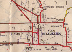 In 1933, Chapter 767 added the routes from "[LRN 9] near
San Dimas to [LRN 26] near Redlands via Highland Avenue" and "[LRN 26]
near Redlands to [LRN 43] near Big Bear Lake via Barton Flats" to the
highway system. In 1935, these were added to the highway code as LRN 190,
with the route:
In 1933, Chapter 767 added the routes from "[LRN 9] near
San Dimas to [LRN 26] near Redlands via Highland Avenue" and "[LRN 26]
near Redlands to [LRN 43] near Big Bear Lake via Barton Flats" to the
highway system. In 1935, these were added to the highway code as LRN 190,
with the route:
The map to the right shows LRN 190 (Route 30) to its junction with LRN 207. This is where the route turned into Route 38.
In 1957, Chapter 1911 deleted the specific routing via Highland Avenue from segment (a).
This route was signed as follows:
This was Route 30 between Route 57 and I-10; it is present day Route 210. It originally ran along Highland Avenue
This is present-day Route 38.
LRN 190 included Orange Ave. in Redlands; the main line turned left on
Lugonia along what became Route 38; the several blocks south from there on
Orange was a LRN 190 spur connecting to, originally the Redlands Blvd.
alignment of US 70/US 99 and later cut back a couple of blocks to I-10.
The route was always legislatively defined as going to Big Bear, but that
extension didn't come about until 1962, when the highway, essentially the
"back way" up to Big Bear, was finally completed and signed as Route 38,
including the short section into central Redlands. The original Lugonia
segment was state-maintained up to a few miles west of Forest Falls; the
newer construction turned north and east from there to ascend the
mountain. So about 30 years passed between the designations of Route 30
and Route 38.
(Source: Scott Parker (SParker) at AAroads, 7/1/2016)
© 1996-2020 Daniel P. Faigin.
Maintained by: Daniel P. Faigin
<webmaster@cahighways.org>.
 Route 189
 Route 191