
 California Highways:
Click here for a key to the symbols used. An explanation of acronyms may be found at the bottom of the page.
 Routing
 Post 1964 Signage History
This route remains as defined in 1963. It was not signed as Route 242 until the late 1980s.
 Pre 1964 Signage History
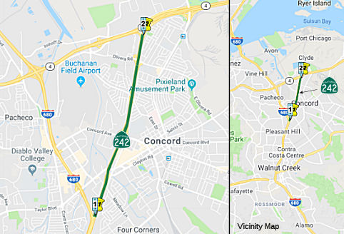
This was LRN 75 (defined in 1931). It was originally part of Route 24, but became Route 242 after a bypass route between Walnut Creek at Pittsburg was defined. It was first signed as part of Route 24 in 1935; the last state highway map showing it as Route 24 is in 1986. There are varying dates for the start of the Route 242 signage from 1989 to 1991. The bypass is LRN 256, defined in 1959.
By 1955, this segment (as Route 24) was shown as complete between the Ohmer Hill1 area of Concord (near Port Chicago) south to Concord Avenue, and "proposed" between there and the current I-680 junction in Pleasant Hill. Between Route 21 and the ending of the now-Route 242 freeway, Route 24 took Monument Boulevard, Galindo Street, and Concord Avenue.
1: Locality Naming Note: Ohmer Hill is a current site of a BART station, and used to be a stop on the Sacramento Northern RR. The namesake of the hill, Ohmer Fare Register Company, was a Ohio company that had incorporated back in the 19th century and was in the business of making taxi fare meters as well as those on the Sacramento Northern. The company was merged into NCR.
 Status
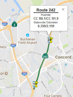 In August 2017, the CTC approved for future consideration
of funding 04-CC-242, PM R0.1/R1.9 Route 242/Clayton Road Ramps Project.
This project in Contra Costa County will modify and improve the
interchange and on/off ramps at the Route 242/Clayton Road interchange in
the city of Concord. The project is not fully funded. The estimated
project cost is $65.7 million. $34.7 million is currently programmed in
the Reginal Transportation Plan. The project start date will be determined
when total funding is finalized. A copy of the ND has been provided to
Commission staff. The project will result in less than significant impacts
to the environment. As a result, an ND was completed for this project.
In August 2017, the CTC approved for future consideration
of funding 04-CC-242, PM R0.1/R1.9 Route 242/Clayton Road Ramps Project.
This project in Contra Costa County will modify and improve the
interchange and on/off ramps at the Route 242/Clayton Road interchange in
the city of Concord. The project is not fully funded. The estimated
project cost is $65.7 million. $34.7 million is currently programmed in
the Reginal Transportation Plan. The project start date will be determined
when total funding is finalized. A copy of the ND has been provided to
Commission staff. The project will result in less than significant impacts
to the environment. As a result, an ND was completed for this project.
 Exit Information
 Other WWW Links
 Classified Landcaped Freeway
The following segments are designated as Classified Landscaped Freeway:
| County | Route | Starting PM | Ending PM |
| Contra Costa | 242 | 0.00 | R3.40 |
 Freeway
[SHC 253.1] Entire route. Added to the Freeway and Expressway system in 1959.
 Statistics
Overall statistics for Route 242:
 Pre-1964 Legislative Route
In 1959, Chapter 1382 defined LRN 242 as “[LRN 6] between Harbor Boulevard and the Yolo Causeway west of Sacramento to [LRN 3] near Watt Avenue”. This route ran from US 40 (present-day I-80) between Harbor Blvd. and the Yolo Causeway W of Sacramento to US 40 (present-day I-80) near Watt Avenue. This is the present-day freeway routing of I-80 N of the city of Sacramento.
© 1996-2020 Daniel P. Faigin.
Maintained by: Daniel P. Faigin
<webmaster@cahighways.org>.
 From Route
  Route 241
 Route 243