
 California Highways:
Click here for a key to the symbols used. An explanation of acronyms may be found at the bottom of the page.
 Routing
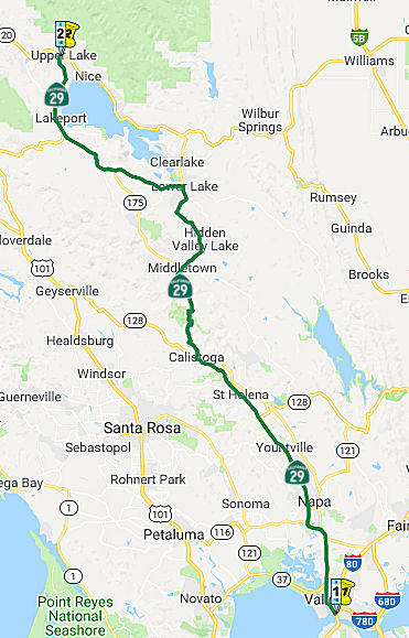 From Route 80 near Vallejo to Route 20 near Upper Lake via
the vicinity of Napa, via Calistoga, via Lower Lake, passing south of
Kelseyville and via Lakeport.
From Route 80 near Vallejo to Route 20 near Upper Lake via
the vicinity of Napa, via Calistoga, via Lower Lake, passing south of
Kelseyville and via Lakeport.
 Post 1964 Signage History
In 1963, Route 29 was defined as “from Route 80 near the Carquinez Bridge to Route 20 near Upper Lake via the vicinity of Napa, via Calistoga, via Lower Lake, passing south of Kelseyville and via Lakeport.” In 1965, Chapter 1371 reworded the origin of the route to be "near Vallejo" instead of the Carquinez Bridge.
Tom Fearer notes that in the 1964 renumbering, Route 29 didn't have a
change of terminus points. However, Route 29 did have a major realignment
south of Clear Lake onto what had been LRN 243 and Route 53/LRN 49 between
Lower Lake south to Middletown. What had been previously Route 29 through
Cobb was assigned to Route 175.
(Source: Gribblenation Blog (Tom Fearer): California State Rotue 29 (sic))
A 1975 state highway map appears to show an adopted routing from just S of the Route 37/I-80 intersection to Route 29 near American Canyon Road.
In the 1980s, the Napa River Bridge and the new freeway bypassed the segment of Route 29 near Napa from Route 29 near Soscol Road to Route 121 at Imola Avenue. The bypassed segments were transferred to Route 121 and Route 221, changing their definitions (Chapter 409, 1984), but no change was necessary in Route 29's definition.
Route 29 between Lakeport and Kelseyville was given an adopted freeway routing, which is now an expressway. The old route is now Soda Bay Road (Route 281), Big Valley Road to Kelsey Creek, Finley Road south to the Kelseyville city limit, and Main Street back to Route 29.
 Pre 1964 Signage History
 In 1909, the first bond act funded LRN 8, which included the portion
of eventual Route 29 from 4 mi S of Napa (the present Route 12/Route 29
junction) to Napa (present-day Route 121). The future Route 29 was
extended again in 1931, when the routing from LRN 8 (now Route 12) near
Cordelia (which is 4 mi S of Napa) via American Canyon to LRN 14 (US 40,
now I-80) was added to the state highway system. This later portion became
part of LRN 74. The situation in 1931 was that traffic between the
Sacramento Valley and the bay cities could not find the direct and most
advantageous passage from LRN 8 to LRN 14 over connected state highways.
LRN 7 (roughly today's I-580) was available via the Martinez Ferry, but a
better road and bridge facility implied almost exclusive use of a county
highway from the Napa Wye to the Carquinez Straits. It was felt that a
state route should be established to service the through traffic which was
forced onto county roads. The route proposed for LRN 74 was a favorable
route from Cordelia south to LRN 14 by way of American Canyon. This route
was 5 miles shorter than the route using the Napa Wye and 9 miles shorter
than the routing through Martinez. The new route avoided the
disadvantageous passage over steep intersecting streets in Vallejo. It was
considered appropriate to add it to the state highway system as it would
serve a very large volume of state traffic now carried over a county
highway.
In 1909, the first bond act funded LRN 8, which included the portion
of eventual Route 29 from 4 mi S of Napa (the present Route 12/Route 29
junction) to Napa (present-day Route 121). The future Route 29 was
extended again in 1931, when the routing from LRN 8 (now Route 12) near
Cordelia (which is 4 mi S of Napa) via American Canyon to LRN 14 (US 40,
now I-80) was added to the state highway system. This later portion became
part of LRN 74. The situation in 1931 was that traffic between the
Sacramento Valley and the bay cities could not find the direct and most
advantageous passage from LRN 8 to LRN 14 over connected state highways.
LRN 7 (roughly today's I-580) was available via the Martinez Ferry, but a
better road and bridge facility implied almost exclusive use of a county
highway from the Napa Wye to the Carquinez Straits. It was felt that a
state route should be established to service the through traffic which was
forced onto county roads. The route proposed for LRN 74 was a favorable
route from Cordelia south to LRN 14 by way of American Canyon. This route
was 5 miles shorter than the route using the Napa Wye and 9 miles shorter
than the routing through Martinez. The new route avoided the
disadvantageous passage over steep intersecting streets in Vallejo. It was
considered appropriate to add it to the state highway system as it would
serve a very large volume of state traffic now carried over a county
highway.
In 1931, the portion between Route 12 and I-80 was at one time signed as (temp) US 40. In 1934, Route 29 was signed along this route from Vallejo to Upper Lake, via Calistoga and Lakeport. The portion between I-80 near Vallejo to Curtola Parkway in Vallejo was defined in 1937, the remainder to 4 mi S of Napa in 1931.
A 1935 Goshua Highway Map of California shows Route 29 aligned through
Cobb on what would be present day Route 175. Within Napa, Route 29 was
aligned through downtown and followed present day Route 221 towards
Vallejo. Within the City of Napa, Route 29 southbound originally utilized
Trancas Street, Jefferson Street, 3rd Street, and Soscol Avenue.
Route 29 was moved to a bypass of downtown Napa via the alignment of the
modern freeway circa 1950.
(Source: Gribblenation Blog (Tom Fearer): California State Rotue 29 (sic))
From 4 mi S of Napa (present-day Route 12) to Napa (present-day Route 121), Route 29 was LRN 8. Portions of this were cosigned with Route 12; the cosigned portion is now present-day Route 221 (signed as Route 121). The small portion between Route 221 and Route 121 in Napa was not part of the highway system until 1984 when the Napa River Bridge and a freeway bypass were constructed.
Between Route 121 in Napa and Middletown, near Lower Lake, Route 29 was LRN 49. The portion between Napa and Calistoga was defined in 1993, from Calistoga to Middletown was defined in 1919. Before 1964, Route 29 ran from Middletown to Lower Lake through Whispering Pine and Cobb (present-day Route 175); this was LRN 89, defined in 1933. It rejoined the present-day Route 29 5 mi SE of Kelseyville.
The present-day Route 29 runs along what was Route 53 (LRN 49, defined in 1919) between Middletown and Lower Lake. The route continued as Route 29 (but was LRN 243, defined in 1959) between Lower Lake and the present-day Route 175 5 mi SE of Kelseyville. The Route 53 segment was renumbered as Route 29 in 1964.
It then ran, signed as Route 29 but LRN 89, along the lower edge of Clear Lake to 3 mi NW of Kelseyville, and then on to Route 20. This segment was defined in 1933.
 In 1961, the California Highway Commission considered the
adoption of 6 mi of freeway on Route 29 between the Hopland Road (LRN 16,
later Route 175, ~LAK R40.158) and the vicinity of Wilkerson Rd. 1 mi S of
Kelseyville (~ LAK R34.573). The route runs about 0.5 mi S of the existing
highway and eliminates many right angle turns and sharp curves. The
original route used Soda Bay Road, then along Big Valley Rd, Thomas Drive,
Big Valley Road, and Main Street Kelseyville. This is now all County Road
541. The project was estimated to cost ~ $420,000.
In 1961, the California Highway Commission considered the
adoption of 6 mi of freeway on Route 29 between the Hopland Road (LRN 16,
later Route 175, ~LAK R40.158) and the vicinity of Wilkerson Rd. 1 mi S of
Kelseyville (~ LAK R34.573). The route runs about 0.5 mi S of the existing
highway and eliminates many right angle turns and sharp curves. The
original route used Soda Bay Road, then along Big Valley Rd, Thomas Drive,
Big Valley Road, and Main Street Kelseyville. This is now all County Road
541. The project was estimated to cost ~ $420,000.
(Source: Santa Rosa Press Democrat, 11/17/1961, via Joel Windmiller,
2/1/2023)
 Status
Vallejo to Yountville, through the City of Napa
On the north end of Vallejo, Route 29 meets Route 37 (04-SOL-29, PM 4.869), which is a stub freeway from I-80 east to this intersection. Caltrans is building a freeway interchange here, where Route 37 will fly over Route 29.
In May 2011, the Napa County Board of Supervisors requested that Caltrans perform a corridor study on Route 29 between Route 37 in Vallejo and Napa Junction Road north of American Canyon (~ SOL 5.034 to NAP R2.053). The study would look for both long- and short-term solutions to the traffic problems on Route 29, a main thoroughfare clogged with morning and evening rush-hour traffic.
Broadway District Specific Plan (~ NAP 0.039 to NAP NAP R2.768)
 In July 2020, it was reported that American Canyon will seek more public opinion
before finalizing the plan for Route 29. American Canyon last year passed
the Broadway District Specific Plan – much of Route 29 within the city is
known as Broadway. A hodgepodge of new development, old development and
vacant lots is to be transformed into a coherent,
pedestrian-and-cyclist-friendly whole. The Specific Plan study area
contains approximately 345 acres located on both sides of Broadway
extending 2.38 miles north from the County line to Green Island Road. The
Broadway District Specific Plan calls for 1,200 new apartments, townhouses
and other residential units and 840,000 square feet of new commercial
space on 292 acres scattered along the highway. It calls for persuading
Caltrans to impose a 35 mph speed limit and adding such features as
landscaped medians. Since the plan passed, however, two things have
happened. One is the lawsuit settlement with Davis-based California Clean
Energy Committee, which had alleged American Canyon’s plan
underestimated the magnitude of future traffic congestion. The second is
the creation of the Napa Valley Transportation Authority’s latest
south county Route 29 plan. The lawsuit settlement requires American
Canyon to adopt various Route 29 plan provisions as its own. Various
lawsuit settlement requirements seek to give buses an advantage in
navigating congestion. The stated goal is to convince more people to get
out of their cars and ride the bus. Having buses use the shoulders at
times during rush hour is one idea. The proposed Broadway plan amendment
acknowledges this could pose a conflict with bicyclists. One notable
proposed change is to remove from the Broadway District Specific Plan the
idea of expanding Route 29 from four to six lanes through American Canyon.
Even that change wouldn’t necessarily take a highway widening off
the table forever, as the highway right-of-way is wide enough to
accommodate the extra travel lane, so widening may be possible in the
future.
In July 2020, it was reported that American Canyon will seek more public opinion
before finalizing the plan for Route 29. American Canyon last year passed
the Broadway District Specific Plan – much of Route 29 within the city is
known as Broadway. A hodgepodge of new development, old development and
vacant lots is to be transformed into a coherent,
pedestrian-and-cyclist-friendly whole. The Specific Plan study area
contains approximately 345 acres located on both sides of Broadway
extending 2.38 miles north from the County line to Green Island Road. The
Broadway District Specific Plan calls for 1,200 new apartments, townhouses
and other residential units and 840,000 square feet of new commercial
space on 292 acres scattered along the highway. It calls for persuading
Caltrans to impose a 35 mph speed limit and adding such features as
landscaped medians. Since the plan passed, however, two things have
happened. One is the lawsuit settlement with Davis-based California Clean
Energy Committee, which had alleged American Canyon’s plan
underestimated the magnitude of future traffic congestion. The second is
the creation of the Napa Valley Transportation Authority’s latest
south county Route 29 plan. The lawsuit settlement requires American
Canyon to adopt various Route 29 plan provisions as its own. Various
lawsuit settlement requirements seek to give buses an advantage in
navigating congestion. The stated goal is to convince more people to get
out of their cars and ride the bus. Having buses use the shoulders at
times during rush hour is one idea. The proposed Broadway plan amendment
acknowledges this could pose a conflict with bicyclists. One notable
proposed change is to remove from the Broadway District Specific Plan the
idea of expanding Route 29 from four to six lanes through American Canyon.
Even that change wouldn’t necessarily take a highway widening off
the table forever, as the highway right-of-way is wide enough to
accommodate the extra travel lane, so widening may be possible in the
future.
(Source: Napa Valley Register, 7/6/2020); Image source: Broadway District Specific Plan)
Highway 29 Gateway Corridor Improvement / American Canyon (~ NAP 0.685 to NAP 10.333)
In August 2011, it was reported that the CTC awarded $300,000 to the county’s transportation planners to study the Route 29, focussing on Route 29's southern segment from American Canyon (NAP 0.685) to the city of Napa (approx NAP 10.333). In 2010, the Association of Bay Area Governments (ABAG) and the Metropolitan Transportation Commission (MTC) awarded the American Canyon $540,000 for planning development along the Route 29 corridor.
In March 2013, it was reported that the first results from the first “visioning” phase of a Caltrans-funded Highway 29 Gateway Corridor Improvement Plan study were released. The study focuses on a 13-mile stretch of the state-owned road from the Solano County line north to Trancas Street in Napa (NAP 13.051), an often congested thoroughfare during morning and evening rush hours. The report recommended a multi-faceted road into the renowned Napa Valley that encourages walking, bicycling and public transit while providing access for local residences and businesses and smooth, uncongested traffic-flow for commuters. The goal of the study is to come to a consensus on ways to improve mobility and decrease congestion, while remaining sensitive to adjacent land uses and following the state’s “complete streets” guidelines.
In March 2017, it was reported that Napa County
transportation leaders are weighing whether adding Route 29 lanes in the
south county is a congestion-easing solution or an expensive way of
running in place. The NVTA in 2014 approved a $349 million vision for
Route 29 in American Canyon and Napa. Among other things, this plan calls
for someday widening the highway through American Canyon to the Route 12/Jameson Canyon entrance from four lanes to six lanes, if the money can
be found. NVTA Executive Director Kate Miller broached the topic of
rethinking that vision and sticking with today’s four lanes, two
going each direction. The lane-widening portion of the Route 29 plan could
cost more than $80 million, not counting right-of-way purchases. Miller
said the Metropolitan Transportation Commission has restrictions on
funding road expansions. Plus, a new state environmental law requires
taking a look at how road expansion projects would increase vehicle miles
traveled. With all of these factors, she doesn’t foresee federal and
state money flowing to Napa County for the widening project. Miller also
talked about self-driving vehicles that can communicate with each other
easing traffic congestion. These vehicles will virtually eliminate the 25
percent of delays caused by accidents and braking/acceleration decisions,
she said. They will increase opportunities for sharing vehicles. Another
project in the 2014 Route 29 plan is to build an interchange at the
signalized, Route 12 entrance to Jameson Canyon leading to Fairfield. But
Miller said the $80 million design proposed by the state Department of
Transportation would only marginally ease the bad congestion at this
chokepoint. Transportation leaders need to rethink this project, she said.
The signal at Route 29 and Route 221 intersection is another chokepoint.
The NVTA for years has planned to build a $50 million flyover there, with
environmental studies well underway. A new, and possibly cheaper, version
of the project calls for ditching the flyover. Instead, Route 29 would
cross over Route 221/Soscol Ferry Road. Two roundabouts, one on each side
of the overpass, would route Route 221 and Soscol Ferry Road vehicles to
their desired destinations. The northernmost Route 29 chokepoint addressed
in the 2014 vision is the signalized, three-way Route 121 intersection,
where Route 121 goes west to Sonoma County. The NVTA has a $500,000
reconfiguration plan that would leave traffic in Route 29 northbound lanes
always flowing.
(Source: Napa Valley Register, 3/16/2017)
In June 2017, it was reported that — for the
second — a construction project in American Canyon has encountered
delays or higher costs because contractors were too busy with other work
to bid. In early June 2017, Public Works Director Jason Holley asked the
City Council for permission to reject bids for a project expanding the
eastern portion of the Route 29 and Napa Junction Road intersection.
Holley’s reason for the request: only one company submitted a bid.
Ghilotti Brothers, Inc. said they could do the work — adding turn
lanes and widening curbs — for $1.43 million. The Public Works
Department felt the estimate was a little high, citing an engineer’s
calculation that pegged the construction cost at $1.12 million.
(Source: Napa Valley Register, 6/4/2017)
 In October 2018, there was an update on American Canyon.
Relief will not be immediate, according to a panel on the congestion, and
near-term answers will be modest, such as installing new technology to
adjust traffic signals at highway intersections during peak commutes.
Longer term and bigger projects — like extending Newell Drive and
Devlin Road — will take years to bring about and require more
development in American Canyon in order to help pay for these
multi-million-dollar efforts. The objective is to create “capacity
and flexibility” as part of a new network of roads, including those
paralleling Route 29. Two segments must be built — one by the city
and the other by Napa County, totaling $14 million in costs — to
make Devlin an alternative route west of the highway for cars and
particularly commercial trucks to utilize. A fully connected Devlin could
be available within three years, giving motorists another way of traveling
between American Canyon and Napa. Another parallel road east of Route 29
is also planned with the northward extension of Newell Drive so it will
connect either with the highway or South Kelly Road. However, that segment
will take money and years before it is fully built out. The city alone
can’t afford to build the extension and is relying on developers to
pay large portions of the cost. The developers behind Watson Ranch have
agreed to extend Newell to the northern boundary of the project. But more
construction will still be necessary to connect Newell to the highway or
South Kelly Road. Another developer, currently unnamed, has agreed to help
pay for the final extension as part of new development being discussed for
northeastern American Canyon. Once Newell and Devlin are fully completed,
motorists will have two ways to bypass the highway through American
Canyon, which should reduce traffic congestion. The city also wants Route 29 through most of town expanded to six lanes. But that costly project is
largely up to Caltrans because it controls the highway. Caltrans, for its
part, is working with the city to install new equipment that will allow
the agency to monitor traffic on the highway and adjust the timing of
traffic signals when things get clogged in American Canyon.
In October 2018, there was an update on American Canyon.
Relief will not be immediate, according to a panel on the congestion, and
near-term answers will be modest, such as installing new technology to
adjust traffic signals at highway intersections during peak commutes.
Longer term and bigger projects — like extending Newell Drive and
Devlin Road — will take years to bring about and require more
development in American Canyon in order to help pay for these
multi-million-dollar efforts. The objective is to create “capacity
and flexibility” as part of a new network of roads, including those
paralleling Route 29. Two segments must be built — one by the city
and the other by Napa County, totaling $14 million in costs — to
make Devlin an alternative route west of the highway for cars and
particularly commercial trucks to utilize. A fully connected Devlin could
be available within three years, giving motorists another way of traveling
between American Canyon and Napa. Another parallel road east of Route 29
is also planned with the northward extension of Newell Drive so it will
connect either with the highway or South Kelly Road. However, that segment
will take money and years before it is fully built out. The city alone
can’t afford to build the extension and is relying on developers to
pay large portions of the cost. The developers behind Watson Ranch have
agreed to extend Newell to the northern boundary of the project. But more
construction will still be necessary to connect Newell to the highway or
South Kelly Road. Another developer, currently unnamed, has agreed to help
pay for the final extension as part of new development being discussed for
northeastern American Canyon. Once Newell and Devlin are fully completed,
motorists will have two ways to bypass the highway through American
Canyon, which should reduce traffic congestion. The city also wants Route 29 through most of town expanded to six lanes. But that costly project is
largely up to Caltrans because it controls the highway. Caltrans, for its
part, is working with the city to install new equipment that will allow
the agency to monitor traffic on the highway and adjust the timing of
traffic signals when things get clogged in American Canyon.
(Source: American Canyon Eagle, 10/17/2018)
In December 2018, the CTC was presented with an
information item regarding the Devlin Road extension, where the Napa
Valley Transportation Authority (NVTA) and the City of American Canyon, in
concurrence with Metropolitan Transportation Commission, proposed to amend
the STIP to program an AB 3090 cash reimbursement project (PPNO 2130S) to
use local funds for the construction of Devlin Road and Vine Trail
Extension Class I Path, (PPNO 2130D) in Napa County, with reimbursement to
be scheduled over a three year period beginning in FY 20-21. They
indicated that this project is integral to improving the transportation
network on Route 29, especially for truck traffic; Devlin Road is a local
collector road which parallels the heavily congested Route 29. The project
will extend Devlin Road by constructing two new travel lanes, a new
median, and improve existing drainage. The project also includes an
extension of the Vine Trail, a Class I bike facility which will eliminate
conflicts between truck and auto traffic in the corridor and improve the
safety of bicyclist and pedestrians. When completed, the project will
improve traffic circulation within the southern portion of Route 29 in the
county of Napa and the city of American Canyon. The project was originally
programmed for construction in the 2014 STIP for delivery in 2017-18.
However, construction funding was deleted in the 2016 STIP due to funding
constraints. This project is currently programmed in the 2018 STIP with
Construction funding in 2020-21. Design is complete and the project is
ready to proceed.
(Source: December 2018 CTC Minutes, Agenda Item 2.1b(1))
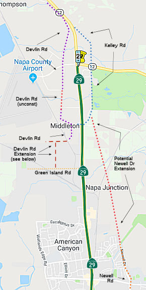
In January 2018, it was reported that American Canyon
was preparing to build the Devlin Road extension. Someday, the road is to
extend 3.5 miles from Green Island Road in American Canyon to Soscol Ferry
Road near Route 29 at the Butler Bridge. Two key sections are missing.
American Canyon is preparing to build the half-mile, southern terminus
from Green Island Road to Middleton Way, complete with a roundabout. That
will connect the city’s Green Island Road Industrial area with the
county’s airport industrial area. The City Council on Jan. 15, 2019
approved the project’s environmental study. The wait is on to bring
out the bulldozers and get to work on what’s expected to be about a
nine-month project -- hopefully by Summer 2019. That will depend in part
on the California Transportation Commission. The city in March 2019 will
ask the state to advance $4.1 million in funding targeted for 2021-22.
Instead of doing an environmental impact report to satisfy state law, the
city completed a less-involved “mitigated negative
declaration” because there are no significant impacts expected. Even
so, this document by GHD consultants tops 300 pages. A single-lane,
140-foot diameter roundabout is to be built at the intersection with a
future road to Napa Logistics Park. This is part of a trend in Napa County
and the state to use roundabouts instead of stop signs or traffic signals
at certain intersections. A new Napa Valley Vine Trail segment is set to
run along the new Devlin Road section. Plans call for an 8-foot-wide bike
path with 2-foot shoulders. That would add another half-mile to a
bike-and-walking path that is to someday extend 47 miles from Vallejo to
Calistoga. The other key gap in Devlin Road is in the unincorporated
county. The county could begin work on this project in Feburary 2019.
(Source: Napa Valley Register, 1/20/2019)
In March 2019, it was reported that American Canyon is
continuing efforts to annex 87 acres on its northeast edge, in part to
someday extend Newell Drive to Route 29 and take some of the city traffic
off the congested highway. This land is north of the planned Watson Ranch,
which is to have 1,250 homes, parks, a hotel, stores, a school and a town
center on almost 300 acres. That kind of expected growth makes the Newell
Drive extension a priority. Newell Drive presently runs from American
Canyon Road north for less than a mile. The goal is to extend the road
about two miles, north past the Watson Ranch property and through the
targeted annexation land, then west to Route 29 near Green Island Road.
“Eventually, Newell Drive will provide a parallel alternative route
on the east side of (Route) 29,” says a recent Local Agency
Formation Commission of Napa County growth study for the area. On March
19, 2019, the American Canyon city council approved a pre-annexation
agreement for the 31-acre Paoli property, which is part of the 87 acres.
Among other things, the owners agree to dedicate right-of-way for Newell
Drive. Land on the Paoli property would be zoned light industrial with a
commercial overlay in parts nearer to Route 29. This development would
help fund a Newell Drive extension. Other properties in the targeted
87-acre annexation area are not to have pre-annexation agreements. Those
are the Watson Lane area, which has rural homes, the 3.8–acre
Gonsalves property and 8.6 acres owned by Union Pacific. More work must be
done to bring the 87 acres into American Canyon borders, such as an
environmental study. A tax-sharing agreement must be reached with Napa
County. Then the city must submit an annexation application to the Local
Agency Formation Commission of Napa County, which decides whether to
approve annexations. Additional costs to move ahead are likely $250,000 to
$350,000, with a proportional share to be paid by the Paoli landowners
after annexation, a city report said. The city’s upcoming 2019-20
budget will need to include the upfront expenses to move ahead with the
annexation application. The American City Council directed staff to begin
work on the 87-acre annexation project in September 2017.
(Source: Napa Valley Register, 3/27/2019)
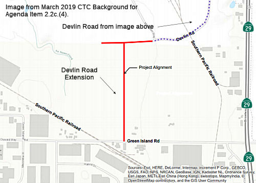 In March 2019, the CTC approved for future consideration
of funding a project that will construct a 0.58-mile extension to Devlin
Road, including the installation of municipal utilities and a segment of
the Napa Valley Vine Trail.
In March 2019, the CTC approved for future consideration
of funding a project that will construct a 0.58-mile extension to Devlin
Road, including the installation of municipal utilities and a segment of
the Napa Valley Vine Trail.
(Source: March 2019 CTC Minutes, Agenda Item 2.2c.(4))
In April 2019, it was reported that there are a number
of changes target for Route 29. By the end of 2019, Caltrans intends to
have what it calls an “adaptive signal control project” up and
running. Five Route 29 traffic signals in American Canyon will be tied
into the Caltrans District 4 Traffic Management Center in Oakland,
Caltrans officials said. Changes to signal timing will be made according
to real-time traffic conditions using algorithms. There is also an
upcoming Route 29 Comprehensive Multimodal Corridor Plan. That plan is
needed for American Canyon highway projects to tap into funding from the
state Senate Bill 1 fuel and vehicle tax hikes. The Multimodal Corridor
Plan could include better crosswalks, more convenient bus stops,
improvements along parallel corridors and bike-and-walking paths. The idea
from the 2014 Route 29 Gateway Corridor Improvement Plan of expanding
Rolute 29 from four lanes to six lanes in American Canyon – three
lanes running in each direction – isn’t in the mix due to
several significant problems. For example, many potential highway
improvement funding sources don’t pay for expanding capacity.
Caltrans has trouble maintaining its existing infrastructure. Widening a
bridge over Paoli Loop Road and the railroad tracks would be expensive.
One project that might help is improving the connector ramp from eastbound
Route 12 through Jameson Canyon to eastbound I-80 near Fairfield. Turning
this one-lane connector ramp into a two-lane ramp would help remove a
rural Jameson Canyon afternoon rush-hour bottleneck. That, in turn, might
encourage more I-80-bound drivers to take Route 12 through Jameson Canyon
instead of Route 29 through American Canyon. Construction of the improved
Route 12/I-80 ramp is to begin in summer of 2020, according to the Solano
Transportation Authority. Lastly, there is the project to finish off
Devlin Road. The city and Napa County are taking the final steps to
complete this 3.5-mile parallel route from American Canyon to Route 29
near the Grapecrusher statue. American Canyon had sought to begin
construction this summer on the half-mile segment between Middleton Way
and Green Island Road. Work would finish in 2020. That hinged on the
California Transportation Commission (CTC) advancing $4.1 million in state
funds scheduled to be released for the project in 2021-22. After talking
with CTC staff, American Canyon has decided to seek a shorter advance that
will allow construction to begin in 2020, but in such a way that takes
advantage of the entire summer construction season. This could still allow
the project to finish by the end of 2020. However, a completed Devlin Road
parallel route also raises a question. The American Canyon general plan
shows a link ultimately being made from Devlin Road to residential areas a
short distance away, creating American Canyon’s long-planned west
side connector. But a west side connector is controversial. Some residents
fear it will increase the number of motorists fed up with Route 29
congestion who seek traffic relief by driving through their neighborhoods.
(Source: Napa Valley Register, 4/4/2019)
In July 2019, it was reported that a lawsuit claims
American Canyon’s ideas to transform car-centric Broadway (Route 29)
into a pedestrian-and-cyclist-friendly main drag with more residences and
businesses has flaws that need mending. City officials at a June 18 City
Council meeting praised the Broadway District Specific Plan. They talked
about creating over two decades a coherent, appealing look amid what is
now a hodgepodge of highway-fronting developments and vacant lots. But
Davis-based California Clean Energy Committee claims the Broadway plan
vision would generate too much traffic and provide too little affordable
housing. It wants a Napa County Superior Court judge to tell the city to
do more work on the project’s environmental impact report. American
Canyon wants to widen Route 29 from two lanes each direction to three
lanes and to lower the speed limit from 55 mph and 50 mph to 35 mph. Lower
speeds would allow for narrower lanes. Features such as landscaped medians
would be added.
(Source: Napa Valley Register, 7/16/2019)
In February 2020, another Devlin Road segment was
scheduled to open, providing a new link in the still-evolving, south
county parallel route to congested Route 29. The segment is 1,100 feet, a
distance equal to three football fields, and includes a bridge over Fagan
Creek. It will allow drivers in the airport industrial area to drive
between Airpark Road and Tower Road. Combined with existing county Devlin
Road segments, this latest addition will offer an option for people
heading to the Devlin Road Recycling and Transfer Facility to get rid of
their trash. Devlin Road is to ultimately stretch 3.5 miles from Soscol
Ferry Road near the Grape Crusher statue to Green Island Road in American
Canyon. Over several decades, it has been built in spurts, creating a
puzzle with missing pieces. This parallel road will provide a previously
non-existent alternative to Route 29, with the dual purpose of providing
congestion relief and alternative emergency access. American Canyon is to
build a final, half-mile segment between Green Island Road and an existing
segment that dead-ends. Work on the $8.5 million project should begin in
Summer 2020, with about half of the cost being paid by state funds and the
remainder by a combination of local impact fees.
(Source: Napa Valley Register, 2/26/2020)
In June 2020, it was reported that American Canyon is
using eminent domain to acquire several slivers of private property it
deems necessary for the Green Island Road project in the industrial area.
City officials said the step is necessary to keep the $14 million Green
Island Road project on schedule. Negotiations for land acquisitions and
temporary construction easements in these four cases have reached
impasses. The industrial area with 60 businesses and more than 1,200
employees is served by a main road marred by rough patches. City officials
said that, on a scale of 1 to 100 with 100 being best, Green Island Road
has a pavement quality score of 12. For context, the Metropolitan
Transportation Commission considers any score below 24 as failure. Such a
road has extremely rough pavement and needs complete reconstruction, not a
mere patch job. To remedy the situation, the city this year is launching a
drive to reconstruct 1.9 miles of Green Island Road, Jim Oswalt Way,
Mezzetta Court, Hanna Drive and Commerce Boulevard. That includes a wider
Green Island Road with a two-way center turn lane and underground
utilities.
(Source: Napa Valley Register, 6/4/2020)
In September 2020, it was reported that Caltarns plans
to enable an adaptive traffic signal system that will use cameras and
sensors to adjust timing at five consecutive signals to best handle
real-time traffic conditions. The signals are at American Canyon Road,
Donaldson Way, Rio Del Mar, Eucalyptus Drive and Napa Junction Road. The
new system goes beyond synchronized traffic signals, which can be found in
many places. Synchronized systems have preset patterns based on traffic
studies, while the American Canyon system will adapt to conditions as they
happen. The NVTA’s recently released Route 29 Comprehensive
Multimodal Corridor Plan calls for $368 million in improvement along Route 29 from Imola Avenue in the city of Napa through American Canyon. Within
American Canyon, the plan calls for such things as bus lanes near
intersections to give buses a jump on traffic and for multi-use paths. A
pedestrian crossing structure could be built at American Canyon Road. The
2014 proposal to widen Route 29 from four lanes to six lanes is gone.
Local officials have said the trend for funding highway capacity-adding
projects is creating toll express lanes instead.
(Source: Napa Valley Register, 9/10/2020)
In March 2021, it was reported that the 25 year Napa
County Transportation Plan championed widening Route 29 through that city
from four lanes to six lanes. The project is in the draft Advancing
Mobility 2045 at $26 million as phase two for this roadway stretch, coming
after such things as intersection reconfigurations. However,
transportation officials have said securing funding for a
capacity-expanding project could be difficult. Caltrans is not favoring
such projects. The NVTA did computer traffic modeling for Advancing
Mobility 2045. Results showed that improving mass transit and
bike-and-pedestrian facilities would do more to ease traffic problems
countywide than widening Route 29 to six lanes in American Canyon..
(Source: Napa Valley Register, 3/28/2021)
In May 2022, it was reported that the Devlin Road
project was nearly done. This is the part that makes the Green Island Road
connection. Without this segment, a Route 29 closure near American Canyon
means taking a 16-mile detour. Drivers use I-80 and Route 12 through
Jameson Canyon, going into Solano County for much of the trip. Dumping all
of the Route 29 traffic onto an already-congested route means extreme
congestion. The days of the long detour will soon be over — unless
the Route 29 closure is just south of the Green Island Road entrance.
There is still a one-third mile stretch of highway with no linking,
parallel surface road. Whether drivers would want to take all 4 miles of
Devlin Road on a regular basis to try to avoid Route 29 traffic is yet
another question. The road at one point is almost a mile to the west of
the more direct highway route. The northern entrance to the new Devlin
Road segment is a 140-foot-diameter roundabout designed for truck traffic.
It is the largest roundabout in Napa County.
(Source: Napa Valley Register, 5/25/2022)
In May 2023, it was reported that American Canyon is
working on an environmental impact report for its proposed Paoli/Watson
Lane annexation. This land is east of Route 29 near Paoli Loop Road. The
proposed annexation would allow a Newell Drive extension to connect with
the highway. The city intends to extend Newell Drive as a parallel roadway
to Route 29 to relieve traffic congestion, according to the draft
environmental impact report. Specifically, Newell Drive is to someday run
for about 2.5 miles from American Canyon Road to Route 29. It would allow
drivers on the east side of Route 29 to traverse American Canyon without
using the highway. The first mile of Newell Drive has for years existed
from American Canyon Road going north to near the Newell Open Space
Preserve. Now the road is being extended through the Watson Ranch
development. Annexing the Paoli/Watson Lane land allows for the final
piece: the connection to Route 29 near Green Island Road. Although there
are no cost estimates, the proposed road extension has some expensive
features. Taking Newell Drive over the Paoli/Watson Lane land along the
preferred route would include constructing two bridges. One would pass
over railroad tracks, the other over North Slough. An alternative
mentioned in the draft environmental report is to extend Newell Drive in
this area using existing Watson Lane. This route might have an at-grade
rail crossing instead of a bridge and would avoid North Slough. Another
alternative is to extend Newell Drive still farther north, connecting it
to South Kelly Road, where drivers could then reach both Route 29 and
Route 12. However, that alternative requires land in the unincorporated
county, outside the city’s jurisdiction and control. The draft
report lists 34 mitigations that it said would reduce the environmental
impacts of the annexation to “less than significant” levels.
Mitigations range from blocking development within 50 feet of North Slough
to requiring all-electric buildings. American Canyon will prepare a final
environmental impact report that responds to comments on the draft
version. The city cannot annex the land on its own, as the Local Agency
Formation Commission of Napa County would have to grant approval.
(Source: $ Napa Valley Register, 5/2/2023)
Soscal Flyover/Junction (~ NAP 5.702 to NAP 10.333)
In February 2014, the Napa County Transportation and
Planning Agency provided updated results from the study. The draft Route 29 Gateway Corridor Improvement Plan calls for expanding the highway from
four to six lanes from American Canyon Road to Route 12/Jameson Canyon, as
well as new interchanges at Route 12/Jameson Canyon and Route 221 and
improvements to the juncture of Route 29 and Route 12/Carneros Highway. In
American Canyon, the two new lanes would be built as frontage roads to
siphon off local traffic from the highway. The plan also adds miles of
bicycle paths and sidewalks, and a link to the future Vine Trail multi-use
path that’s planned to run from Calistoga to the Vallejo Ferry. The
character of the 17-mile stretch of roadway (from the Vallejo ferry to
Trancas Street in Napa) would transition from landscaped freeway to
“boulevard” in American Canyon to rural highway further north
to align with the residential, commercial and undeveloped surroundings.
(Source: American Canyon Eagle)
In October 2014, Napa County Transportation and
Planning Agency voted to accept the Gateway Corridor Improvement Plan -- a
$349 million plan to improve Route 29 in south Napa County. This plan
would include having six lanes in American Canyon, building a Soscol
flyover at Route 221 and reconfiguring lanes at the Sonoma County turnoff.
The plan also calls for giving Route 29 a look and character in keeping
with the areas it passes through, be it rural or city. Out of the various
projects included in the plan, a $48 million Soscol flyover at Route 221
near the Butler Bridge is listed as a priority. That’s because this
proposal, which has been around for years, is closest to having
environmental work completed, the plan says. An elevated ramp would take
southbound Route 221 traffic to southbound Route 29 and a new connector
ramp would take southbound Route 221 traffic to northbound Route 29.
Soscol Ferry Road would be limited to right turns in and right turns out.
The traffic signal would be eliminated. Another project would turn Route 29 from a four-lane road to a six-lane road through central American
Canyon. Landscaping, a bike path and safety improvements for pedestrians
would be added. The estimated cost is $25.5 million. The plan also
considers keeping Route 29 four lanes through American Canyon and adding
such improvements as lanes for local traffic separated from the highway by
a landscape strip. This concept acknowledges that American Canyon uses the
road as a Main Street, but that the six-lane option does more to ease
traffic congestion. The state Department of Transportation plans to hold a
meeting in December 2014 to open the 30-day comment period on the draft
environmental report. No money is available yet for construction.
(Source: Napa Valley Register, 10/16/2014)
 In April 2016, it was reported that the proposed Soscol Junction flyover at Route 29 (NAP
R6.168) and Route 221 southeast of the grape crusher statue might become
the proposed Soscol Junction roundabouts. Although the $40 million flyover
joining southbound Route 221 to southbound Route 29 remains the preferred
option to unsnarl the rush-hour backups caused by traffic signal red
lights at this key intersection, Caltrans will allow the Napa Valley
Transportation Authority and city of Napa to spend a few month exploring
whether a double-roundabout design could handle the traffic. The
roundabouts would be on either side of Route 29 and serve as the onramps
and offramps. They would also allow traffic to take a road passing under
or above Route 29 as a link between Route 221 and Soscol Ferry Road. NTVA
will spend about $40,000 studying the roundabouts option, with the city of
Napa providing the engineering work.
In April 2016, it was reported that the proposed Soscol Junction flyover at Route 29 (NAP
R6.168) and Route 221 southeast of the grape crusher statue might become
the proposed Soscol Junction roundabouts. Although the $40 million flyover
joining southbound Route 221 to southbound Route 29 remains the preferred
option to unsnarl the rush-hour backups caused by traffic signal red
lights at this key intersection, Caltrans will allow the Napa Valley
Transportation Authority and city of Napa to spend a few month exploring
whether a double-roundabout design could handle the traffic. The
roundabouts would be on either side of Route 29 and serve as the onramps
and offramps. They would also allow traffic to take a road passing under
or above Route 29 as a link between Route 221 and Soscol Ferry Road. NTVA
will spend about $40,000 studying the roundabouts option, with the city of
Napa providing the engineering work.
(Source: Napa Valley Register, 4/23/2016)
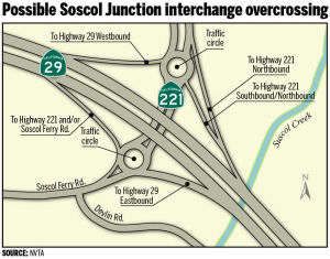
The 2018 STIP, approved at the CTC March 2018 meeting, appears to change the allocation for this project from $6.3M to $12.819M (Caltrans + Napa TPA), with R/W acquisition and PS&E occuring in FY19-20. This project is at the intersection of Route 12, Route 29, and Route 221. Partial grade separation improvements
In August 2018, it was reported that Caltrans and the
Napa Valley Transportation Authority were looking for opinions on the
particular roundabout approach to take at Soscol Junction. The issue is:
one large roundabout or two smaller ones. No roundabouts would be on Route 29 itself. The highway would rise up on an overpass, no longer burdened
with the traffic signals that cause long backups. Underneath the overpass
is where the roundabout or roundabouts would be. They would control
traffic as it enters Route 29 either northbound or southbound or travels
between Soscol Ferry Road and Route 221. California created Soscol
Junction in 1981 as part of its Southern Crossing project when it opened
the nearby Butler Bridge for Route 29. Before that, highway traffic
traveled up the east side of the Napa Valley, took Imola Avenue west and
then continued on to Sonoma County or Upvalley. The original idea in the
1970s was to have an interchange from the start at Soscol Junction. But
money for the project proved tight and transportation officials settled
for the cheaper solution of traffic signals. By 2002, Napa County
officials were talking about the flyover solution. Now the idea has turned
into roundabouts, with the two possible configurations.
(Source: Napa Valley Register, 8/19/2018)
In October 2019, it was reported that a steep rise in
the estimated cost for the proposed, congestion-busting Soscol Junction
project isn’t sinking building plans. The estimated price has risen
from $40 million to $64 million. Napa Valley Transportation Authority
Executive Director Kate Miller said the plan is still to break ground in
2021. The longer Soscol Junction is delayed, the more the project will
cost, an agency report said. Soscol Junction is the intersection of Route 29 and Route 221/Soscol Ferry Road east of the Butler Bridge and
Grapecrusher statue. The plan is to raise Route 29 on an overpass and
remove the traffic signals so traffic keeps flowing. Route 221/Soscol
Ferry Road beneath the overpass would have two roundabouts to regulate
through traffic and traffic entering and leaving Route 29. Route 29 would
not have a roundabout. NVTA for several years has listed a price estimate
of $35 million to $40 million. A new report pegs it at $64 million, with
$50 million needed for construction. The project has been in the
environmental phase for years and construction costs rise 3 percent to 6
percent annually. Caltrans recently released the draft environmental
document, so that phase is nearing an end. Additionally, competition for
construction engineering companies that do this type of work is adding to
the estimated cost. The NVTA Board of Directors last week authorized
Miller to seek a $20-million advance in regional transportation
improvement program money for Soscol Junction. This state money comes to
the county in two-year cycles for local transportation projects. The 2020
cycle has $2 million available for new projects. Napa County would tie up
several cycles of funding. It would forgo using this money source for
other, smaller transportation projects for years to come in exchange for
the large, signature Soscol Junction project. Another potential Soscol
Junction funding source is regional state bridge toll hikes approved by
voters in 2018, though this money is frozen because of a court case
challenging the increases. Still another possible source is a grant
related to 2017’s Senate Bill 1, which raised state fuel taxes and
vehicles fees.
(Source; Napa Valley Register, 10/30/2019, updated 11/6/2019)
In March 2020, the CTC approved for future
consideration of funding a project on Route 29 (04-Nap-29, PM R5.6/R6.7)
and Route 221 (04-Nap-221, PM 0.0/0.4) in Napa County. Reconfigure an
existing intersection in Napa County. (PPNO 0376). This project is located
on Route 29 and Route 221 in Napa County and proposes to reconfigure the
existing intersection (Soscol Junction) of Route 29 and Route 221/Soscol
Ferry Road in Napa County from a signalized intersection to a full-diamond
interchange, with two roundabout intersections on either side of Route 29.
This proposed project is to improve traffic operations to alleviate
congestion between Napa Valley and towards Interstate I-80 and Route 37.
This project is not fully funded; it is currently programmed in the 2018
STIP for $12,819,000 in regional shares for various components.
Construction is estimated to begin in 2022. The scope, as described for
the preferred alternative, is consistent with the project scope programmed
by the Commission in the 2018 STIP.
(Source: March 2020 CTC Agenda, Agenda Item
2.2c.(1))
In March 2020, the CTC approved the 2020 STIP, which
increased the programmed funding for PPNO 0376 Rt 12/29/221 Soscol
intersection separation (SB1), from $9,819K to $29,819K, with the bulk
being in FY21.22.
(Source: March 2020 CTC Agenda, Item 4.7, 2020 STIP
Adopted 3/25/2020)
In December 2020, it was reported that the CTC approved
a $25 million allocation through the Solutions for Congested Corridors
program to complete a $64 million funding package and begin construction
in 2021 of a double roundabout at the Soscol Junction of Route 29 and
Route 221 south of Napa. The improvements will relieve a traffic
bottleneck that has long bedeviled residents, workers and tourists to
Napa’s famous wine region, and will also deliver important safety
and active transportation benefits to the area.
(Source: The Bay Link, 12/3/2020)
In June 2021, the CTC approved amending the STIP to use
the funding available through the 2021 Mid-Cycle STIP and share
distribution of the federal Coronavirus Response and Relief Supplemental
Appropriations Act of 2021 funds (COVID Relief Funds) to increase funding
for a project already in the STIP as follows: Route 12/Route 29/Route 221
Soscol Junction Intersection Separation Project (PPNO 0376); program $739K
to the CON Support phase in FY 2021-22.
(Source: June 2021 CTC Agenda, Agenda Item
2.1a.(19))
In October 2021, the CTC approved the following
State-Administered multi-funded STIP/SB 1 Solutions for Congested
Corridors Program (SCCP)/Local Partnership Program (LPP) (Formulaic)
allocation/amendment: $49,580,000. 04-Nap-29 5/6.7. PPNO 04-0376;
ProjID 0400000769; EA 28120. Soscol Junction (Route 29/Route 221/Soscol
Ferry Road). On Route 29 at Route 221 In Napa County. Operational
improvement located at the intersection of Route 29/Route 221/Soscol Ferry
Road. Allocation:COVID RIP/21-22 ⇛ CON ENG $739,000. SCCP/21-22
⇛ CONST $25,000,000. LPP-F/21-22 ⇛ CON ENG $422,000. RIP/21-22
⇛ CON ENG $864,000; CONST $23,419,000 $22,555,000.
(Future consideration of funding approved under Resolution E-20-15; March
2020.) (Contribution from other sources: $3,714,000 for CON ENG)
(Source: October 2021 CTC Agenda, Agenda Item
2.5s.(7)/2.5v.(5))
In June 2022, it was reported that the groundbreaking
for this project had taken place for the $54 million Soscol Junction
construction project at the entrance to Napa Valley. The project will
elevate Route 29, and create two roundabouts underneath to regulate Route 221 and Soscol Ferry Road traffic. The roundabouts will control traffic
getting on and off the highway. This is similar to what was done for the
intersection of I-80 and Route 89 near Truckee. Commuters and drivers over
the next two years or so can expect constant change at Soscol Junction.
Initial steps include putting a concrete K-rail in the median and
shoulders to protect workers and doing stormwater work, according to
Ghilotti Construction Co. Following this will be a series of traffic
shifts, lane closures, ramp closures and detours as the project winds
through five stages with numerous sub-stages. The main thrust of Route 29
traffic should keep moving. But various connections between Route 29,
Route 221, and Soscol Ferry Road will be closed at times, often during
non-peak traffic hours. Drivers might find themselves going through the
nearby business park and airport industrial area. Instead of making a
quick turn at the intersection, they’ll take an off-the-beaten-track
side trip. Peak delay for extended closures is estimated to be less than
10 minutes. Caltrans will inform the public as each stage and sub-stage
brings about specific ramp and lane closures.
(Source: $ Napa Valley Register, 6/22/2022; $ 9Nc--20C3KbDAuPoHhLkjqYWlB6tDkrOifTG9kqBnScdrY">Napa Valley Register, 7/28/2022)
In July 2023, it was reported that in June 2023 MTC
last month formally approved the first allocations of Regional Measure 3
dollars, releasing over $270 million for nine projects for which the
sponsors already were moving ahead under Letters of No Prejudice. These
initial allocations included: Napa Valley Transportation Authority: $20
million for upgrades to the Route 29 Soscol Junction near Napa.
(Source: MTG/ABAG Bay Link Blog, 7/12/2023)
In August 2023, it was reported that construction has
started on the key Soscol Junction bridge at the entrance to Napa Valley
on Route 29. This bridge will carry Route 29 traffic over Route 221,
eliminating a traffic signal. Two giant roundabouts are being created
below the bridge to regulate traffic getting on and off Route 29. Napa
County’s biggest transportation project in a decade is rapidly
taking shape before a captive audience of commuters and travelers.
Caltrans officials say motorists could be driving on a finished, $54
million Soscol Junction by mid-2024. Motorists won't have to wait until
the completion of Soscol Junction to get to use the bridge. Northbound
traffic is scheduled to be shifted onto the structure in December.
Southbound lanes could shift to the bridge early in 2024. As for the
roundabouts, they should be fully open to motorists in spring or summer
2024, with partial openings to allow the use of new Route 29 on-ramps in
fall 2023.The traffic signal will be removed when the roundabouts are
fully opened. The ultimate plan is to someday create an interchange at the
Route 29 and Route 12 entrance to Jameson Canyon as well. But money must
be found for what amounts to another Soscol Junction-scale project.
(Source: Napa Valley Register, 8/9/2023)
In November 2016, it was reported that Caltrans will be out with cranes
and other equipment installing new, highly reflective signs along Route 29
in and near the city of Napa. Locations includes stretches of Route 29 and
various ramps from Route 12 near Napa County airport (29 NAP 4.693) north
to Trower Avenue (29 NAP 13.848) nine miles away.
(Source: $ Napa Valley Register, 11/5/2016)
Carneros Junction Improvements (29 NAP R8.615)
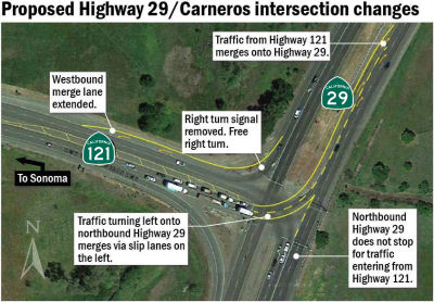 In July 2017, a new proposal emerged for the Carneros
Junction (29 NAP R8.615): Where Route 29 meets Route 12/Route 121. No
massive interchange is proposed to replace traffic signals at the
T-intersection for Napa and Sonoma flows. Instead, the three-year-old idea
is to add merge lanes, give some lanes a constant green light and reap a
little congestion relief. The NVTA took a close look at the Carneros
intersection in its 2014 Highway 29 Gateway plan. This study concluded an
interchange with on-ramps and off-ramps is the ultimate solution, but that
such a structure would be costly and could have big environmental impacts.
One alternative is building the Carneros interchange roundabout, either
with or without traffic signals. This wouldn’t make a big
congestion-easing difference in the long run, the plan concluded. That
leaves the $1 million idea to ease congestion on the (relative) cheap.
Northbound Route 29 traffic presently stops at a red light when Route 121
traffic coming from the Sonoma direction turns left toward Napa. The
proposed change – have northbound traffic always flowing through the
intersection. And what happens when the Highway 121 traffic makes a left
turn in front of it? A long merge lane would be created so these divergent
traffic streams have space to come together. The same concept would be
used so southbound Route 29 traffic turning right onto Route 121 toward
Sonoma could always have a green light. A long merge lane would be the
buffer when northbound Route 29 traffic makes a left turn onto Route 121.
This proposed project wouldn’t necessarily make Carneros
intersection a motorist’s paradise. There would still be a red light
during the southbound Route 29 morning commutes. The bigger, more
expensive project for the more congested Soscol Junction a few miles south
along Route 29 remains the NVTA’s priority. The agency and Caltrans
are working on that project’s environmental impact report. Still,
the smaller Carneros intersection project is at least in the
agency’s sights, even if there is no timeline to build it and no
state-required environmental report has yet been launched. If all had gone
as planned in the 1970s, both the Carneros and Soscol Junction
intersections would already be interchanges today. Caltrans during that
decade was figuring out the huge Southern Crossing project. Route 29 at
that point went north on Route 221 and then cut across the valley on Imola
Avenue. Route 29 then continued north up Napa Valley and Route 121 went
west to Sonoma. All of that led to congestion near Napa State Hospital and
on Imola Avenue. Caltrans and county officials wanted a Southern Crossing
bridge – today’s Butler Bridge – so Route 29 could
bypass the city of Napa several miles to the south. The Southern Crossing
project approved in 1974 included interchanges at both entrances. But in
1975, state transportation officials pleaded poverty and proposed
installing traffic signals instead. The state would return to build
interchanges “when traffic warrants them.” By 1977, the state
didn’t even have money to connect Route 29 to the bridge it was
already building over the Napa River. County officials went from worrying
about having interchanges to keeping the Southern Crossing from becoming a
bridge to nowhere. In 1981, the state finally opened the several miles of
connecting highway that made the Butler Bridge part of Route 29. But the
interchanges had dropped from the plans, replaced by the traffic signals.
In July 2017, a new proposal emerged for the Carneros
Junction (29 NAP R8.615): Where Route 29 meets Route 12/Route 121. No
massive interchange is proposed to replace traffic signals at the
T-intersection for Napa and Sonoma flows. Instead, the three-year-old idea
is to add merge lanes, give some lanes a constant green light and reap a
little congestion relief. The NVTA took a close look at the Carneros
intersection in its 2014 Highway 29 Gateway plan. This study concluded an
interchange with on-ramps and off-ramps is the ultimate solution, but that
such a structure would be costly and could have big environmental impacts.
One alternative is building the Carneros interchange roundabout, either
with or without traffic signals. This wouldn’t make a big
congestion-easing difference in the long run, the plan concluded. That
leaves the $1 million idea to ease congestion on the (relative) cheap.
Northbound Route 29 traffic presently stops at a red light when Route 121
traffic coming from the Sonoma direction turns left toward Napa. The
proposed change – have northbound traffic always flowing through the
intersection. And what happens when the Highway 121 traffic makes a left
turn in front of it? A long merge lane would be created so these divergent
traffic streams have space to come together. The same concept would be
used so southbound Route 29 traffic turning right onto Route 121 toward
Sonoma could always have a green light. A long merge lane would be the
buffer when northbound Route 29 traffic makes a left turn onto Route 121.
This proposed project wouldn’t necessarily make Carneros
intersection a motorist’s paradise. There would still be a red light
during the southbound Route 29 morning commutes. The bigger, more
expensive project for the more congested Soscol Junction a few miles south
along Route 29 remains the NVTA’s priority. The agency and Caltrans
are working on that project’s environmental impact report. Still,
the smaller Carneros intersection project is at least in the
agency’s sights, even if there is no timeline to build it and no
state-required environmental report has yet been launched. If all had gone
as planned in the 1970s, both the Carneros and Soscol Junction
intersections would already be interchanges today. Caltrans during that
decade was figuring out the huge Southern Crossing project. Route 29 at
that point went north on Route 221 and then cut across the valley on Imola
Avenue. Route 29 then continued north up Napa Valley and Route 121 went
west to Sonoma. All of that led to congestion near Napa State Hospital and
on Imola Avenue. Caltrans and county officials wanted a Southern Crossing
bridge – today’s Butler Bridge – so Route 29 could
bypass the city of Napa several miles to the south. The Southern Crossing
project approved in 1974 included interchanges at both entrances. But in
1975, state transportation officials pleaded poverty and proposed
installing traffic signals instead. The state would return to build
interchanges “when traffic warrants them.” By 1977, the state
didn’t even have money to connect Route 29 to the bridge it was
already building over the Napa River. County officials went from worrying
about having interchanges to keeping the Southern Crossing from becoming a
bridge to nowhere. In 1981, the state finally opened the several miles of
connecting highway that made the Butler Bridge part of Route 29. But the
interchanges had dropped from the plans, replaced by the traffic signals.
(Source: Napa Valley Register, 7/15/2017)
Napa - First, Second, and California Street Connection Improvements (~ NAP 11.432)
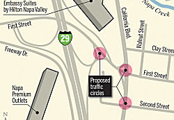 In May 2016, it was reported that the City of Napa was considering a conceptual plan to build three traffic circles joining
California Boulevard, First and Second Streets, and Route 29 (approx NAP
11.432). The roundabouts would control traffic flow from the freeway and
California onto the two major east-west routes into downtown, which also
would have their directions reversed; First would channel eastbound
vehicles while Second would carry drivers toward the highway. The plan
combines improvements earlier sought by the city and Caltrans, which
agreed to use a rotary instead of a traffic light for its redesign of the
Route 29 interchange with First.
In May 2016, it was reported that the City of Napa was considering a conceptual plan to build three traffic circles joining
California Boulevard, First and Second Streets, and Route 29 (approx NAP
11.432). The roundabouts would control traffic flow from the freeway and
California onto the two major east-west routes into downtown, which also
would have their directions reversed; First would channel eastbound
vehicles while Second would carry drivers toward the highway. The plan
combines improvements earlier sought by the city and Caltrans, which
agreed to use a rotary instead of a traffic light for its redesign of the
Route 29 interchange with First.
(Source: Napa Valley Register, 5/16/2016)
In June 2016, the CTC approved for future consideration of funding a project that will construct a roundabout at First Street/California Boulevard and Second Street/California Boulevard, and will reverse the one-way couplet of First and Second Streets. A second roundabout will be constructed at the Northbound Off-ramp of Route 29 and First Street. On May 17, 2016, the City adopted the final MND for the project and found that the project will not have a significant effect on the environment after mitigation. Impacts that require mitigation measures to be reduced to less than significant levels relate to biological resources, hazardous materials, cultural resources and noise abatement. Mitigation measures include, but are not limited to: require revegetation strategies to be included in the final specifications, conduct nesting surveys, require the consultation of a qualified archaeologist if cultural materials are unearthed and limit construction activities to reduce noise levels from 7:00 AM to 7:00 PM. The project is estimated to cost $11,942,000 and is fully funded through construction with State Highway Operation and Protection Program (SHOPP) Funds ($5,454,000), Local Funds ($2,524,000), Congestion Mitigation and Air Quality Improvement (CMAQ) Funds ($2,463,000) and Regional Improvement Program (RIP) Funds ($1,501,000). Construction is estimated to begin in Fiscal Year 2016/17.
The following project was included in the final adopted 2018 SHOPP in March 2018: PPNO 1488P. 04-Napa-29 11.4. Route 29 In Napa, at northbound ramps and 1st Street. Construct roundabout. Begin Con: 2/22/2019. Total Project Cost: $6,950K.
In September 2018, it was reported that starting in
October 2018 and continuing for just over a month, a contractor will
remove about 60 trees in the vicinity of First Street and California
Boulevard, according to Eric Whan, Napa’s interim public works
director. The removals will clear space needed to start demolition and
grading for construction of three traffic hubs that will connect Route 29
with First and Second streets and California Boulevard, eliminating
traffic signals at an interchange that funnels visitors into central Napa.
Construction of the roundabouts is scheduled to begin in spring 2019 and
last 18 to 20 months, with the new traffic pattern going into service by
the end of 2020, said Whan. The project also will reverse the one-way flow
of First and Second streets, carrying motorists leaving Route 29 eastbound
onto First Street into downtown and channeling westbound vehicles onto
Second Street toward the freeway and the Browns Valley area. Capping the
roundabout project will be a re-landscaping of the streets connected to
Route 29. That phase will include planting 73 new trees and 2,489 shrubs
and smaller plants, according to senior civil engineer John Ferons. When
complete, the traffic realignment – jointly designed by Napa and
Caltrans and estimated to cost $6 million – is meant to improve
driver safety and relieve congestion to and from four-lane Route 29.
Rotary hubs will replace the freeway’s interchange with First Street
as well as the First-California and California-Second intersections.
Drivers will pass through the roundabouts counterclockwise in a pattern
intended to keep traffic flowing slowly but steadily, reducing the chances
of dangerous broadside collisions. With the reversal of one-way traffic on
First and Second streets, motorists currently leaving the freeway will no
longer follow First south to California before turning left on Second, but
take two circles to continue east on First. Those who take Second on their
way out of downtown will pass through all three circles en route to Route 29 or neighborhoods in west Napa.
(Source: Napa Valley Register, 9/30/2018)
In June 2019, it was reported that transportation
officials have broken ground on what will be roundabouts at First
Street/Route 29, First Street/California Boulevard and California
Boulevard/Second Street. Before the roundabouts come the workarounds.
Since these are major roads, the plan is to keep traffic moving through
the construction zone as intersections are transformed. Construction will
initially focus on the roundabout targeted for the northbound Route 29
entrance and exit at First Street. Drivers next week might see flagging
and traffic shifts while workers do such things as remove a median,
transportation officials said. Then drivers for a year or so will see
traffic lane configuration shifts, concrete K-rails and the occasional
delay as big equipment moves around. They’ll be driving emerging
roundabouts before the entire project is finished. The roundabout project
also calls for First Street and Second Street between California Boulevard
and Jefferson Street to switch their one-way directions. This should take
place about halfway to two-thirds into the project, transportation
officials said. Construction crews are to complete the $11.4 million
project between late spring and fall of 2020, depending on weather. O.C.
Jones & Sons is the contractor.
(Source: Napa Valley Register, 6/3/2019)
In September 2019, it was reported that as part of the
roundabout construction project, both the northbound Route 29 off-ramp and
loop on-ramp at First Street will be closing for two months in October
2019. The ramps are expected to reopen at the end of November when a
working roundabout should be ready at this location. The roundabout on
First Street at the Route 29 on- and off-ramps should be operational at
the end of November 2019 if things go according to schedule. The
roundabout at First and California should be working by the end of 2019,
with completion of the roundabout at Second and California set for early
2020. When the roundabout at First and California begins carrying traffic,
First and Second streets will be flipped. First between California and
Jefferson Street will carry vehicles into downtown while Second carries
them out.
(Source: Napa Valley Register, 9/26/2019)
In November 2019, it appears the first of the new
roundabouts were open, as the City of Napa was advising people on how to
navagate them. Specifically, the roundabout at the First Street/Route 29
juncture opened -- this roundabout will carry motorists east and west on
First and also reopen old connections to Route 29. This is the
western-most roundabout, just below the Route 29 overpass. Another at
First and California Boulevard should open in late December, while a third
at California and Second Street is scheduled for early next year. The
city’s roundabouts are designed for vehicles moving 15 mph.
(Source: City of Napa FB Post, 11/19/2019; NapaValley
Register, 11/19/2019)
In January 2020, it was reported that the freeway
entrance into downtown Napa was changing with the debut of a second
roundabout, combined with the flip of the one-way directions of First and
Second streets between California Boulevard and Jefferson Street. These
are the most significant traffic changes in the downtown area since First
and Second in the business district became two-way in 2014 after being
one-way for over a half century. The planned third roundabout at Second
and California won’t be fully functional until the end of January,
when the connection to California south of Second will reopen. At the end
of January, it was reported that Napa’s roundabout project was
nearing completion, with the third circle at Second Street and California
Boulevard to open to motorists by the end of February. The contractor,
O.C. Jones & Sons, Inc., will first reopen California Boulevard
between Second and Third streets the week of 2/10/2020. This means that,
for the first time since summer 2019, northbound and southbound traffic on
California will be able to proceed across Second and First streets without
a major detour. Once all three roundabouts are working open, motorists can
still expect occasional lane closures as workers complete the
reconstruction of California between Second and Third streets. Then the
entire roundabout zone will get a 2-inch top coat of asphalt and permanent
pavement markings. This should all happen before the end of March 2020.
(Source: Napa Valley Register, 1/4/2020, NapaValley
Register, 1/30/2020)
In June 2015, it was reported that the City of Napa was moving ahead with
a project that would build a proper, paved path along Napa Creek, below
the four lanes of Route 29, at an estimated $600,000 cost (near 29 NAP
11.664). Skirting the creek’s north bank in a U-shaped pattern, the
600-foot-long underpass would connect the south end of Coffield Avenue
west of Route 29 to a future trail section planned to run east to
California Boulevard and D Street. Retaining walls would strengthen the
path and its slope would be kept below 8% to meet federal standards for
wheelchair access. The route of the bike path won City Council approval in
early June 2015. Two Caltrans grants totaling $97,000 will cover most of
the $100,000 design and engineering cost, with construction estimated to
cost $500,000. Although a narrow dirt track currently connects the two
sides of the freeway, a fully finished hard-surface path would remove one
of the stiffest roadblocks to casual cycling.
(Source: Napa Valley Register 6/6/2015)
In September 2011, the CTC approved relinquishment of right of way in the city of Napa along Route 29 on Redwood Road, Trancas Street, California Boulevard, and Permanente Way, consisting of collateral facilities. (approx 29 NAP 13.033)
In December 2017, it was reported that frustrated motorists will
potentially see some traffic improvements along the Route 29 traffic
signal gauntlet of Salvador, Wine Country and Trower avenues (approx 29
NAP 13.852 to 29 NAP 14.61). Changes came earlier in 2017 with a new Napa
Valley Vine Trail segment sandwiched between Route 29 and adjacent Solano
Avenue. Trail users cross Salvador, Wine Country and Trower avenues and
traffic lights were added to help them do so safely. The result: drivers
complained that the new signal timing regime caused them more rush-hour
delays on both Route 29 and Solano Avenue. Noting that Caltrans controls
the traffic signal timing along this highway stretch, city officials
agreed to work with Caltrans and a traffic consultant to see if something
could be done. Caltrans discovered some of the vehicle detection loops in
the pavement needed repairs, city Deputy Public Works Director Eric Whan
said. Those loops are being fixed. The next step is trying out an adjusted
timing pattern for the traffic signals based on simulations and traffic
modeling. The goal is to create the optimum traffic flow and avoid undue
delays for any one direction.
(Source: Napa Valley Register, 12/1/2017)
In March 2021, it was reported that the 25 year Napa County
Transportation Plan includes building a $30 million Route 29 crossing over
Trower Avenue (~ 29 NAP 14.61), which would eliminate bottlenecks at this
signalized intersection.
(Source: Napa Valley Register, 3/28/2021)
In July 2016, it was reported that a local permitted project was adding a
left-turn lane and other improvements N of the City of Napa to serve the
planned Ashes & Diamonds winery. When the project is finished,
southbound Route 29 drivers will have a left-turn lane onto Howard Lane
(near 29 NAP 14.82). They’ll be able to use it to reach not only the
winery-to-be, but the existing Bistro Don Giovanni restaurant and Senza
Hotel. Other changes will include an expanded northbound Route 29
deceleration lane. Vintner Darioush Khaledi, who applied for the Ashes
& Diamonds Winery permit, said the Route 29 project will cost the
winery more than $1 million.
(Source: Napa Valley Register, 7/6/2016)
Oakville Cross Road (~ NAP 22.732) and Rutherford Road/Route 128 (~ NAP 24.592) Roundabouts
In March 2021, it was reported that Napa County was
applying for grants to construct two roundabouts that could be ready for
construction by fall of 2022. These two roundabouts could be built on
Route 29 for a total cost of $11 million. One would be at Oakville Cross
Road (~ NAP 22.732) and the other at Rutherford Road (Route 128) (~ NAP
24.592). On March 17, 2021, the Napa Valley Transportation Authority
(NVTA) Board of Directors approved seeking grant money to build the
projects. Next the agency must convince the Metropolitan Transportation
Commission, which in June 2021 is to dispense money from its Safe and
Seamless Mobility Quick-Strike Program to projects that can be launched
quickly to improve a pandemic-stricken economy and improve safety. The
project is spearheaded by Napa Valley Forward, a pilot program partly
funded by the Metropolitan Transportation Commission to reduce local
traffic congestion. Napa Valley Forward is a collaboration that includes
wine and hospitality employers and the NVTA. The NVTA’s March 17
Zoom-only meeting was the first time the agency has had the proposed
roundabouts on an agenda. No one from the public spoke either in favor or
against the idea. One question has been whether roundabouts would fit at
these intersections, given such constraints as nearby buildings,
vineyards, parking lots, and the Napa Valley Wine Train tracks. The answer
appears to be “yes.” The NVTA has drawings showing how the
roundabouts could be configured, with the shapes not necessarily perfectly
round to minimize the amount of adjacent property needed.
(Source: Napa Valley Register, 3/28/2021)
In August 2021, it was reported that MTC Commissioners
approved $6 million as part of the Napa Valley Forward project for
roundabouts along Route 29 in Napa County as a way to improve safety and
traffic flow. Roundabouts at Rutherford and Oakville roads along Route 29
are the initial focus. In coordination with the Napa Valley Transportation
Authority, MTC began studying different ways to improve traffic along
Route 29 and mini-roundabouts were selected to be studied at Rutherford
and Oakville roads due to the nominal cost, significant safety
considerations, and smaller footprint required to construct the
intersection improvements. A Madison Avenue intersection improvement
is also in preliminary design and the proposed design will be shared soon.
To accelerate the process, NVTA and MTC staff met with property owners who
would be directly impacted by the proposed roundabouts. Two follow up
meetings were held – one with Oakville Winegrowers and one with
businesses near Rutherford Road. Additional public outreach to the
broader community will take place in the fall of 2021. Construction could
begin as soon as October 2022, with work being completed in about two
years.
(Source: The Bay Link, 6/24/2021)
In September 2022, it was reported that the
intersection of Route 29 and Rutherford Road is no longer being mentioned
as a potential place for a roundabout project to start construction in
2023 or 2024. Another proposed roundabout at Route 29 and Oakville Cross
Road remains a possibility. But the Rutherford site has dropped from
contention. Per the MTC, “A roundabout did not fit in that
intersection.”. But the real reason is land: It would require taking
land from the adjoining Rutherford Grill, and the restaurant owners
don’t want that to happen. Rutherford Grill has a landscaped section
at the intersection corner adjacent to its outdoor seating area, and they
felt it wasn't safe. Shifting the footprint of a possible roundabout to
avoid using Rutherford Grill land hasn’t proven feasible. Napa
Valley Wine Train tracks to the west make for a tight fit. Even with the
Rutherford Grill land, preliminary plans showed an oblong-shaped
“compact roundabout.” An option is for a government agency to
take the required Rutherford Grill land by eminent domain, but said
voluntary easements are being sought for the roundabout projects. It is
unlikely that the NVTA or Napa County Board of Supervisors will use
condemnation powers to take the land. Plans for a potential Oakville Cross
Road roundabout remain on track. Opus One winery and Napa Wine Co., which
own land at the intersection corners, are at the table. A possible
alternative to a roundabout is a traffic signal. A draft environmental
report should be done early next year, with construction possibly to start
in early 2024.
(Source: Napa Valley Register, 9/27/2022)
In December 2023, there were updates on two proposed
traffic control features on Route 29 in the heart of Napa Valley wine
country — an Oakville Cross Road roundabout and a Rutherford Road
traffic signal. The two projects have a combined estimated construction
cost of $6 million. Work could begin in summer 2024 and take about 16
months to complete. Studies on the project have been released, including a
109-page environmental study, a 67-page cultural resources study and even
a seven-page construction vibrations study. The conclusion, after looking
at potential California red-legged frog habitat and stormwater runoff and
numerous other factors, is that the two projects, with mitigations, would
have no major environmental impacts. For example, Opus One winery at
Oakville Cross Road would lose less than an acre of vineyard land to make
room for the roundabout. But that’s only .002% of Napa
County’s prime farmland, the environmental study said. A major goal
of the two projects is to improve safety. Drivers seeking to make left
turns from Oakville Cross and Rutherford roads onto Highway 29 presently
must wait for breaks in the highway traffic in each direction. Both
intersections have higher-than-average crash rates compared to similar
intersections, the studies said. From 2018 to 2020, the Oakville Cross
Road intersection had 26 collisions. The Rutherford Road intersection had
22 collisions. None resulted in fatalities. A properly designed Oakville
Cross Road roundabout should slow down traffic and reduce the chances of
the most severe intersection crashes and injuries, the environmental study
said, citing federal studies on roundabouts. Originally, a roundabout and
not a traffic signal had been targeted for the Rutherford Road
intersection. But a roundabout is infeasible without substantial
right-of-way impacts, the study said.
(Source: Napa Valley Register, 12/5/2023)
Yountville through the vicinity of Calistoga (Route 128/Route 29 split near Woodleaf)
In May 2011, the CTC approved relinquishment of right of way in the city of St. Helena along Route 29, between Charter Oak Avenue and 0.1 mile west of Pratt Avenue, consisting of non-motorized transportation facilities, namely sidewalks. (approx 29 NAP 28.316)
Route 29 Channelization Project (~ NAP 25.507 to NAP 28.316)
It was also reported in June 2015 that Caltrans
launched a project to improve safety and shorten travel times in St Helena
and Napa County. This project will widen two-lane Route 29 between Mee
Lane in Napa County (approx 29 NAP 25.507) and Charter Oak Avenue (approx
29 NAP 28.316) in St. Helena. Caltrans and its project partners, including
the Napa County Transportation and Planning Agency, Napa County, the city
of St. Helena and the Napa Valley Wine Train, broke ground on the project
in early June 2015, expect to complete it by early 2017. The road is used
by about 22,000 drivers a day. $19 million from the State Highway
Operations and Protection Program is paying for a major portion of the
improvements. San Rafael-based construction contractor Ghilotti Brothers
is doing the work.
(Source: KRON, 6/10/2015)
In June 2016, it was reported that Caltrans and its
local stakeholders were continuing construction of the Route 29
Channelization Project near St. Helena. This work included roadway
excavation and storm drain installation between Dowdell Lane and Charter
Oak Avenue in the southbound shoulder, as well as sidewalk and curb and
gutter construction between Inglewood Avenue and Charter Oak Avenue in the
southbound shoulder; and Infiltration trench construction in the
southbound shoulder, with locations to be determined.
(Source: Napa Valley Register, 6/20/2016)
In September 2016, it was reported that local
dignitaries and Caltrans representatives gathered for a ceremonial ribbon
cutting celebrating improvements to Route 29. The project included a new
center turn lane to make left turns safer, wider shoulders, new railroad
crossings, new underground utility lines to replace unsightly power poles,
a long-planned traffic signal at Grayson Avenue, and safety improvements
for cyclists. The work took place along three miles at the southern
entrance to St. Helena, from Mee Lane to Charter Oak Avenue. The Route 29
Channelization Project was funded by $16.7 million in federal money set
aside for state highway improvements. The project had been in the works
since 1983, and a portion south of Rutherford was completed in 1998.
However, the northern stretch was delayed by right-of-way issues that took
years of negotiations to resolve. One of the most important components of
the project was putting utility lines underground. Pacific Gas &
Electric poles on the east side of Route 29 were replaced with underground
lines on the west side of the road.
(Source: Napa Valley Register, 9/1/2016)
In the December 2017 Caltrans Mile Marker, it was reported that, as part of the Napa State Route 12 Channelization Project, improvements were made to the railroad crossing at Route 29 and Whitehall Lane (~ NAP 26.143), and the bikeway realigned so that bicyclists cross the railroad tracks in a safer direction. Caltrans also incorporated green pavement marking, striping, raised medians or islands, markers and signs.
Ritchie Creek Bridge No. 21-0057 Replacement (04-Napa-29 PM 33.1)
 The 2020 SHOPP, approved in May 2020, included the
following Mandate item of interest (carried over from the 2018 SHOPP):
04-Napa-29 PM 33.1 PPNO 1464K Proj ID 0416000037 EA 4J990. Route 29 Near
Calistoga, at 0.3 mile south of Bothe-Napa Valley State Park entrance at
Ritchie Creek Bridge No. 21-0057. Replace bridge and provide financial
contributions to improve fish passage barriers at the site for compliance
unit credits towards statewide National Pollutant Discharge Elimination
System (NPDES) permit mandate goals. Programmed in FY21-22, with
construction scheduled to start in November 2022. Total project cost is
$10,276K, with $5,689K being capital (const and right of way) and $4,587K
being support (engineering, environmental, etc.).
The 2020 SHOPP, approved in May 2020, included the
following Mandate item of interest (carried over from the 2018 SHOPP):
04-Napa-29 PM 33.1 PPNO 1464K Proj ID 0416000037 EA 4J990. Route 29 Near
Calistoga, at 0.3 mile south of Bothe-Napa Valley State Park entrance at
Ritchie Creek Bridge No. 21-0057. Replace bridge and provide financial
contributions to improve fish passage barriers at the site for compliance
unit credits towards statewide National Pollutant Discharge Elimination
System (NPDES) permit mandate goals. Programmed in FY21-22, with
construction scheduled to start in November 2022. Total project cost is
$10,276K, with $5,689K being capital (const and right of way) and $4,587K
being support (engineering, environmental, etc.).
(Source: 2020 Approved SHOPP a/o May 2020)
In June 2021, the CTC approved the following SHOPP
amendment: 04-Nap-29 33.1 PPNO 1464K; ProjID 0416000037 EA 04-4J990. Route 20 Near Calistoga, at 0.3 mile south of Bothe-Napa Valley State Park
entrance at Ritchie Creek Bridge № 21-0057. Replace bridge and
provide financial contributions to improve fish passage barriers
at the site for compliance unit credits towards statewide National
Pollutant Discharge Elimination System (NPDES) permit mandate goals. Note:
Increase construction capital and support due to addition of traffic
items, erosion control, temporary creek diversion, extending plant
establishment period, and constructing temporary bridge. Delay project by
one year due to lengthy consultation process with various agencies to
obtain environmental clearance. Update project description as the
Financial Contribution Only (FCO) portion of the project was split out
under project EA 4J99A/PPNO 04-1464R. Con Sup $1,300K 21-22
$1,800K 22-23; R/W Cap $590K 21-22
$590K 22-23; Const Cap $5,099K 21-22 $6,887K
22-23; Total $10,276K $12,564K.
(Source: June 2021 CTC Agenda, Agenda Item
2.1a.(2d) #18)
In August 2021, the CTC approved for future
consideration of funding 04-Nap-29, PM 33.13. Ritchie Creek Bridge
Replacement Project for Fish Passage Improvement. Improve fish
passage conditions at the Route 29 crossing over Ritchie Creek in Napa
County. (MND) (PPNO 1464K) (SHOPP). This project is located on Route 29 on
post mile 33.13 southeast of the city of Calistoga and to the north of the
City of St. Helena in Napa County. The Department proposes to address fish
passage barriers at the Route 29 crossing over Ritchie Creek to obtain
Total Maximum Daily Load compliance unit credits from California State
Water Resources Control Board under the Statewide National Pollutant
Discharge Elimination System permit. This project is currently programmed
in the 2020 SHOPP for a total of $12,564,000, which includes Construction
(capital and support) and Right of Way (support). Construction is
estimated to begin in 2023. The scope, as described for the preferred
alternative, is consistent with the project scope as programmed by the
Commission in the 2020 SHOPP. A copy of the MND has been provided to
Commission staff. The project will result in less than significant
impacts to the environment after mitigation. The following resource
areas may be impacted by the project: biological and cultural
resources. Avoidance and minimization measures will reduce any
potential effects on the environment. These measures include, but are not
limited to, incorporation of habitat substrate vegetation for California
freshwater shrimp into the onsite Habitat Mitigation and Monitoring Plan
prior to construction, as well as establishing environmentally sensitive
area fencing and conducting cultural resource monitoring and data
recovery. As a result, an MND was completed for this project.
(Source: August 2021 CTC Agenda, Agenda Item
2.2c.(1))
In December 2021, the CTC approved the following SHOPP
Support Phase allocation: 04-Nap-29 33.1. PPNO 04-1464K; ProjID
0416000037; EA 4J990. Route 29 Near Calistoga, at 0.3 mile south of
Bothe-Napa Valley State Park entrance at Ritchie Creek Bridge №
21-0057. Replace bridge to improve fish passage barriers at the site
for compliance unit credits towards statewide National Pollutant Discharge
Elimination System (NPDES) permit mandate goals. (Future consideration of
funding approved under Resolution E-21-74; August 2021.) Allocation:
PS&E $1,521,000 ($1,300,000 programmed); R/W SUP $195,000 ($167,000
programmed).
(Source: December 2021 CTC Agenda, Agenda Item
2.5b.(2a) #2)
In May 2015, the CTC approved for future consideration of funding a project in Napa County that will replace the existing Napa River Bridge (Bridge 21-0018, 29 NAP 37.03, dating back to 1919, widened in 1952) in the City of Calistoga. The project is programmed in the 2014 State Highway Operation and Protection Program. The estimated cost is $15,918,000 for capital and support. Construction is estimated to begin in Fiscal Year 2015-16. The scope, as described for the preferred alternative, is consistent with the project scope programmed by the Commission in the 2014 State Highway Operation and Protection Program. The replacement Napa River bridge opened in mid-April 2019, according to a tweet from Caltrans.
Garnett Creek Bridge (NAP 39.08)
In September 2012, it was reported
that plans to replace the decaying Garnett Creek Bridge (Bridge 21-0005,
29 NAP 39.08) on Route 29 are on hold in the face of budget constraints
and opposition from Calistoga residents. The bridge, between Calistoga
city limits and Tubbs Lane, was built in 1902 and is one of a dwindling
number of examples of stone arch bridges built in Napa County in that
period. It is a well-known landmark and is on the National Register of
Historic Places. Caltrans caused a stir in late 2011 when it published a
preliminary study that suggested that the bridge should be replaced. The
agency said the bridge would either need to be demolished to make way for
a new one or else preserved by rerouting the highway about 80 feet
downstream to a new span. Either option would be controversial.
Preservationists don’t want to see the historic structure
demolished, but nearby landowners and agriculture groups don’t want
to see the state converting any of Napa Valley’s iconic vineyards
into new roadways. Caltrans noted that the bridge is close to the bottom
of the scale in terms of safety and structural integrity. On the 9-point
scale the agency uses, a new bridge in perfect condition would rate a 9,
while a bridge that scored a 1 would be judged to be an immediate threat
to public safety and would be closed. The Garnett Creek Bridge now rates a
3, largely because the stream has been steadily eroding the pillars and
foundation, and heavy modern trucks are causing cracking. The bridge is
also dangerously narrow by modern standards: just 19 feet wide, too narrow
to safely accommodate two full-sized trucks at highway speeds. Trucks
account for about 9 percent of the 4,000 vehicles that use the bridge
daily, an unusually heavy concentration of big vehicles that is putting
enormous strain on the structure. The option of rerouting Route 29 up
Foothill Boulevard (Route 128) and across Tubbs Lane is not impossible,
but would require expensive upgrades to Tubbs Lane before the state could
accept it as a new highway route.
(Source: Weekly Calistogan, 9/29/2012)
Calistoga through Middletown (Route 175 Junction)
According to Robert Cruickshank, above Calistoga, Route 29 becomes a very winding road. The Calistoga Grade (approx 29 NAP 39.905) appears to have been cut quite a while ago, with a number of switchbacks up to the summit. This lasts for somewhere between 10 and 15 miles. Once you cross into Lake County the roadway straightens out as it descends into some of the area valleys.
Troutdale Creek Bridge (NAP 46.47)
In October 2013, the CTC considered for future consideration of funding a project in Napa County that will replace the existing Troutdale Creek Bridge (Bridges 21-0099 at 29 NAP 46.47, which dates to 1923, widened in 1986), on Route 29 near the city of Calistoga. The project is programmed in the 2012 State Highway Operation and Protection Program. The total estimated cost is $21,475,000 for capital and support. Construction is estimated to begin in Fiscal Year 2014-15. The scope, as described for the preferred alternative, is consistent with the project scope programmed by the Commission in the 2012 State Highway Operation and Protection Program.
In November 2015, it was reported that Caltrans has
completed construction of the new Route 29-Troutdale Creek Bridge (Bridge
21-0113 at 29 NAP 47.20) one year ahead of its late 2016 schedule. The
bridge is in northwest Napa County between Calistoga and Middletown.
Caltrans started construction of the new Troutdale Creek Bridge in May
2015. The new bridge has wider northbound and southbound approaches. The
existing bridge was replaced because of years of wear at its base from the
Troutdale Creek. The new approaches have been realigned to improve
sightlines for motorists, according to a Caltrans press release.
(Source: Napa Valley Register, 11/24/2015)
Middletown (Route 175) through Kelseyville to Lakeport (Route 175)
Middletown Improvements (01-Lak-29 5.0/5.9)
In June 2023, the CTC amended the following project
into the 2022 SHOPP: 01-Lak-29 5.0/5.9. PPNO 01-3208; ProjID 0122000027;
EA 0L590. Route 29 Near Middletown, from 0.1 mile south of Central Park
Road to 0.1 mile north of Young Street. Widen shoulders, construct
left-turn lanes and two-way left turn lanes, install lighting, pedestrian
activated flashing beacons, overlay pavement, and construct curb ramps and
sidewalk. Concurrent COS allocation under Resolution FP-22-96; June 2023.
Allocation ($ × 1,000): PA&ED $2,427; PS&E $2,486; R/W Sup
$1,485; ⊘Con Sup $2,224; ⊘R/W Cap $305; ⊘Const
Cap $7,397; TOTAL $16,324. FY26-27. Begin Const 7/1/2027.
(Source: June 2023 CTC Agenda, Agenda Item 2.1a.(1a) #64)
In June 2023, the CTC approved the following SHOPP
Pre-Construction Phase (environmental support, design, and R/W support)
allocation: $2,427,000. 01-Lak-29 5.0/5.9. PPNO 01-3208; ProjID
0122000027; EA 0L590. Route 29 Near Middletown, from 0.1 mile south of
Central Park Road to 0.1 mile north of Young Street. Widen
shoulders, construct left-turn lanes and two-way left turn lanes, install
lighting, pedestrian activated flashing beacons, overlay pavement, and
construct curb ramps and sidewalk. Concurrent Amendment under SHOPP
Amendment 22H-009; June 2023. Allocation: PA&ED $2,427,000.
(Source: June 2023 CTC Agenda, Agenda Item 2.5b.(2a) #2)
In October 2013, the CTC relinquished right of way in the county of Lake on Route 29 in the unincorporated Town of Middletown at Wardlaw Street (approx 29 LAK 5.974), consisting of superseded highway right of way.
In January 2018, the CTC received an information report on a SHOPP
project on 01-Lak-29 9.6/10.3. Near Middletown, from Putah Lane to 0.3
mile north of Spruce Road. Outcome/Output: Construct roundabout to reduce
the number and severity of traffic collisions. Funding was allocated
12/14/2017, and the report was an increase in the construction engineering
allocation to $1,446,000.
(Source: January/February CTC Meeting, Agenda, Item
5.f(3))
Shoulder Widening and Improvements between Middletown and Lower Lake (01-Lak-29, PM 12.7/14.5)
 In March 2019, the CTC approved for future consideration of funding a project on Route 29
between Middletown and Lower Lake in Lake County (01-Lak-29, PM
12.7/14.5). The project proposes to widen shoulders. The proposed project
includes replacing or repairing drainage facilities, extending existing
and installing new guardrail, installing rail element walls, applying
asphalt overlay, installing centerline and rumble strips and high
visibility striping. The project proposes to address the need to reduce
the frequency, type and severity of collisions. This project is fully
funded and currently programmed in the 2018 SHOPP for approximately $14.97
million, construction is estimated to begin in Fiscal Year 2019-20. The
scope, as described for the preferred alternative, is consistent with the
project scope programmed by the Commission in the 2018 SHOPP. The CTC also
approved the following support allocation: 01-Lak-29 12.8/14.4 PPNO 3102
Proj ID 0115000003Route 29 Near Lower Lake, from north of Spruce Grove
Road to south of Hofacker Lane. Widen shoulders. (Concurrent consideration
of funding under Resolution E-19-17; March 2019.) Allocation: PS&E
$1,119,000 R/W Sup $88,000.
In March 2019, the CTC approved for future consideration of funding a project on Route 29
between Middletown and Lower Lake in Lake County (01-Lak-29, PM
12.7/14.5). The project proposes to widen shoulders. The proposed project
includes replacing or repairing drainage facilities, extending existing
and installing new guardrail, installing rail element walls, applying
asphalt overlay, installing centerline and rumble strips and high
visibility striping. The project proposes to address the need to reduce
the frequency, type and severity of collisions. This project is fully
funded and currently programmed in the 2018 SHOPP for approximately $14.97
million, construction is estimated to begin in Fiscal Year 2019-20. The
scope, as described for the preferred alternative, is consistent with the
project scope programmed by the Commission in the 2018 SHOPP. The CTC also
approved the following support allocation: 01-Lak-29 12.8/14.4 PPNO 3102
Proj ID 0115000003Route 29 Near Lower Lake, from north of Spruce Grove
Road to south of Hofacker Lane. Widen shoulders. (Concurrent consideration
of funding under Resolution E-19-17; March 2019.) Allocation: PS&E
$1,119,000 R/W Sup $88,000.
(Source: March 2019 CTC Minutes, Agenda Item
2.2c.(1); March 2019 CTC Minutes, Agenda Item 2.5b.(2a) Item 2)
In May 2020, it was reported to the CTC that an
allocation was made in March 2020 related to this project: $15,997,000.
01-Lak-29 12.7/14.5. PPNO 01-3102 ProjID 0115000003 EA 0E720. On Route 29
near Lower Lake, from 0.8 mile north of Spruce Grove Road South to 0.5
mile south of Hofacker Lane. Outcome/Output: Improve safety by widening
shoulders, upgrading guardrail, installing rumble strips, and repairing
drainage facilities. This project will reduce the number and severity of
collisions. (Future consideration of funding approved under Resolution
E-19-17; March 2019.) Allocation Date: 03/17/20.
(Source: May 2020 CTC Minutes, Agenda Item 2.5f.(3)
#1)
C Street Left Turn Lane (01-Lak-29 17.6/18.0)
In May 2022, the CTC amended the following project into
the SHOPP: 01-Lak-29 17.6/18.0. PPNO 01-3216; ProjID 0121000085; EA 0L220.
Route 29 Near Twin Lakes, at the intersection with C Street. Construct
left turn lane and an acceleration lane in
the northbound direction. Allocation ($ × 1,000): PA&ED $1,150;
PS&E $913; R/W Sup $97; Con Sup $825; R/W Cap $30; Const Cap $1,962;
TOTAL $4,977. Begin Const: 1/27/2026.
(Source: May 2022 CTC Agenda, Agenda Item 2.1a.(1a)
#28)
In May 2022, the CTC approved the following
pre-construction phase SHOPP allocation: $1,150,000. 01-Lak-29 17.6/18.0.
PPNO 01-3216; ProjID 0121000085; EA 0L220. Route 29 Near Twin Lakes, at
the intersection with C Street. Construct left turn lane and an
acceleration lane in the northbound direction. (Concurrent Amendment under
SHOPP Amendment 22H-001; May 2022.) Allocation: FY 25-26 PA&ED
$1,150,000
(Source: May 2022 CTC Agenda, Agenda Item 2.5b.(2a)
#1)
Lake 29 Shoulder Widening and Truck Climbing Lane Project (01-Lak-29, PM 17.74/20.73)
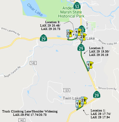 In December 2018, the CTC approved for future consideration of funding a project
located on Route 29 in Lake County that proposes to widen shoulders along
three segments of Route 29. The project also proposes to construct a
12-foot wide northbound truck climbing lane, extend and repair existing
drainage facilities, and install metal beam guardrail. This proposed
project addresses the need to reduce the frequency and severity of
collisions at these three segments of Route 29. The proposed project is
estimated to cost approximately $13.2 million. This project is currently
funded and programmed in the 2018 State Highway Operations and Protection
Program (SHOPP) for approximately $10.8 million. Construction is estimated
to begin in Fiscal Year (FY) 2019-20. The scope, as described for the
preferred alternative, is consistent with the project scope programmed by
the Commission in the 2018 SHOPP.
In December 2018, the CTC approved for future consideration of funding a project
located on Route 29 in Lake County that proposes to widen shoulders along
three segments of Route 29. The project also proposes to construct a
12-foot wide northbound truck climbing lane, extend and repair existing
drainage facilities, and install metal beam guardrail. This proposed
project addresses the need to reduce the frequency and severity of
collisions at these three segments of Route 29. The proposed project is
estimated to cost approximately $13.2 million. This project is currently
funded and programmed in the 2018 State Highway Operations and Protection
Program (SHOPP) for approximately $10.8 million. Construction is estimated
to begin in Fiscal Year (FY) 2019-20. The scope, as described for the
preferred alternative, is consistent with the project scope programmed by
the Commission in the 2018 SHOPP.
(Source: December 2018 CTC Minutes, Agenda Item
2.2c(1))
In June 2019, the CTC approved the following scope
amendment to the SHOPP: 01-Lak-29 17.7/20.7 PPNO 3203 Proj
0115000004. Route 29 Near Lower Lake, at various locations from 0.1
mile south of C Street to 0.2 mile north of Bell Park Avenue.
Widen for truck climbing lanes and shoulders. Note: Increased construction
capital is due to significant cost and quantity increases to roadway
excavation, asphalt, culverts, and mobilization. Temporary railing,
erosion control items, and structural concrete were originally not
accounted for. Reduce R/W capital due to reduction in environmental
mitigation and permitting fees. Update post miles to refine the project
limits. Correct the performance to correlate with original reporting
during project initiation. Updated total cost: $12,331K.
(Source: June 2019 CTC Minutes, Agenda Item
2.1a.(1) Scope Item 9)
In December 2019, the CTC had the following SHOPP
Safety allocation on its agenda: 01-Lak-29 17.7/20.7 PPNO 3203 Proj ID
0115000004 EA 0E730. On Route 29 Near Lower Lake, at various locations
from 0.1 mile south of C Street to 0.2 mile north of Bell Park Avenue.
Outcome/Output: Improve safety by widening for shoulders and truck
climbing lanes. This project will reduce the number and severity of
collisions $9,529,000
(Source: December 2019 CTC Agenda, Agenda Item
2.5f.(3) #1)
In June 2011, the CTC approved $6.1 million to repave stretches of Route 29 and Route 53 in Lake County. The Route 29 work will go from just south of the junction with Route 53 (approx 29 LAK 20.29) in Lower Lake to just north of it. For Route 53, the work will go from Route 29 to just north of 40th Avenue in Clearlake.
Kelseyville/Lower Lake Expressway (~ LAK 20.37 to LAK R35.466)
As of February 2000, the Route 20 corridor is a hot spot. Mendocino, Lake, and Colusa Counties have all agreed that they would like to see four lane road all along the corridor, which is considered a rural principal arterial. In Lake County, rather than upgrading Route 20 along the North shore of the lake, the principal arterials will be Route 29 and Route 53 along the South side of the lake. Project Study Reports in progress for the following:
The SAFETEA-LU act, enacted in August 2005 as the reauthorization of TEA-21, provided the following expenditures on or near this route: High Priority Project #3803: Expansion of Kelseyville/Lower Lake Expressway in Lake County. $5,000,000.
The upgrading of the route near Kelseyville was the subject of a draft EIR at the November 2007 CTC meeting. The basic issue is how to adjust the centerline of the widened route.
In 2007, the CTC considered a request for funding from the Corridor Mobility Improvement Account (CMIA), which was not recommended for funding. This request was to construct an expressway from Diener Dr. (LAK 23.676) to Route 175 near Lakeport (LAK 30.964).
On AAroads, it was noted that the freeway bypass of
Lakeport was more to provide a section of improved Route 29 between Lower
Lake and Route 20 to serve as a through commercial route to bypass the
section of Route 20 that follows the north shore of Clear Lake. That
segment of Route 20 would be difficult and impractical to expand because
of both physical limitations (it's on a narrow ledge wedged in between the
lake and the mountain along much of that stretch). Using Route 29 along
the south shore and the previously enhanced Route 53 to return to Route 20
provides an alternative that's not significantly longer than Route 20
itself -- and is much more conducive to capacity enlargement -- hence the
4-laning project under discussion. There may note be any feasible way to
effectively increase capacity on Route 29 from Calistoga to at least
Middletown because of the topology around Mt. St. Helens.
(Source: Sparker at AAroads, 7/4/2016)
In May 2016, it was reported that CalTrans is planning
to widen a section of Route 29 to four lanes. The proposal presented at a
public meeting in early June discussed a widening that would extend eight
miles, the Kit’s Corner intersection in Kelseyville all the way to
Diener Drive in Lower Lake. There is some concern the project would
infringe upon wetlands areas. It will also require new right-of-ways. It
was reported that an environmental impact report had been drafted and was
available for public review. If approved, the project is planned to begin
construction in summer 2018.
(Record Bee Community News, 5/31/2016)
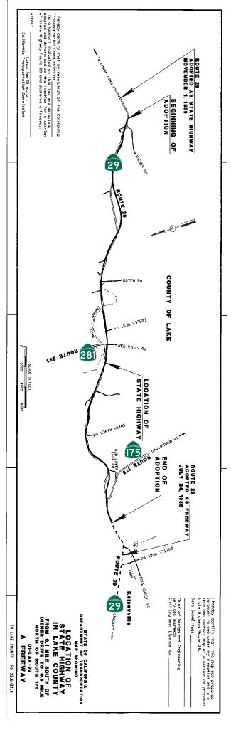 In January 2017, the CTC approved adoption of a portion
of Route 29 as a freeway to be able to construct an expressway project in
the State highway system. This project will reconfigure a portion of the
existing two-lane conventional highway to a four-lane divided expressway
with access control. The project will improve east-west connectivity,
relieve congestion, reduce delays and improve safety for interregional
traffic on Route 29. A final Environmental Impact Report/Environmental
Assessment and De Minimis Section 4(f) were prepared pursuant to the
California Environmental Quality Act and the National Environmental Policy
Act on November 23, 2016, and a project report was prepared by the
Department and approved on November 30, 2016. In August 2016, the CTC
approved $459K for right of way acquisition and $5,646K in construction
for various locations along Route 29 near Lower Lake to widen the route
for truck lanes and shoulders. Route 29 from the community of Lower Lake
to 3.5 miles north of Route 175, near Kelseyville, was adopted as a State
Highway by Resolution of the California Highway Commission (CHC) in July
1956 and November 1959. The segment north of this location was adopted as
a freeway by CHC on July 24, 1956. From Lower Lake to Kelseyville, Route 29 is primarily a mix of open space scenic corridor with some low to
moderate density residential land use. Property adjacent to the project is
primarily zoned as Rural Lands and Agriculture under the Lake County
General Plan and it traverses rolling to semi-mountainous terrain. Within
the project limits, Route 29 is a traversable two-lane conventional
highway with narrow shoulders, generally only two-feet wide. There are
many at-grade intersections and road approaches within the project limits.
The majority of the project length is currently barrier striped, which
restricts passing. Consequently, there are long queues of cars following
slowermoving vehicles or trucks, creating congestion and unstable traffic
flow. The lack of passing opportunities is expected to create greater
congestion and increase delays as traffic volumes increase. This project
proposes to convert an eight-mile segment of two-lane conventional highway
between the communities of Lower Lake and Kelseyville, to a four-lane
expressway with access control. The alignment generally follows the
existing highway corridor. The design improves the horizontal and vertical
alignment, adds lanes to create safer passing opportunities, widens the
shoulders, and provides a 46-foot wide median. Safety benefits include
increases to sight distances, enhancement of recovery areas, separation
from opposing traffic, and minimization of exposure to fixed objects.
Additionally, many existing at-grade road approaches to Route 29 will be
consolidated and portions of the realigned existing highway will be used
as frontage roads. These frontage roads will eventually be relinquished to
Lake County. The proposed four-lane expressway will significantly improve
overall safety to motorists and provide a modern four-lane facility that
meets current design standards. In 1988, the Department approved two
Project Study Reports (PSR) to upgrade this facility in two segments. Both
PSRs recommended proceeding with an expressway alternative. In 1999, a
supplemental PSR was prepared to study additional improvements and
alternatives. Stakeholder meetings were held with the Federal Highway
Administration, where it was agreed that the two Route 29 improvement
projects would be combined for environmental study purposes and include
the study of a freeway alternative. In 2001, after two years of studies on
various highway, expressway, and freeway alternatives on varying
alignments with differing median widths, the freeway alternatives were
eliminated from further study due to funding constraints, as construction
cost for a four-lane freeway was estimated to be nearly twice the cost of
the expressway alternatives. In 2002, the two projects were officially
combined in the 2002 STIP, the project description and post miles were
updated, and environmental studies for the combined segments were
initiated. In March 2003 the NEPA/404 process was initiated. Due to
funding constraints, the project will be constructed in two phases. It is
proposed to first construct the three-mile segment of four-lane expressway
beginning approximately 0.6 mile north of the Route 281/Route 29
intersection. As funding becomes available, the remaining portion of the
project will be programmed and constructed. The total cost for
construction of the first phase is estimated at $76.3 million. SHOPP
funding is from the Highway Safety Improvement Program, and STIP funding
is by the Regional Improvement Program, the Interregional Improvement
Program, and by Demonstration Funds from Transportation Equity Act-21 and
Safe, Accountable, Flexible, Efficient Transportation Equity Act: A Legacy
for Users. Shortly after the Commission’s approval of the Route 29
freeway route adoption, the Department will approve the denomination of
Route 29 freeway as a controlled access highway, within the project
limits. The Department will then execute a Controlled Access Highway
Agreement (CAHA) with the County of Lake following the Commission’s
approval of this route adoption. Portions of the existing Route 29
alignment serving as frontage roads for the new alignment will be
relinquished to the County of Lake after construction completion.
In January 2017, the CTC approved adoption of a portion
of Route 29 as a freeway to be able to construct an expressway project in
the State highway system. This project will reconfigure a portion of the
existing two-lane conventional highway to a four-lane divided expressway
with access control. The project will improve east-west connectivity,
relieve congestion, reduce delays and improve safety for interregional
traffic on Route 29. A final Environmental Impact Report/Environmental
Assessment and De Minimis Section 4(f) were prepared pursuant to the
California Environmental Quality Act and the National Environmental Policy
Act on November 23, 2016, and a project report was prepared by the
Department and approved on November 30, 2016. In August 2016, the CTC
approved $459K for right of way acquisition and $5,646K in construction
for various locations along Route 29 near Lower Lake to widen the route
for truck lanes and shoulders. Route 29 from the community of Lower Lake
to 3.5 miles north of Route 175, near Kelseyville, was adopted as a State
Highway by Resolution of the California Highway Commission (CHC) in July
1956 and November 1959. The segment north of this location was adopted as
a freeway by CHC on July 24, 1956. From Lower Lake to Kelseyville, Route 29 is primarily a mix of open space scenic corridor with some low to
moderate density residential land use. Property adjacent to the project is
primarily zoned as Rural Lands and Agriculture under the Lake County
General Plan and it traverses rolling to semi-mountainous terrain. Within
the project limits, Route 29 is a traversable two-lane conventional
highway with narrow shoulders, generally only two-feet wide. There are
many at-grade intersections and road approaches within the project limits.
The majority of the project length is currently barrier striped, which
restricts passing. Consequently, there are long queues of cars following
slowermoving vehicles or trucks, creating congestion and unstable traffic
flow. The lack of passing opportunities is expected to create greater
congestion and increase delays as traffic volumes increase. This project
proposes to convert an eight-mile segment of two-lane conventional highway
between the communities of Lower Lake and Kelseyville, to a four-lane
expressway with access control. The alignment generally follows the
existing highway corridor. The design improves the horizontal and vertical
alignment, adds lanes to create safer passing opportunities, widens the
shoulders, and provides a 46-foot wide median. Safety benefits include
increases to sight distances, enhancement of recovery areas, separation
from opposing traffic, and minimization of exposure to fixed objects.
Additionally, many existing at-grade road approaches to Route 29 will be
consolidated and portions of the realigned existing highway will be used
as frontage roads. These frontage roads will eventually be relinquished to
Lake County. The proposed four-lane expressway will significantly improve
overall safety to motorists and provide a modern four-lane facility that
meets current design standards. In 1988, the Department approved two
Project Study Reports (PSR) to upgrade this facility in two segments. Both
PSRs recommended proceeding with an expressway alternative. In 1999, a
supplemental PSR was prepared to study additional improvements and
alternatives. Stakeholder meetings were held with the Federal Highway
Administration, where it was agreed that the two Route 29 improvement
projects would be combined for environmental study purposes and include
the study of a freeway alternative. In 2001, after two years of studies on
various highway, expressway, and freeway alternatives on varying
alignments with differing median widths, the freeway alternatives were
eliminated from further study due to funding constraints, as construction
cost for a four-lane freeway was estimated to be nearly twice the cost of
the expressway alternatives. In 2002, the two projects were officially
combined in the 2002 STIP, the project description and post miles were
updated, and environmental studies for the combined segments were
initiated. In March 2003 the NEPA/404 process was initiated. Due to
funding constraints, the project will be constructed in two phases. It is
proposed to first construct the three-mile segment of four-lane expressway
beginning approximately 0.6 mile north of the Route 281/Route 29
intersection. As funding becomes available, the remaining portion of the
project will be programmed and constructed. The total cost for
construction of the first phase is estimated at $76.3 million. SHOPP
funding is from the Highway Safety Improvement Program, and STIP funding
is by the Regional Improvement Program, the Interregional Improvement
Program, and by Demonstration Funds from Transportation Equity Act-21 and
Safe, Accountable, Flexible, Efficient Transportation Equity Act: A Legacy
for Users. Shortly after the Commission’s approval of the Route 29
freeway route adoption, the Department will approve the denomination of
Route 29 freeway as a controlled access highway, within the project
limits. The Department will then execute a Controlled Access Highway
Agreement (CAHA) with the County of Lake following the Commission’s
approval of this route adoption. Portions of the existing Route 29
alignment serving as frontage roads for the new alignment will be
relinquished to the County of Lake after construction completion.
The approval for future consideration of funding noted: This project in Lake County will widen the existing two-lane highway to a four-lane divided highway with access control. The project will begin near Diener Drive and end just west of the Route 29/Route 175 Intersection. The project is programmed in the 2016 State Highway Operation Program for $46,200,000 in capital and support. In addition, the project is programmed in the 2016 State Transportation Improvement Program for $70,527,000 for capital and support. Construction is estimated to begin in Fiscal Year 2018-19. The scope, as described for the preferred alternative, is consistent with the project scope programmed by the Commission in the 2016 State Highway Operation and Protection Program and the 2016 State Transportation Improvement Program.
The 2018 STIP, approved at the CTC March 2018 meeting, appears to increase the funding for PPNO 3100 (Widen to 4 lanes, Rt 281-Rt 175, Seg 2C) [LAK 28.5/31.6] from $14,767K to $15,087K, which appears to be construction in FY18-19. This segment is described as "In Lake County near Kelseyville from 0.6 mile north of the Junction of Route 29/Route 281 to 0.6 mile north of the Junction of Route 29/Route 175. Construct Segment 2-C, an approximately 3.1 mile portion of the 8-mile long, 4-lane Expressway Project. It also provided $900K for PS&E for PPNO 3122, Segment 2A, and $118K for PS&E for PPNO 3121, Segment 2B. Segment 2B also gets $792K in Advance Project Development Element (APDE) funds. The project report notes: The project would likely be constructed in phases (segments) as full funding sources have not been identified. The recommended sequence of construction will be to construct the 8.0 miles in three segments, proceeding from west to east. It is proposed to first construct the segment from approximately PM 28.5 to 31.6, then the segment from PM 26.1 to 29.1, and lastly the segment from PM 23.6 to 26.9. These segments are referred to herein as Segments 2C, 2B and 2A, respectively.
In June 2019, the CTC approved the following
construction allocation: $52,157,000. 01-Lake-29 28.5/31.6 ProjID
0114000043. Route 29 Near Kelseyville, from 0.6 mile north of Route 29/Route 281 Junction to north of Route 29/Route 175 Junction. Improve
safety by realigning curves and upgrading shoulders throughout project
limits. This project will reduce the number and severity of collisions.
Const. $44,128,000 Const Engr. $8,029,000
(Source: June 2019 CTC Minutes, Agenda Item
2.5b.(1) Item 2)
Additionally, in June 2019, the CTC approved an
allocation of $28,240,000 for two STIP projects: $27,858,000 for Lake-29
Expressway Project (01-LAK-29 28.5/31.6) - Segment 2C (PPNO 01-3100,
ProjID 0114000044). The project is on Route 29 in Lake County near
Kelseyville from 0.6 mile north of the Junction of Route 29/Route 281 to
0.6 mile north of the Junction of Route 29/Route 175. Construct Segment
2-C, an approximately 3.1 mile portion of the 8-mile long, 4-lane
Expressway project. The ~27.8M is from two accounts: RIP (CON ENG
$999,000, CONST $11,313,000) and IIP (CON ENG $1,250,000, CONST
$14,296,000). There was also an allocation of $382,000 for the associated
mitigation child project (PPNO 01-3100M), divided into RIP (CON ENG
$55,000, CONST $132,000) and IIP (CON ENG $55,000, CONST $140,000).
(Source: June 2019 CTC Minutes, Agenda Item
2.5c.(1))
In March 2020, the CTC approved the 2020 STIP, which
appeared to continue programmed funding for PPNO 3100 "Widen to 4 lanes,
Rt 281-Rt 175, Seg 2C (RIP)(SHOPP)" and PPNO 3100M "Widen to 4 lanes, Sgmt
2C-Mitigation (RIP)(split 6-19)". It also continued programmed funding for
PPNO 3121 "Expressway-Segment 2B (RIP)(APDE)" and PPNO 3122
"Expressway-Segment 2A (RIP)". The STIP also included PPNO 3100 Widen to 4
lanes, Segment 2C (IIP)($3,075 incr at vote, in the Interregional portion
of the STIP with no change in programming: $17,755K in prior year funding,
as well as PPNO 3100M Widen to 4 lanes, Sgmt 2C-Mitigation (IIP) (split
6-19) with $196K in prior year funding. It also included PPNO 3122
Expressway - Segment 2A (IIP)(APDE) and PPNO 3121 Expressway - Segment 2B
(IIP) (APDE) in the Interregional portion of the STIP with no change in
programming: each with $5,100K in prior year funding.
(Source: March 2020 CTC Agenda, Item 4.7, 2020 STIP
Adopted 3/25/2020)
 In August 2020, it was reported that a groundbreaking occured in July for the Lake 29
Expressway, a $59 million project aimed at addressing the area's
most significant safety concerns – reducing collision rates for
motorists and accommodating truck transportation along the interregional
east-west highway. This project, located between Kelseyville and Lower
Lake, is the first funded segment of a three-part series. It will include
safety improvements and safe mobility for multiple modes; improve large
commercial truck transportation, goods movement and services; reduce
traffic on Route 20 and promote opportunities for complete streets and
traffic calming on the Northshore; improve wildfire access and emergency
response access; and provide a capacity area for population growth. On the
drawing board since the late 1980s, Caltrans staff said the overall Lake
29 Expressway project covers about 8 miles. This first segment, called
“2C,” is about 3 miles long. It will extend from Diener Drive
near Lower Lake to just north of Route 175/Cobb, about half a mile west of
Red Hills Road near Kelseyville. The other two portions, segment
“2A” and “2B,” each less than 3 miles long, are to
the east of 2C and are now being designed. Caltrans staff said there
isn’t yet funding for those future project sections, although
they’ve cleared the environmental requirements and have the funds
for design work. The 2C stretch of the project was determined to be a
priority as it will meet the traffic flow needs in the areas of the county
that are growing the fastest, Caltrans staff said. One of the project
benefits will be greater sight distance. Other benefits will include
bigger highway shoulders, two lanes in each direction with plenty of width
for passing, curves that are up to current highway standards, three or
four acceleration and deceleration lanes, a smoother and easier drive and
a full-width median. It also will create opportunities for vehicles to
more safely pass.
In August 2020, it was reported that a groundbreaking occured in July for the Lake 29
Expressway, a $59 million project aimed at addressing the area's
most significant safety concerns – reducing collision rates for
motorists and accommodating truck transportation along the interregional
east-west highway. This project, located between Kelseyville and Lower
Lake, is the first funded segment of a three-part series. It will include
safety improvements and safe mobility for multiple modes; improve large
commercial truck transportation, goods movement and services; reduce
traffic on Route 20 and promote opportunities for complete streets and
traffic calming on the Northshore; improve wildfire access and emergency
response access; and provide a capacity area for population growth. On the
drawing board since the late 1980s, Caltrans staff said the overall Lake
29 Expressway project covers about 8 miles. This first segment, called
“2C,” is about 3 miles long. It will extend from Diener Drive
near Lower Lake to just north of Route 175/Cobb, about half a mile west of
Red Hills Road near Kelseyville. The other two portions, segment
“2A” and “2B,” each less than 3 miles long, are to
the east of 2C and are now being designed. Caltrans staff said there
isn’t yet funding for those future project sections, although
they’ve cleared the environmental requirements and have the funds
for design work. The 2C stretch of the project was determined to be a
priority as it will meet the traffic flow needs in the areas of the county
that are growing the fastest, Caltrans staff said. One of the project
benefits will be greater sight distance. Other benefits will include
bigger highway shoulders, two lanes in each direction with plenty of width
for passing, curves that are up to current highway standards, three or
four acceleration and deceleration lanes, a smoother and easier drive and
a full-width median. It also will create opportunities for vehicles to
more safely pass.
(Source/Image Source: Lake County News, 8/6/2020)
In June 2023, it was reported that a ribbon cutting
ceremony was held for the completion of the $85 million first segment of
the Konocti Corridor Project in Lake County. This project is a cooperative
effort funded by Caltrans, the Lake County Area Planning Council (LAPC),
and the Federal Highway Administration (FHWA). Located between the
communities of Lower Lake and Kelseyville, the new three-mile segment of
Route 29 was widened to a four-lane expressway to improve safety. This was
the first phase of a safety project that will eventually widen an 8-mile
section of Route 29. The recently completed 3-mile segment, 2C, extends
from east of Route 175 near Kelseyville to Konocti Rock Company Road.
The other two portions, segment 2A and 2B, are to the east of 2C, and the
partners are working to secure funding to complete the project. The new
expressway is part of a long-range plan to divert traffic from communities
on the northern end of Clearlake, where pedestrian and nonmotorized
traffic safety have been an ongoing concern.
(Source: Redheaded Blackbelt, 6/4/2023; Lake County News, 6/10/2023)
Lakeport (Route 175) to Upper Lake (Route 20)
Manning Creek Bridge No. 14-0067 (LAK R38.91) / Robinson Creek Bridge No. 14 -0030 (LAK PM 50.82)
In June 2019, the CTC approved the following SHOPP
scope amendment: 01-Lak-20 Var 9.4 PPNO 3098
ProjID 0113000122. Route 20 Near Upper Lake, at Polk Jones Cattlepass
Bridge No. 14-0034 (PM 9.41) and Morrison Creek Bridge No. 14-0004
(PM 16.81); also, on Route 29 at Manning Creek Bridge No. 14-0067
(PM R38.91). Replace and upgrade bridge rails and widen one bridge.
The need to widen Morrison Creek Bridge to provide raised pedestrian
sidewalks on both sides requires cultural analysis, resulting in a
schedule delay. Transfer the scope and associated cost and performance of
this bridge to project EA 0E081/PPNO 01-3130, which has a schedule that
aligns with this delay. Adjusted total cost: $3,775K
(Source: June 2019 CTC Minutes, Agenda Item
2.1a.(1) Scope Item 7)
In June 2019, the CTC also approved the following SHOPP
scope amendment: 01-Lak-29 50.8 PPNO 3130 ProjID 0118000172. Route 29 Near
Upper Lake, at Robinson Creek Bridge No. 14 -0030 (PM 50.82); also on
Route 175 at Kelsey Creek Bridge No. 14-0044 (PM 19.48); also on
Route 20 at Morrison Creek Bridge No. 14-0004 (PM 16.81). Widen
bridge and upgrade bridge rails at Robinson Creek Bridge and
Morrison Creek Bridge, and replace existing Kelsey Creek Bridge.
Remove Morrison Creek Bridge from project EA 0E080/PPNO 01-3098 and add to
this project. The need for cultural analysis delayed the Morrison Creek
Bridge delivery schedule and it now better aligns with this project.
Further cost increases are associated with additional piles, retaining
wall, and required environmental mitigation. Updated total cost: $10,833K.
(Source: June 2019 CTC Minutes, Agenda Item
2.1a.(1) Scope Item 11)
The 2020 SHOPP, approved in May 2020, included the
following Bridge Preservation item of interest (carried over from the 2018
SHOPP): 01-Lake-29 PM 50.8 PPNO 3130 Proj ID 0118000172 EA 0E081. Route 29
near Upper Lake, at Robinson Creek Bridge No. 14-0030 (PM 50.82); also on
Route 175 at Kelsey Creek Bridge No. 14-0044 (PM 19.48); also on Route 20
at Morrison Creek Bridge No. 14-0004 (PM 16.81). Widen bridge and upgrade
bridge rails at Robinson Creek Bridge and Morrison Creek Bridge, and
replace existing Kelsey Creek Bridge. Programmed in FY20-21, with
construction scheduled to start in Sept. 2021. Total project cost is
$14,076K, with $9,441K being capital (const and right of way) and $4,635K
being support (engineering, environmental, etc.),
(Source: 2020 Approved SHOPP a/o May 2020)
In August 2020, the CTC approved for future
consideration of funding a project is located on Route 20 (01-Lak-20, PM
16.81), Route 29 (01-Lak-29, PM 50.82), and Route 175 (01-Lak-175, PM
19.48) at various locations in Lake County. The Department proposes to
widen and upgrade bridge rails at Robinson Creek Bridge and Morrison
Creek Bridge, and replace existing Kelsey Creek Bridge. This project is
fully funded and is currently programmed in the 2020 State Highway
Operation Protection Program (SHOPP) for a total of $14,076,000 which
includes Construction (capital and support) and Right of Way (capital and
support). Construction is estimated to begin in Fiscal Year 2021-2022. The
scope, as described for the preferred alternative, is consistent with the
project scope programmed by the Commission in the 2020 SHOPP.
(Source: August 2020 CTC Agenda, Agenda Item
2.2c.(1))
Related to the previous item, also in August 2020 the
CTC approved the following financial allocation: $2,220,000 for PS&E;
$223,000 for R/W Support. 01-Lak-29 PM 50.8. PPNO 3130 ProjID 0118000172
EA 0E081. Route 29 Near Upper Lake, at Robinson Creek Bridge No. 14-0030
(PM 50.82); also on Route 175 at Kelsey Creek Bridge No. 14-0044 (PM
19.48); also on Route 20 at Morrison Creek Bridge No. 14-0004 (PM 16.81).
Widen bridge and upgrade bridge rails at Robinson Creek Bridge and
Morrison Creek Bridge, and replace existing Kelsey Creek Bridge.
(Source: August 2020 CTC Agenda, Agenda Item
2.5b.(2b) #1)
In August 2021, the CTC approved the following
construction phase allocations: $12,217,000. 01-Lak-29 50.82. PPNO
01-3130; ProjID 0118000172; EA 0E081. Route 29 Near Upper Lake, at
Robinson Creek Bridge № 14-0030; also on Route 175 at Kelsey Creek
Bridge № 14-0044 (PM 19.48); also on Route 20 at Morrison Creek
Bridge № 14-0004 (PM 16.81). Outcome/Output: Widen bridge and
upgrade bridge rails at Robinson Creek Bridge and Morrison Creek Bridge,
and replace existing Kelsey Creek Bridge. Allocation: CON ENG $2,330,000
CONST $8,608,000. (Future consideration of funding approved under
Resolution E-20-67; August 2020.)
(Source: August 2021 CTC Agenda, Agenda Item
2.5b.(1) #5)
 Business Routes
 Naming
 There was a movement to name parts of Rout 29 after Robert Mondavi. TheNapa
News reported in December 2004 that the plan was to put the
legendary 91-year-old vintner's name on Route 29 through Napa County (~
NAP 0.000 to NAP 48.557). Sen. Wes Chesbro is sounding out local cities
and wine industry groups to find out if they would support dedicating this
wine highway to the Napa Valley's most famous winemaker. The Napa County
Board of Supervisors has unanimously supported the idea, has have elected
city leaders serving on the Napa County Transportation Planning Agency, as
long as the wine industry goes along. However, it appears that no
resolution was ever introduced to do the official naming.
There was a movement to name parts of Rout 29 after Robert Mondavi. TheNapa
News reported in December 2004 that the plan was to put the
legendary 91-year-old vintner's name on Route 29 through Napa County (~
NAP 0.000 to NAP 48.557). Sen. Wes Chesbro is sounding out local cities
and wine industry groups to find out if they would support dedicating this
wine highway to the Napa Valley's most famous winemaker. The Napa County
Board of Supervisors has unanimously supported the idea, has have elected
city leaders serving on the Napa County Transportation Planning Agency, as
long as the wine industry goes along. However, it appears that no
resolution was ever introduced to do the official naming.
(Image source: NAIF Blog)
 The portion of this route in Lake County that is between the Napa county line and Route 175 (~ NAP 0.0 to LAK
5.749) is named the "Earle W. Wrieden Memorial Highway". Earle W.
Wrieden was born in Middletown, California on February 8, 1910, and,
except for one year in Berkeley, lived most of his life in Middletown. He
was appointed to the Lake County Board of Supervisors in 1949, where he
served for 24 years and where he was instrumental in many changes,
advances, and improvements for the people of Middletown, Lake County, and
northern California. He was heavily involved in water issues in Lake
County, especially relating to Cache Creek and Putah Creek. However, his
prime interest was in roads, including securing funds for the construction
and maintenance of county roads and facilitating the adoption of highly
traveled county roads into the state highway system. Wrieden spearheaded
the creation of passing lanes on Route 29 over Mount St. Helena. Named by
Senate Concurrent Resolution 18; Resolution Chapter 80, 7/1/2001.
The portion of this route in Lake County that is between the Napa county line and Route 175 (~ NAP 0.0 to LAK
5.749) is named the "Earle W. Wrieden Memorial Highway". Earle W.
Wrieden was born in Middletown, California on February 8, 1910, and,
except for one year in Berkeley, lived most of his life in Middletown. He
was appointed to the Lake County Board of Supervisors in 1949, where he
served for 24 years and where he was instrumental in many changes,
advances, and improvements for the people of Middletown, Lake County, and
northern California. He was heavily involved in water issues in Lake
County, especially relating to Cache Creek and Putah Creek. However, his
prime interest was in roads, including securing funds for the construction
and maintenance of county roads and facilitating the adoption of highly
traveled county roads into the state highway system. Wrieden spearheaded
the creation of passing lanes on Route 29 over Mount St. Helena. Named by
Senate Concurrent Resolution 18; Resolution Chapter 80, 7/1/2001.
(Image source: Middletown History)
The interchange of Route 29 and Trancas Road in Napa County (~NAP 13.051) is named the John Castro Memorial Interchange. It was named in memory of John Castro, a life-long resident of the City of Martinez. John Castro contributed to the City of Martinez in many ways, including raising cattle and goats, farming corn and hay, and by helping the less fortunate people. He served two duties in Vietnam, returning home to work serving the public by constructing bridges. In particular, he helped many individual's commute time by working on Route 4 improvements between the City of Martinez and the City of Hercules. He also worked on the Route 29/Trancas Road Project in Napa County in order to tunnel the highway under the wine train in order to avoid traffic delays. It was while completing the overcrossing and railroad transferring on July 3, 2003, that a fatal accident took the life of John Castro at the age of 54. Named by Senate Concurrent Resolution 68, July 16, 2004, Chapter 119.
The portion of this route in the City of Yountville in the County of Napa from Darms Lane to Yount Mill Road (NAP 16.5 to NAP 21.614) is named the "Veterans’ Memorial Highway". It was named to honor the men and women who have served in the Armed Forces of the United States of America, who have defended our country, and who have suffered disabilities and injuries in protecting the freedom, rights, and privileges enjoyed by all Americans. Nearly two million veterans reside in the State of California, and the County of Napa is home to many of these brave and honorable individuals. Napa Valley residents were some of the first United States military veterans from California, and in 1884 the Veterans’ Home of California, Yountville (Veterans’ Home), in the County of Napa, became the first facility for veterans in the United States;. The Veterans’ Home is home to 1,200 veterans, including men and women who have served in World War II, the Korean and Vietnam wars, the Gulf War, and the wars in Iraq and Afghanistan. The Veterans’ Home has grown to be the largest veterans’ home in the United States and is an integral part of the Napa Valley community. The Veterans’ Home provides for the future health care of its resident veterans, including facilities that provide residential care for the elderly, skilled nursing care, and a memory care center for veterans with various forms of dementia. Over its 133 years of operation, the Veterans’ Home has become a focal point for the Napa Valley community with its 1,200 seat Lincoln Theater, a 9-hole golf course, the Borman Field baseball stadium, bowling lanes, a swimming pool, and a military base exchange branch store. All of these facilities are available for use by resident veterans at no additional cost and include a fitness center, a resident-operated television station, an auto hobby shop, a 35,000 volume library, a creative arts center, and a multifaith chapel. Named by ACR 67, Res. Chapter 159, 8/21/2018.
 The portion of Route 29 from NAP 37.9 to NAP 39.5 in Napa County
is named the "Robert Louis Stevenson's Historic Trail to Silverado. "
This segment was named to commemorate the history of "Silverado". In the
1850s, volunteers built the Old Bull Trail from what is today the City of
Calistoga over Mount St. Helena in Napa County to what is today Middletown
in Lake County. Due to grades exceeding 35% along the Old Bull Trail,
which prevented wagon travel, the Legislature, in 1866, authorized John
Lawley to construct a private toll road to replace most of the Old Bull
Trail starting approximately 1.5 miles north of the City of Calistoga. The
toll road over Mount St. Helena was completed in 1868 with grades of just
12%. This toll road is still in use today as a public road and is known
both as the "Old Toll Road" and as "Lawley Road". In 1872, John Lawley,
along with William Montgomery and William Patterson, founded the Monitor
Ledge Mine on Mount St. Helena just off the Old Toll Road and later
renamed that mine and the surrounding community "Silverado". During one
point in its short three-year life, the mining town of Silverado housed
over 1,000 people. Many more people came and went during that time in
search of fortunes, every one of whom traveled the toll road and the 1.5
mile remnant of the Old Bull Trail that connected that toll road to
Calistoga and to the rest of the Napa Valley. In the summer of 1880, a
young author, running low on cash, and his new bride left their honeymoon
suite in the resort town of Calistoga to become squatters in the mining
town of Silverado, which had been abandoned five years earlier. One
hundred twenty-five years ago, Robert Louis Stevenson's The Silverado
Squatters, a travelogue detailing the young author's trip to Napa Valley,
was published for the first time. In The Silverado Squatters, the
best-selling author of Treasure Island and Strange Case of Dr. Jekyll and
Mr. Hyde introduced the world to the beauty of the Napa Valley and the
quality of its wine, famously describing it as "bottled poetry". In a
chapter of The Silverado Squatters entitled "Starry Drive," Robert Louis
Stevenson recounted the brilliant night sky above the 1.5 mile remnant of
the Old Bull Trail as he rambled back to his honeymoon perch one summer
evening. Few roads have ever been described so vividly. In 1921, a local
farm bureau successfully petitioned the County of Napa to name a series of
rough roads and trails running along the eastern spine of the Napa Valley,
known collectively as the "Old Back Road," the Silverado Trail after the
mining town Robert Louis Stevenson made famous. Although that collection
of roads running along Napa Valley's eastern spine ended at Tubbs Lane
just north of the Old Toll Road, the County of Napa ended the newly named
Silverado Trail 1.5 miles short of the Old Toll Road because the county
was making arrangements to turn that 1.5 mile stretch of road over to the
state to incorporate it into a new modern highway to be built by Lake
County. As a result of Napa County's decision to incorporate this stretch
of historic road into a modern highway, the history of this pioneer
pathway, Robert Louis Stevenson's "Starry Drive" and the last leg of the
trail to Silverado, has been lost until now. That stretch of road predates
John Lawley's Old Toll Road, was originally built by California pioneers
in the 1850s, shortly after California's statehood, as part of the Old
Bull Trail, and is now memorialized by a historical marker in Middletown,
Lake County. That stretch of road also predates the City of Calistoga,
which was formed in 1867, and Lake County, which was carved out of Napa
County in 1861. Named by Senate Concurrent Resolution (SCR) 37, Resolution
Chapter 93, on 8/20/2010.
The portion of Route 29 from NAP 37.9 to NAP 39.5 in Napa County
is named the "Robert Louis Stevenson's Historic Trail to Silverado. "
This segment was named to commemorate the history of "Silverado". In the
1850s, volunteers built the Old Bull Trail from what is today the City of
Calistoga over Mount St. Helena in Napa County to what is today Middletown
in Lake County. Due to grades exceeding 35% along the Old Bull Trail,
which prevented wagon travel, the Legislature, in 1866, authorized John
Lawley to construct a private toll road to replace most of the Old Bull
Trail starting approximately 1.5 miles north of the City of Calistoga. The
toll road over Mount St. Helena was completed in 1868 with grades of just
12%. This toll road is still in use today as a public road and is known
both as the "Old Toll Road" and as "Lawley Road". In 1872, John Lawley,
along with William Montgomery and William Patterson, founded the Monitor
Ledge Mine on Mount St. Helena just off the Old Toll Road and later
renamed that mine and the surrounding community "Silverado". During one
point in its short three-year life, the mining town of Silverado housed
over 1,000 people. Many more people came and went during that time in
search of fortunes, every one of whom traveled the toll road and the 1.5
mile remnant of the Old Bull Trail that connected that toll road to
Calistoga and to the rest of the Napa Valley. In the summer of 1880, a
young author, running low on cash, and his new bride left their honeymoon
suite in the resort town of Calistoga to become squatters in the mining
town of Silverado, which had been abandoned five years earlier. One
hundred twenty-five years ago, Robert Louis Stevenson's The Silverado
Squatters, a travelogue detailing the young author's trip to Napa Valley,
was published for the first time. In The Silverado Squatters, the
best-selling author of Treasure Island and Strange Case of Dr. Jekyll and
Mr. Hyde introduced the world to the beauty of the Napa Valley and the
quality of its wine, famously describing it as "bottled poetry". In a
chapter of The Silverado Squatters entitled "Starry Drive," Robert Louis
Stevenson recounted the brilliant night sky above the 1.5 mile remnant of
the Old Bull Trail as he rambled back to his honeymoon perch one summer
evening. Few roads have ever been described so vividly. In 1921, a local
farm bureau successfully petitioned the County of Napa to name a series of
rough roads and trails running along the eastern spine of the Napa Valley,
known collectively as the "Old Back Road," the Silverado Trail after the
mining town Robert Louis Stevenson made famous. Although that collection
of roads running along Napa Valley's eastern spine ended at Tubbs Lane
just north of the Old Toll Road, the County of Napa ended the newly named
Silverado Trail 1.5 miles short of the Old Toll Road because the county
was making arrangements to turn that 1.5 mile stretch of road over to the
state to incorporate it into a new modern highway to be built by Lake
County. As a result of Napa County's decision to incorporate this stretch
of historic road into a modern highway, the history of this pioneer
pathway, Robert Louis Stevenson's "Starry Drive" and the last leg of the
trail to Silverado, has been lost until now. That stretch of road predates
John Lawley's Old Toll Road, was originally built by California pioneers
in the 1850s, shortly after California's statehood, as part of the Old
Bull Trail, and is now memorialized by a historical marker in Middletown,
Lake County. That stretch of road also predates the City of Calistoga,
which was formed in 1867, and Lake County, which was carved out of Napa
County in 1861. Named by Senate Concurrent Resolution (SCR) 37, Resolution
Chapter 93, on 8/20/2010.
(Image source: Wikipedia)
Portions of this are "Lower Lake" Road. (~ LAK 20.349 to LAK 31.034)
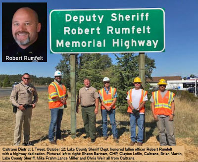 The portion of Route 29 from the intersection of Rout 175 in the City of Lakeport (LAK R40.144) to the 11th Street Undercrossing
(LAK R42.677) in the County of Lake is named the "Deputy Sheriff
Robert Rumfelt Memorial Highway". It was named in memory of Deputy
Sheriff Robert Rumfelt, who was born in Napa on December 1966, as the
first of three children born to Robert and Juanita Rumfelt. Robert Rumfelt
was raised in the County of Lake, where he attended Minnie Cannon
Elementary School in Middletown, Burns Valley Elementary School in
Clearlake, Oak Hill Elementary School in Lower Lake, and Terrace Middle
School in Lakeport, and graduated from Clear Lake High School in Lakeport
in 1985. Robert Rumfelt, immediately upon graduation, answered the call to
serve his country by enlisting in the United States Marine Corps where he
learned honor, courage, and commitment, traits which he carried throughout
his life. Robert Rumfelt served with distinction as a United States Marine
Corps infantryman assigned to the 2nd Battalion, 4th Marine Division in
Camp Lejeune, North Carolina, until he was honorably discharged as a
sergeant in 1992. Robert Rumfelt, while enlisted as a United States
Marine, was awarded the Sea Service Deployment Ribbon, the Overseas
Service Ribbon, the Good Conduct Medal, the Navy Unit Commendation Medal,
the National Defense Ribbon, the Southwest Asia Service Medal, the Kuwait
Liberation Medal, and the Rifle Sharpshooter Badge. Robert Rumfelt was
employed as a seasonal “hotshot/wilderness ranger” with the
United States Forest Service in Upper Lake from 1993 to 1994. Robert
Rumfelt put himself through the Napa Valley Junior College Police Academy,
graduated from the Academy in 1994, and continued his education, earning a
Bachelor of Arts Degree in Criminal Justice Management from Union
Institute and University in 2004. Robert Rumfelt worked as a police
officer for the City of Lakeport in the County of Lake from 1995 to 2009,
inclusive, as a patrol officer and K-9 handler. Robert Rumfelt was awarded
basic, intermediate, and advanced certificates from the California
Commission on Peace Officer Standards and Training. From 2006 to 2009,
inclusive, Robert Rumfelt took a leave of absence from the Lakeport Police
Department to serve as a police advisor to Iraqi law enforcement agencies
in Ramadi, Baghdad, Kurdistan, and Mosul. Robert Rumfelt was recognized by
United States Army Lieutenant Colonel Kirk C. Dorr as “the most
accomplished Law Enforcement Professional in [his] forward-deployed Army
Division” after the rescue of a soldier on March 3, 2010, following
an improvised explosive device attack on their convoy in which three
soldiers were injured. While still in contact with the enemy, Robert, at
great personal risk, ran from the last vehicle in the patrol to the front
of the convoy, and personally extracted a grievously injured soldier. Due
to Robert’s heroic efforts, the soldier was medically evacuated in
just enough time for doctors to save his life. Robert Rumfelt was known
for having a tough exterior, steel-eyed, penetrating gaze, and a caring,
compassionate heart, who would help any friend or stranger in need. Robert
Rumfelt was hired as a deputy sheriff for the County of Lake
Sheriff’s Office in 2014, and served as a patrol deputy, firearms
instructor, field training officer, and gang task force member. Robert
Rumfelt dedicated countless hours to mentoring at-risk youth, and coaching
the Clear Lake High School football team where he had a lasting impact on
the character, development, and maturity of dozens of athletes and
countless youth. Robert Rumfelt was known for his direct style of
communication in which nobody left a conversation with him wondering what
was on Rob’s mind. Robert Rumfelt loved the United States Marine
Corps, his law enforcement family, his friends, the Oakland Raiders,
hunting with his dogs, scuba diving, skydiving, good rum, and above all,
his family. Robert Rumfelt died in the line of duty on August 22, 2017.
Named by Senate Concurrent Resolution (SCR) 92, Res. Chapter 116,
7/6/2018.
The portion of Route 29 from the intersection of Rout 175 in the City of Lakeport (LAK R40.144) to the 11th Street Undercrossing
(LAK R42.677) in the County of Lake is named the "Deputy Sheriff
Robert Rumfelt Memorial Highway". It was named in memory of Deputy
Sheriff Robert Rumfelt, who was born in Napa on December 1966, as the
first of three children born to Robert and Juanita Rumfelt. Robert Rumfelt
was raised in the County of Lake, where he attended Minnie Cannon
Elementary School in Middletown, Burns Valley Elementary School in
Clearlake, Oak Hill Elementary School in Lower Lake, and Terrace Middle
School in Lakeport, and graduated from Clear Lake High School in Lakeport
in 1985. Robert Rumfelt, immediately upon graduation, answered the call to
serve his country by enlisting in the United States Marine Corps where he
learned honor, courage, and commitment, traits which he carried throughout
his life. Robert Rumfelt served with distinction as a United States Marine
Corps infantryman assigned to the 2nd Battalion, 4th Marine Division in
Camp Lejeune, North Carolina, until he was honorably discharged as a
sergeant in 1992. Robert Rumfelt, while enlisted as a United States
Marine, was awarded the Sea Service Deployment Ribbon, the Overseas
Service Ribbon, the Good Conduct Medal, the Navy Unit Commendation Medal,
the National Defense Ribbon, the Southwest Asia Service Medal, the Kuwait
Liberation Medal, and the Rifle Sharpshooter Badge. Robert Rumfelt was
employed as a seasonal “hotshot/wilderness ranger” with the
United States Forest Service in Upper Lake from 1993 to 1994. Robert
Rumfelt put himself through the Napa Valley Junior College Police Academy,
graduated from the Academy in 1994, and continued his education, earning a
Bachelor of Arts Degree in Criminal Justice Management from Union
Institute and University in 2004. Robert Rumfelt worked as a police
officer for the City of Lakeport in the County of Lake from 1995 to 2009,
inclusive, as a patrol officer and K-9 handler. Robert Rumfelt was awarded
basic, intermediate, and advanced certificates from the California
Commission on Peace Officer Standards and Training. From 2006 to 2009,
inclusive, Robert Rumfelt took a leave of absence from the Lakeport Police
Department to serve as a police advisor to Iraqi law enforcement agencies
in Ramadi, Baghdad, Kurdistan, and Mosul. Robert Rumfelt was recognized by
United States Army Lieutenant Colonel Kirk C. Dorr as “the most
accomplished Law Enforcement Professional in [his] forward-deployed Army
Division” after the rescue of a soldier on March 3, 2010, following
an improvised explosive device attack on their convoy in which three
soldiers were injured. While still in contact with the enemy, Robert, at
great personal risk, ran from the last vehicle in the patrol to the front
of the convoy, and personally extracted a grievously injured soldier. Due
to Robert’s heroic efforts, the soldier was medically evacuated in
just enough time for doctors to save his life. Robert Rumfelt was known
for having a tough exterior, steel-eyed, penetrating gaze, and a caring,
compassionate heart, who would help any friend or stranger in need. Robert
Rumfelt was hired as a deputy sheriff for the County of Lake
Sheriff’s Office in 2014, and served as a patrol deputy, firearms
instructor, field training officer, and gang task force member. Robert
Rumfelt dedicated countless hours to mentoring at-risk youth, and coaching
the Clear Lake High School football team where he had a lasting impact on
the character, development, and maturity of dozens of athletes and
countless youth. Robert Rumfelt was known for his direct style of
communication in which nobody left a conversation with him wondering what
was on Rob’s mind. Robert Rumfelt loved the United States Marine
Corps, his law enforcement family, his friends, the Oakland Raiders,
hunting with his dogs, scuba diving, skydiving, good rum, and above all,
his family. Robert Rumfelt died in the line of duty on August 22, 2017.
Named by Senate Concurrent Resolution (SCR) 92, Res. Chapter 116,
7/6/2018.
(Image source: Caltrans District 1 Facebook; Lake County Record Bee)
 Named Structures
 Bridge 21-0049, at the Napa River in Napa county (NAP R006.99), is named the "George F. Butler Memorial Bridge".
It was built in 1977, and was named by Assembly Concurrent Resolution 23,
Chapter 48, in 1991. George F. Butler was a CHP officer who was killed in
the line of duty at the age of 52. He was flying as an observer in a CHP
helicopter that was taking aerial photographs of a double traffic fatality
on Interstate 80 near Dixon. After finishing the photographs, the
helicopter then set down a short distance from the accident scene in an
open field adjacent to an irrigation canal. Butler exited the left side of
the aircraft and proceeded to walk up the edge of the canal’s raised
berm when he was struck by the helicopter's main rotor and hurled into the
empty irrigation canal. The 21-year veteran of the CHP was killed
instantly.
Bridge 21-0049, at the Napa River in Napa county (NAP R006.99), is named the "George F. Butler Memorial Bridge".
It was built in 1977, and was named by Assembly Concurrent Resolution 23,
Chapter 48, in 1991. George F. Butler was a CHP officer who was killed in
the line of duty at the age of 52. He was flying as an observer in a CHP
helicopter that was taking aerial photographs of a double traffic fatality
on Interstate 80 near Dixon. After finishing the photographs, the
helicopter then set down a short distance from the accident scene in an
open field adjacent to an irrigation canal. Butler exited the left side of
the aircraft and proceeded to walk up the edge of the canal’s raised
berm when he was struck by the helicopter's main rotor and hurled into the
empty irrigation canal. The 21-year veteran of the CHP was killed
instantly.
(Image source: California Assn of Highway Patrolmen)
Bridge No. 21-0047 on Route 29 at the City of Yountville (NAP 019.04) is officially designated the "Veterans' Home Memorial Bridge". It was built in 1959, and was named by Senate Concurrent Resolution No. 30, Chapter 127, in 1994. It was named after the Veterans Home of California in Yountville CA, which is a community of and for veterans located in the heart of scenic Napa Valley. The home provides residential accommodations and a wealth of recreational, social and therapeutic activities for independent living; plus the added security of five levels of nursing and medical care. Some 1,200 Veterans (both men and women) live at the Home. Veterans desiring to be considered for membership must be residents of California, age 62 or older (or younger if disabled), and have served honorably.
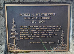 Bridge 14-0016, the St. Helena Bridge (LAK 006.31), is the "Robert H. "Bob" Weatherwax
Memorial Bridge". It was named in memory of Robert H.
‘‘Bob’’ Weatherwax, a resident of Middletown, Lake
County for 44 years, who died at the age of 66 in May 1996. During those
44 years, Mr. Weatherwax was appreciated by the entire community as a
willing volunteer and contributor in the efforts to develop and construct
the Cobb Mountain Elementary School. The Middletown Unified School
District recognized him for those efforts with a Certificate of
Appreciation in September 1985. Bob Weatherwax assisted in reviving and
renewing the Middletown Boosters Club for the Middletown Athletic Program.
Mr. Weatherwax’s efforts earned him a Certificate of Recognition in
1991 from Lake County as the Middletown Volunteer Citizen of the Year. Mr.
Weatherwax served as a past President of the Middletown Luncheon Club and
the Middletown Lions Club, and was a founder of the Middletown Merchants.
He donated land for the treatment plant now used by the Callayomi Water
District and served as head cook for the spring high school field trips
and chaperon for senior field trips, as well as many other unselfish acts
of serving the community he loved. Mr. Weatherwax was considered the
‘‘Honorary Mayor’’ of Middletown. Named by Senate
Concurrent Resolution 34, Chapter 71 in1997.
Bridge 14-0016, the St. Helena Bridge (LAK 006.31), is the "Robert H. "Bob" Weatherwax
Memorial Bridge". It was named in memory of Robert H.
‘‘Bob’’ Weatherwax, a resident of Middletown, Lake
County for 44 years, who died at the age of 66 in May 1996. During those
44 years, Mr. Weatherwax was appreciated by the entire community as a
willing volunteer and contributor in the efforts to develop and construct
the Cobb Mountain Elementary School. The Middletown Unified School
District recognized him for those efforts with a Certificate of
Appreciation in September 1985. Bob Weatherwax assisted in reviving and
renewing the Middletown Boosters Club for the Middletown Athletic Program.
Mr. Weatherwax’s efforts earned him a Certificate of Recognition in
1991 from Lake County as the Middletown Volunteer Citizen of the Year. Mr.
Weatherwax served as a past President of the Middletown Luncheon Club and
the Middletown Lions Club, and was a founder of the Middletown Merchants.
He donated land for the treatment plant now used by the Callayomi Water
District and served as head cook for the spring high school field trips
and chaperon for senior field trips, as well as many other unselfish acts
of serving the community he loved. Mr. Weatherwax was considered the
‘‘Honorary Mayor’’ of Middletown. Named by Senate
Concurrent Resolution 34, Chapter 71 in1997.
(Image source: Ingress intel)
The bridge located on Route 29 six miles north of Middletown, is named the "Frank and Elly Hartmann Bridge" (Bridge 14-0014, over Putah Creek, LAK 009.74). Named in honor of Frank and Elly Hartmann, who were pioneers in Middletown and the Coyote Valley area. They established and operated the Hartmann Ranch and many significant contributions to Middletown and the Coyote Valley area. Named by Senate Concurrent Resolution 45, Chapter 52, May 5, 2004.
 Exit Information
 Other WWW Links
 Scenic Route
[SHC 263.3] From Route 37 near Vallejo to Route 221 near Napa; and from the vicinity of Trancas Street in northwest Napa to Route 20 near Upper Lake.
 Classified Landcaped Freeway
The following segments are designated as Classified Landscaped Freeway:
| County | Route | Starting PM | Ending PM |
| Napa | 29 | 10.09 | 12.49 |
| Napa | 29 | 12.49 | 13.20 |
 National Trails
 According to an article in April 2017, the portion of Route 29 through American Canyon near I-80 was part of the "Lincoln Highway".
The somewhat tangled tale of how Napa County belatedly secured a section
of the Lincoln Highway has its roots a century ago with a bespectacled man
in Indiana named Carl Fisher. Fisher owned the Prest-O-Lite headlight
company and helped establish the Indianapolis Motor Speedway. In 1912, he
and other auto enthusiasts plotted a transcontinental route from New
York’s Times Square to San Francisco’s Lincoln Park. This
original, Napa-less coast-to-coast route for the most part stitched
together existing roads. A 1916 Lincoln Highway guidebook said motorists
should be able to make an enjoyable cross-country trip in 20 to 30 days,
as long as rain didn’t bog them down on the unpaved sections. The
westernmost section of the original Lincoln Highway went from Sacramento
to San Francisco by way of Stockton and the Altamont Pass to avoid water
barriers (i.e., former US 50). But in 1916, the completion of the Yolo
Causeway west of Sacramento removed one of those barriers. Napans began
hoping a more direct route might pass through the city of Napa, where
tourists would stop and spend money. By 1923, efforts to create an
alternate Lincoln Highway route focused on Vallejo, taking the city of
Napa out of the picture. That alternative route became a reality after the
Carquinez Bridge was completed in 1927 to take motorists over the
Carquinez Strait. This alternative Lincoln Highway segment extends west
from Sacramento using the same route as long-gone US 40. It goes through
Davis, Vacaville and Fairfield, and then through Jameson Canyon on
today’s Route 12, where it enters south Napa County. Until a few
years ago, most of this Jameson Canyon section was two lanes and narrow
and still had the ambiance of the old Lincoln Highway. Safety and traffic
congestion concerns led to the road being widened to a four lanes in 2014.
From Jameson Canyon, the Lincoln Highway heads south along what is now
Route 29 past the county industrial center and city of American Canyon.
Then, at American Canyon Road, it swings up to Broadway Street and heads
past today’s Veterans Memorial Park to enter Vallejo and Solano
County. Some in the Lincoln Highway Associate dispute that the alternate
Lincoln Highway route through Yolo, Solano and Napa counties is
legitimate. But Kinst said Gail Hoag, an official with the Lincoln Highway
Association, in 1928 authorized Boy Scouts to erect markers along it. Napa
County’s moment of Lincoln Highway sun soon faded, for all practical
purposes. The state in 1933 began building a new US 40 route that went
through the hills between Fairfield and Vallejo, creating a much more
direct route than the local Lincoln Highway. That route became
today’s I-80.
According to an article in April 2017, the portion of Route 29 through American Canyon near I-80 was part of the "Lincoln Highway".
The somewhat tangled tale of how Napa County belatedly secured a section
of the Lincoln Highway has its roots a century ago with a bespectacled man
in Indiana named Carl Fisher. Fisher owned the Prest-O-Lite headlight
company and helped establish the Indianapolis Motor Speedway. In 1912, he
and other auto enthusiasts plotted a transcontinental route from New
York’s Times Square to San Francisco’s Lincoln Park. This
original, Napa-less coast-to-coast route for the most part stitched
together existing roads. A 1916 Lincoln Highway guidebook said motorists
should be able to make an enjoyable cross-country trip in 20 to 30 days,
as long as rain didn’t bog them down on the unpaved sections. The
westernmost section of the original Lincoln Highway went from Sacramento
to San Francisco by way of Stockton and the Altamont Pass to avoid water
barriers (i.e., former US 50). But in 1916, the completion of the Yolo
Causeway west of Sacramento removed one of those barriers. Napans began
hoping a more direct route might pass through the city of Napa, where
tourists would stop and spend money. By 1923, efforts to create an
alternate Lincoln Highway route focused on Vallejo, taking the city of
Napa out of the picture. That alternative route became a reality after the
Carquinez Bridge was completed in 1927 to take motorists over the
Carquinez Strait. This alternative Lincoln Highway segment extends west
from Sacramento using the same route as long-gone US 40. It goes through
Davis, Vacaville and Fairfield, and then through Jameson Canyon on
today’s Route 12, where it enters south Napa County. Until a few
years ago, most of this Jameson Canyon section was two lanes and narrow
and still had the ambiance of the old Lincoln Highway. Safety and traffic
congestion concerns led to the road being widened to a four lanes in 2014.
From Jameson Canyon, the Lincoln Highway heads south along what is now
Route 29 past the county industrial center and city of American Canyon.
Then, at American Canyon Road, it swings up to Broadway Street and heads
past today’s Veterans Memorial Park to enter Vallejo and Solano
County. Some in the Lincoln Highway Associate dispute that the alternate
Lincoln Highway route through Yolo, Solano and Napa counties is
legitimate. But Kinst said Gail Hoag, an official with the Lincoln Highway
Association, in 1928 authorized Boy Scouts to erect markers along it. Napa
County’s moment of Lincoln Highway sun soon faded, for all practical
purposes. The state in 1933 began building a new US 40 route that went
through the hills between Fairfield and Vallejo, creating a much more
direct route than the local Lincoln Highway. That route became
today’s I-80.
(Source: Napa Valley Register, 4/1/2017)
 Freeway
[SHC 253.3] From Route 80 near Vallejo to Oak Knoll Avenue north of the City of Napa; and from the Napa-Lake county line to Route 20. The portion from Route 121 to north of Napa and from Route 175 to north of Lakeport is constructed to freeway standards.
As for the timing of the additions to the F&E system, the 1959 statutes used the older route numbers, so it is harder to follow given a route as disjointed as this. It is clear that the 1959 Chapter 1062 defined the portion between Vallejo and Route 221 S of Napa, and the portion from Napa to Upper Lake as part of the F&E system. By 1963, all of the original definition of Route 29 was considered Freeway and Expressway. Chapter 998 in 1971 deleted the segment from Oak Knoll Avenue to the Napa-Lake County Line from the Freeway and Expressway system.
On 7/18/1974, the freeway routing between Yountville and Calistoga was rescinced, per CHC Resolution HRU 74.3:
the California Highway Commission, by resolutions dated September 20, 1955, September 27, 1960 and July 22, 1953 established a freeway location on State Highway Route 29 in Napa County from 1 mile south of Yountville to Calistoga and;
the Legislature at its 1971 Session deleted from the California Freeway and Expressway System the unconstructed portion of Route 29 from 1 mile north of' Yountville to 3 miles south of Calistoga; now, therefore
BE IT RESOLVED, that the California Highway Commission declares that the presently maintained location between 1 mile north of Yountville and 3 miles south of Calistoga shall be the only established location for Route 29; and
BE IT FURTHER RESOLVED that the Department of Transportation is directed and authorized to dispose of rights of way previously acquired for freeway purposes on said segment of Route 29 from 1 mile north of Yountville to 3 miles south of Calistoga.
In 1984, a new freeway bypass was created in Napa, and with the changes involved with the redefinition of Route 121 and Route 221, the portion from Route 221 S of Napa to Route 121 in Napa was added (Chapter 409).
 Interregional Route
[SHC 164.11] Entire route.
 Statistics
Overall statistics for Route 29:
 Pre-1964 Legislative Route
The route that would become LRN 29 was originally defined in the 1909 First Bond Act running from Red Bluff to Susanville. In 1919, the Third Bond Act extended the route from Susanville to the Nevada State Line. In 1933, it was extended further, from [LRN 35] to [LRN 3] near Red Bluff. It was codified in the 1935 state highway code as:
This was primary state highway from Red Bluff to Susanville.
This definition remained until the 1964 signed/legislative route alignment. Signage was as follows:
This was signed as Route 36 between Red Bluff and Susanville.
LRN 29 was signed as US 395 between Susanville and the Nevada border (it was briefly cosigned with Alt US 40 from 6 mi E of Chilcoot to the Nevada border).
This was signed as Route 36, and ran from the present day Route 3/Route 36 junction (LRN 35) to US 99 (LRN 3).
© 1996-2020 Daniel P. Faigin.
Maintained by: Daniel P. Faigin
<webmaster@cahighways.org>.
 Route 28
 Route 30