
 California Highways:
Click here for a key to the symbols used. An explanation of acronyms may be found at the bottom of the page.
 Routing
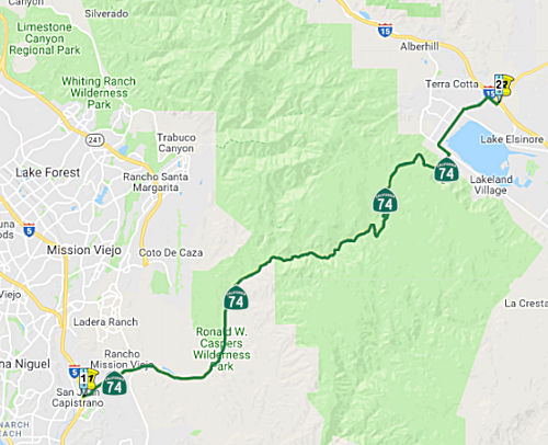 (a)(1) From Route 5 near San Juan Capistrano to Route 15 near Lake Elsinore.
 Post 1964 Signage History
In 1963, this segment was defined as the route from "Route 5 near San Juan Capistrano to Route 71."
This segment was originally planned as freeway within Orange County and Riverside County in 1965.
In 1976, Chapter 1354, changed "Route 71" to "Route 15", reflecting the establishment of the route of the real I-15, and the renumbering of the old I-15 as I-15E (Route 194)
In 1986, Chapter 928 clarified the terminus of this segment to be "Route 15 near Lake Elsinore."
In 2008, Chapter 635 (AB 1915, 9/30/2008) authorized the relinquishment of the portion within the City of Lake Elsinore with the usual language:
(1) The commission may relinquish to the City of Lake Elsinore the portion of Route 74 located within the city limits of that city, upon terms and conditions the commission finds to be in the best interests of the state.
(2) Any relinquishment agreement shall require that the City of Lake Elsinore administer the operation and maintenance of the highway in a manner consistent with professional traffic engineering standards.
(3) Any relinquishment agreement shall require the City of Lake Elsinore to ensure that appropriate traffic studies or analyses will be performed to substantiate any decisions affecting the highway.
(4) Any relinquishment agreement shall also require the City of Lake Elsinore to provide for public notice and the consideration of public input on the proximate effects of any proposed decision on traffic flow, residences, or businesses, other than a decision on routine maintenance.
(5) Notwithstanding any of its other terms, any relinquishment agreement shall require the City of Lake Elsinore to indemnify and hold the department harmless from any liability for any claims made or damages suffered by any person, including a public entity, as a result of any decision made or action taken by the City of Lake Elsinore, its officers, employees, contractors, or agents, with respect to the design, maintenance, construction, or operation of that portion of Route 74 that is to be relinquished to the city.
(6) A relinquishment under this subdivision shall become effective immediately after the county recorder records the relinquishment resolution that contains the commission's approval of the terms and conditions of the relinquishment.
(7) On and after the effective date of the relinquishment, both of the following shall occur: (A) The portion of Route 74 relinquished shall cease to be a state highway. (B) The portion of Route 74 relinquished may not be considered for future adoption under Section 81.
(9) For relinquished portions of Route 74, the City of Lake Elsinore shall maintain signs directing motorists to the continuation of Route 74.
 Pre 1964 Signage History
In 1934, Route 74 was signed along the route from Jct. US 101 at San Juan Capistrano to Jct. Route 740 at Perris. The portion from Jct. Route 71 (US 395) to Perris may have been signed US 395. Route 740 was later renumbered as an eastern extension of Route 74. It was LRN 64, and was defined in 1933.
The Ortega Highway built by Orange County and Riverside County beginning
in 1929 which concluded in 1933.
(Source: Gribblenation Blog "California State Route 74; the Pines to Palms Highway", a/o 11/23/2019)
 Status
Route 74/I-5 Interchange Improvements
In December 2005, the OCTA, using Measure M money, authorized widening the I-5/Route 74 (ORA 0.000) interchange and widening at San Antonio Parkway. However, they eliminated from consideration plans to widen Route 55, into which Route 91 feeds, and to widen Ortega Highway (Route 74) in South County.
In July 2010, the CTC approved for future consideration of funding a project that would construct interchange improvements on Route 74 at I-5 (the I-5/Ortega Highway interchange) near the city of San Juan Capistrano. The project is programmed in the 2010 State Transportation Improvement Program and includes local funds. Construction is estimated to begin in FY 2012-13. Total estimated project cost is $84,514,000 for capital and support.
In June 2015, it was reported that work on the
Interstate 5 (I-5)/Ortega Highway Interchange Improvement Project is 80%
complete, and the project is expected to wrap up sometime in late 2015.
The $86 million project, which began construction in February 2013, widens
the Ortega Highway bridge as well as the existing ramps and adds a loop
on-ramp to northbound I-5. The project also realigns Ortega Highway to
curve into Del Obispo Street. This will improve traffic flow on Ortega
Highway as well as ease regional commutes. The deck for the second half of
the new bridge was poured at the end of May 2015. The wood forms
supporting the structure are set to be removed by late June or early July.
Concrete pours to fill the small gap between the north and south sides of
the bridge are scheduled for mid- to late July 2015. In late June,
motorists will see crews placing white foam blocks at the southbound I-5
off-ramp to Ortega. These strong, lightweight blocks, known as geofoam,
are used as fill for the ramp, taking the place of dirt, which requires
time to compact. The northbound on-ramp and the remaining portion of the
southbound off-ramp are scheduled to be paved by the end of July, but they
won’t open until the bridge opens in late August or early September
2015.
(Source: OCTA, 6/16/2015)
In September 2015, it was reported that construction
was completed on the Ortega Highway interchange with I-5. The California
Department of Transportation and the Orange County Transportation
Authority began improvements on the intersection of Ortega Highway and I-5
in February 2013 to relieve traffic congestion around San Juan
Capistrano’s primary connection to the freeway. The $81 million
project was finished the first week of September 2015 with improved
traffic flow and freeway access. Construction included remodeling the
bridge over the freeway, widening on- and off-ramps and a new northbound
on-ramp loop. The new plans also smoothed out the traffic flow west of the
freeway by making Ortega Highway lead into Del Obisbo street and
diminishing two intersections to one.
(Source: OC Register, 9/9/2015)
In August 2011, the CTC approved $7,130,000 in SHOPP funding for repairs in San Juan Capistrano, from Route 5 to Calle Entradero Drive (~ORA 0.000 to ORA 1.064); also at PM ORA 3.0/13.3 from west of Antonio Parkway to west of Hot Springs Canyon Road, that will rehabilitate 24.6 lane miles of pavement to improve safety and ride quality.
Lower Ortega Highway Widening (12-Ora-74, PM 1.0/2.1)
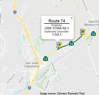 Caltrans also has plans to widen lower Ortega Hwy (Route 74). The existing
alignment consists of four through lanes from I-5 to approximately 330
feet (ft.) east of Calle Entradero where it transitions to two through
lanes. The proposed project would widen Route 74 from two lanes to four
through lanes from Calle Entradero (PM 1.0) in the City of San Juan
Capistrano to the City/County line at PM 1.9. Route 74 was constructed
circa 1930/32 from plans prepared for Joint Highway District 15. The road
was originally designed to be two lanes; each lane being 31 ft. (6.7 m)
wide with a maximum grade of 6%, for vehicle speeds of 25 miles per hour
(mph) to 40 mph. In 1959, this route was included within the State Freeway
and Expressway System. The project would involve some alignment shifts,
construction of retaining walls, and clear soundwalls. Detail can be found
in the EIR. Construction for this project would be expected to start in mid-2009 and
be completed in the winter of 2011. The basic widening would occur
primarily on the north side of Route 74 to minimize removal of mature
trees and the existing sidewalk on the south side. Currently, there are
two 12-ft. lanes in each direction and no median throughout the project
area. The construction would provide one additional 12-ft. wide lane in
each direction, as well as a 12-ft. wide painted median. A 5-ft.-wide
paved shoulder would be provided on each side of the roadway to
accommodate striped on-road bicycle facilities, except from Avenida Siega
to the City/County limits where it would transition to an 8-ft.-wide
shoulder to merge with the County portion of the project. The edge of the
pavement would have concrete curbs on each side of the roadway.
Caltrans also has plans to widen lower Ortega Hwy (Route 74). The existing
alignment consists of four through lanes from I-5 to approximately 330
feet (ft.) east of Calle Entradero where it transitions to two through
lanes. The proposed project would widen Route 74 from two lanes to four
through lanes from Calle Entradero (PM 1.0) in the City of San Juan
Capistrano to the City/County line at PM 1.9. Route 74 was constructed
circa 1930/32 from plans prepared for Joint Highway District 15. The road
was originally designed to be two lanes; each lane being 31 ft. (6.7 m)
wide with a maximum grade of 6%, for vehicle speeds of 25 miles per hour
(mph) to 40 mph. In 1959, this route was included within the State Freeway
and Expressway System. The project would involve some alignment shifts,
construction of retaining walls, and clear soundwalls. Detail can be found
in the EIR. Construction for this project would be expected to start in mid-2009 and
be completed in the winter of 2011. The basic widening would occur
primarily on the north side of Route 74 to minimize removal of mature
trees and the existing sidewalk on the south side. Currently, there are
two 12-ft. lanes in each direction and no median throughout the project
area. The construction would provide one additional 12-ft. wide lane in
each direction, as well as a 12-ft. wide painted median. A 5-ft.-wide
paved shoulder would be provided on each side of the roadway to
accommodate striped on-road bicycle facilities, except from Avenida Siega
to the City/County limits where it would transition to an 8-ft.-wide
shoulder to merge with the County portion of the project. The edge of the
pavement would have concrete curbs on each side of the roadway.
In August and September 2008, the CTC considered splitting the widening in San Juan Capistrano into two projects. As noted above, the project proposes to widen Route 74, in and near San Juan Capistrano, by adding one lane in each direction. This will eliminate traffic bottlenecks between Calle Entradero and the San Juan Capistrano city limits and will improve the general traffic flow within the project limits. The limits of the project extend approximately one mile inside and one mile outside the city limits of San Juan Capistrano. The segment outside the city limits (the Orange County segment) has obtained environmental clearance and is ready for construction as of August 2008. Environmental clearance for the segment within the city limits has been delayed due to the need for additional environmental studies. Orange County would like to proceed with construction of the segment outside the city limits. Therefore, it is proposed to split the project into two segments, a city segment and a county segment, as follows:
In March 2020, the CTC approved the 2020 STIP, which
included programmed funding for PPNO 4110 "Ortega Hwy, Calle
Entradero-City/Co line, widen (RIP)" of $8,540K in FY24-25.
(Source: March 2020 CTC Agenda, Item 4.7, 2020 STIP
Adopted 3/25/2020)
In June 2020, the CTC approved for future consideration
of funding 12-Ora-74, PM 1.0/2.1 Route 74 Lower Ortega Highway
Widening Project. Widen Route 74 from two lanes to four lanes in
Orange County. (FEIR) (PPNO 4110) (STIP). The project is located in the
City of San Juan Capistrano in Orange County and would widen Route 74 by
adding one through lane in each direction, east and west bound, from Calle
Entradero to the eastern City of San Juan Capistrano City limits. This
project is currently programmed in the 2020 State Transportation
Improvement Program (STIP) for $8,540,000 for Plans, Specifications &
Estimate only. Specifically, the project proposes to widen Route 74 from
two lanes to four lanes from Calle Entradero (Post Mile [PM] 1.0) to 150
feet (ft.) east of the City/County boundary (PM 1.9) with restriping from
150 ft. east of the City/County boundary to Reata Road (PM 2.1). The
project will provide one additional 12 ft. lane in each direction, and a
12 ft. painted median at the western portion within the project limits. In
addition, a paved 5 ft. and 8 ft. shoulder will be provided on each side
of the roadway to accommodate Class II (striped on-road) bicycle
facilities. The shoulder will be 8 ft. wide from Avenida Siega to the
City/County boundary limits to merge with the completed county portion.
The total estimated project cost is $75,713,000. Depending on the
availability of funding, construction is estimated to begin Fiscal Year
2023-2024. The scope, as described for the preferred alternative, is
consistent with the project scope programmed by the Commission in the 2020
STIP. Due to the time lapse between the original EIR and the current
request for future funding, a revalidation of the EIR was also required.
Resources that may be impacted by the project include community character,
and visual and aesthetics.
(Source: June 2020 CTC Agenda, Agenda Item
2.2c.(14))
In May 2021, it was reported that OCTA approved an
agreement with San Juan Capistrano to provide $5.25 million in OC Go
funding for the preparation of plans, specifications and estimates to
widen the portion of Ortega Highway. That stretch of Ortega Highway is
currently one lane in each direction between Calle Entradero and Reata
Road, and a notorious choke point for traffic near the eastern end of San
Juan Capistrano. The project calls widening it from one lane to two lanes
in each direction. OCTA is working on a funding agreement for the Ortega
Highway project, which could open by 2028, with funding contributions from
the County of Orange, San Juan Capistrano, the state and OCTA.
(Source: OCTA Blog, 5/20/2021)
In June 2021, the CTC approved amending the STIP to use
the funding available through the 2021 Mid-Cycle STIP and share
distribution of the federal Coronavirus Response and Relief Supplemental
Appropriations Act of 2021 funds (COVID Relief Funds) to advance funding
for a project already in the STIP as follows: from FY 2024-25 to 2021-22
for the Route 74 (Ortega Highway) Calle Entradero-City/County Line Project
(PPNO 4110); $800K in PS&E phase.
(Source: June 2021 CTC Agenda, Agenda Item
2.1a.(19))
In October 2023, the CTC approved for consideration of
funding the following project for which a FEIR and an Addendum have been
completed: Route 74 in Orange County. Widen Route 74 from two lanes to
four lanes, from Calle Entradero to the City of San Juan Capistrano, in
Orange County. (12-Ora-74, PM 1.0/1.9; PPNO 4110). The project is
currently programmed in the 2022 STIP for a total of $75,713,000, which
includes Right of Way (Capital) and Construction (Capital). Construction
is estimated to begin in 2025-26. The scope, as described for the
preferred alternative, is consistent with the project scope as programmed
by the Commission in the 2022 STIP. A copy of the FEIR has been provided
to Commission staff. The Commission approved the project for future
consideration of funding on June 24, 2020, under Resolution E-20-55. Since
the approval of the FEIR, there have been changes to the project and an
Addendum was prepared pursuant to CEQA. These changes include the
construction of a traffic signal at Via Cordova/Hunt Club Drive and the
reconstruction of the meandering sidewalk on the north side of Ortega
Highway. Additional mitigation measures related to noise and
visual/aesthetics were also incorporated into the project. Changes to
potential impacts to environmental resources are described in detail in
the Addendum. These changes, however, do not result in new significant
environmental effects or a substantial increase in the severity of effects
reported in the environmental document. The project changes do not meet
the criteria outlined in CEQA Guidelines Section 15162 and Section 15163
to prepare a Subsequent or Supplemental FEIR. The Department subsequently
completed an Addendum to the FEIR pursuant to CEQA. The Department has
approved this project for construction. This approval and the Addendum
will satisfy the environmental requirements for this stage of the planning
process.
(Source: October 2023 CTC Agenda, Agenda Item 2.2c.(4))
In October 2023, the CTC approved the following STIP
allocation: $9,979,000. 12-Ora-74 1/2.1. PPNO 12-4110; ProjID 1200000051;
EA 08692. SR-74 Gap closure and multimodal improvements. This
project will provide a gap closure on Route 74/Ortega Highway which will
eliminate an existing choke point in the City of San Juan Capistrano
between Calle Entradero and Reata Road. The project will include a five-
to eight-foot shoulder in each direction to accommodate Class II bicycle
lanes, sidewalk reconstruction, cross-walk re-striping, a new traffic
signal at Via Cordova and Hunt Club Drive, and providing a 12-foot wide
striped median. The project also includes seven retaining walls. CEQA -
EIR, 11/30/2009. NEPA - FONSI, 05/07/2020. Future consideration of funding
approved under Resolution E-20-55; June 2020. Contribution from other
sources: $0. The RIP savings of $521,000 will be returned to Orange County
shares. A revised Right of Way Data Sheet was completed in December 2022
reducing the R/W capital estimate to $9,979,000. Concurrent addendum for
the previously approved Future Consideration of Funding under Resolution
E-23-138A; October 2023. Allocation: R/W $10,500,000 $9,979,000.
This project is located on Route 74, in the City of San Juan Capistrano,
in Orange County, from Calle Entradero to the City/County line. The
project proposes to widen the existing highway to four lanes with
shoulders and a median. The pavement will also be restriped and restored
from the City/County line to Reata Road. The project scope requires
acquisitions from 46 residential and residential-agricultural parcels
adjacent to Route 74. Five parcels require the acquisition of fee,
permanent easements, and temporary construction easements. Forty-one
parcels require permanent easements and/or temporary construction
easements. Although there are no residential displacements planned, some
parcels will include cost to cure payments to mitigate the impact of the
acquisition. A total of 125 utility facilities have been identified within
the project limits. Fifty-three will be relocated or redesigned to meet
current standards. The Department will coordinate with multiple agencies
to address permanent water, sewer, electric, and gas conflicts. Although
the programmed amount is $10,500,000, a revised RW Data Sheet was
completed in December 2022 reducing the RW capital estimate to $9,979,000.
(Source: October 2023 CTC Agenda, Agenda Item 2.5c.(1))
In March 2024, the CTC adopted the 2024 STIP, which
included the following as new 2024 programming: Route 74 (PPNO 12-4110;
12-Ora-74 1/2.1) "SR74 Gap Closure & Multimodal Impvts,
Entradero-Reata ". Programming × $1000: $37,600. It appears to be a
change in title only, from "Ortega Hwy, Entradero-Reata, close
gap/multimodal (SB1)" to "SR74 Gap Closure & Multimodal Impvts,
Entradero-Reata"
(March 2024 CTC Agenda, Agenda Item 4.5 and Caltrans STIP Page)
In March 2026, the CTC adopted the 2026 STIP, which
included the following as continued programming from 2024: PPNO 12-4110,
“Ortega Hwy, Entradero-Reata, close gap/multimodal (SB1)”.
Total Programmed ($ × 1000): $27,100. Prior years programming ($
× 1000): $2,500. 2026 and Future Programming ($ × 1000): $24,600
FY26-27. Programming Breakdown ($ × 1000): $0 (PA&ED), $0
(PS&E), $17,800 (Const), $6,800 (Con Sup), $0 (R/W), $2,500 (R/W Sup).
(Source: March 2026 CTC Agenda, Agenda Item 4.4; 2026 STIP Staff Recommendations Adopted 2/27/2026)
In March 2014, the CTC approved for future consideration of funding a project in Orange County near Laguna Niguel (12-Ora-74, PM 2.93/5.06) that will widen shoulders, install rumble strips, construct turn-outs, and install guard rails at various locations along a portion of Route 74.
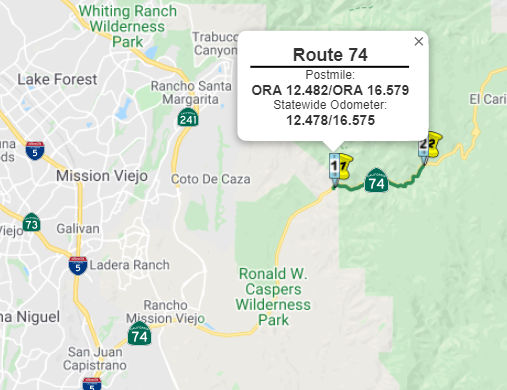 In 2007, work was begun on the Caltrans Ortega Highway
Safety Improvement Project, which involves a three-mile section from San
Juan Hot Springs and the Orange County line (~ ORA 12.482 to ORA 16.579).
This stretch of road has a section of narrow lanes, limited turn-out areas
and high accident rates. The project will add 4-foot shoulders to each
side of the highway, add safety enhancements to reduce road closures due
to rock slides, place rumble strips in the median, improve sight distances
by removing protruding rock walls, widen the existing 10-foot lanes to
standard 12-foot lanes, improve drainage facilities into San Juan Creek,
and improve turnouts and add two new turnouts, one in each direction. This
project was completed in 2008.
In 2007, work was begun on the Caltrans Ortega Highway
Safety Improvement Project, which involves a three-mile section from San
Juan Hot Springs and the Orange County line (~ ORA 12.482 to ORA 16.579).
This stretch of road has a section of narrow lanes, limited turn-out areas
and high accident rates. The project will add 4-foot shoulders to each
side of the highway, add safety enhancements to reduce road closures due
to rock slides, place rumble strips in the median, improve sight distances
by removing protruding rock walls, widen the existing 10-foot lanes to
standard 12-foot lanes, improve drainage facilities into San Juan Creek,
and improve turnouts and add two new turnouts, one in each direction. This
project was completed in 2008.
There are regional transportation improvement plans to widen the portion of Route 74 in Orange County. There are also rumors that a tunnel might be constructed to replace Route 74 (or supplement it) to improve transportation in the Orange-Riverside County corridor. Current discussions propose a triple tunnel, dug for 10 to 14 miles beneath the Santa Ana Mountains - and the Cleveland National Forest - north of Camp Pendleton. The estimated cost would be $3.6 Billion. See Route 91 for more information. (~ ORA 12.689 to RIV 11.468)
Ortega Highway Widening (Riverside County - 08-Riv-74, PM 0.0/5.8)
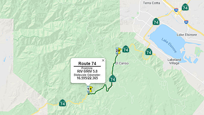 In October 2019, the CTC had on its agenda the following project for future
consideration of funding: 08-Riv-74, PM 0.0/5.8 Route 74 in Riverside
County. Construct roadway improvements on a portion of Route 74 near Lake
Elsinore in Riverside County. (PPNO 0050P). This project is located on
Route 74 near Lake Elsinore, in Riverside County. This project proposes to
widen the roadway to standard lane widths and shoulders, and construct
ground in rumble strips. Widening the shoulders would require constructing
retaining walls with concrete barriers, cutting the rock slopes, and
installing fill slopes. This project is fully funded and currently
programmed in the 2018 SHOPP for construction capital and construction
support. Construction was projected to begin in 2018. The scope, as
described for the preferred alternative, is consistent with the project
scope programmed by the Commission in the 2018 SHOPP.
In October 2019, the CTC had on its agenda the following project for future
consideration of funding: 08-Riv-74, PM 0.0/5.8 Route 74 in Riverside
County. Construct roadway improvements on a portion of Route 74 near Lake
Elsinore in Riverside County. (PPNO 0050P). This project is located on
Route 74 near Lake Elsinore, in Riverside County. This project proposes to
widen the roadway to standard lane widths and shoulders, and construct
ground in rumble strips. Widening the shoulders would require constructing
retaining walls with concrete barriers, cutting the rock slopes, and
installing fill slopes. This project is fully funded and currently
programmed in the 2018 SHOPP for construction capital and construction
support. Construction was projected to begin in 2018. The scope, as
described for the preferred alternative, is consistent with the project
scope programmed by the Commission in the 2018 SHOPP.
In December 2020, it was reported that Granite
Construction had been awarded the Route 74 Ortega Highway Widening Project
by the California Department of Transportation (Caltrans) in Lake
Elsinore, California. The $39 million contract is anticipated to be
included in Granite’s fourth quarter 2020 backlog. This project will
widen Route 74 from the Riverside County/Orange County line to Lake
Elsinore. Granite’s scope of work includes the construction of
widened shoulders and rumble strips in each direction, as well as
increased super-elevations on the curves for added safety. Construction is
expected to begin in February 2021 and expected to conclude in June 2022.
(Source: Business Wire, 12/1/2020)
In February 2021, it was reported that the $49 million
project to expand the Route 74 (Ortega Highway) between the Orange County
Line and Monte Vista Street just W of Lake Elsinore was starting in late
February 2021. The State Route 74 Widening Project will consist of
Watsonville-based Granite Construction Inc. making a series of
modifications intended to enhance safety along the two-lane corridor. The
work will begin with excavation in preparation for widening existing
westbound and eastbound lanes to 12 feet, as well as expanding shoulders
on both sides to four feet. Crews will also install in-ground rumble
strips for the highway centerline and shoulders. The project is scheduled
to be completed in early 2025.
(Source: Lake Elsinore Patch, 2/16/2021)
In July 2021, it was reported that construction is in
progress on the Ortega Highway widening, including full closures of the
highway. During the closures people won’t be able to drive across
the forest between Riverside and Orange counties; they will have to take
another route such as Route 91. Passes issued to mountain community
residents no longer will be valid and no one will be allowed to drive
through the work zone. The closures stem from a four-year, $49 million
project Caltrans launched in late winter 2021 to make driving conditions
safer along 6 miles of the road. Crews continue to remove trees and shrubs
to clear a path for the improvements, which will extend from Monte Vista
Street just west of Lake Elsinore to the Riverside-Orange county line. The
project involves widening the travel lanes to 12 feet, constructing
4-foot-wide shoulders and installing rumble strips in the center and on
the sides.
(Source: Press Enterprise, 7/3/2021)
In October 2022, the CTC approved a request for an
additional $2,064,000 in Construction Support for the SHOPP Safety
Improvements project on Route 74, in Riverside County, to complete the
construction contract. The project (08-Riv-74 0/5.8; PPNO 08-0050P; ProjID
0813000047; EA 1C850) is located on Route 74 near Lake Elsinore, from the
Orange County Line to Monte Vista Street, in Riverside County. The project
will widen the roadway for standard lane widths and shoulder and construct
ground-in rumble strips. In February 2021, construction began with 500
working days. In March 2022, the project received G-12 funds in the amount
of $780,000. The remaining funds are currently at $922,000 in Construction
Support. The project is 60 percent complete with 190 working days
remaining. The planned Construction Contract Acceptance is scheduled for
February 2025. The project realized cost increases due to differing site
conditions and man-made buried objects, traffic control revisions, survey
re-staking, unanticipated conflicts between drainage systems and retaining
wall anchors, and issues with the storage and removal of vegetation. The
project encountered unexpected layers of rocks throughout the project
limits when excavating the cut slopes for shoulder widening. These
differing site conditions required design changes. In addition, unknown
man-made buried objects were encountered throughout the project site
consisting of guard rail that was used for earth retaining purposes. An
existing utility water line that was not identified on the contract plans
was also encountered during excavation activities, which required
coordination with the local water district to relocate it. The project
included 55-hour closures to complete some of the work, but additional
closures were incorporated to be able to combine three construction stages
into one. This allowed paving operations to be completed more efficiently
and eliminated the need for temporary concrete barriers. In addition,
adjustments were made to night closures to ensure that continuous access
was provided for the local community. The project is located in a
mountainous area within the United States Forest Service (USFS)
jurisdiction. However, the Department’s survey crews were unable to
access and complete the staking work at various locations that were needed
to begin construction, due to the steepness of and vegetation on the
slopes. Although the survey crews had provided original staking for rough
grades, it required the contractor to clear the areas in order to provide
access for the survey crews to re-stake the area to ensure final grades
were provided to the contractor. This additional effort resulted in an
increase to the support cost. The contractor encountered unanticipated
conflicts with the retaining wall anchors and drainage systems at multiple
locations. This required the drainage systems to be redesigned to fit the
field conditions, which necessitated re-staking by the survey crews. The
redesigned drainage systems required more structure backfill than
originally anticipated, which translated into more material testing to
ensure proper compaction. There was a change in the storage area for the
natural topsoil which added 26 working days in the schedule, as the
original area was not approved by the USFS. This also required additional
support resources to find another location to store the material.
Furthermore, additional tree removal was required than what was specified
in the contract plans, this doubled the efforts on the tree removal needed
from the project site, and increased the oversight needed by the
Department’s landscape crew to inspect the work.
(Source: October 2022 CTC Agenda, Agenda Item
2.5e.(13))
In October 2023, the CTC approved the following
supplemental allocation: $4,250,000. 08-Riv-74 0/5.8. PPNO 08-0050P;
ProjID 0813000047; EA 1C850. Route 74 Near Lake Elsinore, from the Orange
County line to Monte Vista Street. Outcome/Output: Widen for standard lane
widths and shoulders and construct ground-in rumble strips. Supplemental
funds are needed to Complete Construction. CEQA - MND, 5/31/2019;
Re-validation 4/15/2020 NEPA - FONSI, 5/31/2019; Re-validation 4/15/2020
Future consideration of funding approved under Resolution E-19-85; October
2019. Total revised amount $51,135,100. The project realized cost
increases due to additional pavement surface profile and cross slope
adjustments than was anticipated and the related traffic control measures.
The project impacted more trees than anticipated and differing site
conditions were encountered during the construction of the concrete
barrier footing. The project also encountered severe weather events in the
winter season of 2022-23 requiring unanticipated repair to the temporary
erosion control measures. In addition, there was a cost increase to the
asphalt concrete due to the fluctuation in oil prices. All of these
increases required additional time-related overhead. The project plans
required constructing a new profile and adjusting the cross slope of the
roadway for the curve locations. These adjustments required milling the
existing roadway up to a maximum specified depth to construct the new
proposed profile. However, a significant increase in the milling depth was
required. To mitigate this increase, the proposed profile was redesigned
and as a result the additional milling depth was minimized but was still
above the maximum specified depth. As a result of the increased depth, the
cost for milling increased by $900,000. This increase in pavement milling
led to an increase in traffic control. This change included six additional
55-hour lane closures. Additional flaggers and a pilot car were also
utilized for public safety and convenience during the full night and
weekend closures. Additional traffic control measures were required to
maintain traffic during severe weather events that jeopardized the
roadside slopes. These weather events required multiple pothole repairs
and pavement patching. This amounted to an increase of $700,000 for the
traffic control bid items. The roadway widening work required tree removal
along the project limits. Mitigation and plant establishment require an
initial tree count survey be conducted as part of project development. The
initial tree count survey was conducted in 2017. Due to the steepness of
the slopes and thick vegetation, staff were unable to access locations to
obtain an accurate tree count. As a result, staff had to rely on aerial
visuals to obtain an approximate number. After the final survey was
completed in May 2023, additional trees were identified for partial or
full removal. During construction, tree removal monitoring was required by
the United States Forest Service and included an arborist, biologist, and
forester. There were also associated costs for the tree removal that
included processing them for use as permanent erosion control. The
increase amount of tree removal and associated work amounted to an
increase of $400,000. The project also includes the construction of
concrete barriers. During the construction of the footing for the concrete
barriers, hard rock and boulders were encountered during the excavation.
This was not anticipated per the geotechnical report and boring log test.
The differing site condition slowed the production of the footing
excavation and required additional concrete forms. This amounted to an
increase of $600,000 to the concrete barrier work. The severe weather that
was encountered during construction from December 2022 through March 2023,
resulted in significant damage to the temporary erosion control measures
that were in place. The rainfall during this period was 250 percent above
the average for this location. The temporary erosion control measures had
to be replaced multiple times. The damage also required additional
permanent erosion control to stop water seepage from cut slopes. These
activities amounted to an increase of $300,000. The cost of asphalt
concrete encountered a significant increase due to the fluctuation of the
oil prices from the time of bid opening to the time of paving the roadway.
The fluctuation of the price amounted to an increase of $750,000. In
addition, time-related overhead increased in the amount of $600,000 as a
result of the additional work.
(Source: October 2023 CTC Agenda, Agenda Item 2.5e.(14))
In June 2024, the CTC approved a request for an
additional $5,700,000 (13.2% increase) in Construction Capital for the
SHOPP Safety Improvements project on Route 74, in Riverside County. (EA
1C850, PPNO 0050P). This project is located on Route 74 near the City of
Lake Elsinore, from the Orange County Line to Monte Vista Street, in
Riverside County. The project will widen the roadway to provide standard
lane and shoulder widths and construct ground-in rumble strips. In June
2014, the project was programmed for $53,600,000 in Construction Capital
in the SHOPP for allocation in Fiscal Year 2017-18. In May 2017, the
project was amended to move the construction allocation to 2019-20, due to
the federal land transfer process. In May 2020, the project was allocated
for $53,996,000 in Construction Capital. In November 2020, the project was
awarded for $43,285,000 in Construction Capital. In February 2021,
construction began with 500 working days. In August 2021, the project
received partial G-12 funding in the amount of $2,000,000 in Construction
Capital. In September 2022, the project received partial G-12 funding in
the amount of $1,600,000 in Construction Capital. In October 2023, the
project received supplemental funds in the amount of $4,250,000 in
Construction Capital. The project also received a 27-month project
completion time extension for the Construction phase. The remaining funds
are currently at $4,412,000 in Construction Capital. The project is 95
percent complete, with 100 working days remaining. The planned
Construction Contract Acceptance is scheduled for February 2026. This
project includes 360 working days for plant establishment. In October
2023, supplemental funds were approved to address additional pavement
surface profile and cross slope adjustments than was anticipated, along
with related traffic control measures. Adding to the cost was an increase
to the number of trees impacted by construction activities and
encountering differing site conditions for the concrete barrier footing.
The project also encountered severe weather events during the Winter
season of 2022-23 requiring unanticipated repair to the temporary erosion
control measures. All of these cost increases resulted in additional
time-related overhead. In addition, there was a cost increase to the
asphalt concrete due to the fluctuation in oil prices. Additional project
costs above the initial supplemental request were realized due to multiple
issues with guardrail installation, differing site conditions for storm
water treatment systems, and placement of larger than anticipated mulch
quantities. In addition, concrete barriers that were not installed at the
standard height required replacement. These increases required additional
enhanced traffic control and time-related overhead.
The project plans require upgrading guardrail at various locations.
Various issues were encountered at a few of the locations. After the
paving operation was completed for the project and prior to the
installation of guardrail, it was discovered that the pavement width at
two guardrail locations on a horizontal curve needed to be extended an
additional three feet to allow for the proper installation of the
guardrail and to meet sight distance requirements. There was a discrepancy
between the plans and survey staking that resulted in extending the
pavement. Differing site conditions, which consisted of a hard rock layer
and boulders, were encountered at various locations where guardrail posts
were to be installed. This operation is still ongoing, requires different
installation techniques, and is extremely slow to install.
(Source: June 2024 CTC Agenda, Agenda Item 2.5e.(10))
In February 2025, it was reported that Granite
Construction has inked an $88 million contract to improve a stretch of
winding, mountainous highway in Southern California. The project's scope
includes widening the shoulders and roadway while making room for
centerline and edge line rumble strips to improve safety on the two-lane
road. The section of the thoroughfare Granite will work on in this project
winds through the Santa Ana Mountains. The highway traverses a hairpin
turn that opens up to views of Lake Elsinore in Riverside County. Granite
expects to begin construction in April 2025, with a projected completion
date of November 2026.
(Source: Construction Dive, 2/4/2025)
SR-74 Bridge Replacement Project: Morrill Canyon Bridge (08-Riv-74, PM 2.9/3.2)
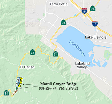 In May 2021, the CTC approved for future consideration of funding the following project:
08-Riv-74, PM 2.9/3.2. SR-74 Bridge Replacement Project. Replace
Morrill Canyon Bridge on Route 74 in Riverside County. (MND) (PPNO 3005Q)
(SHOPP). This project is located along Route 74 near Lake Elsinore in
Riverside County. The Department to proposes to replace Morrill Canyon
Bridge (Bridge No. 56-0169 Post Mile 3.08) near Lake Elsinore on Route 74
in Riverside County. The bridge has non-standard lane and shoulder widths.
Due to significant deterioration and non-standard features, there is a
need to replace the structures to meet current design, crash, and safety
standards. This project is currently programmed in the 2020 SHOPP for a
total of $13,002,000. Construction is estimated to begin in 2022. The
scope, as described for the preferred alternative, is consistent with the
project scope programmed by the Commission in the 2020 SHOPP. A Mitigated
Negative Declaration (MND) has been completed. The project will result in
less than significant impacts to the environment after mitigation. The
following resource areas may be impacted by the project: biological and
cultural resources. Avoidance and minimization measures will reduce any
potential effects on the environment. These measures include, but are not
limited to, restoration and enhancement of onsite riparian/riverine areas
and the purchase of mitigation bank credits, and preparation of Historic
American Engineering Record documentation for historic structures.
In May 2021, the CTC approved for future consideration of funding the following project:
08-Riv-74, PM 2.9/3.2. SR-74 Bridge Replacement Project. Replace
Morrill Canyon Bridge on Route 74 in Riverside County. (MND) (PPNO 3005Q)
(SHOPP). This project is located along Route 74 near Lake Elsinore in
Riverside County. The Department to proposes to replace Morrill Canyon
Bridge (Bridge No. 56-0169 Post Mile 3.08) near Lake Elsinore on Route 74
in Riverside County. The bridge has non-standard lane and shoulder widths.
Due to significant deterioration and non-standard features, there is a
need to replace the structures to meet current design, crash, and safety
standards. This project is currently programmed in the 2020 SHOPP for a
total of $13,002,000. Construction is estimated to begin in 2022. The
scope, as described for the preferred alternative, is consistent with the
project scope programmed by the Commission in the 2020 SHOPP. A Mitigated
Negative Declaration (MND) has been completed. The project will result in
less than significant impacts to the environment after mitigation. The
following resource areas may be impacted by the project: biological and
cultural resources. Avoidance and minimization measures will reduce any
potential effects on the environment. These measures include, but are not
limited to, restoration and enhancement of onsite riparian/riverine areas
and the purchase of mitigation bank credits, and preparation of Historic
American Engineering Record documentation for historic structures.
(Source: May 2021 CTC Agenda, Agenda Item 2.2c.(1))
In May 2021, the CTC approved the following
pre-construction SHOPP SB1 support phase allocation(s): (2b) #7.
$1,490,000 (PS&E; $1,295,000 programmed); $173,000 (R/W Sup; $150,000
programmed). 08-Riv-74 2.9/3.2, 53.4/54.7. PPNO 08-3005Q; ProjID
0816000001; EA 1G470. Route 74 Near Lake Elsinore, at Morrill Canyon
Bridge No. 56-0169; also near Hemet, at Strawberry Creek Bridge No.
56-0180 (PM 53.4/54.7). Replace structures/upgrade rails. (Concurrent
consideration of funding under Resolution E-21-39; May 2021.) Prog. year
21-22.
(Source: May 2021 CTC Agenda, Agenda Item 2.5b.(2b)
#7)
In March 2023, the CTC approved an additional
$3,104,000 in Construction Capital for the SHOPP Bridge Rehabilitation
project on Route 74, in Riverside County, to award the construction
contract. This project is located on Route 74 near the Cities of Lake
Elsinore and Hemet, at Morrill Canyon Bridge (№ 56-0169) and
Strawberry Creek Bridge (№ 56-0180), in Riverside County. The
project will rehabilitate the bridges by bridging the existing structures
with a new slab and substructure and upgrade bridge rails. In October
2022, the Department advertised the contract and held bid opening in
December 2022. The contract received two bids, of which the lowest bid is
42.2 percent above the Engineer’s Estimate (EE). The other bid is
83.9 percent over the EE. The cost increases on this project are largely
attributed to escalating unit prices due to inflation and the unforeseen
trend of material and labor shortages. In addition, the project has two
locations that are approximately 50 miles apart in remote areas, the first
is near Lake Elsinore. Due to the restricted lane closure requirement at
the Morrill Canyon bridge, the accelerated bridge construction method was
selected at this location. The Department has allowed multiple 55-hours
closures to lift the superstructure in place. The accelerated work has
resulted in an increase in the unit cost for the structure bid items which
was higher than anticipated. The second location is near Hemet in the
remote mountainous location, signalized traffic control will be used for
the stage construction of the Strawberry Creek bridge. As the type of work
is low in production it has also resulted in an increase in the unit cost
for the structure bid items.
(Source: March 2023 CTC Agenda, Agenda Item 2.5e.(8))
In May 2024, it was reported that the Ortega Highway
(Route 74) was scheduled for a full closure as Caltrans contractor crews
continued retrofitting the historic Morrill Canyon Bridge in Riverside
County. The $4.24 million Morrill Canyon Bridge retrofit is not
straightforward. Built in 1931, the bridge is rare. Few of its kind were
ever built in Southern California, according to Caltrans. It's a
single-span, earth-filled structure with a masonry arch featuring rustic
stone that appears to be local granite. The arch is approximately 30 feet
wide and 8 feet high from the streambed below, though railing adds to the
bridge's total height. The Morrill Canyon Bridge was constructed, owned
and maintained by Riverside County. By April 1936, the state took over
jurisdiction of the Ortega Highway and its bridges. The retrofit involves
placing slab over the existing historic bridge structure and adding a
storm drain outlet system with a rock slope in Morrill Canyon Creek,
according to environmental documents. The retrofit is expected to be
completed late in 2024.
(Source: MSN/Lake Elsinore Patch, 5/2/2024)
State Route 74 Lake Elsinore Median Buffer and Widen Shoulders (08-Riv-74, PM 5.7/11.8, PPNO 3016R)
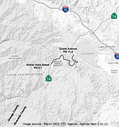 The 2020 SHOPP, approved in May 2020, included the
following Collision Reduction item of interest (carried over from the 2018
SHOPP): 08-Riverside-74 PM 5.7/11.8 PPNO 3016R Proj ID 0819000090 EA
1K690. Route 74 in and near Lake Elsinore, from west of Monte Vista
Street/Vista Road to Grand Avenue. Widen roadway to provide a two-foot
median buffer and four-foot shoulders, install rumble strips, upgrade
guardrail, and regrade side slopes. Programmed in FY23-24, with
construction scheduled to start in December 2024. Total project cost is
$115,474K, with $95,261K being capital (const and right of way) and
$20,213K being support (engineering, environmental, etc.).
The 2020 SHOPP, approved in May 2020, included the
following Collision Reduction item of interest (carried over from the 2018
SHOPP): 08-Riverside-74 PM 5.7/11.8 PPNO 3016R Proj ID 0819000090 EA
1K690. Route 74 in and near Lake Elsinore, from west of Monte Vista
Street/Vista Road to Grand Avenue. Widen roadway to provide a two-foot
median buffer and four-foot shoulders, install rumble strips, upgrade
guardrail, and regrade side slopes. Programmed in FY23-24, with
construction scheduled to start in December 2024. Total project cost is
$115,474K, with $95,261K being capital (const and right of way) and
$20,213K being support (engineering, environmental, etc.).
(Source: 2020 Approved SHOPP a/o May 2020)
In March 2023, the CTC approved for future
consideration of funding the following project for which a MND has been
completed: Route 74 in Riverside County. Provide two-foot-wide median
buffer and four-foot-wide outside shoulders including median and shoulder
rumble strips on the two-lane conventional highway, in Riverside County.
(08-Riv-74, PM 5.7/11.8, PPNO 3016R) The project is located on Route 74
from postmile 5.7 to 11.8, in Riverside County. The Department proposes to
provide a two-foot-wide median buffer and a four-foot-wide outside
shoulders, including median and shoulder rumble strips on the two-lane
conventional highway. The project is fully funded and currently programmed
in the 2022 SHOPP for a total of $115,474,000 which includes Right of Way
(support and capital) and Construction (support and capital). Construction
is estimated to begin 2024-25. The scope, as described for the preferred
alternative, is consistent with the project scope as programmed by the
Commission in the 2022 SHOPP.
(Source: March 2023 CTC Agenda, Agenda Item 2.2c.(1))
In June 2023, the CTC amended the following project in
the 2022 SHOPP: 08-Riv-74 5.7/11.8. PPNO 08-3016R; ProjID 0819000090; EA
1K690. In and near Lake Elsinore, from west of Monte Vista Street/Vista
Road to Grand Avenue. Widen roadway. to provide a two-foot median buffer
and four-foot shoulders, install rumble strips, upgrade guardrail, and
re-grade side slopes. Note: Increase R/W capital because of added costs
for acquisitions and utility relocation needs. Decrease construction
capital as a result of adjusted unit costs. Revise performance to correct
a clerical error. Allocation Changes ($ × 1,000): R/W Cap $3,287
$4,216; Const Cap $91,974 $90,796;
Total $115,474 $115,225.
(Source: June 2023 CTC Agenda, Agenda Item 2.1a.(1d) #64)
Leach Canyon Bridge Reconstruction (RIV 13.2)
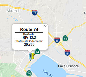 In October 2018, it was reported that the CTC authorized funding (as part of a larger package
of bridge funding) to upgrade Bridge 56-0750 (RIV 13.23, built in 1977) at
Leach Canyon. This work is set to begin in January 2021
In October 2018, it was reported that the CTC authorized funding (as part of a larger package
of bridge funding) to upgrade Bridge 56-0750 (RIV 13.23, built in 1977) at
Leach Canyon. This work is set to begin in January 2021
(Source: Press Enterprise, 10/25/2018)
In May 2020, the CTC approved for future consideration
of funding the Bridge Replacement and Bridge Rail Upgrade project
(08-Riv-74, PM 13.2, 33.9; 08-Riv-79, PM 9.3; 08-Riv-371, PM 65.4), which
will replace one bridge and make improvements to other bridges in
Riverside County. (PPNO 3002C). The project is located in the City of Lake
Elsinore on Route 74, among other locations, in Riverside County. The
Department plans to widen Leach Canyon Bridge on Route 74 to provide
standard shoulder width and upgrade the bridge rail, as well as make
improvements to other bridges. The purpose of the project is to improve
the safety of the traveling public by upgrading bridge rails to meet
current crash and safety standards. This project is fully funded and
currently programmed in the 2018 SHOPP for a total of $12,880,000 which
includes Construction (capital and support) and Right of Way (capital and
support). The total estimated project cost is $14 million. Construction is
estimated to begin fiscal year 2020-2021. The scope, as described for the
preferred alternative, is consistent with the project scope programmed by
the Commission in the 2018 SHOPP.
(Source: May 2020 CTC Agenda, Agenda Item 2.2c.(1))
In August 2020, the CTC approved the following
financial allocation for construction and construction support:
$9,969,000. 08-Riv-74 PM 13.2/34.0. Route 74 In and near the cities of
Lake Elsinore, Perris, Menifee and Hemet, at Leach Canyon Channel Bridge
No. 56-0750 and Blue Ridge Wash Bridge No. 56-0257; also on Route 79 and
Route 371, at Arroyo Seco Bridge No. 56-0189, and Cahuilla Bridge No.
56-0490. Outcome/Output: Upgrade bridge rail on three bridges, replace one
bridge, and extend one culvert. This project will upgrade bridges to meet
current crash and safety standards.
(Source: August 2020 CTC Agenda, Agenda Item
2.5b.(1) #39)
In March 2021, it was reported that construction was
beginning on the Leach Canyon Channel Bridge on Route 74 and Cahuilla
Creek Bridge on Route 371. The $13 million expansions, which are being
handled by Irvine-based Ortiz Enterprises Inc., are scheduled to start on
March 15, 2021. Traffic lights will be installed at the Leach Canyon
Bridge, on the north side of Lake Elsinore at Route 74 and Lincoln Street,
as part of the initial stage of the project. Additionally, traffic signals
are also due for installation in preparation for widening of the Cahuilla
Creek Bridge along Route 371, near Cahuilla Road, just north of the
Cahuilla Indian Reservation. Both expansion projects are slated for
completion in early 2024.
(Source: Lake Elsinore Patch, 3/5/2021)
Relinquishment to Lake Elsinore (08-Riv-74 PM 17.35/19.62)
There are plans to relinquish this route in Lake Elsinore and Perris to give the city more control over the roadway. In June 2008, the state Senate Transportation and Housing Committee unanimously approved AB 1915, a bill sponsored by Assemblyman Kevin Jeffries, R-Lake Elsinore. The vote sends the relinquishment bill to the Senate Appropriations Committee, after which it will be voted on by the full Senate and then Gov. Schwarzenegger. Lake Elsinore has sought to control a portion of Route 74 from just east of I-15 to Grand Avenue since 2006, after Caltrans denied the city's request to put a traffic signal at a corner where a 9-year-old girl died in 2004. By acquiring the roadway, which runs along portions of Central Avenue, Collier Avenue and Riverside Drive, the city would be able to complete about $8 million in road improvements. Perris wants to control a portion of the highway between Redlands Avenue and Seventh Street to make similar improvements. (source)
In January 2017, it was reported that Lake Elsinore has
been trying to pry the highway from state hands for years. Though
legislation in 2008 set the stage for negotiations, the two agencies
couldn’t agree on what the state should pay the city for maintenance
and liability. In 2015, state Assemblywoman Melissa Melendez, a former
Lake Elsinore city councilwoman, authored AB 218. It authorized the state
to negotiate with the county for the relinquishment of the section between
Perris and Lake Elsinore. The bill passed and was signed by Gov. Jerry
Brown. The Caltrans and county discussions gave impetus for reopening
talks with Lake Elsinore over the segment running east from I-15. Caltrans
has agreed to provide the county $5.8 million and Lake Elsinore $2.2
million for the takeovers. The City Council was scheduled to approve the
agreement Tuesday, Jan. 10, 2017, but postponed it until Jan. 24 —
which is when county supervisors are expected to act on their pact. Lake
Elsinore City Manager Grant Yates said state officials requested the delay
to make some minor modifications to the agreement, but it should not stop
it from reaching by the transportation commission. Local control will
enable the city to do its own street improvements, maintenance and
development reviews without Caltrans involvement.
(Source: Press Enterprise, 1/12/2017)
In March 2017, the CTC authorized relinquishment of right of way in the city of Lake Elsinore on Route 74 from Dexter Avenue to the easterly city limits (08-Riv-74 PM 17.35/19.62), under terms and conditions as stated in the relinquishment agreement dated February 13, 2017, determined to be in the best interest of the State. Authorized by Chapter 635, Statutes of 2008, which amended Section 374 of the Streets and Highways Code. The SHOPP amendments showed that the cost of relinquishment was $2.2M for the portion in Lake Elsinore.
In 2005, about 8,900 cars a day used the route, with traffic expected to swell to 28,700 cars a day by 2025, according to Caltrans.
 Double Fine Zones
Between Route 5 and the Riverside-Orange County Line. Authorized by Senate Bill 155, Chapter 169, on July 23, 1999.
 Naming
This segment has been historically named the "Ortega Highway".
The segment is also named the "California Wildland Firefighters Memorial Highway". On August 8, 1959, the Decker Canyon fire was ignited on when a car drove off a Route 74 embankment, crashing through brush to the canyon floor, some 200 feet below. The vehicle burst into flames, and winds whipped the flames into a firestorm racing uphill toward firefighters battling the blaze from above. Six firefighters made the ultimate sacrifice while protecting and serving the people of California by battling the Decker Canyon fire; twenty-seven other firefighters were injured in the fire. California experiences hundreds of wildland fires every year, and thousands of firefighters from local, state, and federal agencies fight these fires to protect lives and property. These men and women of the wildland firefighting services are dedicated in their efforts to save lives and property from destruction, and nearly every year wildland firefighters are injured and killed fighting wildland fires across the State of California. Named by Senate Concurrent Resolution 71, Chapter 22, Chaptered March 26, 2002.
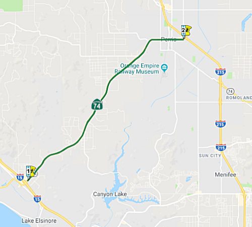 (a) (2) From Route 15 near Lake Elsinore to Route 215 near Perris.
(c) (1) The commission may relinquish to the City of Lake Elsinore the portion of Route 74 located within the city limits of that city, upon terms and conditions the commission finds to be in the best interests of the state. (2) Any relinquishment agreement shall require that the City of Lake Elsinore administer the operation and maintenance of the highway in a manner consistent with professional traffic engineering standards. (3) Any relinquishment agreement shall require the City of Lake Elsinore to ensure that appropriate traffic studies or analyses will be performed to substantiate any decisions affecting the highway. (4) Any relinquishment agreement shall also require the City of Lake Elsinore to provide for public notice and the consideration of public input on the proximate effects of any proposed decision on traffic flow, residences, or businesses, other than a decision on routine maintenance. (5) Notwithstanding any of its other terms, any relinquishmen agreement shall require the City of Lake Elsinore to indemnify and hold the department harmless from any liability for any claims made or damages suffered by any person, including a public entity, as a result of any decision made or action taken by the City of Lake Elsinore, its officers, employees, contractors, or agents, with respect to the design, maintenance, construction, or operation of that portion of Route 74 that is to be relinquished to the city. (6) A relinquishment under this subdivision shall become effective immediately after the county recorder records the relinquishment resolution that contains the commission's approval of the terms and conditions of the relinquishment. (7) On and after the effective date of the relinquishment, both of the following shall occur: (A) The portion of Route 74 relinquished shall cease to be a state highway. (B) The portion of Route 74 relinquished may not be considered for future adoption under Section 81. (8) The City of Lake Elsinore shall ensure the continuity of traffic flow on the relinquished portion of Route 74, including any traffic signal progression. (9) For relinquished portions of Route 74, the City of Lake Elsinore shall maintain signs directing motorists to the continuation of Route 74.
(e) (1) Notwithstanding subdivision (a), the commission may relinquish to the County of Riverside the portion of Route 74 that is located within the unincorporated area east of the City of Lake Elsinore and west of the City of Perris, upon terms and conditions the commission finds to be in the best interests of the state, if the department and the County of Riverside enter into an agreement providing for that relinquishment. (2) A relinquishment under this subdivision shall become effective immediately after the county recorder records the relinquishment resolution that contains the commission’s approval of the terms and conditions of the relinquishment. (3) On and after the effective date of the relinquishment, both of the following shall occur: (A) The portion of Route 74 relinquished under this subdivision shall cease to be a state highway. (B) The portion of Route 74 relinquished under this subdivision may not be considered for future adoption under Section 81. (4) For portions of Route 74 relinquished under this subdivision, the County of Riverside shall maintain signs directing motorists to the continuation of Route 74.
Post 1964 Signage HistoryIn 1963, this segment was defined as “Route 71 to Route 395 near Perris”
In 1969, Chapter 294 changed "Route 395" to "Route 15", reflecting the renumbering of US 395 as I-15.
In 1976, Chapter 1354, changed "Route 71" to "Route 15", and "Route 15" to "Route 194", reflecting the establishment of the route of the real I-15, and the renumbering of the old I-15 as I-15E (Route 194)
In 1982, Chapter 681 changed "Route 194" to "Route 215", reflecting the approval of former US 395 (a/k/a I-15E, Route 194) as non-chargable I-215.
In 1986, Chapter 928 clarified the origin of the segment to be “Route 15 near Lake Elsinore”.
In 2008, Chapter 635 (AB 1915, 9/30/2008) authorized the relinquishement of the portion within the City of Perris with the usual language:
(1) The commission may relinquish to the City of Perris the portion of Route 74 located within the city limits of that city between Seventh Street and Redlands Avenue, upon terms and conditions the commission finds to be in the best interests of the state.
(2) Any relinquishment agreement shall require that the City of Perris administer the operation and maintenance of the highway in a manner consistent with professional traffic engineering standards.
(3) Any relinquishment agreement shall require the City of Perris to ensure that appropriate traffic studies or analyses will be performed to substantiate any decisions affecting the highway.
(4) Any relinquishment agreement shall also require the City of Perris to provide for public notice and the consideration of public input on the proximate effects of any proposed decision on traffic flow, residences, or businesses, other than a decision on routine maintenance.
(5) Notwithstanding any of its other terms, any relinquishment agreement shall require the City of Perris to indemnify and hold the department harmless from any liability for any claims made or damages suffered by any person, including a public entity, as a result of any decision made or action taken by the City of Perris, its officers, employees, contractors, or agents, with respect to the design, maintenance, construction, or operation of that portion of Route 74 that is to be relinquished to the city.
(6) A relinquishment under this subdivision shall become effective immediately after the county recorder records the relinquishment resolution that contains the commission's approval of the terms and conditions of the relinquishment.
(7) On and after the effective date of the relinquishment, both of the following shall occur: (A) The portion of Route 74 relinquished shall cease to be a state highway. (B) The portion of Route 74 relinquished may not be considered for future adoption under Section 81.
(8) The City of Perris shall ensure the continuity of traffic flow on the relinquished portion of Route 74, including any traffic signal progression.
(9) For relinquished portions of Route 74, the City of Perris shall maintain signs directing motorists to the continuation of Route 74.
The right of way in the city of Perris was relinquished in August 2009.
In 2012, Chapter 769 (AB 2679, 9/29/2012) updated the relinquishment languge to reflect that the portion in Perris had been relinquished (see next segment).
In 2015, Chapter 553 (AB 218, 10/7/2015) authorized relinquishment to the County of Riverside that portion of Route 74 located in the unincorporated area east of the City of Lake Elsinore and west of the City of Perris by adding section (e): "(e) (1) Notwithstanding subdivision (a), the commission may relinquish to the County of Riverside the portion of Route 74 that is located within the unincorporated area east of the City of Lake Elsinore and west of the City of Perris, upon terms and conditions the commission finds to be in the best interests of the state, if the department and the County of Riverside enter into an agreement providing for that relinquishment. (2) A relinquishment under this subdivision shall become effective immediately after the county recorder records the relinquishment resolution that contains the commission’s approval of the terms and conditions of the relinquishment. (3) On and after the effective date of the relinquishment, both of the following shall occur: (A) The portion of Route 74 relinquished under this subdivision shall cease to be a state highway. (B) The portion of Route 74 relinquished under this subdivision may not be considered for future adoption under Section 81. (4) For portions of Route 74 relinquished under this subdivision, the County of Riverside shall maintain signs directing motorists to the continuation of Route 74."
In October 2016, the CTC relinquished right of way in the city of Perris on Route 74 between Seventh Street and Redlands Avenue, under terms and conditions as stated in the relinquishment cooperative agreement dated July 9, 2009, determined to be in the best interest of the State. Authorized by Chapter 635, Statutes of 2008, which amended Section 374 of the Streets and Highways Code. Also relinquishes right of way along Route 215 between San Jacinto Avenue and 4th Street, consisting of collateral facilities. The City, by freeway agreement dated November 13, 1995 agreed to accept title upon relinquishment by the State. The 90-day notice period expired September 7, 2016.
In March 2017, the CTC relinquished the portions of Route 74 in Lake Elsinore and unincorporated Riverside County.
Pre 1964 Signage HistoryIn 1934, Route 74 was signed along the route from Jct. US 101 at San Juan Capistrano to Jct. Route 740 at Perris. Route 740 was later renumbered as an eastern extension of Route 74. This segment was established in 1931 as LRN 78, and was renumbered as part of LRN 64 in 1951 by Chapter 1562. Beginning in 1935, this was also signed as US 395. It appears the US 395 signage started around 1935.
Prior to 1952-1953, Route 74 entered from the W. At "D" Street, US 395 turned to the N and continued N and NW towards Riverside. Route 74 turned down "D" Street to 11th, across 11th to Case, and then down diagonally across Case to Romoland. It retained this routing after completion of the Perris-Temecula Bypass, although US 395 no longer turned onto "D" Street. Instead, US 395 continued along 4th to pick up the new US 395 bypass to the E of "G" Street (near what is now Redlands). By 1967, Route 74 had been rerouted along 4th to the Escondido Freeway, US 395.
StatusRelinquishment between Lake Elsinore and Perris (08-Riv-74 PM 17.72/25.76)
In January 2017, it was reported that all 10 miles of
Route 74 between Interstates 15 and 215 will come under local government
control if a state panel acts on the recommendations of transportation
officials. Perris already possesses the 1½-mile section of the state
highway west of I-215 in that city. The California Transportation
Department is now poised to turn over the 8½-mile stretch between
Perris’ western border and I-15 over to Riverside County and Lake
Elsinore. Ultimately, the decision hinges with the California
Transportation Commission. “This is important to us,” county
Transportation Director Patricia Romo said. “We’re looking at
that (transfer) to have local control. As businesses develop (along that
corridor) it makes more sense, so they don’t have to go to Caltrans
for permits. It just makes it much more business friendly to have to deal
with one government agency rather than two.”
(Source: Press Enterprise, 1/12/2017)
In March 2017, the CTC authorized relinquishment of right of way in the county of Riverside on Route 74 from the Lake Elsinore city limits to the Perris city limits (08-Riv-74 PM 17.72/25.76), under terms and conditions as stated in the relinquishment agreement dated February 13, 2017, determined to be in the best interest of the State. Authorized by Chapter 553, Statutes of 2015, which amended Section 374 of the Streets and Highways Code. The SHOPP amendments showed that the cost of relinquishment was $5.8M for the portion in unincorporated Riverside county between Lake Elsinore and Perris.
Relinquishment in Perris
In August 2009, the CTC approved relinquishment of right of way in the city of Perris on Route 74, under terms and conditions as stated in the relinquishment cooperative agreement dated July 9, 2009, determined to be in the best interest of the State. Authorized by Chapter 635, Statutes of 2008, which amended Section 374 of the Streets and Highways Code.
In October 2016, the CTC authorized relinqishment of right of way in the city of Perris on Route 74 between Seventh Street and Redlands Avenue, under terms and conditions as stated in the relinquishment cooperative agreement dated July 9, 2009, determined to be in the best interest of the State. Authorized by Chapter 635, Statutes of 2008, which amended Section 374 of the Streets and Highways Code. Also relinquishes right of way along Route 215 between San Jacinto Avenue and 4th Street, consisting of collateral facilities. The City, by freeway agreement dated November 13, 1995 agreed to accept title upon relinquishment by the State. The 90-day notice period expired September 7, 2016.
Route 74/Route 215 Interchange
The SAFETEA-LU act, enacted in August 2005 as the reauthorization of TEA-21, provided the following expenditures on or near this route:
There are plans to improve the interchange of Route 74 and I-215 in Perris. In August 2009, it was reported that the non-shovel-ready status of a project to revamp Van Buren Boulevard's connection with Route 91 in Riverside meant that the $16 million in federal ARRA funds of that project could be reallocated to the next regional priority: the crossing of westbound Route 74 and I-215. The almost $40 million project at westbound Route 74 would also widen a freeway overcrossing to four lanes instead of two, as well as widen freeway on- and off-ramps.
Double Fine ZonesBetween Route 15 and 7th Street in Perris. Authorized by Senate Bill 1526, Chapter 446, September 14, 2000.
 Other WWW Links
While in Perris, you really should visit the Orange Empire Railway Museum, (now the Southern California Railroad Museum) on "A" Street. It is the west's largest operating railroad museum; you can see the trollycars that use to run in Los Angeles.
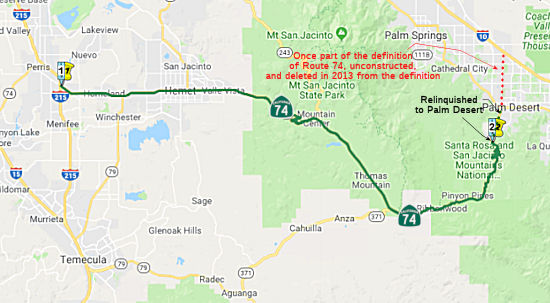 (a) (3)
From Route 215 near Perris to the southern city limit of Palm Desert.
(a) (3)
From Route 215 near Perris to the southern city limit of Palm Desert.
(b) The relinquished former portions of Route 74 within the City of Palm Desert and Perris are not state highways and are not eligible for adoption under Section 81. For the relinquished former portions of Route 74, the City of Palm Desert and Perris shall maintain within its jurisdiction signs directing motorists to the continuation of Route 74 and shall ensure the continuity of traffic flow on the relinquished portions of Route 74, including any traffic signal progression.
(d) (1) Notwithstanding subdivision (a), the commission may relinquish to the City of Hemet the portion of Route 74 that is located within the city limits of the City of Hemet, upon terms and conditions the commission finds to be in the best interests of the state, if the department and the City of Hemet enter into an agreement providing for that relinquishment. (2) A relinquishment under this subdivision shall become effective immediately following the recordation by the county recorder of the relinquishment resolution containing the commission’s approval of the terms and conditions of the relinquishment. (3) On and after the effective date of the relinquishment, both of the following shall occur: (A) The portion of Route 74 relinquished under this subdivision shall cease to be a state highway. (B) The portion of Route 74 relinquished under this subdivision may not be considered for future adoption under Section 81. (4) The City of Hemet shall ensure the continuity of traffic flow on the portion of Route 74 relinquished under this subdivision, including any traffic signal progression. (5) For portions of Route 74 relinquished under this subdivision, the City of Hemet shall maintain signs directing motorists to the continuation of Route 74.
Post 1964 Signage HistoryAs defined in 1963, this segment ran from “Route 395 near Perris to Route 111.”
 In 1965, Chapter 1372 extended this segment to terminate at “Route 10 near Indio.” Note that the portion from Route 111 to
Route 10 remains unconstructed.
In 1965, Chapter 1372 extended this segment to terminate at “Route 10 near Indio.” Note that the portion from Route 111 to
Route 10 remains unconstructed.
In 1969, Chapter 294 changed "Route 395" to "Route 15", reflecting the renumbering of US 395 as I-15.
In 1976, Chapter 1354 changed "Route 15" to "Route 194", reflecting the establishment of the route of the real I-15, and the renumbering of the old I-15 as I-15E (Route 194)
In 1982, Chapter 681 changed "Route 194" to "Route 215", reflecting the approval of former US 395 (a/k/a I-15E, Route 194) as non-chargable I-215.
In 1986, Chapter 928 clarified the terminus of the segment to be “Route 10 near Thousand Palms via Hemet and Palm Desert”. Under this current routing, Monterey Avenue may be Route 74 between Route 111 and I-10.
In 2005, Chapter 594 authorized relinquishment of the portion in Palm Desert. This segment was relinquished in February 2008:
The commission may relinquish to the City of Palm Desert the portion of Route 74 that is located within the city limits of that city, upon terms and conditions the commission finds to be in the best interests of the state, if the department and the city enter into an agreement providing for that relinquishment. A relinquishment under this subdivision shall become effective immediately following the county recorder's recordation of the relinquishment resolution containing the commission's approval of the terms and conditions of the relinquishment. On and after the effective date of the relinquishment, the relinquished portion of Route 74 shall cease to be a state highway. The portion of Route 74 relinquished under this subdivision shall be ineligible for future adoption under Section 81. For the portion of Route 74 that is relinquished under this subdivision, the City of Palm Desert shall maintain within its jurisdiction signs directing motorists to the continuation of Route 74. [SB 186, 10/6/2005, Chapter 594]. The Palm Desert segment was relinquished in February 2008.
In 2010, Chapter 421 (SB 1318, 9/29/10) changed the terminus of this
segment as follows: "to Route 10 near Thousand Palms via Hemet and
Palm Desert the southern city limit of Palm Desert.,
and added a new segment on the other side of Palm Desert.
In 2013, Chapter 525 (SB 788, 10/9/13) added words to the relinquishment text:
"(b) The relinquished former portions of Route 74 within the Cities of Palm Desert and Perris are not state highways and are not eligible for adoption under Section 81. For the former portions of Route 74 relinquished under this subdivision, the Cities of Palm Desert and Perris shall maintain within their respective jurisdictions signs directing motorists to the continuation of Route 74 and shall ensure the continuity of traffic flow on the relinquished portions of Route 74, including any traffic signal progression."
Chapter 525 also added segment (d): "(d) (1) Notwithstanding subdivision (a), the commission may relinquish to the City of Hemet the portion of Route 74 that is located within the city limits of the City of Hemet, upon terms and conditions the commission finds to be in the best interests of the state, if the department and the City of Hemet enter into an agreement providing for that relinquishment. (2) A relinquishment under this subdivision shall become effective immediately following the recordation by the county recorder of the relinquishment resolution containing the commission’s approval of the terms and conditions of the relinquishment. (3) On and after the effective date of the relinquishment, both of the following shall occur: (A) The portion of Route 74 relinquished under this subdivision shall cease to be a state highway. (B) The portion of Route 74 relinquished under this subdivision may not be considered for future adoption under Section 81. (4) The City of Hemet shall ensure the continuity of traffic flow on the portion of Route 74 relinquished under this subdivision, including any traffic signal progression. (5) For portions of Route 74 relinquished under this subdivision, the City of Hemet shall maintain signs directing motorists to the continuation of Route 74. "
Chapter 525 also deleted segment (4): "Route 111 in Palm Desert to Route 10 near Thousand Palms.", which had been created in 2010 as a split from segment (3) by Chapter 421, 9/29/10, SB 1318. Monterey Avenue provided a route between (former) Route 111 and I-10, but most of the route was annexed by the Cities of Rancho Mirage and Palm Desert. Rancho Mirage was not in favor of adoption of this route as a state highway. Further complicating matters was the 4-lane bridge over the Whitewater River along Monterey Avenue.
Pre 1964 Signage HistoryThis segment was originally signed as Sign Route 740 in the initial state signage of routes in 1934. It ran from US 395 in Perris to US 60/US 70/US 99 in Indio/Coachella. It was cosigned with Sign Route 111 between Palm Springs and Coachella. Sign Route 740 was changed by 1935 to Sign Route 74. It was LRN 64, and was defined in 1933.
Route 74 originally entered from the W along Fourth, turned S on D Street to Eleventh, across Eleventh to Case, and then SE along Case into Romoland. By 1967, Route 74 had been routed to continue along Fourth to the Escondido Freeway, US 395/I-15E, which it then followed down to Case/Monitor to pick up the Route 74 routing into Hemet.
This segment is traditionally known as the Palms-to-Pines Highway. What
became the Pines to Palms Highway was constructed in a joint project by
Riverside County and the National Forest Service in the 1920s. The Pines
to Palms Highway was officially designated by Riverside County in 1930.
The Pines to Palms Highway opening ceremony was held on June 18th 1932
according to a July 1932 Department of Public Works Publication. On a 1934
Department of Public Works Guide Route 74 was announced as a highway
running from US 101 near San Juan Capistrano east on the Ortega Highway to
Route 740 in Perris. Route 740 was added as a Signed State Route from US 60 in Riverside east to Route 111 in Coachella Valley. US 395 was
officially extended into California during a June 1934 AASHTO meeting. US 395 annexed what was to have been Route 740 on LRN 78 between Riverside
and Perris. It also multiplexed Route 74 west of Perris before turning
south towards Temecula on what previously had been Route 71. Route 740
east of Perris wasn't immediately consolidated into Route 74 as it appears
east of Route 74/US 395 on a 1935 Goshua Highway Map of California. Route 740 east of Perris was annexed into Route 74 no later than 1935, as Route 74 appears as a singular route between San Juan Capistrano and Coachella
Valley on the May 1935 Division of Highways State Map.
(Source: Gribblenation Blog "California State Route 74; the Pines to Palms Highway", a/o 11/23/2019)
Status The 2013 Traversable Highways report notes this is unconstructed from the former Route 111 to I-10. The Local Arterial,
Monterey Avenue, provides a connection to Route 10. Monterey Avenue is
almost entirely within the City Limits of Rancho Mirage and Palm Desert
south of Route 10. Improvements to the Monterey Avenue Interchange at I-10
are planned to be completed in 2014. Also, a 4-lane bridge now exists on
Monterey Avenue over the Whitewater River. No local roads adequately fit
the description of a traverasable highway.
Plans are underway for a major rerouting of a segment of Route 74 (or perhaps a new segment) to improve regional transportation between Corona and San Jacinto. Information can be found at http://www.rctc.org/, which is the agenda for the Riverside County Transportation Commission. More information can also be found at the Riverside County Improvement Project pages, www.rcip.org.
In short, the Route 74 Realignment project is a Measure "A" project from Dexter Avenue in the City of Lake Elsinore to 7th Street in the City of Perris. The project will be constructed in two segments. Segment 1 is from Dexter Avenue in Lake Elsinore to approximately 1640 feet east of Wasson Canyon Road. Segment 2 is from approximately 1640 feet east of Wasson Canyon Road to 7th Street in Perris.
According to a recent article in the Los Angeles Times, this proposal may have been the subject of some rerouting. Although Route 74 was not mentioned by number, the article discussed how the push for a new thoroughfare between Corona and Hemet has created trouble in Lake Elsinore, where there was an earlier proposal (i.e., the Route 74 propsoal) which would make the Lake Elsinore the western terminus of the route. Evidently, the RTCT originally supported a route north of Lake Mathews, but that ran into pricy homes and strong opposition from residents. The alternative would send the 40-mile, $700-million road south of the lake, through an endangered-species reserve, which naturally creates problems for environmentalists. The route now favored would expand the existing two-lane Cajalco Road through the nature preserve south of the lake. However, in Lake Elsinore, they are upset because the originally plan was a 22-mile route that would connect I-15 near Lake Elsinore to Route 79 near Diamond Valley Lake. However, because of the possibility of someday linking the route near Lake Mathews to a new thoroughfare running into Orange County, support for the Lake Elsinore-Diamond Valley Lake roadway declined.
 One alternative is the Mid-County Parkway. In October 2008, a Draft Environmental Impact Report/Environmental Impact Statement (Draft EIR/EIS) was released
evaluating the alternatives for the Mid County Parkway, a proposed 32-mile
corridor designed to stretch from San Jacinto through Perris to Corona to
meet regional transportation needs through 2035. The Draft EIR/EIS
compiled environmental studies analyzing the effects of the alternatives
on the human and natural environment. Public information open houses and
public hearings were held in October and November 2008 to collect comments
on the Draft EIR/EIS. Comments submitted on the Draft EIR/EIS raised
environmental and community concerns regarding the portion of the project
between I-15 and I-215 and funding concerns about the entire project. In
the short term, the County of Riverside is proceeding with its plans to
improve Cajalco Road. The Riverside County General Plan Circulation
Element designates Cajalco Road from I-15 to I-215 as a four to six-lane
major roadway. The Mid-County Parkway was refocused on the Eastern
segment. The modified project does not eliminate the need for a future
route that will one day connect I-15 to I-215, as identified as a part of
the Community Environmental Transportation Acceptability Process (CETAP).
RCTC is maintaining that long term vision but RCTC is focusing its near
term project approval efforts on the vitally needed eastern 16 miles
between I-215 and Route 79.
One alternative is the Mid-County Parkway. In October 2008, a Draft Environmental Impact Report/Environmental Impact Statement (Draft EIR/EIS) was released
evaluating the alternatives for the Mid County Parkway, a proposed 32-mile
corridor designed to stretch from San Jacinto through Perris to Corona to
meet regional transportation needs through 2035. The Draft EIR/EIS
compiled environmental studies analyzing the effects of the alternatives
on the human and natural environment. Public information open houses and
public hearings were held in October and November 2008 to collect comments
on the Draft EIR/EIS. Comments submitted on the Draft EIR/EIS raised
environmental and community concerns regarding the portion of the project
between I-15 and I-215 and funding concerns about the entire project. In
the short term, the County of Riverside is proceeding with its plans to
improve Cajalco Road. The Riverside County General Plan Circulation
Element designates Cajalco Road from I-15 to I-215 as a four to six-lane
major roadway. The Mid-County Parkway was refocused on the Eastern
segment. The modified project does not eliminate the need for a future
route that will one day connect I-15 to I-215, as identified as a part of
the Community Environmental Transportation Acceptability Process (CETAP).
RCTC is maintaining that long term vision but RCTC is focusing its near
term project approval efforts on the vitally needed eastern 16 miles
between I-215 and Route 79.
 With respect to the Eastern Segment: An option favored by
the city to build a stretch of the proposed Mid County Parkway next to
Perris Dam is considered to be is unsafe because of seismic dangers.
Officials hope the future freeway will help relieve east-west traffic
congestion in the rapidly growing corridor between San Jacinto and Corona.
The project is expected to cost $2 billion and would extend 32 miles from
Corona to San Jacinto. The six- to eight-lane parkway would serve as an
alternate east-west freeway to Route 60 and Route 91. Construction is
scheduled to start in 2011. State officials say routing the parkway via
the dam ("North Perris Option") is out of the question, because of the
risk of earthquakes and liquefaction of soils beneath the dam's eastern
foundation. The RCTC would like the City of Perris to instead pick one of
three remaining parkway routing options: via Placentia Avenue, via Rider
Street, or via the city's storm drain canal. The storm drain route,
however, would be the most expensive of the four options, for the drain
passes through an area of town prone to flooding and the parkway would
thus have to be elevated there to protect motorists from rising waters.
The problem with the Rider Street option is it could require the
construction of a road connecting Rider to Cajalco Road or Placentia
Avenue on the west side of I-215 -- depending on if the parkway goes up
along Cajalco or Placentia. The fourth option of routing the parkway
through Perris along Placentia Avenue east of I-215 would be the cheapest
and straightest through the city, but would require moving a state-of-art
fire station out of the way, which city officials only dedicated in early
2007.
With respect to the Eastern Segment: An option favored by
the city to build a stretch of the proposed Mid County Parkway next to
Perris Dam is considered to be is unsafe because of seismic dangers.
Officials hope the future freeway will help relieve east-west traffic
congestion in the rapidly growing corridor between San Jacinto and Corona.
The project is expected to cost $2 billion and would extend 32 miles from
Corona to San Jacinto. The six- to eight-lane parkway would serve as an
alternate east-west freeway to Route 60 and Route 91. Construction is
scheduled to start in 2011. State officials say routing the parkway via
the dam ("North Perris Option") is out of the question, because of the
risk of earthquakes and liquefaction of soils beneath the dam's eastern
foundation. The RCTC would like the City of Perris to instead pick one of
three remaining parkway routing options: via Placentia Avenue, via Rider
Street, or via the city's storm drain canal. The storm drain route,
however, would be the most expensive of the four options, for the drain
passes through an area of town prone to flooding and the parkway would
thus have to be elevated there to protect motorists from rising waters.
The problem with the Rider Street option is it could require the
construction of a road connecting Rider to Cajalco Road or Placentia
Avenue on the west side of I-215 -- depending on if the parkway goes up
along Cajalco or Placentia. The fourth option of routing the parkway
through Perris along Placentia Avenue east of I-215 would be the cheapest
and straightest through the city, but would require moving a state-of-art
fire station out of the way, which city officials only dedicated in early
2007.
In October 2009, it was reported that comments on the draft EIR had led RCTC to focus the project so the RCTC can make the best use of limited transportation dollars while addressing the most immediate traffic needs. The Mid County Parkway project is now a proposed 16-mile transportation corridor to relieve local and regional traffic congestion in the San Jacinto and Perris areas and surrounding Riverside County communities. Focusing on the eastern stretch of the Mid County Parkway between I-215 and Route 79 will allow RCTC to make the best use of limited transportation dollars while providing immediate traffic and safety benefits where they are needed most. Modifying this project will allow RCTC to move more quickly to provide improvements where the need is greatest and avoid time-consuming delays tied to environmental constraints and community challenges affecting the portion of the original project proposed between I-15 and I-215.
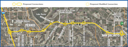 In March 2014, the CTC received notice of the circulation of an EIR regarding the Mid-County
Parkway. It noted that the proposed project is located in western
Riverside County and will construct a 16 mile transportation corridor
between Interstate-215 (I-215) and Route 79 connecting the Cities of San
Jacinto and Perris with a divided highway including on and off ramps and
interchanges at I-215 and Route 79. The alternatives evaluated in the
RDEIR/RDEIS include three Build Alternatives and two No-Build
Alternatives. Riverside County has a project in the words to construct a
16 mile west-east transportation corridor between I-215 and Route 79
connecting the Cities of San Jacinto and Perris. The project will consist
of a divided highway including three lanes in each direction with on and
off ramps as well as freeway-freeway type interchanges at I-215 and Route 79. This project is currently at the EIR stage.
In March 2014, the CTC received notice of the circulation of an EIR regarding the Mid-County
Parkway. It noted that the proposed project is located in western
Riverside County and will construct a 16 mile transportation corridor
between Interstate-215 (I-215) and Route 79 connecting the Cities of San
Jacinto and Perris with a divided highway including on and off ramps and
interchanges at I-215 and Route 79. The alternatives evaluated in the
RDEIR/RDEIS include three Build Alternatives and two No-Build
Alternatives. Riverside County has a project in the words to construct a
16 mile west-east transportation corridor between I-215 and Route 79
connecting the Cities of San Jacinto and Perris. The project will consist
of a divided highway including three lanes in each direction with on and
off ramps as well as freeway-freeway type interchanges at I-215 and Route 79. This project is currently at the EIR stage.
In October 2017, it was reported that another appeal has been filed
against the Mid County Parkway, a proposed 16-mile east-west highway
corridor that would link Perris and San Jacinto between I-215 Freeway and
Route 79. On Tuesday, Oct. 10, conservation groups filed an appeal in
state court challenging the $2 billion project, claiming it would cut
through low-income neighborhoods, threaten wildlife preserves and worsen
air pollution. In separate cases, both federal and superior court judges
upheld the project, saying it meets environmental requirements. The appeal
was filed with the 4th District Court of Appeal in Riverside by the Center
for Biological Diversity, Sierra Club, San Bernardino Valley Audubon
Society and Friends of the Northern San Jacinto Valley against the
Riverside County Transportation Commission, which is overseeing the
project. They claim the six-lane road would fragment the San Jacinto
Valley, opening the door to sprawl and traffic in a rural area. The road
would be an alternative to the Ramona Expressway, which currently links
San Jacinto and Perris. The Mid County Parkway proposal dates to 1999 and
initially was to reach 32 miles from San Jacinto to I-15 in Corona. It was
cut in half in 2009 after it faced a steep price tag and stiff opposition
from residents west of I-215. The project would be paid for partially
through Measure A, a half-cent sales tax approved by Riverside County
voters.
(Source: Press-Enterprise, 10/11/2017)
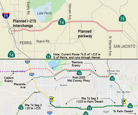 In October 2018, it was reported that $65 million in
funding (including $7.1MM in SB1 funds) was finally in place for the first
interchange of the Mid-County Parkway (potential future realignment of
Route 74). As planned, it will start at an interchange on I-215 at
Placentia Avenue and stretch eastward, eventually taking over the
thoroughfare currently traversed by the Ramona Expressway. The plan is to
add an entrance and exit to I-215, improve a frontage road, widen the
existing Placentia Avenue bridge and widen Placentia between Harvill and
Indian avenues, a news release states. It will provide an alternative to
Route 60 to the north and Route 74 to the south. As of October 2018,
however, only a small portion of the approximately $1 billion project is
funded: the interchange on I-215 near Placentia Avenue. When completed,
the freeway will be a designated state route with three lanes in either
direction. A handful of homes north of Paragon Park in Perris will have to
be demolished to make way for the new freeway. But that's several years
away and that part of the project isn't even funded yet. The interchange
is scheduled to begin construction in 2020. The remainder of the freeway
will begin construction afterward, depending on the availability of
funding. The Parkway came out of the Riverside County Integrated Project,
a three-pronged planning effort launched around the turn of the century to
identify new highway corridors, design a habitat preservation plan and
update the county’s blueprint for growth. Originally, the freeway
was to run 32 miles from I-15 in Corona to Route 79 in San Jacinto. In
2009, the county transportation commission scrapped the western half
between I-15 and I-215 amid escalating costs and concerns about
environmental constraints in the Lake Mathews area and Gavilan Hills. The
original concept was to run it down Route 74, but the Perris City Council
fiercely opposed that route because downtown Perris was in the path. For
the western section, the county plans to widen Cajalco Road to four lanes
between I-15 and I-215.
In October 2018, it was reported that $65 million in
funding (including $7.1MM in SB1 funds) was finally in place for the first
interchange of the Mid-County Parkway (potential future realignment of
Route 74). As planned, it will start at an interchange on I-215 at
Placentia Avenue and stretch eastward, eventually taking over the
thoroughfare currently traversed by the Ramona Expressway. The plan is to
add an entrance and exit to I-215, improve a frontage road, widen the
existing Placentia Avenue bridge and widen Placentia between Harvill and
Indian avenues, a news release states. It will provide an alternative to
Route 60 to the north and Route 74 to the south. As of October 2018,
however, only a small portion of the approximately $1 billion project is
funded: the interchange on I-215 near Placentia Avenue. When completed,
the freeway will be a designated state route with three lanes in either
direction. A handful of homes north of Paragon Park in Perris will have to
be demolished to make way for the new freeway. But that's several years
away and that part of the project isn't even funded yet. The interchange
is scheduled to begin construction in 2020. The remainder of the freeway
will begin construction afterward, depending on the availability of
funding. The Parkway came out of the Riverside County Integrated Project,
a three-pronged planning effort launched around the turn of the century to
identify new highway corridors, design a habitat preservation plan and
update the county’s blueprint for growth. Originally, the freeway
was to run 32 miles from I-15 in Corona to Route 79 in San Jacinto. In
2009, the county transportation commission scrapped the western half
between I-15 and I-215 amid escalating costs and concerns about
environmental constraints in the Lake Mathews area and Gavilan Hills. The
original concept was to run it down Route 74, but the Perris City Council
fiercely opposed that route because downtown Perris was in the path. For
the western section, the county plans to widen Cajalco Road to four lanes
between I-15 and I-215.
(Source: ABC7, 10/24/2018; Press-Enterprise, 10/24/2018)
In June 2019, the CTC approved for future consideration of funding the
Midway Parkway Project. The Project will construct a 16-mile west/east
transportation corridor known as the Midway Parkway between I-215 and
Route 79, including full or partial access control with grade separations
at local intersections, a mix-flow lane to the Van Buren Boulevard
interchange, an additional mix-flow lane from Nuevo Road to the
Cajalco-Ramona Expressway, a new interchange at Placentia Avenue, and
modifications to the existing interchange at the Cajalco Road/Ramona
Expressway. The Project is located in western Riverside County between
I-215 in the west and Route 79 in the east, Riverside County. On April 8,
2015, the Riverside County Transportation Commission adopted the Final
Environmental Impact Report, including the Statement of Overriding
Considerations. The Project is estimated to cost $1,321,042,000 and is
fully funded with Local Measure A Funds ($263,700,000), Riverside County
Bond Funds ($932,000,000), Riverside County Transportation Uniform
Mitigation Fee Funds ($118,300,000), and Local Partnership Program Funds
($7,042,000). Construction is estimated to begin in Fiscal Year 2019-20.
(Source: June 2019 CTC Minutes, Agenda Item
2.2c.(9))
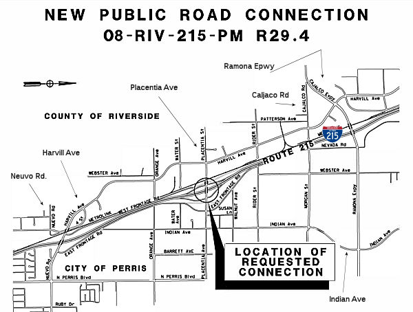 In December 2019, the CTC had on its agenda authorization
of a new public road connection to I-215 at Placentia Avenue, PM R29.4.
The I-215/Placentia Avenue interchange was originally proposed in the
planning stages of the I-215 corridor in the late 1980s, and right-of-way
was purchased for a future interchange when operational needs and local
development justified its construction. A grade-separated overcrossing was
constructed at Placentia Avenue as part of the original I-215 corridor
project. The interchange was also contemplated as part of RCTC's Mid
County Parkway (MCP) project, which began development in 2005. The Project
Study Report for the MCP between I-15 in the city of Corona and Route 79
near San Jacinto was approved on December 29, 2004. In May 2008, the FHWA
sent a letter to Caltrans stating the acceptability with conditional
approval of the original New Connection Report. On February 20, 2013, the
public was informed of the decision to reduce the length of the corridor
to focus improvements where the need was the greatest, between I-215 and
Route 79. FHWA provided the final approval of the New Connection Report
for the change in Interstate access on December 16, 2016. The purpose of
the proposed project is to improve local access to I-21 by adding an
interchange at Placentia Avenue in the City of Perris to serve the growing
cities of Perris, Hemet, San Jacinto, and the adjacenet unincorporated
areas of Riverside County. The proposed improvements include: (1)
construction of a new interchange at Placentia Avenue and I-215 with NB
and SB entrance and exit ramps on the east and west sides of I-215 at
Placentia Avenue; (2) relocation of the East Frontage Road; (3) widening
of the Placentia Avenue bridge from two to six lanes between Harvill
Avenue on the west and Indian Avenue on the east; (4) construction of
drainage improvements; and (5) installation of new traffic signals on
Placentia Ave at Harville Avenue, Indian Avenue, East Frontage Road, and
at the ramp intersections. The current construction funding for the
project is $46,475K, including $6,000K for construction management.
Riverside County Measure A is funding $39,433K, and the SB1 LPP is funding
$7,042K. The funding for the right of way acquisition is $25,900K from
Measure A. The General Plan for the City of Perris includes a future local
service interchange at Placentia Avenue. RCTC has agreed to include the
addition of local access at Placentia Ave as part of the MCP project.
Riverside County is also in favor of the interchange at I-215 and
Placentia Avenue.
In December 2019, the CTC had on its agenda authorization
of a new public road connection to I-215 at Placentia Avenue, PM R29.4.
The I-215/Placentia Avenue interchange was originally proposed in the
planning stages of the I-215 corridor in the late 1980s, and right-of-way
was purchased for a future interchange when operational needs and local
development justified its construction. A grade-separated overcrossing was
constructed at Placentia Avenue as part of the original I-215 corridor
project. The interchange was also contemplated as part of RCTC's Mid
County Parkway (MCP) project, which began development in 2005. The Project
Study Report for the MCP between I-15 in the city of Corona and Route 79
near San Jacinto was approved on December 29, 2004. In May 2008, the FHWA
sent a letter to Caltrans stating the acceptability with conditional
approval of the original New Connection Report. On February 20, 2013, the
public was informed of the decision to reduce the length of the corridor
to focus improvements where the need was the greatest, between I-215 and
Route 79. FHWA provided the final approval of the New Connection Report
for the change in Interstate access on December 16, 2016. The purpose of
the proposed project is to improve local access to I-21 by adding an
interchange at Placentia Avenue in the City of Perris to serve the growing
cities of Perris, Hemet, San Jacinto, and the adjacenet unincorporated
areas of Riverside County. The proposed improvements include: (1)
construction of a new interchange at Placentia Avenue and I-215 with NB
and SB entrance and exit ramps on the east and west sides of I-215 at
Placentia Avenue; (2) relocation of the East Frontage Road; (3) widening
of the Placentia Avenue bridge from two to six lanes between Harvill
Avenue on the west and Indian Avenue on the east; (4) construction of
drainage improvements; and (5) installation of new traffic signals on
Placentia Ave at Harville Avenue, Indian Avenue, East Frontage Road, and
at the ramp intersections. The current construction funding for the
project is $46,475K, including $6,000K for construction management.
Riverside County Measure A is funding $39,433K, and the SB1 LPP is funding
$7,042K. The funding for the right of way acquisition is $25,900K from
Measure A. The General Plan for the City of Perris includes a future local
service interchange at Placentia Avenue. RCTC has agreed to include the
addition of local access at Placentia Ave as part of the MCP project.
Riverside County is also in favor of the interchange at I-215 and
Placentia Avenue.
(Source: December 2019 CTC Agenda, Agenda Item
2.3b)
In March 2020, the CTC approved the following
financial allocation: 08-Riv-215 R27.9/R32.8. I-215/Placentia Avenue
Interchange Project. In the city of Perris, from 0.3 Miles South of Perris
Boulevard Undercrossing to 0.5 Miles North of Oleander Avenue
Overcrossing. Construct a new interchange at Placentia Avenue. Construct
various improvements at existing intersections. Financial allocation:
$7,090,000.
(Source: March 2020 CTC Agenda, Agenda Item
2.5s.(2) #2)
In June 2020, the CTC approved amending the Local Partnership Formulaic
Program – Advance Program of Projects to program $14,160,000 for
Riverside County Transportation Commission to fund construction of the
I-215/Placentia Avenue Interchange project in Fiscal Year 2020-21. The
project will construct a new interchange. The project will improve
connectivity and reduce greenhouse gas emissions.
(Source: June 2020 CTC Agenda, Agenda Item 4.23)
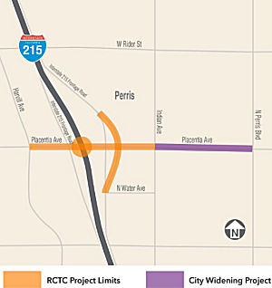 In Summer 2020, work started on Construction Contract #1 for the Mid-County Parkway.
This is the I-215 Placentia Avenue Interchange in Perris; the overall
project will provide a new 16-mile east-west transportation corridor
between San Jacinto and Perris. The new interchange located between Ramona
Expressway to the north and Nuevo Road to the south, is designed to meet
the needs of the area’s growing population. Benefits and features
include new northbound and southbound on-ramps and off-ramps on I-215 at
Placentia Avenue; re-alignment of East Frontage Road, widening the
existing Placentia Avenue overcrossing, and adding lanes to Placentia
Avenue between Harvill Avenue and Indian Avenue. Construction began in
summer 2020 and the new interchange should be open to drivers in summer
2022, weather permitting. An approximate 10-month full closure of the
Placentia Avenue bridge is in place starting July 20, 2021.
In Summer 2020, work started on Construction Contract #1 for the Mid-County Parkway.
This is the I-215 Placentia Avenue Interchange in Perris; the overall
project will provide a new 16-mile east-west transportation corridor
between San Jacinto and Perris. The new interchange located between Ramona
Expressway to the north and Nuevo Road to the south, is designed to meet
the needs of the area’s growing population. Benefits and features
include new northbound and southbound on-ramps and off-ramps on I-215 at
Placentia Avenue; re-alignment of East Frontage Road, widening the
existing Placentia Avenue overcrossing, and adding lanes to Placentia
Avenue between Harvill Avenue and Indian Avenue. Construction began in
summer 2020 and the new interchange should be open to drivers in summer
2022, weather permitting. An approximate 10-month full closure of the
Placentia Avenue bridge is in place starting July 20, 2021.
(Source: RCTC Page on Construction Contract #1)
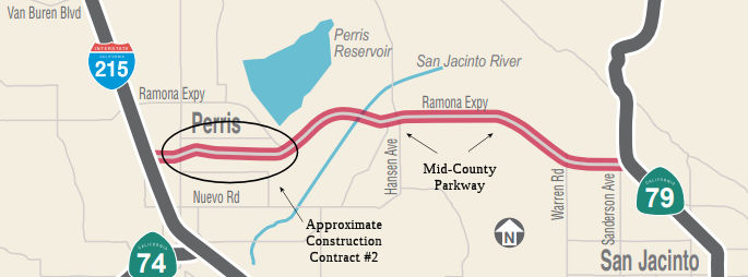 In October 2021, the CTC approved a request from Riverside County
Transportation Commission to add the Mid County Parkway Construction
Contract #2 (Redlands Avenue to Ramona Expressway) Project in Riverside
County and program $5,686,000 of their 2020 Formulaic Program funding for
the Plans, Specifications and Estimate phase in Fiscal Year 2021-22. This
project will include the preparation of the Plans, Specifications and
Estimate phase for an approximately three-mile segment of the planned Mid
County Parkway between Redlands Avenue and Ramona Expressway. The Mid
County Parkway project will construct a new, non-tolled and largely
signal-free, east-west alternate route to and from Interstate 215. The
anticipated benefits of this project include improved access and reduced
travel time.
In October 2021, the CTC approved a request from Riverside County
Transportation Commission to add the Mid County Parkway Construction
Contract #2 (Redlands Avenue to Ramona Expressway) Project in Riverside
County and program $5,686,000 of their 2020 Formulaic Program funding for
the Plans, Specifications and Estimate phase in Fiscal Year 2021-22. This
project will include the preparation of the Plans, Specifications and
Estimate phase for an approximately three-mile segment of the planned Mid
County Parkway between Redlands Avenue and Ramona Expressway. The Mid
County Parkway project will construct a new, non-tolled and largely
signal-free, east-west alternate route to and from Interstate 215. The
anticipated benefits of this project include improved access and reduced
travel time.
(Source: October 2021 CTC Agenda, Agenda Item 4.18)
In January 2022, the CTC approved the following financial allocation:
$5,686,000. Mid-County Parkway (Route 74). PPNO 08-1276; PPNO 0821000011.
Mid County Parkway (MCP) Phase 2. (Note: Discussed with Route 74)
Construct 4 lanes on future MCP alignment between Redlands Ave and future
Antelope Rd. The proposed project will provide several benefits including
access, reduced travel time, and cleaner air. Allocation: PS&E
$5,686,000.
(Source: January 2022 CTC Agenda, Agenda Item
2.5s.(3b))
In 2022, the CTC approved including "Mid County Parkway Construction
Contract 2" in the list of projects for the Coronavirus Response and
Relief Supplemental Appropriations Act of 2021 (CRRSAA). The CRRSAA
Program guidelines require regions submit a project list for allocation by
the Commission prior to the obligation of funds. Under CRRSAA, the funds
may be used for a broad range of surface transportation purposes listed in
Section 113(b) of Title 23 of the U.S. Code and are meant to
“prevent, prepare for, and respond to coronavirus.”
Specifically, CRRSAA allows states to cover revenue losses, which is
important given that California’s State-generated transportation
revenues have declined by about $1.5 billion due to the pandemic.
Additionally, CRRSAA allows the funds to be used for preventive and
routine maintenance; operations; personnel; salaries; contracts; debt
service payments; and availability payments; as well as transfers to
public tolling agencies. At the March 2021 Commission meeting, the CTC
approved the CRRSAA funding distribution and regional apportionments. The
CRRSAA allocation for this project was $6,314,000.
(Source: August 2022 CTC Minutes, Agenda Item 2.5k)
In August 2022, the CTC approved an amendment for the
locally-administered SB 1 LPP (Formulaic) Mid County Parkway (MCP) Phase 2
(PPNO 1276) projects, in Riverside County, to approve a minor scope change
that amends the project title, project description, and outputs. As noted
above, athe January 2022 meeting, the Commission approved Resolution
LPP-A-2122-15 allocating a total of $5,686,000 in SB1 LPP (Formulaic)
funds for the Plans, Specifications, and Estimates (PS&E) phase for
the project. However, after the project was approved, the municipalities
involved in the project could not agree on the proposed scope. As a
result, the scope was changed from “building a new alignment”
to “adding lanes and other improvement to a nearby section of an
existing alignment along the same corridor”. The change was approved
as a minor scope change by Commission staff on July 15, 2022. The change
in the description is as follows: Mid County Parkway (MCP) Phase 2
Contract 3. Construct 4 lanes on future MCP alignment
between Redlands Ave and future Antelope Rd. Construct 2
additional lanes on MCP alignment between west of Pico Avenue to Warren
Road along Ramona Expressway and make safety improvements, including
adding median barriers, a new bridge and several traffic signals.
(Source: August 2022 CTC Agenda, Agenda Item
2.5s.(7))
In May 2025, the CTC amended the Local Partnership Formulaic Program to
add in: Mid County Parkway: Ramona Expressway 2024-2025 CONST $18,775,000.
(Source: May 2025 CTC Agenda, Agenda Item 4.17)
In July 2025, it was reported that the Ramona Expressway portion of this
route would receive $63 million in funding for improvements, such as
providing two lanes in each direction, a new bridge over the San Jacinto
River, bike lanes in each direction, and a new wildlife crossing.
(Source: FB/State Senator Sabrina Cervantes, 7/5/2025)
In December 2025, it was reported that the Riverside County
Transportation Commission approved more than $156 million in construction
contracts for two regionally significant projects during its December 10,
2025 meeting: Mid County Parkway Ramona Expressway and Route 60/Potrero
Boulevard Interchange – Phase II. The Mid County Parkway Ramona
Expressway Project will upgrade 8.6 miles of roadway between Rider Street
and Warren Road in San Jacinto. Between 2017 and 2022, this heavily
traveled corridor experienced numerous collisions resulting in 14
fatalities and 17 severe injuries. The project will address critical
safety needs by widening the roadway to two lanes in each direction,
adding a raised median, building a wildlife crossing, and constructing a
new bridge over the San Jacinto River. Construction for both projects will
begin in early 2026.
(Source: RCTC, 12/22/2025)
In January 2026, the CTC approved an allocation amendment for the
locally-administered multi-funded SB 1 SCCP and SB 1 LPP (Formulaic) Mid
County Parkway: Ramona Expressway project (PPNO 1276), off the State
Highway System, in Riverside County, to allow non-proportional spending.
When RCTC applied for SCCP funds in the 2022 SCCP application cycle, the
project was not fully designed. The cost estimate for construction was
$176 million. Upon reaching 100 percent design and after factoring in
inflation and uncertainty due to tariffs, RCTC updated its cost estimate
to $212 million. At that point, SB 1 LPP (Formulaic) funds were added to
the CON phase. The project was advertised for bids in fall 2025, and bids
came in significantly lower than estimated. The CON phase cost is
approximately $155 million. RCTC would like to utilize all programmed SB 1
LPP (Formulaic) funds on this project. Allowing non-proportional spending
will make this possible and ensure RCTC SB 1 LPP (Formulaic) funds are
utilized quickly and efficiently. At project completion, project
expenditures will be reconciled to ensure that SB 1 LPP (Formulaic) and SB
1 SCCP funds were expended proportionally. There is no change to the
allocation amount.
(Source: January 2026 CTC Agenda, Agenda Item 2.5s.(5))
Route 74 Segment 3 - I-215 to Hemet
As of August 2009, work is underway to transform the I-215/Route 74 EB
interchange (RIV 74 27.553). Freshly raked dirt and still-bundled palm
trees are the first signs of a $1 million facelift for the highway
crossroads. The upgrade will bring reclaimed water lines to feed the new
landscaping -- a drought-tolerant mix of palm, plum, pear trees, deer
grass, and rocks that should be in place by November 2009. Although they
look new with fronds still tied, the palm trees are the original trees
from the property, which were pruned and moved. The property's old
eucalyptus trees and shrubbery are long gone. The landscaping overhaul is
the first of three phases for the Romoland Beautification Project, which
has been seven years in the making and would, if completed, cost a total
$3 million in redevelopment funds. The next two phases would improve an
almost 2-mile stretch on eastbound Route 74 between Trumble and Palomar
roads, adding sidewalks, trees, curbs and gutters to the highway's north
side. New stoplights would be installed at the highway's intersection with
Sherman and Antelope roads, where traffic has injured and killed
pedestrians trying to cross.
(Source: Based on an article in the Riverside Press Enterprise,
"Work started to create interchange oasis", 2009-08-19)
Raised Median Work - Route 74 to Valle Vista (~ RIV 27.56 to RIV 37.7)
In October 2019, it was reported that additional raised
median work was starting. In addition to the raised curb median work well
underway from Valle Vista to Hemet by its contractor Autobahn, the other
half of the $20 million safety project contracted out to Granite
Construction Co. will begin construction on Route 74 from Acacia Avenue in
Hemet to I=215 was starting. The project is estimated to be complete in
February 2021.
(Source: My Valley News, 10/25/2019)
In March 2012, the CTC authorized SHOPP funding on Route 74 in Riverside County, 08-Riv-74 29.6/30.0 Near Perris, at Menifee Road. $1,229,000 to widen intersection; modify traffic signals; construct sidewalks; make Americans with Disabilities Act (ADA) improvements; install curb, gutter and bus stop to improve operations and safety of the intersection.
Blue Ridge Wash Bridge Reconstruction (RIV 33.89)
In October 2018, it was reported that the CTC
authorized funding (as part of a larger package of bridge funding) to
upgrade Bridge № 56-0257 (RIV 33.89, built in 1941, widened in 1971)
at Blue Ridge Wash. This work is set to begin in January 2021
(Source: Press Enterprise, 10/25/2018)
In May 2020, the CTC approved for future consideration
of funding the Bridge Replacement and Bridge Rail Upgrade project
(08-Riv-74, PM 13.2, 33.9; 08-Riv-79, PM 9.3; 08-Riv-371, PM 65.4), which
will replace one bridge and make improvements to other bridges in
Riverside County. (PPNO 3002C). The project is located in the City of Lake
Elsinore on Route 74, among other locations, in Riverside County. The
Department plans to widen Leach Canyon Bridge on Route 74 to provide
standard shoulder width and upgrade the bridge rail, as well as make
improvements to other bridges. The purpose of the project is to improve
the safety of the traveling public by upgrading bridge rails to meet
current crash and safety standards. This project is fully funded and
currently programmed in the 2018 SHOPP for a total of $12,880,000 which
includes Construction (capital and support) and Right of Way (capital and
support). The total estimated project cost is $14 million. Construction is
estimated to begin fiscal year 2020-2021. The scope, as described for the
preferred alternative, is consistent with the project scope programmed by
the Commission in the 2018 SHOPP.
(Source: May 2020 CTC Agenda, Agenda Item 2.2c.(1))
Raised Median Strip - Hemet (~ RIV 37.777 to RIV 44.678)
In June 2016, it was reported that Caltrans held a
meeting in Hemet to talk about plans to construct a raised median along
the city’s main thoroughfare, and they met a lot of resistance. Many
in the crowd of more than 70 people at the Simpson Center were opposed to
adding a raised, curbed median along Route 74, which is Florida Avenue
through the city. They stated concerns about traffic, the effect on
business and aesthetics. But Haissam Yahya, a Caltrans engineer, said the
effort is for safety, with the stretch of highway meeting state parameters
that require the median. The $7.4 million project will add a raised median
to an 8-mile stretch of Route 74 from west of Cawston Avenue east to the
Ramona Expressway. It is part of a larger project that will see a median
on Route 74 all the way to Lake Elsinore.
(Source: Press Enterprise, 6/21/2016)
In April 2017, it was reported that Florida Avenue
merchants, Chamber of Commerce members and city officials were surprised
in the spring of 2016 (see previous paragraph) when Caltrans District 8
announced plans had been made to install a raised curb median on
Hemet’s Route 74 from west of Acacia Avenue to the Ramona Expressway
in Valle Vista (~ RIV 37.777 to RIV 44.678) at a cost of over $9 million.
City engineers and some Florida Avenue merchants, after looking at the
project plan, discovered the raised median would cut off some left turns
leading to their businesses possibly affecting their customer base.
According to Caltrans, the median project was strictly a safety project
based on the data from Caltrans Annual Multilane Cross Median Collision
Monitoring Report that identified the Hemet portion of Route 74 for safety
improvements to prevent cross-median collisions. Part of the collision
problem has been brought about by motorists driving into the painted
median islands or making illegal U-turns. Hemet officials said Caltrans
should have discussed the plans with them before proceeding. As a result,
Caltrans did conduct a meeting in June 2016 with city officials and the
affected merchants hearing their comments and requests for changes. In
response, Caltrans engineers made some of the suggested changes and agreed
the city could landscape the medians as desired. With the changes shown on
a series of artist rendering panels in the hall, the recent changes
brought both compliments and more criticism from a few of the merchants
who saw no changes that would help or even maintain their businesses.
Hemet’s landscaping plans for the medians have yet to be reviewed
with the Caltrans engineers and some “plan tweaking” may still
take place before construction begins in 2018. No traffic studies that
would address the latest traffic volumes on Route 74 are being planned,
according to Caltrans, although they believe it will be better than it is
now.
(Source: Valley News, 3/31/2017)
In October 2017, it was reported that Caltrans plans to
construct an 8-mile-long raised median along Route 74, which is Florida
Avenue in the city, stretching from near Hemet’s western border into
the unincorporated Valle Vista neighborhood to the east. City leaders
don't like it, but they are resigned to the fact that a raised-curb median
will be installed through the middle of the city; and so, Hemet council
members want to ensure it is functional and attractive. City leaders
blanch at the thought of a string of concrete running through the middle
of town, stating that since the project will “impact the look and
feel of the main business corridor through the city,” Caltrans is
being asked to provide “an aesthetically pleasing project that
incorporates median landscaping.” Caltrans, which controls the state
highway, doesn’t usually provide landscaping in medians, but under a
proposal, the agency would pay $500,000 to install landscaping and
irrigation utilities. Hemet would cover the cost of upkeep of the
drought-tolerant and low-maintenance plants, shrubs and trees. Hemet
Public Works Director Kris Jensen estimates it would cost the city $55,000
to $60,000 annually for maintenance, money that would come from gas taxes
and not the city’s general fund, the city says. City and business
leaders remain dissatisfied with the median project, which Caltrans is
installing from Acacia Avenue east to New Chicago Avenue to make the road
safer. The state agency has held a number of community meetings and
altered the plans to address some of the concerns. Among the concessions
are additional median breaks; $1.5 million for signal coordination and
provision of protected lefts and U-turns where possible; median breaks for
emergency access; and a median break for left turns into the Hemet mall
entrance. But the city wants more. Many of the issues center on access
being cut off to some businesses. The city is asking for left-hand turn
pockets into the KPC Towne Center east of Kirby Avenue and the Target
Center west of Sanderson Avenue. Caltrans anticipates construction of the
Hemet median to start in mid-2018 with completion by early 2019. Hemet has
until Nov. 25 to come to a landscape agreement with Caltrans or the median
will be built with cobblestone and stamped concrete. [Note: Although Route 74 has been relinquished legislatively, the CTC has not completed the
relinquishment process and so it remains a state highway. This is likely
part of the reason behind this median mess -- it wouldn't be surprising in
the median was done as part of preparing the highway for relinquishment.]
(Source: Press Enterprise, 10/14/2017)
In December 2017, it was reported that the City of
Hemet has gone above and beyond -- the Caltrans project manager, that is.
A letter written in the strongest terms with supporting data objecting to
Caltrans plans to erect a median strip on Florida Avenue is being sent to
the state transportation department by the Hemet City Council, following a
contentious council discussion Tuesday, Nov. 14. The issue with Caltrans
plans to build the median strips in the middle of Florida Avenue from West
Acacia through the downtown area and to the eastern city limits has been
the subject of controversy between Caltrans District 8 project manager and
engineers and the city for months. The Tuesday evening meeting discussion
led by Mayor Linda Krupa focused on a meeting the council had with
Caltrans officials earlier at the Hemet Public Library that ended with the
state agency declaring the median strips will be built even it the city
does not want it. A letter from the council totally opposing the project
went to Caltrans in October. Caltrans has been planning the median strip
along Hemet’s Route 74 for more than five years, claiming it is a
“safety issue” that needs to be resolved. Since Florida Avenue
is a state highway, it is maintained by Caltrans who has the final say on
its care and maintenance, technically without any city input. What is
different in this situation than many other state highways is that Florida
Avenue runs through Hemet’s busy downtown business area, whose
merchants depend on Florida Avenue to allow customer’s access to
their services and shopping needs. Cars park parallel on both sides of the
highway in the downtown area to get to the shops. Delivery trucks use the
open left-hand turn lanes to enter parking lots and drop off areas.
Police, fire and ambulances, in sometimes very heavy traffic, often use
the open median areas to get around traffic to rush to accidents, fires
and other emergencies. Parker said Caltrans decided a median strip was
needed because of increasing cross median collisions in a 2011 traffic
study they made on Florida Avenue. Following up on the Caltrans study, the
Hemet Police Department, working with the California Highway Patrol, put
together a 15-month traffic enforcement program between 2013 and 2014 that
resulted in reducing the traffic accidents on Florida Avenue by more that
50 percent. The police department concluded that better traffic
enforcement, not a median strip would be better for the highway’s
safety. “They (Caltrans) wouldn’t listen to that,”
Parker said. Caltrans, until the median strips engineering plans were
completed last year, did not notify the city about the project and when it
was to begin. It took the city engineers and council completely by
surprise. The city demanded meetings with the state agency who did offer a
series of public meetings to illustrate how and where the median would be
constructed. Caltrans learned at the meetings that the city merchants and
public safety agencies wanted Caltrans to either modify the median plans
or stop it completely through the downtown area. Caltrans, after listening
to some of the objections, modified their median plans allowing longer
left turn lanes, a traffic signal system that would give green lights to
emergency vehicles, roll-over areas for crossover emergency vehicles and a
few more breaks for motorists to access businesses. Caltrans also offered
to put landscaping on portions of the median strip with responsibility of
maintaining the landscaping left to the city. It still did not satisfy the
city council, city engineers, businessmen and merchants of the community
who now want the project stopped completely.
(Source: My Valley News, 12/3/2017)
In August 2018, the CTC approved $10,982,000 in SHOPP
funding for Riverside 08-Riv-74 37.7/44.7 Route 74 In and near Hemet, from
0.1 mile west of West Acacia Avenue to Ramona Expressway. Outcome/Output:
Improve safety by constructing raised curb median, left turn pockets, and
widening outside shoulders. This project will reduce the number and
severity of collisions.
(Source: August 2018 CTC Agenda Item 2.5f.(3) Item
9)
In July 2019, it was reported that a project to install
a roughly five-mile median on Route 74 through Hemet and Valle Vista will
get underway in early July 2019, and motorists were advised to expect
delays in the construction zone. The $13.1 million Route 74 Raised Curb
Median Safety Project will involve placing a divider between the east- and
westbound sides of the four-lane road, which is also known as Florida
Avenue. According to Caltrans, one lane on each side of the state highway,
between West Acacia Avenue and the Ramona Expressway, will be closed to
traffic at intervals over the yearlong project, which is slated to wrap up
in Summer 2020.
(Source: My News LA, 7/4/2019)
Route 74 Segment 3 - Hemet to Palm Desert
Winter 2018/Spring 2019 Storm Damage (~ RIV R47.108 to RIV 59.196)
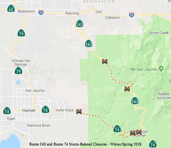 In February 2019, it was reported that an emergency contract for $8 million was
awarded to Ames Construction to make the repairs to Route 243 and Route 74
near Lake Fulmor to repair roadway damage from the Winter 2019 storms. In
mid-February, it was noted that there was a new collapse on Route 74, and
Route 243 washed out about a mile from where a waterfall destroyed the
road the day before, north of Lake Fulmor. The only way into Idyllwild is
from Palm Desert along Route 74, known as the Palms to Pines Highway,
Caltrans said. Even then, that path is open only to residents and business
owners/employees.
In February 2019, it was reported that an emergency contract for $8 million was
awarded to Ames Construction to make the repairs to Route 243 and Route 74
near Lake Fulmor to repair roadway damage from the Winter 2019 storms. In
mid-February, it was noted that there was a new collapse on Route 74, and
Route 243 washed out about a mile from where a waterfall destroyed the
road the day before, north of Lake Fulmor. The only way into Idyllwild is
from Palm Desert along Route 74, known as the Palms to Pines Highway,
Caltrans said. Even then, that path is open only to residents and business
owners/employees.
(Source: Press Enterprise, 2/15/2019)
In March 2019, it was reported that it may be Summer
2019 before Route 74 and Route 243 completely reopen to the general public
due to the extensive repair work required to restore the corridors, both
of which were severely damaged during a mid-February storm event, Caltrans
announced. "There are over 25 locations on Route 243 with damage,
including two locations with complete road loss," according to a Caltrans
statement. "Route 74 has over 40 locations that will require repairs. At
this time, Caltrans is estimating at least four months before public
access or reopening of both highways can take place." The worst of the
damage was in the area of Lake Fulmor, between Pine Cove and Banning,
where Route 243 completely collapsed and disappeared amid torrential
downpours and mud flows on Feb . 14. Another segment of the two-lane,
30-mile corridor, which is the primary north-south artery through the
southern half of the San Bernardino National Forest, also gave way south
of Idyllwild. The entire highway is out of service between I-10 and
Idyllwild, while the southern half between Mountain Center and Idyllwild
is accessible to residents and business owners. A 15-mile segment of Route 74 is out of service because of the storm damage, which caused washouts
and sinkholes. A portion of the highway at the Strawberry Creek crossing,
roughly three miles west of Mountain Center, collapsed after it was
compromised by runoff. The highway is closed from Valle Vista, just east
of Hemet, to Mountain Center. As of March 28, 2019, it was reported that
Ames Construction is continuing the $8 million emergency repairs to
roadbeds, slopes, culverts and other items of work on both Route 74 and
Route 243, working twenty-four (24) hour shifts to rebuild the routes. It
was estimated that by May 2019, Caltrans will provide access to motorists
on Route 74 under escort for three hours in the morning (4 a.m. to 7 a.m.)
and three hours in the late evening (6 p.m. to 9 p.m.). In late April
2019, Caltrans expected to open Route 243 from Idyllwild to Lake Fulmor.
The contractor will continue work to prepare for full access to motorists
on Route 243 with flagging conditions in the coming months.
(Source: Palm Desert Patch, 3/12/2019; CaltransDistrict
8 Commuter Alert, 3/28/2019)
In March 2019, it was reported that the main washout
was near RIV 51.0. By the middle of the month, most of the excavation has
ended at this site and now it is being rebuilt. In the past, even light
rain storms have eroded the soil sufficiently for rocks and boulders to
roll onto or pummel the highway. Based on its geotechnical consultants,
CalTrans is also reducing the steepness, which often was almost vertical,
along many portions of the highway. This work is extensive and the dirt
and rocks being removed fall below, blocking the lane next to the hill,
until that debris can be removed. Much of this dirt has and will be
transported to the work on Route 243 near Bay Tree Springs.
(Source: Idyllwild Crier, 3/14/2019)
In May 2019, it was reported that additional May rains
that further damaged the already crumbling roadways shattered by heavy
rains on Feb. 14. Caltrans officials said work on Route 74 was delayed at
least two months and reconstruction on Route 243 has no time frame for
completion. Initial estimates indicated Route 74 would reopen by Memorial
Day and Route 243 perhaps by year's end.
(Source: Desert Sun, 5/30/2019)
In June 2019, the CTC approved the following amendment
to the SHOPP: :Major Damage Restoration Item 20: 08-Riv-243 0.0/28.0 PPNO
3013N ProjID 0819000058. Route 243 Near Banning, from Route 74 to 0.3 mile
south of Wesley Street; also on Route 74 from Willowbrook Road to 0.1 mile
east of Devils Ladder Road (PM R47.0/70.0). Repair roadway washouts,
damaged pavement, embankment, guardrail, and culverts. PA&ED $200K;
PS&E $200K; R/W Sup $10K; Con Sup $1,200K; R/W Cap $200K; Const Cap
$7,950K; Total $9,760K.
(Source: June 2019 CTC Minutes, Agenda Item
2.1a.(1) MDR Item 20)
In June 2019, the CTC was informed of the following
emergency allocation: $32,650,000 for 08-Riv-243 0.0/28.0 PPNO 08-3013N.
ProjID 0819000058. Route 243 Near Banning, from Route 74 to 0.3 mile south
of Wesley Street; also on Route 74, from Willowbrook Road to 0.1 mile east
of Devils Ladder Road (PM R47.0/70.0). On February 14, 2019 intense
rainfall caused flooding, erosion, and undermining at various locations
along Route 243 and Route 74. This project will excavate and backfill
damaged roadway, remove debris, reconstruct slope embankment, and repair
guardrail and damaged drainage systems. After the receding of flood water
that then allowed assess to all damaged areas, supplemental funds became
necessary to address expanded damaged locations. This supplemental is the
same scope of work but is required to complete the project due to the
increased magnitude of the damaged roadway. R/W Cap. $200,000. Const.
$29,950,000 Const. Engr. $2,700,000.
(Source: June 2019 CTC Minutes Agenda Item 2.5f.(1)
Item 21)
SR-74 Bridge Replacement Project. Strawberry Creek Bridge: 08-Riv-74 53.4/54.7
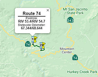 In May 2021, the CTC approved for future consideration of funding the following project:
08-Riv-74, PM 53.3/53.5. SR-74 Bridge Replacement Project.
Replace Strawberry Creek Bridge on Route 74 in Riverside County. (MND)
(PPNO 3005Q) (SHOPP). This project is located along Route 74 near Hemet in
Riverside County. The Department to proposes to replace Strawberry Creek
Bridge (Bridge No.56-0180 Post Mile 53.5) near Hemet on Route 74 in
Riverside County. The bridge has non-standard lane and shoulder widths.
Due to significant deterioration and non-standard features, there is a
need to replace the structures to meet current design, crash, and safety
standards. This project is currently programmed in the 2020 SHOPP for a
total of $13,002,000. Construction is estimated to begin in 2022. The
scope, as described for the preferred alternative, is consistent with the
project scope programmed by the Commission in the 2020 SHOPP. A Mitigated
Negative Declaration (MND) has been completed. The project will result in
less than significant impacts to the environment after mitigation. The
following resource areas may be impacted by the project: biological and
cultural resources. Avoidance and minimization measures will reduce any
potential effects on the environment. These measures include, but are not
limited to, restoration and enhancement of onsite riparian/riverine areas
and the purchase of mitigation bank credits, and preparation of Historic
American Engineering Record documentation for historic structures.
In May 2021, the CTC approved for future consideration of funding the following project:
08-Riv-74, PM 53.3/53.5. SR-74 Bridge Replacement Project.
Replace Strawberry Creek Bridge on Route 74 in Riverside County. (MND)
(PPNO 3005Q) (SHOPP). This project is located along Route 74 near Hemet in
Riverside County. The Department to proposes to replace Strawberry Creek
Bridge (Bridge No.56-0180 Post Mile 53.5) near Hemet on Route 74 in
Riverside County. The bridge has non-standard lane and shoulder widths.
Due to significant deterioration and non-standard features, there is a
need to replace the structures to meet current design, crash, and safety
standards. This project is currently programmed in the 2020 SHOPP for a
total of $13,002,000. Construction is estimated to begin in 2022. The
scope, as described for the preferred alternative, is consistent with the
project scope programmed by the Commission in the 2020 SHOPP. A Mitigated
Negative Declaration (MND) has been completed. The project will result in
less than significant impacts to the environment after mitigation. The
following resource areas may be impacted by the project: biological and
cultural resources. Avoidance and minimization measures will reduce any
potential effects on the environment. These measures include, but are not
limited to, restoration and enhancement of onsite riparian/riverine areas
and the purchase of mitigation bank credits, and preparation of Historic
American Engineering Record documentation for historic structures.
(Source: May 2021 CTC Agenda, Agenda Item 2.2c.(1))
In May 2021, the CTC approved the following
pre-construction SHOPP SB1 support phase allocation(s): (2b) #7.
$1,490,000 (PS&E; $1,295,000 programmed); $173,000 (R/W Sup; $150,000
programmed). 08-Riv-74 2.9/3.2, 53.4/54.7. PPNO 08-3005Q; ProjID
0816000001; EA 1G470. Route 74 Near Lake Elsinore, at Morrill Canyon
Bridge No. 56-0169; also near Hemet, at Strawberry Creek Bridge No.
56-0180 (PM 53.4/54.7). Replace structures/upgrade rails. (Concurrent
consideration of funding under Resolution E-21-39; May 2021.) Prog. year
21-22.
(Source: May 2021 CTC Agenda, Agenda Item 2.5b.(2b)
#7)
In March 2023, the CTC approved an additional
$3,104,000 in Construction Capital for the SHOPP Bridge Rehabilitation
project on Route 74, in Riverside County, to award the construction
contract. This project is located on Route 74 near the Cities of Lake
Elsinore and Hemet, at Morrill Canyon Bridge (№ 56-0169) and
Strawberry Creek Bridge (№ 56-0180), in Riverside County. The
project will rehabilitate the bridges by bridging the existing structures
with a new slab and substructure and upgrade bridge rails. In October
2022, the Department advertised the contract and held bid opening in
December 2022. The contract received two bids, of which the lowest bid is
42.2 percent above the Engineer’s Estimate (EE). The other bid is
83.9 percent over the EE. The cost increases on this project are largely
attributed to escalating unit prices due to inflation and the unforeseen
trend of material and labor shortages. In addition, the project has two
locations that are approximately 50 miles apart in remote areas, the first
is near Lake Elsinore. Due to the restricted lane closure requirement at
the Morrill Canyon bridge, the accelerated bridge construction method was
selected at this location. The Department has allowed multiple 55-hours
closures to lift the superstructure in place. The accelerated work has
resulted in an increase in the unit cost for the structure bid items which
was higher than anticipated. The second location is near Hemet in the
remote mountainous location, signalized traffic control will be used for
the stage construction of the Strawberry Creek bridge. As the type of work
is low in production it has also resulted in an increase in the unit cost
for the structure bid items.
(Source: March 2023 CTC Agenda, Agenda Item 2.5e.(8))
NamingIn Hemet, this is "Florida" Avenue in Hemet, and is "Idyllwild National Forest Highway" between Hemet and Route 243.
Historically, the entire segment (from Perris to Route 111) has been named the "Pines to Palms Highway".
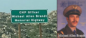 The portion of Route 74 between RIV 91.00 and RIV 96.00 in the County of
Riverside is named the "CHP Officer Michael Allen Brandt Memorial
Highway". It was named in memory of Officer Michael Allen Brandt,
who was born November 14, 1952, to Robert and Evelyn, in Bellingham,
Washington. In 1980, Officer Michael Allen Brandt, graduated from the
California Highway Patrol Academy with the Cadet Training Class IV-79 and
was assigned to the El Centro area and later transferred to the Indio
area, where he spent the remainder of his career. Throughout his career
with the CHP, Officer Brandt held several titles, some of which included a
Field Training Officer, Physical Methods of Arrest Instructor, Physical
Performance Program Coordinator, and cardio pulmonary resuscitation (CPR)
instructor. On April 6, 1987, Officer Brandt was killed in the line of
duty. While pursuing a reported drunk driver, he lost control of his
vehicle and struck a boulder, which caused his patrol vehicle to overturn.
He was taken to a nearby hospital, but succumbed to his injuries while in
transport. Officer Brandt was admired for his passion for life, loyalty to
others, love for his job as a California Highway Patrolman, dedication to
his family and friends, integrity, honesty, and quiet voice. He had a
competitive nature about him, both in sports and in his personal life, and
never turned down a challenge. Named by Assembly Concurrent Resolution
100, Resolution Chapter 109, on September 4, 2012.
The portion of Route 74 between RIV 91.00 and RIV 96.00 in the County of
Riverside is named the "CHP Officer Michael Allen Brandt Memorial
Highway". It was named in memory of Officer Michael Allen Brandt,
who was born November 14, 1952, to Robert and Evelyn, in Bellingham,
Washington. In 1980, Officer Michael Allen Brandt, graduated from the
California Highway Patrol Academy with the Cadet Training Class IV-79 and
was assigned to the El Centro area and later transferred to the Indio
area, where he spent the remainder of his career. Throughout his career
with the CHP, Officer Brandt held several titles, some of which included a
Field Training Officer, Physical Methods of Arrest Instructor, Physical
Performance Program Coordinator, and cardio pulmonary resuscitation (CPR)
instructor. On April 6, 1987, Officer Brandt was killed in the line of
duty. While pursuing a reported drunk driver, he lost control of his
vehicle and struck a boulder, which caused his patrol vehicle to overturn.
He was taken to a nearby hospital, but succumbed to his injuries while in
transport. Officer Brandt was admired for his passion for life, loyalty to
others, love for his job as a California Highway Patrolman, dedication to
his family and friends, integrity, honesty, and quiet voice. He had a
competitive nature about him, both in sports and in his personal life, and
never turned down a challenge. Named by Assembly Concurrent Resolution
100, Resolution Chapter 109, on September 4, 2012.
(Image source: Gribblenation Blog, Find a Grave)
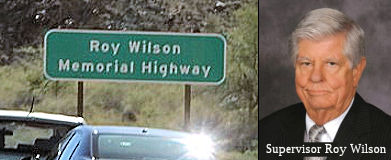 The portion of Route 74 beginning four
miles west of the entrance to the Santa Rosa and San Jacinto Mountains
National Monument visitor center to the entrance of the visitor center, ,
in the City of Palm Desert and Riverside County (~ RIV R88.34 to RIV
R92.34) is named the "Roy Wilson Memorial Highway". This segment
was named in memory of Supervisor Roy Wilson, who was best known for his
role as Riverside County Supervisor for the 4th District, where his
commitment to serving his community greatly advanced the quality of life
in Coachella Valley until his death in 2009. Roy Wilson was known to his
constituents, colleagues, neighbors, and friends as an exceptional leader
and a selfless, dedicated public servant in the Coachella Valley. Roy
Wilson was also a strong advocate for conservation of the scenic lands
along Route 74, including the Santa Rosa and San Jacinto Mountains
National Monument. Roy Wilson was involved in ongoing efforts to protect
the scenic beauty and improve the safety of Route 74 as well as promote
involvement of the communities along Route 74 in its betterment. As
Riverside County Supervisor for the 4th District, Roy Wilson was also
instrumental in the successful effort to prepare and implement the
Coachella Valley Multiple Species Habitat Conservation Plan/Natural
Community Conservation Plan, which will result in the establishment of a
comprehensive and coherent Multiple Species Reserve System including lands
along Route 74 in the Santa Rosa and San Jacinto Mountains. Roy Wilson
also served on the governing board of the South Coast Air Quality
Management District for 22 years Named by Assembly Concurrant Resolution
(ACR) 109, 6/2/2010, Resolution Chapter 31.
The portion of Route 74 beginning four
miles west of the entrance to the Santa Rosa and San Jacinto Mountains
National Monument visitor center to the entrance of the visitor center, ,
in the City of Palm Desert and Riverside County (~ RIV R88.34 to RIV
R92.34) is named the "Roy Wilson Memorial Highway". This segment
was named in memory of Supervisor Roy Wilson, who was best known for his
role as Riverside County Supervisor for the 4th District, where his
commitment to serving his community greatly advanced the quality of life
in Coachella Valley until his death in 2009. Roy Wilson was known to his
constituents, colleagues, neighbors, and friends as an exceptional leader
and a selfless, dedicated public servant in the Coachella Valley. Roy
Wilson was also a strong advocate for conservation of the scenic lands
along Route 74, including the Santa Rosa and San Jacinto Mountains
National Monument. Roy Wilson was involved in ongoing efforts to protect
the scenic beauty and improve the safety of Route 74 as well as promote
involvement of the communities along Route 74 in its betterment. As
Riverside County Supervisor for the 4th District, Roy Wilson was also
instrumental in the successful effort to prepare and implement the
Coachella Valley Multiple Species Habitat Conservation Plan/Natural
Community Conservation Plan, which will result in the establishment of a
comprehensive and coherent Multiple Species Reserve System including lands
along Route 74 in the Santa Rosa and San Jacinto Mountains. Roy Wilson
also served on the governing board of the South Coast Air Quality
Management District for 22 years Named by Assembly Concurrant Resolution
(ACR) 109, 6/2/2010, Resolution Chapter 31.
(Image sources: Walkabout With Wheels, Palm Springs Life)
StatusThere is currently work underway to explore some realignments of this route, in particular, the portion from Hemet to Corona/Lake Elsinore.
 Freeway
[SHC 253.1] Entire route. Added to the Freeway and Expressway system in 1959.
 National Trails
 This route is part of the De Anza National Historic Trail.
Other WWW Links Statistics
Overall statistics for Route 74:
 Scenic Route
[SHC 263.1] Entire route: I-5 near San Juan Capistrano to Route 111 (All).
Eligible for Scenic Highway status per [SHC 263.2]. The following portions have been officially designated as Scenic Highway and are signed:
 Interregional Route
[SHC 164.14] Entire route.
 Pre-1964 Legislative Route
The route that was to become LRN 74 was first defined in 1931 by Chapter 82 as the route from Vallejo to [LRN 8] (although the April 1931 CHPW describes the route as being from LRN 8 near Cordelia via American Canyon to LRN 14). This eventually became part of signed Route 29.
 The situation in 1931 was that traffic between the Sacramento Valley and the bay cities
could not find the direct and most advantageous passage from LRN 8 (near
Cordelia) to LRN 14 (US 40 near Crockett) over connected state highways.
LRN 7, at the time, went down from Cordelia to Benicia along what was
later Sign Route 21 and it today's I-680—it was signed US 40 at the
time. It then crossed at Martinez via the Martinez Ferry, where US 40
picked up LRN 14 to return to Crockett. A better road and bridge facility
implied almost exclusive use of a county highway from the Napa Wye (where
Sign Route 29 and Sign Route 12 split today) to the Carquinez Straits. It
was felt that a state route should be established to service the through
traffic that was forced onto county roads. The route proposed for LRN 74
was a favorable route from Cordelia south to Vallejo by way of American
Canyon. This route was 5 miles shorter than the route using the Napa Wye
and 9 miles shorter than the routing through Martinez. The new route
avoided the disadvantageous passage over steep intersecting streets in
Vallejo. It was considered appropriate to add it to the state highway
system as it would serve a very large volume of state traffic now carried
over a county highway.
The situation in 1931 was that traffic between the Sacramento Valley and the bay cities
could not find the direct and most advantageous passage from LRN 8 (near
Cordelia) to LRN 14 (US 40 near Crockett) over connected state highways.
LRN 7, at the time, went down from Cordelia to Benicia along what was
later Sign Route 21 and it today's I-680—it was signed US 40 at the
time. It then crossed at Martinez via the Martinez Ferry, where US 40
picked up LRN 14 to return to Crockett. A better road and bridge facility
implied almost exclusive use of a county highway from the Napa Wye (where
Sign Route 29 and Sign Route 12 split today) to the Carquinez Straits. It
was felt that a state route should be established to service the through
traffic that was forced onto county roads. The route proposed for LRN 74
was a favorable route from Cordelia south to Vallejo by way of American
Canyon. This route was 5 miles shorter than the route using the Napa Wye
and 9 miles shorter than the routing through Martinez. The new route
avoided the disadvantageous passage over steep intersecting streets in
Vallejo. It was considered appropriate to add it to the state highway
system as it would serve a very large volume of state traffic now carried
over a county highway.
In 1935, it was codified into the highway code as "Vallejo to [LRN 8]". However it was quickly amended by Chapter 274 to be the following:"A point on [LRN 8] near the Napa Y to Cordelia via Vallejo and Benecia". This amendment changed the route from a simple route from the Napa Wye to Vallejo to a U-shaped route. It added Benicia Blvd across to Benicia, and then went up former US 40 (which was resigned as Sign Route 21 in 1935; Sign Route 21 became Route 21 in 1964, later, I-680) to near Cordelia. The segment from Benicia to Cordelia was essentially a transfer from LRN 7, with LRN 7 assuming the routing of its former second segment from Cordelia to LRN 14 near Crockett. This had the side effect of dropping the Martiez-Benicia Ferry approach along 5th Street in Benicia from the state highway system.
Complicating and confusing all of this was LRN 104, which was defined in 1933 with a third segment running from "[LRN 8] to [LRN 7] through American Canyon". The second segment of LRN 104 ended at LRN 8 near Shellville (now Schellville), so the specific starting point on LRN 8 for the third segment is unclear. This third segment of LRN 104 appears to duplicate LRN 74, which is probably why in 1937, the third segment of LRN 104 was deleted. Confusingly2, the legislation deleting the third segment changed the end of the second segment of LRN 104 to the Napa "Y" (which then duplicated LRN 8 between Shellville and the Napa "Y"), and so two years later in 1939, the reference to the Napa "Y" was changed back to Shellville.
In 1940 the legislature approved for Department of Public Works to
formally request that control of the Martinez-Benicia Ferry be transferred
by the American Toll Bridge company to the cities of Martinez and Benicia.
The Martinez-Benicia Ferry was transferred to the City of Martinez on
January 1, 1941. The city of Benicia ultimately withdrew from
becoming an owner of the ferry which left it under sole ownership of the
City of Martinez.
(Source: Gribblenation Blog "The original alignment of US Route 40 over the Martinez-Benicia Ferry and Carquinez Scenic Drive")
In 1947 during the 1st executive session, Chapter 13 added a connection to the Carquinez Bridge: "...including a connection from Vallejo to [LRN 7] near the Carquinez Bridge", as well as a connection to the Martinez Ferry "and a connection in Benicia from M and East Second Street to East Fifth and C Street."
In 1953, Chapter 1737 made removal of the clause about the Benecia Ferry ("and a connection in Benicia from M and East Second Street to East Fifth and C Street.") contingent on the acquisition by the Department of Public Works of the ferry system operated across the Carquinez Straights between the cities of Benecia and Martinez ("Section [changes to LRN 74] and Section 9 [changes to LRN 75] shall become effective upon the acquisition by the Department of Public Works of the ferry system operated across the Carquinez Straights between the cities of Benecia and Martinez"). The change to LRN 75 was the addition of another segment from the original LRN 75, N of Walnut Creek, to a connection with LRN 74 in Benicia. This was done because the city of Martinez was about to close down the ferry system across the straights, and it was necessary to keep the ferry in operation to serve numerous refineries, chemical plants, steel companies, and other industries necessary for national defense, workers commuting both to and from such industries, and the extremely important Benecia Arsenal. The ferry was acquired in 1953.
In 1957, Legislative Chapter 1911 changed the definition LRN 75 segment (b) from ending at LRN 74 in Benicia to "near Benicia." This change was meant to reflect the adopted freeway routing of the planned Benicia-Martinez Highway Bridge.
In 1959, Chapter 1062 extended the route to begin at [LRN 6] near Napa, and removed the contingency section as it was no longer applicable.
Sparker on AAroads noted the following:
(Source: Sparker on AAroads, "Re: Interstate 780 and California State Route 141", 2/22/2019)
LRN 74 was unusual in that it was U-shaped, consisting of Pre-1964 Route 29 from Pre-1964 Route 12/LRN 8 at Napa Junction south to the intersection of present Route 29 and Maine Street in Vallejo; there it split into the main stem which extended east on Maine to Benicia-Vallejo Road, then utilized that into Benicia; the surface street was never signed as a pre-1964 route prior to 1964. However, Pre-1964 Route 29 south from the intersection in Vallejo to I-80 just north of the Carquinez Bridge(s) was a LRN 74 spur. Once in Benicia, it spawned another spur to the ferry terminal to Martinez, across the Carquinez Strait; this, and the remainder of LRN 74 north to Cordelia Junction (old US 40/LRN 7) were signed as part of Pre-1964 Route 21, which utilized the ferry to get to its southern section in Contra Costa and Alameda counties. By late 1962 the initial section of I-680 from the present I-80/780 interchange in Vallejo east toward Benicia had opened, and LRN 74 was rerouted over that freeway; two years later Route 141 subsumed the section of LRN 74 between Route 29 and I-80, although the east end had been shunted south to the NW end of (then) I-680, which entailed about a 2-3 block right-angle shunt south of Benicia-Vallejo Road. Route 141 received signage circa 1968; this involved trailblazers and an initial reassurance shield on EB Maine, directional changes where the route shifted to Benicia-Vallejo Road, and I-680 (later 780) trailblazers at the shunt down to the end of that freeway about a quarter-mile west of I-80. The sole Route 141 indication WB was at the stub-end of the I-680/780 freeway, which was originally planned to continue on to Route 37 via Mare Island. That freeway routing was deleted from the system in 1976 along with a batch of others statewide as part of then-Caltrans director Adriana Gianturco's orders to slash as much urban proposed freeway mileage as possible (with legislative concurrence). Signage remained on the surface segment of Route 141 until that too was relinquished circa 1982. One "straggler" Route 141 sign remained at the Maine/B-V Road intersection until about 1989, but it disappeared about that time.

 The third iteration of the Lincoln Highway was routed out of Sacramento to the West along LRN 7. It diverted to use Route 12
(LRN 8) between Cordelia and Napa, and Route 29 (LRN 74) down American
Canyon to return to LRN 7 near Vallejo, where it met LRN 14 to LRN 5,
where it then crossed into San Francisco (originally via the Ferry, and
later the Oakland Bay Bridge on LRN 68). The route originally terminated
in Lincoln Park, six miles west of the ferry landing at the foot of Market
Street. The Lincoln Highway ended opposite the Palace of the Legion of
Honor at a small monument marking the spot. The last few miles (of the
highway) were California Street.
The third iteration of the Lincoln Highway was routed out of Sacramento to the West along LRN 7. It diverted to use Route 12
(LRN 8) between Cordelia and Napa, and Route 29 (LRN 74) down American
Canyon to return to LRN 7 near Vallejo, where it met LRN 14 to LRN 5,
where it then crossed into San Francisco (originally via the Ferry, and
later the Oakland Bay Bridge on LRN 68). The route originally terminated
in Lincoln Park, six miles west of the ferry landing at the foot of Market
Street. The Lincoln Highway ended opposite the Palace of the Legion of
Honor at a small monument marking the spot. The last few miles (of the
highway) were California Street.
© 1996-2024 Daniel P. Faigin.
Maintained by: Daniel P. Faigin
<webmaster@cahighways.org>.
 Route 73
 Route 75