
 California Highways:
Click here for a key to the symbols used. An explanation of acronyms may be found at the bottom of the page.
 Routing
 Post 1964 Signage History
In 1963, this route was defined as "Route 80 near Colfax to Route 49 near Grass Valley."
In 1972, Chapter 1216 changed "Route 49" to "Route 20".
In 2020, Chapter 82 authorized the relinquishment to the City of Grass Valley the portion of Route 174 within its city limits. It renumbered the route definition as (a), and added the following clauses:
The segments within Grass Valley (03-Nev-174-PM 9.6/10.2, 03-Nev-20-PM
12.9/13.3) were relinquished in August 2022, when the CTC authorized
relinquishment of right of way in the city of Grass Valley along Route 174
(Colfax Avenue) from Route 20 to Race Street, along Route 20 on Tinloy
Street from South Auburn Street to Bank Street, on Hansen Way from Colfax
Avenue to East Bennett Street, and along Neal Street and South Auburn
Street, under the terms and conditions as stated in the relinquishment
agreement dated October 13, 2021 and determined to be in the best interest
of the State. The relinquishment was authorized by Chapter 82,
Statutes of 2020, which amended Section 474 of the Streets and Highways
Code.
(Source: August 2022 CTC Agenda, Agenda Item 2.3c)
A discussion of the Highways to Boulevards program during the March 2022
CTC meeting identified the following segment(s) as potential Highways to
Boulevards conversion projects: The segment of Route 174 in the Grass
Valley city limits.
(Source: March 2022 CTC Agenda, Agenda Item 4.3)
 Pre 1964 Signage History
This was LRN 25, defined in 1933. It was not signed before 1963.
Route 174 was not defined as part of the initial state signage of routes in 1934. It is unclear what (if any) route was signed as Route 174 between 1934 and 1964.
 Status
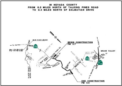
Maple Way/You Bet Road Improvement (03-Nev-174, PM 2.7/4.6)
 In September 2016, Caltrans published an Initial Study
and Mitigated Negative Declaration regarding this project. The project
proposes to improve safety along Route 174 in Nevada County from Maple Way
to You Bet Road, post mile 2.74 to 4.63 by realigning and widening the
highway and providing a clear recovery zone. The project is located
approximately 5.7 miles southeast of Grass Valley. Caltrans notes that
this 1.9 mile segment of roadway experienced a total of 30 collisions
during the three year period from April 1, 2010 to March 31, 2013, and
that the observed total accident rate is almost 1.65 times higher than the
statewide average for a similar type facility and the observed fatal
accident rate is 7 times higher than the statewide average for a similar
type facility. They state that the proposed project will increase curve
radii, widen shoulders, and improve the clear recovery area. This will
provide several benefits to traveler safety. First and foremost, the
increased curve radii will reduce the potential for a vehicle to lose
control. The wider shoulders will not only provide more room for
pedestrians and bicycles to travel the corridor, but they also provide
room for an errant vehicle to regain control without leaving the roadway.
The removal of fixed objects such as trees and embankments from the clear
recovery area will reduce the severity of a run off road collision.
Lastly, the improved curve radii, wider shoulders, and removal of fixed
objects along with roadway will improve sight distances for roadway users,
which will allow more time to identify and react to potential hazards
along the highway. They only presented a single build alternative and a
no-built alternative.
In September 2016, Caltrans published an Initial Study
and Mitigated Negative Declaration regarding this project. The project
proposes to improve safety along Route 174 in Nevada County from Maple Way
to You Bet Road, post mile 2.74 to 4.63 by realigning and widening the
highway and providing a clear recovery zone. The project is located
approximately 5.7 miles southeast of Grass Valley. Caltrans notes that
this 1.9 mile segment of roadway experienced a total of 30 collisions
during the three year period from April 1, 2010 to March 31, 2013, and
that the observed total accident rate is almost 1.65 times higher than the
statewide average for a similar type facility and the observed fatal
accident rate is 7 times higher than the statewide average for a similar
type facility. They state that the proposed project will increase curve
radii, widen shoulders, and improve the clear recovery area. This will
provide several benefits to traveler safety. First and foremost, the
increased curve radii will reduce the potential for a vehicle to lose
control. The wider shoulders will not only provide more room for
pedestrians and bicycles to travel the corridor, but they also provide
room for an errant vehicle to regain control without leaving the roadway.
The removal of fixed objects such as trees and embankments from the clear
recovery area will reduce the severity of a run off road collision.
Lastly, the improved curve radii, wider shoulders, and removal of fixed
objects along with roadway will improve sight distances for roadway users,
which will allow more time to identify and react to potential hazards
along the highway. They only presented a single build alternative and a
no-built alternative.
(Source: Nevada 174 Highway Realignment, Nevada County 03-NEV-174-PM: 2.7-4.6 Initial Study with a Mitigated Negative Declaration, September 2016)
In December 2016, the CTC approved for future consideration of funding a project that will realign the roadway, widen shoulders, and add a recovery zone on Route 174 near the city of Grass Valley (03-Nev-174, PM 2.7/4.6). The project is programmed in the 2016 State Highway Operation and Protection Program. The total programmed amount is $28,456,000 for capital and support. Construction is estimated to begin in Fiscal Year 2017-18. The scope, as described for the preferred alternative, is consistent with the project scope programmed by the Commission in the 2016 State Highway Operation and Protection Program.
In May 2017, it was reported that Caltrans had started
to hold public meetings to present information for a project that proposes
to improve safety along Route 174 in Nevada County from Maple Way to Your
Bet Road. the project would include realigning curves, widening shoulders,
adding a left-turn lane at Greenhorn Access Road and improving the Clear
Recovery Zone (CRZ) on Route 174 from post mile 2.7 to post mile 4.6 in
Nevada County. This project proposed to help reduce the number and
severity of collisions within this segment of Route 174. This project is
scheduled to go to construction during the summer of 2019.
(Source: Yubanet, 5/22/2017)
In June 2017, it was reported that Caltrans has
completed initial environmental review and design processes for road
improvements along the two miles of Route 174 between Maple Way and You
Bet Road, which were revised after public input was provided at open house
events in May 2015 and June 2016, and it plans to begin the process of
acquiring any parcels or portions of parcels that will be impacted by the
project this summer. Those improvements include realigning several curves
and widening lanes— which currently range from 11 to 11.3 feet wide
— to the state standard of 12 feet wide. Caltrans also plans to
widen shoulders — which currently range from one inch to five and a
half feet — to 8 feet, and add 20 feet of "clear recovery zone"
beyond the lane on each side of the highway, which includes the eight foot
shoulder and an additional 12 feet of area clear of any trees, poles, or
other obstructions. Currently, Caltrans has identified 49 parcels that
will be impacted, and will send out letters to the owners of those
properties notifying them of the impact within the next few months.
Construction is slated to begin during the summer of 2019 and be completed
by the fall of 2020.
(Source: The Union, 6/9/2017)
The following project was included in the final adopted 2018 SHOPP in March 2018: PPNO 4451. 03-Nevada-174 2.7/4.7. Route 174 Near Rollins Lake, from Maple Way to You Bet Road. Realign roadway curves. Begin Con: 7/1/2019. Total Project Cost: $28,803K.
 In January 2019, there was a briefing at the CTC meeting
from the Save Highway 174 group. The briefing was not included in the CTC minutes, but according to their
website, the group "consists of affected property owners, residents and
citizens of Nevada County who support reasonable safety improvements, but
are concerned with the current design standard for the widening and
realignment project proposed by Caltrans for a 1.9 mile portion of Route 174." A briefing on the site to the NCTC in September 2017 notes that the
concern is over a 1.9mi segment of Route 174 from Maple Way to You Bet
Road. It notes the highway will be leveled, straightened, and widened --
doubling to a minimum width of 64', including a 20' clear recovery zone.
There would be additional right of way required approx. 120' to 150', and
additional clearing to relocate electrical wires. There would be a total
acquisition of over 14 acres from 53 parcels, and removal of over 1,700
conifers, oaks, and smaller trees. Their goals are to create a highway
design standard and right-of-way width that is significantly less in scope
but still preserves safety. In July 2017, the Nevada County Board of
Supervisors wrote a letter to Caltrans, District 3 Director, requesting
that Caltrans "reassess this project and its scope of work" and to
"increase public outreach for input on the project and its design". They
appear to have a large number of concerns about the EIR, believing it should not have been a mitigated EIR.
In January 2019, there was a briefing at the CTC meeting
from the Save Highway 174 group. The briefing was not included in the CTC minutes, but according to their
website, the group "consists of affected property owners, residents and
citizens of Nevada County who support reasonable safety improvements, but
are concerned with the current design standard for the widening and
realignment project proposed by Caltrans for a 1.9 mile portion of Route 174." A briefing on the site to the NCTC in September 2017 notes that the
concern is over a 1.9mi segment of Route 174 from Maple Way to You Bet
Road. It notes the highway will be leveled, straightened, and widened --
doubling to a minimum width of 64', including a 20' clear recovery zone.
There would be additional right of way required approx. 120' to 150', and
additional clearing to relocate electrical wires. There would be a total
acquisition of over 14 acres from 53 parcels, and removal of over 1,700
conifers, oaks, and smaller trees. Their goals are to create a highway
design standard and right-of-way width that is significantly less in scope
but still preserves safety. In July 2017, the Nevada County Board of
Supervisors wrote a letter to Caltrans, District 3 Director, requesting
that Caltrans "reassess this project and its scope of work" and to
"increase public outreach for input on the project and its design". They
appear to have a large number of concerns about the EIR, believing it should not have been a mitigated EIR.
(Source: Save Highway 174 as of 4/7/2019; image source: Caltrans Dist 3 on FB)
In October 2019, the CTC approved the following SHOPP
Safety allocation: 03-Nev-174 2.7/4.6 PPNO 4451 Proj ID 0314000152 EA
4F370. On Route 174 Near Rollins Lake, from Maple Way to You Bet Road.
Outcome/Output: Improve safety by realigning curves, adding a southbound
left turn lane at Greenhorn Access Road, constructing turnouts, and
improving clear recovery zone. This project will reduce the number and
severity of collisions. $20,105,000
(Source: October 2019 CTC Agenda, Agenda Item
2.5f.(3) #3)
In July 2020, it was reported that Caltrans was
starting construction on Aug. 3 on a $27.1 million safety improvement
project on Route 174 between Maple Way and You Bet Road in Nevada County.
The project is realigning several curves, widening shoulders, adding a
southbound left turn pocket at Greenhorn Access Road and improving the
clear recovery zone, allowing errant vehicles to regain control. The
project also upgrades pedestrian and bicycle facilities along a beautiful
stretch of Sierra-area highway, continuing our commitment to multi-modal
methods of transportation. DeSilva Gates Construction of Sacramento is the
primary contractor for the project. Scheduled construction work for the
2020 season includes preparation for AT&T utility relocation, drainage
improvements, tree removal, and roadway widening at various locations.
This anticipated work will prepare the roadway for core project
improvements planned for the 2021 construction season.
(Source: The Union, 7/28/2020)
In April 2021, it was reported that construction was
resuming on a $27.1 million safety improvement project on Route 174
between Maple Way and You Bet Road in Nevada County. The project, which
began in August 2020, is realigning several curves, widening shoulders,
adding a southbound left-turn pocket at Greenhorn Access Road and
improving the clear recovery zone for errant vehicles to regain control.
DeSilva Gates Construction of Sacramento is the primary contractor for the
project and completion is anticipated in Fall 2021.
(Source: Caltrans Press Release, 4/14/2021)
In June 2021, it was reported that construction was
continuing on Route 174 between You Bet Road and Greenhorn Access Road in
Nevada County. Work on the safety improvement project was shifting to six
days a week for the forseeable future with one-way traffic control.
Grading work is currently continuing on the project in preparation for
paving of realigned segments and newly widened shoulders. The project,
which began in August 2020, is realigning several curves, widening
shoulders, adding a southbound left-turn pocket at Greenhorn Access Road
and improving the clear recovery zone for errant vehicles to regain
control. DeSilva Gates Construction of Sacramento is the primary
contractor for the project and completion is anticipated in Fall 2021.
(Source: The Union, 6/11/2021)
In November 2021, it was reported that Caltrans has
completed major roadway improvements with minor construction items
remaining on the Route 174 Safety Improvement Project between You Bet Road
and Maple Way in Nevada County. The $27.1 million safety improvement
project, which began in August 2020, has realigned several curves, widened
shoulders, added a southbound left-turn pocket at Greenhorn Access Road
and improved the clear recovery zone for errant drivers to regain control.
Remaining minor work includes erosion control, shoulder painting, sign
installation, fence relocation, the installation of speed radar feedback
signs and other miscellaneous items.
(Source: YubaNet.Com, 11/21/2021)
Relinquishment in Grass Valley (03-Nev-174 9.6/10.2)
In June 2021, the CTC approved the following SHOPP
amendment: 03-Nev-174 9.7/10.1 9.6/10.2. PPNO
4450; ProjID 0313000047; EA 03-3F680. Route 174 In Grass Valley, from Park
Race Street to Route 20, including frontage streets.
Financial Contribution Only (FCO) for construction capital to the City
of Grass Valley to relinquish a portion of the route. Park
Street to Route 20. Upgrade pedestrian infrastructure to meet Americans
with Disabilities Act (ADA) requirements. Note: This project
will be a Financial Contribution Only (FCO) for construction capital
to the City of Grass Valley to relinquish this route. Update postmiles,
description, performance, and program code to reflect this change. Const
Cap: $1,660K. Total: $2,766K.
(Source: June 2021 CTC Agenda, Agenda Item
2.1a.(2d) #10)
In October 2021, the CTC approved the following
allocation for construct/construction support phases: $1,950,000.
03-Nev-174 9.6/10.2. PPNO 03-4450; ProjID 0313000047; EA 3F680. Route 174
In Grass Valley, from Race Street to Route 20, including frontage
streets. Outcome/Output: Financial Contribution Only (FCO) for
construction capital to the City of Grass Valley to relinquish a portion
of the route. Allocation: CON ENG $360,000; CONST $1,660,000. (Four month
time extension for CONST and CON ENG approved under Waiver 21-59; June
2021.)
(Source: October 2021 CTC Agenda, Agenda Item
2.5b.(1) #3)
 Naming
 This route is named the "Officer Bill C. Bean Jr. Memorial Highway". Officer Bean
was a Sacramento Police officer who died on February 9, 1999 in the line
of duty during a traffic stop in the Del Paso Heights of North Sacramento.
Bean graduated from Colfax High School in 1989 where he later coached
football. He started his career in law enforcement at the Placer County
Sheriff's Department in May 1991 and later joined the Sacramento Police
Department in April 1995. Officer Bean had served with the Sacramento
Police Department for eight years at the time of his death. Bean was shot
and killed as he and his partner attempted to stop a man wanted on an
outstanding warrant. The suspect vehicle pulled over and started to drive
again, leading the officers on a low-speed pursuit. The vehicle stopped
after becoming disabled in the area of Knightlinger Street and South
Avenue. As Officer Bean exited the patrol car and attempted to talk to the
subject, the man opened fire, striking him several times. Bean had been
wearing “body armor” but a bullet entered through an arm hole
and hit him behind his left shoulder. Officer Bean's partner returned fire
but did not strike the suspect, who was captured several hours later after
a manhunt. The man was convicted of Officer Bean's murder and was
subsequently sentenced to life in prison without parole on December 18th,
2003. Named by Assembly Concurrent Resolution 68, Chapter 110, on
September 14, 1999.
This route is named the "Officer Bill C. Bean Jr. Memorial Highway". Officer Bean
was a Sacramento Police officer who died on February 9, 1999 in the line
of duty during a traffic stop in the Del Paso Heights of North Sacramento.
Bean graduated from Colfax High School in 1989 where he later coached
football. He started his career in law enforcement at the Placer County
Sheriff's Department in May 1991 and later joined the Sacramento Police
Department in April 1995. Officer Bean had served with the Sacramento
Police Department for eight years at the time of his death. Bean was shot
and killed as he and his partner attempted to stop a man wanted on an
outstanding warrant. The suspect vehicle pulled over and started to drive
again, leading the officers on a low-speed pursuit. The vehicle stopped
after becoming disabled in the area of Knightlinger Street and South
Avenue. As Officer Bean exited the patrol car and attempted to talk to the
subject, the man opened fire, striking him several times. Bean had been
wearing “body armor” but a bullet entered through an arm hole
and hit him behind his left shoulder. Officer Bean's partner returned fire
but did not strike the suspect, who was captured several hours later after
a manhunt. The man was convicted of Officer Bean's murder and was
subsequently sentenced to life in prison without parole on December 18th,
2003. Named by Assembly Concurrent Resolution 68, Chapter 110, on
September 14, 1999.
(Image source: Flikr: Officer Down Memorial Page; Additional information: Calif Police Officers Memorial Foundation; ABC 10)
 Named Structures
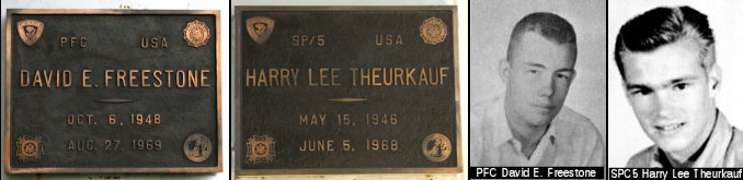 Bridge 17-50 on Route 20, at the Route 20/Rout 174 separation in Nevada county, is named the "David E. Freestone and
Harry Lee Theurkauf Memorial Bridge". It was built in 1970, and was
named by Assembly Concurrent Resolution 43, Chapter 220, in 1971. Private
First Class David Edward Freestone was a casualty of the Vietnam War. As a
member of the Army, PFC Freestone served our country until August 27th,
1969 in Binh Duong, South Vietnam. He was 20 years old and was not
married. David died from small arms fire. Specialist Five Harry Lee
Theurkauf was also a casualty of the Vietnam War. As a member of the Army,
SP5 Theurkauf served our country until June 5th, 1968 in Binh Duong, South
Vietnam. He was 22 years old and was not married. Harry died from
artillery fire.
Bridge 17-50 on Route 20, at the Route 20/Rout 174 separation in Nevada county, is named the "David E. Freestone and
Harry Lee Theurkauf Memorial Bridge". It was built in 1970, and was
named by Assembly Concurrent Resolution 43, Chapter 220, in 1971. Private
First Class David Edward Freestone was a casualty of the Vietnam War. As a
member of the Army, PFC Freestone served our country until August 27th,
1969 in Binh Duong, South Vietnam. He was 20 years old and was not
married. David died from small arms fire. Specialist Five Harry Lee
Theurkauf was also a casualty of the Vietnam War. As a member of the Army,
SP5 Theurkauf served our country until June 5th, 1968 in Binh Duong, South
Vietnam. He was 22 years old and was not married. Harry died from
artillery fire.
(Image source: Waymarking; Virtual Wall Vietnam Veterans Memorial; HonorStates.org)
 Business Routes
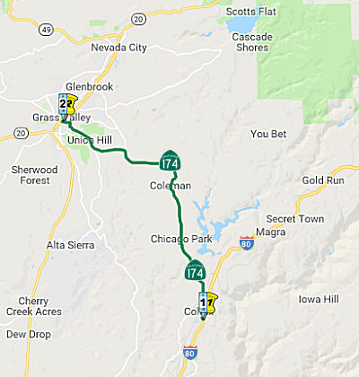
There is a business routing through the town of Colfax. It uses Auburn St., Grass Valley St., and Main St. The routing separates from Route 174 just north of the I-80 junction and rejoins the highway north of town.
 Scenic Route
[SHC 263.7] From the Bear River to the Grass Valley city limits.
 Other WWW Links
 Statistics
Overall statistics for Route 174:
 Pre-1964 Legislative Route
In 1933, the routes from "[LRN 60] via Manchester Avenue to [LRN 2] near Miraflores" and "[LRN 2] near Orange County Hospital to Main Street, Santa Ana via Santa Ana Boulevard" were added to the state highway system. In 1935, these routes were added to the highway code as LRN 174:
In 1957, Chapter 36 deleted segment (b), and changed the origin of (a) to
"[LRN 60] west of Inglewood via Manchester Avenue
to [LRN 2] near Miraflores". Segment (b) appears to have run from
what is now UCI Medical Center to Main Street along what is now Chapman.
This makes the most sense, as UCI Medical Center is near what was
Manchester, near where Manchester met LRN 2. The discontinuity was due to
a small segment running along former LRN 2. This segment was removed from
state control with the construction of the US 101, later I-5 freeway. This
correlates with the fact that US 101 continued north on Main St. to
Chapman Avenue, and across Chapman to near Lewis (i.e., Manchester). Thus,
Segment (b) was likely signed as US 101. Main Street was LRN 184. It looks
like segment (b) was later added to LRN 2.
Later in 1957, Chapter 1911 clarified the terminus: "… to [LRN 2] near Santa Ana".
The routing, as of 1963, ran from Route 1 W of Inglewood to US 101 near Santa Ana (near Katella and Anaheim). This was (former) Route 42 (which itself is former Route 10). Route 42 was later reallocated to what is now I-105, although I-105 runs closer to Imperial Highway. Route 42 ran along Manchester Avenue and Firestone Avenue and Manchester again to Los Angeles Street, which became Anaheim. LRN 174 also included portions of US 101 as it was constructed as freeway between the junction with Route 42 near Rosecrans and the junction with surface US 101 (LRN 2) near Anaheim and Katella. Miraflores is approximately where Main Street meets N. Park Blvd in Santa Ana. As the freeway portion of the route was completed, this was also treated as LRN 2.
This was actually a significant route in its day, prompting numerous articles in California Highways and Public Works.
© 1996-2020 Daniel P. Faigin.
Maintained by: Daniel P. Faigin
<webmaster@cahighways.org>.
 From Route
  Route 173
 Route 175