
 California Highways:
Click here for a key to the symbols used. An explanation of acronyms may be found at the bottom of the page.
 Routing
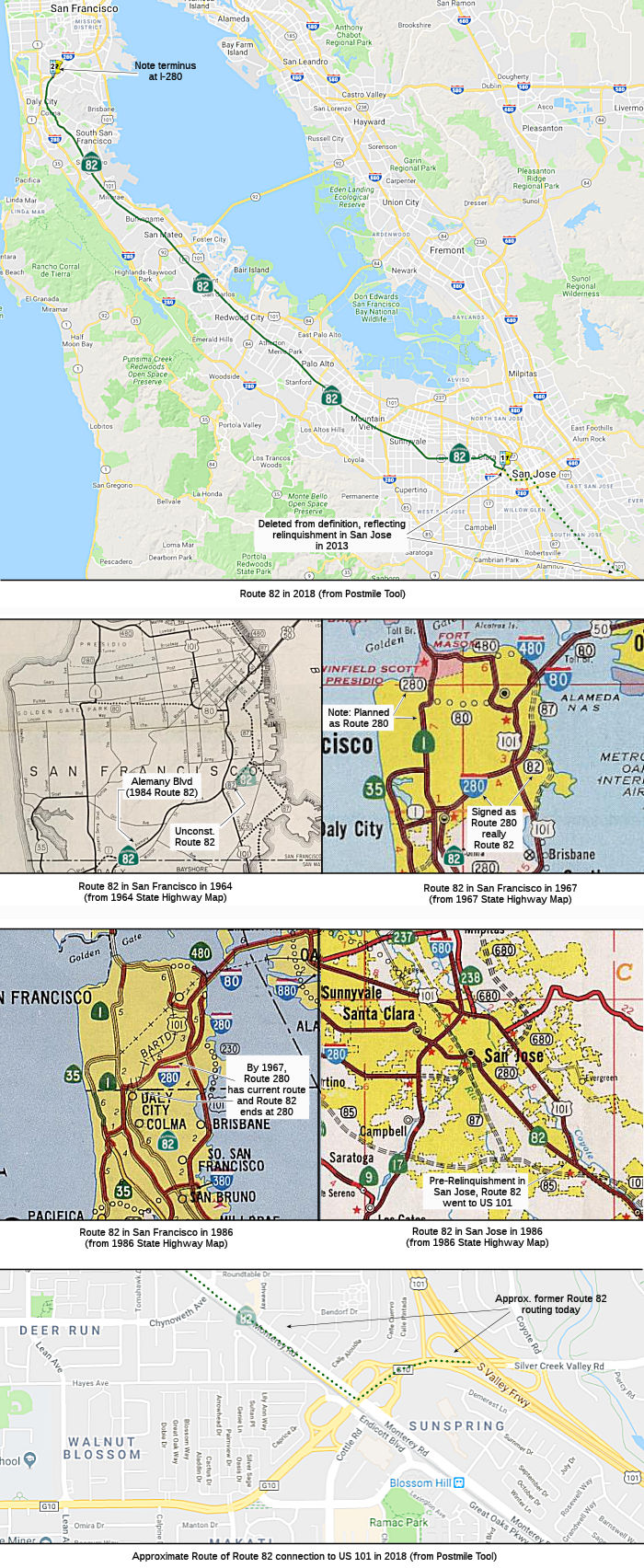 (a) From Route 880 in San Jose to Route 280 in San Francisco.
(b) The relinquished former portion of Route 82 within the City of San Jose is not a state highway and is not eligible for adoption under Section 81. For the relinquished former portion of Route 82, the City of San Jose shall maintain within its jurisdiction signs directing motorists to the continuation of Route 82 and shall ensure the continuity of traffic flow on the relinquished former portion of Route 82, including any traffic signal progression. The city may apply to the department for approval of a business route designation in accordance with Chapter 20, Topic 21, of the Highway Design Manual.
 Post 1964 Signage History
In 1963, this route was defined as "(a) Route 101 near Ford Road south of San Jose to Route 101 in San Francisco. (b) Route 101 near Alemany Boulevard to Route 87 in San Francisco." There also was the following condition: "Notwithstanding the provisions of Section 89 of Chapter 1062 of the Statutes of 1959, construction of all or any portion of subdivision (b) of Route 82 may be commenced at any time, if the City and County of San Francisco has conveyed or does convey to the State of California, without charge, all real property presently acquired by it for the construction of said subdivision (b) of this route or such portion thereof." This appeared to be a long-standing contention: that San Francisco must provide the land for the construction.
In 1968, Chapter 282 truncated the definition to "Route 101 near Ford Road south of San Jose to Route 280 in San Francisco." and transferred the condition to I-280. This chapter also transferred the portion from I-280 to US 101, as well as the entire part (b) routing, to I-280.
In 1988, Chapter 106 changed the origin to be "Route 101 near Blossom Hill Road in San Jose"
In 2010, Chapter 448 (AB 1670, 9/29/10) renumbered the routing as (a) and added subsection (b) covering the relinquishment from Route 101 to Route 880.
In December 2011, the CTC authorized relinquishment of right of way in the city of San Jose on Route 82 from Route 880 to Route 101 (near Blossom Hill Road), under terms and conditions determined to be in the best interest of the State, as stated in the relinquishment agreement scheduled to be approved by the City at their November 29, 2011 Council Meeting. Authorized by Chapter 448, Statutes of 2010, which amended Section 382 of the Streets and Highways Code.
In 2013, Chapter 525 (SB 788, 10/9/13) reworded the definition to reflect relinquishments:
(a) From Route 880
Route 101 near Blossom Hill Roadin San Jose to Route 280 in San Francisco.(b) The relinquished former portion of Route 82 within the City of San Jose is not a state highway and is not eligible for adoption under Section 81. For the relinquished former portion of Route 82, the City of San Jose shall maintain within its jurisdiction signs directing motorists to the continuation of Route 82 and shall ensure the continuity of traffic flow on the relinquished former portion of Route 82, including any traffic signal progression. The city may apply to the department for approval of a business route designation in accordance with Chapter 20, Topic 21, of the Highway Design Manual.
Upon a determination by the commission that it is in the best interests of the state to do so, the commission may, upon terms and conditions approved by it, relinquish to the City of San Jose the portion of Route 82 from Route 101 to Route 880 in that city if the department and the city enter into an agreement providing for that relinquishment. The following conditions shall apply upon relinquishment:(1) The relinquishment shall become effective on the date following the county recorder's recordation of the relinquishment resolution containing the commission's approval of the terms and conditions of the relinquishment.
(2) On and after the effective date of the relinquishment, the relinquished portion of Route 82 shall cease to be a state highway.
(3) The portion of Route 82 relinquished under this subdivision shall be ineligible for future adoption under Section 81.
(4) The City of San Jose shall ensure the continuity of traffic flow on the relinquished portion of Route 82, including any traffic signal progression.
(5) For the portion of Route 82 that is relinquished under this subdivision, the City of San Jose shall install and maintain within the jurisdiction of the city signs directing motorists to the continuation of Route 82 to the extent deemed necessary by the department.
 Pre 1964 Signage History
  This is the former surface routing of US 101; it was signed as
US 101 until the 1964 route realignment and the signing of Bypass US 101
as US 101. It was the original portion of LRN 2, defined in 1909. Note
that the route of current Route 82 in downtown San Jose differs from the
route of US 101 when it ran down the El Camino routing: instead of
continuing on West Santa Clara Street east to Market, Route 82 south turns
right at San Jose Arena onto Montgomery Street (northbound Route 82 uses
Montgomery to Autumn Street, then makes the left turn on West Santa Clara
at the arena). Route 82 southbound then uses San Carlos Street northeast
to reconnect with Market; this rerouting may have occured as a result of
the construction of the I-280/Route 87 interchange and occured several
years before San Jose Arena was finished.
This is the former surface routing of US 101; it was signed as
US 101 until the 1964 route realignment and the signing of Bypass US 101
as US 101. It was the original portion of LRN 2, defined in 1909. Note
that the route of current Route 82 in downtown San Jose differs from the
route of US 101 when it ran down the El Camino routing: instead of
continuing on West Santa Clara Street east to Market, Route 82 south turns
right at San Jose Arena onto Montgomery Street (northbound Route 82 uses
Montgomery to Autumn Street, then makes the left turn on West Santa Clara
at the arena). Route 82 southbound then uses San Carlos Street northeast
to reconnect with Market; this rerouting may have occured as a result of
the construction of the I-280/Route 87 interchange and occured several
years before San Jose Arena was finished.
According to Chris Sampang much of Old Mission Road is the original
alignment of US 101 and the El Camino Real which was bypassed in the
1930s. The original alignment of Old Mission Road bent back towards Route 82 over Colma Creek at one point.
(Source: Tom Fearer: Gribblenation Blog on Route 82, February 2019)
The Historic Aerials site permits closer examination of the intersection of Mission Road (former El Camino Real/US 101) and Oak Avenue, where the current road turns to the southeast to meet up with Chestnut Avenue. In 1946, the existing westerly routing crossing Colma Creek closer to Colma was already in existence, but Mission Road still returned to El Camino Real at its south end, about a thousand feet south of the current Chestnut/El Camino intersection. By 1956, Mission was widened in the South San Francisco portion, but truncated to Chestnut Avenue, crossing Colma Creek near where Mission and Oak presently intersect via the road that is now "Antoinette Lane." Some time between 1968 and 1980, the section of historic El Camino Real/US 101 along what is now Antoinette Lane between the creek and Chestnut Avenue was bypassed by the current, modern routing of Mission Road southeast of Oak Avenue, and truncated to not cross the creek.
 Route 82 was not defined as part of the initial state signage of
routes in 1934. It is unclear what (if any) route was signed as Route 82
between 1934 and 1964.
Route 82 was not defined as part of the initial state signage of
routes in 1934. It is unclear what (if any) route was signed as Route 82
between 1934 and 1964.
 Status
In October 2011, the CTC approved $11.2 million to install closed-circuit video cameras, vehicle detection systems and improved traffic signals along Route 82.
Former Route 82 (Former US 101) in San Jose
Monterey Highway - US 101 in Gilroy to San Jose
In February 2023, it was reported that a recent Federal bill has
allocated $2 million for the Monterey Road Highway to Grand Boulevard
Design Study in the city of San Jose, which will explore converting
Monterey Road (former Route 82, nee US 101) from a motor highway to a
grand boulevard. The project proposes to redesign Monterey Road -
currently a six-lane facility with 50 mph traffic - as "a complete street
that will prioritize safety and improve accessibility for individuals who
walk, bike, or use transit. Community engagement activities will bring
residents, community organizations, and transportation agencies together
to identify the most important transportation challenges and develop
strategies to overcome them. Potential project improvements to be
considered include dedicated transit lanes, protected bike lanes, urban
greening, and reconstructed intersections. Monterey Road, an important
transit corridor running through San Jose, has a deadly history in the
South Bay. Once part of the El Camino Real in 1700s, the 9.6-mile stretch
from Keyes Street to Metcalf Road has become increasingly dangerous in the
past few decades. The funding is part of the Reconnecting Communities
Pilot program through the U.S. Department of Transportation. The other
cities receiving funds are Oakland, Long Beach, Pasadena and Fresno. The
pilot program was established in the nation's Bipartisan Infrastructure
Law, which passed in 2021. City officials have worked on various piecemeal
solutions along Monterey Road and surrounding streets over the years. The
city spent roughly $1 million in 2022 on Senter Road, a nearby busy and
dangerous street, to paint the intersections and install plastic barriers
to slow down traffic, among other safety measures. San Jose also received
$10 million in state funding in August 2022 for more street lights, bike
lanes and other protective measures around Senter Road. Also in 2022 on
Monterey Road, San Jose installed pedestrian median fences, cameras and
other safety measures. City officials hope to upgrade damaged guardrails
along Monterey Road in Summer 2023.
(Source: Streetsblog LA, 2/28/2023; San Jose Spotlight, 3/2/2023)
No status updates.
In August 2011, it was reported that owners of more than 50% of the properties on The Alameda (in downtown San Jose, S of 880) have given verbal agreements to support the formation of a Maintenance Improvement District to fund a $4 million makeover of the segment. The makeover funding comes primarily from a Metropolitan Transportation Commission grant with some additional funding from the San Jose Department of Transportation. The grant was based on the vision offered of raised medians with landscaping and pedestrian refuges, new lighting, gateway and neighborhood markers, enhanced pedestrian crosswalks and corner sidewalk bulb-outs. It would stretch from Stockton Avenue down The Alameda to where it meets Fremont Street and Schiele Avenue.
San Jose / Santa Clara (I-880) to Mountain View (Route 85)
Mayfield Pedestrian UC Abandonment (04-SCl-82 PM R11.4/26.4)
In December 2021, the CTC approved amending the SHOPP
as follows: 04-SCl-82 PM R11.4/26.4. PPNO 04-2021B; Proj ID 0418000032; EA
0P980. Route 82 In the cities of Santa Clara and Palo Alto, at De La Cruz
Boulevard Overcrossing (OC) № 37-0214 (PM R11.38), Mayfield
Pedestrian Undercrossing (UC) № 37-0091 (PM 24.15), University
Avenue OC № 37-0092 (PM 25.88), and San Francisquito Creek Bridge
№ 37-0018 (PM 26.36). Upgrade bridge rails at three locations
and abandon the Mayfield Pedestrian UC. Note: Update
performance based on the latest available bridge data. Increase
construction capital due to additional bridge widenings to accomodate bike
and pedestrian accessability, increased cost for structural and roadway
items, and signal and lighting upgrades. Additional structural and
electrical work increased the number of contract working days, thus
increasing the construction support cost. Allocation changes ($1,000s):
Con Sup $1,031 ⇒ $1,350; Const Cap $1,922 ⇒ $6,202.
(Source: December 2021 CTC Agenda, Agenda Item
2.1a.(1d) #10)
In January 2022, the CTC approved the following SB1
support phase allocation: $1,859,000. 04-SCl-82 R11.4/26.4. PPNO 04-2021B;
ProjID 0418000032; EA 0P980. Route 82 In the cities of Santa Clara and
Palo Alto, at De La Cruz Boulevard Overcrossing (OC) № 37-0214 (PM
R11.38), Mayfield Pedestrian Undercrossing (UC) № 37-0091 (PM
24.15), University Avenue OC № 37-0092 (PM 25.88), and San
Francisquito Creek Bridge № 37-0018 (PM 26.36). Upgrade bridge rails
at three locations and abandon the Mayfield Pedestrian UC. Allocation:
PS&E $1,824,000 ($1,533,000 programmed); R/W Sup $35,000 ($30,000
programmed).
(Source: January 2022 CTC Agenda, Agenda Item
2.5b.(2b) #8)
In August 2023, the CTC approved the following SHOPP
Construction Phase allocation: $8,336,000. 04-SCl-82 R11.38/26.36. PPNO
04-2021B; ProjID 0418000032; EA 0P980. Route 82 In the cities of Santa
Clara and Palo Alto, at De La Cruz Boulevard Overcrossing Bridge №
37-0214 (PM R11.38), Mayfield Pedestrian Undercrossing Bridge №
37-0091 (PM 24.15), University Avenue Overcrossing Bridge № 37-0092
(PM 25.88), and San Francisquito Creek Bridge № 37-0018 (PM 26.36).
Outcome/Output: Upgrade bridge rails at three locations and abandon the
Mayfield Pedestrian Undercrossing Bridge to meet Federal crash test
standards and to increase safety for pedestrians and bicyclists using the
sidewalk or bike path. Preliminary Engineering (Budget / Expended):
PA&ED $638,000 / $637,492; PS&E $2,206,400 / $2,069,663;
R/W Sup $155,000 / $112,911. CEQA - CE, 12/20/2021;
Re-validation 6/23/2023. NEPA - CE, 12/20/2021; Re-validation 6/23/2023.
Four month allocation time extension for CONST and CON ENG approved under
Waiver 23-72; June 2023. Allocation (Programmed / Allocated):
CON ENG $1,350,000 / $1,485,000; CONST $6,202,000 / $6,851,000.
(Source: August 2023 CTC Agenda, Agenda Item 2.5b.(1) #22)
Grand Blvd Initiative (~ SCL 11.545 to SCL 21.604)
The SAFETEA-LU act, enacted in August 2005 as the
reauthorization of TEA-21, provided the following expenditures on or near
this route: High Priority Project #1942: El Camino Real Grand Blvd
initiative in San Mateo Santa Clara County. $3,000,000.
In August 2011, the San Francisco Chronicle reported on the Grand Boulevard Initiative. The Grand Boulevard Initiative is an ongoing effort to transform the street into "a destination of valued places," spur development and improve the pedestrian feel of a roadway that now varies in width from 129 feet in Millbrae to 46 feet in Burlingame, where the eucalyptus trees on either side are protected as part of the city's cultural heritage. Additional details may be found in the full article from the Chronicle.
![[Grand Initiative]](maps/082-grandinit.jpg) In October 2011, more information on the Grand Boulevard Initiative was published. The plan
includes removing two lanes of traffic from Lafayette Street in Santa
Clara to Showers Drive in Mountain View and turn them into bus-only lanes
running down the middle of the road. The express buses would be sleek and
look more like light-rail trains, with ticket areas in the median and
signals that turn green as a bus approaches an intersection. A 3-inch curb
would separate the bus lanes from cars, enough to alert motorists who may
wander into the transit-only lanes. The curbs would be low enough to allow
emergency vehicles access. For this initiative to be realized, the VTA
needs city councils in all six cities along El Camino within the county to
endorse the changes, in addition to approval from Caltrans (VTA will be
submitting the plan in June 2012) as El Camino is a state route. Money for
the project is coming from the ½¢ transit-only sales tax
approved in 2000 to bring BART to the South Bay and make other rail and
bus improvements. The VTA will also seek some federal funding. The El
Camino changes could cost $240 million, with $75 million possible from
Washington.
In October 2011, more information on the Grand Boulevard Initiative was published. The plan
includes removing two lanes of traffic from Lafayette Street in Santa
Clara to Showers Drive in Mountain View and turn them into bus-only lanes
running down the middle of the road. The express buses would be sleek and
look more like light-rail trains, with ticket areas in the median and
signals that turn green as a bus approaches an intersection. A 3-inch curb
would separate the bus lanes from cars, enough to alert motorists who may
wander into the transit-only lanes. The curbs would be low enough to allow
emergency vehicles access. For this initiative to be realized, the VTA
needs city councils in all six cities along El Camino within the county to
endorse the changes, in addition to approval from Caltrans (VTA will be
submitting the plan in June 2012) as El Camino is a state route. Money for
the project is coming from the ½¢ transit-only sales tax
approved in 2000 to bring BART to the South Bay and make other rail and
bus improvements. The VTA will also seek some federal funding. The El
Camino changes could cost $240 million, with $75 million possible from
Washington.
(Source: San Jose Mercury News, 10/23/2011)
In November 2018, it was reported that the VTA, Santa Clara and Mountain
View have big plans to overhaul El Camino over the next decade (~ SCL
18.924). Here is what is being considered:
(Source: Mercury News, 11/13/2018)
In October 2019, it was reported that the Mountain View City Council
unanimously approved an estimated $81 million improvement plan for El
Camino Real featuring protected bicycle lanes, wider sidewalks and three
new crosswalks with signals. Although the upgrades are expected to take
years to complete, the council’s decision marks the first step
toward making the safety improvements that elected officials and city
staff have spent years discussing. In 2014, the city of Mountain View
adopted a plan for El Camino that provided a road map for future changes
and investment to the boulevard. City staff subsequently began developing
a more detailed outline. Five years later, under the newly adopted plan,
on-street parking will be replaced with protected bike lanes, bus stops
will be updated to allow for the safety of cyclists and three new
mid-block crosswalks with signals will be constructed at Crestview Drive,
Bonita Avenue and Pettis Avenue. As for the remaining $40 million in
estimated costs, city staff said that Catrans will cover some as part of
its upcoming paving and ADA projects, the city will seek outside grants
and the remainder will be funded through the city’s capital
improvement program.
(Source: $$ Mercury News, 10/1/2019)
The 2020 SHOPP, approved in May 2020, included the following NEW Bridge
Restoration item of interest: 04-Santa Clara-82 PM R11.4/26.4 PPNO 2021B
Proj ID 0418000032 EA 0P980. Route 82 in the cities of Santa Clara and
Palo Alto, at De La Cruz Boulevard Overcrossing (OC) No. 37-0214 (PM
R11.38), Mayfield Pedestrian Undercrossing (UC) No. 37-0091 (PM 24.15),
University Avenue OC No. 37 -0092 (PM 25.88), and San Francisquito Creek
Bridge No. 37-0018 (PM 26.36). Upgrade bridge rails at three locations and
abandon the Mayfield Pedestrian UC in Palo Alto (PM 24.15).
Programmed in FY22-23, with construction scheduled to start in November
2023. Total project cost is $5,197K, with $1,965K being capital (const and
right of way) and $3,232K being support (engineering, environmental,
etc.).
(Source: 2020 Approved SHOPP a/o May 2020)
Palo Alto Bicycle Lanes (~ SCL 22.145 to SCL 26.36)
In July 2023, it was reported that Caltrans, which in
Fall 2023 will begin to repave the local portion of El Camino Real, is
looking at replacing parking spaces all along the Kings Highway with bike
lanes. Earlier in 2023, Caltrans provided to the city of Palo Alto its
tentative engineering plans for the new bike lanes, a proposal that
appeared to have taken both the city and its bike advocates by surprise.
When the Palo Alto Pedestrian and Bicycle Advisory Committee (PABAC)
reviewed the plans at its May meeting, numerous members demanded more
context for the decision, according to meeting minutes. Some questioned
the goals of the Caltrans project while others focused on specific details
such as the design of "sharrows" (markings that indicate a path is to be
shared by cars and bikes) and the impact that the new bike lanes would
have on the vehicle dwellers who make El Camino their home. The Caltrans
plan for El Camino bike lanes is rolling out just as Palo Alto is
preparing for its own improvements to the local bike network. In June
2023, the City Council approved a consulting contract to work on a new
bike master plan, which would update the 2012 roadmap that's guided the
suite of bike projects the city has completed over the past decade.
Consideration of bike facilities on El Camino Real was always planned to
be included in the plan update. Since receiving Caltrans' plans, city
officials have repeatedly sought further clarification from the state
agency as well as a formal proposal and information about a public process
that the agency plans to use to obtain community feedback. Caltrans, for
its part, sees El Camino bike lanes as one of its priority projects in the
Peninsula. The agency's 2022 planning document for District 4, which
includes the Peninsula, cites the prior effort by the four Peninsula
cities to identify a long-distance separated bikeway that connects the
cities and its conclusion that El Camino would be the preferred corridor.
If the Caltrans plan advances, it would effectively supersede local
planning efforts for bike improvements along and around El Camino. The
bike master plan update is expected to take between 18 months and two
years to complete, by which time El Camino bike lanes may already be
established.
(Source: The Almanac, 7/13/2023)
Atherton (Route 84) to San Mateo (N of Route 92)
Route 82 / Route 92 Interchange (~ SM 10.518)
In June 2010, it was reported that studies are
beginning to improve the El Camino Real (Route 82)/Route 92 interchange.
Officials from three local transit agencies are splitting a $450,000 study
that by the end of Summer 2011 should map out why cars move so slowly
through the area, and what can be done about it. The purpose of the study
is to figure out if there are any quick and easy fixes for operational
problems in the interchange. C/CAG, MTC and the county Transportation
Authority will each pay $150,000 to fund the study.
[Source: Oakland Tribune, 6/9/10]
In January 2011, results from the study were disclosed. Five options are being considered. The favored option includes converting the existing cloverleaf configuration to a “partial cloverleaf” configuration. This would require the elimination of two loop ramps and the construction of diagonal off-ramps. Cost for the work is expected to be up to $15 million and San Mateo is currently sitting on a $2.8 million grant from the federal government for the design and construction of the project. The city is also seeking about $5 million for the project from the Metropolitan Transportation Commission. The focused study also favored an option that calls for constructing partial cloverleafs at the interchange with the widening of Route 92 by one lane in each direction. The other three options include:
In February 2014, it was reported that the draft EIR for reconstruction of the El Camino Real/Route 92 interchanage was released for public comment. The current El Camino Real-Route 92 interchange is laid out in a full cloverleaf configuration, with four circular ramps guiding cars on and off the highway. The merging lanes are short and tricky to negotiate. Traffic on Route 92 often backs up as motorists slow down to exit or accommodate cars shifting from the onramp to the highway. Caltrans proposes dismantling two of the cloverleafs. The planned configuration would funnel vehicles leaving the highway to new three-way intersections with stoplights at El Camino Real. If the plan is approved in its current form, Caltrans expects to begin construction in 2017.
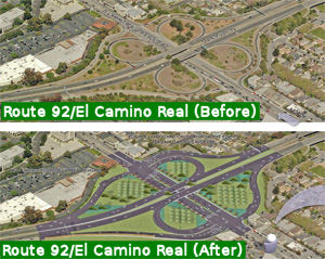 In March 2015, it was reported that after entering into a
cooperative agreement last year, the city of San Mateo and Caltrans are
collaborating on a $16 million reconfiguration of the on- and off-ramps
into a partial cloverleaf design. The project will also entail two
signalized intersections that will accommodate drivers entering El Camino
Real while also providing safer crossings for bicyclists and pedestrians.
San Mateo has assumed landscaping responsibilities after the completion of
the project on top of its $2.75 million contribution — the majority
of which came from a federal grant and San Mateo County Transportation
Authority Measure A fund. Caltrans is taking the lead on the project as it
has the in-house design staff. In the future, drivers entering Route 92
from El Camino Real will continue to have access to separate eastbound and
westbound on-ramps. Those exiting Route 92 will only have one off-ramp in
either direction that would eventually widen into two or three lanes at a
signalized intersection allowing drivers to turn either north or south
onto El Camino Real (Route 82). The project will add two additional
intersections with traffic lights between Bovet Road and 20th Avenue. The
current design is about 65% complete and Caltrans hopes to begin
construction in July 2016 with the project completed around April 2018.
In March 2015, it was reported that after entering into a
cooperative agreement last year, the city of San Mateo and Caltrans are
collaborating on a $16 million reconfiguration of the on- and off-ramps
into a partial cloverleaf design. The project will also entail two
signalized intersections that will accommodate drivers entering El Camino
Real while also providing safer crossings for bicyclists and pedestrians.
San Mateo has assumed landscaping responsibilities after the completion of
the project on top of its $2.75 million contribution — the majority
of which came from a federal grant and San Mateo County Transportation
Authority Measure A fund. Caltrans is taking the lead on the project as it
has the in-house design staff. In the future, drivers entering Route 92
from El Camino Real will continue to have access to separate eastbound and
westbound on-ramps. Those exiting Route 92 will only have one off-ramp in
either direction that would eventually widen into two or three lanes at a
signalized intersection allowing drivers to turn either north or south
onto El Camino Real (Route 82). The project will add two additional
intersections with traffic lights between Bovet Road and 20th Avenue. The
current design is about 65% complete and Caltrans hopes to begin
construction in July 2016 with the project completed around April 2018.
(Source: San Mateo Daily Journal, 3/7/2015)
In October 2015, it was reported that the San Mateo
County Transportation Authority allocated $16.2 million toward the project
that will convert the dangerous Route 92/El Camino Real Interchange into a
partial cloverleaf, realign the off- and on-ramps and add signalized
intersections on El Camino Real. The project will improve safety by
eliminating the short weave distance between drivers merging on and off
Route 92 as well as deter existing backups when drivers spill onto the
westbound portion of the highway at El Camino Real.
(Source: San Mateo Daily Journal, 10/2/2015)
In August 2016, the CTC approved a proposal from the Metropolitan Transportation Commission, the San Mateo City/County Council of Governments (C/CAG) and the San Mateo County Transportation Authority (SMCTA) to program an AB 3090 cash reimbursement project (PPNO 0668B) in order to use local funds for construction of the Route 92/Route 82 Interchange Improvements – Phase 1 project (PPNO 0668A) in San Mateo County. The San Mateo County Transportation Authority requested reimbursements over a two-year period beginning in Fiscal Year (FY) 2019-20. This project will reconstruct and reconfigure the existing interchange. Once completed, these improvements will result in increased operational efficiencies. SMCTA proposes to amend the STIP to revise the funding plan to advance project delivery with the use of $5,000,000 in local sales tax (Measure A) funds for construction support, and request reimbursements in FYs 2019-20 and 2020-21. This request follows AB 3090 Guidelines, which allow a local agency to use its own funds (non-state or non-federal) to complete a project component early to be later reimbursed with STIP funds currently programmed on the project.
In October 2016, the CTC approved the following STIP allocation: 04-SM-92 10.3/10.7; 11.0/11.5 | Route 92/Route 82 Interchange Improvements - Phase 1. In San Mateo. Modify existing on/off ramps at the Route 92/Route 82 interchange. It is proposed to remove the southeast and the northwest quadrant loops. Two new signalized intersections would be created at new on and off ramps on Route 82 (El Camino). $5,000,000
The Route 92/Route 82 interchange project in San Mateo was completed in early 2018, after several months in 2017 of realigning or removing the old ramps from the original cloverleaf.
San Mateo (N of Route 92) to San Francisco (Jct. I-280)
Floribunda Avenue Intersection Improvements / Burlingame (~ SM 13.683)
In December 2014, the CTC was provided the ability to comment on a draft EIR regarding a project in San Mateo County that will widen the intersection and install traffic signals on Route 82 at Floribunda Avenue in the city of Burlingame and the town of Hillsborough. The project is programmed in the 2014 State Highway Operation and Protection Program. The total estimated cost is $5,837,000 for capital and support. Construction is estimated to begin in Fiscal Year 2015-16. The scope, as described for the preferred alternative, is consistent with the project scope programmed by the Commission in the 2014 State Highway Operation and Protection Program. The decision to prepare an EIR was made due to a substantial amount of public controversy surrounding the project associated with the proposed removal of five historic trees. To mitigate this specific concernt, five replacement trees of an approved variety will be planted in the Halston-Ralston Eucalyptus Tree Rows along Route 82. Alternatives considered for the proposed project include:
In December 2019, the CTC had the following SHOPP
amendment on its agenda: 04-SM-82 13.7 PPNO 0686. Proj ID 0400002011
EA 1G020. On Route 82 Near Burlingame and Hillsborough city limits, at
the intersection of Route 82 and Floribunda Avenue. Install left turn
signal. Note: Delete project. An 18-month study period concluded
that the identified safety issue can be resolved by prohibiting the
left-turn movement at this intersection. There is no need to proceed
further with this project.
(Source: December 2019 CTC Agenda, Agenda Item
2.1a.(1d) Item 18)
 Naming
Historically, this route is close to the original "El Camino Real" (The Kings Road). This route has officially been designated as "El Camino Real by Assembly Bill 1769, Chapter 1569, in 1959.
 The segment of Route 82 between
Page Mill Road (SCL 24.04) and San Francisquito Creek (SCL 26.37/SM 0.000)
in the City of Palo Alto is named the "Betty Meltzer Memorial Highway"
This segment was named in memory of Elizabeth T. (Betty) Meltzer, best
known in Palo Alto for her environmental efforts, including being a key
organizer of the "Dream of a Thousand Trees for El Camino Real Project" in
Palo Alto, and cofounder with Ellen Wyman of Palo Alto Tomorrow, an
organization that successfully promoted sensible growth in downtown Palo
Alto. Betty Meltzer was born on May 3, 1939, in San Francisco to Anna Rose
and Sam Taylor, and moved to Palo Alto in 1948, where she graduated from
Palo Alto High School in 1956. Betty Meltzer graduated from Smith College
in 1960 and received her master's degree in education from Stanford
University in 1961. Beginning in the mid 1980's, Betty Meltzer began her
community organizing for a better Palo Alto with the cofounding of Palo
Alto Tomorrow. Betty Meltzer was also a graduate of the first class in
1987 of the "Leadership Palo Alto" (later "Leadership Midpeninsula")
program designed to train both citizens and government people on how to
contribute to local civic betterment. Betty Meltzer was an active member
in the Palo Alto Garden Club and the Palo Alto Women's Club. Meltzer
taught in the Palo Alto Unified School District for five years, trained
blind people how to read, and for many years tutored elementary school
students who had reading disabilities. Meltzer served on the board of the
former Peninsula Conservation Center Foundation (PCCF), now Acterra, and
was especially active in creating the Business Environmental Network,
which gave awards to environmentally outstanding businesses. Betty Meltzer
was cofounder with Susan Rosenberg of the Trees for El Camino Project
which aided the City of Palo Alto in obtaining the funding for hundreds of
new trees along the 4.3 miles of El Camino Real in Palo Alto. Betty
Meltzer, who was known for her tenacious attitude and steadfast commitment
to her work for the City of Palo Alto, was able to work with the
Department of Transportation to relax the department's regulations on the
planting of trees in road medians in order to realize her dream of seeing
Palo Alto's portion of El Camino Real become a welcoming, tree-lined
boulevard. Betty Meltzer died on September 29, 2008. Named by Senate
Concurrent Resolution (SCR) 30, Resolution Chapter 74, on 7/16/2009.
The segment of Route 82 between
Page Mill Road (SCL 24.04) and San Francisquito Creek (SCL 26.37/SM 0.000)
in the City of Palo Alto is named the "Betty Meltzer Memorial Highway"
This segment was named in memory of Elizabeth T. (Betty) Meltzer, best
known in Palo Alto for her environmental efforts, including being a key
organizer of the "Dream of a Thousand Trees for El Camino Real Project" in
Palo Alto, and cofounder with Ellen Wyman of Palo Alto Tomorrow, an
organization that successfully promoted sensible growth in downtown Palo
Alto. Betty Meltzer was born on May 3, 1939, in San Francisco to Anna Rose
and Sam Taylor, and moved to Palo Alto in 1948, where she graduated from
Palo Alto High School in 1956. Betty Meltzer graduated from Smith College
in 1960 and received her master's degree in education from Stanford
University in 1961. Beginning in the mid 1980's, Betty Meltzer began her
community organizing for a better Palo Alto with the cofounding of Palo
Alto Tomorrow. Betty Meltzer was also a graduate of the first class in
1987 of the "Leadership Palo Alto" (later "Leadership Midpeninsula")
program designed to train both citizens and government people on how to
contribute to local civic betterment. Betty Meltzer was an active member
in the Palo Alto Garden Club and the Palo Alto Women's Club. Meltzer
taught in the Palo Alto Unified School District for five years, trained
blind people how to read, and for many years tutored elementary school
students who had reading disabilities. Meltzer served on the board of the
former Peninsula Conservation Center Foundation (PCCF), now Acterra, and
was especially active in creating the Business Environmental Network,
which gave awards to environmentally outstanding businesses. Betty Meltzer
was cofounder with Susan Rosenberg of the Trees for El Camino Project
which aided the City of Palo Alto in obtaining the funding for hundreds of
new trees along the 4.3 miles of El Camino Real in Palo Alto. Betty
Meltzer, who was known for her tenacious attitude and steadfast commitment
to her work for the City of Palo Alto, was able to work with the
Department of Transportation to relax the department's regulations on the
planting of trees in road medians in order to realize her dream of seeing
Palo Alto's portion of El Camino Real become a welcoming, tree-lined
boulevard. Betty Meltzer died on September 29, 2008. Named by Senate
Concurrent Resolution (SCR) 30, Resolution Chapter 74, on 7/16/2009.
(Image source: Canopy Magazine, Spring 2010; Palo Alto Online)
 Other WWW Links
 National Trails
 This route is part of the De Anza National Historic Trail.
 Statistics
Overall statistics for Route 82:
 Pre-1964 Legislative Route
LRN 82 was first defined in 1933 as the route from "Etna Mills to Montague". In 1935, it was codified into the highway code as that routing.
In 1959, Chapter 1062 changed the origin to "[LRN 20] near Weaverville".
This is present-day Route 3; it is unclear how this was signed before 1964 — it may have been part of Route 36.
© 1996-2020 Daniel P. Faigin.
Maintained by: Daniel P. Faigin
<webmaster@cahighways.org>.
 Route 81
 Route 83