
 California Highways:
Click here for a key to the symbols used. An explanation of acronyms may be found at the bottom of the page.
 Routing
 Post 1964 Signage History
 Pre 1964 Signage History
This route was not a pre-1963 LRN.
 Status
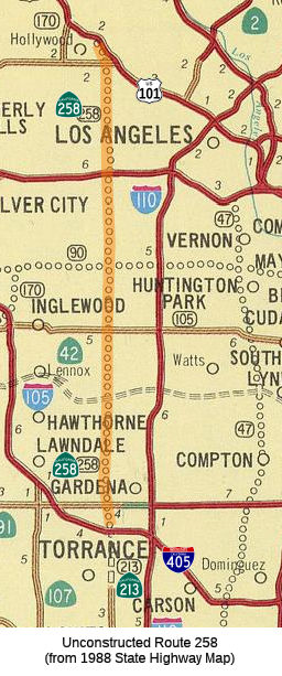
This routing was planned as freeway. It looks to break off US 101 near Cahuenga, then run along Normandie or Western until it reaches Route 405, when it becomes Route 213. It was never upgraded.
According to the 2013 Traversable Highways report, the route concept report recommends revised proposed alignment ~ 3.5 miles westerly and that description be : "from Route 405 near LAX, to Route 101 near Hollywood.". The nearest route is Western Avenue.
Whitnall Parkway
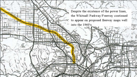 Some maps show the Route 258 freeway connecting to the
Whitnall Freeway from the valley. This is due to the confusion between the
proposal for the Whitnall Freeway (which was Route 64), and an
earlier, 1927 proposal for a Whitnall Parkway that remained on
planning maps until the 1960s. The figure to the right shows the Whitnall
Parkway approach; a 2014 LA Times article used words that made this appear
to be the freeway proposal from the 1960s (it clearly isn't, as the Route 64 freeway ran across Chase and Malibu Canyon, and the Route 258 freeway
ran along Normandie). This approach connects to Route 258, along what is
now "Whitnall Highway" in Burbank (which could be the source of the naming
of this route). It does not appear substantiated in the route definitions,
so this doesn't appear to be a highway at the state level. Gordon Whitnall
was involved in city planning around 1916. Whitnall's vision for Los
Angeles was both practical and idealistic. He believed that Los Angeles'
geographical location made it predestined to be the most important city in
the West. He also saw that Los Angeles was not just L.A. proper, but the
numerous other satellite cities that surrounded it. These contiguous
cities suffered from poor transportation and scattered administrative
centers. Quickly promoted to Director of City and County Planning, he
envisioned a sprawling metropolis made up of numerous organic civic
districts, linked together by a series of arterial highways, and unified
by a centrally located administrative and government center downtown near
the historic Plaza, where it would be "accessible to all." Whitnall and
the planning committee also envisioned four "highways" that would radiate
from the valley into arteries leading to the city. These parkway/highways
were more modest in design from the modern freeway, and often featured a
landscaped center strip separating opposing lanes of traffic. They were
Balboa Boulevard, San Fernando Boulevard, Remsen Boulevard (seemingly
never built), and most ambitious of all -- Whitnall Highway. Whitnall
Highway would stretch diagonally southeast by northwest from Newhall (now
part of Santa Clarita) through the San Fernando Valley, and meet up with
the entrance of a two-mile tunnel originating off Riverside Drive (which
was being expanded into a major artery linking the valley to downtown)
that would run under Griffith Park into Hollywood, via Bronson Avenue. Had
this tunnel been built it would be the longest highway tunnel in
California, and even today would rank as the third longest highway tunnel
in the USA. On June 5, 1927, the first section of Whitnall Highway opened
to a crowd of 300 at the intersection of Whitnall and Cahuenga Boulevard.
Gordon, the guest of honor, christened the highway at the ceremony, which
also celebrated the opening of 400 residential tracts owned by the Hugh
Evans Corporation. Homeowners in the projected path of the highway began
to protest the city's attempt to enforce its right of way through their
property. The road was extended, despite further protests, to Oxnard
Boulevard in 1931. Yet, after 1934, both plans for the highway and the
tunnel abruptly disappeared from the news, though variations continued to
appear on maps of proposed transit routes. Over the years, Burbank and
North Hollywood tried to figure out what to do with the quirky wide road,
and all the free public space below the giant transmission towers which
loomed overhead. Portions of the land were used as makeshift playgrounds,
parks, and bike trails, but by 1973 the city of Burbank was at a loss. The
community seemed to have little interest in pushing for landscaping, or
the creation of public parks, and the city had a hard time commercially
leasing the land, since nothing permanent could be built under the
structures. In 1989 a group of mentally challenged people created a garden
on 21 miles under the power lines. In the '90s Burbank finally
commissioned the Whitnall Highway Parks North and South.
Some maps show the Route 258 freeway connecting to the
Whitnall Freeway from the valley. This is due to the confusion between the
proposal for the Whitnall Freeway (which was Route 64), and an
earlier, 1927 proposal for a Whitnall Parkway that remained on
planning maps until the 1960s. The figure to the right shows the Whitnall
Parkway approach; a 2014 LA Times article used words that made this appear
to be the freeway proposal from the 1960s (it clearly isn't, as the Route 64 freeway ran across Chase and Malibu Canyon, and the Route 258 freeway
ran along Normandie). This approach connects to Route 258, along what is
now "Whitnall Highway" in Burbank (which could be the source of the naming
of this route). It does not appear substantiated in the route definitions,
so this doesn't appear to be a highway at the state level. Gordon Whitnall
was involved in city planning around 1916. Whitnall's vision for Los
Angeles was both practical and idealistic. He believed that Los Angeles'
geographical location made it predestined to be the most important city in
the West. He also saw that Los Angeles was not just L.A. proper, but the
numerous other satellite cities that surrounded it. These contiguous
cities suffered from poor transportation and scattered administrative
centers. Quickly promoted to Director of City and County Planning, he
envisioned a sprawling metropolis made up of numerous organic civic
districts, linked together by a series of arterial highways, and unified
by a centrally located administrative and government center downtown near
the historic Plaza, where it would be "accessible to all." Whitnall and
the planning committee also envisioned four "highways" that would radiate
from the valley into arteries leading to the city. These parkway/highways
were more modest in design from the modern freeway, and often featured a
landscaped center strip separating opposing lanes of traffic. They were
Balboa Boulevard, San Fernando Boulevard, Remsen Boulevard (seemingly
never built), and most ambitious of all -- Whitnall Highway. Whitnall
Highway would stretch diagonally southeast by northwest from Newhall (now
part of Santa Clarita) through the San Fernando Valley, and meet up with
the entrance of a two-mile tunnel originating off Riverside Drive (which
was being expanded into a major artery linking the valley to downtown)
that would run under Griffith Park into Hollywood, via Bronson Avenue. Had
this tunnel been built it would be the longest highway tunnel in
California, and even today would rank as the third longest highway tunnel
in the USA. On June 5, 1927, the first section of Whitnall Highway opened
to a crowd of 300 at the intersection of Whitnall and Cahuenga Boulevard.
Gordon, the guest of honor, christened the highway at the ceremony, which
also celebrated the opening of 400 residential tracts owned by the Hugh
Evans Corporation. Homeowners in the projected path of the highway began
to protest the city's attempt to enforce its right of way through their
property. The road was extended, despite further protests, to Oxnard
Boulevard in 1931. Yet, after 1934, both plans for the highway and the
tunnel abruptly disappeared from the news, though variations continued to
appear on maps of proposed transit routes. Over the years, Burbank and
North Hollywood tried to figure out what to do with the quirky wide road,
and all the free public space below the giant transmission towers which
loomed overhead. Portions of the land were used as makeshift playgrounds,
parks, and bike trails, but by 1973 the city of Burbank was at a loss. The
community seemed to have little interest in pushing for landscaping, or
the creation of public parks, and the city had a hard time commercially
leasing the land, since nothing permanent could be built under the
structures. In 1989 a group of mentally challenged people created a garden
on 21 miles under the power lines. In the '90s Burbank finally
commissioned the Whitnall Highway Parks North and South.
(Source: LA Times, 10/28/2014; KCETLost
Landmarks, 6/28/2013; Jayne Vidheecharoen/Slideshare, 4/18/2011)
 A late 1940s parkway plan shows the Whitnall Parkway in a bit more detail.
This image, from the 1948 publication Street Traffic Management for Los Angeles, shows the freeway / parkway plan that had been in the works during the 1940s (at least from
the city's perspective). It had the Whitnall Parkway following much of the
rail line across the San Fernando Valley and seemingly into Simi Valley.
At the Southeastern end, the Whitnall Parkway connected to the Normandie
Parkway (which provides some explanation for why Route 258 was also
considered part of the Whitnall Freeway).
A late 1940s parkway plan shows the Whitnall Parkway in a bit more detail.
This image, from the 1948 publication Street Traffic Management for Los Angeles, shows the freeway / parkway plan that had been in the works during the 1940s (at least from
the city's perspective). It had the Whitnall Parkway following much of the
rail line across the San Fernando Valley and seemingly into Simi Valley.
At the Southeastern end, the Whitnall Parkway connected to the Normandie
Parkway (which provides some explanation for why Route 258 was also
considered part of the Whitnall Freeway).
(Source: LA Metro Primary Resources, "Past Visions of Los Angeles’ Transportation Future: 1940s", retrieved 12/23/2023)
Earlier maps show it skirting the
Western edge of Griffith Park, connecting with Whitnall Highway in
Burbank, and eventually connecting with Route 64, the Whitnall Freeway.
According to Caltrans, the traversable route is Western Avenue, with
Caltrans having no plans to assume maintenance. The freeway routing was
never determined. The route concept report recommends that the alignment
be moved 3.5 mi westerly, and the definition be from Route 405 near LAX to
Route 101 near Hollywood.
(Map Source: LA Times, 10/28/2014. Note that this shows a different routing of Route 64
than some other maps, which have it terminating at the I-5/Route 64
junction. It could reflect different planning options over different
times.)
 Naming
Maps based on the 1956 freeway plan identify this route as a portion of the "Whitnall" freeway (Route 64). It appears to have continued N from US 101 to loop up near Olive and Alameda in Burbank to join up with the remainder of the Whitnall Freeway near Chase.
The Whitnall Freeway was named for Gordon Whitnall, the former Los Angeles city director of
planning. Part of the reason for the naming could be that the route ran
along Whitnall Highway, an unusual divided street that was laid
out in 1927 to be part of a parkway network envisioned to dissect the
Valley. In 1913, Gordon Whitnall founded the Los Angeles City Planning
Association, and in 1920, he established the Los Angeles City Planning
Department. From 1920-1930, he was Director of Planning for Los Angeles,
and from 1929-1930 was president of the League of California Cities. From
1932-1935 he was the coordinator of the Committee on Government
Simplification for Los Angeles County. In 1941, Gordon and Brysis Whitnall
established a planning and government consulting firm in Los Angeles.
Gordon Whitnall was an instructor in Planning at the University of
Southern California, and a member of the American Society of Planning
Officials, the American Institute of Planners, the American Society of
Consulting Planners, and the International Fraternity of Lambda Alpha, Los
Angeles Chapter.
(Source: Gordon and Brysis Whitnall papers, 1913-1975)
StatusThis routing is currently unsigned.
 Freeway
[SHC 253.1] Entire route. Added to the Freeway and Expressway system in 1965.
 Statistics
Overall statistics for Route 258:
 Pre-1964 Legislative Route
In 1959, Chapter 1062 defined LRN 258 as:
This route was signed as follows:
© 1996-2020 Daniel P. Faigin.
Maintained by: Daniel P. Faigin
<webmaster@cahighways.org>.
 From Route
  Route 257
 Route 259