
 California Highways:
Click here for a key to the symbols used. An explanation of acronyms may be found at the bottom of the page.
 Routing
 Post 1964 Signage History
In 1963, this route was defined as “Route 5 to Route 99 north of the Calaveras River.”
In 1990, Chapter 1187 clarified the terminus: “…to Route 99 north of the Calaveras River in Stockton.”
 Pre 1964 Signage History
This route was proposed LRN 260, defined in 1959.
Tom Fearer notes: "The planned route of LRN 260 first appears on the 1960
State Highway City Insert and is shown north of Stockton intersecting
Lower Sacramento Street and Thorton Street heading west from US 99/US 50/LRN 4 to LRN 238 (future I-5). When LRN 260 was initially designated it
wasn't long before Signed County Sign Route J8 had been applied over Hammer Lane west
from US 99/US 50 to Thorton Street in 1960. County Sign Route J8 continued northward onto
a terminus in south Sacramento. At the time LRN 260 and County Sign Route J8 had been
created Hammer Lane only existed west from US 99 to Thorton Street. By the
1964 State Highway Renumbering LRN 260 had been re-designated as part of
the future Route 235."
(Source: Gribblenation Blog (Tom Fearer): Un-constructed California State Route 235)
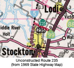
 Status
This routing is unconstructed. The traversable route is Eight Mile Road according to one Caltrans document, but according to a Caltrans map, it may be Hammer lane J-8. The county is placing the road into a state of good repair. In 1983, San Joaquin County passed resolution R-83-1461 for procedures to be followed to include French Camp Road in the state highway system as Route 234 and Eight-Mile Road as Route 235. On November 29, 1993, San Joaquin County adopted Eight-Mile Road as an arterial highway and dropped interest in it as a state highway. Caltrans has no plans to assume maintenance of the traversable route. There is no schedule for Caltrans to assume maintenance.
According to the 2013 Traversable Highways report, this is Eight Mile Road. County arterial, no further plans.
 Freeway
[SHC 253.1] Entire route. Added to the Freeway and Expressway system in 1959.
 Statistics
Overall statistics for Route 235:
 Other WWW Links
 Pre-1964 Legislative Route
In 1953, Chapter 1787 defined LRN 233 as:
In 1957, Chapter 52 renumbered this definition as LRN 235.
In 1957, Chapter 1911 rewrote the definition of (a): "(a) A connection with [LRN 69] near 42d Avenue to a connection with [LRN 5] near High Street in Oakland"
In 1959, Chapter 1062 extended the route again by adding (c): “[LRN 75] near Lafayette to [LRN 75], described in Section 375(a), near Concord”
This route was signed as follows:
This is part of Route 77.
This appears to correspond to a proposed route for Route 77 between I-580 and Route 4. It appears to have run along 13th Avenue and Park Blvd, along Skyline Road, and Morago Road into Lafayette.
This also appears to be no longer part of the state highway system; it appears to have run along Pleasant Hill Road and Taylor Blvd.
© 1996-2020 Daniel P. Faigin.
Maintained by: Daniel P. Faigin
<webmaster@cahighways.org>.
 FromRoute
  Route 234
 Route 236