
 California Highways:
Click here for a key to the symbols used. An explanation of acronyms may be found at the bottom of the page.
 Routing
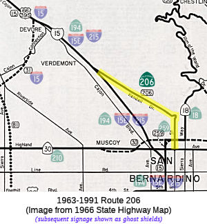 No current routing.
 Post 1964 Signage History
 In 1963, this route was defined as "Route 30 in San Bernardino via
Little Mountain to Route 15 near Verdemont."
In 1976, Chapter 1354 reworded the route and changed "Route 15" to "Route 194": "Route 194 to Route 30 in San Bernardino."
In 1982, Chapter 681 changed the order back to 1963, and changed "Route 194" to "Route 215": "Route 30 in San Bernardino via Little Mountain to Route 215 near Verdemont"
This routing was deleted in 1991 per AB 1886, Chapter 928. This was to have been a connector between a freeway portion of Route 30 (now Route 210) and I-15.
 Pre 1964 Signage History
The 1964-1991 definition of Route 206 was LRN 191. LRN was defined in 1933 as ""LRN 31 (US 395) near Verdemont to Highland Avenue, San Bernardino via Little Mountain.". It was not signed in the 1934 signage of state routes. It ran along Kendall Drive and E Street.
In November 1955, it was reported that during improvements to Cajon Pass,
LRN 191 was signed as US 66 Alternate (in reality US 66 Business).
The US 66 Business Loop followed LRN 191 on Kendall Drive and E Street to
Highland Avenue. From Highland Avenue the US 66 Business Loop
followed Route 18 via E Street and 5th Street back to mainline US 66
through downtown San Bernardino. The original US 66 Business Loop in
San Bernardino is unique in that it was chosen to follow an alignment
which never part of mainline US 66. A 1951 article noted that the I
Street Overhead was to carry Route 18 and US 66 Business via LRN 9 over
what had been previous an at-grade crossing of the Atchison, Topeka &
Santa Fe Railway (ATSF) mainline through San Bernardino. Prior to
the opening of the I Street Overhead, both Route 18 and US 66 Alternate
were aligned on 3rd Street. Signage may go back to the 1940s -- see the
discussion with US 66.
(Source: Gribblenation Blog (Tom Fearer), "Former California State Route 206 and the original US Route 66 Business Loop in San Bernardino", July 2022)
The Division of Highways submitted a request on May 13, 1958, to create a
new US 66-US 91-US 395 Business Loop in San Bernardino due to the
construction of I-15. The new US 66 Business Loop followed Mount
Vernon Avenue and 5th Street in San Bernardino via the original surface
routing of the highway. The request by the Division of Highways also
sought to eliminate the existing US 66 Business Loop on LRN 191, Kendall
Drive, E Street and 5th Street. The AASHO approved the Division of
Highways request on June 26, 1958, which eliminated the US 66 Business
Loop on LRN 191.
(Source: Gribblenation Blog (Tom Fearer), "Former California State Route 206 and the original US Route 66 Business Loop in San Bernardino", July 2022)
 Other WWW Links
 Pre-1964 Legislative Route
In 1935, the route “From [LRN 69] to [LRN 75] via Ashby Avenue” was added to the highway system by Chapter 630, with no number. In 1937, Chapter 841 deleted that definition, and redefined the route as:
"[LRN 69], the East Shore Highway, to [LRN 75] via Ashby Avenue, including that portion of the San Francisco-Oakland Bay Bridge approaches (on the Alameda County end) not included in [LRN 5] and [LRN 69]"
In 1959, Chapter 1062 extended the route to [LRN 257], and eliminated the specific language on the Bay Bridge: "[LRN 257] near Emeryville to [LRN 75] near Lake Temescal"
This route ran from proposed Route 61 near Emeryville to Route 24 near Lake Temescal. This is part of present-day Route 13, but the portion between I-80 (former US 40) and Route 24 was originally signed as Route 24.
© 1996-2020 Daniel P. Faigin.
Maintained by: Daniel P. Faigin
<webmaster@cahighways.org>.
 Route 205
 Route 207