
 California Highways:
Click here for a key to the symbols used. An explanation of acronyms may be found at the bottom of the page.
 Routing
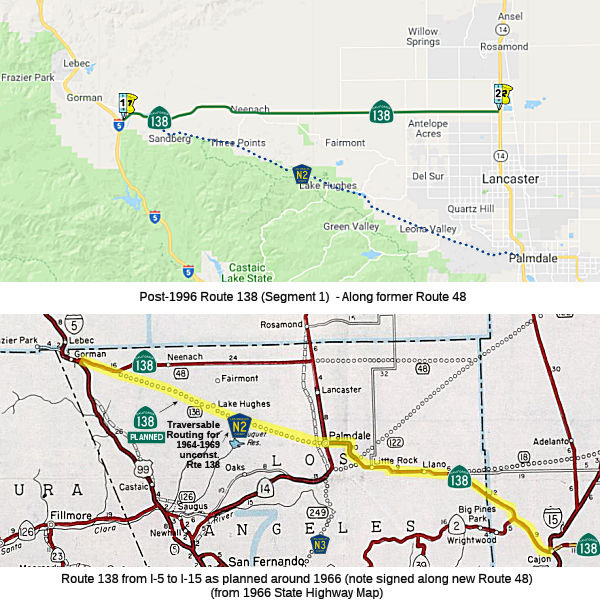 From Route 5 near Gorman to Route 14 near Lancaster.
 Post 1964 Signage History
In 1963, this segment was defined as "(a) Route 5 near Gorman to Route 15 near Cajon Pass." This was preparation for the "Metropolitan Bypass".
This was along the new alignment of LRN 59 that legislatively defined
running along what is modern Los Angeles County Sign Route N2 from Route 138 at Quail
Lake southeast to Palmdale. Route 138/LRN 59 from Quail Lake east to US 6/LRN 23 was given a new LRN 267 designation. During the 1964 Highway
renumbering the proposed route of LRN 59 between Quail Lake and Palmdale
was assigned to Route 138. LRN 267 to the north was assigned as part of
Route 48. By 1967, the path of Route 138 was eventually moved to a new
freeway/expressway alignment which bypassed the Old Ridge Route alignment
on Gorman Post Road. Eventually there were plans to route Route 138 along
Signed County Route N2
(Source: Gribblenation Blog - California State Route 138)
 In 1977, the CHC published that it was considering unadoption of the 71 mi segment
of the adopted freeway corridor on Route 138, the "Metropolitan Bypass
Freeway", from 1.5 mi E of I-5 to the San Bernardino County Line. This
corridor was adopted in 1966.
In 1977, the CHC published that it was considering unadoption of the 71 mi segment
of the adopted freeway corridor on Route 138, the "Metropolitan Bypass
Freeway", from 1.5 mi E of I-5 to the San Bernardino County Line. This
corridor was adopted in 1966.
(Source: Published Announcement, 1977, via Joel Windmiller,
2/25/2023)
In 1984, Chapter 409 combined the two segments to make this a continuous route: "Route 5 near Gorman to Route 18 near Crestline."
In 1996, Chapter 10 moved the route onto the former Route 48 routing, which created the need for a discontinuity again: "(a) Route 5 near Gorman to Route 14 near Lancaster. (b) Route 14 near Palmdale to Route 18 near Crestline." This reflected the deletion of a portion of former Route 48 to Route 14 near Palmdale, and the transfer of the portion of Route 48 from Route 138 to Route 14 near Lancaster. There is a 16 mile unconstructed, but adopted portion from Route 138 to Route 14, parallel to the existing traversable route, for the proposed freeway routing. That existing traversable routing for the pre-1996 Route 138 is Los Angeles County Sign Route N2. There may be some postmiles near Neenach that still show the pre-1995 designation of this as Route 48.
 Pre 1964 Signage History
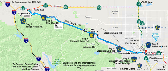 In 1919, the third highway bond act established a state highway between
Bailey's and Lancaster. It was an E-W routing from near Gorman to N of
Lancaster, passing through Neenach. It was LRN 59, and was signed as Route 138 after 1934. "Bailey's" likely refers to the Bailey Ranch land, which
was near Quail Lake (see this page on the Kinsey Ranch for a map). The Bailey Range was nearly 10,000 acres. According to the Ridge Route Museum, "In 1907 the Bailey family was “washed out” of their farm down near the present Pyramid Lake so they moved
their beautiful two-story ranch house, with the help of two mules and a
winch, in between Crane and Quail Lakes . The new location of the Bailey
Ranch became a roadside rest stop for travelers through the area." This is
likely the explanation of the reference to "Bailey's". It would correspond
to where the Ridge Route is.
In 1919, the third highway bond act established a state highway between
Bailey's and Lancaster. It was an E-W routing from near Gorman to N of
Lancaster, passing through Neenach. It was LRN 59, and was signed as Route 138 after 1934. "Bailey's" likely refers to the Bailey Ranch land, which
was near Quail Lake (see this page on the Kinsey Ranch for a map). The Bailey Range was nearly 10,000 acres. According to the Ridge Route Museum, "In 1907 the Bailey family was “washed out” of their farm down near the present Pyramid Lake so they moved
their beautiful two-story ranch house, with the help of two mules and a
winch, in between Crane and Quail Lakes . The new location of the Bailey
Ranch became a roadside rest stop for travelers through the area." This is
likely the explanation of the reference to "Bailey's". It would correspond
to where the Ridge Route is.
Note that, given the above, the short portion of Route 138 between I-5 and the old Ridge Route was original LRN 4. This became part of LRN 59, and thus Route 138. when US 99 was routed from the original Ridge Route to the Ridge Route Alternative through Pyramid Lake in 1933. Note that, in 1935, a segment was added to LRN 59 that was [LRN 4] near Gorman to Bailey's.
After 1959, a new routing for LRN 59 from about 10 mi E of Gorman through Lake Hughes directly to Palmdale was defined for Route 138 ("Metropolitan Bypass"), and the older routing from that point to Lancaster was renumbered LRN 267 (and eventually became part of LA County County Sign Route N2). Post 1964, the LRN 267 routing was renumbered as legislative Route 48, although it was signed as Route 138 (presumably, that signage would move once the bypass was completed). However, in 1996, the Route 138 to Lancaster portion of Route 48 was returned to Route 138, essentially restoring Route 138 back to the LRN 59 routing. Former LRN 267 at that point became County Sign Route N2.
In 1931, LRN 59 was extended between Lancaster and LRN 31 near Cajon Junction (US 66, what is now I-15).
In 1934, Route 138 was signed along the route from Jct. US 99 at Gorman to Jct. US 66 at Cajon, via Lancaster.
The original 1934 route of Route 138 from Gorman to Lancaster used the
following route:
(Source: Gribblenation Blog - California State Route 138)
By 1956 Route 138/LRN 59 had shifted onto Avenue D east from Neenach to
US 6/LRN 23 north of Lancaster.
(Source: Gribblenation Blog - California State Route 138)
 Status
Northwest 138 Corridor Project
 In March 2014, it was reported that Caltrans has started studies on the Northwest 138 Corridor
Project, which will expand on the previous North County combined Highway
Corridor Study completed in 2004 to develop a multi-modal transportation
plan for the northern portion of Los Angeles County to address both short
and long-term needs for a variety of trip purposes and goods movement.
This project is designed to cooperate with the High Desert Corridor
project that will provide a connection between Route 14 and Route 138 in
San Bernardino County. The Northwest 138 Corridor Project has an
information page at http://www.metro.net/projects/nw138/.
In March 2014, it was reported that Caltrans has started studies on the Northwest 138 Corridor
Project, which will expand on the previous North County combined Highway
Corridor Study completed in 2004 to develop a multi-modal transportation
plan for the northern portion of Los Angeles County to address both short
and long-term needs for a variety of trip purposes and goods movement.
This project is designed to cooperate with the High Desert Corridor
project that will provide a connection between Route 14 and Route 138 in
San Bernardino County. The Northwest 138 Corridor Project has an
information page at http://www.metro.net/projects/nw138/.
In July 2017, Caltrans reported that the final environmental impact statement/report had been released for public review for the Route 138 project between I-5 and Route 14. The two alternatives studied seek to make Route 138 safer between the I-5 and Route 14 in the northern part of Los Angeles County — in particular by improving sight lines and bringing the highly-trafficked road up to modern standards. Under the “Locally Preferred Alternative” in the FEIS/R, Route 138 would be:
This alternative would also improve the I-5/Route 138 and Route 138/Route 14 junctions and improve the Route 138 bridge that crosses the Route 14 freeway. Access along the corridor would be provided by at ‐ grade intersections with the exception of a tight diamond interchange at Gorman Post Road. Between Gorman Post Road and Route 14, all existing intersections with major roadways would be modified to restrict access to higher traffic roadways in order to improve safety and operations of the facility. Additional intersection treatment options considered and determined to be feasible include displaced left‐turns with median U‐turns, roundabouts, and jug‐handles. The decision on the actual intersection treatment will be determined during the final design phase. There would also be improvements to the I‐5/Route 138 and Route 138/Route 14 freeway connections and to the structure that crosses over Route 14.
The main corridor proposed for the preferred
alternative extends generally along or near the existing Route 138 highway
for approximately 36 miles from I-5 to Route 14. Portions of Route 138 not
used for the proposed improvements would remain and serve as a local
access road only. Three alternatives were studied as part of the FEIS/R: a
no-build alternative, Alternative 1 (freeway/expressway + Antelope Acres
Variation Option) and Alternative 2, which is the preferred alternative as
it would best meet the project’s purpose and need.
(Source: Metro "The Source", 7/10/2017; Project FEIR)
In November 2018, it was reported that Los Angeles
County Metropolitan Transportation Authority and Caltrans officials are
studying widening the two-lane Route 138 into a six-lane freeway for about
eight miles east of I-5 to 300th Street West, then a four-lane expressway
the remaining 28 miles from 300th Street West to the Antelope Valley
Freeway (Route 14). According to the Association of Rural Town Councils,
the expansion of Route 138 is directly tied to the Centennial project.
Proposed on about 12,300 acres along Route 138 west of 300th Street West,
Centennial calls for 19,333 homes on the 150-year-old Tejon Ranch at the
far reaches of the northwestern Antelope Valley. The population will be an
estimated 57,000 at full build-out, which is expected to take more than 20
years. Plans also call for 10 million square feet of business park,
retail, commercial, light industrial, civic and medical buildings. That
would also be brought on in proportion to the construction of homes. More
than 5,100 acres of the 12,300 acres will remain as natural grassland or
oak woodlands, with hundreds more acres in parks and other open
space, according to an environmental impact report prepared for Los
Angeles County. The project is expected to create 23,000 permanent jobs
and 25,000 jobs during construction. Centennial would generate $31.3
million in taxes and fees annually for Los Angeles County. The ARTC
believes that 10% of the project can be accommodated by the existing
conditions on Route 138, according to the DEIR. From 10% to 75% depends on
the expansion of Route 138 to six lanes to 300th Street West. Beyond that,
the project depends on an additional lane on each side that was not
anticipated by Caltrans or the Three Points Town Council.
(Source: AV Press, 11/5/2018)
60th Street West Roundabout (07-LA-138 PM 33.0/33.2)
The 2020 SHOPP, approved in May 2020, included the
following Collision Reduction item of interest (carried over from the 2018
SHOPP): 07-LA-138 PM 33.0/33.2 PPNO 5573 Proj ID 0719000171 EA 36490.
Route 138 near Lancaster, at the intersection with 60th Street West.
Construct roundabout. Programmed in FY23-24, with construction scheduled
to start in October 2024. Total project cost is $12,900K, with $6,680K
being capital (const and right of way) and $6,220K being support
(engineering, environmental, etc.). This was also amended into the 2018
SHOPP at the same meeting.
(Source: 2020 Approved SHOPP a/o May 2020; May 2020
CTC Agenda, Agenda Item 2.1a.(1a) #28)
In May 2020, the CTC approved the following support
allocation: 07-LA-138 33.0/33.2. PPNO 5573 ProjID 0719000171 EA
36490. Route 138 Near Lancaster, at the intersection with 60th Street
West. Construct roundabout. Allocation: PA&ED $1,225,000.
(Source: May 2020 CTC Agenda, Agenda Item 2.5b.(2)
#20)
In May 2021, it was reported that Caltrans was hosting
a virtual community engagement meeting for a roundabout at 60th Street
West and Avenue D/Route 138. The state proposes to construct a single-lane
roundabout at the intersection, which has 26 collisions resulting in two
fatalities and 11 injuries in the most recent five years, according to a
traffic analysis. Construction is not expected to begin until the fall
2024, with a projected completion in summer 2026. The total programmed
project cost is $12.9 million.
(Source: AV Press, 5/8/2021)
In December 2021, the CTC approved the following SHOPP
support phase allocation: 07-LA-138 33.0/33.2. PPNO 07-5573; ProjID
0719000171; EA 36490. Route 138 Near Lancaster, at the intersection with
60th Street West. Construct roundabout. Allocation: PS&E $2,600,000
($2,215,000 programmed); R/W SUP $755,000 ($635,000 programmed).
(Source: December 2021 CTC Agenda, Agenda Item
2.5b.(2a) #8)
In March 2023, the CTC approved the following amendment
to the 2022 SHOPP: 07-LA-138 33.0/33.2. PPNO 07-5573; ProjID 0719000171;
EA 36490. Route 138 Near Lancaster, at the intersection with 60th Street
West. Construct roundabout. Note: Reduce R/W capital because fewer than
anticipated acquisitions are required. Allocation ($ × 1,000):
PA&ED $1,225; PS&E $2,215; R/W Sup $635; Con Sup $2,145; R/W Cap $527
$356; Const Cap $6,153; TOTAL $12,900 $12,729.
FY23-24
(Source: March 2023 CTC Agenda, Agenda Item 2.1a.(1d) #13)
 Naming
 From Route 14 near Palmdale to Route 18 near Crestline.
Post 1964 Signage HistoryIn 1963, this segment was defined as "(b) Route 15 near Cajon Pass to Route 18 near Mt. Anderson."
In 1965, Chapter 1371 changed the terminus of (b) to "… to Route 18
near Mt. Anderson Crestline."
In 1984, Chapter 409 combined the two segments to make this a continuous route: "Route 5 near Gorman to Route 18 near Crestline."
In 1996, Chapter 10 moved the route onto the former Route 48 routing, which created the need for a discontinuity again: "(a) Route 5 near Gorman to Route 14 near Lancaster. (b) Route 14 near Palmdale to Route 18 near Crestline." This primarily affected segment (a), but did create this new definition of (b).
Pre 1964 Signage HistoryRoute 138 was the original state signed routes from 1934. It originally ran from US 99 (present-day Route 5) near Gorman to US 66 (present-day I-15) at Cajon, via Lancaster. This was LRN 59 from Palmdale to Cajon. The portion between I-5 and Route 48 was defined in 1919; the remainder was defined in 1931.
Hample Avenue and 116th Street SE are the former routings of Route 138 in Pearblossom. Also, immediately after the Antelope Valley Freeway was finished, former US 6/Route 14 (Sierra Highway) between Lancaster and Palmdale retained Route 138 signage for some years.
Note: Generally, LRN 59 is viewed as the route for the "Pearblossom Highway" portion of Route 138. There is a slight possibility that LRN 186 might have had that designation: it certainly had the name for a few years, although it didn't have the route number. In 1933, Chapter 767 defined the route from "[LRN 23] near Palmdale to Swartout Valley" as a state highway. This was codified in the highway code as LRN 186 with the definition "[LRN 23] near Palmdale to [LRN 61] in Swartout Valley" (i.e., from Route 14 to Route 2), but the routing was repealed later that year by Chapter 426. This occurred as part of a compromise to create the Arroyo Seco Parkway. The following is a quote from the Historical American Engineering Record on the Arroyo Seco Parkway:
Because gas tax funds were going to be needed to build the road, another formidable political force joined the alternately strident, persuasive, and aggrieved stakeholders: the State Highway Commissioners. Unless the Arroyo Seco Parkway could qualify as a state highway, it would not receive the tax funds that would maintain it. As guardians of the 1¼ cent highway gas tax fund doled out to counties and cities, however, the commissioners opposed adding any more mileage to the state highway system.
To solve the problem, Los Angeles County Supervisor Roger Jessup offered a swap: the county would take back ten to fifteen miles of the Pear Blossom Highway, which ran from Palmdale to Cajon Pass at the northeastern edge of Los Angeles County, allowing that mileage to be granted to the Arroyo Seco Parkway. The State Highway Commission balked at this idea, requiring the county to assume control of the entire thirty-four miles of the Pear Blossom Highway. To keep the scheme alive, the county agreed to this.
Miller amended her bill by inserting a provision that effectively removed the Pear Blossom Highway from the state system. The coalition of South Pasadena and Highland Park residents who supported the parks for which they had been assessed, led by Thrasher, sought an amendment to return previously levied park assessment funds in the Arroyo Seco to the cities losing the land to highway right-of-way. This amendment was defeated. Assembly Bill 2345 authorizing the Arroyo Seco Parkway passed the state assembly and senate by a large margin, and Governor Frank Merriam signed it into law on July 13, 1935. The bill did not specify the exact route.
The portion of the route from Cajon to Crestline was not part of the original signage. This portion was LRN 59 (1957 extension) between Cajon and Summit Valley (junction present-day Route 173), and LRN 188 (defined in 1933) from Summit Valley to Crestline. This latter segment was originally signed as part of Route 2.
StatusIn March 2018, the CTC approved for future consideration of funding a project located within the city of Palmdale in Los Angeles County (07-LA-138, PM 44.2/44.7). The project proposes to widen Route 138 from two lanes to three lanes each direction, between 5th Street East and 10th Street East, from two lanes to three lanes in each direction. The project proposes to also widen Sierra Highway between Avenue R and a point south of Avenue Q, from two lanes to three lanes in each direction. The total estimated cost of the project is $25.0 million. The project is funded 100 percent with Metro Measure R funds and is programmed in the Draft 20117 Federal Transportation Improvement Program and 2016-2040 Regional Transportation Plan. This project has also been determined eligible for federal-aid funding. Construction is estimated to begin in Fiscal Year 2019-20.
Route 138 Widening / Safety Improvements — Palmdale to Route 18
General
2007 CMIA. The following project on Route 138 in Los Angeles County were submitted to the Corridor Mobility Improvement Account for funding: widening the route to 4 lanes between Ave T (~ LA 51.401) and Route 18 (~LA 69.33) ($95.1 million). Not recommended for funding.
There are plans to widen Route 138 to four lanes - two in each direction - from Avenue T in Palmdale (~ LA 51.401) to Route 18 in Llano (~LA 69.33), pending funding (some of this was in the 2007 CMIA, but rejected). The $68.2 million project is divided into seven phases, with widening from Longview Road to 146th Street East completed last February. Construction is under way from 146th Street East in Pearblossom to 165th Street East in Llano. The last leg of construction is scheduled to begin in fall 2009.
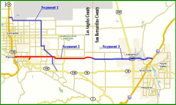
In March 2015, the CTC approved a STIP amendment adjusting the funding for the Route 138 Phase 2 widening. The background on the amendment noted: The Route 138 corridor widening project, located in the cities of Palmdale, Littlerock, Pearblossom and Llana, will widen 18.5 miles, from Avenue T to the Junction with Route 18. The overall project is comprised of thirteen segments that will widen Route 138 from 2 to 4 lanes, including a median turn lane and standard width shoulders.
In March 2015, it was noted that nearly all of the segments have either been completed or are in the construction phase [as of March 2015], with the exception of four segments (Segment 4, 6, 9 and 13).
In May 2015, a CTC agenda item noted that nearly all of the segments have either been completed or are in the construction phase, with the exception of four segments (Segment 4, 6, 9 and 13). Segment 9 will widen approximately 1.8 miles, from just west of 121st Street East to Longview Road and is programmed in the STIP for delivery in Fiscal Year 2015-16. Segment 4 will widen approximately one mile from just west of 72nd Street East to 77th Street East and will be constructed when funding becomes available. The two remaining projects, Segments 6 and 13, are currently programmed in the 2014 STIP for delivery in Fiscal Year 2016-17. Segment 6 is programmed in the STIP for $25,700,000 and will widen approximately one mile from 87th Street East to 96th Street East. The Right of Way (R/W) phase will begin in Fiscal Year 2015-16 and is funded with $12,000,000 from the Regional Improvement Program (RIP) and $1,100,000 from the Local Regional Surface Transportation Program (RSTP). The original R/W estimate was based on a worst case scenario for utility relocations where it would be necessary to relocate all power poles within the project limits. As project development progressed, updated drainage information was obtained which resulted in a significant reduction in the number of needed power pole relocations. Thus, the R/W cost estimate for the project has been reduced by $7,500,000. Segment 13 is programmed in the STIP for $43,900,000 and will widen approximately four miles on Route 138 from just west of 190th Street East to the Route 138/Route 18 Separation and one mile on Route 18 from the Route 138/18 Separation to one mile east of the Route 138/Route 18 Separation. The R/W phase will begin in Fiscal Year 2015-16 and is funded with $6,000,000 from RIP and $1,000,000 from Local RSTP. The R/W estimate for this segment has increased by $3,500,000 due to the need to acquire additional parcels for drainage as well as additional utility relocation costs.
72nd Street East / Segment 4 (~ LA 53.693) to 77th Street East (07-LA-138 53.2/54.2)
 Segment 4 will widen approximately one mile from just
west of 72nd Street East (~ LA 53.693) to 77th Street East (~ LA 54.208)
and will be constructed when funding becomes available.
Segment 4 will widen approximately one mile from just
west of 72nd Street East (~ LA 53.693) to 77th Street East (~ LA 54.208)
and will be constructed when funding becomes available.
The 2018 STIP, approved at the CTC March 2018 meeting, appears to provide a bunch of allocations for the different segments of this project. PPNO 4353 (Widen 4-lanes, Segment 4, 72ndSt E-77th St E) is added, with $39,950K in funding split over FY19-20 and FY21-22.
In March 2020, the CTC approved the 2020 STIP, which
increases programmed funding for PPNO 4353 "Widen 4-lanes, Segment 4, 72nd
St E-77th St E" from $39,950K to $58,350K.
(Source: March 2020 CTC Agenda, Item 4.7, 2020 STIP
Adopted 3/25/2020)
In June 2020, the CTC approved an allocation of
$26,400,000 for the Right of Way capital phase for 07-LA-138 53.2/54.2
PPNO 07-4353 ProjID 0713000500 EA 28600 Widen Conventional Highway
(Segment 4). Route 138 in Littlerock from 0.5 mile west of 72nd
Street East to 77th Street East. Widen conventional highway from 2 lanes
to 4 lanes. The project proposes to widen the conventional highway from
two lanes to four lanes with a median turn lane. The following are
utilities that will need relocation: Charter Communication Company
(cable), Southern California Edison, Southern California Gas (gas line),
Los Angeles County Waterworks District (water line), and American
Telephone and Telegraph. There are 42 parcels that require partial
acquisition and/or temporary construction easements. Thirty-one of the
parcels are residential, while 11 of the parcels are commercial
properties. There is no railroad involvement.
(Source: June 2020 CTC Agenda, Agenda Item
2.5c.(9))
In December 2020, the CTC received notice that
Caltrans will be requesting (at the January meeting) that the California
Transportation Commission (Commission) approve a STIP amendment for the
Widen Conventional Highway (Segment 4) project (PPNO 4353, EA 28600,
07-LA-138 53.2/54.2 53.1/54.3) in Los Angeles
County to delay the construction phase from Fiscal Year 2021-22 to 2022-23
and to change the project limits. The schedule delays are due to obtaining
right of way permits as required for environmental assessment. The
additional time needed to acquire the permits resulted in the project
delivery being delayed from 2021-22 to 2022-23. Once the Environmental
Site Assessment was completed, it was determined that 37 parcels need
Hazardous Waste Site Investigations. This will require 37 right-of-entry
permits that may take approximately 6 to 18 months to obtain and the
timing of this will depend on the cooperation of property owners. A cost
increase is not anticipated due to these schedule delays. The change in
project limits are because, based upon the final design, minor revisions
are being made to the project location description and to the post-miles.
The proposal is to increase the “begin” and “end”
project limits by 0.1 mile at each end of the project. The 0.1 extra
mile is needed in the beginning to ensure a smooth super-elevation
transition which is necessary for a smooth roadway profile for drivers.
The 0.1 extra mile is also needed at the end of project limits to place
detection loops and electrical conduits to connect the loops back to the
controllers. There is no change in total cost of the project due to these
minor changes in project limits. At the January 2021 meeting, this
amendment was approved.
(Source: December 2020 CTC Agenda, Agenda Item
2.1b.(1); January 2021 CTC Agenda, Agenda Item 2.1a.(2))
In March 2023 the CTC was given notice of, and in
May 2023, the CTC approved an amendment to the 2022 SHOPP that revises the
scope and funding plan for two Route 138 Corridor STIP projects, in Los
Angeles County, per STIP Guidelines as follows: (1) The Widen
Conventional Highway (Segment 4) (PPNO 4353) project proposes to (1a)
amend the project scope to provide multimodal transportation access;
(1b) change the project name to “Multimodal Mobility Improvements
(Segment 4)” and (1c) deprogram $13,000,000 of the $20,000,000
programmed of Regional Improvement Program (RIP) funding from the
Construction phase in Fiscal Year 2024-25; (2) the Widen
Conventional Highway (Segment 13) (PPNO 4357) project proposes to (2a)
increase project scope by increasing post mile limits and (2b) program an
additional $13,000,000 of RIP funds which brings the Construction phase
from $40,300,000 to $53,300,000 in Fiscal Year 2023-24. The Multimodal
Mobility Improvements (Segment 4) project (PPNO 4353), previously named
the Widen Conventional Highway, was originally programmed in the 2018 STIP
for the Plans, Specifications and Estimates (PS&E), Right of Way (RW)
and Construction (CON) phases and was carried over into the 2020 and 2022
STIPs. The original scope of work consists of widening the Route 138
conventional highway from two lanes to four lanes between postmile (PM)
53.1 to 54.3. In August 2020, a community outreach meeting was held
that garnered disgruntlement from the Littlerock community because they
liked the rural feel of the town, as with the number of lanes, it
encourages vehicles to drive slower and stop at local businesses.
The community felt with the widened lanes, vehicles may drive through
faster, which raises high speed concerns and potentially economic ones as
its possible customers would not stop at local businesses. In addition, a
number of parcels are needed for the project for right-of-entry permits
for hazardous waste testing that is required. This is proving difficult to
do as some of the property owners are either deceased or live out of
state. With this in mind, Caltrans reevaluated and pivoted to have a
multimodal approach for this project, and updated the scope and presented
it to the Littlerock town council and residents in October 2022, who were
all in support of this alternative. Therefore, the Department and LA Metro
proposed to amending the project to provide multimodal improvements and
enhance safety by eliminating the original scope of widening the highway
to two lanes in each direction. The project name was changed to Multimodal
Mobility Improvements (Segment 4), and the description was updated to
match the revised scope which now includes installation of sidewalks, curb
ramps, traffic calming measures, a traffic signal at 77th Street East,
drainage improvements, and bike lanes. In addition, cost savings of
$13,000,000 for construction, from $20,000,000 to $7,000,000, have been
realized due to the revised scope change. The Route 138 Widening (Segment
6) project (PPNO 4356) is within the same corridor and has been completed
with cost savings of $5,000,000 in Regional Surface Transportation Program
(RSTP) funds. The Widen Conventional Highway (Segment 13) project (PPNO
4357) is programmed in the 2022 STIP for the PS&E, RW and CON phases.
The current scope of work for this consists of widening the Route 138
conventional highway from two lanes to four lanes between PM 66.0 to 70.1,
and on Route 18 between PM 3.4 to 4.5. However, in March 2022, when
the increase to the project limits of the Widen Conventional Highway
(Segment 13) project (PPNO 4357) was approved, the corresponding cost
increase needed for construction was not included, as the project had just
begun the design phase and the revised estimated costs were unknown.
The project has now completed 60 percent review, and a more accurate cost
estimate is available that shows construction cost increased by $18,000,00
to $58,300,000. This additional $18,000,000 being requested for Widen
Conventional Highway (Segment 13) (PPNO 4357) project will come from the
Regional Improvement Program (RIP) and RSTP cost savings from the two
other projects (PPNO 4356 and 4357) within the same corridor. This
amendment proposes to deprogram $13,000,000 of RIP funds for construction
in Fiscal Year 2024-25 from the Multimodal Mobility Improvements (Segment
4) project (PPNO 4353) and reprogram these funds for construction in
2023-24 for the Widen Conventional Highway (Segment 13) project (PPNO
4357), in Los Angeles County.
(Source: March 2023 CTC Agenda, Agenda Item 2.1b.(3); May 2023 CTC
Agenda, Agenda Item 2.1a.(4))
87th Street East (~LA 55.216) to 96th Street East (~ LA 56.187)
 (March 2015) Segment 6 is programmed in the STIP for
$25,700,000 and will widen approximately one mile from 87th Street East
(~LA 55.216) to 96th Street East (~ LA 56.187). The Right of Way (R/W)
phase will begin in Fiscal Year 2015-16 and is funded with $12,000,000
from the Regional Improvement Program (RIP) and $1,100,000 from the Local
Regional Surface Transportation Program (RSTP). The original R/W estimate
was based on a worst case scenario for utility relocations where it would
be necessary to relocate all power poles within the project limits. As
project development progressed, updated drainage information was obtained
which resulted in a significant reduction in the number of needed power
pole relocations. Thus, the R/W cost estimate for the project has been
reduced by $7,500,000. The Department proposes to reduce the RIP
programming for R/W from $12,000,000 to $4,500,000 and re-program the
$7,500,000 in savings to Segment 13 to address cost increases. Segments 6
and 13, are currently programmed in the 2014 STIP for delivery in Fiscal
Year 2016-17. In March 2015, a STIP amendment adjusted the funding for
Segments 6 and 13
(March 2015) Segment 6 is programmed in the STIP for
$25,700,000 and will widen approximately one mile from 87th Street East
(~LA 55.216) to 96th Street East (~ LA 56.187). The Right of Way (R/W)
phase will begin in Fiscal Year 2015-16 and is funded with $12,000,000
from the Regional Improvement Program (RIP) and $1,100,000 from the Local
Regional Surface Transportation Program (RSTP). The original R/W estimate
was based on a worst case scenario for utility relocations where it would
be necessary to relocate all power poles within the project limits. As
project development progressed, updated drainage information was obtained
which resulted in a significant reduction in the number of needed power
pole relocations. Thus, the R/W cost estimate for the project has been
reduced by $7,500,000. The Department proposes to reduce the RIP
programming for R/W from $12,000,000 to $4,500,000 and re-program the
$7,500,000 in savings to Segment 13 to address cost increases. Segments 6
and 13, are currently programmed in the 2014 STIP for delivery in Fiscal
Year 2016-17. In March 2015, a STIP amendment adjusted the funding for
Segments 6 and 13
The 2018 STIP, approved at the CTC March 2018 meeting, appears to provide a bunch of allocations for the different segments of this project. PPNO 4356, Widening Segment 6, 87th St E-96th St E, has $19,750K in construction and construction support funding restored for FY19-20.
In June 2018, the CTC approved amending the STIP in
response to a request from LA Metro. The Los Angeles County Metropolitan
Transportation Authority (Metro) proposes to amend the STIP to program an
AB 3090 Replacement project (PPNO 4356A) in Fiscal Year (FY) 2020-21 in
place of the Route 138 Widening, Segment 6 project (PPNO 4356) in Los
Angeles County, currently programmed for $19,750,000 in FY 2019-20. The
Department is ready to deliver the Route 138 Widening project with local
funds in FY 2018-19. The State Route 138 Widening, Segment 6 project will
widen the conventional highway from 2 lanes to 4 lanes, from 87th Street
East to 96th Street East in Los Angeles County. The project was originally
programmed for delivery in FY 2016-17. However, due to reduced STIP
capacity, the construction programming was deleted as part of the 2016
STIP adoption. The funding has now been restored in the adopted 2018 STIP
with construction and construction support programmed for $19,750,000 in
FY 2019-20. This project is the highest priority project for the region
and is currently ready to be advertised. Metro proposes to fund the
construction and construction support components with locally-controlled
federal funds in order for the Department to accelerate delivery in FY
2018-19.
(Source: CTC Agenda, June 2018 Agenda Item 2.1a(3))
In March 2020, the CTC approved the 2020 STIP, which
continues the programmed funding of $4,500K for PPNO 4356 "Widen 4-lanes,
Segment 6, 87th St E-96th St E (18S-01)".
(Source: March 2020 CTC Agenda, Item 4.7, 2020 STIP
Adopted 3/25/2020)
96th Street East (~ LA 56.178) to 106th Street East (~LA 57.178)
In late 2007, Caltrans advertised bids to widen Route 138 to four lanes near Littlerock from 96th Street East (~ LA 56.178) to 106th Street East (~LA 57.178).
Big Rock Wash (~ LA 061.70)
In July 2005, the CTC considered funding to widen from 2 to 4 lanes with median turn lane the segment near Pearblossom at the Twin Bridges over Big Rock Wash (~ LA 061.70).
The SAFETEA-LU act, enacted in August 2005 as the reauthorization of TEA-21, provided $400,000 in funding for High Priority Project #2542, which would replace twin two-lane bridges with single four-lane bridge on Route 138 over Big Rock Wash (~ LA 061.70).
121st Street East (~ LA 59.172) to Longview Road (~ LA 60.172)
Segment 9 will widen approximately 1.8 miles, from just west of 121st Street East (~ LA 59.172) to Longview Road (~ LA 60.172) and is programmed in the STIP for delivery in Fiscal Year 2015-16.
In June 2016, the CTC adjusted funding for the Route 138 Widening, Segment 9. Near Pearblossom, from 0.7 mile west of 121st Street East to Longview Road. Widen from 2 to 4 lanes with a median turn lane. CON ENG increase of $285,000 and CONST increase of $1,218,000 to come from Los Angeles County regional shares.
175th St (~ LA 64.687) and Largo Vista Road (~ LA 67.876)
2007 CMIA. The following project on Route 138 in Los Angeles County was submitted to the Corridor Mobility Improvement Account for funding: widening the route to 4 lanes between 175th St (~ LA 64.687) and Largo Vista Road (~ LA 67.876) ($15.8 million). Not recommended for funding.
In August 2011, the CTC approved $17,632,000 in State Administered STIP Project funding for a project near Llano, from 175th Street East to Largo Vista Road, that will widen the segment from two to four lanes with a median turn lane and standard shoulder.
190th Street East (~ LA 66.377) to the Route 138/Route 18 Separation (~LA 69.33)
(March 2015) Segment 13 is programmed in the STIP for $43,900,000 and will widen approximately four miles on Route 138 from just west of 190th Street East (~ LA 66.377) to the Route 138/Route 18 Separation (~LA 69.33) and one mile on Route 18 from the Route 138/Route 18 Separation (~ 018 LA 4.396) to one mile east of the Route 138/Route 18 Separation (~ LA 3.396). The R/W phase will begin in Fiscal Year 2015-16 and is funded with $6,000,000 from RIP and $1,000,000 from Local RSTP. The R/W estimate for this segment has increased by $3,500,000 due to the need to acquire additional parcels for drainage as well as additional utility relocation costs. The Department proposes to increase the RIP programming for R/W from $6,000,000 to $9,500,000. The construction phase is funded with $31,400,000 from RIP and $4,600,000 from Local RSTP. During the design phase, the Department identified the need to add an additional passing lane at the connector of eastbound Route 138 to eastbound Route 18 to improve safety and operations. This revision to the design increased the construction estimate by $4,000,000. The Department proposes to increase the RIP programming for construction capital from $31,400,000 to $35,400,000. Segments 6 and 13, are currently programmed in the 2014 STIP for delivery in Fiscal Year 2016-17. In March 2015, a STIP amendment adjusted the funding for Segments 6 and 13
The 2018 STIP, approved at the CTC March 2018 meeting, appears to provide a bunch of allocations for the different segments of this project. PPNO 4357, Widening Segment 13, 190th St E - Rt 18, has its funding restored and brought up to $80,500K, with construction in FY22-23.
In March 2020, the CTC approved the 2020 STIP, which
changed the name of PPNO 4357 "Widen 4-lanes, Segment 13, 190th St E-Rt
18" to "Widen 4-lanes, Segment 13, 190th St E-213 St E", and adjusted the
programmed funding from $80,500K to $62,100K.
(Source: March 2020 CTC Agenda, Item 4.7, 2020 STIP
Adopted 3/25/2020)
In March 2023, the CTC was given notice of, and in
May 2023, the CTC approved, an amendment to the 2022 SHOPP that revises
the scope and funding plan for two Route 138 Corridor STIP projects, in
Los Angeles County, per STIP Guidelines as follows: (1) The Widen
Conventional Highway (Segment 4) (PPNO 4353) project proposes to (1a)
amend the project scope to provide multimodal transportation access; (1b)
change the project name to “Multimodal Mobility Improvements
(Segment 4)” and (1c) deprogram $13,000,000 of the $20,000,000
programmed of Regional Improvement Program (RIP) funding from the
Construction phase in Fiscal Year 2024-25; (2) the Widen
Conventional Highway (Segment 13) (PPNO 4357) project proposes to (2a)
increase project scope by increasing post mile limits and (2b) program
an additional $13,000,000 of RIP funds which brings the Construction
phase from $40,300,000 to $53,300,000 in Fiscal Year 2023-24.
The Multimodal Mobility Improvements (Segment 4) project (PPNO 4353),
previously named the Widen Conventional Highway, was originally programmed
in the 2018 STIP for the Plans, Specifications and Estimates (PS&E),
Right of Way (RW) and Construction (CON) phases and was carried over into
the 2020 and 2022 STIPs. The original scope of work consists of
widening the Route 138 conventional highway from two lanes to four lanes
between postmile (PM) 53.1 to 54.3. In August 2020, a community
outreach meeting was held that garnered disgruntlement from the Littlerock
community because they liked the rural feel of the town, as with the
number of lanes, it encourages vehicles to drive slower and stop at local
businesses. The community felt with the widened lanes, vehicles may
drive through faster, which raises high speed concerns and potentially
economic ones as its possible customers would not stop at local
businesses. In addition, a number of parcels are needed for the project
for right-of-entry permits for hazardous waste testing that is required.
This is proving difficult to do as some of the property owners are either
deceased or live out of state. With this in mind, Caltrans reevaluated and
pivoted to have a multimodal approach for this project, and updated the
scope and presented it to the Littlerock town council and residents in
October 2022, who were all in support of this alternative. Therefore, the
Department and LA Metro proposed to amending the project to provide
multimodal improvements and enhance safety by eliminating the original
scope of widening the highway to two lanes in each direction. The project
name was changed to Multimodal Mobility Improvements (Segment 4), and the
description was updated to match the revised scope which now includes
installation of sidewalks, curb ramps, traffic calming measures, a traffic
signal at 77th Street East, drainage improvements, and bike lanes.
In addition, cost savings of $13,000,000 for construction, from
$20,000,000 to $7,000,000, have been realized due to the revised scope
change. The Route 138 Widening (Segment 6) project (PPNO 4356) is within
the same corridor and has been completed with cost savings of $5,000,000
in Regional Surface Transportation Program (RSTP) funds. The Widen
Conventional Highway (Segment 13) project (PPNO 4357) is programmed in the
2022 STIP for the PS&E, RW and CON phases. The current scope of work
for this consists of widening the Route 138 conventional highway from two
lanes to four lanes between PM 66.0 to 70.1, and on Route 18 between PM
3.4 to 4.5. However, in March 2022, when the increase to the project
limits of the Widen Conventional Highway (Segment 13) project (PPNO 4357)
was approved, the corresponding cost increase needed for construction was
not included, as the project had just begun the design phase and the
revised estimated costs were unknown. The project has now completed
60 percent review, and a more accurate cost estimate is available that
shows construction cost increased by $18,000,00 to $58,300,000. This
additional $18,000,000 being requested for Widen Conventional Highway
(Segment 13) (PPNO 4357) project will come from the Regional Improvement
Program (RIP) and RSTP cost savings from the two other projects (PPNO 4356
and 4357) within the same corridor. This amendment proposes to deprogram
$13,000,000 of RIP funds for construction in Fiscal Year 2024-25 from the
Multimodal Mobility Improvements (Segment 4) project (PPNO 4353) and
reprogram these funds for construction in 2023-24 for the Widen
Conventional Highway (Segment 13) project (PPNO 4357), in Los Angeles
County.
(Source: March 2023 CTC Agenda, Agenda Item 2.1b.(3); May 2023 CTC
Agenda, Agenda Item 2.1a.(4))
Route 138 Widening / Safety Improvements — Route 18 to SBd County/Phelan Road
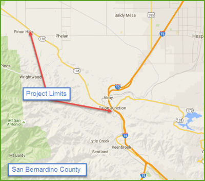
Widening - LA County Line to near Phelan Road (08-SBd-138, PM 0.0/2.3 07-LA-138, PM 74.9)
 The 2020 SHOPP, approved in May 2020, included the
following Collision Reduction item of interest (carried over from the 2018
SHOPP): 08-San Bernardino-138 PM 0.0/2.3 PPNO 3010F Proj ID 0817000139 EA
1H830. Route 138 near Pinon Hills, from Los Angeles County line to 0.6
mile west of Phelan Road; also in Los Angeles County, from 0.1 mile west
of the San Bernardino County line to the San Bernardino County line (PM
74.90/74.973). Widen roadway to provide up to 4 foot median, widen
shoulders, and construct rumble strips. Programmed in FY21-22, with
construction scheduled to start in February 2022. Total project cost is
$10,361K, with $6,607K being capital (const and right of way) and $3,754K
being support (engineering, environmental, etc.).
The 2020 SHOPP, approved in May 2020, included the
following Collision Reduction item of interest (carried over from the 2018
SHOPP): 08-San Bernardino-138 PM 0.0/2.3 PPNO 3010F Proj ID 0817000139 EA
1H830. Route 138 near Pinon Hills, from Los Angeles County line to 0.6
mile west of Phelan Road; also in Los Angeles County, from 0.1 mile west
of the San Bernardino County line to the San Bernardino County line (PM
74.90/74.973). Widen roadway to provide up to 4 foot median, widen
shoulders, and construct rumble strips. Programmed in FY21-22, with
construction scheduled to start in February 2022. Total project cost is
$10,361K, with $6,607K being capital (const and right of way) and $3,754K
being support (engineering, environmental, etc.).
(Source: 2020 Approved SHOPP a/o May 2020)
In October 2020, the CTC approved for future
consideration of funding the following project for which a Mitigated
Negative Declaration (MND) has been completed: Route 138 in San Bernardino
and Los Angeles counties. Install median, shoulder rumble strips,
and make other improvements on Route 138 in San Bernardino and Los Angeles
Counties. (PPNO 3010F) This project is located on Route 138 in San
Bernardino and Los Angeles Counties. The Department proposes to add a
4-foot buffer in the median and install median and shoulder rumble strips
near Pinon Hills and Phelan to improve highway safety. This project is
currently programmed in the 2020 SHOPP for a total of $10,361,000 which
includes Construction (capital and support) and Right of Way (capital and
support). Construction is estimated to begin 2021-2022. The scope, as
described for the preferred alternative, is consistent with the project
scope programmed by the Commission in the 2020 SHOPP.
(Source: October 2020 CTC Agenda, Agenda Item
2.2c.(1))
In October 2020, the CTC approved the following
SHOPP Support Phase allocation: $1,200,000 for PS&E and $75,000 for
R/W Sup for 07-LA-138 PM 74.90/74.973 / 08-SBd-138 0.0/2.3. PPNO 3010F
ProjID 0817000139 EA 1H830. Route 138 Near Pinon Hills, from Los Angeles
County line to 0.6 mile west of Phelan Road; also in Los Angeles County,
from 0.1 mile west of the San Bernardino County line to the San Bernardino
County line (PM 74.90/74.973). Widen roadway to provide up to 4 foot
median, widen shoulders, and construct rumble strips. (Concurrent
consideration of funding under Resolution E-20-93; October 2020.)
(Source: October 2020 CTC Agenda, Agenda Item
2.5b.(2a) #31)
In August 2021, the CTC was informed of the
following SHOPP Safety Resolution G-03-10 Delegated Allocation:
$8,146,000. 08-SBd-138 0.0/2.3. PPNO 08-3010F; ProjID 0817000139; EA
1H830. Route 138 Near Pinon Hills, from Los Angeles County line to 0.6
mile west of Phelan Road; also in Los Angeles County, from 0.1 mile west
of the San Bernardino County line to the San Bernardino County line (PM
74.90/74.973). Outcome/Output: Inprove safety by widening roadway to
provide up to a 14 foot median, widening shoulders, and constructing
rumble strips. This project will reduce the number and severity of
collisions. (Future consideration of funding approved under Resolution
E-20-93; October 2020.) Allocation Date: 07/15/2021. Allocation division:
CON ENG $1,629,000; CONST $6,387,000.
(Source: August 2021 CTC Agenda, Agenda Item
2.5f.(3) #8)
In February 2022, it was reported that Caltrans has
announced a roadway widening project was starting on Route 138 in Phelan
from the Los Angeles County line to west of Phelan Road. The $4.3 million
contract was awarded to Granite Construction Company for crews to widen
the roadway and provide a 14-foot median, wider shoulders and install
center rumble strips. Construction will begin with surveying and pavement
testing. This project is anticipated to end fall of 2023 but is subject to
change, due to weather or other construction issues.
(Source: Victorville Daily Press, 2/2/2022)
Route 138 Widening / Safety Improvements — SBd County/Phelan Road to I-15 (~ SBD 3.093 to SBD R14.945)
In December 2013, the CTC approved for future consideration of funding a project to widen a portion of Route 138 from two lanes to four lanes, construct a median, and realign portions of the highway. The project will be constructed in two phases, and is fully funded for Phase 1 only. Phase 1 is in San Bernardino County from Phelan Road to I-15. This phase is programmed in the 2012 State Transportation Improvement Program. The total estimated cost is $88,420,000 for capital and support. Construction for Phase 1 is estimated to begin in Fiscal Year 2013-14. Phase 2 begins in Los Angeles County at State Route 18 and extends into San Bernardino County, ending at Phelan Road. This phase is not yet funded, but is anticipated to be programmed in the 2014 State Transportation Improvement Program. The total estimated cost is $72,500,000 for capital and support. Depending on the availability of funding, construction for Phase 2 is estimated to begin in Fiscal Year 2016-17. Environmental mitigation measures include, but are not limited to, a vista point being developed in the vicinity of Route 138 and Lone Pine Canyon Road, rock faces shall be provided with a similar surface as the nearby Mormon Rocks formation, and Joshua trees removed during construction will be replanted away from proposed pavement areas.
In March 2014, the CTC allocated addition funding for the Route 138 Widening (Segment 1). In Wrightwood, from Phelan Road to Junction Route 15. Widen from 2 to 4 lanes and construct 4 foot median buffer.
 In August 2016, the CTC authorized that $3,646,000 be allocated from Budget Act Item
2660-001-0890, to provide construction support funds to complete
construction. This project is located in San Bernardino County on Route 138, in the city of Wrightwood from Phelan Road to Junction Route 15. The
project will widen Route 138 from two to four lanes and construct a
four-foot median buffer. This project was programmed in the 2014 STIP for
construction support and was allocated in March 2014 for $7,054,000. The
construction capital portion of this project was allocated for
$52,097,000. An additional $3,646,000 in construction support is needed to
complete the construction of this project. The construction support cost
increase is due to major delays during construction of this project. This
is a large and complex project with many resource agencies involved. The
project experienced delays due to permit restriction to one bridge,
railroad impacts, and utility relocation, and caused a delay of more than
one year. The original schedule was to complete the construction in two
years. However, due to these delays, the construction duration was
extended by one year, resulting in the need for additional funds for
construction support.
In August 2016, the CTC authorized that $3,646,000 be allocated from Budget Act Item
2660-001-0890, to provide construction support funds to complete
construction. This project is located in San Bernardino County on Route 138, in the city of Wrightwood from Phelan Road to Junction Route 15. The
project will widen Route 138 from two to four lanes and construct a
four-foot median buffer. This project was programmed in the 2014 STIP for
construction support and was allocated in March 2014 for $7,054,000. The
construction capital portion of this project was allocated for
$52,097,000. An additional $3,646,000 in construction support is needed to
complete the construction of this project. The construction support cost
increase is due to major delays during construction of this project. This
is a large and complex project with many resource agencies involved. The
project experienced delays due to permit restriction to one bridge,
railroad impacts, and utility relocation, and caused a delay of more than
one year. The original schedule was to complete the construction in two
years. However, due to these delays, the construction duration was
extended by one year, resulting in the need for additional funds for
construction support.
The 2020 STIP, approved at the March 2020 CTC meeting,
included PPNO 0239D, Widening, LA Co-Rt 15, Segment 1 (IIP) (CCA 6-19), in
the Interregional portion of the STIP with no change in programming:
$4,833K in prior year closeout funding.
(Source: March 2020 CTC Agenda, Item 4.7, 2020 STIP
Adopted 3/25/2020)
There are plans to add truck lanes and shoulders near Wrightwood. April 2005 CTC Agenda (~ SBD 6.451).
Route 15 near Hesperia to Route 18
Hesparia Safety Improvements - SBD R14.8/R15.1
In December 2018, the CTC approved an allocation of
$1,160,000 for Project Support and Engineering for 08-SBd-138 R15.0/R15.1.
PPNO 3010W. Project No. 0817000138. Route 138 Near Hesperia, from Cajon
Boulevard to the Route 15 southbound offramp. Install traffic signals,
realign Cajon Boulevard, widen southbound offramp, add left turn lane and
construct curb ramps.
(Source: December 2018 CTC Minutes, Agenda Item
2.5b(2a), Item 27)
In August 2019, the CTC approved the following
allocation: 08-SBd-138 R15.0/R15.1. PPNO 3010W. Proj ID 0817000138 EA
1H820 Route 138 Near Hesperia, from Cajon Boulevard to the Route 15
southbound offramp. Install traffic signals, realign Cajon Boulevard,
widen southbound offramp, add left turn lane, and construct curb ramps.
R/W Sup $255,000
(Source: August 2019 CTC Agenda, Agenda Item
2.5b.(2a) #35)
In October 2019, the CTC amended this item: 08-SBd-138
R15.0/R15.1 R14.8/R15.1 PPNO 3010W Proj ID
0817000138. EA 1H820. Near Hesperia, from Cajon Boulevard to the
Route 15 southbound offramp 0.1 mile west to 0.2 mile east
of Cajon Creek Bridge; also on Route 15, at 0.2 mile north of Route 138
(PM R21.6). Install traffic signals, realign Cajon Boulevard,
widen southbound offramp, add left turn lane, and construct curb ramps.
(Source: October 2019 CTC Agenda, Agenda Item
2.1a.(1) Amendment Item 31)
The 2020 SHOPP, approved in May 2020, included the
following Collision Reduction item of interest (carried over from the 2018
SHOPP): 08-San Bernardino-138 PM R14.8/R15.1 PPNO 3010W Proj ID 0817000138
EA 1H820. Route 138 near Hesperia, from 0.1 mile west to 0.2 mile east of
Cajon Creek Bridge; also on Route 15, at 0.2 mile north of Route 138 (PM
R21.6). Install traffic signals, realign Cajon Boulevard, widen
southbound offramp, add left turn lane, and construct curb ramps.
Programmed in FY21-22, with construction scheduled to start in January
2022. Total project cost is $6,208K, with $3,173K being capital (const and
right of way) and $3,035K being support (engineering, environmental,
etc.).
(Source: 2020 Approved SHOPP a/o May 2020)
In January 2022, the CTC approved the following
allocation: $3,848,000. 08-SBd-138 R14.8/R15.1. PPNO 08-3010W; ProjID
0817000138; EA 1H820. Route 138 Near Hesperia, from 0.2 mile west to 0.1
mile east of Cajon Boulevard; also on Route 15, at 0.2 mile north of Route 138 (PM R21.6). Outcome/Output: Install traffic signals, realign
Cajon Boulevard, widen southbound offramp, add left-turn lane, and
construct curb ramps to improve safety. This project will reduce the
number and severity of collisions. Allocation: CON ENG $1,050,000; CONST
$2,488,000.
(Source: January 2022 CTC Agenda, Agenda Item
2.5f.(3) #1)
In August 2022, the CTC approved a request for an
additional $669,000 in CONST funds for the SHOPP Safety Improvements
project on Route 138, in San Bernardino County, to award the construction
contract. The project (08-SBd-138 R14.8/R15.1, PPNO 08-3010W; ProjID
0817000138; EA 1H820) is located on Route 138 near the City of Hesperia,
at the I-15 Interchange, in San Bernardino County. The project will
install traffic signals, realign Cajon Boulevard, widen the southbound
off-ramp and add a left turn lane, and construct curb ramps. In August
2018, the project was programmed for $2,488,000 in Construction Capital in
the SHOPP for allocation in Fiscal Year 2021-22. In December 2021, the
project was allocated for $2,608,000 in Construction Capital and received
an 8-month expenditure time extension to complete the Plans,
Specifications, and Estimate phase. In June 2022, the project
received a 6-month award time extension. Bids were opened in April
2022, and the amount required to award to the lowest bidder exceeded the
amount available from project allocated and G-12 funds. However, in March
2022, the Department advertised the contract and held bid opening in April
2022. The contract received seven bids, of which, the lowest bid is 27.8
percent above the Engineer’s Estimate (EE). The six remaining bids
ranged in costs from 33.7 to 57.8 percent over the EE.The cost increases
on this project are largely attributed to the current state of the economy
with supply shortages, inflation, and high fuel prices. The
Department interviewed all bidders to discuss the discrepancy in item unit
costs. The contractors cited uncertainty of material prices as a
major factor impacting the bids for steel, electrical components, hot
asphalt mix, and labor supply. Electrical components have become difficult
to acquire and have experienced significant cost increases. As a
result of high fuel and trucking costs, the cost of supplying and placing
roadway material has been significantly impacted. Other major unit
price differences include Signal and Lighting System - 105 percent higher
(increased by $375,000); Mobilization - 40 percent higher (increased by
$78,000); and Hot Mix Asphalt (Type A) - 40 percent higher (increased by
$72,000). In aggregate, these items amount to an increase of $525,000 over
the EE. The remaining increase is due to minor unit price cost
increases of other bid items.
(Source: August 2022 CTC Agenda, Agenda Item
2.5e.(9))
Highway 138 East Alignment Project.
In December 2004, the CTC considered funding a project on Route 138 that received a negative EIR; specifically, a realignment of the highway in the Cajon Pass (~ SBD R15.272).
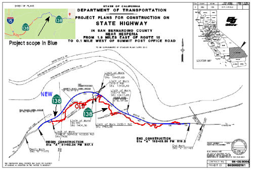
In January 2015, it was reported that Caltrans is
planning improvements for Route 138 E of I-15. Specifically, in Summer
2015, Caltrans will be seeking bids on a $31 million project to widen and
realign the two-lane highway. The project will begin 1.9 miles east of
I-15 (~ SBD R17.1) and continue to one-tenth of a mile west of Summit Post
Office Road (~ SBD 19.369). The realignment will reduce the number of
curves on that extremely curvy stretch of Route 138, which should improve
safety. The majority of the realignment will be done to the north of the
existing road. While the widening of Route 138 won’t add new lanes,
it will increase lanes to 12 feet and add eight-foot paved shoulders. The
project also calls for three bridges to be added for wildlife crossing at
Hog Ranch Creek, Miner’s Shack Creek and Double Drain Creek. An
off-highway vehicle crossing also will be added. Construction is expected
to start in late 2015 or in early 2016.
(Source: Victor Valley Daily Press, 12/26/2014)
 In September 2016, it was reported that the Route 138
East Alignment Project, which will eliminate switchbacks and steep grades,
was starting. The $23 million project will straighten the roadway that
leads into south Hesperia and toward Silverwood Lake from I-15. The
project has an expected summer 2018 completion date. The project will
create a new road between the current highway and the railroad tracks. No
additional lanes are included in the project, which will realign the
roadway and construct outside shoulders and three wildlife crossings on
Route 138 near Hesperia from 1.9 miles east of I-15 to 0.1 miles west of
Summit Post Office Road, officials said. The improved two-lane road, with
one lane in each direction, will be a mile shorter than the existing
route. The realignment project will improve operational efficiency and
upgrade and widen existing lanes and shoulders to current standards,
according to officials. The existing highway's configuration has many
nonstandard horizontal and vertical curves, and grades as steep as 15
percent. The existing pavement is from 21 feet to 28 feet wide, with no
paved shoulders and narrow or nonexistent earth shoulders. The new highway
will have full 12-foot lanes in each direction, plus full shoulders of 8
to 10 feet each. Once completed, the 22-foot-wide paved roadway will
increase to 40 feet. Once completed, the speed limit will be 55 mph,
compared to the current 15-20 mph on some of the switchbacks and hairpin
turns.
In September 2016, it was reported that the Route 138
East Alignment Project, which will eliminate switchbacks and steep grades,
was starting. The $23 million project will straighten the roadway that
leads into south Hesperia and toward Silverwood Lake from I-15. The
project has an expected summer 2018 completion date. The project will
create a new road between the current highway and the railroad tracks. No
additional lanes are included in the project, which will realign the
roadway and construct outside shoulders and three wildlife crossings on
Route 138 near Hesperia from 1.9 miles east of I-15 to 0.1 miles west of
Summit Post Office Road, officials said. The improved two-lane road, with
one lane in each direction, will be a mile shorter than the existing
route. The realignment project will improve operational efficiency and
upgrade and widen existing lanes and shoulders to current standards,
according to officials. The existing highway's configuration has many
nonstandard horizontal and vertical curves, and grades as steep as 15
percent. The existing pavement is from 21 feet to 28 feet wide, with no
paved shoulders and narrow or nonexistent earth shoulders. The new highway
will have full 12-foot lanes in each direction, plus full shoulders of 8
to 10 feet each. Once completed, the 22-foot-wide paved roadway will
increase to 40 feet. Once completed, the speed limit will be 55 mph,
compared to the current 15-20 mph on some of the switchbacks and hairpin
turns.
(Source: Victor Valley Daily Press, 9/5/2016)
In February 2018, it was reported that Caltrans
continues work on the $23 million Route 138 East Realignment Project. The
project is located on Route 138 just east of I-15 to Summit Post Office
Road. The realignment will remove several curves and steep grades reducing
the three-mile stretch by one mile. The project also includes constructing
outside shoulders, three bridges, and three wildlife crossings. Route 138
will remain a two-lane road with one lane in each direction. As of
February 2018, construction crews were working on bridge structures and
drainage. On February 21st, crews geared up for additional pavement work
that will require a ten-day traffic detour. During early March, motorists
drove on portions of the realigned roadway while crews focus on building
the last 2,500 feet of new roadway, abandoning the current Route 138
roadway, and drainage. To date construction work is 80% complete. The
project is on schedule and within budget.
(Source: Caltrans District 8 Commuter Alert, 2/8/2018)
Cajon Junction Curve Realignment (08-SBd-138 T16.3/R17.3)
In August 2022, the CTC amended the following project
into the SHOPP: 08-SBd-138 T16.3/R17.3. PPNO 08-3019X; ProjID 0821000070;
EA 1M080. Route 138 Near Cajon Junction, from 1.0 mile east of Wagon Train
Road to Hog Ranch Creek Bridge. Realign horizontal and
vertical curves, construct 8-foot shoulders, and install rumble strips and
guardrail. Allocation ($ × 1,000): PA&ED $1,580; PS&E $1,852;
R/W Sup $177; Con Sup $1,933; R/W Cap $216; Const Cap: $8,421; Total
$14,179. Begin Const: 11/17/2026. Concurrent COS allocation under
Resolution FP-22-11; August 2022.
(Source: August 2022 CTC Agenda, Agenda Item
2.1a.(1a) #21)
In August 2022, the CTC approved the following
pre-construction phase allocation: $1,580,000. 08-SBd-138
T16.3/R17.3. PPNO 08-3019X; ProjID 0821000070; EA 1M080. Route 138 Near
Cajon Junction, from 1.0 mile east of Wagon Train Road to Hog Ranch Creek
Bridge. Realign horizontal and vertical curves, construct 8-foot
shoulders, and install rumble strips and guardrail. Allocation: FY25-26
PA&ED $1,580,000. Concurrent Amendment under SHOPP Amendment 22H-003;
August 2022.
(Source: August 2022 CTC Agenda, Agenda Item 2.5b.(2a) #19)
In June 2023, the CTC amended the following project in
the 2022 SHOPP: 08-SBd-138 T16.3/R17.3. PPNO 08-3019X; ProjID 0821000070;
EA 1M080. Route 138 Near Cajon Junction, from 1.0 mile east of Wagon Train
Road to Hog Ranch Creek Bridge. Realign horizontal and vertical
curves, construct 8-foot shoulders, and install rumble strips and
guardrail. Note: An additional culvert and Rock Slope Protection (RSP)
will be added to this project to increase climate resiliency. Increase
construction capital to add these items to the project. This additional
need will be funded through Infrastructure Investment and Jobs Act (IIJA)
funds. Allocation Changes ($ × 1,000): PS&E $1,852 $1,922;
Con Sup $1,933 $2,003; Const Cap $8,421
$10,281; Total $14,179 $16,179.
(Source: June 2023 CTC Agenda, Agenda Item 2.1a.(1d) #69)
Metropolitan Bypass Freeway/High Desert Corridor
Route 138 was to have been the "Metropolitan Bypass" freeway; only the Route 5/Route 138 interchange was constructed to freeway standards. If built, it would have continued past Route 18 to Route 15. It is unconstructed between Routes 14 and Route 48. However, the Metropolitan Bypass isn't dead. The Southern California Association of Governments (SCAG) and the Metropolitan Transportation Agency (MTA) are exploring a plan to construct a new east-west highway that roughly follows the current path of Route 138. This would not only serve north county communities but also divert truck traffic now pouring into the Los Angeles Basin via I-5. In August 2001, the MTA launched a study of north county highway corridors. The first phase focused on the Golden State and Antelope Valley freeways and such proposed improvements as widening and adding lanes. The study's second part, which began in May 2002, examined Route 138, also known as Lancaster Road and Avenue D in the western portion, and Pearblossom Highway in the east. The MTA's proposal for the roadway includes widening the western portion, which connects the Golden State and Antelope Valley freeways, into a divided highway with three lanes in each direction. In the eastern portion, the MTA proposes constructing a freeway with as many as four lanes in each direction along Avenue P-8, between the Antelope Valley and Mojave freeways, a few blocks north of the Pearblossom Highway. A Pearblossom Highway routing was rejected because of community opposition and anticipated construction difficulties.
![[High Desert Corridor Map]](maps/hdcorridor.jpg) There
may still be plans to build the Metropolitan Bypass Freeway, now called
the High Desert Corridor. Some of the funding for this may be provided by
the state of Nevada, according to an LVRJ article. According to the
article, the California Department of Transportation recently completed
its study of a proposed six-lane highway, dubbed the High Desert Corridor,
to link Palmdale and Victorville. By facilitating travel between I-15 and
I-5, the $1.5 billion project would help alleviate congestion on I-15,
which is a major concern to area tourism officials. The State Senate has
approved legislation (which still requires assembly concurrance and the
Governor's signature) authorizing Caltrans to look for a private company
to build a new east-west highway across the eastern Antelope Valley as a
toll road. This toll road would be located a few miles north but parallel
to Route 138. The route number is uncertain: it could end up being a
rerouting of Route 138; it could end up as Route 48; or it could get a new
number. Caltrans materials refers to it as a Route 138 project.
There
may still be plans to build the Metropolitan Bypass Freeway, now called
the High Desert Corridor. Some of the funding for this may be provided by
the state of Nevada, according to an LVRJ article. According to the
article, the California Department of Transportation recently completed
its study of a proposed six-lane highway, dubbed the High Desert Corridor,
to link Palmdale and Victorville. By facilitating travel between I-15 and
I-5, the $1.5 billion project would help alleviate congestion on I-15,
which is a major concern to area tourism officials. The State Senate has
approved legislation (which still requires assembly concurrance and the
Governor's signature) authorizing Caltrans to look for a private company
to build a new east-west highway across the eastern Antelope Valley as a
toll road. This toll road would be located a few miles north but parallel
to Route 138. The route number is uncertain: it could end up being a
rerouting of Route 138; it could end up as Route 48; or it could get a new
number. Caltrans materials refers to it as a Route 138 project.
The SAFETEA-LU act, enacted in August 2005 as the reauthorization of TEA-21, provided the following expenditures on or near this route:
According to Chris Sampang, the Palmdale bypass for Route 138 is apparantly planned to begin at where Route 14/138 crosses over Avenue P8 southeast of the Antelope Valley Mall; the new route would then follow Avenue P8's corridor east (passing south of the Desert Aire Golf Course) staying north of Palmdale Boulevard (and bypassing Antelope Center as well in the process). At the Rock Creek, the Route 138 bypass would curve to the south and then cross Avenue T and the railroad tracks southbound, before curving southeast to meet up with existing Route 138 halfway between Pearblossom and Llano.
According to Jonathan Goff, the HDC will be routed along Ave P-8 (Technology Drive) from Route 14 to I-15 in Adelanto. It will be full freeway from the Route 14 till 50th East. There will be offramps serving the airport and Plant 42. There will a 6 lane freeway/expressway spur running N/S along 50th East to Palmdale Blvd that will meet with the HDC. The portion from 50th East to the 240th East will be mix of 6 lane freeway/express way. The HDC will be 6 lane expressway from 240th East till US 395. Past US 395 it will be 4 lane expressway and it will cross the I-15 and run into Apple Valley for another 8-10 miles. The MTA is planning on purchasing sufficient ROW to allow for future expansion. They are allowing for future conversion to full freeway on many of the AV's highways beyond what is currently proposed. However, there are no plans on making a northern extension route of Route 138 to US 395 or to I-15; however, Route 58 could have some additional work on it allowing for more traffic.
The AV Daily Press had an article on the HDC where they discussed the routing in the Victorville area, and provided a small map. The article notes that the corridor is a freeway that would connect US 395 to a new interchange on I-15 north of Stoddard Wells Road, along a route closely paralleling Air Expressway. East of I-15, the route would travel through Apple Valley north of Route 18, curving south to join Route 18 near Joshua Road. Note that this is significantly N of Route 138. The article goes on to note that, according to SANBAG, the corridor's first section, connecting US 395 and I-15, could be finished by 2010. Approval of the first phase is under way and is contingent on a satisfactory environmental analysis, which should be completed by 2006. A recent agreement between Caltrans and Los Angeles World Airports for a right of way through the Palmdale Airport, after years of negotiations, was a key moment in the project. However, the California budget questions may slow down the schedule.
The HDC will cut to the south of the Southern California Logistics Airport (formerly George AFB) site. The former George AFB site is becoming a massive air and rail cargo facility. Information on how the SCLA will be affected can be found at http://www.logisticsairport.com/page.aspx. There might be a realignment of Route 18 in the Victor Valley to become the eastern portion of the HDC.
In late March 2007, as the first step of a newly created joint powers
authority, Los Angeles and San Bernardino counties officials sought $23M
in federal funding for the HDC. The High Desert Corridor Joint Powers
Authority sent funding requests to the region's congressional
representatives, arguing that the project would ease traffic congestion,
help turn the High Desert into an "inland port," and bolster efforts to
promote the growth of L.A./Palmdale Regional Airport and the conversion of
the former George Air Force Base for civilian use. The $23M was for
FY07-08, and there are plans to seek an additional $26M in FY08-09. The
requested funds would be used for preliminary engineering, environmental
clearance and the creation of a financial plan that could be used to
attract potential private investment. As of March 2007, the plans were for
one segment of the proposed highway to run along Avenue P-8 from Route 14
to 50th Street East. That alignment would allow the highway to
serve the L.A./Palmdale Regional Airport. At the eastern end, the highway
would connect with the planned Southern California Logistics Airport - a
project to convert the former George Air Force Base into a hub for air,
rail and truck traffic - and I-15.
(Source: Los Angeles Daily News, 3/27/2007)
 In September 2010, it was reported that the project has $33 million in
Measure R funds to pay for the environmental studies already secured out
of an overall estimated $6 billion required. As part of the process,
Caltrans held a series of public hearings in September 2010. The HDC will
construct a new 50-mile east-west freeway/expressway and possible truck
toll facility between Los Angeles and San Bernardino counties. The
east-west segment would be an eight-lane freeway [including a High
Occupancy Vehicle (HOV) lane in each direction] from Route 14 past the
Palmdale Airport to 50th St East along an alignment paralleling P-8 in
Palmdale; a six-lane freeway/expressway from 50th St East to 240th St East
past the planned Southern California Logistics Airport to I-15. Estimated
completion is 2010, and more information can be found at the High Desert Corridor Joint Powers Authority website.
In September 2010, it was reported that the project has $33 million in
Measure R funds to pay for the environmental studies already secured out
of an overall estimated $6 billion required. As part of the process,
Caltrans held a series of public hearings in September 2010. The HDC will
construct a new 50-mile east-west freeway/expressway and possible truck
toll facility between Los Angeles and San Bernardino counties. The
east-west segment would be an eight-lane freeway [including a High
Occupancy Vehicle (HOV) lane in each direction] from Route 14 past the
Palmdale Airport to 50th St East along an alignment paralleling P-8 in
Palmdale; a six-lane freeway/expressway from 50th St East to 240th St East
past the planned Southern California Logistics Airport to I-15. Estimated
completion is 2010, and more information can be found at the High Desert Corridor Joint Powers Authority website.
[Source: LA Streets Blog, 9/20/10]
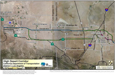 In March 2011, it was reported that Metro is planning to construct a brand
new 63-mile east-west freeway between Route 14 in Los Angeles County and
Route 18 in San Bernardino County. It would create a shortcut for goods
movement from the Central Valley to the rest of the United States and trim
back goods congestion through the L.A. basin. The proposed freeway would
replace long stretches of existing Route 138 and Route 18, which are
two-lane roads across open desert with notoriously-high fatality rates.
Current maps show the proposed Route 138 freeway branching off the
Antelope Valley (14) Freeway near Rancho Vista Boulevard. After skirting
northern Palmdale, it would curve south two miles, then head east to
Victorville along the Palmdale Boulevard alignment. It would join I-15 at
Stoddard Wells Road, north of the notorious weekend bottlenecks on I-15 at
Victorville and Hesperia. The one alternative route would loop the freeway
even further south, to run east and west along the existing alignment of
Route 138 at Pearblossom, and then east along Route 18 to Hesperia. The
center median of the proposed freeway is a possible roadbed for the
proposed "DesertXpress" high speed rail line that Las Vegas interests plan
to build between Las Vegas and Southern California. That line presently
would terminate in a giant parking lot at Victorville, but could be
extended down the new freeway 63 miles west to Palmdale. There, it would
connect to the proposed California High Speed Rail line to provide 200-mph
rail service between Las Vegas and downtown Los Angeles or San Francisco.
In March 2011, it was reported that Metro is planning to construct a brand
new 63-mile east-west freeway between Route 14 in Los Angeles County and
Route 18 in San Bernardino County. It would create a shortcut for goods
movement from the Central Valley to the rest of the United States and trim
back goods congestion through the L.A. basin. The proposed freeway would
replace long stretches of existing Route 138 and Route 18, which are
two-lane roads across open desert with notoriously-high fatality rates.
Current maps show the proposed Route 138 freeway branching off the
Antelope Valley (14) Freeway near Rancho Vista Boulevard. After skirting
northern Palmdale, it would curve south two miles, then head east to
Victorville along the Palmdale Boulevard alignment. It would join I-15 at
Stoddard Wells Road, north of the notorious weekend bottlenecks on I-15 at
Victorville and Hesperia. The one alternative route would loop the freeway
even further south, to run east and west along the existing alignment of
Route 138 at Pearblossom, and then east along Route 18 to Hesperia. The
center median of the proposed freeway is a possible roadbed for the
proposed "DesertXpress" high speed rail line that Las Vegas interests plan
to build between Las Vegas and Southern California. That line presently
would terminate in a giant parking lot at Victorville, but could be
extended down the new freeway 63 miles west to Palmdale. There, it would
connect to the proposed California High Speed Rail line to provide 200-mph
rail service between Las Vegas and downtown Los Angeles or San Francisco.
In November 2011, the LA Metro received a report looking at the various alternatives regarding the corridor, which proposes a new 63-mile freeway from Palmdale to Route 18 in San Bernardino. Metro staff has recommended variations along the corridor for further analysis in order to avoid, minimize or mitigate environmental concerns. In addition, staff recommended no further study of having the project concentrate solely on improvements to Route 138, saying that the environmental costs are considered to be too high compared to the transportation benefit that would be achieved.
![[HDC Interactive Map]](maps/138-hdc-1208-full.jpg) In August 2012, it was reported that LA Metro planners and other agencies have announced a
website with maps of the project: https://www.metro.net/projects/high-desert-corridor/. The map is interactive,allowing viewers to post photos with comments and
even link to the map on social media sites such as Twitter and Facebook.
It allows one to see the specifics of each variation, the proposed on- and
off-ramps, the physical variations, and the communities along the route.
The map makes clear that the HDC is not the same route as Route 18 or
Route 238; it is unclear what the route will be designated when (if) it is
completed.
In August 2012, it was reported that LA Metro planners and other agencies have announced a
website with maps of the project: https://www.metro.net/projects/high-desert-corridor/. The map is interactive,allowing viewers to post photos with comments and
even link to the map on social media sites such as Twitter and Facebook.
It allows one to see the specifics of each variation, the proposed on- and
off-ramps, the physical variations, and the communities along the route.
The map makes clear that the HDC is not the same route as Route 18 or
Route 238; it is unclear what the route will be designated when (if) it is
completed.
In July 2013, LAMTA and Caltrans unveiled various concepts for the
proposed High Desert Corridor from the Antelope Valley to San Bernardino
County that would allow travelers to bypass some of the busiest freeways
in Los Angeles County, and potentially link the California High Speed Rail
project to Las Vegas. The proposed corridor would stretch 63 miles from
east to west across Palmdale, Lancaster, Adelanto, Victorville as well as
the town of Apple Valley. Planners are considering a freeway only or a
freeway and railway that would connect to the California High Speed Rail
system, which is envisioned someday to span the length of the state, and
to the XpressWest bullet train from Victorville to Las Vegas. Currently,
there is only funding available to finish the environmental review in 2014
and nothing else. Aside from public-private partnerships, Metro and
Caltrans plan to seek state and federal funding for the project.
(Source: LA Daily News, 7/10/13)
In September 2014, it was announced that the draft EIR was completed and posted for review. There were five options presented: Freeway/Expressway Alternative, Freeway/Tollway Alternative, Freeway/Expressway with High Speed Rail (HSR) Feeder Service Alternative, Freeway/Tollway with HSR Feeder Service Alternative, and the No Build Alternative. The project is divided into three segments, including the Antelope Valley Segment (Route 14 to 100th Street East), the High Desert Segment (100th Street East to US 395), and the Victor Valley Segment (US 395 to Route 18). Recognizing it as a multipurpose corridor with potential to connect to the expanding regional rail system, the project may include a center-median HSR feeder service between Palmdale and Victorville. In addition, bicycle facility and green energy components would be incorporated into the design features of all alternatives of the corridor. Other alternatives, including a Transportation System Management (TSM) plan and Hybrid Alternative were studied and dropped from consideration. The basic freeway/expressway alternative would construct a combination of a controlled-access freeway and at-grade expressway for a total distance of 63 miles. The corridor from Route 14 to US 395 would be 500 feet wide and from US 395 to Route 18 would be 300 feet wide. The alignment generally follows Avenue P-8 in Los Angeles County and then runs slightly south of El Mirage Road in San Bernardino County. The alignment then extends to Air Expressway Road near I-15 and curves slightly southeast to terminate at Bear Valley Road near Apple Valley. There were four alignment variations considered: (A) Near Palmdale, the freeway/expressway would dip slightly south of the main alignment, approximately between 15th Street East and Little Rock Wash; (B/B1) East of the county line, the freeway/expressway would flare out slightly south of the main alignment between Oasis Road and Coughlin Road; (D) Near the community of Lake Los Angeles, the freeway/expressway would dip slightly south of the main alignment, just south of Avenue R, approximately between 180th Street East and 230th Street East; and (E) Near Adelanto and Victorville, the freeway/expressway would dip south of the federal prison. The tollway approach would use the same route; the segment where toll lanes are proposed, four in each direction, would begin from 100th Street East in Palmdale and end at US 395 in Victorville. The Central Segment would consist of a toll facility, and motorists who choose not to use this segment of the HDC would have the option to exit and use local west-east parallel roads adjacent to the HDC and reenter the freeway segments from either 90th Street East in Palmdale or US 395 in Adelanto. Each toll lane would be 12 feet wide. Other variations incorporate rail along approximately the same corridor.
In March 2016, the Los Angeles MTA presented its full proposal for what
transit lines could be built -- and when -- if Los Angeles County voters
approve a half-cent sales tax increase in November 2016. This proposal
included right of way funding for the High Desert Corridor: "The project
extends from Route 14 in LA County to Route 18 in San Bernardino County.
It consists of 4 components: Freeway (Route 14 to 100th St.: up to 4
mixed-flow lanes in each direction and from 100th St. to Route 18: 3
mixed-flow lanes in each direction), High Speed Rail connection between CA HSR in Palmdale and XpressWest in Victorville, Energy corridor that runs
parallel to the freeway, and bicycle component along the entire freeway.
From east to west, respectively; first 10 miles and last 10 miles will be
non-tolled; the middle 30 miles will be tolled."
(Source: Los Angeles Times 3/18/2016; Metro Board Report 3/24/2016)
In June 2016, it was noted that the environmental documents for the HDC
would be released June 20, 2016. The final alignment of the corridor's
route, expected to connect Palmdale with the Route 18/Bear Valley Road
intersection in Apple Valley, had been initially planned to be released
last July with the environmental reports due in September 2015, but those
plans were pushed back after a few at-risk animals were identified, a
consultant to San Bernardino County 1st District Supervisor Robert
Lovingood told the Daily Press in April 2015.
(Source: Desert Dispatch, 6/14/2016)
In February 2018, it was reported that the California Department of
Transportation, in cooperation with a joint powers authority, will in June
begin buying land to build a 63-mile high desert freeway connecting the
Los Angeles County communities of Palmdale and Lancaster with the San
Bernardino County communities of Victorville, Apple Valley and Adelanto.
Officials say the $8-billion project north of the San Gabriel and San
Bernardino mountains would relieve anticipated traffic congestion in the
fast-growing region by creating a link between Route 14 and I-15, and
reduce gridlock on Los Angeles-area roads including the I-210, I-10 and
Route 60 freeways. The freeway would be part of a High Desert Corridor
with a rapid-transit rail, linking to a proposed high-speed rail to Las
Vegas, and a bikeway. Funded with public-private partnerships, it could be
in operation within 20 years. The environmental impact report has already
been approved, paving the way for right of way agents to begin acquiring
land this spring with $274 million generated by Measure M. There are
concerns about the route. It passes through an area that is part of an
arid empire of Joshua trees, cactus, bobcats, tortoises and kangaroo rats
hemmed by steep slopes, dry lakes and arroyos fringed with creosote bush.
There is concern that it would destroy some of our last open space to
create more suburban sprawl, undermining efforts to reduce congestion and
making climate goals a farce. However, the most serious obstacles in the
path of the project seem to be financial. How or when San Bernardino
County would be able to pay for its stretch of right of way, which must be
500 feet wide in order to accommodate the freeway and rail, hasn’t
been settled. The route would run roughly parallel to Route 18 and Route 138, also known as Pearblossom Highway. Congestion is a problem on Route 138 thanks to big rigs, commuters and travelers to Las Vegas.
(Source: LA Times, 2/10/2018)
In October 2019, it was reported that in September 2019, the California
Department of Transportation agreed to shelve plans for the first new
freeway in Los Angeles County in more than a quarter-century. The 63-mile
High Desert Corridor freeway was designed as a new route, up to eight
lanes wide, to speed travelers and trade between Palmdale and San
Bernardino County’s Apple Valley. Although proponents rebranded the
High Desert Corridor as an innovative multimodal transportation
initiative, complete with a train line, a bike route and renewable energy
transmission facilities, its centerpiece until recently was still the
freeway. But the project raised many serious questions. The Los
Angeles-based nonprofit Climate Resolve sued in 2016 to block the freeway,
arguing that Caltrans didn’t adequately address the potential
contribution to global warming. Projections showed the route would have
resulted in 4 million additional miles being driven every day, at a time
when California has to slash the number of vehicle miles traveled to
reduce greenhouse gas emissions. Under the agreement with Climate Resolve,
Caltrans cannot begin work on the freeway without completing a lengthy
supplemental environmental impact report. But in reality, the agency has
no intention of doing the study or moving forward on the freeway in the
near future. The freeway was put on hold before the lawsuit was settled.
There wasn’t enough demand to justify building it, nor was there
funding to pay for it. Instead, Caltrans is looking at widening existing
roadways to handle the area’s traffic needs. Other elements of the
High Desert Corridor — including plans for an electric high-speed
train and bike route — can go ahead without additional environmental
study. The Measure M sales tax increase approved in 2017 included $1.8
billion for the High Desert Corridor, which could still be used for the
high-speed rail component.
(Source: LA Times, 10/6/2019)
In August 2020, it was reported that the Metro Board will consider
programming monies slated for the now-canceled High Desert Corridor
freeway to instead study building rail there. The 63-mile High Desert
Corridor freeway was planned to connect Palmdale, in north L.A. County, to
Victorville, in San Bernardino County. The corridor is split between those
two counties. Metro’s Measure M sales tax expenditure plan includes
“High Desert multi-purpose corridor” funding for the L.A.
County portion: $170 million already available and slated for property
acquisition, plus $1.8 billion for construction, scheduled for 2063-2067.
Those moneys could now shift from freeway to high-speed rail. The rail
connection has become more timely, with more than a hundred miles of
California High-Speed Rail under construction in the Central Valley and
XpressWest high-speed rail from Victorville to Las Vegas also moving
forward. The High Desert Corridor would close a gap in the state’s
high-speed rail network, allowing the system’s Los Angeles to Bay
Area north-south spine to branch out connecting east to Las Vegas. The
Metro proposal would program $3 million in Measure M funds for a $5
million study of High Desert Corridor rail. Also funding the study are a
$1,375,000 California Transit Intercity Rail Capital Program (TIRCP) grant
that Metro was awarded in 2018, and $250,000 (plus $375,000 in in-kind
services) from DesertXpress Enterprises, LLC (Virgin Train USA.) If
approved, the $5 million would complete a High Desert Intercity Rail
(HDIR) Corridor Service Development Plan. For the plan, Metro would
partner with DesertXpress, California State Transportation Agency (CalSTA)
and coordinate with the High Desert Corridor Joint Powers Authority, San
Bernardino County Transportation Authority, and the cities of Victorville,
Adelanto, Apple Valley, Palmdale and Lancaster.
(Source: Streetsblog LA, 8/19/2020)
Naming"Palmdale" Blvd; "Fort Tejon" Road; "Antelope" Highway.
 The portion of Route 138 in the County of Los Angeles from the interchange at Route 14 to
40th Street East in the City of Palmdale (~ LA 43.544 to LA 47.811) is
named the "Larry Chimbole Memorial Highway" (signed as "First
Mayor of Palmdale Larry Chimbole Memorial Highway"). Lawrence
“Larry” Chimbole was born in New Haven, Connecticut, in May
1919, and graduated from Stamford High School in 1937. During World War
II, Chimbole served as a B-29 radio operator in the Army Air Corps on the
Pacific Island of Tinian. After World War II, he moved to California and
settled in the City of Glendale, before migrating west to the San Fernando
Valley, and then moving to the community of Palmdale in 1957. When Larry
arrived in the Palmdale area, the population was approximately 7,100
people. There was no incorporated City of Palmdale or City of Lancaster,
no Antelope Valley Freeway, no California Aqueduct, no Antelope Valley,
Crystalaire, or Rancho Vista country clubs, no mall, no high schools, no
courthouse, no Board of Trade, no county library, no hospital, no Palmdale
Amphitheater, no DryTown Water Park, no Poncitlán Square, and no
Palmdale Auto Mall. Larry became the owner of a hardware store in Palmdale
and almost immediately became involved in Palmdale’s civic affairs
as president of the Palmdale Kiwanis Club, and then as president of the
Palmdale Chamber of Commerce in 1961. Larry was instrumental in leading
the City of Palmdale into incorporation as one of the “50 Grand
Men,” who each donated money to fund the process. After the city was
successfully incorporated in 1962, he was elected as the city’s
first mayor. He helped bring the Lockheed assembly plant to the Antelope
Valley and was instrumental in the development of the Antelope Valley and
its freeway system. After serving as mayor, Larry Chimbole ran as a
Democrat in a highly Republican area, went on to serve two consecutive
terms in the California State Assembly from 1974 to 1978, and was the
first Antelope Valley resident to ever be elected to the State
Legislature. He then served a total of 12 years on the Palmdale City
Council, where he represented the city as the president of the California
Contract Cities Association and as president of the Los Angeles County
Division of the League of California Cities. In 1974, Larry was
responsible for arranging the National Guard Armory to be located in the
City of Palmdale instead of the City of Lancaster. After serving in the
Assembly, Larry Chimbole continued to serve his community by serving as a
member of the State Board of Landscape Architects, the Antelope Valley
Healthcare District Board of Directors, and the Antelope Valley Fair Board
of Directors. In 1996, the Desert Mailer had the front page headline,
“Chimbole just keeps on tickin’.” In the article, when
asked how he would like to be remembered, Larry Chimbole stated that his
legacy would be how active he was in 1960 and that he remained just as
active for the rest of his life. Former Mayor Chimbole continued to be
active in his community. In 1999, he served as campaign chair of the
United Way Antelope Valley Region. In 2006, city officials immortalized
the “50 Grand Men” when they formally presented a beautiful
plaque that is currently on display at the Chimbole Cultural Center. On
August 24, 2012, Larry Chimbole was a featured guest at the City of
Palmdale’s 50th anniversary celebration held at Poncitlán
Square that was attended by thousands. In 2013, more than 100 friends and
family members gathered to celebrate his 94th birthday at the Chimbole
Cultural Center that bears his name. At 94, Larry Chimbole was still very
active in the community, where he attended many local community events. In
2014, a committee was formed to raise funds to create a series of bronze
statues called “Legendary Locals.” The first statue in the
series was to be of Larry Chimbole. The statue was dedicated on October 8,
2015, across from the Palmdale City Hall on a bench in Poncitlán
Square. More than 200 people witnessed the unveiling of the statue
entitled “The First Mayor,” which depicts Chimbole seated on a
bench with one arm resting atop the back of the bench to encourage
visitors to sit and visit with a “local legend”. Named by
Assembly Concurrent Resolution (ACR) 138, Res. Chapter 160, Statutes of
2016 on September 1, 2016.
The portion of Route 138 in the County of Los Angeles from the interchange at Route 14 to
40th Street East in the City of Palmdale (~ LA 43.544 to LA 47.811) is
named the "Larry Chimbole Memorial Highway" (signed as "First
Mayor of Palmdale Larry Chimbole Memorial Highway"). Lawrence
“Larry” Chimbole was born in New Haven, Connecticut, in May
1919, and graduated from Stamford High School in 1937. During World War
II, Chimbole served as a B-29 radio operator in the Army Air Corps on the
Pacific Island of Tinian. After World War II, he moved to California and
settled in the City of Glendale, before migrating west to the San Fernando
Valley, and then moving to the community of Palmdale in 1957. When Larry
arrived in the Palmdale area, the population was approximately 7,100
people. There was no incorporated City of Palmdale or City of Lancaster,
no Antelope Valley Freeway, no California Aqueduct, no Antelope Valley,
Crystalaire, or Rancho Vista country clubs, no mall, no high schools, no
courthouse, no Board of Trade, no county library, no hospital, no Palmdale
Amphitheater, no DryTown Water Park, no Poncitlán Square, and no
Palmdale Auto Mall. Larry became the owner of a hardware store in Palmdale
and almost immediately became involved in Palmdale’s civic affairs
as president of the Palmdale Kiwanis Club, and then as president of the
Palmdale Chamber of Commerce in 1961. Larry was instrumental in leading
the City of Palmdale into incorporation as one of the “50 Grand
Men,” who each donated money to fund the process. After the city was
successfully incorporated in 1962, he was elected as the city’s
first mayor. He helped bring the Lockheed assembly plant to the Antelope
Valley and was instrumental in the development of the Antelope Valley and
its freeway system. After serving as mayor, Larry Chimbole ran as a
Democrat in a highly Republican area, went on to serve two consecutive
terms in the California State Assembly from 1974 to 1978, and was the
first Antelope Valley resident to ever be elected to the State
Legislature. He then served a total of 12 years on the Palmdale City
Council, where he represented the city as the president of the California
Contract Cities Association and as president of the Los Angeles County
Division of the League of California Cities. In 1974, Larry was
responsible for arranging the National Guard Armory to be located in the
City of Palmdale instead of the City of Lancaster. After serving in the
Assembly, Larry Chimbole continued to serve his community by serving as a
member of the State Board of Landscape Architects, the Antelope Valley
Healthcare District Board of Directors, and the Antelope Valley Fair Board
of Directors. In 1996, the Desert Mailer had the front page headline,
“Chimbole just keeps on tickin’.” In the article, when
asked how he would like to be remembered, Larry Chimbole stated that his
legacy would be how active he was in 1960 and that he remained just as
active for the rest of his life. Former Mayor Chimbole continued to be
active in his community. In 1999, he served as campaign chair of the
United Way Antelope Valley Region. In 2006, city officials immortalized
the “50 Grand Men” when they formally presented a beautiful
plaque that is currently on display at the Chimbole Cultural Center. On
August 24, 2012, Larry Chimbole was a featured guest at the City of
Palmdale’s 50th anniversary celebration held at Poncitlán
Square that was attended by thousands. In 2013, more than 100 friends and
family members gathered to celebrate his 94th birthday at the Chimbole
Cultural Center that bears his name. At 94, Larry Chimbole was still very
active in the community, where he attended many local community events. In
2014, a committee was formed to raise funds to create a series of bronze
statues called “Legendary Locals.” The first statue in the
series was to be of Larry Chimbole. The statue was dedicated on October 8,
2015, across from the Palmdale City Hall on a bench in Poncitlán
Square. More than 200 people witnessed the unveiling of the statue
entitled “The First Mayor,” which depicts Chimbole seated on a
bench with one arm resting atop the back of the bench to encourage
visitors to sit and visit with a “local legend”. Named by
Assembly Concurrent Resolution (ACR) 138, Res. Chapter 160, Statutes of
2016 on September 1, 2016.
(Image source: Steve Knight on Twitter; Daily News)
 Portions are known as the Pearblossom Highway or Pear Blossom Highway (~ LA 51.486 to LA 69.319).
Pearblossom refers to the community of Pearblossom, which was named by Guy
Chase for its once abundant pear orchards. The orchards died off in
blight. This was named in April 1926 by the Los Angeles County
Supervisors, for recorded "Pear Blossom Highway" as the official name of
the thirty-mile road now connecting Palmdale with the County Park
(Swartout Valley was then known as the Los Angeles County Park) and
formally opened this Antelope Valley route from Los Angeles to the park.
Portions are known as the Pearblossom Highway or Pear Blossom Highway (~ LA 51.486 to LA 69.319).
Pearblossom refers to the community of Pearblossom, which was named by Guy
Chase for its once abundant pear orchards. The orchards died off in
blight. This was named in April 1926 by the Los Angeles County
Supervisors, for recorded "Pear Blossom Highway" as the official name of
the thirty-mile road now connecting Palmdale with the County Park
(Swartout Valley was then known as the Los Angeles County Park) and
formally opened this Antelope Valley route from Los Angeles to the park.
(Image source: Realtor.Com; Pixabay)
 The portion from 136th Avenue to 195th Avenue (~ LA 60.698 to LA 66.868) is named the "Deputy
Sheriff Steven Sorensen Memorial Highway". It was named in memory of
Deputy Sheriff Stephen Sorensen of the Los Angeles County Sheriff's
Department, who was killed in the line of duty on August 2, 2003, in
Llano, while responding to a routine trespassing investigation on his "day
off". Deputy Sorensen, who was known as the "town sheriff", was the
resident deputy for the Lake Los Angeles area and patrolled several
sparsely populated communities at the edge of the Mojave Desert. He was
the only full-time deputy responsible for 150 square miles. Deputy
Sorensen was renowned for working to better the community and for helping
the people living there and performed his duty not for press or glory but
for the betterment of his community. Named by Assembly Concurrent
Resolution 135, Chapter 42, May 3, 2004.
The portion from 136th Avenue to 195th Avenue (~ LA 60.698 to LA 66.868) is named the "Deputy
Sheriff Steven Sorensen Memorial Highway". It was named in memory of
Deputy Sheriff Stephen Sorensen of the Los Angeles County Sheriff's
Department, who was killed in the line of duty on August 2, 2003, in
Llano, while responding to a routine trespassing investigation on his "day
off". Deputy Sorensen, who was known as the "town sheriff", was the
resident deputy for the Lake Los Angeles area and patrolled several
sparsely populated communities at the edge of the Mojave Desert. He was
the only full-time deputy responsible for 150 square miles. Deputy
Sorensen was renowned for working to better the community and for helping
the people living there and performed his duty not for press or glory but
for the betterment of his community. Named by Assembly Concurrent
Resolution 135, Chapter 42, May 3, 2004.
(Image source: Santa Clarita Valley Sheriff's FB Page)
 The portion of Route 138 from Kruse
Road to Lone Pine Canyon Road (~ SBD 11.766 to SBD 13.982) is named the "Abiel
Barron Memorial Highway". This segment was named in memory of Los
Angeles Police Department Detective Abiel Barron who was killed in the
line of duty during the evening hours of June 25, 2003. Detective Barron
was conducting a follow-up investigation in the Palmdale/Lancaster area
and was traveling on Route 138 near its junction with I-15 at Mormon Rocks
when a driver attempting to pass slower moving vehicles on the two-lane
highway collided head-on with Detective Barron's police vehicle. Detective
Barron succumbed to injuries as a result of the collision. Abiel Barron
began his career with the Los Angeles Police Department after graduating
from the police academy in 1983, and after successfully completing
probation was assigned to field duties in Newton Street Division in South
Los Angeles. He made significant contributions to public safety while
assigned to the Newton Street Division for the next 12 years. He was
promoted to the rank of detective in 1995 and served in the capacity of an
investigator in the Los Angeles Police Department's Gun Detail. After
successfully completing his detective probationary period, Detective
Barron returned to his assignment of choice, that of a homicide
investigator in the Newton Street Division. In this capacity, he provided
distinguished service to that community until he attained a new assignment
as a detective at the Los Angeles Police Department's northeast area in
2000. He then continued to serve with distinction as a sex crimes
investigator until his assignment to the Northeast Area homicide detail in
2001. He continued as a homicide investigator in 2002, and was nominated
for an award for bravery in saving the life of a despondent woman
attempting to commit suicide by jumping from a bridge at the Los Angeles
River. Detective Barron was awarded the Los Angeles Police Department's
"Police Medal" for bravery that was presented to his wife posthumously.
Named by Assembly Concurrent Resolution (ACR) 5, Resolution Chapter 64, on
07/07/2005.
The portion of Route 138 from Kruse
Road to Lone Pine Canyon Road (~ SBD 11.766 to SBD 13.982) is named the "Abiel
Barron Memorial Highway". This segment was named in memory of Los
Angeles Police Department Detective Abiel Barron who was killed in the
line of duty during the evening hours of June 25, 2003. Detective Barron
was conducting a follow-up investigation in the Palmdale/Lancaster area
and was traveling on Route 138 near its junction with I-15 at Mormon Rocks
when a driver attempting to pass slower moving vehicles on the two-lane
highway collided head-on with Detective Barron's police vehicle. Detective
Barron succumbed to injuries as a result of the collision. Abiel Barron
began his career with the Los Angeles Police Department after graduating
from the police academy in 1983, and after successfully completing
probation was assigned to field duties in Newton Street Division in South
Los Angeles. He made significant contributions to public safety while
assigned to the Newton Street Division for the next 12 years. He was
promoted to the rank of detective in 1995 and served in the capacity of an
investigator in the Los Angeles Police Department's Gun Detail. After
successfully completing his detective probationary period, Detective
Barron returned to his assignment of choice, that of a homicide
investigator in the Newton Street Division. In this capacity, he provided
distinguished service to that community until he attained a new assignment
as a detective at the Los Angeles Police Department's northeast area in
2000. He then continued to serve with distinction as a sex crimes
investigator until his assignment to the Northeast Area homicide detail in
2001. He continued as a homicide investigator in 2002, and was nominated
for an award for bravery in saving the life of a despondent woman
attempting to commit suicide by jumping from a bridge at the Los Angeles
River. Detective Barron was awarded the Los Angeles Police Department's
"Police Medal" for bravery that was presented to his wife posthumously.
Named by Assembly Concurrent Resolution (ACR) 5, Resolution Chapter 64, on
07/07/2005.
(Image Source: LAPD "The Beat" 5/2007; LAPD Communications Division FB Page)
 Double Fine Zones
Between the intersection with Avenue T and Pearblossom Highway and Route 15. Authorized by Senate Bill 155, Chapter 169, on July 23, 1999.
 Freeway
[SHC 253.7] From Route 5 near Gorman to Route 15 near Cajon Pass. Added to the Freeway and Expressway system in 1959.
 Scenic Route
 Interregional Route
 Other WWW Links
 Statistics
Overall statistics for Route 138 (this reflects information from before the 1995 transferrence of Route 48 between Route 138 and Lancaster to Route 138, and the deletion of the routing to Palmdale):
Significant Summits: Mountain Summit (4804 ft)
 Pre-1964 Legislative Route
In 1913, Chapter 610 declared and established a state highway from the city of Bakersfield through a portion of the counties of Kern, San Luis Obispo, Santa Barbara and Ventura to the city of San Buenaventura, to be designated and known as the "Bakersfield, Maricopa and Ventura state highway." This highway was referenced as:
"A certain highway now partly constructed and partly in the course of construction by the several counties through which the same passes and running substantially along the following lines, courses, and distances: Commencing at a point on the proposed California state highway between Bakersfield and Los Angeles [LRN 4] thence following the present county road W 6 mi, then S 12 mi, thence W ½ mi, thence S ¾ mi, thence W 8 mi, thence SW 4 mi, thence W 5 mi to the town limits of the city of Maricopa, thence ... SW 13 miles to the W boundary of Kern County..., thence from a junction at the Kern Cty line with the proposed road as surveyed by Buffington ... for a distance of approx. 5 mi in the county of San Luis Obispo W about 1 mi through the lands of the Kern Cty Land Company and Cuyama Ranch, thence SW-ly 1½ mi, thence E-ly ¾ mi, thence SE-ly about 1 mi through the lands of the Santa Barbara Forest Reserve and of S.B. Miller, said line of proposed road ... following along the E-ly side of the Cuyama River and in the valley of said Cuyama river to the S border of SLO Cty. Thence from a junction point ... being in Sec. 11 T9N R25W SBM and running in a generally SE-ly direction, following the valley of the Cuyama river for a distance of 8.1 mi to a point in the E boundary of Santa Barbara Cty in Sec 17 T8N R24W SBM. Thence from ... the W boundary of Ventura Cty in the valley of the Cuyama River...beginning at a point in Sec 17 T8 R24W SBM approx. 1100 ft S of the N boundary of Sec 17, thence SE-ly along the NE bank of the Cuyama river a distance of 10 mi to a point near the center of Sec 19 T7N R23W on the S-ly bank of the Cuyama river thence E about ¾ mi to a point in the W half of Sec 20 T7N R23W, thence S through the W half of the W half of Sec 20 T7N R23W, and the W half of the W half of Sec 29 T7N R23W on the E side of Boulder Cyn, thence S on the W side of Boulder Cyn through the E half of the SE qtr of Sec 30 and the W half of Sec 32 T7N R23W, thence SW passing the great saddle rock to a point on the summit of Pine Mtn at the quarter corner between Sec 5 and 6, T6N R23W, thence S along the W side of Chorro Chiquito Cyn through Sec 6, 7, 8 and 18 T6N R23W to the valley of the Sespe River, thence crossing the Sespe River and S up the E side of Cherry Ck Cyn through Sec 19, 30, and 31 T6N R23W to the summit of Ortega Hill in Sec 31 T6N R23W, thence from the top of Ortega Hill and following along the Wheeler Ridge passing through the SW corner of Sec 32 T6N R23W, through the NE corner of Sec 1 T5N R24W, through the center of Sec 6 T5N R23W, to the SE corner of Sec 5 T6N R23W, thence S through Sections 8 and 9 T6N R23W, to a point near the ¼ corner on the S side of Sec 8 T5N R23W, to a point in the Matilja Rd near the Matilja Hot Springs in said Sec 29.... thence SE-ly with the Matilja and Meiners Rds ... to the town of Nordhoff ... thence S-ly with the San Antonio Crk Rd, the Nordhoff Rd, and the Ventura Avene to the N-ly limits of San Buenaventura."
In 1929, Chapter 541 amended this definition to be:
“…is amended to read as follows: A certain highway now partly constructed by the several counties through which the same passes and by joint highway district number six of the State of California and running substantially along the following lines: Commencing at a point in the Cuyama river valley on the state highway running between Santa Maria, Maricopa, and Bakersfield, and known as [LRN 57] of the state highway system, and running thence SE-ly up the Cuyama river valley to a point in Ventura County; thence S-ly over the Coast Range mountains and through the Santa Barbara national forest to Matilja Hot Springs; thence SE-ly to the city of San Buenaventura. The entire length from San Buenaventura (Ventura) to [LRN 57] of the state highway in the Cuyama valley is hereby declared to be, and is hereby constituted, a state highway... provided that said highway shall not become a state highway ... until said highway shall have been fully completed.”
However, both were repealed in 1935 by the act that created the highway code. In 1915, Chapter 748 did something similar, with an act for the survey, location, and estimate of cost of a state highway from a point on the present located state highway in Kern County S of Bakersfield to the town of Nordhoff, Ventura County. Again, this was repealed in 1935 by the act that created the highway code. It is possible these early routes were LRN 57, but portions may have shown up in the eventual definition of LRN 138 in 1933.
Chapter 767 in 1933 provides a clearer origin, for it defined the following segments as part of the highway system:
In 1935, the state highway code was created, and it defined LRN 138 as follows:
In 1955, Chapter 1912 extended LRN 138 and reworked the definition to be:
This route is signed as follows:
This is a portion of Route 33, but parts of the routing could also be considered part of I-5.
This is present-day Route 33; before 1964, it was signed as Route 33 between Route 198 near Coalinga and present-day Route 119 (former US 399) near Taft, and as US 399 from Taft to Route 166 near Maricopa.
This segment was signed as US 399. It is part of present-day Route 33.
© 1996-2020 Daniel P. Faigin.
Maintained by: Daniel P. Faigin
<webmaster@cahighways.org>.
 Route 137
 Route 139