
 California Highways:
Click here for a key to the symbols used. An explanation of acronyms may be found at the bottom of the page.
 Routing
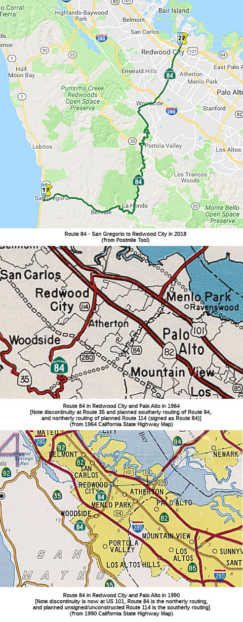 From Route 1 near San Gregorio to Route 101 at Woodside Road in Redwood City.
 Post 1964 Signage History
In 1963, this segment was covered by the first two segments of the definition: "(a) Route 1 to Route 35. (b) Route 35 to Route 238."
In 1984, Chapter 409 rewrote segments (a) and (b) and relocated the discontinuity to US 101, making this segment the new (a): "(a) Route 1 near San Gregorio to Route 101 at Woodside Road in Redwood City. (b) Route 101 at Marsh Road in Menlo Park to Route 238."
The first signage in the field was noted in 1963. According to Scott
Parker on AARoads:
(Source: Scott Parker (Sparker) on AARoads, "Re: CA 84", 5/17/2019)
[In the Summer of 1963] freestanding trailblazer signage marked the Willow Ave. interchange; essentially "tacked on" besides the original street big green or black signs. Route 84 (new-style white) reassurance shields were indeed mounted beneath the Bypass US 101 reassurance shields north as far as the Old Bayshore Highway exit in Redwood City -- the east Woodside Road extension was still in the planning stages. The original alignment of Route 84 (LRN 107) was northwest along Old Bayshore Highway to Main Street, where it turned on a very sharp angle SSW, crossing then-US 101 (LRN 2, later Route 82) and veering a bit to the right as Woodside Road. Again, the Bypass 101/Old Bayshore exit for Route 84 was marked, like the Willow interchange, with freestanding white Route 84 trailblazer signage. Post '64 renumbering, Route 84 was indeed planned to follow the San Francisquito Creek southwest, essentially subsuming the Sand Hill Road alignment up to near the intersection of Portola Road and La Honda Road, where it would head uphill to Route 35 and then down along the current alignment to its terminus at Route 1 near La Honda. The original Route 114 was what is now Route 84 west of US 101 -- down Woodside Road to I-280, where the legal definition of Route 114 ended. After Stanford balked at allowing another major highway on its grounds (it too would have skirted the linear accelerator), the numerical definition was swapped circa 1976, with Route 84 formally assigned to its current Woodside Road and La Honda Road alignment, and Route 114 relegated to a line on the map now ending at Route 82 at the Santa Clara/San Mateo county line (between Palo Alto and Menlo Park). When Route 84 was rerouted over the Bayfront Expressway from Willow Road NW to the Marsh Road/US 101 interchange in the '90's, Willow Ave. from US 101 to Route 84 was ceded to Route 114 (and even signed with trailblazers at US 101 for a short time). But any extension west of US 101 has been functionally dead for decades. Route 114/Willow Road is now famous/notorious as the street where Facebook HQ is located. But since the relinquishment of Route 84 in Fremont has been announced, the designated west segment of Route 84 is now in 2 parts: from Route 1 in La Honda to US 101 in Redwood City, and from US 101 at the Marsh Road exit to I-880 at Decoto Road in Newark.
 In July 1964, the Highway Commission adopted a 1.7 mi freeway location for Route 84 between
the adopted route for I-280 and Santa Cruz Avenue in Menlo Park, following
the general alignment of Sand Hill Road. The requirement was that this
freeway comply with the master plan for scenic highways. The alternative
considered was a routing along Alpine Road. San Mateo and Santa Clara
preferred the Sand Hill routing; Palo Alto favored Alpine Road. Stanford
opposed the Alpine Route. Note that this routing was later renumbered as
Route 114, and then the segment between I-280 and US 101 was deleted from
the Route 114 definition.
In July 1964, the Highway Commission adopted a 1.7 mi freeway location for Route 84 between
the adopted route for I-280 and Santa Cruz Avenue in Menlo Park, following
the general alignment of Sand Hill Road. The requirement was that this
freeway comply with the master plan for scenic highways. The alternative
considered was a routing along Alpine Road. San Mateo and Santa Clara
preferred the Sand Hill routing; Palo Alto favored Alpine Road. Stanford
opposed the Alpine Route. Note that this routing was later renumbered as
Route 114, and then the segment between I-280 and US 101 was deleted from
the Route 114 definition.
 Pre 1964 Signage History
Route 84 was not defined as part of the original set of state signed routes in 1934; it was defined by the highway commission in January 1961. This was an extension to LRN 107. By 1963, between Woodside and US 101, there were two alignments:
 Status
There are no local roads that fit the definition of a traversable local highway between Woodside Road and Marsh Road, according to the 2002 and 2013 Traversable Highways reports.. This was a San Mateo County Measure A project.
US 101 / Route 84 Project: Woodside Road Interchange (04-SM-101 4.6/6.5, 04-SM-84 25.3/25.721)
 In October 2015, it was reported that the San Mateo
County Transportation Authority allocated $2.65 million to help add
vehicle lanes, sidewalks and bikeways to the Woodside Road/US 101
interchange (~ 04-SM-101 5.264), as well as to expand and signalize the
ramp intersection, according to the report.
In October 2015, it was reported that the San Mateo
County Transportation Authority allocated $2.65 million to help add
vehicle lanes, sidewalks and bikeways to the Woodside Road/US 101
interchange (~ 04-SM-101 5.264), as well as to expand and signalize the
ramp intersection, according to the report.
(Source: San Mateo Daily Journal, 10/2/2015)
In July 2017, it was reported that a plan to ease
congestion at a Redwood City highway interchange moved into the design
phase this week. The City Council on Monday authorized staff to pay AECOM
Technical Services up to $7.9 million to design improvements for the US 101/Route 84 (Woodside Road) interchange, which involves widening Woodside
Road to add new lanes, building new ramps to and from US 101 and adding
sidewalks and bicycle lanes. The council also authorized paying Krupa
Consulting up to an additional $335,000 to continue managing the project.
The purpose of the project is to alleviate peak-hour congestion at the
interchange and reduce traffic at local street intersections of Woodside
Road with Veterans Boulevard, Broadway, Bay Road, Seaport Boulevard,
Blomquist Street and East Bayshore Road. The city, as sponsor of the
interchange project, is responsible for completing the first phase of
design, set to begin next month and continue through Aug. 31, 2019. AECOM
will design widening Woodside Road from four to six lanes, plus turn
pockets; lowering Woodside an additional 6 inches to boost vertical
clearance at the US 101 undercrossing to 15 feet; reconstructing ramp
connections between Woodside and US 101, replacing a northbound US 101
ramp to connect with Seaport at a new signalized intersection and
constructing flyover ramps between Veterans and US 101; eliminating the
five-legged intersection at Woodside and Broadway; adding a series of new
sidewalks and bike lanes throughout the project area; and adding
high-occupancy vehicle lanes to US 101 ramps. The project doesn’t
require the city to spend any funds out of its operating budget on the
design phase. The work is funded through the San Mateo County
Transportation Authority Highway Program Grant, which had a balance of
$8,044,880 as of May 31, and more than $1.5 million in traffic mitigation
fees collected from two commercial developments recently approved in the
Woodside corridor.
(Source: Mercury News, 7/26/2017)
The 2018 STIP, approved at the CTC March 2018 meeting, appears to allocate $8M in FY21-22 for R/W acquisition for PPNO 0692K, Rt 101/Woodside Rd Interchange improvements.
The 2020 STIP, approved at the CTC March 2020 meeting,
makes no changes to the programmed allocations for PPNO 0692K, Rt
101/Woodside Rd Interchange improvements.
(Source: March 2020 CTC Agenda, Item 4.7, 2020 STIP
Adopted 3/25/2020)
In May 2022, the CTC approved the following project for
future consideration of funding: 04-SM-101 4.6/6.5, 04-SM-84 25.3/25.721.
US 101 / Route 84 Project. Widen the interchange and other
improvements (ND) (PPNO 0692K) (STIP). The project is located on a
1.9-mile segment of US 101 and a 0.4-mile segment on Route 84 (Woodside
Road), and includes connection modifications to Veterans Boulevard,
Broadway Street, Bay Road, Seaport Boulevard, East Bayshore Road, and
Blomquist Road in Redwood City, San Mateo County. The project will
construct ramp connections to US 101, including direct-connect flyover
ramps between US 101 and Veterans Boulevard, install pedestrian and
bicycle facilities, improve the intersection at Woodside Road, and perform
connection modifications to adjoining streets. The Project is fully funded
through right of way acquisition with State Transportation Improvement
Program Funds ($8,000,000) and Local Funds ($65,450,000). Construction is
estimated to begin in Fiscal Year 2025-26.
(Source: May 2022 CTC Agenda, Agenda Item 2.2c.(5))
In May 2022, the CTC approved the following R/W STIP
allocation: $8,000,000. 04-SM-101 4.4/6.5. PPNO 04-0692K; ProjID
0414000032; EA 23536. US 101/Woodside Road Interchange Improvement
Project. US 101 In the city of Redwood City. Widen Woodside Road to
six lanes, construct turn pockets, and reconstruct all ramp connections
between Woodside Road and US 101 including construction of a flyover
ramp from northbound US 101 to Veterans Boulevard. Allocation: R/W
$8,000,000.
(Source: May 2022 CTC Agenda, Agenda Item 2.5c.(2)
#2)
In January 2024, Caltrans released the draft 2024 SHOPP, which contained
the following long-lead project: 04-San Mateo-84 19.89. PPNO 04-2916P;
ProjID 0421000276; EA 2W780. Route 84 In Woodside, at West Union Creek
Bridge № 35-0044. Widen bridge and upgrade bridge railing.
(Long Lead Project). Note: Due to project location being in the Santa Cruz
Mountain range over an existing creek and near the Pacific Ocean,
additional environmental requirements and mitigation is anticipated.
Proposed ($ × 1000): PA&ED: $1,885; PS&E: $3,010; R/W $1,085;
R/W Sup $869; Con $9,327; Con Sup: $3,725; Total: $19,901. Only PA&ED
phase is authorized. Begin Con: 1/1/2030.
(Source: 2024 Draft SHOPP v4.0, 1/31/2024)
 Route 101 at Marsh Road in Menlo Park to Route 880.
Post 1964 Signage HistoryIn 1963, this segment was covered by the original segment (b): "(b) Route 35 to Route 238."
In 1984, Chapter 409 rewrote segments (a) and (b) and relocated the discontinuity to US 101, making this segment the new (b): "(a) Route 1 near San Gregorio to Route 101 at Woodside Road in Redwood City. (b) Route 101 at Marsh Road in Menlo Park to Route 238."
In 1988, Chapter 106 split segment (b) and made the definition more specific: "(b) Route 101 at Marsh Road in Menlo Park to Route 880. (c) Route 880 to Route 238."
Before the reconstruction of the Dumbarton Bridge and the construction of the Newark bypass freeway between the east end of the bridge and I-880, Route 84 followed Thornton Avenue from Route 84 southeast to I-880.
In October 2005, the Governor signed AB 1462 which changes the existing law that authorized a city or county in which a planned transportation facility was to be located on Route 238 in Alameda County to develop and file with the California Transportation Commission a local alternative transportation program that addresses transportation problems and opportunities, and provides for the use of revenues from the sales of excess properties acquired for the planned state facility in order to fund the local alternative program, but limits the use of revenues from excess property sales to highway purposes. It also extends the applicability of the provision that the commission may not approve a local alternative program under these provisions after July 1, 2010 to a Route 84 between existing Route 238 and I-880 in Alameda County. (Chapter 619, October 6, 2005)
Pre 1964 Signage HistoryRoute 84 was not defined as part of the original set of state signed routes in 1934. This was LRN 107 (defined in 1933), and includes the Dunbarton Bridge. The route existed in 1939, but the signage is unclear. It was signed as Route 84 in 1961.
The Dunbarton Bridge was originally a rail bridge that opened in 1910,
the first bridge across the bay. The Dumbarton Rail Bridge was the
region’s very first bay crossing. It was declared “a great
engineering feat” for Southern Pacific Railroad engineers who
somehow managed to create a solid foundation over slimy, unstable
marshland. The bay tides were relentless, and it took builders three years
to complete the grueling project that would require 6,000 carloads of rock
to fill the bottom of the bay to support the bridge’s massive
weight. But $3.5 million later, 7,600 feet of steel and a trestle
connected Newark and Redwood City — signaling a new era for
transportation and growth without the use of those sluggish freight
ferries. The rail bridge continued to transfer freight trains from
Stockton into San Francisco for decades, until the early 1980s rolled
around and changed everything. The Rail Bridge still exists, just south of
the current auto bridge. It has been unused since 1982 but remains in
place, its swing span now permanently in the open position to allow ship
traffic. Money was part of the problem for why the Dumbarton Rail Bridge
became dormant. The San Mateo County Transportation Authority bought the
historic bridge in 1994, but funds to repurpose it were elusive. Four
years later, a mysterious fire engulfed the rail crossing, keeping
firefighters busy for three days until they were able to control the
inferno. Undeterred by the fire, SamTrans’ former vice
chairman, Mike Nevin, reassured that repurposing the bridge would someday
be a reality. “The important point is that we still have the right
of way and the concrete pilings to support any future structure are still
there,” Nevin told The San Francisco Chronicle in 1998. April Chan,
chief officer for the San Mateo Country Transportation Authority, said
that the future of the rail bridge has been put on hold since the pandemic
hit. Things have slowly moved along since Facebook invested $1 million in
2016 to study how the historic bridge could help ease traffic congestion.
Earlier in 2021, the social media company discussed the potential of using
a commuter rail or autonomous vehicles on the Dumbarton Rail Bridge,
though currently, no date has been attached to when the project may begin.
(Source: Mercury News, 1/17/2017; Gribblenation Blog:CaliforniaState
Route 84 west from Interstate 880 over the Dumbarton Bridge,
2/15/2019; SFGate, 11/19/2021)
In the mid-1920s, the Dumbarton Bridge Company, a private entity,
constructed a two-lane toll bridge parallel to the rail bridge. The first
cars drove across the automotive bridge on Jan. 17, 1927. The Bay Bridge
would not open until November 1936, and the Golden Gate Bridge six months
after that. The 1927 Dumbarton Bridge was similar to the 1929 San
Mateo-Hayward Bridge in that it featured a causeway structure and a center
vertical lift span. However, the 1927 bridge was riddled with problems
from the beginning. Its narrow two-lane design caused multiple car crashes
that were often fatal. Things got worse as the bridge aged. The roads had
become so bumpy that driving through the toll bridge was often compared to
a roller coaster by frustrated motorists. Drivers braced themselves on
particularly windy days when they needed to dodge drifting foam from the
salt ponds below. In 1951, the Dumbarton Bridge Company sold the bridge to
the California Division of Highways in 1951 for $2.25 million. The 1927
Dumbarton Bridge became part of LRN 107, which already existed on both
ends of the structure since 1933.
(Source: Mercury News, 1/17/2017; Gribblenation Blog:CaliforniaState
Route 84 west from Interstate 880 over the Dumbarton Bridge,
2/15/2019; SFGate, 11/19/2021)
The Alameda County Highway Advisory Committee urged the State Toll Bridge
Authority to replace the dilapidated structure in 1969, but funding a new
bay crossing wasn’t prioritized as it was up against BART.
Eventually, bonds to construct the present-day Dumbarton Bridge were
secured. The modern structure, complete with six lanes, towered over the
older toll bridge when it opened in 1982. The old bridge was demolished
two years later: just before 3 p.m. on Sept. 23, 1984, the 222-foot-long
main span of the old bridge went tumbling into the bay, after six hours of
delay. What the remaining 200 spectators saw was a bright flash from 176
explosive charges, a dark cloud of smoke and dust, and then the splash as
600 tons of debris fell into the water. The delay was the result of
numerous adjustments to make sure the towers on each side wouldn’t
be destroyed as well. Those towers and the eight other spans would be
taken down later.
(Source: Mercury News, 1/17/2017; Gribblenation Blog:CaliforniaState
Route 84 west from Interstate 880 over the Dumbarton Bridge,
2/15/2019; SFGate, 11/19/2021)
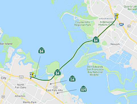
StatusThere were plans for a $60 million "Bayfront Expressway extension project" that would parallel US 101 between Marsh and Woodside roads (SM 25.621 to SM R25.857), but these have been put on hold. The existing Bayfront Expressway comes off the Dumbarton Bridge and runs north along the bay as far as Marsh Road. Current plans call for it to be extended to the next interchange, at Woodside Road (~ 84 SM 25.619). There has been a project to widen this segment, and it is now six lanes from the Dumbarton Bridge to the Marsh Road/US-101 interchange. The widening project was (remarkably) completed seven months ahead of schedule.
The portion of Route 84 from US-101/Marsh Road (~ SM R25.881) to the junction with Route 114 (Bayfront Expressway, ~ SM R25.999), is now signed as Route 84 (in addition to the Willow Road portion, which is really Route 114 but signed as Route 84). New signage along US 101 also points out that the Bayfront Expressway is now Route 84. In fact, at the Willow Road/Bayfront Expressway (~ 84 SM R27.623) junction, westbound Route 84 drivers are now directed to continue on Bayfront, instead of the older signed left turn down Willow/Route 114.
In June 2018, the CTC authorized an access control opening on Route 84 at
SM PM 27.2 in the city of Menlo Park, county of San Mateo. This request is
part of the Bayfront Expressway Roadway Improvement Project which will
improve traffic operation along Bayfront Expressway, also known as Route 84, in order to accommodate the additional traffic demand generated by
development on the adjacent Hibiscus Properties, LLC parcel. A traffic
study was completed in July 2017 to analyze traffic impacts to Bayfront
Expressway. The study identified installation of a signalized intersection
at the subject access opening location as the preferred alternative to
alleviate increased traffic volumes after development. The existing main
access would also be modified to allow westbound left turns for transit
buses only and extension of the existing eastbound right turn lane.
Director’s Deed (DD) 045626-01-04, approved May 17, 2018, authorized
the transfer of a 71.49 foot access control opening to Hibiscus
Properties, LLC. This break in access control will be of public benefit by
increasing traffic safety at the new intersection, better controlling the
flow of traffic, and reducing traffic queueing in this area. The cost of
all road improvements associated with this Project is borne by the
developer.The May, 2018 Commission meeting agenda item essentially sold a
04-SM-84 PM 27.2 a 71.49-foot access opening to HIBISCUS PROPERTIES, LLC
for $2,025,000 (Appraisal $2,025,000). This is a right of way
decertification of access restriction along Route 84, an access restricted
conventional highway. A full intersection will be constructed. The new
access opening is located on the southerly side of Route 84 between the
signalized intersections of Chilco Street and Willow Road in the city of
Menlo Park (City). The buyer, Hibiscus Properties LLC, is owned by
Facebook. Facebook is expanding their campus at this location and the City
requires the location of a new driveway off the highway, as Chilco Street
cannot accommodate the increase in traffic caused by the Facebook
expansion. Selling price represents appraised value.
(Source: CTC Agenda, June 2018 Agenda Item 4.20)
The SAFETEA-LU act, enacted in August 2005 as the reauthorization of TEA-21, provided the following expenditures on or near this route:
Dumbarton Bridge Toll
According to the San Jose Mercury News, there are plans in early 2009 to raise tolls on the Dumbarton Bridge, likely $1, and likely to be applied to carpoolers as well. They may also add congestion pricing. This is being done to help support the cost of retrofitting the Dumbarton and Antioch spans for earthquake improvements. In February 2010, the toll increased to $5 at all times on the Dumbarton, San Mateo, Richmond-San Rafael, Carquinez, Benicia-Martinez and Antioch bridges. In July 2010, the toll will be extended to carpoolers, who will pay $2.50.
In September 2019, it was reported that the
Metropolitan Transportation Commission gave the green light on a $4
million contract with a consultant for an all-electronic tolling system
for all bay area bridges, except the Golden Gate which is its own district
and has already gone cashless.. Drivers must pay with FasTrak only. For
those without FasTrak, cameras will capture your license plate and you'll
get a bill in the mall. The commission said it will save drivers time and
the agency money. Drivers won't have to slow down to squeeze through a
toll booth. Toll booths will be removed. The commission anticipates
realistically it could take up to five years for the system to go into
effect. The Carquinez Bridge will likely be the first to go cashless. MTC
said engineers say it's a good test bed to move faster on the others. The
Bay Bridge will be likely be last since it's the busiest. The toll
authority first authorized the move to all-electronic, open road tolling
in December 2018. The consultants jsut approved will be responsible for
developing the toll system’s specifications, providing oversight of
the program’s implementation, reviewing design plans, and help to
develop policies for all-electronic tolling. Bridges under the purview of
the toll authority include the Antioch Bridge, Benicia-Martinez Bridge,
Carquinez Bridge, Dumbarton Bridge, Richmond-San Rafael Bridge, San
Mateo-Hayward Bridge and the San Francisco-Oakland Bay Bridge.
(Source: KTVU, 9/1/2019; SFExaminer,
9/4/2019)
Dumbarton Bridge Retrofit (~ SM R28.989 to ~ ALA R3.112)
In July 2010, the Bay Area Toll Authority, which governs all of the region's toll bridges except the Golden Gate Bridge, allocated $75 million in toll money to fund construction of the Dumbarton Bridge retrofit. Caltrans plans to award the funds to a construction firm in August 2010. The winning contractor will begin working shortly thereafter, but no later than September, according to the toll authority. Officials expect to wrap up the project in April 2013, and the construction firm's contract will be tied to finishing the work quickly. The new Dumbarton span is being designed to withstand the most intense earthquake possible in the region. Work includes installing 14 steel pipe piles, replacing deck joints and strengthening the connections from the approaches to the bridge. Although the full cost of the Dumbarton project is budgeted at $365 million — to be funded using toll revenue — it is unlikely to be that high. Construction bids came in as low as $47 million after engineers budgeted $73 million because contractors continue to quote low prices around the Bay Area during the recession. The toll authority still plans to allocate $75 million to give Caltrans breathing room in awarding the contract.
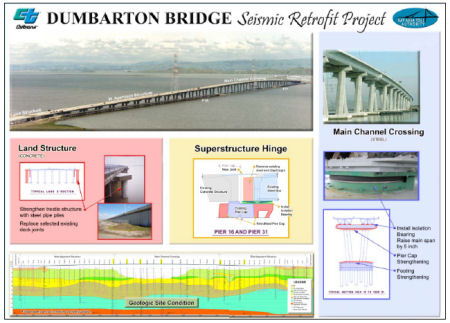 In July 2011, it was reported that Caltrans plans to retrofit the Dumbarton
Bridge. The current Dumbarton Bridge was opened to traffic in 1982 linking
the cities of Newark in Alameda County and East Palo Alto in San Mateo
County. The 1.6 mile long bridge has six lanes (three in each direction)
and an eightfoot bicycle/pedestrian pathway. The bridge is a combination
of reinforced concrete and steel girders that support a reinforced
lightweight concrete roadway on reinforced concrete columns. The current
retrofit strategy for the bridge includes superstructure and deck
modifications and installation of isolation bearings.
In July 2011, it was reported that Caltrans plans to retrofit the Dumbarton
Bridge. The current Dumbarton Bridge was opened to traffic in 1982 linking
the cities of Newark in Alameda County and East Palo Alto in San Mateo
County. The 1.6 mile long bridge has six lanes (three in each direction)
and an eightfoot bicycle/pedestrian pathway. The bridge is a combination
of reinforced concrete and steel girders that support a reinforced
lightweight concrete roadway on reinforced concrete columns. The current
retrofit strategy for the bridge includes superstructure and deck
modifications and installation of isolation bearings.
In December 2016, it was reported that a bill signed
into law this year by Gov. Jerry Brown has set into motion a study by
SamTrans in San Mateo County to convert the six-lane span from Fremont to
the Peninsula to use reversable lanes -- that is, four westbound lanes and
two eastbound lanes in the morning, then flip-flopping that configuration
in the afternoon. A movable median barrier like that on the Golden Gate
Bridge would be used. It won’t happen quickly, and may be a decade
away. But the first reports will be ready in May 2017. Questions persist
over costs, impacts on key roads off the bridges such as University Avenue
in East Palo Alto and whether the extra lane should be reserved for
carpoolers or converted into express lanes. Caltrans has considered
reversible lanes on the San Mateo Bridge (Route 92), I-680 along the Sunol
Grade, and I-80 in the East Bay but found problems that stopped those
efforts. The Dumbarton has several key factors in its favor. Around 80
percent of traffic is jammed together in the peak driving direction, while
just 20 percent is going the opposite way. Caltrans will consider
reversible lanes only if there is a 65-35 split and if it can ease delays
for three decades or more. The Dumbarton is almost a straight shot with
few curves that could make using a reversible barrier tricky.
(Source: Monterey Herald, 12/18/2016)
 Named Structures
 Bridge 35-038 (084 SM R029.25) over San Francisco Bay between San Mateo and Alameda counties is named the "Dumbarton
Bridge". It was never officially named. The name comes from
Dumbarton Point, which itself apparently dates to 1876 when it was named
after the town of Dumbarton in Scotland. About the same time, Origin Mowry
established a successful landing on the deep slough just south of
Dumbarton Point. Railroads also played a part in the growth of the area
when the narrow-gauge Santa Clara Valley Railroad was bought by James
Fair, James Flood and Alfred "Hog" Davis. They renamed the line the South
Pacific Coast Railroad, extended the railroad from Dumbarton Point to
Santa Cruz, and eventually offered daily commute service north to the
Alameda Pier. In addition, people could catch the railroad's ferry
"Newark," which ran daily trips from Dumbarton Point to San Francisco.
Eventually that railroad was bought by Southern Pacific and this area
became one of the busiest freight junctions in California. In 1907, the
railroad built a bridge just north of the current Dumbarton Bridge. In
1927, the original Dumbarton Bridge, the first vehicular crossing of San
Francisco Bay, was opened to traffic. It linked southern Alameda County on
the east to San Mateo County on the west. Built originally to provide a
shortcut for traffic originating in San Mateo and Santa Clara Counties,
the bridge served industrial and residential areas on both sides. The
bridge was built with private capital and then purchased by the State for
$2.5 million in 1951. Portions of this old drawbridge remain as fishing
piers. Its age and the limitations of a two-lane undivided roadway and
lift-span made it necessary for a replacement bridge to be constructed 90
feet to the north. This bridge was opened to traffic in October 1982 as a
four-lane, high-level structure. The cost of the complete project was $200
million. Following the Loma Prieta earthquake in 1989, Caltrans converted
the shoulders to additional travel lanes. It is 8,600 feet long with a
shoulder in each direction for supposedly for emergency use (but in
reality, too narrow for emergency use) and a two-way bicycle and
pedestrian path on the eastbound side. A 340-foot center span provides 85
feet of vertical clearance for shipping. The approach spans on both sides
of the Bay are of prestressed lightweight concrete girders supporting a
lightweight concrete deck. The center spans are twin steel trapezoidal
girders which also support a lightweight concrete deck.
Bridge 35-038 (084 SM R029.25) over San Francisco Bay between San Mateo and Alameda counties is named the "Dumbarton
Bridge". It was never officially named. The name comes from
Dumbarton Point, which itself apparently dates to 1876 when it was named
after the town of Dumbarton in Scotland. About the same time, Origin Mowry
established a successful landing on the deep slough just south of
Dumbarton Point. Railroads also played a part in the growth of the area
when the narrow-gauge Santa Clara Valley Railroad was bought by James
Fair, James Flood and Alfred "Hog" Davis. They renamed the line the South
Pacific Coast Railroad, extended the railroad from Dumbarton Point to
Santa Cruz, and eventually offered daily commute service north to the
Alameda Pier. In addition, people could catch the railroad's ferry
"Newark," which ran daily trips from Dumbarton Point to San Francisco.
Eventually that railroad was bought by Southern Pacific and this area
became one of the busiest freight junctions in California. In 1907, the
railroad built a bridge just north of the current Dumbarton Bridge. In
1927, the original Dumbarton Bridge, the first vehicular crossing of San
Francisco Bay, was opened to traffic. It linked southern Alameda County on
the east to San Mateo County on the west. Built originally to provide a
shortcut for traffic originating in San Mateo and Santa Clara Counties,
the bridge served industrial and residential areas on both sides. The
bridge was built with private capital and then purchased by the State for
$2.5 million in 1951. Portions of this old drawbridge remain as fishing
piers. Its age and the limitations of a two-lane undivided roadway and
lift-span made it necessary for a replacement bridge to be constructed 90
feet to the north. This bridge was opened to traffic in October 1982 as a
four-lane, high-level structure. The cost of the complete project was $200
million. Following the Loma Prieta earthquake in 1989, Caltrans converted
the shoulders to additional travel lanes. It is 8,600 feet long with a
shoulder in each direction for supposedly for emergency use (but in
reality, too narrow for emergency use) and a two-way bicycle and
pedestrian path on the eastbound side. A 340-foot center span provides 85
feet of vertical clearance for shipping. The approach spans on both sides
of the Bay are of prestressed lightweight concrete girders supporting a
lightweight concrete deck. The center spans are twin steel trapezoidal
girders which also support a lightweight concrete deck.
(Source: Statistics on the Dumbarton Bridge from
the Caltrans Dumbarton Bridge site; Image source: Twitter)
 Commuter Lanes
Commuter lanes exist in Alameda County on the approach to the Dumbarton Bridge, from Newark Blvd to west of the Toll Plaza, for 1.8 mi. These were opened in October 1982, were extended in 1989 to University Avenue due to the Loma Prieta earthquake, were shorted back to the toll plaza in 1990, and had the occupancy requirement reduced in 1992. They require two or more people, and are in operation weekdays between 5:00am and 10:00am and between 3:00pm and 6:00pm.
According to the Mercury News in June 2007, by 2017, there are plans to add HOVs across the Dumbarton Bridge from Newark Avenue to the toll plaza. This is odd, as these lanes already exist.
 Freeway
(c) (1) The commission may relinquish to the City of Fremont the portion of Route 84 within its city limits between Route 880, approximately post mile 6.922, and Route 238 Mission Boulevard, approximately post mile 10.83, upon terms and conditions the commission finds to be in the best interests of the state, if the department and the city enter into an agreement providing for that relinquishment.
(2) A relinquishment under this section shall become effective on the date following the county recorder’s recordation of the relinquishment resolution containing the commission’s approval of the terms and conditions of the relinquishment.
(3) On and after the effective date of the relinquishment, all of the following shall occur:
(A) The relinquished portion of Route 84 shall cease to be a state highway.
(B) The relinquished portion of Route 84 shall be ineligible for future adoption under Section 81.
(C) For the relinquished portion of Route 84, the City of Fremont shall maintain signs within its jurisdiction directing motorists to the continuation of Route 84.
In October 2019, the CTC authorized relinquishment of right of way in the
city of Fremont (City) on Route 84 (Thornton Avenue, Fremont Boulevard,
Peralta Boulevard, and Mowry Avenue) (04-Ala-84-PM 7.1/10.8), under terms
and conditions as stated in the relinquishment agreement dated August 19,
2019, determined to be in the best interest of the State. Authorized by
Chapter 461, Statutes of 2018, which amended Section 384 of the Streets
and Highways Code.
(Source: October 2019 CTC Agenda, Agenda Item 2.3c)
Post 1964 Signage HistoryIn 1963, this segment was covered by the original segment (b): "(b) Route 35 to Route 238."
In 1984, Chapter 409 rewrote segments (a) and (b) and relocated the discontinuity to US 101, making this segment the new (b): "(a) Route 1 near San Gregorio to Route 101 at Woodside Road in Redwood City. (b) Route 101 at Marsh Road in Menlo Park to Route 238."
In 1988, Chapter 106 split segment (b) and made the definition more specific: "(b) Route 101 at Marsh Road in Menlo Park to Route 880. (c) Route 880 to Route 238."
In 2018, SB 989, Chapter 461, 9/17/2018, added section (c) authorizing the relinquishment to the City of Fremont the portion of Route 84 within its city limits between Route 880, approximately post mile 6.922, and Route 238 Mission Boulevard, approximately post mile 10.83, upon terms and conditions the commission finds to be in the best interests of the state, if the department and the city enter into an agreement providing for that relinquishment. It also may have renumbered the statute with (a) being the list of segments; (b) being the relinquishment in West Sacramento; and (c) being the relinquishment in Fremont.
In October 2019, the CTC authorized
relinquishment of right of way in the city of Fremont (City) on Route 84
(Thornton Avenue, Fremont Boulevard, Peralta Boulevard, and Mowry Avenue)
(04-Ala-84-PM 7.1/10.8), under terms and conditions as stated in the
relinquishment agreement dated August 19, 2019, determined to be in the
best interest of the State. Authorized by Chapter 461, Statutes of 2018,
which amended Section 384 of the Streets and Highways Code. Specifically,
the relinquishment starts at the San Pedro Drive interchange, and
continues to Mission Blvd.
(Source: October 2019 CTC Agenda, Agenda Item 2.3c)
Pre 1964 Signage HistoryRoute 84 was signed as part of the original set of state signed routes in 1934. This segment was part of the 1933 portion of LRN 107. This was signed as Route 84 in 1961, when the CHC approved sign route 84 as "State Sign Route 84 in San Mateo and Alameda counties, extending from the junction with State Sign Route 1 at San Gregorio to the junction with US 50 (I-5W) near Livermore. The route passes through La Honda, Woodside, Menlo Park, Fremont, Newark, Sunol, and Livermore, and extends across the Dumbarton Bridge."
StatusThis segment is not constructed to freeway standards.
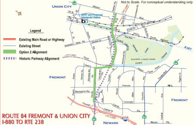
Fremont and Union City (~ ALA 6.981 to ALA 10.785)
There is a new project that provides for construction of a new parkway from I-880 to a point on Mission Boulevard near the Fremont/Union City border. From there Route 84 will be rerouted along a section of Mission Boulevard to Niles Canyon Road where it joins the current route through the Canyon.
![[Acta Rte 84 Project]](maps/acta84project.jpg) In early 2003, the city councils of Fremont and Union City agreed on a compromise for realigning
Route 84. The agreement would have included construction of a portion of
the Route 84 parkway between Mission Blvd (Route 238) and Alvarado-Niles
Blvd. Route 84 would then continue north on Alvarado-Niles to Decoto Road,
and then west on Decoto to the Dumbarton Bridge. Decoto Road would have
been widened from Paseo Padre Pkwy to I-880, and the Decoto/Alvarado-Niles
intersection would have been improved. The current Route 84 on Mowry,
Peralta, Fremont, Thornton, and I-880 would have been decertified and
control of the city streets will return to the city of Fremont. However,
Union City favored a parkway alignment running from I-880 at Decoto Rd in
Fremont to Mission Blvd at 7th St in Union City, while the
Fremont city council was opposed to any route running through the city of
Fremont. The mayors of the two cities were unable to agree on a
compromise, and the project appeared to be dead. However, in June 2005,
there was a new proposal. This proposal would involve construction of a portion of the Route 84 Parkway between Mission Blvd and Paseo Padre Blvd. Route 84 would then continue north on Paseo Padre to Decoto Road, and then west
on Decoto to the Dumbarton Bridge.
In early 2003, the city councils of Fremont and Union City agreed on a compromise for realigning
Route 84. The agreement would have included construction of a portion of
the Route 84 parkway between Mission Blvd (Route 238) and Alvarado-Niles
Blvd. Route 84 would then continue north on Alvarado-Niles to Decoto Road,
and then west on Decoto to the Dumbarton Bridge. Decoto Road would have
been widened from Paseo Padre Pkwy to I-880, and the Decoto/Alvarado-Niles
intersection would have been improved. The current Route 84 on Mowry,
Peralta, Fremont, Thornton, and I-880 would have been decertified and
control of the city streets will return to the city of Fremont. However,
Union City favored a parkway alignment running from I-880 at Decoto Rd in
Fremont to Mission Blvd at 7th St in Union City, while the
Fremont city council was opposed to any route running through the city of
Fremont. The mayors of the two cities were unable to agree on a
compromise, and the project appeared to be dead. However, in June 2005,
there was a new proposal. This proposal would involve construction of a portion of the Route 84 Parkway between Mission Blvd and Paseo Padre Blvd. Route 84 would then continue north on Paseo Padre to Decoto Road, and then west
on Decoto to the Dumbarton Bridge.
 Both Paseo Padre and Decoto would be widened. However, according to this note, that proposal was also unsuccessful, as Caltrans did not support it. Now, the Alameda County Transportation Authority has to decide
what to do with almost $100 million that for the past 20 years had been
slated for realigning Route 84. Union City would get the bulk of the
money, $55 million, to build its part of the road from Mission Boulevard
to Alvarado-Niles Road. The money also would be used to mitigate traffic
problems expected to arise from not building the new connection all the
way to I-880. Fremont still will get the money it needs to complete the
Warm Springs interchange. Most of the money is expected to come from
Caltrans, which will sell the state-owned land that had been intended for
Route 84. In June 2006, the parties involved reached a concensus. The
selection that received consensus -- known as "Option 2" -- includes only
construction of the four lane parkway with a landscaped median between
Mission Blvd and Paseo Padre Pkwy. There will be no parkway between Paseo
Padre and I-880. Instead, portions of Paseo Padre and Decoto Road will be
widened and improved.
Both Paseo Padre and Decoto would be widened. However, according to this note, that proposal was also unsuccessful, as Caltrans did not support it. Now, the Alameda County Transportation Authority has to decide
what to do with almost $100 million that for the past 20 years had been
slated for realigning Route 84. Union City would get the bulk of the
money, $55 million, to build its part of the road from Mission Boulevard
to Alvarado-Niles Road. The money also would be used to mitigate traffic
problems expected to arise from not building the new connection all the
way to I-880. Fremont still will get the money it needs to complete the
Warm Springs interchange. Most of the money is expected to come from
Caltrans, which will sell the state-owned land that had been intended for
Route 84. In June 2006, the parties involved reached a concensus. The
selection that received consensus -- known as "Option 2" -- includes only
construction of the four lane parkway with a landscaped median between
Mission Blvd and Paseo Padre Pkwy. There will be no parkway between Paseo
Padre and I-880. Instead, portions of Paseo Padre and Decoto Road will be
widened and improved.
(Thanks to Andy Gross for providing this
information)
In February 2018, it was reported that the plan for
Fremont to regain local control of Route 84 is moving forward. A state
legislator has introduced a bill that would relinquish ownership of a
portion of Route 84 to the city of Fremont. The section of highway in
question consists of nearly 3 miles of Decoto Road between I-880 and
Mission Boulevard, roughly half of which runs through Union City north of
Alameda Creek. "Fremont has long desired to have Caltrans relinquished
(sic) this portion of the route when the time was right," Senate Bill 989
author State Sen. Bob Wieckowski, D-Fremont, said in a statement. "Now
everything is coming into place." The move has been in progress since the
city entered into a memorandum of understanding with the Alameda County
Transportation Commission, Caltrans and Union City in 2006, but was
significantly delayed by the economic recession of 2008. City officials
have a number of improvements planned like safer routes for walking to
school, more curb ramps that comply with the Americans with Disabilities
Act, updated traffic signals, rebuilt pavement surfaces and various
enhancements to the Centerville business district - a project which could
begin as soon as 2020 and be completed by 2021.
(Source: Union City Patch, 2/7/2018)
On AARoads, Sparker provided some additional
information on Fremont's plans. The portion of Route 84 in Fremont that's
being considered for relinquishment does not use Decoto Road (that's part
of a long-postponed realignment plan); it extends east from I-880 on
Thornton Ave. to Fremont Blvd., south on Fremont to Peralta Ave., east on
Peralta to East Mowry Ave., and east on Mowry to Route 238/Mission Blvd.
Fremont is trying to redevelop their "old town", which contains the Route 84 alignment, so they're asking for the relinquishment for somewhat more
latitude regarding street configuration. No word if they're planning to
maintain Route 84 continuation signage.
(Source: Scott Parker (Sparker) on AARoad, 3/1/2018)
The 2018 STIP, approved at the CTC March 2018 meeting, includes a modification for PPNO 0081J, East-West Connector in Fremont. This project (ALA 84 PM 6.9/10.8), in the cities of Fremont and Union City, from Route 880 to Route 238 (Mission Boulevard), would construct a 4-6 lane expressway on existing and new alignment. The modification appears to delete $12,000K in construction funding in FY20-21; this funding appears to have been replaced by MTC funding in the same amount in FY18-19, which combines with $156,257K funding from the ACTC. Prior FY funding totalled $56,659K.
In September 2018, Gov. Jerry Brown signed a bill that
gives the city of Fremont the stretch of Route 84 between I-880 and
Mission Boulevard (to be precise, it probably authorizes relinquishment
upon acceptance by the city/county, and includes improvements to the
highways by Caltrans before relinquishment). Sen. Bob Wieckowski,
D-Fremont, a member of the Senate Transportation and Housing Committee,
authored the bill. It is part of a 2006 agreement with Fremont, the
Alameda County Transportation Commission, Caltrans and Union City. The
city has a variety of plans to make improvements to the route, including
repaving work, installing curb ramps and more efficient traffic signals,
and creating safer walking routes to school.
(Source: Fremont Patch, 9/18/2018)
In October 2019, the CTC authorized relinquishment of
right of way in the city of Fremont (City) on Route 84 (Thornton Avenue,
Fremont Boulevard, Peralta Boulevard, and Mowry Avenue) (04-Ala-84-PM
7.1/10.8), under terms and conditions as stated in the relinquishment
agreement dated August 19, 2019, determined to be in the best interest of
the State. Authorized by Chapter 461, Statutes of 2018, which amended
Section 384 of the Streets and Highways Code.
(Source: October 2019 CTC Agenda, Agenda Item 2.3c)
Freeway[SHC 253.5] Entire portion. Added to the Freeway and Expressway system in 1959.
 From Route 238 to Route 680 near Scotts Corners via the vicinity of Sunol.
Post 1964 Signage HistoryThis segment remains as defined in 1963.
Pre 1964 Signage HistoryThis was also part of the 1933 LRN 107. It was not part of the original state signage in 1934, but was signed by 1963.
StatusNiles Canyon Road (~ ALA 10.88 to ALA 17.901)
Caltrans has also been working on safety improvements along Niles Canyon Road. The agency has proposed widening and adding both medians and shoulders to the meandering two-lane state highway as well as building nearly two miles of cement retaining walls. The work is designed to reduce fatal accidents along the scenic route from Fremont to Sunol and I-680. Caltrans proposed the project after traffic injury statistics showed that the road had a higher than average percentage of fatal and injury collisions. From 1999 to 2008, there were 426 accidents on the road, resulting in 11 fatalities and 226 injuries, according to Caltrans. However, residents, environmental groups and city officials fear it would increase speeds and diminish the beauty of Niles Canyon, and are strongly opposed. They argue that Caltrans instead should consider measures to slow traffic or ban trucks on the road, which were involved in 38% of the injury accidents. Caltrans also is dealing with concerns from the California Regional Water Quality Control Board, which warned in a letter last month that it might not issue permits for the work if it posed significant threats to habitat along nearby Alameda Creek. The Niles Canyon Railway has also warned Caltrans that the work, which involves cutting into a railway embankment, could force it to shut down its weekend passenger service from Sunol to Fremont during construction.
Caltrans has divided the work along Niles Canyon Road
into three projects. The first, which faced little opposition, involves
widening shoulders and improving sight distances along portions of the
road in Fremont, Union City and the county, and could be completed by
2013. The third project, a new Alameda Creek Bridge, hasn't undergone
environmental review yet. But the second project, which is still under
environmental review and calls for removing 439 native trees to make way
for retaining walls, has run into strong opposition. The second project
would include a 2-foot center median and standard 8-foot shoulders on
sections of the road mostly around Sunol. It also would soften curves to
allow drivers to see farther down the road. The environmental review
period for it has been extended to Oct. 7, 2010, and Caltrans will decide
in Spring 2011 whether to move forward with the road improvements.
(Source: Oakland Tribune, 9/14/10; Mercury News, 9/23/10)
In March 2010, it was reported that a battle was
brewing over the Niles Canyon Widening. Citing safety concerns, Caltrans
plans to widen the scenic, winding road by 20 feet in some areas, adding
shoulders and a median. The road between Niles, once a bustling
moviemaking hub, and Sunol (where the route meets I-680) would remain two
lanes. The first phase of the project is already under way. Caltrans has
removed about 80 sycamores, oaks, alders and other trees alongside the
stretch of the road near the Union City border. But the next two phases
have yet to be approved, and residents and environmentalists hope to
derail them. Removing the trees has a broad impact on the environment. The
trees provide food, shelter and shade for wildlife, as well as control
erosion along the creek bed. Caltrans' plans call for retaining walls,
replacing Alameda Creek Bridge and adding 8- to 10-foot shoulders on both
sides of the road. For every tree that's removed, Caltrans said it will
plant three to five to replace them, mostly in the Alameda Creek
watershed. Caltrans embarked on the project almost a decade ago, hoping to
curb the high number of accidents along the road. From 1998 10 2008, Niles
Canyon Road saw 436 collisions, resulting in 13 deaths and 342 people
injured.
(Source: SF Chronicle, 3/10/11)
In December 2011, it was reported that Caltrans has
agreed to stop planning to widen the scenic, 8-mile route (Niles Canyon
Road) between Fremont and Sunol due to environmental concerns, according
to a legal settlement reached with the Alameda Creek Alliance. The
Alliance sued Caltrans in June to stop the $80 million project, which
called for widening the shoulders and adding retaining walls and a median
to Route 84. Caltrans has already removed about 100 sycamores, willows and
other trees in the canyon in preparation for the widening project; the
agency will have to plant replacements. Caltrans had also started repaving
the road before Alameda County Superior Court Judge Frank Roesch issued a
restraining order in June 2011; Caltrans must now rip up the new pavement
and replace the rumble strips it had removed. Note that the settlement
only stops the first phase of the project, the portion of the road closest
to Fremont. The next two phases are still under review. Caltrans is
expected to start over with the first phase, putting forth an
environmental impact report and essentially starting the process from
scratch.
(Source: SF Chronicle, 12/14/11)
In July 2012, it was reported that Caltrans had
scrapped their previous approach, and was restarting the Niles Canyon Road
project fresh because they want to make the scenic highway as safe as
possible. They held a public meeeting where they announced the clean slate
approach and heard community inputs for the process. The notion stressed
by the audience appeared to be wanting to make the road safer without
increasing traffic. The safety concerns were in six areas: (1) Roadside
Quality; (2) Limited Use Shoulders; (3) Speed Management; (4) Signs and
Markings; (5) Bicycles and Pedestrians; and (6) Intersections and Curves.
The details of these problems are on the Caltrans Niles Canyon website. The website presentations also identify proposed short-term, mid-term, and long-term mitigations.
(Source: Mercury News, 8/1/2012)
In December 2012, Caltrans introduced new proposals for
Niles Canyon Road. These included 16 short-term fixes for Route 84,
including placing reflective materials and signs on several underpasses
and guardrails, as well as increased signage and visibility. Twelve
medium-term solutions included road realignments; relocating railroad
abutments; widening roads; building roundabouts; and constructing
intersection signals, among other ideas. Caltrans also suggested only
implementing safety measures at certain points along the route, including
the Rosewarnes Underpass, the low speed areas between bridges, the
Palomares/Farwell Underpass, both intersections at Main Street and the
Pleasanton/Sunol exit, and the Alameda Creek Bridge. Improvements will
most likely involve installing reflective lights at Rosewarnes Underpass,
the low speed areas between bridges, the Palomares/Farwell Underpass, both
intersections at Main Street and the Pleasanton/Sunol exit, and the
Alameda Creek Bridge. Minor widening in these five areas will also be done
to allow for speed limit enforcement by California Highway Patrol. In
addition, Caltrans will remove vegetation obstructing safety signs, and
install new feedback signs, such as electronic ones that report drivers'
speeds. These improvements will not be done until at least 2014, as
Caltrans wants public feedback and review. There was still concern that
Caltrans planned on removing trees.
(Source: Mercury News, 12/28/2012)
Alameda Creek Bridge (04-Ala-84, PM 13.01/13.60)
") In May 2014, the CTC received notice of the preparation of an EIR for the
Alameda Creek Bridge replacement. The project in Alameda County will
replace the Alameda Creek Bridge on Route 84 in the city of Fremont. The
project is programmed in the 2014 State Highway Operation and Protection
Program. The total estimated cost is $47,074,000 for capital and support.
Construction is estimated to begin in Fiscal Year 2014-15. Alternatives
for the project include:
In May 2014, the CTC received notice of the preparation of an EIR for the
Alameda Creek Bridge replacement. The project in Alameda County will
replace the Alameda Creek Bridge on Route 84 in the city of Fremont. The
project is programmed in the 2014 State Highway Operation and Protection
Program. The total estimated cost is $47,074,000 for capital and support.
Construction is estimated to begin in Fiscal Year 2014-15. Alternatives
for the project include:
In April 2015, it was reported that the community was
still protesting Caltrans proposal for the Alameda Creek Bridge
replacement. Caltrans says the $24 million project will increase the
bridge's total width to 42 feet, giving bicyclists and motorists more room
to maneuver. Caltrans would widen the roadway's two lanes and add modern
safety railings and 8-foot shoulders on each side. The Alameda Creek
Alliance doesn't believe it is that simple, as the project will involve
removing hundreds of native trees and excavating along thousands of feet
of the canyon, adding large retaining walls. Caltrans aims to offset
adverse environmental changes caused by construction by incorporating many
mitigation elements, including providing bat roosts, removing creek
obstructions to improve fish passage and replanting trees. Opponents say
they do not oppose fixing the highway's unsafe spots, but they are
disappointed that Caltrans' latest proposal, its first since the 2011
dispute, doesn't seem that different from previous ones. Caltrans hopes to
break ground by the fall of 2017.
(Source: Contra Costa Times, 4/6/2015)
In January 2018, the CTC approved for future
consideration of funding the following project for which a Final
Environmental Impact Report (FEIR) has been completed: Route 84
(04-Ala-84, PM 13.01/13.60) in Alameda County. Replace existing bridge on
Route 84 in the city of Fremont. (PPNO 0084B). This project is located
within the Niles Canyon Corridor, in the city of Fremont, Alameda County.
The project proposes to replace the Alameda Creek Bridge (Bridge №
33-36) and realign the bridge approaches on Route 84. The proposed project
will correct structural deficiencies of the bridge and its approaches as
well as improve road safety. The project is fully funded and programmed in
the 2016 State Highway Operation and Protection Program (SHOPP) an
estimated total $42 million which includes Construction (capital and
support) and Right-of-Way (capital and support). Construction is estimated
to begin in Fiscal Year 2019-20. The scope, as described for the preferred
alternative, is consistent with the project scope programmed by the
Commission in the 2016 SHOPP.
(Source: CTC Minutes, January 2018, Agenda Item 2.2c(2))
The following project was included in the final adopted 2018 SHOPP: PPNO 0084B. 04-Alameda-84 13.0/13.6 On Route 84, In Fremont, at Alameda Creek Bridge № 33-0036. Replace bridge. Begin Con: 12/8/2019 Total Project Cost: $42.074M.
In June 2020, the CTC amended the SHOPP regarding
04-Ala-84 13.0/13.6. PPNO 0084B ProjID 0400000429 EA 16030. Route 84 in
Fremont, at Alameda Creek Bridge № 33-36. Replace bridge. Adjust
funding to Split environmental mitigation and plant establishment work
from this project into EA 16031/PPNO 04-1084B.
(Source: June 2020 CTC Minutes, Agenda Item
2.1a.(1d) #2)
In June 2020, the CTC approved the following allocation
for CONST and CON ENG: $33,065,000. 04-Ala-84 13.0/13.6. PPNO 04-0084B.
ProjID 0400000429. EA 16030. Route 84 in Fremont, from 0.3 mile south to
0.3 mile north of Alameda Creek Bridge № 33-0036. Outcome/Output:
Replace aging bridge by constructing a new bridge on a new alignment to
upgrade bridge railing, improve load capacity, curve radius, and sharp
approaches to the bridge, and widen shoulders to standard. As part of this
allocation request, the Department is requesting to extend the completion
of CONST and CON ENG an additional 6 months beyond the 36 month deadline.
Fourteen month time extension for CONST and CON ENG approved under Waiver
19-29; June 2019.
(Source: June 2020 CTC Agenda, Agenda Item 2.5b.(1)
#8)
In February 2021, it was reported that the first phase
of a safety improvement project on Route 84 in Alameda County was nearing
completion. The removal of trees that began in November 2020 is expected
to wrap up in March 2021 to make room for road improvements. The next
phases of the project — scheduled to be completed in 2024 —
include building a new Alameda Creek Bridge and retaining wall, installing
a traffic signal at Route 84 and Main Street in Sunol to relieve traffic
congestion and make the intersection safer, installing a traffic signal at
Pleasanton Sunol Road and Niles Canyon Road and installing traffic signs
and active warning signs for cyclists.
(Source: Local News (Bay Area) Matters, 2/19/2021)
In October 2022, the CTC approved a request for an
additional $2,500,000 in Construction Support for the SHOPP Bridge
Rehabilitation project on Route 84, in Alameda County, to complete the
construction
contract. This project is located on Route 84, near the City of Fremont,
at the Alameda Creek Bridge № 33-0036, in Alameda County (04-Ala-84
13.0/13.6. PPNO 04-0084B. ProjID 0400000429. EA 16030). The project
will replace the existing bridge, that is located within Niles Canyon, by
constructing it on a new and improved alignment, in addition to improving
the roadway approaches, and widening shoulders to current standards. In
December 2020, construction began with 620 working days. The project
has not received G-12 funds. The remaining funds are currently at
$560,000 in Construction Support. The project is 25 percent complete
with 435 working days remaining. The planned Construction Contract
Acceptance is scheduled for December 2024. The project realized cost
increases due to delays that occurred during construction, as a result of
environmental permit requirements and contract change orders, resulting in
the need for additional construction support to address these
unanticipated construction issues.The project encountered an active bird
nest, which delayed installation of the creek diversion system, which in
turn delayed all work in the creek bed. In order to mitigate for the
delays, the contractor was authorized to accelerate critical work,
resulting in the need for additional construction support resources.
The contractor was allowed to work 10-hour shifts during the weekdays and
extended hours through the weekends. During construction of the soil nail
retaining wall, unstable soil was encountered at various locations,
requiring additional soil nails to be installed to stabilize the
area. Additional efforts were needed to place shoring in front of
the retaining wall to prevent further erosion and protect the permanent
landscape characteristics. These efforts resulted in the need for
additional inspection of the work.Unstable soil and erosion were also
found under the existing paved slope and shoulder of the eastern approach
of the bridge where piles are proposed. Additional support resources were
utilized to oversee and inspect the work to stabilize the soil. The
unstable soil required increased removal of the paved slope and shoulder,
to be able to properly reconstruct the embankment around the piles.
Stabilizing the exposed slope required the installation of a temporary
dirt bench. Permanent steel casings were also added to the affected
piles to prevent cave-ins during drilling. In addition, the piles
were lengthened in order to increase pile capacity to address the
non-cohesive soil.Also, during the drilling of the Cast-in-Drilled-Holes
(CIDH) holes, unidentified aquifers were encountered that cause
groundwater to rise which resulted in the need for additional support
resources to implement alternative construction methods. This
required the installation of sixteen 3-foot diameter, 70-foot-long secant
piles to form a ring around the main pile before CIDH pile drilling could
begin.In aggregate, the delays have resulted in the need of an additional
170 working days which increased the support cost beyond the original
programmed amount. The Department anticipates being able to complete the
remaining work of this project with the approval of the requested
supplemental funds.
(Source: October 2022 CTC Agenda, Agenda Item
2.5e.(6))
Arroyo De La Laguna Bridge № 33-0043 (ALA 17.0/17.4)
") The following project was included in the final adopted 2018 SHOPP: PPNO 0481M. 04-Alameda-84 17.0/17.4. On Route 84. Near
Sunol, at Arroyo De La Laguna Bridge № 33-0043. Replace/rehabilitate
bridge for scour mitigation, bridge rail upgrade, and seismic retrofit.
Begin Con: 12/7/2022. Total Project Cost: $22.813M.
The following project was included in the final adopted 2018 SHOPP: PPNO 0481M. 04-Alameda-84 17.0/17.4. On Route 84. Near
Sunol, at Arroyo De La Laguna Bridge № 33-0043. Replace/rehabilitate
bridge for scour mitigation, bridge rail upgrade, and seismic retrofit.
Begin Con: 12/7/2022. Total Project Cost: $22.813M.
The 2020 SHOPP, approved in May 2020, included the
following Bridge Preservation item of interest (carried over from the 2018
SHOPP): 04-ALA-84 PM 17.0/17.4 PPNO 0481M Proj ID 0414000012 EA 0J550
Route 84 near Sunol, at Arroyo De La Laguna Bridge № 33-0043.
Replace/rehabilitate bridge for scour mitigation, bridge rail upgrade and
seismic retrofit. Programmed in FY21-22, with construction starting
11/30/2022. Total project cost is $22,813K, with $13,500K being capital
(const and right of way) and $9,313K being support (engineering,
environmental, etc.),
(Source: 2020 Approved SHOPP a/o May 2020)
In June 2020, the CTC amended this project in the 2020
SHOPP as follows: 04-Ala-84 17.0/17.4 16.9/17.5.
PPNO 0481M ProjID 0414000012 EA 0J550. Route 84 near Sunol, at Arroyo De
La Laguna Bridge № 33-0043. Replace/rehabilitate bridge for
scour mitigation, bridge rail upgrade, and seismic retrofit.
Replace bridge, realign roadway and construct roundabouts.
Allocation changes: Con Sup $3,600K $4,000K R/W
Cap $500K $1,500K; Const Cap $13,000K
$16,000K; Total $22,813K $27,213K.
During the environmental phase, it was determined that realigning the
bridge adjacent to the existing structure will reduce construction
duration, correct sharp turns, improve sight distance, avoid impacts to a
nearby school, allow for construction of roundabouts for better traffic
operations, and provide strong support from the community. Update
postmiles, scope, delivery year, and cost to reflect these changes.
(Source: June 2020 CTC Agenda, Agenda Item
2.1a.(5d) #5)
In January 2022, the CTC approved for future
consideration of funding Arroyo de la Laguna Bridge Project
(04-Ala-84, PM 17.2): Repair bridge scour and correct structural
deficiencies of the Arroyo de la Laguna Bridge on Route 84 in Alameda
County. (PPNO 0481M) The project is located on Route 84 at postmile 17.2
in the town of Sunol, in Alameda County. Caltrans proposes to
replace the Arroyo de la Laguna Bridge (Bridge № 33-0043) to address
scour and seismic concerns and meet current design standards for safety.
The project is currently programmed in the State Highway Operation and
Protection Program (SHOPP) for a total of $27,213,000, which includes
Construction (capital and support) and Right of Way (capital and
support). Construction is estimated to begin in 2023-24. The scope,
as described for the preferred alternative, is consistent with the project
scope as programmed by the Commission in the 2020 SHOPP.
(Source: January 2022 CTC Agenda, Agenda Item
2.2c.(3))
In January 2022, the CTC approved the following SB1
SHOPP support phase allocation: $4,475,000. 04-Ala-84 16.9/17.5. PPNO
04-0481M; ProjID 0414000012; EA 0J550. Route 84 Near Sunol, at Arroyo De
La Laguna Bridge № 33-0043. Replace bridge, realign roadway and
construct roundabouts. (Concurrent consideration of funding under
Resolution E-22-03; January 2022.) Allocation: PS&E $4,200,000
($3,600,000 programmed); R/W Sup $275,000 ($250,000 programmed).
(Source: January 2022 CTC Agenda, Agenda Item
2.5b.(2b) #6)
In June 2023, the CTC amended the following project in
the 2022 SHOPP: 04-Ala-84 16.9/17.5. PPNO 04-0481M; ProjID 0414000012; EA
0J550. Route 84 Near Sunol, at Arroyo De La Laguna Bridge № 33-0043.
Replace bridge, and realign roadway and construct
roundabouts. Note: Update design method for bridge
replacement and remove roundabout. Decrease R/W capital because of the
reduced scope and fewer needed R/W acquisitions. Increase construction
capital because of bridge widening to accommodate staging and avoid nearby
school, and increased water diversion cost. Increase construction support
because of increased construction duration and complex staging. Allocation
($ × 1,000): PA&ED $1,863; PS&E $3,600; R/W Sup $250; Con Sup
$4,000 $6,750; R/W Cap $1,500 $500;
Const Cap $16,000 $33,000; TOTAL $27,213
$45,963. FY23-24.
(Source: June 2023 CTC Agenda, Agenda Item 2.1a.(1d) #21)
 Scenic Route
[SHC 263.5] Entire portion.
 From Route 680 near Scotts Corners to I-580 in Livermore.
Post 1964 Signage HistoryIn 1963, this segment was defined as "(d) Route 680 near Scotts Corners to I-580."
In 1988, Chapter106 changed this to "I-580 in Livermore."
Pre 1964 Signage HistoryThis was LRN 108, and was defined in 1933. It was not part of the original state signage in 1934, but was signed by 1963. On November 22, 1960, the California Highway Commission adopted an alignment for Route 84 that generally extends along Isabel Avenue from Vallecitos Road connecting to I-580 in the vicinity of Collier Canyon Road. This is illustrated in the May-June 1962 of CHPW.
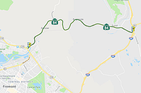
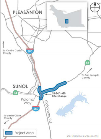
StatusRoute 84/I-680 Interchange Improvements: 4–ALA–84 (PM 17.9/22.9)
The 2018 STIP, approved at the CTC March 2018 meeting, appears to modify this. It includes $11,114K funding in FY19-20 for PPNO 0080D, Widen, s/o Ruby Hill-Rt 680, Rt 84/680 IC Imprvs(TCEP). This is the "SR-84 Widening and SR-84/I-680 Interchange Improvements Project". This project proposes to proposes to conform Route 84 to expressway standards between south of Ruby Hill Drive and the I-680 interchange in southern Alameda County (4–ALA–84 (PM 17.9/22.9), 4–ALA–680 (PM 10.3/15.3)) by: (•) Widening Route 84 to accommodate one additional lane in each direction; (•) Implementing additional improvements to reduce weaving/merging conflicts and help address the additional traffic demand between I-680 and Route 84. The project would also improve the SR-84/I-680 interchange operations by: (•) Modifying ramps; and (•) Extending the existing southbound I-680 High Occupancy Vehicle/Express Lane northward by ~2 miles. Currently, the southbound express lanes extend from Route 84 south of Pleasanton to Route 237 in Milpitas. The amount of funding in the 2018 STIP agrees with the amount that the Alameda County Transportion Commission (ACTC) requested in regional improvement funding; it combines with $122,000K in Measure BB funding, $1,046K in Measure B funding, $14,940K in local (Tri-Valley Transportation Council) funding. ACTC has requested an additional $70,900K in SB1 funding for this. Currently, construction is scheduled for Winter 2021 - Winter 2023.
Note that most of the information on this project is
with Route 84. With respect to southbound I-680, the project would extend
the existing HOV/express lane northward from its current entry point at
approximately Calaveras Road to approximately 0.8 mile north of Koopman
Road, a distance of approximately 2 miles. The pavement in the center
median of southbound I-680 would be widened to accommodate the HOV/express
lane. Approximately six overhead signs (including variable toll message
signs [VTMS] with pricing information) and toll readers for FasTrak
transponders would be installed in the median of I-680. The northernmost
overhead sign would be approximately 1.8 miles north of Koopman Road (at
4-Ala-680 PM 14.2). Proposed project activities between the northernmost
overhead sign and the I-680/Sunol Boulevard interchange would be limited
to the placement of temporary construction signage.
(Source: August 2017 Draft EIR)
In July 2023, it was reported that MTC’s
Programming and Allocations Committee recommended allocations of Regional
Measure 3 toll dollars for this project. The committee's recommendation
will be considered by the full Commission at its July 26 2023 meeting. The
specific allocation was: Alameda County Transportation Commission: $85
million for the I-680/Route 84 Interchange Reconstruction Project.
(Project underway, completion expected early 2025.)
(Source: MTG/ABAG Bay Link Blog, 7/12/2023)
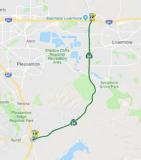
Route 84 Expressway / Sunol to Ruby Hill Widening (04-Ala-84, PM 17.9/23.0, 04-Ala-680, PM 10.3/15.3)
 In October 2016, the CTC approved for future consideration of funding the completed project in
Alameda County (04-Ala-84, PM 20.7/23.0) that added a median and turn
pockets, widened through-lanes and shoulders, and added climbing lanes on
a portion of Route 84. This realignment and widening project (PPNO 0086Z)
was programmed in the 2006 State Highway Operation and Protection Program
for $45,023,000 for capital and support. Construction was completed in
Fiscal Year 2012-13. Environmental mitigation for the project (PPNO 0085S)
is programmed in the 2016 State Highway Operation and Protection for
$1,750,000 for capital and support. The Future Consideration of Funding
was for this environmental mitigation project. The scope is consistent
with the project scope programmed by the Commission in the State 2016
Highway Operation and Protection Program.
In October 2016, the CTC approved for future consideration of funding the completed project in
Alameda County (04-Ala-84, PM 20.7/23.0) that added a median and turn
pockets, widened through-lanes and shoulders, and added climbing lanes on
a portion of Route 84. This realignment and widening project (PPNO 0086Z)
was programmed in the 2006 State Highway Operation and Protection Program
for $45,023,000 for capital and support. Construction was completed in
Fiscal Year 2012-13. Environmental mitigation for the project (PPNO 0085S)
is programmed in the 2016 State Highway Operation and Protection for
$1,750,000 for capital and support. The Future Consideration of Funding
was for this environmental mitigation project. The scope is consistent
with the project scope programmed by the Commission in the State 2016
Highway Operation and Protection Program.
(Image source: ACTC Project Page, ProjectOverview
Document, snarfed 6/16/2018)
The 2018 STIP, approved at the CTC March 2018 meeting, appears to modify this. It includes $11,114K funding in FY19-20 for PPNO 0080D, Widen, s/o Ruby Hill-Rt 680, Rt 84/680 IC Imprvs(TCEP). This is the "SR-84 Widening and SR-84/I-680 Interchange Improvements Project". This project proposes to proposes to conform Route 84 to expressway standards between south of Ruby Hill Drive and the I-680 interchange in southern Alameda County (4–ALA–84 (PM 17.9/22.9), 4–ALA–680 (PM 10.3/15.3)) by: (•) Widening Route 84 to accommodate one additional lane in each direction; (•) Implementing additional improvements to reduce weaving/merging conflicts and help address the additional traffic demand between I-680 and Route 84. The project would also improve the SR-84/I-680 interchange operations by: (•) Modifying ramps; and (•) Extending the existing southbound I-680 High Occupancy Vehicle/Express Lane northward by ~2 miles. Currently, the southbound express lanes extend from Route 84 south of Pleasanton to Route 237 in Milpitas. The amount of funding in the 2018 STIP agrees with the amount that the Alameda County Transportion Commission (ACTC) requested in regional improvement funding; it combines with $122,000K in Measure BB funding, $1,046K in Measure B funding, $14,940K in local (Tri-Valley Transportation Council) funding. ACTC has requested an additional $70,900K in SB1 funding for this. Currently, construction is scheduled for Winter 2021 - Winter 2023.
Per the draft EIR, The purpose of the project is to
alleviate existing and projected traffic congestion and improve traffic
circulation between Route 84 and I-680, and in the vicinity of the Route 84/I-680 interchange; improve safety for motorists and cyclists on this
segment of Route 84; and complete the statutory designation of this
segment of Route 84 as an expressway facility. An expressway is a type of
highway where access is typically limited to controlled locations such as
intersections. The project is needed because high transportation demand
leads to congestion and reduced vehicle speeds on Route 84 in the project
area. During the afternoon/evening peak commute period, congestion on
northbound Route 84 also contributes to a bottleneck at the weaving area
on northbound I-680 between the Calaveras Road/Route 84 on-ramp and
northbound Route 84 off-ramp. Motorists use local roadways and the
I-580/I-680 interchange to avoid the limited capacity and congestion along
Route 84, which further congests these routes.
(Source: August 2017 Draft EIR)
For Route 84, the proposed project would widen the route from two to four lanes (two in each direction) and overlay and restripe the roadway. The proposed roadway would have 12-foot-wide travel lanes and 10-foot-wide shoulders. A Class II bikeway would be provided in each direction. Concrete barriers would be placed in the median to enhance user safety. As part of conforming Route 84 to expressway standards, access would be limited to controlled intersections to improve traffic flow and safety. The project would consolidate existing vehicle access openings to private driveways and rural roads at new frontage roads. The proposed frontage roads would connect to a new signalized intersection at Little Valley Road/Vallecitos Atomic Laboratory Road. The new intersection and frontage roads would provide access to Little Valley Road on the north side of Route 84 and private driveways and rural roads on the south side of Route 84.
At the Route 84/I-680 interchange, the project would make the following modifications:
A new Class I bikeway would be provided through the interchange area to connect the southbound Route 84 Class II bikeway with Paloma Way. The bikeway will primarily serve westbound bicycle travel. A new Class II bikeway would be provided along the northbound I-680 on-ramp from Calaveras Road to connect with the northbound Route 84 Class II bikeway.
On southbound I-680, the project would extend the existing HOV/express lane northward from its current entry point at approximately Calaveras Road to approximately 0.8 mile north of Koopman Road, a distance of approximately 2 miles. The pavement in the center median of southbound I-680 would be widened to accommodate the HOV/express lane. Approximately six overhead signs (including variable toll message signs [VTMS] with pricing information) and toll readers for FasTrak transponders would be installed in the median of I-680. The northernmost overhead sign would be approximately 1.8 miles north of Koopman Road (at 4-Ala-680 PM 14.2). Proposed project activities between the northernmost overhead sign and the I-680/Sunol Boulevard interchange would be limited to the placement of temporary construction signage.
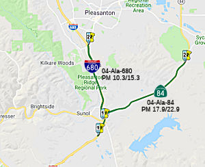 In August 2018, the CTC approved for future consideration
of funding the following project for which a Final Environmental Impact
Report (FEIR) has been completed: Route 84 and I-680 in Alameda County.
Construct roadway improvements including widening to a portion of Route 84
near the cities of Livermore and Pleasanton. (EA 29763) This project
proposes to widen and conform Route 84 to expressway standards between
Ruby Hill Drive and the I-680 interchange, in the vicinity of Sunol and
Pleasanton cities. The project proposes to improve interchange ramps and
extend the existing southbound I-680 High Occupancy Vehicle express lane.
A complete statutory designation as an expressway is expected for this
segment of Route 84. The proposed project is estimated to cost in total
approximately $220 million. The project is not fully funded, funding
sources are anticipated to be from local tax measures, Regional
Transportation Improvement Program funds and Alameda County. The project
is estimated to begin construction in 2021.
In August 2018, the CTC approved for future consideration
of funding the following project for which a Final Environmental Impact
Report (FEIR) has been completed: Route 84 and I-680 in Alameda County.
Construct roadway improvements including widening to a portion of Route 84
near the cities of Livermore and Pleasanton. (EA 29763) This project
proposes to widen and conform Route 84 to expressway standards between
Ruby Hill Drive and the I-680 interchange, in the vicinity of Sunol and
Pleasanton cities. The project proposes to improve interchange ramps and
extend the existing southbound I-680 High Occupancy Vehicle express lane.
A complete statutory designation as an expressway is expected for this
segment of Route 84. The proposed project is estimated to cost in total
approximately $220 million. The project is not fully funded, funding
sources are anticipated to be from local tax measures, Regional
Transportation Improvement Program funds and Alameda County. The project
is estimated to begin construction in 2021.
(Source: August 2018 CTC Agenda Item 2.2c.(10))
In January 2019, it was reported that the Alameda
County Transportation Commission (CTC) issued a report on projects that
they were able to leverage funding in order to improve transportation
throughout Alameda County. One of these projects is along Route 84, which
serves as a regional connection between I-680 and I-580 in Alameda County
through the community of Sunol and the cities of Pleasanton and Livermore.
Widening of Route 84 has been a priority of the City of Pleasanton because
it removes some of the cut through traffic on the city's streets. Since
2010, Alameda CTC's commitment of $213.5 million in local funds for this
corridor has successfully brought in additional local, state and federal
funds to construct four of the five projects. Construction on three of the
five projects is complete. The remaining project, the Route 84 Expressway
South Segment, which widens the segment from Ruby Hill Drive to Concannon
Boulevard from two lanes to four lanes, opened to the public two days
ahead of schedule on November 14, 2018. The passage of Measure BB in
November 2014 provided the necessary funds to begin the environmental
phase of the Route 84 Expressway Widening and Route 84/I-680 Interchange
Improvements. The project will transform the 3-mile segment from south of
Ruby Hill Drive to the I-680 interchange from two lanes to four lanes and
will provide operational improvements, such as ramp modifications at the
interchange. Both state and federal environmental clearances were achieved
this year. The project is currently in the design phase, and with the
infusion of $85 million from Regional Measure 3, the construction phase is
fully funded and is anticipated to begin in early 2021.
(Source: The Independent, 1/3/2019)
In March 2020, the CTC approved the 2020 STIP, which
made no changes to the funding programmed for PPNO 0080D Route 84 "Widen,
s/o Ruby Hill-Rt 680, Rt 84/680 IC Imprvs": $11, 114K in prior year CON
SUP.
(Source: March 2020 CTC Agenda, Item 4.7, 2020 STIP
Adopted 3/25/2020)
In June 2020, the CTC approved amending the Formulaic
Program of Projects in the Local Partnership Program (LPP) to program
$8,602,000 for Alameda County Transportation Commission to fund
construction support for the Route 84 Widening and Route 84/I-680
Interchange Improvements project in Fiscal Year 2019-20. In the cities of
Livermore and Pleasanton, the project will widen Route 84 (south of Ruby
Hill Dr. to I-680) from a two-lane highway to a four-lane expressway, make
operational improvements to the Route 84/I-680 interchange, and extend an
existing express lane by two miles. The project will improve safety,
reduce congestion, improve operations, bike and pedestrian access, and
connectivity.
(Source: June 2020 CTC Agenda, Agenda Item 4.21)
Isabel Avenue Corridor Realignment (~ ALA M23.587 to ALA N28.007)
Caltrans and the City of Livermore have proposed for some time the realignment of Route 84 onto the existing and extended Isabel Avenue (~ ALA M23.587 to ALA N28.007) from its current First Street routing. The Isabel extension was opened back in August 2001 as a two-lane road now connecting the existing Route 84 to Airway Boulevard near I-580. This roadway will eventually become a four- and six-lane parkway with a future interchange at I-580. In 2003, Caltrans redesignated Isabel as Route 84. [Thanks to Jeffrey Waller and Laurence Maller for this information.]
According to an observer in July 2004, the new bypass isn't complete; you have to first drive on Airway Blvd (which is the official designation for Route 84, until the rest of the bypass is constructed to connect with I-580 in the next several years). You drive on Airway Blvd for about ¾ mile, then make a right onto another street, and then a left onto the newly constructed bypass. The bypass has one lane in each direction in most parts, and is signed for 50 MPH. It looks like there's enough ROW for an 8 lane expressway, or 6 lane freeway in the future.
In December 2003, the California Transportation Commission approved a proposal to transfer the location of Route 84 from the alignment through downtown Livermore (Vallecitos, Holmes, and First) to the Isabel Avenue Corridor, with the old alignment being concurrently relinquished to the city. The existing alignment through the city of Livermore is built to conventional highway standards. The Isabel Avenue Corridor is generally built to expressway standards. The alignment along the Isabel Avenue Corridor will be adopted as a controlled access highway from Vallecitos Road to Airway Boulevard. The portion of the route that runs along Airway Boulevard will be adopted as a traversable highway. Airway Boulevard will be used as an interim connection to I-580 until the Isabel Avenue extension and new I-580 interchange is built. Once the new I-580 interchange is built a request will go to the Commission to adopt the new Isabel Avenue extension to I-580. Environmental clearance was received in late 2004 and construction completed in 2009.
The SAFETEA-LU act, enacted in August 2005 as the reauthorization of TEA-21, provided the following expenditures on or near this route:
In October 2011, the CTC recieved a request to amend the CMIA baseline agreements related to a project in this area; specifically, for Segment 1 (Widen and realign State Route 84 south of I-580 interchange and relocate utilities, PPNO 0115E), Segment 2 (Construct new local roads north of the I-580/Isabel Avenue Interchange, PPNO 0115F), and Segment 3 (Construct new interchange at Isabel Avenue and a new Portola Avenue Overcrossing, PPNO 0115B) of the I-580/Isabel Interchange project to: • Transfer a portion of the scope of work from Segment 3 to Segment 1. • Shift $600,000 CMIA and $400,000 local funds in close-out savings from Segment 2 to Segment 1 in order to complete this transferred scope of work.
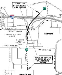 In August 2012, the CTC approved the transfer of the adopted alignment from Post Mile (PM) M27.2
to M28.2 along Airway Boulevard to a new shorter northerly alignment
connecting to I-580. A Project Report was approved on August 15, 2007. The
Department prepared a Mitigated Negative Declaration that was signed on
August 15, 2007. This transfer of alignment will allow existing Route 84
along Airway Boulevard to be relinquished to the City of Livermore and
utilize the new connection to the Isabella Avenue/I-580 Interchange. Route 84 is one of four east-west links between the urbanized Bay Area and the
Central Valley. On December 11, 2003, the California Transportation
Commission adopted Route 84 from Vallecitos Road north to Airway Boulevard
and then east on Airway Boulevard to I-580 as a Controlled Access Highway.
A Project Report and Environmental document were approved in 2007 for the
construction of a new interchange on I-580 at Isabel Avenue. This project
provides improved access to I-580 by converting the partial interchange at
Portola Avenue to an overcrossing and constructs a new interchange at
Isabel Avenue. This will improve the connection between the 2003 adopted
Route 84 corridor and I-580. In relation to this, in August 2012 the CTC
also authorized relinquishment of right of way in the city of Livermore on
Route 84 (Airway Boulevard), from Isabel Avenue to Route 580, consisting
of highway right of way superseded by a transfer of state highway
location.
In August 2012, the CTC approved the transfer of the adopted alignment from Post Mile (PM) M27.2
to M28.2 along Airway Boulevard to a new shorter northerly alignment
connecting to I-580. A Project Report was approved on August 15, 2007. The
Department prepared a Mitigated Negative Declaration that was signed on
August 15, 2007. This transfer of alignment will allow existing Route 84
along Airway Boulevard to be relinquished to the City of Livermore and
utilize the new connection to the Isabella Avenue/I-580 Interchange. Route 84 is one of four east-west links between the urbanized Bay Area and the
Central Valley. On December 11, 2003, the California Transportation
Commission adopted Route 84 from Vallecitos Road north to Airway Boulevard
and then east on Airway Boulevard to I-580 as a Controlled Access Highway.
A Project Report and Environmental document were approved in 2007 for the
construction of a new interchange on I-580 at Isabel Avenue. This project
provides improved access to I-580 by converting the partial interchange at
Portola Avenue to an overcrossing and constructs a new interchange at
Isabel Avenue. This will improve the connection between the 2003 adopted
Route 84 corridor and I-580. In relation to this, in August 2012 the CTC
also authorized relinquishment of right of way in the city of Livermore on
Route 84 (Airway Boulevard), from Isabel Avenue to Route 580, consisting
of highway right of way superseded by a transfer of state highway
location.
In November 2011, Caltrans opened the new I-580/Route 84 ramps (~ ALA N28.007) and the newly realigned Route 84 south of I-580 that will connect with the new interchange, and closed the westbound I-580 Portola Avenue onramp. The two new onramps will serve as new freeway access from Las Positas College and the businesses north of I-580. Commuters will be able to use the new interchange in lieu of cutting through downtown Livermore. Another project to widen Route 84 south of the interchange between Jack London Boulevard and Vallecitos Road is slated to begin in spring 2012.
Isabel Avenue Corridor Widening (~ ALA 23.034 to ALA N28.007)
In June 2011, the CTC approved for future consideration of funding a project that will widen and upgrade Route 84 in the City of Livermore from two to four lanes. The project is programmed in the Corridor Mobility Improvement Account and includes local funds. Total estimated cost $122,900,000 for capital and support. The project is divided into two construction contracts, along with a follow-up landscaping project that is funded by local funds. Segment 1 (PPNO 0081G) is scheduled to start construction in Fiscal Year 2011-12, and Segment 2 (PPNO 0081H) is currently scheduled to start construction in Fiscal Year 2013-14 using only local funds. The scope as described for the preferred alternative is consistent with the project scope set forth in the proposed project baseline agreement.
In June 2011, the CTC amended the scope and funding for a project that will widen Route 84 from two lanes to four lanes, from north of Concannon Boulevard (~ ALA R25.336) to Stanley Boulevard (~ ALA R26.351) and from two lanes to six lanes lanes, from Stanley Boulevard (~ ALA R26.351) to Jack London Boulevard (~ ALA R27.23). Segment 2 of this project will widen Route 84 from two lanes to four lanes, from Ruby Hill Drive (~ ALA 23.034) to north of Concannon Boulevard. By improving this regional connection between I-680 and I-580, this project will help relieve the highly congested regional commutes between the employment centers in the South Bay and the growing residential areas in Eastern Alameda County and the Central Valley.
In August 2012, it was reported that construction has begun on the latest phase of the widening of Route 84 between I-580 in Livermore and I-680 in Sunol. The $40 million project will widen the highway from two to six lanes between Stanley and Jack London boulevards and from two to four lanes from Stanley to Concannon boulevards. The contractor, Bay Cities Paving and Grading, is scheduled to complete the project in March 2014. This is the third part of the five-phase project to widen 10.6 miles of Route 84, also known as Isabel Avenue, between I-580 and I-680. In the next phase of the project to start in 2014 and finish in 2016, Route 84 will be widened to four lanes between Concannon Boulevard and Ruby Hills Drive. This 2.6-mile-long segment will cost an estimated $82.7 million. In an earlier phase of the project, Route 84 was moved out of downtown Livermore to boost the revitalization of the downtown. In the fifth and final stage of the project, three miles of the highway would be widened from two to four lanes between Pigeon Pass and I-680 in Sunol. That project would cost an estimated $277 million -- money that is not yet lined up, according to a report by the county Transportation Commission.
In October 2014, city, civic and regional leaders
officially marked the completion of the first phase of widening Route 84
between the I-580 and I-680 freeways. With this widening project, the
Isabel Avenue segment of Route 84 was completed as a four-and six-lane
throughway from I-580 to Stanley Boulevard. The next phase of improvement
will widen the roadway to four lanes to the Ruby Hill Eastgate entry point
at Pleasanton's eastern edge. Eventually, plans call for widening Route 84
to I-680, turning the thoroughfare into a junior expressway.
(Source: Pleasanton Weekly, 10/30/2014)
In March 2015, the CTC amended the $47,030,000
authorization for the Route 84 Expressway Widening - Segment 2: In the
City of Livermore on Route 84. Widen from 2 lanes to 4 lanes from Ruby
Hill Drive to north of Concannon Boulevard. The specific changes in
funding were: $4,900,000 $7,550,000 for CON ENGR,
$42,130,000 $39,480,000 for CONST. (Contributions
from other sources: $8,975,000: Support [$3,105,000 $455,000]
and Capital [$5,870,000 $8,520,000])
Freeway[SHC 253.5] Entire portion; not constructed to freeway standards. Added to the Freeway and Expressway system in 1959.
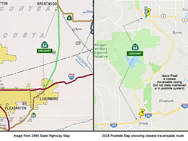 Route 580 in Livermore to Route 4 near Brentwood.
Post 1964 Signage History▸In 1963, this segment was defined as "(e) I-580 to Route 4 near Brentwood."
▸In 1988, Chapter106 changed this to "I-580 in Livermore."
The corridor of Vasco Road never saw a formal route addition for Route 84. Vasco Road was last explored seriously as a State Highway
corridor as part of the conceptual Mid-State Tollway (see below).
The Mid-State Tollway would have originated at I-680 near Sunol and
extended towards Route 4 via the general corridor of Vasco Road.
(Source: Gribblenation Blog (Tom Fearer), "Vasco Road (planned California State Route 84)", 5/4/2023)
During 1996 a 12.8-mile segment of Vasco Road was relocated reference #3)
and expanded to expressway standards. The driving force for the
relocation of 12.8-miles of Vasco Road was construction of Los Vaqueros
Reservoir which would flood much of the original highway. The
original alignment of Vasco Road was partially repurposed into what is now
Los Vaqueros Road and Walnut Boulevard.
(Source: Gribblenation Blog (Tom Fearer), "Vasco Road (planned California State Route 84)", 5/4/2023)
Pre 1964 Signage HistoryThis was an extension to LRN 108 defined in 1959. It was not part of the original state signage in 1934, but was signed by 1963.
Vasco Road is a 17.7-mile roadway spanning the northern Diablo Range
beginning at Route 4 in Brentwood of Contra Costa County south to Tesla
Road/Alameda County Sign Route J2 in Livermore. Vasco Road appears on the 1935
Division of Highways Maps of Contra Costa County and Alameda County as a
major local highway. During 1957 and 1958 the city of Livermore
extended Vasco Road south from US 50 to Tesla Road. The corridor of Vasco
Road was added to the State Highway System as part of an extension of LRN 108 by way of 1959 Legislative Chapter 1062. Specifically, LRN 108
was extended from Livermore to a new terminus in Brentwood. The
corridor of LRN 108 between Livermore and Brentwood was added to the
Freeway & Expressway System upon being defined.
(Source: Gribblenation Blog (Tom Fearer), "Vasco Road (planned California State Route 84)", 5/4/2023)
StatusCaltrans documentation from 1994 indicates that the unconstructed portion is from I-580 to Route 4, and from W of Livermore to I-580, replacing the traversible highway. When this 5 mile stretch is constructed, it will reduce the total length of the route to 107 miles. The Route 4 bypass was being construction over portions of Route 84, although most of legislative Route 84 is Vasco Road. However, it appears the bypass was assigned to Route 4.
The 2013 Traversable Highways report indicates that the Route 4 bypass referred to in previous reports has been completed and adopted into the SHS. Route 4 intersects with the traversable highway for Route 84 at the intersection of Vasco Road and Marsh Creek Road.
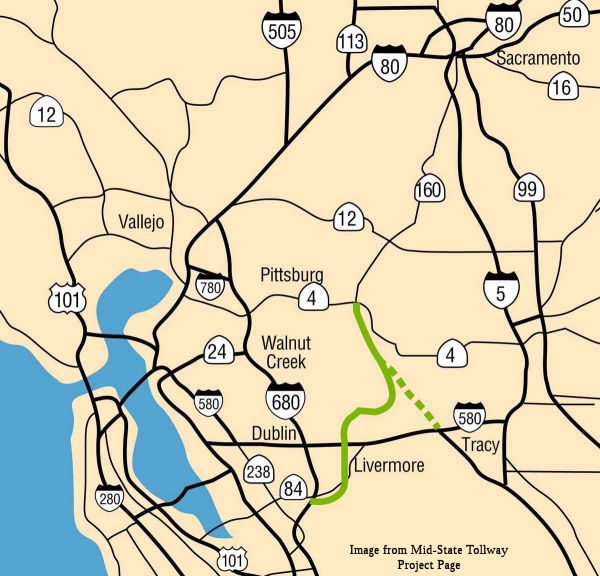 There are some who believe that this section may be used to create the Mid State
Tollway. The tollway is a proposal that would start off of I-680
near Sunol, cross I-580 west of Livermore (roughly along the alignment of
the Livermore Bypass), and then will extend north to Route 4 near Antioch.
A spur will come off the tollway near Brentwood and run SE to the junction
of I-580 and I-205. The tollway could be designated Route 84, since it
roughly follows the built and unbuilt portions of the route and the spur
could be designated Route 239, since it follows the general routing for
that unbuilt highway. The tollway was originally supposed to extend to
I-80 between Vacaville and Dixon with a spur connecting with I-505 at the
80/505 junction, but that portion was killed due to the need for
high-level crossings (150') of the San Joaquin and Sacramento Rivers plus
environmental issues.
There are some who believe that this section may be used to create the Mid State
Tollway. The tollway is a proposal that would start off of I-680
near Sunol, cross I-580 west of Livermore (roughly along the alignment of
the Livermore Bypass), and then will extend north to Route 4 near Antioch.
A spur will come off the tollway near Brentwood and run SE to the junction
of I-580 and I-205. The tollway could be designated Route 84, since it
roughly follows the built and unbuilt portions of the route and the spur
could be designated Route 239, since it follows the general routing for
that unbuilt highway. The tollway was originally supposed to extend to
I-80 between Vacaville and Dixon with a spur connecting with I-505 at the
80/505 junction, but that portion was killed due to the need for
high-level crossings (150') of the San Joaquin and Sacramento Rivers plus
environmental issues.
The EIR for Lawrence Livermore
National Laboratory noted the following regarding the project: "The
Mid-State Tollway project involves a conceptual proposal for an 85-mile
tollway connecting the Fremont area with the I-80 corridor near Vacaville,
and the I-5 corridor, via I-580, with the I-80 corridor near Vacaville.
These connections are proposed to occur approximately midway between I-680
and I-5. The Mid-State Tollway construction is projected to begin in 1994
and be completed in the late 1990s. "
(Source: Environmental Impact Statement and Environmental Impact Report for Continued Operation of Lawrence Livermore National Laboratory and Sandia National Laboratory, 1992)
This project was later reduced in scope to a $600
million, 40+ mile, initial four lane (ultimate 6-lane) toll road extending
from Route 680 near Sunol to Route 4 near Antioch. The project developer,
California Toll Road Company (CTRC), and Caltrans amended the original
franchise agreement in 1993 to delete the portions of the original project
that included an extension into Solano County. This amendment satisfied a
condition imposed by the Metropolitan Transportation Commission (MTC) in
its review of the proposed transportation project. Work on the project was
suspended due to serious political opposition and the franchise terminated
on January 1, 2001
(Source: Mid-State Tollway Project Page)
On AAroads, Sparker noted that the tollway would have
required twinning of the Antioch Bridge and a second high-level crossing
of the Sacramento River several miles north. Much of the proposed
alignment of the western Mid-State "branch" follows what has been
suggested for a Route 84 extension north to Route 4 near Brentwood; the
south(west) terminus of that branch was to have been the present Route 84/Route 680 interchange at Sunol; the eastern branch would have tracked
the proposed Route 239 alignment, terminating at the I-580/I-205 Altamont
interchange. The branches came together slightly south of the present
Route 4/Vasco Road intersection between Brentwood and Discovery Bay and
utilized Route 4 as a "free" connector between that point and the Antioch
Bridge, where the tolled section would have resumed north toward Vacaville
and Davis. Again, the facility was planned to split into two branches to
separate termini -- one on I-505 just north of Vacaville and the other at
the I-80/Route 113 (north) freeway interchange near Davis. Planning for
this commenced circa 1991-92; included in the concept was a cable-stayed
4-lane bridge over the Sacramento River directly north of the present
Antioch Bridge. Opponents included a large contingent of tomato farmers in
the Dixon-Elmira area, which the facility would have bisected, the Alameda
County planning department and the county board of supervisors, and UC
Davis. Studies persisted for about 5 years and were shelved circa 1998;
funding for the planning efforts were withdrawn in late 2001.
(Source: Sparker on AAroads, "Re: I-505", 2/26/2019)
Scott Parker noted on AAroads that the tollway would
have utilized the path of the oft-considered Route 239, Route 4 between
Byron and Antioch, the Antioch (Route 160) bridge, and diverged from Route 160 north of there to cross the Sacramento River. It would have had
terminating "splits" at both ends; a Route 84-based branch along Vasco
Road, passing between Livermore and Pleasanton, and terminating at the
Route 84 interchange with I-680 was to be a SW branch, while the main
trunk, after crossing the Sacramento River, would have headed toward
Elmira, where it would split into two branches, one intersecting I-505
about a mile or two north of I-80 (after crossing the latter freeway) and
the other heading toward Dixon and the I-80/Route 113 freeway interchange
between Dixon and Davis -- the Route 113 freeway would have been its
functional extension. The toll road idea, formulated in the late '80's and
early '90's, would have required a doubling of the Antioch Bridge as well
as a 4-lane high-level bridge (likely cable-stayed) across the Sacramento
River north of there. Even in 1992, the cost for doing the full project
was projected at well over $2 billion; with the center section along Route 4 remaining a free facility (the present Antioch Bridge toll facility
would have marked the southern end of the northern toll section). The
Route 84 branch was itself mired in controversy; in the '90's the
development of the Brentwood area as an "overflow" housing region for
Silicon Valley employment was in its initial stages; deploying a toll road
to serve that commute traffic was seen as gratuitous money-grubbing and
that a conventional freeway would be more appropriate. But by 1998 the
entire project was functionally scrapped because of the enormous cost;
projected toll revenue was far too meager to even cover the initial
construction -- likely due to the myriad opportunities for shunpiking as
well as the perception that the northern section had limited commuter
value and what revenue would accrue would come from commercial usage --
the most likely candidates to avoid the tolled facility!
(Source: AARoads "Re: I-5 West Side Freeway", 12/29/2019)
Freeway [SHC 253.5] Entire portion; unconstructed. Added to the Freeway and Expressway system in 1959.
 Interregional Route
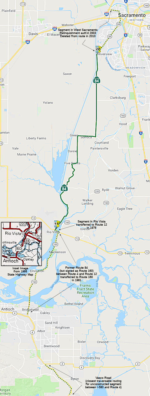 From Route 12 at Rio Vista to the southerly city limit of the City of West
Sacramento.
From Route 12 at Rio Vista to the southerly city limit of the City of West
Sacramento.
(b) The relinquished former portion of Route 84 within the City of West Sacramento is not a state highway and is not eligible for adoption under Section 81. For the relinquished former portion of Route 84, the City of West Sacramento shall maintain signs within its jurisdictions directing motorists to the continuation of Route 84.
Post 1964 Signage HistoryIn 1963, this segment was defined as " (f) Route 4 near Antioch to Route 80 near Broderick via the vicinity of Rio Vista and via Ryer Island." Note that at this time, "Route 80" referred to the current US 50.
In 1965, Chapter 1372 extended the terminus of this segment to "Route 880 near Bryte via the vicinity of Rio Vista and via Ryer Island." Route 880 at this time is the current I-80.
In 1976, Chapter 1354 split (f) into two segments: "(f) Route 4 near Antioch to Route 12 near Rio Vista. (g) Route 12 near Rio Vista to Route 880 near Bryte via Ryer Island." (again, note that Route 880 is current Route 80). This transfered the segment within Rio Vista to Route 12.
In 1981, Chapter 292 deleted (f), and clarified the remaining segment"(f) Route 12 at Rio Vista to Route 80 near Bryte via Ryer Island." It also renumbered Route 880 to Route 80. The former (f) was transferred to Route 160.
In 2003, SB 104, Chapter 5, 4/21/2003, authorized relinquishment in West Sacramento: Note that the California Transportation Commission may relinquish the portion of Route 84 within the City of West Sacramento to that city upon terms and conditions that the commission finds to be in the best interests of the state, per SB 104, chaptered 4/21/2003 (Chapter 5). For those portions of Route 84 that are relinquished, the City of West Sacramento agrees to maintain signs within its jurisdiction directing motorists to the continuation of Route 84 as a condition of the relinquishment. After relinquishment, the last segment of Route 84 shall be defined as "Route 12 at Rio Vista to the southerly city limit of the City of West Sacramento. The relinquishment may happen fast, as it is already on the May 2003 CTC Agenda. This is evidenced by the fact that West Sacramento wants an allocation of $6.199M, but is willing to take over maintenance and ownership immediately, and defer receiving the funds until June 2006.
In 2010, Chapter 421 changed the terminus from "Route 80 near Bryte via Ryer Island" to "the southerly city limit of the City of West Sacramento" and updated the relinquishment words.
Sparker on AAroads provided some interesting insights into this segment:
Originally, Route 84 was legislatively commissioned over that part of
signed Route 160 from Route 4 north to Route 12 as part of the 1964
renumbering. The entire route -- both existing parts being the "end
pieces" of that route -- was envisioned as an alternate/scenic route from
the coast south of S.F. to the Sacramento area, including a connector more
or less on the Vasco Road alignment between Alameda and Contra Costa
Counties. Somewhere along the line (~ the early '80's) Caltrans must have
realized that the concept was unworkable as a through route (Caltrans
being generally multiplex-adverse, the long coincidences with I-580 and CA 4 probably contributed to that conclusion), and that portion from Antioch
to Rio Vista was assigned to Route 160 as long-signed.
(Source: Sparker on AAroads, "Re: CA 84/Real McCoy Ferry and CA 220 J Mack Ferry", 12/18/2018)
Pre 1964 Signage HistoryThis was LRN 99 between Route 12 and US 50, and was defined in 1933. The remainder of the route was not defined until 1965. It was not signed before 1964. It runs along Jefferson Blvd in West Sacramento.
StatusPartially signed from Route 12 to Sacramento.
Ryer Island Ferry / "Real McCoy" (~ SOL 1.899)
The route includes the Ryer Island Ferry "The Real McCoy" on Cache Slough (~ SOL 1.899), which is signed as Route 84. The Real McCoy used to be a cable ferry, but it was retrofitted as a diesel powered boat in the early 1960s when the Sacramento River Deep Water Ship Channel was constructed and Cache Slough was deepened as part of the Ship Channel. They didn't want freighters severing the cable.
In 2009, it was reported that the river ferry is being updated. On January 11, 2009, "The Real McCoy", a 62-year-old twin-propeller boat that serves as part of Route 84 was taken out of service. It returned to service in February 2009. Normally the ferry run round the clock, stopping only for twice-daily 20-minute lunch breaks, when river conditions make it unsafe to operate, or when something breaks down and needs fixing, which has been happening often. Caltrans plans to replace the Real McCoy, a flat-bottom, double-ended ferry powered by two engines and propellers that can be turned 360 degrees, but with the state budget crisis threatening funding for transportation projects, it's not certain when. So the ferry will head to dry-dock, where it will get two new engines, a new electrical system, other mechanical fixes and a fresh coat of paint. It was the first dry dock service in eight years for the ferry, whose twin six-cylinder service engines sprung leaks and its hulls were dented from bumping into docks. The Real McCoy carries about 300 to 400 vehicles a day, crossing the river about 200 times.
In January 2011, a new ferry that will replace the 65-year-old Rio Vista ferry arrived in Alameda. In February 2011, the $4.3 million Real McCoy II ferry will take over from the aging Real McCoy ferry on Route 84 at Ryer Island near Rio Vista in Solano County.
In September 2011, it was reported that there were numerous problems with the new ferry. It was taken out of service on September 9, 2011, and Caltrans is still working with the boat builder to determine why the vessel keeps breaking down. Engineers have replaced three sets of 6,000 PSI hydraulic hoses. The hoses or fittings failed in each incident, leading to a loss of control. Caltrans has instructed Nichols Bros. to come up with an "action plan" to put the ferry back into service. Caltrans is committed to solving the hydraulic problem before the warranty expires at the beginning of next year. Caltrans continues to pick up the tab for an operator on board the ferry around the clock in case an emergency crossing is required. With the ferry idled, several hundred residents of Ryer Island have been forced to take a long detour to get to Rio Vista and the rest of Solano County. What should be an 800-foot trip across Cache Slough takes travelers more than 23 miles out of their way.
At the end of September 2019, it was reported that the
ferry over the Cache Slough at Route 84, also called the Real McCoy Ferry,
has suffered a structural failure and will be out of commission until the
later part of November 2019.
(Source: CBS Sacramento, 9/30/2019)
In December 2019, it was reported that the Real McCoy
Ferry may return to service in January 2020. The Real McCoy II Ferry on
Route 84 went out of service in late September due to structural failure
in the hull. A boat repair company was immediately hired, but there was no
room at a repair facility that could accommodate the Real McCoy. Repair
work began the week of Nov. 4. Additional issues were discovered that
delayed the Real McCoy’s return to service until approximately the
end of January.
(Source: Daily Republic, 12/13/2019)
Miner Slough Bridge (04-Sol-84 12.0/12.4)
In March 2018, the CTC approved for future
consideration of funding the following project for which a Mitigated
Negative Declaration (MND) has been completed: Route 84 in Solano County.
Replace or rehabilitate an existing bridge on Route 84 near the city of
Rio Vista (04-Sol-84, PM 12.0/12.4). (PPNO 0886). The project is located
near the city of Rio Vista on Route 84 in the county of Solano. The bridge
connects Ryer Island in the Sacramento-San Joaquin River Delta to the
mainland. The project proposes to replace or rehabilitate the Miner Slough
Bridge with a new fixed span and new vertical clearance over the slough to
accommodate sea level rise. The project is fully funded and programmed in
the 2016 SHOPP for an estimated total of $38.5 million, which includes
Construction (capital and support) and Right-of-Way (capital and support).
Construction is estimated to begin in 2019. The scope, as described for
the preferred alternative, is consistent with the project scope programmed
by the Commission in the 2016 SHOPP.
(Source: CTC Agenda, March 2018 Agenda Item 2.2c(1))
The following project was included in the final adopted 2018 SHOPP in March 2018: PPNO 0886. 04-Solano-84 12.0/12.4. On Route 84 Near Rio Vista, at Miner Slough Bridge № 23-0035. Replace bridge. Begin Con: 12/20/2020. Total Project Cost: $38,482K.
In October 2022, the CTC amended the following project
in the SHOPP: 04-Sol-84 12.0/12.4. PPNO 04-0886; ProjID 0400000343; EA
0G660. Route 84 Near Rio Vista, at Miner Slough Bridge № 23-0035.
Replace bridge. Allocation ($ × 1,000): PA&ED $0; PS&E
$2,291; R/W Sup $800; Con Sup $8,000; R/W Cap $2,800; Const Cap $44,400;
TOTAL $58,291. Begin Const: 6/15/2026.
(Source: October 2022 CTC Agenda, Agenda Item
2.1a.(1b) #1)
In October 2022, the CTC approved the following
pre-construction phase allocation: $3,091,000. 04-Sol-84 12.0/12.4. PPNO
04-0886; ProjID 0400000343; EA 0G660. Route 84 Near Rio Vista, at Miner
Slough Bridge № 23-0035. Replace bridge. Allocation: FY25-26
PS&E $2,291,000; R/W Sup $800,000. Future consideration of funding
approved under Resolution E-18-17; March 2018. Concurrent Amendment under
SHOPP Amendment 22H-004; October 2022. As part of this allocation request,
the Department is requesting to extend the completion of the PS&E Sup
phase an additional 7 months beyond the 36 month deadline. As part of this
allocation request, the Department is requesting to extend the completion
of the R/W Sup phase an addtitional 26 months beyond the 72 month
deadline.
(Source: October 2022 CTC Agenda, Agenda Item 2.5b.(2b) #7)
In September 2010, the CTC approved relinquishment of right of way in the city of West Sacramento along former Route 84 (Jefferson Blvd.), from Linden Road to 13th Street (3-Yol-84-PM 19.7/21.4), consisting of collateral facilities.
Named Structures Bridge 22-0176 in Yolo County (in West Sacrament, since relinquished) is named the "Arthur H. Edmonds
Underpass". It was named by Assembly Concurrent Resolution 135,
Chapter 162 in 1982. Arthur H. Edmonds, a Yolo County Supervisor from 1966
to 1981, was the principal proponent for the extension of Route 84 from
West Sacramento to east Yolo County. Edmonds was born in September 1923 in
Deertrail, Colorado. During World War II, Edmonds served in the U.S. Navy
and was stationed in the Aleutian Islands. After an honorable discharge,
Art graduated from Sacramento Junior College and was in the first
graduating class at Sacramento State College. During college, he began
working in the flooring business and worked many years at Ring-Up Rivett
(a flooring and flooring contractor since 1850), in Sacramento. He also
had several businesses with his sister and brother-in-law, Hilda and
Ernest Dorris, and later with his nephews Richard and John Dorris.
In 1966, Art was elected to the Yolo County Board of Supervisors and
served for 14 years, representing the West Sacramento area. While serving
as a Yolo County Supervisor, Art served as President of the California
State Association of Counties and was on the Board of Directors of the
National Association of Counties. He also served on the Yolo County
Democratic Central Committee. Over the years, Art was a member of many
organizations including Rotary Club, Lions, the Over- the-Hill Gang and
was a 50- year member of Scepter Lodge #143 F & AM. He was also a
lifetime member of the Dante Club and VFW Post 8762 and was a past
President of the West Sacramento Little League. In his spare time he
enjoyed golfing, hunting, was an avid Giants fan and a long time 49er
season ticket holder. He died on June 3, 2015 in West Sacramento.
Bridge 22-0176 in Yolo County (in West Sacrament, since relinquished) is named the "Arthur H. Edmonds
Underpass". It was named by Assembly Concurrent Resolution 135,
Chapter 162 in 1982. Arthur H. Edmonds, a Yolo County Supervisor from 1966
to 1981, was the principal proponent for the extension of Route 84 from
West Sacramento to east Yolo County. Edmonds was born in September 1923 in
Deertrail, Colorado. During World War II, Edmonds served in the U.S. Navy
and was stationed in the Aleutian Islands. After an honorable discharge,
Art graduated from Sacramento Junior College and was in the first
graduating class at Sacramento State College. During college, he began
working in the flooring business and worked many years at Ring-Up Rivett
(a flooring and flooring contractor since 1850), in Sacramento. He also
had several businesses with his sister and brother-in-law, Hilda and
Ernest Dorris, and later with his nephews Richard and John Dorris.
In 1966, Art was elected to the Yolo County Board of Supervisors and
served for 14 years, representing the West Sacramento area. While serving
as a Yolo County Supervisor, Art served as President of the California
State Association of Counties and was on the Board of Directors of the
National Association of Counties. He also served on the Yolo County
Democratic Central Committee. Over the years, Art was a member of many
organizations including Rotary Club, Lions, the Over- the-Hill Gang and
was a 50- year member of Scepter Lodge #143 F & AM. He was also a
lifetime member of the Dante Club and VFW Post 8762 and was a past
President of the West Sacramento Little League. In his spare time he
enjoyed golfing, hunting, was an avid Giants fan and a long time 49er
season ticket holder. He died on June 3, 2015 in West Sacramento.
(Information source: Obituary; Image source: UCR Digital Newspaper Collection)
Freeway[SHC 253.5] From Route 12 at Rio Vista to Route 50 near Broderick: unsigned. Added to the Freeway and Expressway system in 1959.
 Classified Landcaped Freeway
The following segments are designated as Classified Landscaped Freeway:
| County | Route | Starting PM | Ending PM |
| Alameda | 84 | R3.09 | R3.35 |
| Alameda | 84 | R3.85 | R4.10 |
| Alameda | 84 | R4.32 | R5.76 |
 Exit Information
 Other WWW Links Post 1964 Signage History
As defined on July 1, 1964, parts (6) and (7) were continuous (i.e., from Route 4) and ended at I-80 (present-day US 50, a/k/a unsigned I-305). In 1965, the portion from I-80 (present-day US 50, a/k/a unsigned I-305) to I-880 (present-day I-80) was added, making the route continuous from Route 4 to I-880 (present-day I-80); this section was formerly part of Route 16. In 1976, parts (6) and (7) were made discontinuous when the portion from Route 160 to Route 12 in Rio Vista was transferred to Route 12, leaving part (6) running to the new terminus of Route 12 (former Route 160). In 1981, the portion of part (6) from Route 4 near Antioch to Route 12 near Rio Vista was transferred to Route 160.
Pre 1964 Signage HistoryRoute 84 was not defined as part of the initial state signage of routes in 1934. It is unclear what (if any) route was signed as Route 84 between 1934 and 1964.
 Statistics
Overall statistics for Route 84:
 Pre-1964 Legislative Route
The route that became LRN 84 was defined in 1933 as the route from "[LRN 20] near Willow Creek to [LRN 46] near Weitchpec." It was codified in 1935 into the highway code with this definition, and the definition remained unchanged until 1963.
This was signed as Route 96, but was not the original alignment of Route 96 (which was the route from Klamath to Weitchpec, and then the present route to US 99 (I-5). The resigning of Route 96 to include LRN 84 occured sometime between 1939 and 1963.
© 1996-2020 Daniel P. Faigin.
Maintained by: Daniel P. Faigin
<webmaster@cahighways.org>.
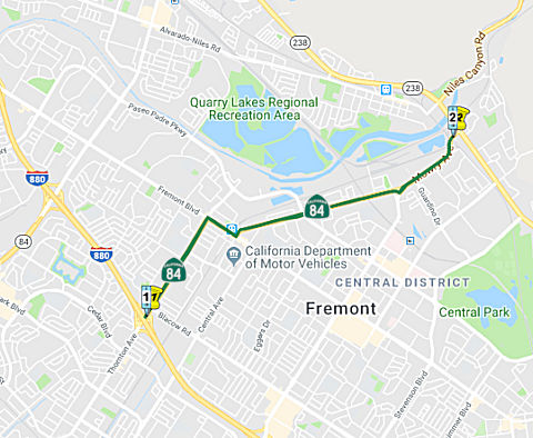 Route
Route  Route 83
 Route 85