
 California Highways:
Click here for a key to the symbols used. An explanation of acronyms may be found at the bottom of the page.
 Routing
 Post 1964 Signage History
This segment remains as defined in 1963.
The first section of I-405 opened in 1957, signed as Route 7. One of the earliest sections was in West Los Angeles, from Bellagio Rd to Santa Monica Blvd. The part west of I-605 was done before 1965. The segment between Beach Blvd and Harbor Blvd in Costa Mesa opened in 1966. Construction also included the interchange with Route 55. The newest section, near the southern junction with I-5, opened in 1969.
The following freeway-to-freeway connections were never constructed:
 Pre 1964 Signage History
This routing was LRN 158. The portion from I-5 in Orange County to Route 710 was defined in 1951; the portion from Route 710 to Route 90 was defined in 1947; and the portion from Route 90 to I-5 in San Fernando was defined in 1933.
Before the freeway was constructed, LRN 158 also applied to pre-1963 Route 7 between Route 107 and the US 99/US 6 junction.
 In 1952, the CHC disclosed plans to extend the "Sepulveda
Freeway" (Route 7) from Inglewood to a junction with US 101 (I-5) in
Orange County. The Sepulveda extension was in an entirely new location
intended to provide traffic relief for a congested area.
In 1952, the CHC disclosed plans to extend the "Sepulveda
Freeway" (Route 7) from Inglewood to a junction with US 101 (I-5) in
Orange County. The Sepulveda extension was in an entirely new location
intended to provide traffic relief for a congested area.
(Source: Los Angeles Times, 12/20/1952 via Joel Windmiller,
2/19/2023)
No Specific History
The I-405/I-605 interchange was designed by Carol Schumaker.
Scott Parker (SParker) on AAroads noted: "[By 1957,] the only sections of
the proposed route in L.A. County that were not already seeing large-scale
development were the section over the Santa Monica mountains and the
segment between the Long Beach (current I-710) and Harbor (again, now
I-110) freeways, which was in the '50's largely occupied as "tank farms"
by several oil companies (Getty Oil owned a large portion of what is now
the city of Carson). Otherwise, by 1955 the sections from Gardena north to
West L.A. were occupied by housing -- although since that alignment had
been adopted by '56, only a few early tracts in Lawndale and Torrance had
to be razed to accommodate the freeway; a ROW had been reserved for the
remainder. The same applied to North Long Beach, but as an older
residential area, more developed property had to be obtained for the
freeway. Only in Fountain Valley within O.C., and what is now Irvine
southeast of Route 55, was there considerable open/undeveloped land (the
latter owned by the Irvine Company, a family business). I-405 was always
considered an "alternative" rather than a classic "bypass" by the Division
of Highways and later Caltrans, as it served one of the major California
cities (Long Beach) as well as several other coastal regional centers
(Torrance, Redondo Beach) from which I-5 remained at a distance."
(Source: Scott Parker (SParker) on AAroads, "Re: I-405 widening in Orange County has started", 1/24/2019)
Scott Parker (SParker) on AAroads noted: "The initial construction on
I-405 actually started shortly before the Interstate era as a freeway
upgrade to then Route 7 (LRN 158) between Culver City and the Santa Monica
Mountains; that segment opened to traffic at the end of 1957 with Route 7
signage; that was replaced by that summer with I-405 signage." Note that
this means the Route 7 signage on this section existed for perhaps 5-6
months at best.
(Source: Scott Parker (SParker) on AAroads, "Re: I-405 widening in Orange County has started", 1/24/2019)
![[Reece at 405-10]](images/reece.jpg) The I-405/I-10 interchange was designed by Marilyn
Jorgenson Reece, who was the first woman in California to be registered as
a civil engineer. She died in May 2004. A South Dakota native who earned a
bachelor's degree in civil engineering from the University of Minnesota in
1948, Reece moved to Los Angeles with her parents shortly after
graduation. The same year, she went to work for the State Division of
Highways, which later became Caltrans, as a junior civil engineer in Los
Angeles. In 1954, after six years of required experience to sit for the
Professional Engineer's Exam, Reece became the state's first fully
licensed female civil engineer. In 1962, she received the Governor's
Design Excellence Award from Gov. Pat Brown for the San Diego-Santa Monica
freeway interchange. Shortly after, Reece became the Division of Highway's
first woman resident engineer for construction projects. The three-level
San Diego-Santa Monica freeway interchange, which opened in 1964, was the
first interchange designed in California by a woman engineer. Reece told
The Los Angeles Times in 1995 that she put her "heart and soul into it"
and that she designed the interchange with aesthetics in mind. "It is very
airy. It isn't a cluttered, loopy thing," she said, adding that
specifications to keep traffic moving at high speeds necessitated the
long, sweeping curves. The image to the right, excerpted from One
Hundred Years of Progress, shows Reece and Thomas McKinley. However,
the book referred to Reece as an Associate Engineer, with McKinley as a
Resident Engineer, but did indicate that Reece supervised the I-405/I-10
interchange project. The view in the photo is looking N from what is
roughly the National offramp on the I-405; you can see a sign for the
Route 26 Olympic Blvd NB offramp that was removed as part of the project
(likewise, the SB National offramp was removed). A nice profile of Ms. Reece may be found on the LA Daily Mirror blog. She is also profiled in the Transportation History blog.
The I-405/I-10 interchange was designed by Marilyn
Jorgenson Reece, who was the first woman in California to be registered as
a civil engineer. She died in May 2004. A South Dakota native who earned a
bachelor's degree in civil engineering from the University of Minnesota in
1948, Reece moved to Los Angeles with her parents shortly after
graduation. The same year, she went to work for the State Division of
Highways, which later became Caltrans, as a junior civil engineer in Los
Angeles. In 1954, after six years of required experience to sit for the
Professional Engineer's Exam, Reece became the state's first fully
licensed female civil engineer. In 1962, she received the Governor's
Design Excellence Award from Gov. Pat Brown for the San Diego-Santa Monica
freeway interchange. Shortly after, Reece became the Division of Highway's
first woman resident engineer for construction projects. The three-level
San Diego-Santa Monica freeway interchange, which opened in 1964, was the
first interchange designed in California by a woman engineer. Reece told
The Los Angeles Times in 1995 that she put her "heart and soul into it"
and that she designed the interchange with aesthetics in mind. "It is very
airy. It isn't a cluttered, loopy thing," she said, adding that
specifications to keep traffic moving at high speeds necessitated the
long, sweeping curves. The image to the right, excerpted from One
Hundred Years of Progress, shows Reece and Thomas McKinley. However,
the book referred to Reece as an Associate Engineer, with McKinley as a
Resident Engineer, but did indicate that Reece supervised the I-405/I-10
interchange project. The view in the photo is looking N from what is
roughly the National offramp on the I-405; you can see a sign for the
Route 26 Olympic Blvd NB offramp that was removed as part of the project
(likewise, the SB National offramp was removed). A nice profile of Ms. Reece may be found on the LA Daily Mirror blog. She is also profiled in the Transportation History blog.
In the improvement of the San Diego Freeway through the Veterans Administration Center, it was necessary to acquire property in the name of the County of Los Angeles for the realignment of Wilshire Boulevard and for the widening of Federal Avenue, the reconstruction of which has been carried out by the State Division of Highways. The necessary grants of property from the Federal Government were secured under the provisions of Section 17 of the Federal Highway Act of November 9, 1921, as amended, 42 Statutes 216. The Federal Government transferred a total of 54.2 acres of which 46.6 acres was to the State of California for the San Diego Freeway, and 7.6 acres was to County of Los Angeles for the improvement of Wilshire Boulevard and Federal Avenue. The State and county received from the Federal Government for this project land worth well in excess of $2,000,000. The State, in return, has carried out considerable construction and relocation work for the benefit of the veterans' facility. The grant to the County of Los Angeles provided for the vacation of San Vicente Boulevard by the County of Los Angeles through the Veterans Administration Center whereby 6.6 acres would be added to the usable area of the veterans' facility.
As for Sepulveda Canyon, Sepulveda Blvd, and I-405: For centuries the
region’s native Tongva people had hiked a faint footpath through
Sepulveda Canyon, and in 1769 the soldiers and clergy of Spain’s
Portola expedition followed that ancient trade route on their way to
Monterey. Trail became road in 1875, when the two wheat barons of the San
Fernando Valley, Isaac Lankershim and Isaac Newton Van Nuys, widened the
footpath to allow for the passage of sturdy wagons laden with grain and
bound for ships docked at the Santa Monica Pier. But when the Southern
Pacific soon lowered its freight rates, the wheat ranchers instead sent
their harvest by train to San Pedro. The new, neglected road eroded into
the hillsides. Development in the San Fernando Valley during the 1920s
persuaded the city and county to rebuild the road for automobiles. Traffic
was overwhelming the two established routes between the Valley and the
Basin, Cahuenga Pass and San Fernando Road, both of which were out of the
way for residents of faraway Van Nuys and Owensmouth.
(Source: KCET, 6/27/2017. The article has loads of great historical photos.)
In 1923, Los Angeles City Planner Gordon Whitnall developed a long range
master plan for the city. He advocated and oversaw the building of Beverly
Boulevard, Whittier Boulevard, and the Second Street tunnel. He was a
crucial booster behind the conception of Sepulveda Canyon Boulevard, which
evolved into I-405. The canyon was western boundary of Bel Air, and was
acquired by Alphonzo E. Bell as part of the 22,000 acre purchase of Bel
Air. In November 1923, it was reported there was a plan to extend
Sepulveda Blvd through the canyon—clearly a reference to Whitnall's
plan.
(Source: KCET Lost Landmarks, 6/28/2013; FB Photo of 11/23/1923 article, 4/11/2021)
New Sepulveda Canyon Boulevard – a 50-mile highway stretching
between San Fernando and Long Beach – would provide the Valley with
a more direct link to the Basin and harbor beyond at San Pedro Bay.
Construction lasted several years and culminated with the opening of a
650-foot tunnel beneath the summit at Mulholland Drive, an event the city
celebrated with a grand Spanish-style fiesta. Despite the festivities, by
the time traffic started flowing in September 1930, the new Sepulveda
Canyon Road was already inadequate. Five years later the state spent
$275,000 to pave it, and by the late 1950s traffic engineers developed a
new construction project that just might keep traffic flowing freely over
Sepulveda Pass: Tear Sepulveda Canyon apart and then rebuild it to allow a
superhighway to pass through. Beginning in August 1960, earthmovers carved
a gorge 1,800 feet wide and 260 feet deep through the mountains,
accomplishing in two years what might take natural erosional forces two
million. The bulldozers' total haul: 13 million cubic yards of slate,
shale, and dirt. Workers then built massive retaining walls to keep the
unnaturally steep slopes from slipping and reconfigured the area's natural
drainage through a series of culverts. By 1962, an eight-lane concrete
freeway with a maximum grade of 5½% sliced through the mountains.
(Source: KCET, 6/27/2017. The article has loads of great historical photos.)
Construction on I-405 (the "Sepulveda Freeway") in West Los Angeles begin in 1954. CHPW noted in November-December 1953, "Los Angeles County, structures on the route of the Sepulveda Freeway, between Waterford Street and Casiano Road in West Los Angeles, $800,000 (first construction on the Sepulveda Freeway)." Construction started with the original bridges at Sunset Blvd. The name San Diego Freeway started being used in 1955. The first segment of I-405 opened was the two-mile section of the San Diego Freeway from Ohio Street to Casiano Road. The first plan work on the San Diego Freeway was started by the Engineering Bureau Department of Public Works of the City of Los Angeles under City Engineer Lloyd C. Aldrich in 1939 when it was known as the "Sepulveda Parkway."
 A
November 2010 briefing on the I-405 HOV construction in the Sepulveda Pass included these wonderful photos of the construction of the original
Mulholland Bridge. More photos can be found at the LA Times.
A
November 2010 briefing on the I-405 HOV construction in the Sepulveda Pass included these wonderful photos of the construction of the original
Mulholland Bridge. More photos can be found at the LA Times.
A Metro article on the same bridge noted that the bridge was completed on April 4, 1960. The main portion of Mulholland Drive—westward from the Cahuenga Pass in Hollywood past the Sepulveda Pass—opened in 1924 under a different name: the Mulholland Highway. It was built by a consortium of Hollywood Hills landowners. Their goal was to bring development to the Hollywood Hills and make a few dollars for themselves. In May 1958, the State Division of Highways—this preceded the creation of Caltrans—called for bids on a $10-million highway construction project. Besides closing a 4.1-mile gap in US 101 and funding other work on the San Diego Freeway, the 1958 contract required the relocation of 1.1 miles of Mulholland Drive south. Once moved, Mulholland Drive would cross a new 579-foot-long bridge: Mulholland Drive Bridge. When completed, relocating Mulholland Drive and building Mulholland Drive Bridge cost $1,824,000. In June 1960, bids were opened for a $14-million contract to extend the San Diego Freeway 7.4 miles from Brentwood to Valley Vista Bl in the San Fernando Valley. Mulholland Drive Bridge would finally span a freeway. The original bridge was demolished starting in July 2011.
The segment of I-405 between West Los Angeles and the Valley opened to traffic on December 21, 1962. When it happened, San Fernando Valley realtors took out a full page ad in the Santa Monica Evening Outlook heralding the effect in travel savings and increased accessibility between the valley communities and West LA. Public response to the new freeway was instantaneous as 82,000 motor vehicles diverted from parallel mountain roads to the new facility in the first full day of operation. The Average Daily Traffic on Sepulveda Blvd dropped from 42,000 to 3,000! Peak travel time was cut in half, from 14 minutes to 7 minutes (and many people in 2013 would be ecstatic about a travel time of 15 minutes for the pass!).
According to the LA Times, I-405 in the Sepulveda Pass was a bypass for Sepulveda Boulevard (former Route 7), opened in 1935 and was hailed in the Los Angeles Times as a "new and wondrous highway" over the mountains, vastly superior to the overcrowded Cahuenga Pass and Laurel Canyon. The pre-405 Sepulveda Blvd consisted of numerous hairpin curves, which claimed 65 lives during the 1950s alone. More than 40,000 vehicles a day passed through the tunnel under Mulholland Blvd. Northbound traffic routinely backed up to Sunset Boulevard. The Sepulveda Pass project begin in August 1960. Statistics on the project included: Eighteen million cubic yards of earth removed! Ninety thousand cubic yards of concrete poured! Six million pounds of steel holding it together! A 30-story building could be hidden within the depths of the so-called Big Cut. It was opened on December 21, 1962.
Pictures of the construction of I-405 in the San Fernando Valley may be found here. An article on the geology of the Sepulveda Pass may be found here.
In November 2015, Curbed LA reported on a proposal by the
Libertarian-leaning Reason Foundation to construct a bypass tunnels from
I-10 to US 101. There were three options: From Route 1 to US 101 roughly
along Reseda (roughly the unbuilt portion of Route 14, but with a terminus
at I-10/Route 1), under I-405, or from the termination of Route 187
(Venice) to Laurel Canyon (roughly the unbuilt southern portion of Route 170). The ideal route Reason offers would travel from Santa Monica,
underneath Topanga State Park, to Tarzana. If they have trouble tunneling
through a state park land (spoiler alert: they will), there are two
alternatives—one tunnels under the 405 (note that a tunnel here is
also part of Measure M under consideration in 2016) and the other under
Laurel Canyon. If built, a six-lane tunnel would carry an estimated
109,000 cars per day to and from the valley, producing $9.7 billion in
revenue over 40 years. CurbedLA noted, regarding this proposal, "They're
cute plans, but only a fool would run this bureaucratic marathon for a
transit plan that looks backwards to cars instead of forwards to mass
transit and fossil-fuel-free options." The estimated cost for all their
tunnels would be $700 billion.
(Sources: CurbedLA, 11/17/2015; AARoads Forum, Subject; "What about a tunnel from the end of Glendale Freeway
to Interstate 110?")
 Both sections in the San Fernando Valley (from Burbank to
Nordhoff, and from Nordhoff to I-5) opened to traffic on April 19, 1963.
The original construction of Sepulveda Blvd from San Fernando Road to
Rinaldi/Devonshire occured in 1939.
Both sections in the San Fernando Valley (from Burbank to
Nordhoff, and from Nordhoff to I-5) opened to traffic on April 19, 1963.
The original construction of Sepulveda Blvd from San Fernando Road to
Rinaldi/Devonshire occured in 1939.
 Interesting
historical note: In the May/June 1928 issue of California Highways and
Public Works, there is a discussion of the routing of the Newhall Highway
from Saugus to San Fernando. The article notes: "From a point on the south
roadway near the Cascades it is proposed to extend a new highway south
through the San Fernando Valley and the Santa Monica mountains to the west
coast; there to connect with the state coast highway extending from Oxnard
to San Juan Capestrano"
Interesting
historical note: In the May/June 1928 issue of California Highways and
Public Works, there is a discussion of the routing of the Newhall Highway
from Saugus to San Fernando. The article notes: "From a point on the south
roadway near the Cascades it is proposed to extend a new highway south
through the San Fernando Valley and the Santa Monica mountains to the west
coast; there to connect with the state coast highway extending from Oxnard
to San Juan Capestrano"
 Status
South Orange County Lane Addition (12-Ora-405, PM 0.2/8.7)
In October 2018, the CTC approved for future
consideration of funding the following project for which a Mitigated
Negative Declaration (MND) has been completed: I-405 in Orange County
(12-Ora-405, PM 0.2/8.7). Construct roadway improvements including the
addition of one lane on a portion of I-405 near the cities of Costa Mesa
and Irvine. (MPO ORA13104). This project is located on I-405 near the
cities of Costa Mesa and Irvine in Orange County. The project proposes to
add a single general lane on the mainline freeway and interchanges on
I-405 in both directions from I-5 to Route 55. The project proposes to
improve the high level of congestion on the existing I-405 corridor and
on-off ramps and the current inadequate Intelligent Transportation System
(ITS) infrastructure. The proposed project addresses the existing and
future traffic demand and provides future mobility while minimizing
environmental and economic impacts. The proposed project is currently
programmed and funded through the Project Approval and Environmental
Document (PA&ED) phase for $8.0 million (Surface Transportation Block
Grant funds) in the 2017 Federal Transportation Improvement Program. The
estimated schedule for construction is yet to be determined pending
additional funding for the proposed project.
(Source: October 2018 CTC Agenda Item 2.2c.(1))
In January 2016, the CTC approved SHOPP funding on I-405 in Irvine, Fountain Valley and Seal Beach at Route 133, Brookhurst Street, Warner Avenue, and Seal Beach Boulevard (~ORA 1.758, ORA 13.784, ORA 14.871, and ORA 22.618). Outcome/Output: Widen ramp, overlay connector and ramps with open graded hot mix asphalt, upgrade guardrail and install lighting to reduce the number and severity of collisions. $1,313,000
Sand Canyon Auxiliary Lanes (~ ORA 1.758 to ORA 3.93)
There are plans to add auxiliary lanes from Sand Canyon Road on-ramp to Jeffrey Road (~ ORA 2.887 to ORA 3.907), and from Route 133 to Sand Canyon Road (~ ORA 1.758 to ORA 2.887). July 2005 CTC Agenda.
In May 2013, the CTC received notice that the OCTA would propose delaying the environmental phase of the Route 405 Southbound Auxiliary Lane – Sand Canyon to University project (~ ORA 2.887 to ORA 3.93) to FY 2014-15 in order to align the project with the schedule of an adjacent Route 405 southbound auxiliary lane project. In June 2013, the CTC approved delaying $224,000 in RIP PA&ED from FY 2013-14 to FY 2014-15 for the Route 405 Southbound Auxiliary Lane – University to Sand Canyon project (PPNO 4956) in Orange County.
In August 2014, the CTC authorized $528K for construction of an auxiliary lane on I-405 from University to Route 133 southbound.
The 2018 STIP, approved at the CTC March 2018 meeting, appears to close out PPNO 4956 Auxiliary lane southbound, University-Rt 133, env/PSE.
The following project was included in the final adopted 2018 SHOPP in March 2018: PPNO 4956A. 12-Orange-405 2.4/3.9. On I-405, In Irvine, from Route 133 to Sand Canyon Avenue; also from Sand Canyon Avenue to University Drive/Jeffery Road. Construct southbound auxiliary lanes. Begin Con: 12/1/2019. Total Project Cost: $8,200K.
In April 2019, Caltrans published a commuter alert on
the start of construction for this project. The alert noted that
construction was expected to be completed in January 2020.
(Source: Caltrans District 12 on Twitter, 4/12/2019)
As originally constructed, there were problems with the new HOV connector ramps between I-405 and Route 55 (~ ORA 8.207). It seemed that the bridge had cracks so severe that the bridge might not be able to handle the weight of daily traffic. The estimated repair costs would be 80% of construction costs for this bridge. The bridge was eventually repaired and reopened.
In August 2016, it was reported that Caltrans plans to close Red Hill
Avenue (~ ORA 8.432) to all traffic between Pullman Street in Costa Mesa
and Main Street in Irvine starting at Aug. 29. The bridge is part of that
stretch. It is being shut down for four months of repairs to stabilize the
embankment under one of the approach ramps. The roadway is expected to
remain closed until Dec. 30. The closure is necessary because the earth
under the approach ramp on the Costa Mesa side is moving, which has caused
walls meant to keep the soil in place to bulge slightly and "triggered
progressive pavement cracks on the roadway above," according to Caltrans.
As part of the $9.5-million project, the underlying soil embankment will
be reinforced and new retaining walls will be constructed.
(Source: LA Times, 8/20/2016)
Route 405 Widening - Route 55 to I-605 (Initial Construction) (~ ORA 8.901 to ORA 24.164)
The SAFETEA-LU act, enacted in August 2005 as the reauthorization of TEA-21, provided the following expenditures for this route:
In June 2007, the OCTA outlined a 5-year plan for the use of the 2nd Measure M funds that included adding lanes on Route 91 between I-5 and Route 57 and between Route 55 and the Riverside County border; adding lanes on I-405 between Route 55 and I-605 (~ ORA 8.901 to ORA 24.164); a new NB lane on Route 57 between Orangewood Avenue and Lambert Road.
HOT Lanes - Orange County (Rte 73 to I-605, ~ ORA 10.352 to ORA 24.164)
In February 2010, the Daily Pilot reported that the
Orange County Transportation Authority approved further environmental and
engineering study of a proposal to add high-occupancy toll (H.O.T.) lanes
to I-405 in Orange County between Route 73 and I-605. Specifically, the
proposal proposes to add one general-purpose lane and one H.O.T. lane in
each direction on I-405 between Route 73 and I-605 freeways. There is
already one high-occupancy vehicle lane in each direction that would be
converted into a H.O.T. lane, so it would create a total of two express
H.O.T. lanes in each direction. About $600 million in funding for the
expansion is available from Measure M2 – a ½¢ county sales
tax that pays for transportation improvements – but that is far less
than is needed for even the most modest expansion currently being
considered. The cheapest option being explored is to add one
general-purpose lane in each direction, which would cost $1.7 billion but
would generate no revenue. The most expensive is to add two express lanes
in each direction and charge tolls, which would cost $2.2 billion but
would generate $197 million annually – enough to support the full
cost of the project. The freeway expansion is tentatively slated to begin
in 2016.
(Source: "OCTA approves study of 405 widening project", Daily Pilot, 2/10/2010)
In June 2012, there were public hearings on the plans
to widen I-405 between Route 73 and I-605. Caltrans and the Orange County
Transportation Authority are looking at three alternatives for the San
Diego Freeway, between the Corona del Mar (Route 73) and the San Gabriel
River (I-605) freeways. The first option is to widen the I-405 by adding a
single general-purpose lane in each direction from Euclid Street to I-605.
The second option would do the same thing as the first and also add a
general-purpose lane in the northbound direction from Brookhurst Street to
the Seventh Street exit on Route 22 and a second general-purpose lane
southbound from Seal Beach Boulevard to Brookhurst. The third option would
add one regular lane in each direction of I-405 from Euclid Street to the
I-605 interchange and a tolled express in each direction from Route 73 to
I-605. There also is a no-build alternative. The third option has received
an icy reception in Costa Mesa and Westminster. Seal Beach doesn't want
either the second or third options because both would move a sound wall
closer to the College Park East community. And in Fountain Valley, some
officials are concerned because of the impact on local businesses. Under
the third option, two toll lanes from Route 73 to I-605 would be free to
cars with three passengers most of the time, but there would be a charge
during peak hours. Cars with just a driver or two people would be charged.
A decision is in Summer 2012. Construction is scheduled to begin in 2015
and could last roughly 4½ years. The cost of the project ranges from
$1.3 billion to $1.7 billion, depending on which alternative is chosen.
(Source: OC Register, 6/13/12)
 In August 2012, the CTC reviewed a draft EIR for this
project, and indicated that there were no comments to the Draft EIR, that
the Findings were accepted and that consideration of funding should be
brought forward to the Commission for approval of Design Build funds. The
Draft EIR proposed the following alternatives: (0) No Build Alternative;
(1) Alternative 1 would add one general purpose lane; (2) Alternative 2
would add two general purpose lanes; and (3) Alternative 3 would add one
general purpose lane and one Express Toll Lane. The Toll Express Lane and
the existing High Occupancy Vehicle Lane would be managed jointly as a
tolled Express Lanes Facility with two lanes in each direction.
In August 2012, the CTC reviewed a draft EIR for this
project, and indicated that there were no comments to the Draft EIR, that
the Findings were accepted and that consideration of funding should be
brought forward to the Commission for approval of Design Build funds. The
Draft EIR proposed the following alternatives: (0) No Build Alternative;
(1) Alternative 1 would add one general purpose lane; (2) Alternative 2
would add two general purpose lanes; and (3) Alternative 3 would add one
general purpose lane and one Express Toll Lane. The Toll Express Lane and
the existing High Occupancy Vehicle Lane would be managed jointly as a
tolled Express Lanes Facility with two lanes in each direction.
In September (and again in October) 2012, the OCTA voted against HOT lanes for I-405 in Orange County. The OCTA did approve a $1.3 billion plan that adds one lane in each direction from Euclid Avenue to I-605. The project will be fully funded by Measure M, a half-cent sales tax voters approved in 2006. The board could not gather the votes in favor of the toll system because too many questions remained regarding how the anticipated toll revenue – about $1.5 billion generated over 20 years – would be used. Under the vetoed toll option, existing carpool lanes would be used to create toll express lanes between Route 73 and I-605. That alternative also included adding one general-purpose lane in each direction. In early 2013, the California Department of Transportation will look at three options. The first adds one general-purpose lane in each direction. Cost: $1.3 billion. The second adds two general-purpose lanes each way. Cost: $1.4 billion. A third option adds one general-purpose lane in each direction and a toll lane to the existing carpool lane that will be managed together. Cost: $1.7 billion. OCTA is working closely with Caltrans and anticipates they will concur with the board's selection of alternative 1.
In January 2013, it was reported that several cities
along the I-405 corridor in south Orange County want more widening than
the OCTA approved. They favor a proposal that would add two lanes in each
direction, not just one, at a cost of around $1.4 billion. Voters in 2006
approved the idea of adding one lane in each direction as part of a
package of transportation projects paid for with a half-percent sales tax,
known as Measure M2. Planners later raised two other possibilities. The
first would add two lanes in each direction. The other would add one
normal lane and create two pay-to-ride toll lanes in each direction, in
part by using existing carpool lanes. That last option drew immediate fire
from cities along I-405. Six of them – Costa Mesa, Huntington Beach,
Westminster, Fountain Valley, Seal Beach and Los Alamitos – launched
a $25,000 lobbying effort to derail the toll lanes and push for two new
lanes in each direction. They're considering whether to pool another
$25,000 to keep the fight going. The $1.4 billion cost to add two lanes in
each direction may seem like a short jump from the $1.3 billion estimate
for single lanes, but that's a difference of $100 million. Those who
support the double-lane solution say the money could be found in other
projects. The OCTA board, though, voted 12-4 last fall to support the
less-expensive single-lane project.
(Source: Orange County Register, 1/25/13)
In December 2013, the OCTA approved adding a new lane in each direction of I-405 between the LA County Line and Costa Mesa. No toll lanes.
In July 2014, it was reported that Caltrans is moving
forward with a controversial plan to add toll lanes to I-405 in Orange
County despite strong opposition from nearby cities. The Caltrans plan
incorporates some of the OCTA proposal, but generated opposition because
it adds the toll component and overtakes an existing carpool lane to
create the two HOT lanes in each direction. Caltrans is exploring the
possibility of allowing vehicles with two or more occupants to ride free
in the toll lanes, but a final decision has not been made. Under the plan,
Orange County transit officials would continue with their project adding a
free lane on each side of the 405. When that work is done, Caltrans plans
to build a second new lane on each side. These new lanes, plus two
existing carpool lanes, would then be coverted to HOT lanes for use by
solo drivings willing to pay as well as carpoolers with multiple
passengers.
(Source: Los Angeles Times, 7/25/14)
In June 2015, it was reported that Caltrans District 12
signed the Record of Decision sealing the selection of an improvement
project for the I-405 Freeway through Orange County. Caltrans has chosen
an alternative that adds a general purpose lane to I-405 in each direction
from Euclid Street in Fountain Valley to the I-605 interchange. It also
adds a toll lane in each direction between Route 73 and eastbound Route 22
in Westminster. It also will take the existing carpool lane in each
direction and add it to the tolled Express Lane. The Record of Decision
identifies five intersections in Long Beach with significant impacts from
the expansion. The percentage of cost OCTA is willing to pay for
improvements ranges from 8% to 23%.In April 2014, it was reported that
Orange County transportation officials caved, indicating couldn't fight
the state any longer and had to allow toll lanes as part of a $1.7 billion
expansion project of I-405. The board voted 12-4 to move forward with a
14-mile project to widen I-405 between Long Beach and Costa Mesa by adding
one regular lane and one toll lane in each direction. It also calls for
converting the existing carpool lane into a toll lane. Caltrans will
provide $82 million to subsidize the $400 million price tag for the toll
lanes. The move mirrors decisions by transportation officials in Los
Angeles a few years ago, when they caved in to state officials and added
toll lanes to I-110 and then the I-10 the following year. Under the
project, cars with at least two people will be allowed to use the toll
lanes for free for at least three years. The I-405 construction project
will run from Route 73 in Costa Mesa to I-605 near the Long Beach/Los
Angeles County border. Construction should begin in 2018; it is expected
to take five years to complete. By the year 2040, the expansion is
estimated to shrink commute times in the free lanes between the two areas
from 57 minutes to 29 minutes.
(Source: KPCC 4/27/2015, OCRegister
4/28/2015)
In May 2015, it was reported that the director of
Caltrans District 12 had signed the Record of Decision sealing the
selection of an improvement project for the I-405 Freeway through Orange
County. Caltrans has chosen an alternative that adds a general purpose
lane to I-405 in each direction from Euclid Street in Fountain Valley to
the I-605 interchange. It also adds a toll lane in each direction between
Route 73 and eastbound Route 22 in Westminster. It also will take the
existing carpool lane in each direction and add it to the tolled Express
Lane. Long Beach has fought the project because the freeway expansion
stops at the city’s border, creating a potential bottleneck. Orange
County Transportation Authority officials have argued that the beginning
of I-605 at the county line mitigates the larger I-405 feeding into the
area. The Record of Decision acknowledges Long Beach’s concerns, but
says they have been answered in previous responses. In regards to ongoing
negotiations between Long Beach, OCTA and Caltrans regarding mitigation
payments for repair and upgrades of Long Beach city streets near the
freeway, the document says, “It is anticipated this discussion would
conclude prior to the start of project construction with an agreement.
Caltrans and OCTA are committed to payment of the fair share identified in
the Final EIR/EIS.” That document identifies five intersections in
Long Beach with significant impacts from the expansion. However, the
percentage of cost OCTA is willing to pay for improvements ranges from 8%
to 23% — an amount Long Beach officials have said is inadequate.
(Source: LA Gazette, 5/30/2015)
In August 2015, the CTC approved for future consideration of funding a project in Orange and Los Angeles Counties that will construct improvements on the mainline freeway and interchanges on I-405 between Route 73 and I-605. The project is fully funded. The total estimated cost is $1,782,050,000 for capital and support. The project is programmed in the 2014 State Highway Operation and Protection Program for $82,050,000. The balance is funded with federal and local dollars. Construction is estimated to begin in Fiscal Year 2016-17. The scope, as described for the preferred alternative, is consistent with the project scope programmed by the Commission in the 2014 State Highway Operation and Protection Program. The EIR claims that project effects on the community have been mitigated to the maximum extent predictable but increased urbanization subsequent to the completion of the project and the temporary construction related effects are considered significant and unavoidable. They claim mitigations have been incorporated to address those issues.
In November 2015, it was reported that the OCTA Board
approved the short-listing of four design-build teams (OC 405 Partners,
Orange County Corridor Constructors, Shimmick/Tutor-Perini, and
Skanska-Flatiron) for the design and construction of the I-405 Improvement
Project. The development of the short list is the first of a two-part
process recommended under Assembly Bill (AB) 401, which grants
design-build authority to agencies like OCTA. During the second step, the
short-listed teams will provide feedback on the final request for proposal
as part of an industry review that will assist OCTA in evaluating project
risks and cost drivers. Each team will submit a technical and financial
proposal, and OCTA will choose one contractor based on its findings. The
I-405 Improvement Project will add one general purpose lane in each
direction from Euclid Street to I-605 and add an express lane in each
direction. The new express lane, along with the existing high-occupancy
vehicle lane, would become dual express toll lanes in each direction on
I-405 from Route 73 to I-605.
(Source: OCTA Blog, 11/18/2015)
In March 2016, it was reported that the OCTA Board of
Directors voted on March 14, 2016 to enter into cooperative agreements
with the cities of Costa Mesa, Fountain Valley, Huntington Beach, and
Westminster to provide city services required during the design-build
implementation of the Interstate 405 (I-405) Improvement Project. Because
the project includes improvements to city-owned and operated streets and
will impact some city traffic facilities, a cooperative agreement with
each of the I-405 corridor cities is necessary to define the roles and
responsibilities of each agency during the project’s implementation.
(Source: OCTA Blog, 3/23/2016)
In April 2016, it was reported that attorneys for the
city of Long Beach and the California Department of Transportation have
agreed to litigate the case in a neutral county, San Diego. Long Beach
sued the state in summer 2015 over plans to add one toll lane and one free
lane to I-405 between Route 73 in Costa Mesa and I-605 near the Los
Angeles County line. The proposal also calls for converting the existing
carpool lane into a toll lane. Seal Beach also filed a lawsuit against the
project. Both cities say they are not against the $1.7 billion freeway
expansion itself; instead, they want Caltrans and the Orange County
Transportation Authority to pay for more traffic congestion solutions on
city surface streets. The California Department of Transportation will
provide $82 million to subsidize the $400 million construction price tag
for the toll lanes.
(Source: 89.3 KPCC, 4/9/2016)
In April 2016, it was also reported that initial
findings of a traffic and revenue study for express lanes on I-405 –
which near the Los Angeles County line is the nation’s most heavily
traveled freeway – have been released and Orange County
transportation officials will soon determine a toll structure. Stantec, a
consultant for the transportation agency, presented board members with a
traffic and revenue study outlining three toll options for 14 miles of
I-405 between Route 73 and I-605. Tolls could range from an average of
about $9 in peak hours to $2 in the off-peak, depending on the toll option
for the 14-mile stretch, with lower tolls for shorter trips, according to
the study. The study indicated that allowing carpools of at least two
people to use the proposed express lanes for free during rush hours
– which the OCTA wanted – would not assure a free-flowing
commute for customers and could result in tolls of up to $15.46 during
peak periods. Options were presented ranged from free or a 50% discount
for all vehicles with more than three passengers (HOV+3) to a full toll
all the time for all vehicles with two passengers or less (HOV+2). OCTA
board members are expected to vote on a toll policy and financing plan for
the express lanes May 23. The transportation agency plans to secure
financing throughout the summer and enter into an operating toll agreement
with Caltrans. Construction is slated to begin in 2017 and run about five
years.
(Source: OC Register, 4/27/2016)
In June 2016, it was reported that the OCTA board
members had approved the initial 405 Express Lanes toll policy. The
approved initial toll policy will allow two-person carpools to remain free
in the existing carpool lanes until 2023. After the toll lanes open in
2023, two-person carpools will remain free for the first three and a half
years during non-peak hours, pending the results of the project traffic
and revenue study. In addition, the California Transportation Commission
(CTC) voted unanimously to approve OCTA’s application to develop and
operate a high-occupancy toll (HOT) facility for the I-405 Improvement
Project, pursuant to Assembly Bill (AB) 194. AB 194 allows regional
transportation agencies such as OCTA to apply to the CTC to operate HOT
lanes, while ensuring local control. This is the first project approved
under this authority. The CTC’s approval will allow OCTA to move
forward with the development of the 405 Express Lanes’ operating and
enforcement agreements with Caltrans.
(Source: OCTA Blog, 6/2/2016)
In October 2016, the CTC approved a $7,771,000
allocation from the Budget Act of 2016, Budget Act Item 2660-304-6056 for
the following locally administered Proposition 1B Trade Corridor
Improvement Fund Program project: OCTA 12-Ora-405 9.3/24.2 | I-405
Improvement - Route 73 to I-605. Add one general purpose lane,
and one tolled express lane, in both the north and southbound direction; construct
eight new structures, rebuild 18 bridges and overcrossings, widen/modify
six structures and improve local streets and on/off ramps. (TCIF
#122) Design-Build delivery method. (Future Consideration of Funding
approved under Resolution E-15-50; August 2015.) (R/W Certification on
9/2/2016.) (The TCIF allocation is split as follows: $0 for construction
engineering and $7,771,000 for construction capital.) (Contribution from
other sources: $1,537,512,000. $846,000,000) Outcome/Output: The project
will reduce traffic congestion, commute time, encourage shared rides and
public transit, increase safety and economic productivity, and improve the
movement of goods and services. ALLOCATION IS CONTINGENT UPON APPROVAL OF
A BUDGET REVISION BY THE DEPARTMENT OF FINANCE.
In November 2016, it was reported that the OCTA board
awarded a $1.2 billion design-build contract – the largest in the
agency’s history – to add one regular lane in each direction
and an express lanes toll facility to relieve traffic on I-405. Upon
completion of the I-405 Improvement Project, travel time on the highway
from Route 73 to I-605, consistently ranked among the busiest in the
nation, is expected to take 29 minutes during rush hour and 13 minutes on
the 405 Express Lanes, by the year 2040. OCTA board members, by a 14-0
vote, selected OC 405 Partners – a team of firms led by OHL USA Inc.
and Astaldi Construction Corporation – which offered the lowest
price for the job of three qualified bidders. This makes the I-405
Improvement Project the first in California that will be built following
the passage of AB 401, which allows regional transportation agencies and
Caltrans to use a design-build method to deliver highway projects in a way
that reduces time and cost. Construction is slated to start in early 2017
with the new regular and express lanes at the center of the highway
opening in 2023. The I-405 Express Lanes will also be the first project in
California to use the tolling authority provided last year under AB 194
that ensures that any excess toll revenue will be used to fund
improvements on local streets and public transportation. In addition to
building new lanes, the I-405 project includes constructing 18 bridges and
improving access to highway and traffic on surrounding streets.
(Source: OC Register, 11/14/2016)
In February 2017, it was reported that on January 31,
2017, OCTA's CEO, Darrell Johnson, signed a $1.2 billion contract with OC
405 Partners for the design and construction of the I-405 Improvement
Project. This is the largest contract in OCTA's history. With this
signature, OCTA has issued Notice to Proceed No. 1 to the design-build
team, which marks the official beginning of the I-405 Improvement Project.
The project is the first in the state being built using the design-build
authority provided under Assembly Bill 401 by Assemblyman Tom Daly, passed
in 2013. AB 401 provides authority for regional transportation agencies
and Caltrans to use the design-build method of project delivery on state
highway projects, resulting in cost and time savings. The project, set to
begin construction this year, includes adding one regular lane in each
direction – as promised in Measure M, Orange County’s
half-cent sales tax for transportation improvements – and building
the 405 Express Lanes in the center of the freeway. In addition to
constructing the new lanes, the project will rebuild 18 bridges and
improve freeway access and traffic on local streets.
(Source: OCTA Blog, 2/1/2017)
In August 2017, it was reported that a loan secured by
OCTA marks a major milestone in funding the I-405 Improvement Project
while saving taxpayers millions of dollars. At the end of July 2017, OCTA
signed the final documents with the U.S. Department of Transportation for
the $627 million loan through the Transportation Infrastructure Finance
and Innovation Act (TIFIA). The TIFIA loan will pay for a major portion of
the $1.9 billion worth of freeway improvements set to begin construction
early in 2018. The loan’s low 2.91 percent interest rate is expected
to save Orange County taxpayers about $300 million over the 35-year life
of the loan as compared to traditional bond financing. The loan will be
repaid solely using revenue collected from drivers who choose to use the
405 Express Lanes being built as part of the project. In addition, the
TIFIA loan will save 405 Express Lanes users up to 20 percent in toll
charges, finalizing OCTA’s commitment of allowing vehicles with more
than one occupant to initially use the facility for free or at a reduced
cost. With the loan secured, OCTA has given the contractor, OC 405
Partners, notice to fully proceed with the design and construction of the
project. It’s expected the project will begin construction by early
2018 with completion anticipated for 2023.
(Source: OCTA Blog, 7/31/2017)
In January 2018, it was reported that construction was
set to begin on the I-405 Improvement Project (including a formal
groundbreaking). With it’s $1.9 billion price tag, the undertaking
marks the largest project in the Orange County Transportation
Authority’s history, as well as the largest active freeway project
in California. The result will be a new freeway lane in each direction,
for the 16 miles between Euclid Street in Fountain Valley and the I-605 in
the Seal Beach area. Once completed, the existing carpool lanes on that
stretch become express lanes – requiring drivers using them to carry
passengers or to pay. In early February 2018, expect to see concrete
barriers sprouting along parts of the I-405, along with construction
worksites popping up. Later in spring, re-striping will begin so drivers
can be shifted toward the freeway’s middle, allowing grading and the
removal of trees to the freeway’s sides. In late summer, the
heaviest impacts to commuters will begin to break out – demolition
and reconstruction of the bridges so the extra lanes can fit beneath them.
At least 18 bridges where city streets cross over the freeway along the
way must be re-done. The OCTA will supply the popular cell-phone app Waze
with information about official detours – hoping to keep drivers
from taking impromptu detours through otherwise quiet communities. The
OCTA is also developing its own app for the project, along with a web
page. Both will provide information about the I-405 construction and
street closures.
(Source: OC Register, 1/23/2018)
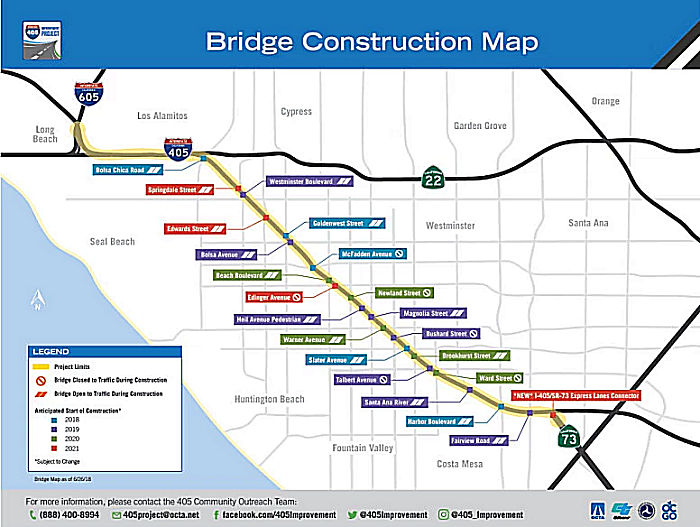 In August 2018, it was noted that construction has begun on the I-405 Improvement
project, and there was a staggered schedule for bridge closures. The first
of 18 bridges set for reconstruction is the McFadden Avenue bridge edging
Westminster and Huntington Beach. It will fully close at 10 p.m. Tuesday,
Aug. 7, 2018, remaining off-limits for at least a year. Over the following
two weeks, the bridge will undergo a two-part demolition, requiring total
freeway closures in both directions from 10 p.m. to 7 a.m.. Drivers will
be routed off the freeway at the ramp before McFadden Avenue and back on
at the next ramp. If driving northbound, that’s Beach Boulevard and
then Bolsa Avenue; vice-versa heading southbound. ther bridges with higher
traffic volumes will be handled in two stages rather than demolished all
at once, a process that will take about 18 months. In those cases, only
half of the bridge will be dismantled and traffic will be moved to the
remaining side. Eventually, traffic will shift to the completed side and
the second half of the bridge will be bulldozed and rebuilt. Next up on
the timeline after McFadden Avenue is the Slater Avenue bridge in Fountain
Valley, where construction should get underway by the end of 2018. Unlike
McFadden, it will remain in use, one side at a time. In addition to
McFadden, bridges scheduled to be wholly out of commission during
demolition and construction are Bushard Street and Talbert Avenue in 2019,
Newland Street and Ward Street in 2020 and Edinger Avenue in 2021. While
several bridges may be worked on simultaneously, no adjacent bridges will
be closed at the same time. Of the project’s $1.9 billion total
price tag, about $1.1 billion will come from Measure M, the county’s
half-cent sales tax for transportation improvements. The federal
government will cover $45.6 million, and the state $89.7 million. A
low-interest loan for $629 million will be paid off by revenue from
pay-to-use lanes. Ultimately, the end product will feature two new lanes
in each direction – increasing capacity from five to seven lanes.
The existing carpool lane on each side will become one of two
“express lanes” – still free for vehicles carrying three
or more people. Solo drivers will pay a fee for the lanes, as will cars
with two people during rush hour. Express lane users will need a
transponder that will automatically deduct fees. The price will range from
$10 at rush hour to 50 cents at nighttime.
In August 2018, it was noted that construction has begun on the I-405 Improvement
project, and there was a staggered schedule for bridge closures. The first
of 18 bridges set for reconstruction is the McFadden Avenue bridge edging
Westminster and Huntington Beach. It will fully close at 10 p.m. Tuesday,
Aug. 7, 2018, remaining off-limits for at least a year. Over the following
two weeks, the bridge will undergo a two-part demolition, requiring total
freeway closures in both directions from 10 p.m. to 7 a.m.. Drivers will
be routed off the freeway at the ramp before McFadden Avenue and back on
at the next ramp. If driving northbound, that’s Beach Boulevard and
then Bolsa Avenue; vice-versa heading southbound. ther bridges with higher
traffic volumes will be handled in two stages rather than demolished all
at once, a process that will take about 18 months. In those cases, only
half of the bridge will be dismantled and traffic will be moved to the
remaining side. Eventually, traffic will shift to the completed side and
the second half of the bridge will be bulldozed and rebuilt. Next up on
the timeline after McFadden Avenue is the Slater Avenue bridge in Fountain
Valley, where construction should get underway by the end of 2018. Unlike
McFadden, it will remain in use, one side at a time. In addition to
McFadden, bridges scheduled to be wholly out of commission during
demolition and construction are Bushard Street and Talbert Avenue in 2019,
Newland Street and Ward Street in 2020 and Edinger Avenue in 2021. While
several bridges may be worked on simultaneously, no adjacent bridges will
be closed at the same time. Of the project’s $1.9 billion total
price tag, about $1.1 billion will come from Measure M, the county’s
half-cent sales tax for transportation improvements. The federal
government will cover $45.6 million, and the state $89.7 million. A
low-interest loan for $629 million will be paid off by revenue from
pay-to-use lanes. Ultimately, the end product will feature two new lanes
in each direction – increasing capacity from five to seven lanes.
The existing carpool lane on each side will become one of two
“express lanes” – still free for vehicles carrying three
or more people. Solo drivers will pay a fee for the lanes, as will cars
with two people during rush hour. Express lane users will need a
transponder that will automatically deduct fees. The price will range from
$10 at rush hour to 50 cents at nighttime.
(Source: OC Register, 8/7/2018, updated 8/27/2018)
In January 2019, OCTA provided an update on the
project. It noted that major construction began in March 2018, when crews
began demolishing the McFadden Avenue, Slater Avenue, Bolsa Chica Road and
Magnolia Street bridges. 2019 was project to be a busy year for bridge
construction, with work planned on the Fairview Road and Bolsa Avenue
bridges followed by additional bridge construction later in the year. The
McFadden Avenue and Slater Avenue bridges are anticipated to be completed
and open to traffic in late 2019.
(Source: OCTA Blog, 1/18/2019)
In August 2019, it was reported that eleven months
after it closed to traffic, the rebuilt Slater Avenue bridge in Fountain
Valley was reopening. The overpass will be the first of 18 to reopen
during the massive expansion of the I-405. Ultimately, the 16-mile stretch
of I-405 between Route 73 in Costa Mesa and I-605 in Seal Beach will gain
two lanes in each direction. Mills said the entire project is on schedule
for completion in early 2023. When one bridge opens, another bridge closes
– or, in this case, two. On the same night that Slater reemerges,
the Bushard Street and Talbert Avenue overpasses – also in Fountain
Valley – will shut down for demolition and reconstruction. OCTA is
staggering the closures as a buffer to congestion and inconvenient
detours. With two-thirds of the bridges, Fountain Valley and Westminster
are the most impacted of the five Orange County cities bordering I-405. In
Summer 2018, McFadden Avenue, spanning Westminster and Huntington Beach,
became the first bridge to come down. Slater went second. The busiest
bridges are undergoing reconstruction in two phases. That way, they can
remain open one side at a time throughout – a slower approach that
adds about six months to the process. Slater and McFadden have both been
renovated in one stage. Yet Slater beat McFadden to the finish line
because it was one of the easier bridges, having no freeway on-ramp.
Still, it needed to be longer to accommodate the broadened freeway. Due to
simple geometry, it wound up about two feet higher, too. Slater is 15 feet
wider now, as well, allowing for more generous bike lanes and sidewalks on
each side. Another reason Slater moved along quickly was it did not
require water and sewer lines, as other bridges do.
(Source: OC Register $$$, 8/28/2019)
In March 2020, it was reported that crews shifted
traffic to the first reconstructed half of the new Magnolia Street bridge
on Monday, March 30. The Magnolia Street bridge, which straddles the
cities of Fountain Valley, Huntington Beach and Westminster, is being
demolished and reconstructed in two stages, one half at a time, allowing
it to remain open to traffic in both directions during construction. It is
one of 18 bridges to be built, widened or replaced as part of the I-405
Improvement Project, which will speed up travel times on I-405 between
Costa Mesa and the Los Angeles County line, an area traveled by more than
370,000 vehicles a day. The new portion of the Magnolia Street bridge will
be is the first to open among the project’s two-stage bridges. The
Slater Avenue bridge, which was fully demolished and reconstructed in one
stage, was the first reconstructed bridge to open to traffic in August.
(Source: OCTA Blog, 3/26/2020)
In June and July 2020, the OCTA reported that reduced
traffic volumes due to stay at home COVID-19 orders have accelerated
construction. Construction continues on the Bushard Street, Talbert Avenue
and McFadden Avenue overcrossings, which fully closed to traffic prior to
being demolished and rebuilt as part of the project. McFadden is expected
to open late in summer 2020, Bushard is anticipated to open late in 2020
and Talbert is scheduled for completion early 2021. Significant bridge
construction also continues at Fairview Road, Magnolia Street, Goldenwest
Street, Westminster Boulevard and Bolsa Chica Road. These bridges are
reconstructed one half at a time and are open to traffic during
construction. The first half of the Magnolia Street bridge was completed
in late March and construction on the second half began immediately after.
The first half of the other bridges are expected to open to traffic by the
end of 2020. Demolition of the second half of the Goldenwest Street bridge
is expected to occur in mid to late July 2020. Reconstruction of that
portion of the bridge is scheduled to take approximately one year to
complete. Unlike Bolsa Chica and Goldenwest, the Edwards Street bridge
will be demolished and reconstructed in one stage, so it will be fully
closed to traffic for approximately one year. Demolition of Edwards Street
is also planned for late July.
(Source: OCTA Blog, 6/15/2020; OCTA Blog, 7/8/2020)
In October 2020, it was reported that construction is
nearly 40 percent complete on the $1.9 billion I-405 Improvement Project.
Construction on the project began in 2018 and includes adding one regular
lane in each direction between Euclid Street and I-605, and a second lane
in each direction in the center of the freeway from Route 73 to I-605 that
will combine with the existing carpool lanes to form the 405 Express
Lanes. In addition, 18 bridges are being built, widened or replaced as
part of the project, which will speed up travel times on I-405 between
Costa Mesa and the Los Angeles County line. Significantly reduced traffic
volumes during the COVID-19 pandemic allowed OCTA and its partners to
implement extended overnight and daytime freeway lane closures to mitigate
schedule delays. The McFadden Avenue and Bushard Street bridges opened to
traffic at the end of October 2020, and the Talbert Avenue bridge is
expected to open in early 2021. The Edwards Street overcrossing was also
recently demolished and is under construction. Significant bridge
construction also continues at Fairview Road, Magnolia Street, Bolsa
Avenue, Goldenwest Street, Westminster Boulevard and Bolsa Chica Road.
These bridges are being rebuilt one half at a time so they can remain open
to traffic. The first halves of the new Magnolia Street, Goldenwest Street
and Bolsa Chica Road overcrossings opened in early 2020, and the first
halves of the new Fairview Road, Bolsa Avenue and Westminster Boulevard
overcrossings are anticipated to open in Spring 2021. Construction on the
project is anticipated to be completed in 2023.
(Source: OCTA Blog, 10/7/2020)
In February 2021, it was reported that construction is
50 percent complete. The first half of the new Westminster Boulevard
bridge opened to traffic in Westminster on January 28, and the first half
of the Fairview Road bridge in Costa Friday opened on February 12.
The two bridges are among 18 to be built, widened or replaced as part of
the project, which aims to speed up travel times on I-405 between Costa
Mesa and the Los Angeles County line. Both bridges are being demolished
and reconstructed in two stages, one half at a time, allowing them to
remain open to traffic in both directions during construction. Demolition
of the second half of the Westminster Boulevard bridge was planned for
early February 2021, and demolition of the second half of the Fairview
Road bridge was planned for late February. The Talbert Avenue and
Magnolia Street bridges, along with the first half of the Bolsa Avenue
bridge, are expected to open in the first half of 2021. Later in the year,
the Heil Avenue pedestrian overcrossing, along with the Edwards Street,
Bolsa Chica Road and Goldenwest Street bridges, are scheduled to open.
(Source: OCTA Blog, 2/5/2021, OCTA Blog, 2/19/2021)
In July 2023, it was reported that the $2.1 billion
project to improve I-405 in Orange County is almost finished, and should
completed by the end of 2023. The project adds one general lane in each
direction between Costa Mesa and the Orange County and Los Angeles County
line. It also creates a second lane that combines with the existing
carpool lane to create the 405 Express Lanes. The average toll is $3 for
going northbound, southbound, anytime of the day or night. There are also
different segments so drivers can get in and out of the express lanes of
the carpool lanes at various points. There will be no tolls for carpools
with three or more people, motorcycles or vehicles with designated
veterans license plates, or disabled person license plates. Clean air
vehicles will have a 15% discount. Carpools with two people can use the
lanes without paying in the first three and a half years during non-peak
hours, which are outside the hours of 6 to 10 a.m. and 2 to 7 p.m. Monday
through Friday and outside of 1 to 7 p.m. Saturday and Sunday. Solo
drivers and two-person carpools would always have to pay a toll during
peak hours. Tolls would depend on the day of the week, hour, direction of
travel and distance traveled. The maximum toll rate for the entire drive
is $9.95 and the minimum is $2.70. Drivers will be required to have
transponders in order to use the express lanes. Toll rates will be
reviewed and adjusted on a quarterly basis. The money will go toward
paying the $629-million federal loan that the OCTA received to construct
the express lanes.
(Source: ABC 7, 7/13/2023; Los Angeles Times, 7/14/2023)
In October 2023, it was reported that the I-405
Improvement Project is expected to be completed on 12/1/2023, and with it,
two new regular lanes and new Express Lanes will open in Orange County.
Each side of the freeway between I-605 Freeway in Seal Beach and Euclid
Street in Fountain Valley will have a new regular lane. Additionally,
Express Lanes will be opened between I-605 and Route 73 in Orange County.
Those lanes are tolled for solo drivers, free for vehicles with two
occupants during non-peak hours, and always toll-free for vehicles with
three or more occupants, motorcyclists and those with veteran and disabled
license plates. Vehicles will need to have a FasTrak transponder and a
valid account with any toll agency in California to enter these lanes and
take advantage of the service.
(Source: KTLA, 10/23/2023)
In December 2023, it was reported that the new express
lanes on the I-405 in Orange County have opened. The lanes, which span 16
miles from I-605 Freeway at the Los Angeles County line to Route 73 in
Costa Mesa, use electronic tolling, requiring drivers to have a FasTrak
transponder. The actual cost to drivers will fluctuate based on the time
of day, the day of the week and the direction of travel. The lanes can be
accessed for free by some carpoolers, but a transponder is always
required.
(Source: KTLA, 12/1/2023)
![[Susan St.]](maps/405-susanst.jpg) In April 2007, the CTC considered approval of a Negative
Environmental Impact Statement and approval of a public road connection
for the Susan Street Ramp (~ ORA 11.524). This project would construct a
northbound exit ramp about 0.4 miles N of the Route 73 merge ramp onto
I-405. The proposed exit ramp would connect to the southern extension
Susan Street at the IKEA driveway intersection. The exit ramp is estimated
to cost $1.5 million and is fully funded from local sources. Construction
would begin in FY 2007-08. The proposed improvement will mitigate
congestion by providing direct access from the northbound I-405
distributor road and diverting traffic from the existing Harbor Boulevard
and Fairview Road interchanges to this proposed improvement at Susan
Street. The proposed improvement is to construct a northbound I-405
off-ramp to Susan Street. Susan Street, a north-south arterial, is located
north of I-405 midway between Harbor Boulevard and Fairview Road. The
Susan Street off-ramp will begin 0.4 miles west of northbound Route 73 to
northbound I-405 merge. The off-ramp extends 0.2 miles as a single lane
and widens to three lanes at the ramp terminus. The Susan Street off-ramp
will be braided below the Fairview Road on-ramp to northbound I-405. The
proposed improvements will increase the capacity and improve operations of
the existing Harbor Boulevard and Fairview Road interchanges.
In April 2007, the CTC considered approval of a Negative
Environmental Impact Statement and approval of a public road connection
for the Susan Street Ramp (~ ORA 11.524). This project would construct a
northbound exit ramp about 0.4 miles N of the Route 73 merge ramp onto
I-405. The proposed exit ramp would connect to the southern extension
Susan Street at the IKEA driveway intersection. The exit ramp is estimated
to cost $1.5 million and is fully funded from local sources. Construction
would begin in FY 2007-08. The proposed improvement will mitigate
congestion by providing direct access from the northbound I-405
distributor road and diverting traffic from the existing Harbor Boulevard
and Fairview Road interchanges to this proposed improvement at Susan
Street. The proposed improvement is to construct a northbound I-405
off-ramp to Susan Street. Susan Street, a north-south arterial, is located
north of I-405 midway between Harbor Boulevard and Fairview Road. The
Susan Street off-ramp will begin 0.4 miles west of northbound Route 73 to
northbound I-405 merge. The off-ramp extends 0.2 miles as a single lane
and widens to three lanes at the ramp terminus. The Susan Street off-ramp
will be braided below the Fairview Road on-ramp to northbound I-405. The
proposed improvements will increase the capacity and improve operations of
the existing Harbor Boulevard and Fairview Road interchanges.
In August 2015, the CTC authorized $82,000,000 for a project in Orange County on I-405 in Fountain Valley, from Ellis Ave/ Euclid Avenue to Magnolia Street (~ ORA 12.433 to ORA 15.224) that would construct auxiliary lanes in each direction as part of the larger I-405 Widening project EA 0H100. This project is necessary to reduce congestion and improve highway operations and mobility.
The SAFETEA-LU act, enacted in August 2005 as the reauthorization of TEA-21, provided the following expenditures for this route:
Route 405/Route 22 Connectors (~ ORA 20.459 to ORA 23.496)
 At its meeting on July 9, 2009, the CTC approved a CMIA project baseline agreement amendment to
split the Route 22/405/605 HOV Connector with ITS Elements project (PPNO
2868C) into two construction projects: (1) Route 22 to I-405 between Seal
Beach Boulevard and Valley View Street (PPNO 2868B); (2) I-405 to Route 605 between Katella Avenue and Seal Beach Boulevard (PPNO 2868C). In
October 2009, the funding was rearranged to give some priority to the
first of these two. In February 2010, the CTC approved amending the CMIA
Program project baseline agreement for the Route 22/405/605 HOV Connector
project (PPNO 2868C) to transfer $3,360,000 from CMIA reserve to
Construction and reduce Congestion Mitigation and Air Quality Program
(CMAQ) funding by $24,100,000.
At its meeting on July 9, 2009, the CTC approved a CMIA project baseline agreement amendment to
split the Route 22/405/605 HOV Connector with ITS Elements project (PPNO
2868C) into two construction projects: (1) Route 22 to I-405 between Seal
Beach Boulevard and Valley View Street (PPNO 2868B); (2) I-405 to Route 605 between Katella Avenue and Seal Beach Boulevard (PPNO 2868C). In
October 2009, the funding was rearranged to give some priority to the
first of these two. In February 2010, the CTC approved amending the CMIA
Program project baseline agreement for the Route 22/405/605 HOV Connector
project (PPNO 2868C) to transfer $3,360,000 from CMIA reserve to
Construction and reduce Congestion Mitigation and Air Quality Program
(CMAQ) funding by $24,100,000.
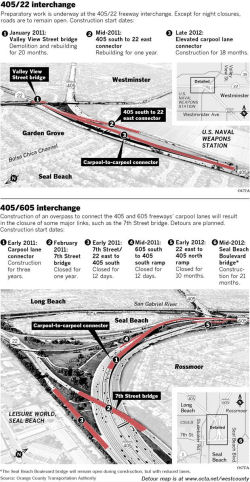
In September 2012, construction crews will shut down the eastbound Route 22 connector to the northbound I-405 for one year. The transition road, which carries about 3,000 vehicles a day must be rebuilt to make way for the new carpool lane connector between I-405 and I-605. During construction, the eastbound Route 22 transition to the northbound I-605 will remain open. From eastbound Route 22, the Orange County Transportation Authority advises motorists to exit and turn right at Studebaker Road and continue north to access the northbound I-405 on-ramp. All of the construction is part of a project that will connect carpool lanes on I-405, I-605 and Route 22. It's scheduled for completion in 2014.In December 2010, it was reported that construction was beginning, and commuters will be hit hard. The $277-million freeway project requires a series of road closures, including one of the main portals to a veterans' hospital and a major state university. The work will be done in two segments, and lane and street closures are to be sequenced to minimize some of the traffic impacts. When completed in 2014, the so-called West County Connector project built by the Orange County Transportation Authority will create a seamless link between carpool lanes and ease rush-hour bottlenecks on the I-405, Route 22 and I-605 freeways. The project calls for an additional carpool lane in each direction of the I-405 between Route 22 and I-605. Large overpasses will be built to connect the carpool lanes on the I-405 to those on the other freeways. Bridges and connectors throughout the project area are to be rebuilt, including those at 7th Street, Valley View Street and Seal Beach Boulevard. Onramps and offramps related to those structures also will be redone. In addition to 7th Street, two other heavily traveled bridges will be affected by the project: Seal Beach Boulevard over the I-405 and Valley View Street over Route 22. The number of traffic lanes will be reduced on the bridges for 11 months and 20 months, respectively.
I-405 Expansion in Orange County - Long Beach Reaction (LA 0.000 to LA 2.265)
The LA Times reported in 2009 on a dichotomy between
Los Angeles and Orange County regarding I-405 widening. Although Orange
County has plans to add up to two lanes on each side of the roughly
14-mile stretch of I-405 between Route 73 and I-605. Bridges would also be
rebuilt, some homes would be taken under eminent domain and the carpool
buffer would shrink. However, Los Angeles county has no plans for
widening. One reason is that the L.A. County side has less space for
expansion than Orange County does. Los Angeles county has focused more
energy and funds towards rail lines. This may create a problem similar to
that seen on I-5 at the county line.
(Source: Los Angeles Times, 11/17/2009)
In July 2013, it was reported that Long Beach has protested the expansion plans in the original study. The revised study presents three alternatives, in addition to the required no build alternative:
According to the supplemental study, between two to five intersections (not including ramps) in Long Beach would be impacted if one of the improvements is built. That number rises to four to nine intersections by 2040. The intersections immediately impacted by all three alternatives are at Los Coyotes Diagonal (~ LA 2.265) and Bellflower Boulevard and Willow Street and Bellflower Boulevard. If one of the larger alternatives is chosen, impacts are expected at Willow Street and Woodruff Avenue and Willow Street and Los Coyotes Diagonal. Percentages of intersection improvement costs paid for by Caltrans and OCTA in the draft report range from 30% to 4.45%, with each intersection costing between $240,000 to $810,000.
In August 2013, the CTC received a draft EIR for comment. The project in Los Angeles and Orange Counties proposes to construct roadway improvements on Interstate 405 (I-405) within the project limits, including 15 local street interchanges and three freeway-to-freeway interchanges (12-Ora-405, PM 9.3/24.2, 07-LA-405, PM 0.0/1.2, 12-Ora-22, PM R0.7/R3.8, 12-Ora-22, PM R0.5/R0.7, 12-Ora-73, PM R27.2/R27.8, 12-Ora-605, PM 3.5/R1.6 07-LA-605, PM R0.0/R1.2). The project is not fully funded. Depending on the alternative selected, the total estimated project cost ranges between $1.3 billion and $1.7 billion. The project will seek funding through the State Transportation Improvement Program, federal and local fund sources, and possibly toll revenue. Depending on the availability of funding, construction is estimated to begin in Fiscal Year 2015-16. Alternatives considered for the proposed project include:
According to the August 2013 revised study, the following measures would be incorporated to minimize impacts of the project:
In July 2015, it was reported that Long Beach is suing
Caltrans and the Orange County Transportation Authority over the $1.7
billion project to expand I-405. The City Council authorized the city
attorney in closed session Tuesday to file the lawsuit challenging the
environmental documents filed with the plan, which widens I-405 by four
lanes through Orange County to just past the Long Beach border. The city
is seeking additional measures to reduce the impact of increased traffic
on local streets. The environmental impact report for the I-405 expansion
lists five intersection that will see improvements in Long Beach related
to the widening plans, but assigns about 7-25 percent of the cost for the
upgrades to OCTA. The rest is expected to be picked up by the city.
(Source: LB Press Telegraph 7/14/2015)
In April 2017, it was reported that completion of the upgrade of the
Wilmington Interchange (~ LA 9.553) was delayed. Expansion of the
often-clogged interchange was supposed to finish early in 2016, but now
completion isn’t expected until 2018. Not only is the project two
years behind schedule, it will cost $8 million more than expected because
of delays and unanticipated underground utilities that got in the way.
This widening project was conceived in 2005 to open up the intersection
and freeway ramps so vehicles could more quickly move through. Work is
being done in five stages, with the third stage now nearly complete. A
newly built northbound I-405 on-ramp is nearly ready to open, and much of
the work on the dam and bridge over the Dominguez Channel is done. Next,
the bridge will be repaved. Wilmington Avenue also is being widened
between East 223rd Street and East 220th Street, and new pavement and
other upgrades are being added to the intersection and southbound ramp.
The project’s two-year delay is largely because Southern California
Edison was extremely slow to respond to work requests needed before
construction stages could begin. The company thought Edison would take
months to do work that it took years to do, said officials. Also, numerous
underground oil pipelines and utility lines, ducts and vaults were
encountered that weren’t anticipated in design plans. The
Metropolitan Transportation Authority and Federal Highway Administration
financed much of the total $27 million cost. But bond funds were also used
from Carson’s Successor Agency, the city’s former
redevelopment arm.
(Source: Daily Breeze, 4/22/2017)
Avalon Interchange Improvements (~ LA 11.24)
The SAFETEA-LU act, enacted in August 2005 as the reauthorization of TEA-21, provided the following expenditures for this route:
In October 2011, the CTC approved for future consideration of funding a project in Los Angeles County that will improve the Avalon Boulevard/I-405 interchange by constructing a new southbound on-ramp, widening the northbound off-ramp and on-ramp, and widening northbound Avalon Boulevard. The project is fully funded with Local and Federal funds. This project will be requesting a New Public Road Connection from the California Transportation Commission at the October 26-27, 2011 Meeting. The total estimated cost is $19,300,000. Construction is estimated to begin in Fiscal Year 2010-11. A copy of the ND has been provided to Commission staff. Due to potential impacts to visual resources, hydrology and water quality, community impacts, cultural resources, and the local economy, an Initial Study was completed for the project. Based upon environmental studies and proposed environmental commitments, including minimization and avoidance measures, incorporation of BMPs, limited hours of construction, the project will not have a significant effect on the environment. As a result, an ND was completed for this project.
The proposed new route connnection will be at Lenardo Drive. The specific proposal is to modify the Avalon Boulevard/I-405 interchange in the city of Carson to provide access to the approved development of the Carson Marketplace Project in the southwest quadrant of this interchange. The modifications to this interchange include the southerly extension of Lenardo Drive over the Torrance Lateral Channel to connect to Avalon Boulevard and the realignment of the southbound I-405 on and off ramps to begin and end at Lenardo Drive. This break in access control requires the approval of a new connection by the California Transportation Commission. The proposed improvements support the additional access needs of the Carson Marketplace Project and also address growing traffic volumes in the vicinity. The Avalon Boulevard interchange is located in the city of Carson, in Los Angeles County, between the Main Street and the Carson Street interchanges along I-405. I-405 has 12 lanes north of Avalon Boulevard and 10 lanes south of Avalon Boulevard. Traffic in the southbound direction is served by a loop on-ramp and a diagonal off-ramp in the southwest quadrant of the interchange. In the northbound direction the interchange is a half diamond. Avalon Boulevard is a major thoroughfare through the City of Carson with four to six lanes serving primarily residential, commercial, and light industrial traffic demands. The proposed interchange modification would extend the existing Lenardo Drive south from the proposed Carson Marketplace over the Torrance Lateral Channel to Avalon Boulevard. The existing southbound I-405 on- and off-ramps, located between the Torrance Lateral Channel and Avalon Boulevard, will be realigned and widened. A new two-lane southbound on-ramp will be constructed east of Avalon Boulevard and across from Lenardo Drive. The existing northbound off-ramp will be widened from one to three lanes at the terminus to increase storage capacity and to accommodate left turns. The northbound on-ramp will also be widened to increase capacity and accommodate two left-turn lanes from northbound Avalon Boulevard. The existing Avalon Boulevard structure will be widened and repaved.
In March 2016, the CTC approved additional funding for a project on Route 405 in Los Angeles County from LA 12.6 to LA 21.2 (essentially, from I-110 to I-105) that will install concrete barrier and metal beam guardrail along the project limits.
Route 110 / Route 405 Interchange Improvement (~ LA 12.875 to LA 13.013)
In March 2016, the Los Angeles MTA presented its full
proposal for what transit lines could be built -- and when -- if Los
Angeles County voters approve a half-cent sales tax increase in November
2016. This proposal included funding for the I-110 Express Lane Ext South
to I-405/I-110 Interchange. The new project would extend the existing
I-110 Express Lanes southward to the I-405, for a total of 1 mile. This
will create a total of 5 Mixed-Flow lanes and 1 Express Lane for that
mile. Additionally, the proposal included funding for direct connector
ramps between the I-110 and I-405 express lanes. (~ LA 12.875)
(Source: Los Angeles Times 3/18/2016; Metro Board Report 3/24/2016)
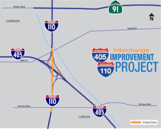 In May 2018, it was reported that ground was broken for the 405/110
interchange project (~ LA 13.013). The $35-million I-110/I-405 interchange
improvement project will widen the northbound San Diego Freeway connector
to the southbound Harbor Freeway. A new auxiliary lane will also be
constructed from the I-110/I-405 interchange to Del Amo Boulevard.
Construction is anticipated to be completed in 2021. Metro provided seed
funding for the project’s initial environmental work through its
Measure R transportation sales tax that was approved by voters in 2008.
The SB1 "gas tax" allowed the improvement project to be fast-tracked.
Another $1.2 million of environmental work enabled the SBCCOG and Metro to
have the project shovel-ready when the funding became available last fall.
In May 2018, it was reported that ground was broken for the 405/110
interchange project (~ LA 13.013). The $35-million I-110/I-405 interchange
improvement project will widen the northbound San Diego Freeway connector
to the southbound Harbor Freeway. A new auxiliary lane will also be
constructed from the I-110/I-405 interchange to Del Amo Boulevard.
Construction is anticipated to be completed in 2021. Metro provided seed
funding for the project’s initial environmental work through its
Measure R transportation sales tax that was approved by voters in 2008.
The SB1 "gas tax" allowed the improvement project to be fast-tracked.
Another $1.2 million of environmental work enabled the SBCCOG and Metro to
have the project shovel-ready when the funding became available last fall.
(Source: Metro "The Source", 6/1/2018; DailyBreeze
6/1/2018, from which the graphic was snarfed)
In June 2020, it was reported that the northbound I-405
freeway connector to the southbound I-110 freeway in Carson would close
over the weekend for a $50 million road widening and realignment project.
The project will add a new lane between the on and off-ramps from the
I-405/I-110 interchange to Del Amo Boulevard, increasing the capacity of
the connector, in an attempt to improve traffic flow and reduce backups.
After the closure, traffic will be on the new configuration for the
connector. The article noted that work is 90% done, and the project is
tentatively scheduled to complete by the end of October 2020.
(Source: Daily Breeze, 6/26/2020)
In Fall 2022, LA Metro included, as a potential project in its "I-405
Comprehensive Multimodal Corridor Plan", a proposed project that
will construct ExpressLanes from I-110 to I-105. The project was ranked in
tier 2B.
(Source: Los Angeles Metro, "I-405 Comprehensive Multimodal Corridor Plan", Fall 2022, Appendix E: CMCP Projects List)
In March 2016, the Los Angeles MTA presented its full proposal for what
transit lines could be built -- and when -- if Los Angeles County voters
approve a half-cent sales tax increase in November 2016. This proposal
included funding for I-405 South Bay Curve Improvements. The project will
add segments of an Auxiliary Lane in each direction to address existing
bottleneck and to improve the weaving movements at on/off ramps, from
I-110 to Florence Ave. for a total of 10.4 miles, while maintaining the
current existing facility consisting of 4 Mixed-Flow lanes and 1 HOV lanes
in each direction. (~ LA 13.118 to LA 23.503)
(Source: Los Angeles Times 3/18/2016; Metro Board Report 3/24/2016)
Crenshaw Interchange (~ LA 15.451)
In June 2015, it was reported that Caltrans was seeking
public reaction to an environmental analysis prepared for the pending
reconstruction of the chronically congested Crenshaw Boulevard and 182nd
Street interchange with I-405 that’s scheduled to start in July
2018. The complex, four-year-long project is expected to cost $60.5
million to $85.2 million for its design and construction depending on
which of three alternatives is selected. The entire interchange is
persistently overloaded, a situation that worsens considerably during rush
hour. Short on- and off-ramps create potentially dangerous lines of
vehicles on surface streets and on the freeway itself, hampering the
efficiency of I-405. Improvements to be made include: (•) Adding an
additional lane to the existing freeway on‐ and off- ramps and
constructing a new two-lane on‐ramp to the SB I-405 from Crenshaw
Boulevard; (•) Widening Crenshaw Boulevard south of the interchange
to make room for a new, exclusive right-turn lane onto the proposed new
southbound on-ramp; (•) Widening westbound 182nd Street between the
NB I-405 on- and off-ramps and Crenshaw Boulevard; and (•) Building
or reconstructing more than more than 12,000 feet of sound walls.
(Source: Daily Breeze, 6/24/2015)
In October 2016, the CTC approved for future consideration of funding a project in Los Angeles County that will widen I-405, including the existing on- and off-ramps on Crenshaw Boulevard, and construct a new southbound on-ramp from Crenshaw Boulevard. The project is not fully funded. The project is fully funded for the environmental phase only with local funds. The total estimated cost is $87,100,000 for capital and support. Depending on the availability of funding, construction is estimated to begin in Fiscal Year 2020.
The 2018 STIP, approved at the CTC March 2018 meeting, appears to allocate $12,000K for PPNO 4410, Crenshaw Blvd Interchange Improvements. This would be construction support in FY22-23, meaning the project is delayed.
In March 2020, the CTC approved the 2020 STIP, which
appears to move the programmed funding for PPNO 4451 "Rt 405/Crenshaw
Blvd, ramp improvement" from FY22-23 to FY20-21.
(Source: March 2020 CTC Agenda, Item 4.7, 2020 STIP
Adopted 3/25/2020)
In December 2020, the CTC approved the following
allocation for State Administered STIP Projects on the State Highway
System: $12,000,000 for Con Eng for 07-LA-405 PM 14.3/15.8. PPNO 07-4451
ProjID 0713000238 EA 29360. I-405 at Crenshaw Boulevard Ramp Improvement.
In Los Angeles County, in the city of Torrance, between Western Avenue and
West 182nd Street/Crenshaw Boulevard. Add a new I-405 on-ramp at Crenshaw
Boulevard, increase storage capacity on the existing on/off ramps and add
auxiliary lanes on the I-405 on both directions. (CEQA - ND, 06/29/2016;
Re-validation 05/12/2020) (NEPA - FONSI, 06/29/2016; Re-validation
05/12/2020) (Right of Way Certification: 09/11/2020) (Future consideration
of funding approved under Resolution E-16-72; October 2016.)
(Source: December 2020 CTC Agenda, Agenda Item
2.5c.(1) #2)
The SAFETEA-LU act, enacted in August 2005 as the reauthorization of TEA-21, provided the following expenditures for this route:
In Fall 2022, LA Metro included, as a potential project in its "I-405
Comprehensive Multimodal Corridor Plan", a proposed project that
will construct ExpressLanes from I-105 to I-10. The project was ranked in
tier 2B.
(Source: Los Angeles Metro, "I-405 Comprehensive Multimodal Corridor Plan", Fall 2022, Appendix E: CMCP Projects List)
In Fall 2022, LA Metro included, as a potential project in its "I-405
Comprehensive Multimodal Corridor Plan", a proposed project that
will construct HOV connectors from I-105 WB to NB and SB I-405. The
project was ranked in tier 3.
(Source: Los Angeles Metro, "I-405 Comprehensive Multimodal Corridor Plan", Fall 2022, Appendix E: CMCP Projects List)
In August 2015, the CTC authorized $14,130,000 for a project in Los Angeles County, on I-405 in and near the cities of Inglewood, Culver City, and Los Angeles, from 0.2 mile north of El Segundo Boulevard to Venice Boulevard (Route 187) (~ LA 20.413 to LA 27.983) that will rehabilitate 56 lane miles of pavement by replacing cracked slabs, grinding concrete pavement, overlaying ramp and shoulder asphalt pavement, installing new guardrail, and paving miscellaneous areas. This project is necessary to extend pavement service life and improve ride quality.
![[Arbor-Vitae Map]](maps/405-arbor.jpg) There are continual discussions about adding an
interchange at Arbor-Vitae (~ LA 22.759). Based on an article in the Daily
Breeze, the plan is based on a much earlier plan to construct a new
interchange along I-405 at Arbor Vitae Street. The project was original
initiated by Los Angeles World Airports (Los Angeles Department of
Airports at the time) in 1976 to provide an alternate East-West access
route between I-405 and the Los Angeles International Airport. This
project was part of a larger project proposed in 1980 and scheduled to be
constructed in 1984. However, the Arbor Vitae Interchange had been
postponed multiple times due to funding considerations. The current
version of the project entailing the south half of the interchange and
widening of the Arbor Vitae Bridge was going to be constructed in 2002.
However, the delivery of this project was postponed for three reasons:
First, opposition from local residents, who live adjacent to the proposed
project, and the Inglewood Unified School District Board was prevalent
during the public comment periods; second, the Southern California
Association of Governments (SCAG) did not support the construction of the
full interchange, and led to the current south half version of the
interchange. Third, the Federal Highway Administration (FHWA) would only
approve an environmental document that includes the full interchange. It
lacks support from local elected officials. At this time, this project is
programmed through the Project Approval/Environmental Document [PA/ED]
phase (the current phase). There is only partial funding currently
programmed for the construction of this proposed project; an additional
$37 million is needed to construct this project. If approved, the project
will be funded from the State Transportation Improvement Program (STIP)
and the Regional Transportation Improvement Program (RTIP). The proposal
called for a new south-half interchange, including a southbound on-ramp to
I-405 from a widened Arbor Vitae overpass, as well as a northbound
off-ramp from the freeway to the street. The project’s purpose is to
reduce congestion at the Century Boulevard and Manchester Boulevard
interchanges by creating along Arbor Vitae Street, from the I-405, a new
direct vehicle access to and from the Hollywood Park Casino, the
University of West Los Angeles, the Forum, and Centinela Hospital. The
project would result in the agency taking nine homes and two businesses -
down from roughly 50 homes under an earlier plan, which also encroached on
an Inglewood school site, according to planning documents. A later meeting
indicated a fair amount of opposition to the plan. In September 2010, it
was reported that Caltrans had cancelled plans for this interchange.
Specifically, Caltrans chose the "no-build" alternative - which was based
on several factors, including the project's anticipated effects on traffic
conditions along local streets, community opposition as well as funding.
The agency needed roughly another $30 million to fund the estimated $82
million project. Additionally, a Caltrans letter stated that the Federal
Highway Administration failed to grant the exception needed to build the
proposed half-interchange.
There are continual discussions about adding an
interchange at Arbor-Vitae (~ LA 22.759). Based on an article in the Daily
Breeze, the plan is based on a much earlier plan to construct a new
interchange along I-405 at Arbor Vitae Street. The project was original
initiated by Los Angeles World Airports (Los Angeles Department of
Airports at the time) in 1976 to provide an alternate East-West access
route between I-405 and the Los Angeles International Airport. This
project was part of a larger project proposed in 1980 and scheduled to be
constructed in 1984. However, the Arbor Vitae Interchange had been
postponed multiple times due to funding considerations. The current
version of the project entailing the south half of the interchange and
widening of the Arbor Vitae Bridge was going to be constructed in 2002.
However, the delivery of this project was postponed for three reasons:
First, opposition from local residents, who live adjacent to the proposed
project, and the Inglewood Unified School District Board was prevalent
during the public comment periods; second, the Southern California
Association of Governments (SCAG) did not support the construction of the
full interchange, and led to the current south half version of the
interchange. Third, the Federal Highway Administration (FHWA) would only
approve an environmental document that includes the full interchange. It
lacks support from local elected officials. At this time, this project is
programmed through the Project Approval/Environmental Document [PA/ED]
phase (the current phase). There is only partial funding currently
programmed for the construction of this proposed project; an additional
$37 million is needed to construct this project. If approved, the project
will be funded from the State Transportation Improvement Program (STIP)
and the Regional Transportation Improvement Program (RTIP). The proposal
called for a new south-half interchange, including a southbound on-ramp to
I-405 from a widened Arbor Vitae overpass, as well as a northbound
off-ramp from the freeway to the street. The project’s purpose is to
reduce congestion at the Century Boulevard and Manchester Boulevard
interchanges by creating along Arbor Vitae Street, from the I-405, a new
direct vehicle access to and from the Hollywood Park Casino, the
University of West Los Angeles, the Forum, and Centinela Hospital. The
project would result in the agency taking nine homes and two businesses -
down from roughly 50 homes under an earlier plan, which also encroached on
an Inglewood school site, according to planning documents. A later meeting
indicated a fair amount of opposition to the plan. In September 2010, it
was reported that Caltrans had cancelled plans for this interchange.
Specifically, Caltrans chose the "no-build" alternative - which was based
on several factors, including the project's anticipated effects on traffic
conditions along local streets, community opposition as well as funding.
The agency needed roughly another $30 million to fund the estimated $82
million project. Additionally, a Caltrans letter stated that the Federal
Highway Administration failed to grant the exception needed to build the
proposed half-interchange.
In Fall 2022, LA Metro included, as a potential project in its "I-405
Comprehensive Multimodal Corridor Plan", a proposed project that
will realign the SB I-405 from Manchester where it bends sharply just N of
Manchester. The project was ranked in tier 3.
(Source: Los Angeles Metro, "I-405 Comprehensive Multimodal Corridor Plan", Fall 2022, Appendix E: CMCP Projects List)
In October 2014, the CTC authorized additional funding for the project in Culver City, from La Tijera Boulevard on-ramp to Jefferson Boulevard off-ramp (~ LA 24.282 to LA 25.752), that will construct an auxiliary lane to improve traffic flow and reduce congestion. The project widens and seismically retrofits the Centinela Avenue Undercrossing (No. 53-1253) and the Sepulveda Boulevard Undercrossing (No. 53-1254 ). The Howard Hughes Parkway on-ramp and the Sepulveda Boulevard off-ramp will also be realigned and widened as part of the project. The project also constructs retaining walls to accommodate the widened roadway. The project relieves congestion by improving traffic operations.
In 2008-2009, Caltrans widened I-405 from ten to twelve lanes from Route 90 to I-10 (~ LA 25.72 to LA 29.429). This project added one HOV lane
northbound. It resulted in signficant changes in the Culver Blvd offramp.
The the previous NB exit that deposited Culver traffic at Braddock and
Sawtelle was removed; it was replaced by a direct offramp at Culver. A
similar change was made for southbound traffic. The lanes were opened in
November 2009. The $167 million widening project took five years to
complete, and added carpool lanes and exit lanes on the freeway. The five
main traffic lanes in each direction were widened from 10 feet wide to 12
feet, and the often-uneven asphalt surface next to the center divider was
replaced with concrete.
(Source: KCBS 11/7/2009)
In December 2013, the CTC authorized relinquishment of right of way in the city of Culver City adjacent to Route 405 between Sawtelle Boulevard and Barman Avenue, consisting of a reconstructed city street (~ LA 27.046).
In 1989, the CTC relinquished roadway that predated Route 405 (i.e., former Route 7): Sepulveda Blvd between I-405 and Slauson. (~ LA 26.029)
The SAFETEA-LU act, enacted in August 2005 as the reauthorization of TEA-21, provided the following expenditures for this route: (~ LA 29.429 to LA 39.183)
I-10 to Waterford HOV Lanes (~ LA 29.677 to LA 32.126)
In 2008, a project was completed that widened the freeway and added southbound HOV lanes between Waterford St and 0.5 km S of I-10. This section of the freeway was origianlly constructed on a fill segment between 1958 and 1963. It was an eight-lane facility consisting of four 12 ft lanes, with 8-10 ft shoulders and a 22 ft median. Later restriping reduced this to a non-standard 11 ft lanes, with the median being used to add two mixed flow lanes and a 4 ft non-standard half-median. The project widened the existing freeway to add an 11.8 ft HOV lane, and a 2 ft buffer next to the median. The five existing mixed flow lanes were restriped even narrower as four 10.8 ft lanes and one 11.8 ft lane. A 9.8 ft outside shoulder, and a 3.3 ft half median was also provided. To eliminate weaving conditions, two auxiliary lanes were added. One was added upstream of the SB off-ramp to WB Wilshire Blvd, and included widening of the off-ramp. The second was added between the SB I-405 on-ramp from Santa Monica Blvd and the SB I-405 off-ramp at Olympic Blvd. The current auxiliary lane between Santa Monica Blvd and Wilshire Blvd was maintained. Additionally, the Waterford Street on-ramp SB was closed. The total cost for this project is $74.4 million, with an estimated completion of August 2006 (although this date was not met). This is TCRP Project 52. It was completed around 2008.
In June 2017, the CTC was informed that, for TCRP Project 52 - Route 405; HOV and Auxiliary Lanes – Waterford Avenue to Route 10 (PPNO T0520), the authorized amount was $25,000,000, of which $9,648,000 was previously programmed and allocated to the project. Due to the suspension of TCRP funding in 2003, this project was delivered with other State funds, leaving $15,352,000 in unallocated TCRP funds on the project. In June 2016, the Commission approved a TCRP policy for projects programmed in Tier 2 and in January 2017, funding for Tier 2 programmed projects became available. TCRP 52 is currently on the Tier 2 list for $15,352,000. The Department and Metro propose to amend Project 52 to de-program $15,352,000 in TCRP savings and update the project funding plan and transfer the funds to fund TCRP Project 38.2, Los Angeles -San Fernando Valley Transit Extension and TCRP 50, Route 71.
LA Metro Improvements - HOT/Tunnel, West LA to San Fernando Valley
In March 2016, the Los Angeles MTA presented its full
proposal for what transit lines could be built -- and when -- if Los
Angeles County voters approve a half-cent sales tax increase in November
2016. This proposal included funding for some form of Sepulveda Pass
Transit Corridor. The specific approach was not specified: it could be a
new high capacity transit mode connecting the Orange Line Van Nuys station
underneath the Sepulveda Pass, with a station at UCLA, terminating at
Wilshire/Westwood Purple Line station. Approximately 8.8 miles. The
project might also include restriping the HOV lanes within the existing
Right of Way to add 2 ExpressLanes in each direction (while maintaining
the current 4 Mixed-Flow Lanes), from US-101 to I-10 for a total of 10
miles. There have also been rumors of a private vehicle toll tunnel under
the Sepulveda Pass.
(Source: Los Angeles Times 3/18/2016; Metro Board Report 3/24/2016)
In March 2016, the Los Angeles MTA presented its full
proposal for what transit lines could be built -- and when -- if Los
Angeles County voters approve a half-cent sales tax increase in November
2016. This proposal included funding for I-105 Express Lanes from I-405 to
I-605. The project would re-stripe the existing HOV lane to create 2
Express Lanes in each direction for a total of 16 miles, while maintaining
current number of mixed flow lanes in each direction.
(Source: Los Angeles Times 3/18/2016; Metro Board Report 3/24/2016)
In Fall 2022, LA Metro included, as a potential project
in its "I-405 Comprehensive Multimodal Corridor Plan", a proposed
project that will convert the HOV lanes from I-10 to US 101 into
ExpressLanes. The project was ranked in tier 3.
(Source: Los Angeles Metro, "I-405 Comprehensive Multimodal Corridor Plan", Fall 2022, Appendix E: CMCP Projects List)
Sepulveda Pass Improvements / Initial HOV and Widening, Waterford to US 101 (~ LA 32.126 to LA 39.2)
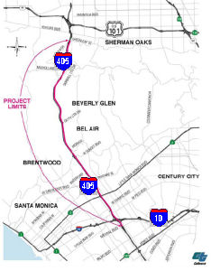 Northbound, there are plans to add an HOV lane between
I-10 and US 101. In September 2000, the California Transportation
Commission considered a proposal (Traffic Congestion Relief Program
Project 39) to add the northbound HOV lane over Sepulveda Pass, from I-10
to US 101. Phase 1 of the proposal was estimated to cost $15 million, with
a total cost of $336 million. This is TCRP Project #39, and has an
estimated completion date sometime in the year 2016, with construction
starting in 2006. The desired goal is 6 mix-flow and 2 HOV lanes in each
direction, but initially there will be one HOV lane and five mixed flow
lanes. It was requested by the LA County Metropolitan Transportation
Authority.
Northbound, there are plans to add an HOV lane between
I-10 and US 101. In September 2000, the California Transportation
Commission considered a proposal (Traffic Congestion Relief Program
Project 39) to add the northbound HOV lane over Sepulveda Pass, from I-10
to US 101. Phase 1 of the proposal was estimated to cost $15 million, with
a total cost of $336 million. This is TCRP Project #39, and has an
estimated completion date sometime in the year 2016, with construction
starting in 2006. The desired goal is 6 mix-flow and 2 HOV lanes in each
direction, but initially there will be one HOV lane and five mixed flow
lanes. It was requested by the LA County Metropolitan Transportation
Authority.
The project will provide a continuous HOV system on Route I-405 by closing a gap in the current system. Estimates to add the HOV lane range from $500 million to $750 million. Work on the environmental phase of the project began in Fiscal Year 2000-01. Severe fiscal crises in the following years resulted in the temporary suspension of various transportation funding sources, including TCRP. Due to the prospective lack of funds to proceed beyond the Environmental phase, the Department delayed work on this project. However, with the appropriation of Proposition 42 funds, and $130,000,000 in new federal earmark funds (SAFETEA-LU), the environmental phase began. During this phase, the Department identifies individual segments for construction. The Federal earmark funds of $130,000,000, along with the remaining un-programmed $75 million of TCRP funds will be used to deliver one or more these segments. The schedule and funding plan are for environmental only. This phase is scheduled to complete in July 2008.
A 2006 bond measure provided additional funding for completion of the northbound HOV route system. This has gone through a lot of funding hurdles, especially in relation to funds from the 2006 Corridor Mobility Improvement Account. Originally, the project was not recommended because it was believed construction would start too late. The decision was later rescinded, and the project was approved for $730 million in funding. The total cost of the project is $950 million. As of March 2007, Caltrans had five proposals for this construction:
Many of these alternatives are engendering quite a bit
of controversy, especially Alternative 3, which would involve the taking
of a significant amount of property, including churches, hotels, and
multi-family residences in an affulent area. Specifically, Caltrans has
noted that the most extensive plan (Alternative 3, about $911 million)
takes up to seven Sherman Oaks homes and thirty Brentwood properties. This
alternative is present because the narrower SB lanes have a higher
accident rate. Alternative 2 (about $649 million) would still take the
seven Sherman Oaks homes, and portions of about forty, and leave the
southbound side of I-405 unchanged.
(Source: Los Angeles Times)
In July 2007, Caltrans released a modification to the plan that appeared more acceptable. This modification would add a mixed flow lane SB between Skirball Center and Waterford St., close the SB I-405 on-ramp from EB Sunset Blvd, reconfiguring the intersection to direct traffic to use the SB entrance just N of Sunset Blvd., and realigning portions of Sepulveda Blvd. There would also be realingment of the Skirball Center ramps.There would also be relocation of the Valley Vista ramps SB. The option would also move I-405 east, permitting a simple narrowing of Church Lane, instead of relocation (and thus saving a lot of properties). In August 2007, the CTC approved programming $27,000,000 in new TCRP funds for Plans, Specifications and Estimates (PS&E) for this project, and changed the Phase 2 completion date to FY10/11. Without widening, traffic on I-405, described as one of the worst in the nation, is forecast to increase 46% from 2005 to 2031.
In February 2008, it was announced that Caltrans had
decided on a plan that will result in only a few homes being taken, in the
vicinity of Valley Vista Blvd. This appears to be the less-severe option
(the July 2007 modification), which itself has had a few modifications.
(Source: LA Daily News, 2/25/2008)
In June 2008, the CTC approved the selected alternative for the Route 405 construction. The alternative selected was Alternative 2: which widens the facility solely to add a NB HOV lane. This alternative will still take seven Sherman Oaks homes, and portions of about forty, but it will leave the southbound side of I-405 unchanged. The NB roadway will meet current design standards for lane, median, and shoulder widths except at the I-10/I-405 interchange and between Moraga Dr. and Sunset Blvd interchanges. Standard lanes consist of an 11' half median, a 12' HOV lane, a 1' HOV buffer, 5 12' mixed-flow lanes, and a 10' outside shoulder. The selected alternative would also widen the SB I-405 to meet current design standards for lane, median, and shoulder widths at certain sections. SB standardization would be within the following segments: Olympic Blvd and Waterford St, and between Bel Air Crest to the north end of the project. Local interchanges within the project limits would be reconstructed and improved notably at Wilshire Blvd, Sunset Blvd, and Skirball Center Drive. There is the goal that wall designs be compatible with the surrounding community. There are also plans to improve wildlife crossings.
In early 2009, it looked like the project might be out
of luck, due to a $730 million shortfall. The project was supposed to
begin in mid-May, largely paid for with bond revenue awarded in 2007.
However, that money was temporarily rescinded in December 2008 as the
Legislature struggled to close a $42 billion deficit. As of April 2009,
the freeway project has about $378 million - including the $200 million in
stimulus money - enough to continue the project for 15 months. About $13
million in local money and $48 million from a state traffic relief program
are secured for the lane. The federal government has kicked in $117
million, separate from the stimulus money, contingent on construction
starting in 2009. The LA MTA eventually decided to start the project,
hoping that they could come up with the money later. Although the MTA has
just a fraction of the project's $1 billion price tag, construction of the
10-mile northbound car-pool lane should begin in summer 2009. The project,
approved by the Los Angeles County Metropolitan Transportation Authority
board, is expected to create some 18,000 construction jobs and be
completed in 2013. The MTA still needs to raise $614 million — money
originally approved by voters in a bond measure but withheld by the state
as it grappled with its massive budget deficit — to complete the
project. In case the remaining money never materializes, the Metro board
agreed to set aside $30 million to cover the costs of suspending or ending
construction contracts. In early May 2009, MTA will award a $712 million
construction contract to Kiewit Pacific Co. for the widening project. With
$372 million in hand, there is enough money to keep the project going for
15 months. That will pay to relocate water, gas and phone lines and work
on some freeway ramp widening.
(Source: LA Daily News, April 2009)
In April 2009, the CTC approved funding this project (as a loan against future bonds) from 2009 Stimulus funds.
Construction on this project started in January 2010. The project includes a 10-mile HOV lane on the northbound I-405 between I-10 and US-101; removal and replacement of the Skirball Center, Sunset Blvd. and Mulholland Dr. bridges; realingment of 27 on and off ramps; widening of 13 existing underpasses and structures; and construction of approximately 18 miles of retaining wall and sound wall. The construction work is quite complicated. Every task - from setting up K-rails and street cones to excavating foothills and readjusting freeway lanes - must be managed between 10p and 6a. Crews must minimize the noise and ensure that their lights don't shine into windows or along wildlife corridors. They must also avoid the inordinate number of oil and gas lines under the route and utility poles alongside the route.
In May 2010, work began on the demolition of the Sunset Blvd bridge. Mostly this has been preparation work: relocation of utilities, restriping of lanes, etc. It was estimated the bridge demolition would begin in mid-May, but as of late June no demolition had started. The plan is to keep the bridge open as it is rebuilt. The southern half of the bridge was completed in July 2010.
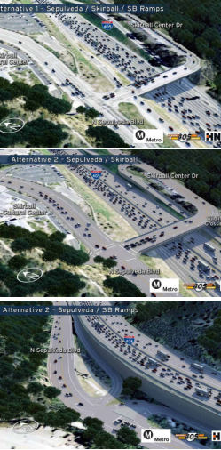 In October 2010, demolition work began on the Skirball Center bridge. Demolition went fast,
and was the northern half was completed in October 2010. There are two
options being considered regarding the Skirball Center ramps. The first
would keep the ramps where they are. The second would relocate the SB
ramps south of the current Skirball bridge. The preferred option, based on
traffic analysis, is the relocation of the ramps. This has the additional
benefits of adding a lane to Skirball Center Drive E of I-405, adding a
sidewalk to the W side of Skirball Center Drive from the new Mulholland
Bridge to the Skirball bridge, adding a sidewalk to the N side of the
bridge, and having more space for bicyclists on the bridge. There will
also be new signage directing visitors to the Skirball Cultural Center, a
dedicated northbound right-turn lane between new SB ramps and Skirball
Bridge, bicycle lanes on Sepulveda Bl between Skirball Bridge and new
southbound ramps, and southbound hook ramps that provide greater ramp
storage capacity. There will also be a dedicated right-turn lane from
northbound Sepulveda Bl onto new southbound I-405 on-ramp, and a dedicated
double left-turn lane from southbound Sepulveda Bl onto southbound I-405.
In October 2010, demolition work began on the Skirball Center bridge. Demolition went fast,
and was the northern half was completed in October 2010. There are two
options being considered regarding the Skirball Center ramps. The first
would keep the ramps where they are. The second would relocate the SB
ramps south of the current Skirball bridge. The preferred option, based on
traffic analysis, is the relocation of the ramps. This has the additional
benefits of adding a lane to Skirball Center Drive E of I-405, adding a
sidewalk to the W side of Skirball Center Drive from the new Mulholland
Bridge to the Skirball bridge, adding a sidewalk to the N side of the
bridge, and having more space for bicyclists on the bridge. There will
also be new signage directing visitors to the Skirball Cultural Center, a
dedicated northbound right-turn lane between new SB ramps and Skirball
Bridge, bicycle lanes on Sepulveda Bl between Skirball Bridge and new
southbound ramps, and southbound hook ramps that provide greater ramp
storage capacity. There will also be a dedicated right-turn lane from
northbound Sepulveda Bl onto new southbound I-405 on-ramp, and a dedicated
double left-turn lane from southbound Sepulveda Bl onto southbound I-405.
In September 2010, it was reported that Caltrans and Metro have finally decided to alter the way the impressively high, 1959-era Mulholland Drive bridge is replaced during the I-405 widening project: they will build an all-new bridge before they tear down the old bridge. This actually saves $4 million to $10 million over juggling the two projects. Coming from the west, drivers would enter the new bridge in the same place they do now, then angle slightly south across the freeway before ending up on Skirball Center Drive. Only after the new span was completed would the old one come down, thus reducing traffic-related inconvenience during construction. However, those plans were changed in early 2011 back to the original approach due to complaints from those in the area. There was concern from residents and environmentalists about increased traffic congestion and threats to wildlife; there were also demands that the new bridge be designed by a world-class architect (which was the deal-breaker, cost-wise, for Metro).
In October 2010, an article was published that highlights the problems in this construction. Consider utility relocation. Shell, Chevron, Exxon and Mobil each have oil pipelines through the pass. SCS Energy has a natural gas pipeline to UCLA. There are fiber optics lines. Southern California Gas Company and Southern California Edison bring gas and electricity to their customers through the pass. Verizon and ATT connect residences and business via the Sepulveda Pass, and the Metropolitan Water District has a 96-inch-diameter water line under Sepulveda Boulevard. Some of those utilities run along and through the three bridges to be replaced—Sunset, Skirball and Mulholland—complicating their demolition and reconstruction.
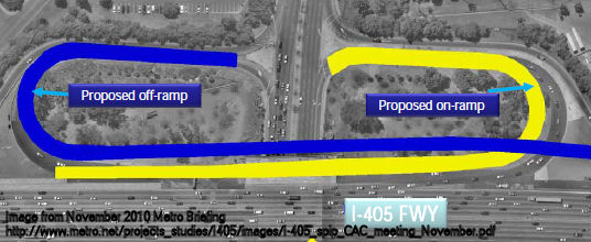 In December 2010, it was reported that the project will involve reconfiguration of the southbound
Wilshire Blvd interchange, adding flyover ramps to eliminate the
intercrossing of exiting and entering traffic. Currently, vehicles trying
to get off the freeway onto Wilshire must jockey with other vehicles
entering the freeway. Under the new configuration, the on ramps and off
ramps are completely separate.
In December 2010, it was reported that the project will involve reconfiguration of the southbound
Wilshire Blvd interchange, adding flyover ramps to eliminate the
intercrossing of exiting and entering traffic. Currently, vehicles trying
to get off the freeway onto Wilshire must jockey with other vehicles
entering the freeway. Under the new configuration, the on ramps and off
ramps are completely separate.
In May 2012, it was reported that the rampture
would begin in June 2012. This is the first 90 day closure of the Wilshire
ramps. This closure includes the Westbound Wilshire on-ramp to Northbound
I-405, and the Northbound I-405 off-ramp to Westbound Wilshire. The six
other Wilshire ramps will be closed consecutively, some two at a time,
between 14 and 90 days. The image below provides additional details:
(Source: Metro.Net)
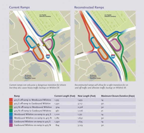 In July 2011 (the weekend of July 15-16), "Carmageddon"
has been predicted as Caltrans closes the entire I-405 freeway roughly
between Sunset Blvd and US 101 in order to demolish half of the Mulholland
Bridge. Details here. The following is a description of how the southbound portion of the bridge
is being demolished:
In July 2011 (the weekend of July 15-16), "Carmageddon"
has been predicted as Caltrans closes the entire I-405 freeway roughly
between Sunset Blvd and US 101 in order to demolish half of the Mulholland
Bridge. Details here. The following is a description of how the southbound portion of the bridge
is being demolished:
The demolition timeline will begin Friday evening, July 15, 2011 when work crews begin closing freeway on- and off-ramps between the I-10 and US 101 as early as 7 p.m. to prevent additional vehicles from entering into the closure area. Crews will then begin closing freeway lanes one by one on both sides of the freeway at 10 p.m. in order to achieve a full freeway closure by midnight. The Mulholland Bridge also will be closed. The area surrounding the Mulholland Bridge will be lit up like the Astrodome utilizing two very large light plants and about 12 regular light plants. Staged in nearby project construction yards and other areas, 15 pieces of heavy construction equipment (with another five on standby) and an army of 100 demolition workers and support staff will be poised to begin their precision operation. Starting at 12 midnight, trucks will begin to haul dirt onto the 405 freeway underneath the Mulholland Bridge to form a cushion four feet high on the freeway roadbed. The dirt will catch falling debris and prevent concrete pieces from damaging the freeway lanes. At approximately 2 a.m. Saturday morning, workers will use a large diamond-bladed saw to cut the bridge top deck and soffit to safely demolish the southern half while keeping the northern half structurally sound. Workers also will cut slots in the southern side of the bridge to quicken the demolition process. During demolition work, workers will perform vibration monitoring and other tests to ensure the structural integrity of the northern side of the bridge is retained at all times. At approximately 5 a.m. Saturday morning, as many as four “hoe rams,” or rolling jack hammers of various sizes will begin to chip away at the south side of the bridge. Approximately 4,000 tons of concrete will be removed in the first phase of demolition work. Two Hoe rams will be stationed on the bridge deck starting in the center working toward each end. Once they have reached the ends of the bridge, two hoe rams will begin to work on the ground also starting in the center and working toward both ends. These giant and powerful demolition machines will deliver between 1,200 and 7,500 foot-pounds of power to break away concrete from the bridge. This compares to 90 foot-pounds delivered by a common hand-held jack hammer. Operators in these machines will be able to deliver between 300 and 600 blows per minute on the concrete decking to break pieces into sizes no bigger than a basketball or microwave oven which can then be easily hauled away from the demolition site. Later, the concrete will be pulverized and recycled. The bridge’s railing will also be taken down by hoe-ram. Front-end loaders will also be used during the demolition to load demolition debris into trucks. While the hoe rams steadily chip away at the concrete, other workers using long-handled oxygen/acetylene torches will cut the steel rebar from the bridge deck amid a crackle of sparks. Workers will be tied to a secure anchor and will be wearing fall protection equipment as they work. Workers will continue to cut the rebar into smaller pieces on the ground so that it can also be recycled. This demolition work is expected to last throughout Sunday, July 17 as crews also demolish the bride’s south columns, leaving the other two columns in-tact to support the north side of the bridge. Once the demolition operation is complete, an army of laborers will thoroughly clean the edge of the bridge to assure that no particles are left to fall on the traffic below. Finally, the remaining portion of the bridge will be inspected by structural engineers from Kiewit and Caltrans. This demo work is expected to last until 2 a.m. Monday morning, July 18, when crews will wrap up demolition and begin their final cleanup to prepare the freeway for reopening by 5 a.m. Between 10 and 20 large trucks and several front end loaders will be used for the cleanup. The freeway surface under the bridge will be cleaned by a parade of street sweepers, inspected, and finally restriped with fresh paint. Ramps and freeway connectors will reopen by 6 a.m.
Debris from the demolished bridges has been used for the construction of the Metro Orange Line in Chatsworth.
The second "carmageddon" occured the weekend of September 29, 2012.
Larry Scholnick provided a good summary of all the work involved in this simple HOV lane addition: The basic goal of the project is to install a northbound HOV (carpool) lane from I-10 (where the NB HOV lane becomes a regular, mixed-flow lane) to US-101 (where the NB HOV lane resumes). No additional regular, mixed-flow lanes will be built; there will continue to be 5/6 NB through lanes (5 South of Skirball Center and 6 North of Skirball Center) and 5/4/5 SB through lanes (5 north of Skirball Center, 4 between Skirball Center and Waterford, and 5 south of Waterford). At first glance it seems like the freeway should only be widened by 12 feet. However, there are currently no center breakdown lanes on either side of the freeway, so this project will add those lanes. At second glance it seems like the freeway will be widened by (12+10+10) 32 feet. However, the existing lanes are about a foot narrower than the current 12-foot standard, so all 10+ existing lanes (5+ NB plus 4+ SB plus one SB-HOV) will we widened by a foot, so the total widening will be over 40 feet. For the section between Olympic and Santa Monica Blvds this is comparatively easy because there is extra right-of-way that was originally intended for the connectors to the (never-built) Beverly Hills (CA-2) Freeway. The interchange with Wilshire Blvd is a full cloverleaf, made up of four onramps and four offramps. Each ramp has a tight turning radius, typical of 1960's construction. In order to eliminate weaving, and to modernize the interchange, all 8 ramps will be torn down and replaced. The ramps will be replaced in pairs; WB-NB & NB-EB will be replaced first. When complete there will be flyover ramps that will eliminate weaving; EB-NB will fly over NB-WB, and SB-EB will fly over WB-SB. The new ramps that include bridges over Sepulveda will leave room for a wider Sepulveda to go under. Every bridge where the freeway crosses OVER a surface street (Exposition, Pico, Olympic, Santa Monica, Ohio, Wilshire, Constitution, Montana, Church, Getty Center, Sepulveda near Getty Center, Bel Air Crest, Sepulveda near Valley Vista and perhaps Ventura) will be widened. All onramps and offramps that are not being replaced will be realigned to the widened freeway. Each bridge where the freeway crosses UNDER a surface street (Sunset, Skirball Center, and Mulholland) will be replaced with a bridge that is wider in both dimensions – room for the wider freeway below and more lanes on the surface street above. In each case the old bridge will be sliced in half (lengthwise), leaving half of the bridge standing while the other half is demolished and replaced. Once the first new half is complete, traffic will be switched to the new half and the other half will be demolished and replaced. The NB Montana offramp will be eliminated, just as its SB counterpart (Waterford) was eliminated several years ago. The convoluted NB ramps at Getty Center will be replaced by regular 'diamond' ramps, similar to the SB ramps at Getty Center. The SB ramps at Skirball Center will be replaced by a new half- interchange along Sepulveda, just north of Mountaingate; the new SB 'Skirball Center' ramps will be about 1/2 mile south of the Skirball Center bridge. In most areas, the centerline of the freeway will not shift significantly; the freeway will be widened by approximately equal amounts on each side; however, since there is no room for widening on the west side of the freeway through the community of Brentwood Glen (where Church Lane, the only north-south road through the area is right next to the west side of the freeway), the entire widening through this area will be on the east side of the freeway. Since Sepulveda is right next to the east side of the freeway, the hillside east of Sepulveda between Montana and Sunset has been torn down; most of the lanes of Sepulveda will be where the hillside was and the freeway widening will cover most of the existing lanes of Sepulveda.
In February 2013, a replacement on-ramp at Skirball Drive to I-405 SB opened. This new ramp is 2,000 feet south of the Skirball Bridge, and is one of the key roadway improvements in this billion dollar freeway widening project. The new ramp provides greater ramp storage capacity for vehicles entering and exiting I-405, as well as providing dedicated turn-lanes on Sepulveda Boulevard for cars entering and exiting the freeway. The construction also provides new bike routes on Sepulveda Boulevard between Skirball Center Drive and the new southbound on- and off-ramps, as well as a simpler design for the Sepulveda Boulevard/Skirball Center Drive intersection, resulting in a safer intersection.
In April 2013, it was reported that the project was
behind schedule. Work on the end sections was proceeding according to
schedule, and the project team has achieved a substantial amount of work
to date, including new Wilshire on and off-ramps, a new and wider Sunset
Bridge, I-10 interchange improvements, Sepulveda Boulevard improvements
and a new on-ramp at Skirball. By the end of 2013, the project anticipates
completing all bridges and utility work will be nearly complete with
project ramps, underpasses, soundwalls and retaining walls. However,
structural failure of miles of new sound walls that had to be demolished
and rebuilt, a legal wrangle over the placement of ramps near the Getty
Center and the complex logistics of finding and relocating more than a
dozen utility lines under Sepulveda Boulevard have created delays. Tthe
project is now slated to take at least a year longer than first
anticipated and cost about $100 million more than the originally budgeted
$1 billion. Officials now aim to complete the bulk of the project by June
2014, with work on the problematic middle segment between Montana Avenue
and Sunset Boulevard lasting perhaps until fall 2014. The delays so
frustrated Elon Musk of SpaceX that he donated $50K to an advocacy group
(although some reports made it seem as if he donated to speed up
construction).
(Source: LA Metro 2/22/13, LosAngeles
Times 4/24/13, LA Times 4/25/13)
In June 2013, it was reported that the construction project is reportedly $100 million over budget and to cover the cost overrun the Metro board asked staff to look into implementing a congestion pricing program for the 405 HOV lanes.
In August 2013, it was reported that Metro is seriously
exploring the idea of a subway/expressway tunnel(s) under I-405 freeway.
Theproject has been fast-tracked; in fact,the transit agency could be
looking for funding partners within a year. Work could begin within 2 to 3
years. To build a tunnel or two of them under the freeway it could take 4
to 5 years. The funding would be from a private-public partnership which
could involve big international construction and financial companies.
Without such a Public Private Partnership (P3) this would have taken 20 to
30 years to pull off. The estimated cost of such a project is in the area
of $10 Billion. There is Measure R tax money of one billion that could be
used. The other 9 would come from private investors (P3) who would get
their money back from expressway tolls if such a roadway is part of the
project and/or fees for subway service. The present thinking is a
train/expressway system that uses two tunnels or one very large one. The
first phase would be through the 10 mile Sepulveda Pass, but it would
eventually be expanded from Sylmar, in the San Fernando Valley, all the
way through to LAX. That would be a 28 mile system. It could be anywhere
from 60 to 90 feet below the surface. Given the steep incline and decline
in the pass distances would vary from one part to another since trains
need to run on a flat surface. The diameter of a tunnel might be 60 to 70
feet depending on whether there is one or two. Unlike the tunneling done
for the Red Line the burrowing equipment is much different and
considerably improved than when our first subway was built. Burrowing so
far underground would also limit disruption to construction weary
residents in the pass. There are no fault lines to present quake problems.
(Source: MyFoxLA, 8/22/13)
In early November 2013, work on the Wilshire ramps was completed and all on- and off-ramps were opened. In late November, the Montana offramp from the NB I-405 was permanently closed (and its removal was started).
In late May 2014, the HOV lanes opened for service, although landscaping, signage, and retaining wall work still remained. Caltrans took the opportunity to provide some statistics on the project. Enough concrete was used on the project to build four Staple Centers, enough dirt was moved to fill 100,000 dump trucks and enough rebar installed to build 15,000 Volkswagen beetles. They also provided the following summary of the improvements:
In November 2016, it was reported that the Metropolitan
Transportation Authority has agreed to pay nearly $300 million more to the
contractor of the I-405 Freeway widening project, capping a years-long
dispute over responsibility for schedule delays, design changes and cost
overruns. The settlement will push the cost of the controversial Sepulveda
Pass project above $1.6 billion, about 55% higher than the original
budget. The $297.8-million agreement follows years of disagreements
between Kiewit Corp. and Metro over how the freeway widening was managed.
Kiewit has said in legal filings that Metro’s repeated changes to
the project’s design and failure to identify and relocate utilities
added significantly to delays.
(Source: LA Times, 11/28/2016)
In March 2015, there were reports that the net
improvements from the I-405 Sepulveda Pass project were negligible. A
traffic study by Seattle-based traffic analytics firm Inrix reported that
auto speeds during the afternoon crawl on the NB I-405 post-project are
the same or slightly slower as pre-project; in fact, the 35-minute tangle
between the 10 and the 101 is actually a minute longer. SB I-405 is so
bad, post-improvements, that when Caltrans issues its "worst bottleneck"
rankings in August, unofficial data suggest that the 10-mile stretch of
I-405 between the Valley and the Westside could be the worst freeway
segment in California. The problem is that a number of studies have shown
that carpooling is declining even as carpool lanes are added, often to the
exclusion of other major transportation projects.
(Source: LA Weekly, 3/4/2015)
In June 2015, the results of another study were
reported. This study was commissioned by Metro from Systems Metric Group
and was the first to compare traffic flow on I-405 before and after the
Sepulveda Pass project that added a northbound carpool lane, rebuilt and
widened bridges and on/off ramps and made other key improvements. The
study showed that: (•) The number of Freeway Service Patrol reported
accidents has dropped, with 15% fewer Freeway Service Patrol reported
accidents in February 2015 compared to Feb. 2009; (•) The afternoon
weekday rush hour now runs from 3 p.m. to 8 p.m. compared to 2 p.m. to 9
p.m. before the project, showing that traffic is at its most congested for
two less hours on weekdays; (•) Vehicle capacity on northbound I-405
has increased from 10,000 vehicles per hour to 11,700 vehicles per hour at
peak times, a 15% increase in vehicle capacity and 30+% increase in people
traveling on this section of I-405; (•) Total travel times are
slightly lower between I-10 and US 101 except during the peak of the
afternoon commute (about 4:30 p.m. to 6:30 p.m.) when travel times are
slightly higher, due in part to a bottleneck backing up traffic further
north at the I-405 and Route 118 interchange; (•) Travel times on
the NB 405 vary less, making travel times are more predictable; and
(•) Traffic on major streets near I-405 — including Sepulveda,
Sunset, Santa Monica, Pico and Ventura — is 20 to 25% lower since
the end of construction. However, the study also showed that commute times
during rush hours increased by about a minute, due to a well-documented
phenomenon called "triple convergence." People who might have otherwise
decided to travel by a different mode, a different route or at a different
time make the decision to use the newly expanded freeway based on the
assumption that it has improved. It's called "induced demand." So even
though Northbound lanes of the freeway can now handle 15% more traffic
every hour - that many more cars are now clogging it. Unfortunately, it is
hard to factor in that "induced demand" when predicting traffic flows in
an expansion project like the I-405 improvement. In its report, Metro said
congestion would have increased 36% if the project hadn't been completed.
(Source: The Source, 5/28/2015, KPCC, 6/4/2015)
Sepulveda Pass - Express/HOT Lanes (~ LA 29.677 to LA 39.2)
 In December 2019, it was reported that the Metropolitan
Transportation Authority is in the early stages of planning to allow solo
drivers in the 405’s carpool lanes, for a price. Similar programs on
portions of Route 110 and Route 10 charge drivers a per-mile toll that
changes based on traffic conditions. The toll lanes would run between I-10
in West L.A. and US 101 in the San Fernando Valley; if approved, officials
say, the lanes would open to drivers in 2027, just before Los Angeles
hosts the 2028 Summer Olympics. In early December, Metro’s board
considered a three-year, $27.5-million contract to move the toll lane
project closer to construction. Metro staff have recommended hiring the
engineering firm WSP USA Inc., formerly Parsons Brinckerhoff, to prepare
an environmental analysis, a traffic study and a detailed cost estimate.
The toll lanes are being developed in parallel with a rail mega-project
through the Sepulveda Pass, which will either be a subway or a monorail,
with an estimated price tag of $9.4 billion to $13.8 billion and a tunnel
as long as 13 miles through the Santa Monica Mountains. The rail project
is funding with about $5.7 billion earmarked from Measure M, the sales tax
increase that county voters approved in 2016, leaving an estimated
shortfall of at least $3.7 billion. Metro officials have previously said
that revenue from the toll lanes could be used to help fund the Sepulveda
Pass rail line by creating a revenue source that Metro could borrow
against. The widening of I-405 added a single carpool lane in each
direction. Metro’s study will examine whether there is enough space
in the freeway’s auxiliary areas to create a second lane for tolled
trips, or whether Metro would have space to convert only the carpool lane
to a single HOT lane. With respect to funding, the toll lanes have $260
million through Measure M, available starting in 2024. The study will
determine whether the project will need to find additional money. The
proposed lanes would be modeled after the Expresslanes on Route 110
between Exposition Park and the South Bay and on I-10 between downtown and
El Monte. Those lanes are free to vehicles with multiple occupants,
provided they have a transponder. Carpools of two or more people on Route 110 get a free ride; on I-10, carpools must have three or more occupants
during peak periods. Drivers who are alone in the car and enter the
ExpressLanes are charged a per-mile price that starts at 25 cents and
rises as congestion in the paid lanes grows worse. The per-mile price,
which Metro has raised seven times since 2012, is now capped at $2.10,
creating a maximum toll of $23.10 on Route 110 and $29.40 on I-10. The
Metro report released earlier in 2019 details several scenarios for the
ExpressLanes, including the possibility that the existing lanes could be
re-striped to make two toll lanes in either direction. Even with just a
single toll lane in either direction, the study projects an increase in
peak-hour travel speeds of up to 31 miles per hour for those who pay the
fee. Traffic speeds in general purpose lanes are also predicted to rise by
up to 9 miles per hour in peak congestion, if fees are imposed on vehicles
with two occupants.
In December 2019, it was reported that the Metropolitan
Transportation Authority is in the early stages of planning to allow solo
drivers in the 405’s carpool lanes, for a price. Similar programs on
portions of Route 110 and Route 10 charge drivers a per-mile toll that
changes based on traffic conditions. The toll lanes would run between I-10
in West L.A. and US 101 in the San Fernando Valley; if approved, officials
say, the lanes would open to drivers in 2027, just before Los Angeles
hosts the 2028 Summer Olympics. In early December, Metro’s board
considered a three-year, $27.5-million contract to move the toll lane
project closer to construction. Metro staff have recommended hiring the
engineering firm WSP USA Inc., formerly Parsons Brinckerhoff, to prepare
an environmental analysis, a traffic study and a detailed cost estimate.
The toll lanes are being developed in parallel with a rail mega-project
through the Sepulveda Pass, which will either be a subway or a monorail,
with an estimated price tag of $9.4 billion to $13.8 billion and a tunnel
as long as 13 miles through the Santa Monica Mountains. The rail project
is funding with about $5.7 billion earmarked from Measure M, the sales tax
increase that county voters approved in 2016, leaving an estimated
shortfall of at least $3.7 billion. Metro officials have previously said
that revenue from the toll lanes could be used to help fund the Sepulveda
Pass rail line by creating a revenue source that Metro could borrow
against. The widening of I-405 added a single carpool lane in each
direction. Metro’s study will examine whether there is enough space
in the freeway’s auxiliary areas to create a second lane for tolled
trips, or whether Metro would have space to convert only the carpool lane
to a single HOT lane. With respect to funding, the toll lanes have $260
million through Measure M, available starting in 2024. The study will
determine whether the project will need to find additional money. The
proposed lanes would be modeled after the Expresslanes on Route 110
between Exposition Park and the South Bay and on I-10 between downtown and
El Monte. Those lanes are free to vehicles with multiple occupants,
provided they have a transponder. Carpools of two or more people on Route 110 get a free ride; on I-10, carpools must have three or more occupants
during peak periods. Drivers who are alone in the car and enter the
ExpressLanes are charged a per-mile price that starts at 25 cents and
rises as congestion in the paid lanes grows worse. The per-mile price,
which Metro has raised seven times since 2012, is now capped at $2.10,
creating a maximum toll of $23.10 on Route 110 and $29.40 on I-10. The
Metro report released earlier in 2019 details several scenarios for the
ExpressLanes, including the possibility that the existing lanes could be
re-striped to make two toll lanes in either direction. Even with just a
single toll lane in either direction, the study projects an increase in
peak-hour travel speeds of up to 31 miles per hour for those who pay the
fee. Traffic speeds in general purpose lanes are also predicted to rise by
up to 9 miles per hour in peak congestion, if fees are imposed on vehicles
with two occupants.
(Source: LA Times, 12/2/2019; CurbedLA,
12/5/2019)
In August and September 2021, scoping meetings were
held with stakeholders regarding HOT/Express Lanes in the Sepulveda Pass.
Metro was working with Caltrans to evaluate alternatives to convert the
existing high occupancy toll (HOV) lanes to dynamically-priced,
high-occupancy toll (HOT) lanes, called ExpressLanes, in both directions
of I-405 between I-10 and US-101. The I-405 Sepulveda Pass ExpressLanes
Project will include a new overhead tolling system and signage on adjacent
portions of the I-405 corridor. The project is in the planning stages and
initiating environmental review to study potential ExpressLanes
alternatives on the I-405 Sepulveda Pass. The environmental review phase
is expected to conclude by fall 2023, with ExpressLanes operation
anticipated in advance of the 2028 Los Angeles Olympic and Paralympic
Games.* As of August 2021, the following alternatives were being
considered as part of the environmental review process that will study how
each performs in accomplishing the project's goals:
(Source: Email from I–405 Express Lanes
Project, "I–405 Sepulveda Pass ExpressLanes: Weekly Update #2",
9/2/2021; Metro Story Map)
In March 2022, the initial scoping summary report on the project was released. The report documented the various notification and outreach activities undertaken in order to increase project awareness and solicit input during the scoping period (August 3, 2021, through October 1, 2021). This report also provided a summary of the comments received during the scoping period. Looking at Figure 6-1 in the report, it appears the largest support was for Alternative 1 (No Build), and opposition to expanding lanes. Of the other alternatives, Alternative 5 had the next largest support, followed by Alternatives 2 and 4.
In August 2023, it was reported that Metro is working
in coordination with the California Department of Transportation
(Caltrans) to evaluate five alternatives to improve transportation in the
Sepulveda Pass, including one no build and four build alternatives, to
convert the existing high-occupancy vehicle (HOV) lanes – or carpool
lanes – to dynamically priced, high-occupancy toll (HOT) lanes,
called ExpressLanes, in both directions of I-405 between I-10 and US-101.
Select alternatives also include the addition of a new lane in each
direction to serve as a second ExpressLane or carpool lane. The proposed
build alternatives are intended to encourage carpooling and transit,
improve trip reliability, reduce degradation of the carpool lanes and
increase person throughput.
(Source: I-405 Sepulveda Pass ExpressLanes Project Newsletter,
9/2/2023)
In June 2012, the CTC relinquished right of way in the city of Los Angeles along Route 405 on Dickens Street, consisting of a collateral facility. (~ LA 38.942)
In January 2010, the CTC approved relinquishment of right of way adjacent to Route 405 in the city of Los Angeles at Dickens Street, consisting of a collateral facility. (~ LA 38.942)
In Fall 2022, LA Metro included, as a potential project in its "I-405
Comprehensive Multimodal Corridor Plan", a proposed project that
will convert the HOV lanes from US 101 to I-5 into ExpressLanes. The
project was ranked in tier 3.
(Source: Los Angeles Metro, "I-405 Comprehensive Multimodal Corridor Plan", Fall 2022, Appendix E: CMCP Projects List)
I-405/US 101 Interchange Improvements (~ LA 39.043 to LA 39.757)
In September 2000, the California Transportation Commission considered a proposal (TCRP Project 51) to add an auxiliary lane and widen the ramp through the I-405/US 101 freeway interchange in Sherman Oaks (~ LA 39.043 to LA 39.757). For phases 1 and 2, the request was for $4 million, with a total estimated cost of $34 million. The phase 3 request was $4.2 million. Phase 1 added a northbound auxilliary freeway lane from Mulholland Drive to Greenleaf Avenue, and was completed around January 2003. The third phase was completed in 2004 and widened the eastbound connector to the US 101 to two lanes. The third phase involves permanently closing the ramp that loops motorists from eastbound Ventura Boulevard onto the northbound I-405 near the Sherman Oaks Galleria. The reconstructed approach routes motorists onto southbound Sepulveda Boulevard and onto Greenleaf Avenue, where they will either drive through a tunnel under the freeway and onto the NB I-405, or stay in the right lane and connect to US 101. It was completed in late 2007.
![[SB 405/101 IC]](maps/405-sb101ic.jpg) There is also work
afoot to address another problem at that interchange -- specifically, the
connector between southbound I-405 and the northbound US 101. This might
involve construction of an elevated two-lane connector. There are five
options currently under consideration, some of which could affect nearby
homes or take out part of the Sepulveda Basin wildlife refuge. The
connection between two freeways is now just one lane and often backs up on
I-405. The project would build a two-lane connector across the Sepulveda
Dam spillway, and could possibly include changes to southbound I-405 and
the southbound US-101 interchange, and the Burbank Boulevard
on-and-off-ramps. Built in the 1950s, the freeway connector was designed
to handle up to 1,500 vehicles an hour but now has been swamped with 1,790
autos per hour by 2008. By 2015, morning rush hours are expected to draw
up to 2,075 vehicles per hour to the freeway connector as the state
population increases. One of the three possible alternatives reconstructs
the Burbank Boulevard on-ramp to southbound I-405 to pass beneath the new
two-lane connector, at an estimated cost of $86.4 million. However,
Burbank Boulevard would lose access to both directions of US 101. As a
result, the Los Angeles Department of Transportation opposes the plan.
Closing that freeway access will send traffic farther down to Van Nuys
Boulevard or through the congested intersection of Sepulveda and Burbank
boulevards, said Ken Husting, a senior transportation engineer with LADOT.
With this alternative, LADOT engineers want to see other roadway
improvements to increase mobility, such as building a full interchange at
Hayvenhurst Avenue to US 101. The other alternatives stretch into the
225-acre Sepulveda Basin wildlife refuge - home to various species of
birds, from burrowing owls to red-tailed hawks and Canada geese - within
the Sepulveda Flood Control Basin. A second proposal, estimated at $117
million, maintains access to US 101 from Burbank Boulevard, but it
requires a new loop on-ramp that encroaches on 2.64 acres of wildlife
refuge sitting north of Burbank Boulevard and west of I-405. The plan also
requires reconstruction of the bridge between Burbank Boulevard and I-405.
A third alternative, costing about $88.8 million (and supported by
Homeowners of Encino) leaves access to US 101 open from Burbank Boulevard
but takes 2.92 acres of the wildlife refuge. This plan excludes
reconstructing an existing overcrossing between Burbank Boulevard. The
Army Corps of Engineer oppose the 2nd and 3rd alternatives, as do
environmental groups. The plans will be discussed at the June 2008 CTC
meeting.
There is also work
afoot to address another problem at that interchange -- specifically, the
connector between southbound I-405 and the northbound US 101. This might
involve construction of an elevated two-lane connector. There are five
options currently under consideration, some of which could affect nearby
homes or take out part of the Sepulveda Basin wildlife refuge. The
connection between two freeways is now just one lane and often backs up on
I-405. The project would build a two-lane connector across the Sepulveda
Dam spillway, and could possibly include changes to southbound I-405 and
the southbound US-101 interchange, and the Burbank Boulevard
on-and-off-ramps. Built in the 1950s, the freeway connector was designed
to handle up to 1,500 vehicles an hour but now has been swamped with 1,790
autos per hour by 2008. By 2015, morning rush hours are expected to draw
up to 2,075 vehicles per hour to the freeway connector as the state
population increases. One of the three possible alternatives reconstructs
the Burbank Boulevard on-ramp to southbound I-405 to pass beneath the new
two-lane connector, at an estimated cost of $86.4 million. However,
Burbank Boulevard would lose access to both directions of US 101. As a
result, the Los Angeles Department of Transportation opposes the plan.
Closing that freeway access will send traffic farther down to Van Nuys
Boulevard or through the congested intersection of Sepulveda and Burbank
boulevards, said Ken Husting, a senior transportation engineer with LADOT.
With this alternative, LADOT engineers want to see other roadway
improvements to increase mobility, such as building a full interchange at
Hayvenhurst Avenue to US 101. The other alternatives stretch into the
225-acre Sepulveda Basin wildlife refuge - home to various species of
birds, from burrowing owls to red-tailed hawks and Canada geese - within
the Sepulveda Flood Control Basin. A second proposal, estimated at $117
million, maintains access to US 101 from Burbank Boulevard, but it
requires a new loop on-ramp that encroaches on 2.64 acres of wildlife
refuge sitting north of Burbank Boulevard and west of I-405. The plan also
requires reconstruction of the bridge between Burbank Boulevard and I-405.
A third alternative, costing about $88.8 million (and supported by
Homeowners of Encino) leaves access to US 101 open from Burbank Boulevard
but takes 2.92 acres of the wildlife refuge. This plan excludes
reconstructing an existing overcrossing between Burbank Boulevard. The
Army Corps of Engineer oppose the 2nd and 3rd alternatives, as do
environmental groups. The plans will be discussed at the June 2008 CTC
meeting.
(Source: LA Daily News], May 8, 2008; Project EIR)
In September 2008, the CTC considered the above project for future consideration of funding. The cover information noted that the project will replace the existing connector by constructing a new connector/bridge over the Sepulveda Dam. The project is not fully funded. The project is programmed in the 2008 State Transportation Improvement Program with regional improvement program shares for $7,010,000 for environmental. The total estimated project cost is $165 million. Construction is estimated to begin in Fiscal Year 2013-14, depending on the availability of funds.
In April 2012, it was reported that widening and
retrofitting of the Sepulveda Overpass was going to begin in May 2012. For
about a year, left turns from Fiume Walk and the Southbound Valley Vista
off-ramp onto northbound Sepulveda will be restricted, and left turns from
northbound Sepulveda onto Fiume Walk will also be restricted.
Additionally, the left turn pocket onto the southbound Valley Vista
on-ramp will be shortened and Sepulveda will go to two lanes in each
direction near the overpass. Meanwhile, two crosswalks will be
eliminated—the crosswalk across Sepulveda at Fiume Walk and the
crosswalk across Fiume which, along with sidewalk on the west side of
Sepulveda, will close three months after the start of construction.
(Source: Zev Yaroslavsky's Blog, 4/27/2012)
In Fall 2022, LA Metro included, as a potential project
in its "I-405 Comprehensive Multimodal Corridor Plan", a vaguely
defined project that will improve the I-405/US 101 interchange. The
project was ranked in tier 3.
(Source: Los Angeles Metro, "I-405 Comprehensive Multimodal Corridor Plan", Fall 2022, Appendix E: CMCP Projects List)
Southbound Ventura Blvd Interchange (07-LA-405 PM 39.1)
The following project was included in the final adopted 2018 SHOPP in March 2018: PPNO 2681. 07-Los Angeles-405 39.1. Route 405 In the community of Sherman Oaks, at southbound onramp from Ventura Boulevard. Widen the onramp to two lanes plus a High Occupancy Vehicle (HOV) lane. Begin Con: 7/15/2022. Total Project Cost: $7,336K.
In March 2020, the CTC approved a financial allocation
for 07-LA-405 PM 39.1. PPNO 2681. ProjID 0717000022. EA 20490. I-405 in
the city of Sherman Oaks, at southbound onramp from Ventura Boulevard.
Widen the onramp to two lanes plus a High Occupancy Vehicle (HOV) lane.
21-22 PS&E $1,918,000 $1,918,000 R/W Sup $141,000 $141,000.
(Source: March 2020 CTC Agenda, Agenda Item
2.5b.(2a) #23)
The 2020 SHOPP, approved in May 2020, included the
following Mobility item of interest (carried over from the 2018 SHOPP):
07-LA-405 PM 39.1 PPNO 2681 Proj ID 0717000022 EA 20490. I-405 in the city
of Los Angeles, in the neighborhood of Sherman Oaks, at the southbound
onramp from Ventura Boulevard. Widen the onramp to two lanes plus a High
Occupancy Vehicle (HOV) lane. Programmed in FY21-22, with construction
scheduled to start in July 2022. Total project cost is $7,336K, with
$3,149K being capital (const and right of way) and $4,187K being support
(engineering, environmental, etc.).
(Source: 2020 Approved SHOPP a/o May 2020)
In August 2022, the CTC approved the following
construction phase allocation: $4,451,000. 07-LA-405 39.1. PPNO 07-2681;
ProjID 0717000022; EA 20490. I-405 In the city of Los Angeles, in the
neighborhood of Sherman Oaks, at the southbound onramp from Ventura
Boulevard. Outcome/Output: Widen the onramp from two lanes to
three metered lanes to help reduce congestion. Programmed allocation: CON
ENG $1,343,000; CONST $3,120,000. CEQA - CE, 2/20/2020; Re-validation
4/29/2022. NEPA - CE, 2/20/2020; Re-validation 4/29/2022. Two month time
extension for CONST and CON ENG approved under Waiver 22-73; June 2022.
(Source: August 2022 CTC Agenda, Agenda Item
2.5b.(1) #53)
In Fall 2022, LA Metro included, as a potential project in its "I-405
Comprehensive Multimodal Corridor Plan", a proposed project that
will build an interchange at I-405 and Oxnard Street, including a Metro
Orange Line to HOV connection. The project was ranked in tier 3.
(Source: Los Angeles Metro, "I-405 Comprehensive Multimodal Corridor Plan", Fall 2022, Appendix E: CMCP Projects List)
In August 2022, it was reported that Metro and Caltrans have announed the
completion of 5.4 miles of new sound walls along Route 170 and I-405 in
the North Hollywood area of Los Angeles. The new $103-million sound wall
project provides freeway noise relief to the residents of North Hollywood,
Valley Glen and Valley Village. Sound walls were completed specifically
along Route 170 from US 101 (~ 07-LA-170 R14.649) to Sherman Way (~
07-LA-170 R18.277), and along I-405 from Saticoy Avenue (~ 07-LA-405
42.883) to Roscoe Boulevard (~ 07-LA-405 43.781). The project also
included the widening of eight bridges to support the sound walls without
widening the lanes. Construction of this sound wall project began in 2017
and as of August 2022 was substantially complete. The project team will
later add landscaping to help stabilize the slopes and beautify the
right-of-way. Plantings are expected to be completed by fall 2023. New
sound walls were funded by Metro’s 2008 voter-approved Measure R
transportation sales tax measure as well as Proposition C that was passed
by county voters in 1990. What is interesting about this project is that
it was primarily a Metro project, not Caltrans. With the passage of Senate
Bill (SB)-45, the California Street and Highway Code was amended to
transfer the programming and funding responsibilities of the Post 1989
Soundwall Retrofit Program to Regional Transportation Planning Agencies.
In LA County, Metro assumed this responsibility. However, the
eligibility determination as well as design and construction
responsibilities for the program remained with the California Department
of Transportation (Caltrans). Metro inherited a backlog of soundwall
projects totaling nearly $1 billion without any corresponding funding from
the state.
(Source: Metro "The Source" 8/4/2022, Metro "Highway Soundwalls" 9/17/2022)
 Commuter Lanes
Commuter lanes exist or are planned for this route in the following areas.
Northbound:
Southbound:
All lanes require two or more occupants, and are always in operation.
 Naming
 This route is named the "San Diego Freeway"; the first portion opened in 1957; the last in 1969. It was named by the State
Highway Commission on November 18, 1954. San Diego refers to the eventual
southern terminus of the route (after all merges). The name refers to
Saint Didacus of Alcalá, a Franciscan saint of the 15th century. The
bay was named by Vizcaíno in 1602, the mission in 1769, the county in
1850 and the new city in 1856. The name was likely given to encourage
people to take the I-405 bypass of downtown to go to San Diego (connecting
with I-5 to the S).
This route is named the "San Diego Freeway"; the first portion opened in 1957; the last in 1969. It was named by the State
Highway Commission on November 18, 1954. San Diego refers to the eventual
southern terminus of the route (after all merges). The name refers to
Saint Didacus of Alcalá, a Franciscan saint of the 15th century. The
bay was named by Vizcaíno in 1602, the mission in 1769, the county in
1850 and the new city in 1856. The name was likely given to encourage
people to take the I-405 bypass of downtown to go to San Diego (connecting
with I-5 to the S).
(Image source: Water and Power; OC Register; Catholic Online)
 Waller Memorial Highway") The portion of I-405 from just S of San Diego
Creek (South Fork), just S of Route 133 and San Diego Creek, North Fork,
NW of Harvard Ave) ( ~ ORA 1.525 to ORA 6.459) in the County of Orange is
named the "James Mitchell “Mitch” Waller Memorial Highway".
It was named in memory of James Mitchell “Mitch” Waller, who
was born in September 1959, in Dallas, Texas. In 1965, Waller and his
family moved to Huntington Beach, California, where he began his
education. Waller joined the Boy Scouts of America as a Cub Scout in his
early school years and continued to participate in the organization as a
Boy Scout through high school, earning the prestigious rank of Eagle
Scout. Waller graduated from Edison High School in 1977. He continued his
education at the University of California, San Diego and graduated in 1983
with a bachelor of arts degree in Biochemistry and Cellular Biology and a
minor in Economics. Waller attended the Criminal Justice Training Center
at Golden West College, after which he began his career in law enforcement
with the City of Westminster Police Department in 1984. While continuing
his duties with the City of Westminster Police Department, Waller attended
Chapman University School of Law in 1995. He completed his juris doctor
degree and passed the California Bar in 1999. In 2003, he was selected to
attend the Federal Bureau of Investigation National Academy in Quantico,
Virginia. As a community leader, Waller rose through the ranks to become
Chief of Police for the Westminster Police Department. He served the law
enforcement and safety communities for 27 years. Waller remained committed
to the Westminster community and worked to develop positive staff
relations, communications, and infrastructure. Under his direction, the
new Westminster Police Department building was completed in 2011, on time
and under budget—an accomplishment of which he was very proud.
Waller accepted an appointment to the office of the Westminster City
Manager in 2011, and he retired in 2012. In his neighborhood in the
community of Mission Viejo, Waller was known for generosity with both his
time and talents. He was very active in his daughter softball teams,
supporting them with everything from coaching assistance to first aid. For
his son, Mitch assisted with his training for the high school
cross-country and track teams, always there to offer his encouragement and
support. The exemplary life of Mitch Waller ended tragically in an
accident on the morning of Friday, June 28, 2013, at 53 years of age,
while he was cycling with his good friend in the bike lane on Route 133,
heading toward Laguna Beach—a favorite destination. Named by
Assembly Concurrent Resolution (ACR) 65, Res. Chapter 169, Statutes of
2015, on September 10, 2015.
The portion of I-405 from just S of San Diego
Creek (South Fork), just S of Route 133 and San Diego Creek, North Fork,
NW of Harvard Ave) ( ~ ORA 1.525 to ORA 6.459) in the County of Orange is
named the "James Mitchell “Mitch” Waller Memorial Highway".
It was named in memory of James Mitchell “Mitch” Waller, who
was born in September 1959, in Dallas, Texas. In 1965, Waller and his
family moved to Huntington Beach, California, where he began his
education. Waller joined the Boy Scouts of America as a Cub Scout in his
early school years and continued to participate in the organization as a
Boy Scout through high school, earning the prestigious rank of Eagle
Scout. Waller graduated from Edison High School in 1977. He continued his
education at the University of California, San Diego and graduated in 1983
with a bachelor of arts degree in Biochemistry and Cellular Biology and a
minor in Economics. Waller attended the Criminal Justice Training Center
at Golden West College, after which he began his career in law enforcement
with the City of Westminster Police Department in 1984. While continuing
his duties with the City of Westminster Police Department, Waller attended
Chapman University School of Law in 1995. He completed his juris doctor
degree and passed the California Bar in 1999. In 2003, he was selected to
attend the Federal Bureau of Investigation National Academy in Quantico,
Virginia. As a community leader, Waller rose through the ranks to become
Chief of Police for the Westminster Police Department. He served the law
enforcement and safety communities for 27 years. Waller remained committed
to the Westminster community and worked to develop positive staff
relations, communications, and infrastructure. Under his direction, the
new Westminster Police Department building was completed in 2011, on time
and under budget—an accomplishment of which he was very proud.
Waller accepted an appointment to the office of the Westminster City
Manager in 2011, and he retired in 2012. In his neighborhood in the
community of Mission Viejo, Waller was known for generosity with both his
time and talents. He was very active in his daughter softball teams,
supporting them with everything from coaching assistance to first aid. For
his son, Mitch assisted with his training for the high school
cross-country and track teams, always there to offer his encouragement and
support. The exemplary life of Mitch Waller ended tragically in an
accident on the morning of Friday, June 28, 2013, at 53 years of age,
while he was cycling with his good friend in the bike lane on Route 133,
heading toward Laguna Beach—a favorite destination. Named by
Assembly Concurrent Resolution (ACR) 65, Res. Chapter 169, Statutes of
2015, on September 10, 2015.
(Image source: Mission Viejo Reporter: OC Register)
 The portion of I-405 northbound
in the County of Orange between Magnolia Street and Brookhurst Street (~
ORA 15.210 to ORA 13.780), is designated the "Lt. Colonel Nguyen Thi
Hanh Nhon Disabled Veterans Memorial Highway". It was named in
memory of Nguyen Thi Hanh Nhon, who was born in 1927 in Hue, Việt
Nam, a daughter of a field marshal of the Nguyen Dynasty. Ms. Nguyen was
married to Ly Nhut Huong, a businessman, and was the mother of nine
children. In 1950, when the French came to Việt Nam and formed the
Corps of Female Assistants, consisting of office secretaries, nurses, and
social workers, Ms. Nguyen enlisted and served in the corps. When the
American forces arrived in Việt Nam, this corps became the Corps of
Female Soldiers and served under the regime of the South Vietnamese Armed
Forces until 1975. At the time, Ms. Nguyen served as a Lieutenant (Lt.)
Colonel of the Air Force of the Republic of Vietnam at the Air Force
Headquarters at Tan Son Nhut Airbase. After the fall of Saigon in 1975,
Lt. Colonel Nguyen was imprisoned in a reeducation camp for nearly five
years and suffered hard labor in the forest with access to little food and
water, and lived in horrific conditions. After her release, she had little
options left but to find work in any capacity, from selling ice cream to
selling home construction materials to support her family. In 1990, one of
her sons sponsored her to come to the United States via the Humanitarian
Operation under the Orderly Departure Program and she became a resident of
the City of Garden Grove. In 1991, Lt. Colonel Nguyen joined the Mutual
Society of Political Prisoners and served as its Vice President to help
those in Việt Nam who qualified under the Humanitarian Operation to
come to the United States. Once those qualifying under the Humanitarian
Operation arrived in the United States, Lt. Colonel Nguyen helped them
find work and housing, enrolled children in schools, and more importantly,
helped them to adjust to life in America. These community efforts were
instrumental in providing new immigrants with the tools to acclimate and
become self-sufficient. In 1994, when the Humanitarian Operation ended,
Lt. Colonel Nguyen and the group organized a Humanitarian Operation Mutual
Society for Việt Nam Wounded Veterans, of which she became president
in 2006. Through this organization, Lt. Colonel Nguyen assisted disabled
Veterans of the Republic of Vietnam who were still in Việt Nam
facing financial difficulties and raised awareness to help the wounded
soldiers in Việt Nam. In 2006, as the needs to serve many disabled
veterans in Việt Nam increased, Lt. Colonel Nguyen organized the
“Cam On Anh” Annual Concert in the City of Garden Grove,
California, to raise funds to send money back to Việt Nam for
disabled veterans. Over the past 10 years, Lt. Colonel Nguyen has helped
serve over 22,000 disabled veterans of the Army of the Republic of
Vietnam. In addition to her work in support of veterans, Lt. Colonel
Nguyen helped educate students about the impacts of the Vietnam War and
contributed her life story to the University of California, Irvine
Vietnamese American Heritage Foundation Oral Histories Project. Lt.
Colonel Nguyen was an active member of several community-based
organizations dedicated to improving the lives of Vietnamese Americans in
the County of Orange and throughout the State of California. On April 18,
2017, Lt. Colonel Nguyen passed away at the age of 90, leaving a strong
legacy of community service for the residents of California’s 34th
Senate District. Named by Senate Concurrent Resolution 60, Resolution
Chapter 178, 9/22/2017.
The portion of I-405 northbound
in the County of Orange between Magnolia Street and Brookhurst Street (~
ORA 15.210 to ORA 13.780), is designated the "Lt. Colonel Nguyen Thi
Hanh Nhon Disabled Veterans Memorial Highway". It was named in
memory of Nguyen Thi Hanh Nhon, who was born in 1927 in Hue, Việt
Nam, a daughter of a field marshal of the Nguyen Dynasty. Ms. Nguyen was
married to Ly Nhut Huong, a businessman, and was the mother of nine
children. In 1950, when the French came to Việt Nam and formed the
Corps of Female Assistants, consisting of office secretaries, nurses, and
social workers, Ms. Nguyen enlisted and served in the corps. When the
American forces arrived in Việt Nam, this corps became the Corps of
Female Soldiers and served under the regime of the South Vietnamese Armed
Forces until 1975. At the time, Ms. Nguyen served as a Lieutenant (Lt.)
Colonel of the Air Force of the Republic of Vietnam at the Air Force
Headquarters at Tan Son Nhut Airbase. After the fall of Saigon in 1975,
Lt. Colonel Nguyen was imprisoned in a reeducation camp for nearly five
years and suffered hard labor in the forest with access to little food and
water, and lived in horrific conditions. After her release, she had little
options left but to find work in any capacity, from selling ice cream to
selling home construction materials to support her family. In 1990, one of
her sons sponsored her to come to the United States via the Humanitarian
Operation under the Orderly Departure Program and she became a resident of
the City of Garden Grove. In 1991, Lt. Colonel Nguyen joined the Mutual
Society of Political Prisoners and served as its Vice President to help
those in Việt Nam who qualified under the Humanitarian Operation to
come to the United States. Once those qualifying under the Humanitarian
Operation arrived in the United States, Lt. Colonel Nguyen helped them
find work and housing, enrolled children in schools, and more importantly,
helped them to adjust to life in America. These community efforts were
instrumental in providing new immigrants with the tools to acclimate and
become self-sufficient. In 1994, when the Humanitarian Operation ended,
Lt. Colonel Nguyen and the group organized a Humanitarian Operation Mutual
Society for Việt Nam Wounded Veterans, of which she became president
in 2006. Through this organization, Lt. Colonel Nguyen assisted disabled
Veterans of the Republic of Vietnam who were still in Việt Nam
facing financial difficulties and raised awareness to help the wounded
soldiers in Việt Nam. In 2006, as the needs to serve many disabled
veterans in Việt Nam increased, Lt. Colonel Nguyen organized the
“Cam On Anh” Annual Concert in the City of Garden Grove,
California, to raise funds to send money back to Việt Nam for
disabled veterans. Over the past 10 years, Lt. Colonel Nguyen has helped
serve over 22,000 disabled veterans of the Army of the Republic of
Vietnam. In addition to her work in support of veterans, Lt. Colonel
Nguyen helped educate students about the impacts of the Vietnam War and
contributed her life story to the University of California, Irvine
Vietnamese American Heritage Foundation Oral Histories Project. Lt.
Colonel Nguyen was an active member of several community-based
organizations dedicated to improving the lives of Vietnamese Americans in
the County of Orange and throughout the State of California. On April 18,
2017, Lt. Colonel Nguyen passed away at the age of 90, leaving a strong
legacy of community service for the residents of California’s 34th
Senate District. Named by Senate Concurrent Resolution 60, Resolution
Chapter 178, 9/22/2017.
(Image source: Người Việt Online; Thanh Thúy)
 The portion of I-405 between just SE of the Route 22 interchange and Bolsa
Chica Road and the San Gabriel River overcrossing, just NW of I-605
interchange (~ ORA 20.4 to ORA 24.178) in the County of Orange is named
the "Kevin Woyjeck Memorial Highway" (signed as "Hotshot
Firefigher Kevin J. Woyjeck Memorial Highway"). As the son of a
captain in the Los Angeles County Fire Department, the grandson of a
smokejumper, and the eighth firefighter in the Woyjeck family, Kevin
Woyjeck knew from an early age that he wanted to be a firefighter. Kevin
grew up in Seal Beach, California, and attended McGaugh Elementary School
in Seal Beach and McAuliffe Middle School and Los Alamitos High School,
both in Los Alamitos, California. He spent every summer for nine years as
a Seal Beach Junior Lifeguard. When he was 15 years old, Kevin joined the
Los Angeles County Fire Department Explorer Program. Kevin became an
emergency medical technician while in high school and worked on an
ambulance crew shortly after graduating. Kevin had extensive training as a
firefighter, having taken firefighting classes at Santa Ana College, El
Camino College Structure Fire Academy, and the Department of Forestry and
Fire Protection Academy in San Luis Obispo. Kevin also spent a season in
South Dakota, where he joined the Johnson Valley Volunteer Fire Department
and performed indirect wildland firefighting for the South Dakota Wildland
Fire Division as part of a Type 2-IA Handcrew. In April 2013, Kevin was
honored to join the Granite Mountain Hotshots, an elite crew of 20 young
men in top condition, based in Prescott, Arizona, who had direct wildland
firefighting responsibilities with the ability to provide service anywhere
in the nation. After successfully fighting fires and saving lives and
property in New Mexico and Arizona, Kevin and the other members of the
crew responded to an out-of-control fire in Yarnell, Arizona, on June 30,
2013. Nineteen of the twenty young men in the Granite Mountain Hotshots
tragically lost their lives in the fire, including Kevin. Named by
Assembly Concurrent Resolution (ACR) 100, Res. Chapter 116, Statutes of
2016 on August 16, 2016.
The portion of I-405 between just SE of the Route 22 interchange and Bolsa
Chica Road and the San Gabriel River overcrossing, just NW of I-605
interchange (~ ORA 20.4 to ORA 24.178) in the County of Orange is named
the "Kevin Woyjeck Memorial Highway" (signed as "Hotshot
Firefigher Kevin J. Woyjeck Memorial Highway"). As the son of a
captain in the Los Angeles County Fire Department, the grandson of a
smokejumper, and the eighth firefighter in the Woyjeck family, Kevin
Woyjeck knew from an early age that he wanted to be a firefighter. Kevin
grew up in Seal Beach, California, and attended McGaugh Elementary School
in Seal Beach and McAuliffe Middle School and Los Alamitos High School,
both in Los Alamitos, California. He spent every summer for nine years as
a Seal Beach Junior Lifeguard. When he was 15 years old, Kevin joined the
Los Angeles County Fire Department Explorer Program. Kevin became an
emergency medical technician while in high school and worked on an
ambulance crew shortly after graduating. Kevin had extensive training as a
firefighter, having taken firefighting classes at Santa Ana College, El
Camino College Structure Fire Academy, and the Department of Forestry and
Fire Protection Academy in San Luis Obispo. Kevin also spent a season in
South Dakota, where he joined the Johnson Valley Volunteer Fire Department
and performed indirect wildland firefighting for the South Dakota Wildland
Fire Division as part of a Type 2-IA Handcrew. In April 2013, Kevin was
honored to join the Granite Mountain Hotshots, an elite crew of 20 young
men in top condition, based in Prescott, Arizona, who had direct wildland
firefighting responsibilities with the ability to provide service anywhere
in the nation. After successfully fighting fires and saving lives and
property in New Mexico and Arizona, Kevin and the other members of the
crew responded to an out-of-control fire in Yarnell, Arizona, on June 30,
2013. Nineteen of the twenty young men in the Granite Mountain Hotshots
tragically lost their lives in the fire, including Kevin. Named by
Assembly Concurrent Resolution (ACR) 100, Res. Chapter 116, Statutes of
2016 on August 16, 2016.
(Image source: LA County Fire; Press Telegram)
 Giniewicz Memorial Highway") The portion of I-405 from Cherry Avenue south to Atlantic Avenue in the County
of Los Angeles (~ LA 4.867 to LA 6.071), is named the "Signal Hill
Police Officer Anthony “Tony” Giniewicz Memorial Highway".
It was named in memory of Officer Anthony “Tony” Giniewicz,
who faithfully served the Signal Hill Police Department and the residents
of the City of Signal Hill as a police officer assigned to patrol
operations. Officer Giniewicz was shot in the line of duty by three gang
members while responding to a robbery in progress at a restaurant in the
City of Long Beach on February 19, 1985. Officer Giniewicz was paralyzed
from the chest down as a result of his wounds and remained in poor health
until passing away as a result of complications on December 7, 2011. Named
by Senate Concurrent Resolution 84, Resolution Chapter 89, on July 9,
2014.
The portion of I-405 from Cherry Avenue south to Atlantic Avenue in the County
of Los Angeles (~ LA 4.867 to LA 6.071), is named the "Signal Hill
Police Officer Anthony “Tony” Giniewicz Memorial Highway".
It was named in memory of Officer Anthony “Tony” Giniewicz,
who faithfully served the Signal Hill Police Department and the residents
of the City of Signal Hill as a police officer assigned to patrol
operations. Officer Giniewicz was shot in the line of duty by three gang
members while responding to a robbery in progress at a restaurant in the
City of Long Beach on February 19, 1985. Officer Giniewicz was paralyzed
from the chest down as a result of his wounds and remained in poor health
until passing away as a result of complications on December 7, 2011. Named
by Senate Concurrent Resolution 84, Resolution Chapter 89, on July 9,
2014.
(Image source: Signal Hill Police Department; Find a Grave)
 The portion of I-405 from South
Western Avenue to Redondo Beach Boulevard in the County of Los Angeles (~
LA 14.476 to LA 16.889) is named the "Louis Zamperini Memorial Highway".
Louis Silvie Zamperini was born in January 1917, in Olean, New York, to
Italian immigrants Anthony Zamperini and Louise Dossi. Zamperini’s
family moved to Torrance, California, in 1919. Louis Zamperini learned to
box before he became a runner. His father taught him how to box so he
could defend himself against bullies who taunted him because he could not
speak English. Pete Zamperini, his older brother, encouraged him to try
out for the track team at Torrance High School. Louis Zamperini set the
national high school record in the mile at the Los Angeles Memorial
Coliseum in 1934, earning him the nickname of the “Torrance
Tornado.” His record time of 4 minutes, 21.2 seconds stood for 20
years. His schoolboy exploits on the track team earned him a scholarship
to the University of Southern California. Two years later, in the
5,000-meter Olympic trials at Randalls Island in New York, Louis Zamperini
finished in a dead heat with Don Lash, the world-record holder, which
qualified him for the 1936 Olympics in Berlin as a teenager, alongside
such Olympians as Jesse Owens, Ralph Metcalfe, and Mack Robinson, the
older brother of Jackie Robinson. Two years later, in 1938, Louis
Zamperini set a national collegiate mile record of 4:08.3, which stood for
15 years. He subsequently graduated from the University of Southern
California, and not long after that, when World War II broke out, he
enlisted in September 1941 in the United States Army Air Corps and became
a bombardier on a Consolidated B-24 bomber in the Pacific theater of
operations. During a search and rescue mission to save a downed pilot,
Louis Zamperini’s airplane crashed due to mechanical failure, and he
and two other airmen were the only survivors of the 11-man crew on board
the airplane. One of the men died after 33 days, and Louis Zamperini and
the other airman were stranded on a raft for a total of 47 days before
washing ashore on a Pacific island and being taken as prisoners of war
(POWs) by the Japanese. Louis Zamperini was tortured for the next two
years and was only released and returned to the United States after the
end of the war in the Pacific in 1945. After the war, he founded a camp
for troubled youths called the Victory Boys Camp. Louis Zamperini married
in 1946 and remained married until his wife's death in 2001. His marriage
became strained because of his nightmares reliving his World War II
experiences, and he began drinking heavily, trying to forget his
experiences as a POW. In 1949, at the encouragement of his wife, Louis
Zamperini reluctantly agreed to attend a Billy Graham crusade.
Graham’s preaching reminded him of his prayers during his time on
the life raft and his imprisonment, and Zamperini recommitted his life to
Christ. Following this, he forgave his Japanese tormentors, and his
nightmares ceased. Louis Zamperini was a defiant, resourceful, and
determined man. He became an Olympic athlete and survived a plane crash,
being lost at sea, and the worst of a Japanese prisoner-of-war camp during
World War II. In 1998, he carried the Olympic torch at the Winter Olympics
held in Nagano, Japan. He also spent the last 65 years of his life sharing
his faith and his philosophy of life with as many audiences as would
invite him to speak. In his talks, he included the concepts of
forgiveness, hardiness, preparation, and a new life in Christ. Louis
Zamperini was also quick-witted, fun-loving, humble, and extremely caring
of other people. On July 2, 2014, Louis Silvie Zamperini passed away at
his home in Los Angeles, California, at 97 years of age. His dramatic life
story (Olympian and World War II POW) has been told in various books,
including the 2010 biography “Unbroken: A World War II Story of
Survival, Resilience, and Redemption,” by Laura Hillenbrand and the
December 2014 film “Unbroken,” directed by Angelina Jolie.
Named by Assembly Concurrent Resolution (ACR) 157, Res. Chapter 122,
Statutes of 2016 on August 16, 2016.
The portion of I-405 from South
Western Avenue to Redondo Beach Boulevard in the County of Los Angeles (~
LA 14.476 to LA 16.889) is named the "Louis Zamperini Memorial Highway".
Louis Silvie Zamperini was born in January 1917, in Olean, New York, to
Italian immigrants Anthony Zamperini and Louise Dossi. Zamperini’s
family moved to Torrance, California, in 1919. Louis Zamperini learned to
box before he became a runner. His father taught him how to box so he
could defend himself against bullies who taunted him because he could not
speak English. Pete Zamperini, his older brother, encouraged him to try
out for the track team at Torrance High School. Louis Zamperini set the
national high school record in the mile at the Los Angeles Memorial
Coliseum in 1934, earning him the nickname of the “Torrance
Tornado.” His record time of 4 minutes, 21.2 seconds stood for 20
years. His schoolboy exploits on the track team earned him a scholarship
to the University of Southern California. Two years later, in the
5,000-meter Olympic trials at Randalls Island in New York, Louis Zamperini
finished in a dead heat with Don Lash, the world-record holder, which
qualified him for the 1936 Olympics in Berlin as a teenager, alongside
such Olympians as Jesse Owens, Ralph Metcalfe, and Mack Robinson, the
older brother of Jackie Robinson. Two years later, in 1938, Louis
Zamperini set a national collegiate mile record of 4:08.3, which stood for
15 years. He subsequently graduated from the University of Southern
California, and not long after that, when World War II broke out, he
enlisted in September 1941 in the United States Army Air Corps and became
a bombardier on a Consolidated B-24 bomber in the Pacific theater of
operations. During a search and rescue mission to save a downed pilot,
Louis Zamperini’s airplane crashed due to mechanical failure, and he
and two other airmen were the only survivors of the 11-man crew on board
the airplane. One of the men died after 33 days, and Louis Zamperini and
the other airman were stranded on a raft for a total of 47 days before
washing ashore on a Pacific island and being taken as prisoners of war
(POWs) by the Japanese. Louis Zamperini was tortured for the next two
years and was only released and returned to the United States after the
end of the war in the Pacific in 1945. After the war, he founded a camp
for troubled youths called the Victory Boys Camp. Louis Zamperini married
in 1946 and remained married until his wife's death in 2001. His marriage
became strained because of his nightmares reliving his World War II
experiences, and he began drinking heavily, trying to forget his
experiences as a POW. In 1949, at the encouragement of his wife, Louis
Zamperini reluctantly agreed to attend a Billy Graham crusade.
Graham’s preaching reminded him of his prayers during his time on
the life raft and his imprisonment, and Zamperini recommitted his life to
Christ. Following this, he forgave his Japanese tormentors, and his
nightmares ceased. Louis Zamperini was a defiant, resourceful, and
determined man. He became an Olympic athlete and survived a plane crash,
being lost at sea, and the worst of a Japanese prisoner-of-war camp during
World War II. In 1998, he carried the Olympic torch at the Winter Olympics
held in Nagano, Japan. He also spent the last 65 years of his life sharing
his faith and his philosophy of life with as many audiences as would
invite him to speak. In his talks, he included the concepts of
forgiveness, hardiness, preparation, and a new life in Christ. Louis
Zamperini was also quick-witted, fun-loving, humble, and extremely caring
of other people. On July 2, 2014, Louis Silvie Zamperini passed away at
his home in Los Angeles, California, at 97 years of age. His dramatic life
story (Olympian and World War II POW) has been told in various books,
including the 2010 biography “Unbroken: A World War II Story of
Survival, Resilience, and Redemption,” by Laura Hillenbrand and the
December 2014 film “Unbroken,” directed by Angelina Jolie.
Named by Assembly Concurrent Resolution (ACR) 157, Res. Chapter 122,
Statutes of 2016 on August 16, 2016.
(Image source: Daily Breeze; South Bay by Jackie; Pasadena Star News)
 The portion of I-405 between Hawthorne Boulevard in the City of
Lawndale and Rosecrans Avenue in the City of Manhattan Beach (~ LA 17.622
to LA 19.226) is named the Martin L. Ganz Memorial Highway (signed
as "Manhattan Beach Police Officer Martin L. Ganz Memorial Highway").
It was named in memory of Martin L. Ganz, a police officer with the
Manhattan Beach Police Department. Officer Ganz was a well-liked and
respected Drug Abuse Resistance Education (D.A.R.E.) officer who took
great care to teach the children of Manhattan Beach to stay away from
drugs and alcohol. He was a member of the South Bay Regional Driving Under
the Influence Task Force and prided himself on taking drunk drivers off
the streets. On December 27, 1993, Officer Ganz was shot and killed in the
line of duty while protecting the people and property of the City of
Manhattan Beach. Named by Assembly Concurrent Resolution 145, August 19,
2004. Chapter 148
The portion of I-405 between Hawthorne Boulevard in the City of
Lawndale and Rosecrans Avenue in the City of Manhattan Beach (~ LA 17.622
to LA 19.226) is named the Martin L. Ganz Memorial Highway (signed
as "Manhattan Beach Police Officer Martin L. Ganz Memorial Highway").
It was named in memory of Martin L. Ganz, a police officer with the
Manhattan Beach Police Department. Officer Ganz was a well-liked and
respected Drug Abuse Resistance Education (D.A.R.E.) officer who took
great care to teach the children of Manhattan Beach to stay away from
drugs and alcohol. He was a member of the South Bay Regional Driving Under
the Influence Task Force and prided himself on taking drunk drivers off
the streets. On December 27, 1993, Officer Ganz was shot and killed in the
line of duty while protecting the people and property of the City of
Manhattan Beach. Named by Assembly Concurrent Resolution 145, August 19,
2004. Chapter 148
(Image source: Martin Ganz Memorial Webpage)
 The portion of I-405 between Rosecrans Avenue and El Segundo Boulevard in the
County of Los Angeles (~ LA 19.226 to LA 20.22) is named the "Hawthorne
Police
Officer Andrew Garton Memorial Highway". It was named in memory of
Hawthorne Police Officer Andrew Garton, a seven-year veteran of the
Hawthorne Police Department, who died on May 26, 2011 from injuries
sustained in a motorcycle crash during the funeral procession of another
fallen officer. Officer Garton, 44, was the first Hawthorne officer to die
in the line of duty in the department’s 89-year history. Garton was
born on January 23, 1967, in San Fernando, California, and graduated from
Antelope Valley High. Prior to becoming a police officer, Andrew was a
skilled ceramic tile setter. He met his wife, Tracy, in 1989 while
installing tile at the house that would eventually become their home.
Andrew and his wife married at SeaCoast Grace Church in April 1993, and
continued to reside in Orange County. Inspired by Sgt. Shawn Shimono, a
close friend for over 20 years, Andrew entered the police academy,
graduating on February 20, 2004, and became a Hawthorne police officer.
Andrew served as Vice President of the Hawthorne Police Officer’s
Association and as Treasurer of the Hawthorne Police Officer’s
Association Political Action Committee. Andrew was a long-time member of
the Hawthorne SWAT Team, and an accomplished motor vehicle and traffic
investigator. He was also active in both scouting and coaching youth
baseball. For those who knew him, he was both a mentor and a friend. Named
by Assembly Concurrent Resolution 100, Resolution Chapter 109, on
September 4, 2012.
The portion of I-405 between Rosecrans Avenue and El Segundo Boulevard in the
County of Los Angeles (~ LA 19.226 to LA 20.22) is named the "Hawthorne
Police
Officer Andrew Garton Memorial Highway". It was named in memory of
Hawthorne Police Officer Andrew Garton, a seven-year veteran of the
Hawthorne Police Department, who died on May 26, 2011 from injuries
sustained in a motorcycle crash during the funeral procession of another
fallen officer. Officer Garton, 44, was the first Hawthorne officer to die
in the line of duty in the department’s 89-year history. Garton was
born on January 23, 1967, in San Fernando, California, and graduated from
Antelope Valley High. Prior to becoming a police officer, Andrew was a
skilled ceramic tile setter. He met his wife, Tracy, in 1989 while
installing tile at the house that would eventually become their home.
Andrew and his wife married at SeaCoast Grace Church in April 1993, and
continued to reside in Orange County. Inspired by Sgt. Shawn Shimono, a
close friend for over 20 years, Andrew entered the police academy,
graduating on February 20, 2004, and became a Hawthorne police officer.
Andrew served as Vice President of the Hawthorne Police Officer’s
Association and as Treasurer of the Hawthorne Police Officer’s
Association Political Action Committee. Andrew was a long-time member of
the Hawthorne SWAT Team, and an accomplished motor vehicle and traffic
investigator. He was also active in both scouting and coaching youth
baseball. For those who knew him, he was both a mentor and a friend. Named
by Assembly Concurrent Resolution 100, Resolution Chapter 109, on
September 4, 2012.
(Image source: Hawthorne Police - In Memory; Officer Down Memorial Page)
 The southbound portion of I-405 between the Imperial
Highway exit (~ LA R21.226) and the West Century Boulevard exit (~
LA 22.224) in the County of Los Angeles is named the “Officer
Tommy Scott Memorial Highway”. It was named in memory of
Tommy Scott, who was born and raised in Los Angeles, California. Before
joining the Los Angeles International Airport police, Tommy Scott was an
Aquatic Supervisor for the Los Angeles Department of Recreation and Parks
for 15 years and a lifeguard at Celes King III Pool. During his time with
the Los Angeles Department of Recreation and Parks, Tommy Scott saved two
children from drowning. Tommy Scott attended the Rio Hondo Police Academy
in Whittier; and came to the Los Angeles International Airport Police
Department in 2001 after turning down a job with the Los Angeles Police
Department, saying he preferred the airport police department because he
“wouldn’t get transferred”. Officer Scott spent his days
patrolling the airfield, the airport’s horseshoe-shaped road,
terminals, and perimeter, often with trainees or visitors in tow. Tommy
Scott dedicated himself completely to anything he did, working overtime as
an airport police officer, but returning whenever he could to be a
lifeguard at city pools. Officer Scott had a high profile at several major
events at the airport, including being first on the scene when a
flashlight exploded in the Bradley terminal and Officer Scott directed
other officers to evacuate the crowded building and solicited the
cooperation of hundreds of passengers. On April 29, 2005, a pedestrian
commandeered Officer Scott’s patrol car on Lincoln Boulevard,
dragging him along as he struggled for control of the steering wheel and
eventually hitting a fire hydrant, killing Officer Scott. Officer Scott
was the first Los Angeles Airport Police Officer to die in that
department’s 59-year history. Named by Senate Resolution SCR 39, Res. Chapter 54, 05/13/22.
The southbound portion of I-405 between the Imperial
Highway exit (~ LA R21.226) and the West Century Boulevard exit (~
LA 22.224) in the County of Los Angeles is named the “Officer
Tommy Scott Memorial Highway”. It was named in memory of
Tommy Scott, who was born and raised in Los Angeles, California. Before
joining the Los Angeles International Airport police, Tommy Scott was an
Aquatic Supervisor for the Los Angeles Department of Recreation and Parks
for 15 years and a lifeguard at Celes King III Pool. During his time with
the Los Angeles Department of Recreation and Parks, Tommy Scott saved two
children from drowning. Tommy Scott attended the Rio Hondo Police Academy
in Whittier; and came to the Los Angeles International Airport Police
Department in 2001 after turning down a job with the Los Angeles Police
Department, saying he preferred the airport police department because he
“wouldn’t get transferred”. Officer Scott spent his days
patrolling the airfield, the airport’s horseshoe-shaped road,
terminals, and perimeter, often with trainees or visitors in tow. Tommy
Scott dedicated himself completely to anything he did, working overtime as
an airport police officer, but returning whenever he could to be a
lifeguard at city pools. Officer Scott had a high profile at several major
events at the airport, including being first on the scene when a
flashlight exploded in the Bradley terminal and Officer Scott directed
other officers to evacuate the crowded building and solicited the
cooperation of hundreds of passengers. On April 29, 2005, a pedestrian
commandeered Officer Scott’s patrol car on Lincoln Boulevard,
dragging him along as he struggled for control of the steering wheel and
eventually hitting a fire hydrant, killing Officer Scott. Officer Scott
was the first Los Angeles Airport Police Officer to die in that
department’s 59-year history. Named by Senate Resolution SCR 39, Res. Chapter 54, 05/13/22.
(Image source: Los Angeles Airport Police Officer Association)
Before 1954, this route was named the "Sepulveda Freeway". Sepulveda refers to the boulevard that the route parallels, which was named for the Sepulveda family of early Los Angeles.
 The portion of Route 405 from
Howard Hughes Parkway to Mulholland Drive in the County of Los Angeles (~
LA 24.704 to LA 37.011) is named the "Nathan Shapell Memorial Highway".
This segment was named in honor of Nathan Shapell, a builder of lives who
was dedicated to helping others less fortunate. A survivor of the
Holocaust, he was determined to not only rebuild his own life, but to help
others rebuild theirs. For more than five years after World War II, he
built a community for thousands of displaced people and survivors of the
camps before emigrating to the United States in the early 1950s. Shapell
built a highly successful real estate development company that is
recognized as an industry leader and highly respected as a role model for
corporate philanthropy. He dedicated a major portion of his life to public
service. He was a past President and Executive Board Member of the
American Academy of Achievement and served as a Member of President
Reagan's Private Sector Survey on Cost Control. He founded and cochaired
Building a Better Los Angeles, a one-time project that raised over $1
million for the homeless. In 1987, he accepted the position of President
of D.A.R.E. America, a renowned drug abuse resistance education program.
In 1992, Governor Pete Wilson appointed him to serve as a member of the
California Competitiveness Council and develop recommendations to
revitalize California's economy. Nathan Shapell's greatest public
contributions were made through his 29 years of service on California's
"Little Hoover Commission." As chairman for an unprecedented 18 years of
this one-of-a-kind commission, he helped save taxpayers billions of
dollars and improve the lives of hundreds of thousands of Californians in
areas that include nursing home operations, children's services, property
management, transportation, the Medi-Cal program, and public education.
Nathan Shapell's commitment to service on behalf of the public was
recognized in 1986 when Santa Clara University bestowed upon him an
honorary Doctorate of Public Service degree. In 1987, Tel Aviv University
awarded Mr. Shapell a Doctor Philosophiae Honoris Causa. He chronicled the
early years of his life in his book, "Witness to the Truth". Mr. Shapell
lived in Beverly Hills until his death on March 11, 2007. (What is
interesting, perhaps because it was a rush job, is that the resolution
doesn't mention that Mr. Shapell built loads and loads of homes in areas
that were developed due to the freeways, such as the S.F. Bay area and
Porter Ranch. Some might say that it would have been more appropriate to
designate Route 118 between Balboa Blvd and Topanga Canyon Blvd in his
honor. However, also not mentioned in Shapell's Jewish philanthrophy,
which is perhaps the basis for having the route on the heavily Jewish
westside, ending at Mulholland, where the Skirball Center, American Jewish
University, and Stephen S. Wise Temple are located) Named by Assembly
Concurrent Resolution (ACR) 73, Resolution Chapter 148, on 10/2/2007.
The portion of Route 405 from
Howard Hughes Parkway to Mulholland Drive in the County of Los Angeles (~
LA 24.704 to LA 37.011) is named the "Nathan Shapell Memorial Highway".
This segment was named in honor of Nathan Shapell, a builder of lives who
was dedicated to helping others less fortunate. A survivor of the
Holocaust, he was determined to not only rebuild his own life, but to help
others rebuild theirs. For more than five years after World War II, he
built a community for thousands of displaced people and survivors of the
camps before emigrating to the United States in the early 1950s. Shapell
built a highly successful real estate development company that is
recognized as an industry leader and highly respected as a role model for
corporate philanthropy. He dedicated a major portion of his life to public
service. He was a past President and Executive Board Member of the
American Academy of Achievement and served as a Member of President
Reagan's Private Sector Survey on Cost Control. He founded and cochaired
Building a Better Los Angeles, a one-time project that raised over $1
million for the homeless. In 1987, he accepted the position of President
of D.A.R.E. America, a renowned drug abuse resistance education program.
In 1992, Governor Pete Wilson appointed him to serve as a member of the
California Competitiveness Council and develop recommendations to
revitalize California's economy. Nathan Shapell's greatest public
contributions were made through his 29 years of service on California's
"Little Hoover Commission." As chairman for an unprecedented 18 years of
this one-of-a-kind commission, he helped save taxpayers billions of
dollars and improve the lives of hundreds of thousands of Californians in
areas that include nursing home operations, children's services, property
management, transportation, the Medi-Cal program, and public education.
Nathan Shapell's commitment to service on behalf of the public was
recognized in 1986 when Santa Clara University bestowed upon him an
honorary Doctorate of Public Service degree. In 1987, Tel Aviv University
awarded Mr. Shapell a Doctor Philosophiae Honoris Causa. He chronicled the
early years of his life in his book, "Witness to the Truth". Mr. Shapell
lived in Beverly Hills until his death on March 11, 2007. (What is
interesting, perhaps because it was a rush job, is that the resolution
doesn't mention that Mr. Shapell built loads and loads of homes in areas
that were developed due to the freeways, such as the S.F. Bay area and
Porter Ranch. Some might say that it would have been more appropriate to
designate Route 118 between Balboa Blvd and Topanga Canyon Blvd in his
honor. However, also not mentioned in Shapell's Jewish philanthrophy,
which is perhaps the basis for having the route on the heavily Jewish
westside, ending at Mulholland, where the Skirball Center, American Jewish
University, and Stephen S. Wise Temple are located) Named by Assembly
Concurrent Resolution (ACR) 73, Resolution Chapter 148, on 10/2/2007.
(Image source: Google Street View; California Homebuilding Foundation)
 The portion of Route 405 from Venice Boulevard to National Boulevard in the
City of Los Angeles (~ LA 27.991 to LA 29.183) is officially designated
the "CHP Officer Philip Dennis Ortiz Memorial Highway" It was named
in memory of CHP Officer Philip Dennis Ortiz. Ortiz was born June 27,
1961, in Santa Monica, California. He graduated from Santa Monica High
School in 1979 and attended Santa Monica City College. Prior to joining
the California Highway Patrol (CHP), Philip worked for a local
supermarket; however, he always had a dream of becoming a CHP Officer. On
December 23,1982, CHP Officer Philip Dennis Ortiz, badge number 10428,
graduated from the CHP Academy and was assigned to the central Los Angeles
area office. After more than seven years of service in the central Los
Angeles area, Officer Ortiz was transferred to the west Los Angeles area,
where he spent the remainder of his career. Officer Ortiz performed
several duties over the course of his career, some of which included a
motorcycle officer, a motorcycle officer in charge of training the
officers who successfully passed motor school, a weapons/range officer, a
physical methods of arrest (PMA) instructor, and protective services
detail (PSD). On June 22, 2010, CHP Officer Philip Dennis Ortiz pulled a
vehicle over for a high occupancy vehicle (HOV) lane violation. While
approaching the vehicle, another car was driving along the shoulder and
struck Officer Ortiz and his motorcycle. Officer Ortiz was transported to
the Ronald Reagan UCLA Medical Center where he remained until his passing
almost two weeks later. Officer Ortiz is admired for his professionalism,
dedication, honesty, loyalty, respect, courage, and "espirit de corps." He
consistently represented the best of the CHP and was an outstanding role
model. Named by Assembly Concurrent Resolution 41, Resolution Chapter 52,
on July 15, 2011.
The portion of Route 405 from Venice Boulevard to National Boulevard in the
City of Los Angeles (~ LA 27.991 to LA 29.183) is officially designated
the "CHP Officer Philip Dennis Ortiz Memorial Highway" It was named
in memory of CHP Officer Philip Dennis Ortiz. Ortiz was born June 27,
1961, in Santa Monica, California. He graduated from Santa Monica High
School in 1979 and attended Santa Monica City College. Prior to joining
the California Highway Patrol (CHP), Philip worked for a local
supermarket; however, he always had a dream of becoming a CHP Officer. On
December 23,1982, CHP Officer Philip Dennis Ortiz, badge number 10428,
graduated from the CHP Academy and was assigned to the central Los Angeles
area office. After more than seven years of service in the central Los
Angeles area, Officer Ortiz was transferred to the west Los Angeles area,
where he spent the remainder of his career. Officer Ortiz performed
several duties over the course of his career, some of which included a
motorcycle officer, a motorcycle officer in charge of training the
officers who successfully passed motor school, a weapons/range officer, a
physical methods of arrest (PMA) instructor, and protective services
detail (PSD). On June 22, 2010, CHP Officer Philip Dennis Ortiz pulled a
vehicle over for a high occupancy vehicle (HOV) lane violation. While
approaching the vehicle, another car was driving along the shoulder and
struck Officer Ortiz and his motorcycle. Officer Ortiz was transported to
the Ronald Reagan UCLA Medical Center where he remained until his passing
almost two weeks later. Officer Ortiz is admired for his professionalism,
dedication, honesty, loyalty, respect, courage, and "espirit de corps." He
consistently represented the best of the CHP and was an outstanding role
model. Named by Assembly Concurrent Resolution 41, Resolution Chapter 52,
on July 15, 2011.
(Image source: Culver City Patch; Officer Down Memorial Page)
 Named Structures
 The interchange of I-405
and I-110 in the City of Carson in the County of Los Angeles (~LA 12.895)
is named the CHP Officer Merle L. Andrews Memorial Interchange".
This interchange was named in memory of CHP Officer Merle L. Andrews, who
was killed in the line of duty on December 20, 1967. Officer Andrews was
attempting to arrest a man wanted in connection with a stolen vehicle,
robbery, and kidnaping when the man opened fire on Officer Andrews, and
Officer Andrews succumbed to his injuries as a result of the shooting.
Officer Andrews was born on February 4, 1928, in Redondo Beach,
California; his family settled in Compton where he graduated from Compton
High School and attended Compton Junior College. He enlisted in the United
States Navy serving from 1945 through 1949, and also followed in the
footsteps of his father and brother by joining the Compton Police
Department. He joined the CHP on July 8, 1958. After successfully
completing his academy training, he reported to the South Los Angeles area
on October 3, 1958. During his CHP career, Merle L. Andrews made
significant contributions to traffic safety and assisting the motoring
public and was known by his fellow officers for his dedication to the
department and to the protection of the citizens of our state. Named by
Assembly Concurrent Resolution (ACR) 20, Resolution Chapter 65, on
07/07/2005.
The interchange of I-405
and I-110 in the City of Carson in the County of Los Angeles (~LA 12.895)
is named the CHP Officer Merle L. Andrews Memorial Interchange".
This interchange was named in memory of CHP Officer Merle L. Andrews, who
was killed in the line of duty on December 20, 1967. Officer Andrews was
attempting to arrest a man wanted in connection with a stolen vehicle,
robbery, and kidnaping when the man opened fire on Officer Andrews, and
Officer Andrews succumbed to his injuries as a result of the shooting.
Officer Andrews was born on February 4, 1928, in Redondo Beach,
California; his family settled in Compton where he graduated from Compton
High School and attended Compton Junior College. He enlisted in the United
States Navy serving from 1945 through 1949, and also followed in the
footsteps of his father and brother by joining the Compton Police
Department. He joined the CHP on July 8, 1958. After successfully
completing his academy training, he reported to the South Los Angeles area
on October 3, 1958. During his CHP career, Merle L. Andrews made
significant contributions to traffic safety and assisting the motoring
public and was known by his fellow officers for his dedication to the
department and to the protection of the citizens of our state. Named by
Assembly Concurrent Resolution (ACR) 20, Resolution Chapter 65, on
07/07/2005.
(Image source: California Assn of Highway Patrolmen)
 The freeway interchange between Route 105 and Route 405 (~ LA R21.11) is officially
designated the "Sadao S. Munemori Memorial Freeway Interchange".Sadao
S. Munemori, an American of Japanese ancestry, served in the 100th
Infantry Battalion of the US Army, a unit composed mainly of
Japanese-Americans from Hawaii. This battalion later became part of the
442nd Regimental Combat Team, the most highly decorated unit of World War
II for its size and time in combat. In March 1945, Private Munemori and
his company were ordered back to Northern Italy to join forces in the
final push against the Gustav Line, a fortified German position that had
held up the Allied advance for more than four months. On April 5, 1945,
the company came under murderous fire, and its commander, Lt. David
Novack, and squad leader, Staff Sgt. Kei Yamaguchi, were severely wounded
and Private Munemori took command and single handedly, using grenades,
knocked out two enemy machine guns, giving his own life to save two of his
comrades when he used his own body to shield them from an exploding enemy
grenade. Munemori was born in Los Angeles, California to Japanese
immigrant parents Kametaro and Nawa Munemori. He was a Nisei, a second
generation Japanese American. He grew up in the suburb of Glendale and
graduated from Abraham Lincoln Senior High School in 1940 before becoming
an auto mechanic. Munemori had volunteered for the U.S. Army in November
1941, one month before the Japanese attack on Pearl Harbor, and he was
inducted in February 1942. Along with all other Japanese American
soldiers, he was soon after demoted to 4-C class, removed from combat
training and assigned to menial labor. While he was transferred to a
series of Midwestern and Southern army bases (eventually winding up at
Camp Savage, Minnesota), his parents and siblings were incarcerated at
Manzanar. When Japanese American soldiers were allowed to reenter active
service in March 1943, Munemori volunteered to be part of the all-Nisei
442nd Regimental Combat Team. After the Allied capture of Rome, the
battalion withdrew from the front and became the 1st Battalion of the
442nd RCT. Munemori was sent to Camp Shelby in January 1944 and, after
completing his combat training three months later, joined the 100th
Battalion in the European Theater. Fighting in Italy and France, he
participated in the rescue of the Lost Battalion before arriving on the
Gothic Line, where he was killed in action. Named by Senate Concurrent
Resolution No. 41, Chapter 131, in 1994.
The freeway interchange between Route 105 and Route 405 (~ LA R21.11) is officially
designated the "Sadao S. Munemori Memorial Freeway Interchange".Sadao
S. Munemori, an American of Japanese ancestry, served in the 100th
Infantry Battalion of the US Army, a unit composed mainly of
Japanese-Americans from Hawaii. This battalion later became part of the
442nd Regimental Combat Team, the most highly decorated unit of World War
II for its size and time in combat. In March 1945, Private Munemori and
his company were ordered back to Northern Italy to join forces in the
final push against the Gustav Line, a fortified German position that had
held up the Allied advance for more than four months. On April 5, 1945,
the company came under murderous fire, and its commander, Lt. David
Novack, and squad leader, Staff Sgt. Kei Yamaguchi, were severely wounded
and Private Munemori took command and single handedly, using grenades,
knocked out two enemy machine guns, giving his own life to save two of his
comrades when he used his own body to shield them from an exploding enemy
grenade. Munemori was born in Los Angeles, California to Japanese
immigrant parents Kametaro and Nawa Munemori. He was a Nisei, a second
generation Japanese American. He grew up in the suburb of Glendale and
graduated from Abraham Lincoln Senior High School in 1940 before becoming
an auto mechanic. Munemori had volunteered for the U.S. Army in November
1941, one month before the Japanese attack on Pearl Harbor, and he was
inducted in February 1942. Along with all other Japanese American
soldiers, he was soon after demoted to 4-C class, removed from combat
training and assigned to menial labor. While he was transferred to a
series of Midwestern and Southern army bases (eventually winding up at
Camp Savage, Minnesota), his parents and siblings were incarcerated at
Manzanar. When Japanese American soldiers were allowed to reenter active
service in March 1943, Munemori volunteered to be part of the all-Nisei
442nd Regimental Combat Team. After the Allied capture of Rome, the
battalion withdrew from the front and became the 1st Battalion of the
442nd RCT. Munemori was sent to Camp Shelby in January 1944 and, after
completing his combat training three months later, joined the 100th
Battalion in the European Theater. Fighting in Italy and France, he
participated in the rescue of the Lost Battalion before arriving on the
Gothic Line, where he was killed in action. Named by Senate Concurrent
Resolution No. 41, Chapter 131, in 1994.
(Image Source: AAroads; Wikipedia)
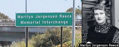 The I-405/I-10 Interchange (~ LA 29.484) is
named the "Marilyn Jorgenson Reece Memorial Interchange". It was
named in honor of Marilyn Jorgenson Reece, who was born and raised in
North Dakota and earned a bachelor's degree in civil engineering from the
University of Minnesota in 1948. Ms. Reece moved to Los Angeles with her
parents shortly after graduation in 1948, and went to work for the State
Division of Highways, which later became the Department of Transportation,
as a junior civil engineer in Los Angeles. After six years of experience
required to sit for the Professional Engineers Exam, Marilyn Jorgenson
Reece became the state's first fully licensed female civil engineer in
1954. In 1962, Marilyn Jorgenson Reece received the Governor's Design
Excellence Award from Governor Pat Brown for designing the I-10/I-405
interchange. Ms. Reece became the Division of Highway's first woman
resident engineer for construction projects shortly after receiving that
award. The three-level I-10/I-405 interchange designed by Marilyn
Jorgenson Reece opened in 1964 and was the first interchange designed in
California by a woman engineer. Urban critic Reyner Banham, author of
<I>Los Angeles: The Architecture of Four Ecologies</I>,
admired the wide-swinging curved ramps connecting the two freeways, and
wrote that the I-10/I-405 interchange "is a work of art, both as a pattern
on the map, as a monument against the sky, and as a kinetic experience as
one sweeps through it". During her 35-year career, Marilyn Jorgenson
Reece's projects included serving as senior engineer for the completion of
Route 210 through Sunland in 1975—at the time, the largest
construction project the Department of Transportation had ever
awarded—at $40 million. After retiring in 1983, Marilyn Jorgenson
Reece taught engineering classes at Cal State Long Beach; and during
Women's History Month in 1983, the Los Angeles City Council honored
Marilyn Jorgenson Reece for making significant contributions to the city.
In 1991, Marilyn Jorgenson Reece received life membership in the American
Society of Civil Engineers. Named by Senate Concurrent Resolution (SCR)
72, Resolution Chapter 96, on 8/15/2006.
The I-405/I-10 Interchange (~ LA 29.484) is
named the "Marilyn Jorgenson Reece Memorial Interchange". It was
named in honor of Marilyn Jorgenson Reece, who was born and raised in
North Dakota and earned a bachelor's degree in civil engineering from the
University of Minnesota in 1948. Ms. Reece moved to Los Angeles with her
parents shortly after graduation in 1948, and went to work for the State
Division of Highways, which later became the Department of Transportation,
as a junior civil engineer in Los Angeles. After six years of experience
required to sit for the Professional Engineers Exam, Marilyn Jorgenson
Reece became the state's first fully licensed female civil engineer in
1954. In 1962, Marilyn Jorgenson Reece received the Governor's Design
Excellence Award from Governor Pat Brown for designing the I-10/I-405
interchange. Ms. Reece became the Division of Highway's first woman
resident engineer for construction projects shortly after receiving that
award. The three-level I-10/I-405 interchange designed by Marilyn
Jorgenson Reece opened in 1964 and was the first interchange designed in
California by a woman engineer. Urban critic Reyner Banham, author of
<I>Los Angeles: The Architecture of Four Ecologies</I>,
admired the wide-swinging curved ramps connecting the two freeways, and
wrote that the I-10/I-405 interchange "is a work of art, both as a pattern
on the map, as a monument against the sky, and as a kinetic experience as
one sweeps through it". During her 35-year career, Marilyn Jorgenson
Reece's projects included serving as senior engineer for the completion of
Route 210 through Sunland in 1975—at the time, the largest
construction project the Department of Transportation had ever
awarded—at $40 million. After retiring in 1983, Marilyn Jorgenson
Reece taught engineering classes at Cal State Long Beach; and during
Women's History Month in 1983, the Los Angeles City Council honored
Marilyn Jorgenson Reece for making significant contributions to the city.
In 1991, Marilyn Jorgenson Reece received life membership in the American
Society of Civil Engineers. Named by Senate Concurrent Resolution (SCR)
72, Resolution Chapter 96, on 8/15/2006.
(Image source: PBWorks)
 Interstate Submissions
Approved as chargeable Interstate on 9/15/1955; Freeway. Originally, the California Department of Highways proposed this as I-9. In April 1958, they proposed it as I-3. They later suggested I-405, and that suggestion was accepted by AASHTO.
 Classified Landcaped Freeway
The following segments are designated as Classified Landscaped Freeway:
| County | Route | Starting PM | Ending PM |
| Orange | 405 | 0.00 | 1.09 |
| Orange | 405 | 3.69 | 6.19 |
| Orange | 405 | 7.58 | 7.79 |
| Orange | 405 | 8.40 | 12.41 |
| Orange | 405 | 12.50 | 24.18 |
| Los Angeles | 405 | 0.00 | 1.32 |
| Los Angeles | 405 | 1.50 | 7.41 |
| Los Angeles | 405 | 7.52 | 8.76 |
| Los Angeles | 405 | 8.91 | 9.78 |
| Los Angeles | 405 | 9.87 | 24.67 |
| Los Angeles | 405 | 24.73 | 28.60 |
| Los Angeles | 405 | 28.65 | 34.41 |
| Los Angeles | 405 | 37.01 | 48.03 |
 Freeway
[SHC 253.1] Entire route. Added to the Freeway and Expressway system in 1959.
 Exit Information
 Other WWW Links
 Statistics
Overall statistics for Route 405:
© 1996-2020 Daniel P. Faigin.
Maintained by: Daniel P. Faigin
<webmaster@cahighways.org>.
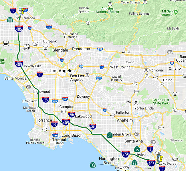 From Route
  Route 404
 Route 440
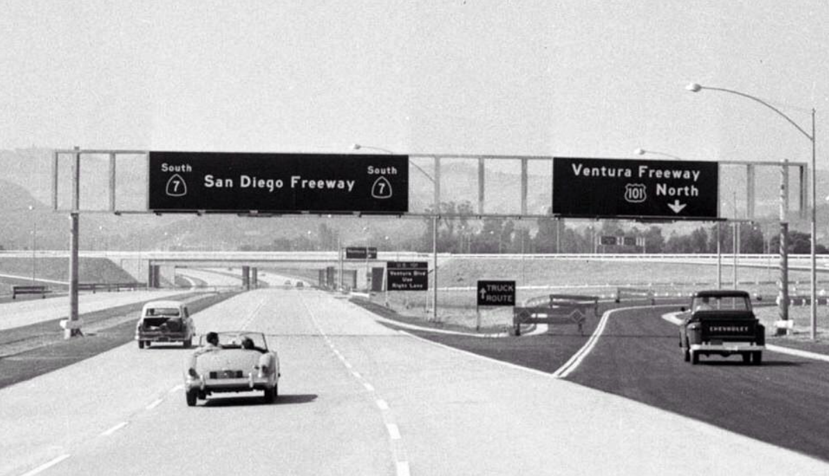