
 California Highways:
Click here for a key to the symbols used. An explanation of acronyms may be found at the bottom of the page.
 Routing
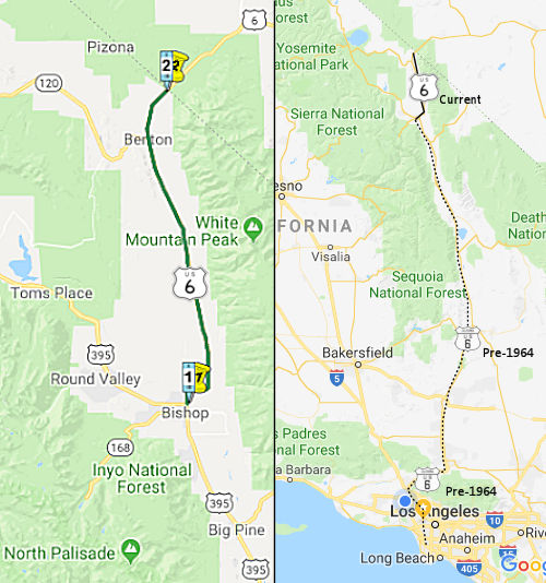 From Route 395 near Bishop to the Nevada state line near
Montgomery Pass.
From Route 395 near Bishop to the Nevada state line near
Montgomery Pass.
 Post 1964 Signage History
The definition of Route 6 is unchanged from the 1963 definition.
 Pre 1964 Signage History
  In 1934, State Signed Route 6 was defined to run from Santa
Monica to Jct. Route 39 near Fullerton. There were two portions: LRN 173,
which ran from LRN 60 in Santa Monica to the intersection of Ninth and
Indiana Streets in Los Angeles via Tenth Street; and LRN 166, which ran
from LRN 172, at the intersection of Indiana and Third Streets, in Los
Angeles, to LRN 171 near Santa Fe Springs. This routing corresponded to
the post-1938 Route 26 (LRN 173 / LRN 166). Once US 6 was established,
Sign Route 6 was renumbered as Sign Route 26, and then 1934 Sign Route 26
was dropped from the state highway system. This routing was along Pico
Blvd E from signed Route 3 (Lincoln) [later signed US 101A (LRN 60), now
Route 1], N on Robertson to Olympic, E on Olympic to Crenshaw, N on
Crenshaw, E on 10th Street and 9th Street, then E on Mines Ave near
Huntington Park, then SE along Anaheim-Telegraph Road to Santa Fe Springs,
then SE along Los Nietos Road, S on Valley View, SE on La Mirada Road to
Route 39.
In 1934, State Signed Route 6 was defined to run from Santa
Monica to Jct. Route 39 near Fullerton. There were two portions: LRN 173,
which ran from LRN 60 in Santa Monica to the intersection of Ninth and
Indiana Streets in Los Angeles via Tenth Street; and LRN 166, which ran
from LRN 172, at the intersection of Indiana and Third Streets, in Los
Angeles, to LRN 171 near Santa Fe Springs. This routing corresponded to
the post-1938 Route 26 (LRN 173 / LRN 166). Once US 6 was established,
Sign Route 6 was renumbered as Sign Route 26, and then 1934 Sign Route 26
was dropped from the state highway system. This routing was along Pico
Blvd E from signed Route 3 (Lincoln) [later signed US 101A (LRN 60), now
Route 1], N on Robertson to Olympic, E on Olympic to Crenshaw, N on
Crenshaw, E on 10th Street and 9th Street, then E on Mines Ave near
Huntington Park, then SE along Anaheim-Telegraph Road to Santa Fe Springs,
then SE along Los Nietos Road, S on Valley View, SE on La Mirada Road to
Route 39.
Prior to the definition and signage of US 6, the portion of the
route from Bishop to the California-Nevada state line was signed as part
of state Sign Route 168 along LRN 76. This was an eastern extension of
Route 168 from its present-day terminus in Bishop. LRN 76 in its entirety
was defined in 1931 and largely followed the path of the Carson &
Colorado Railway east of Bishop over the 7,100 foot Montgomery Pass to the
Nevada State Line. Route 168 east of the Sierras was cut back to US 395/US 6 in Bishop when the latter was extended into California in 1937. Route 168 would not be extended again until 1964 when it was routed east of US 395 to Oasis at Route 266.
 Before US 6 was truncated to end in Bishop, it consisted of the
following segments:
Before US 6 was truncated to end in Bishop, it consisted of the
following segments:
Note: Some maps show US 6 running along US 101 and Lankershim Blvd (LRN 159) (as demonstrated by the map on Michael Ballard's site, showing US 6 along Lankershim,
together with a short stub on the southern end of Route 170). However, it
does not appear that there was any signage in the field along Lakershim.
Construction on the extension of the Hollywood Freeway from the US 101/Route 134 North Hollywood interchange north to the Golden State (I-5)
freeway in the Arleta district of the San Fernando Valley began in late
1962; under the old numbering system, US 6 was to be rerouted off I-5/US 99 south of Arleta and down the new freeway, and multiplexing SE from N.
Hollywood with US 101 to the 4-Level Interchange in downtown L.A., and
picking up US 66 in Hollywood for a "triplex" NW of the 4-Level. In fact,
as the new "extension" was constructed, signage was placed for US 6 was
briefly placed on the southern end of future Route 170. It was planned to
temporarily route US 6 down Lankershim Blvd. (LRN 159, the existing route
to be replaced by the new freeway extension) to US 101 in the interim
while the rest of future Route 170 was constructed. The plans were to
place that signage in late 1963; however, those plans were put on hold
when it was decided in the spring of 1963 to renumber the entire system,
effective 1/1/64. Under those plans, US 6 was going to be truncated back
to Bishop under the new system, replacing signage for three or four months
was deemed pointless. In fact, US 6 was truncated out of the City of Los
Angeles when the first freeway segments of the Antelope Valley Freeway,
future Route 14, opened. But plans, showing the planned signage on
Lankershim were transmitted to the cartography departments of Gousha and
McNally; and Gousha included that signage in their 1963 editions.
(Source: Scott Parker on AAroads, 11/24/2017; Michael Ballard, email and website, 7/16/2020))
Colorado Street Extension (Route 5S)
The Colorado Street Freeway Extension (Route 5S) opened
in 1958 as the Golden State Freeway (then US 99, US 6 and I-5) was being
constructed. The Colorado Freeway Extension would serve as a
temporary realignment of US 99/US 6 off of San Fernando Road and new
alignment of Sign Route 134. US 99 and US 6 followed the Colorado
Street Freeway Extension to San Fernando Road until the Golden State
Freeway was completed to the San Bernardino Freeway in 1962. The
Colorado Street Freeway Extension would be assigned as part of the
original 1964 incarnation of Route 163, but was quickly folded into a
Route 134 Spur by 1965. The corridor would be assigned as part of
Route 5S when the Ventura Freeway extension reached Route 2 (then at
Verdugo Road) in 1969. Note: The Colorado
Street Extension is a formally suffixed route in the Postmile System
(Route 5S), as opposed to having "S" postmiles (i.e., 07-LA-005 S0.0).
(Source: Gribblenation Blog (Tom Fearer), "The Colorado Street Freeway Extension (Interstate 5 Spur in Glendale and Los Angeles)", 2/2024)
As originally defined, Colorado Street ended at San
Fernando Road (US 99 / LRN 4) in the city Glendale. Colorado Street
became a component of LRN 161 in 1933 after the state began to allow the
Division of Highways to maintain State Highways in incorporated
cities. When sign routes were announced in 1934, Sign Route 134 westbound followed a multiplex of US 99/LRN 4 on San Fernando Road
from the end of Colorado Street in Glendale to Alameda Avenue in Burbank.
US 99 along San Fernando Road would be joined by an extended US 6
beginning in 1937. In 1955, construction began on the Golden State Freeway
corridor between the Santa Ana Freeway and Hollywood Freeway; this would
be an eventual rerouting of US 99/US 6/LRN 4, and the route would take it
through the cities of Glendale and Burbank. By 1958, the Colorado
Boulevard Interchange was under construction to connect Sign Route 134 via
LRN 4 to US 99/US 6 on the Golden State Freeway over the Los Angeles River
extending it from San Fernando Road in Glendale. By 1959, the Golden State
Freeway was completed between Alameda Avenue in Burbank south to Glendale
Boulevard in Los Angeles. US 99/US 6 followed an interim alignment on LRN 4 originating at San Fernando Road in Burbank, west on Alameda Avenue,
south on the Golden State Freeway and east on the Colorado Street Freeway
Extension to San Fernando Road in Glendale. Route 134 followed an
interim multiplex of US 99/US 6/LRN 4 on the Golden State Freeway between
Colorado Street north to Alameda Avenue. South of Colorado Boulevard
to Glendale Street, the Golden State Freeway was part of LRN 161. The
completion of the Golden State Freeway from Lankershim Boulevard to the
Santa Ana Freeway in 1962 resulted in the realignment of US 99 to follow
I-5/LRN 4 on the Golden State Freeway directly to the San Bernardino
Freeway, bypassing the Pasadena Freeway and Santa Ana Freeway through
downtown Los Angeles. At this time, the Colorado Street Freeway
Extension was a spur of LRN 4 and solely signed as Route 134. This
segment became part of Route 163, only to go away in 1965 when it became a
spur of Route 134. With the completion of the Ventura Freeway Extension
from I-5 east to Route 2 at Verdugo Road in 1969, Route 134 was rerouted
off of Colorado Street in downtown Glendale north on Route 2/Verdugo Road
to the new segment of the Ventura Freeway. The Colorado Street
Freeway Extension was renumbered as Route 5S (note: it is not I-5S, as it
was never a formal part of the Interstate system)
(Source: Gribblenation Blog (Tom Fearer), "The Colorado Street Freeway Extension (Interstate 5 Spur in Glendale and Los Angeles)", 2/2024)
It also appears that an alternative routing for US 6 was proposed at the
time of its adoption in 1935. This alternative routing would have crossed
Tioga Pass and continued to San Francisco. A June 1935 sketch map from the
Division of Highways shows US 6 with two proposed alignments in
California. The first alignment shows US 6 entering California near
via then Route 168 near Benton. US 6 is shown terminating to the
south at Long Beach by way of Owens Valley and Los Angeles. The
Benton-Long Beach proposed alignment of US 6 was a violation of the
numbering conventions where even numbers denoted routes with a cardinal
east/west orientation. An alternative proposed alignment of US 6 to San
Francisco via Tioga Pass would have maintained the east/west
orientation. The Tioga Pass-San Francisco alignment of US 6 is shown
entering California via Route 168 to Benton, encompassing all of Route 120
west to Manteca, US 99W/LRN 66 to Lathrop, US 50/LRN 5 over Altamont Pass
to Hayward, LRN 105 from Hayward to the original 1929 San Mateo-Hayward
Bridge, west over San Francisco Bay via the 1929 San Mateo-Hayward Bridge
and north via multiplex of US 101/LRN 2 into downtown San Francisco.
The AASHTO Database does not provide an explanation as to why US 6 to San
Francisco via Tioga Pass passed over in favor of the proposed extension to
Long Beach. Only the proposal to extend US 6 to Long Beach appears
on the 1936 AASHO list of recommended additions to the US Route System. A
letter dated February 8th, 1937 by the AASHO Executive Secretary to the
State Highway Engineers of; Colorado, Nevada and California formally
announced the approved extension of US 6 from Greeley, Colorado to Long
Beach, California. The Merced Chamber of Commerce subsequently
requested the alternative route be added to US 6, requesting that the
proposed US 6A depart from Yosemite National Park via Route 140 via the
Yosemite-All Year Highway (completed between Mariposa and El Portal during
July 1926) which would have it pass through the City of Merced. The
Merced Chamber of Commerce proposal cited a continuation of US 6A westward
via Route 152 over Pacheco Pass and US 101 into San Francisco. The AASHO
Executive Secretary noted in respond in October 1937 that alternate US Routes were no longer being considered by the AASHO Executive Committee,
and the Merced Chamber of Commerce did not pursue the matter further
(however, AASHTO did go on to designate alternative US routes, notably US 101A in California).
(Source: Gribblenation Blog (Tom Fearer), “Paper Highways; US Route 6 to San Francisco via Tioga Pass”, 11/2021)
 Status
In June 2017, Michael Ballard reported that one of the bridges used by former US 6 (Sierra Highway) that crossed the Santa Clara River near Solemint, California, may be replaced in the near future. The bridge, constructed in 1938, is one of the oldest remaining in the Santa Clarita area and is the longest span on former US 6 in California. The bridge has remained almost intact from its original construction. The only changes have been minor to the bridge itself. The highway, however, has changed quite a bit. In 1968, Sierra Highway, then Route 14, was widened to four lanes. A second bridge for northbound traffic was added, with the original bridge being used for southbound traffic. The bridges were essentially bypassed when Route 14 was moved to the freeway alignment later. Presently, Sierra Highway is six lanes wide at the river crossing. As the bridges were built with a four-lane highway in mind, only a narrow shoulder along both directions exists. This condition is one of the reasons the bridges across the Santa Clara River are being replaced. Michael has a nice photo essay on his site (from which this text was stolen, with this credit, of course).
In October 2017, the CTC approved for future consideration of funding a
project that proposes to widen shoulders and add rumble strips on US 6,
near Bishop in Inyo and Mono counties (09-Iny-6, PM 4.3/8.4, 09-Mno-6, PM
0.0/0.8). This project is fully funded and programmed in the 2016 SHOPP
for $6.2 million which includes Construction (capital and support) and
Right-of-Way (capital and support). Construction is estimated to begin in
Fiscal Year 2017-18. The scope, as described for the preferred
alternative, is consistent with the project scope programmed by the
Commission in the 2016 SHOPP.
(Source: October 2017 CTC Agenda Item 2.2c.(1))
 Naming
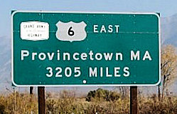 In 1937, it was proposed that US 6, from Provincetown
MA to Los Angeles CA be designed the Grand Army of the Republic
Highway. In 1943, the California Department of Transportation
adopted the name Grand Army of the Republic Highway for US 6.
According to CalTrans in March 1994, the Grand Army route is now US 6,
then US 395 to Route 14, Route 14 to I-5, I-5 to I-110, and then south to
San Pedro. A monument marking the western terminus of the Grand Army
Highway may be found on the wall on the S side of Ocean Avenue, in front
of the Terrace Theatre. It was named by Assembly Concurrent Resolution 33,
Chapter 73, in 1943.
In 1937, it was proposed that US 6, from Provincetown
MA to Los Angeles CA be designed the Grand Army of the Republic
Highway. In 1943, the California Department of Transportation
adopted the name Grand Army of the Republic Highway for US 6.
According to CalTrans in March 1994, the Grand Army route is now US 6,
then US 395 to Route 14, Route 14 to I-5, I-5 to I-110, and then south to
San Pedro. A monument marking the western terminus of the Grand Army
Highway may be found on the wall on the S side of Ocean Avenue, in front
of the Terrace Theatre. It was named by Assembly Concurrent Resolution 33,
Chapter 73, in 1943.
(Image Source: Clamshack on Flikr)
One map from 1938 shows US 6 as being named the "Roosevelt" Highway.
 Historical Route
ACR 26 requested the Department of Transportation, upon application by an interested local agency or private entity, to identify any section of former U.S. Highway Route 6 that is still a publicly maintained highway and that is of interest to the applicant, and to designate that section as Historic U.S. Highway Route 6. Chaptered July 3, 2007. Resolution Chapter 67.
 Other WWW Links
 Freeway
[SHC 253.1] Entire route. Added to the Freeway and Expressway system in 1959. Note that although the route is legislatively designated as freeway, it is not constructed to freeway standards (i.e., there are grade crossings).
 Statistics
Overall statistics for Route 6:
 National Trails
 The portions of this route corresponding to present day Route 14 were part of the Midland Trail. The portions of this route cosigned with US 99 were
part of the National Parks to Parks Highway.
The portions of this route corresponding to present day Route 14 were part of the Midland Trail. The portions of this route cosigned with US 99 were
part of the National Parks to Parks Highway.
 Interregional Route
[SHC 164.10] Entire route.
 Pre-1964 Legislative Route
The routing that would become LRN 6 was defined in the 1909 First Highway Bonds, running from Sacramento to Woodland Junction. It was extended in 1933 to run from [LRN 8] near Napa to Winters via Wooden Valley and Berryessa Valley. By 1935, the routing had been codified as being:
Only the first segment was considered a primary route.
In 1939, Chapter 473 changed the reference to "Woodland Junction" to [LRN 7]. In 1957, Chapter 36 filled the gap between the two segments, changing the second segment to read "[LRN 8] near Napa to [LRN 90] near Winters". In 1959, Chapter 1062 added the north bypass of Napa, changing the second segment again to “[LRN 49] near Napa to [LRN 7] near Davis”.
Signage on the route was as follows:
This segment was signed as US 99W/US 40, and had a routing that approximates the current I-80. Starting at 15th and N St. in Sacramento, it ran out of the city on N Street. It continued W until reaching the US 40/Alt. US 40 junction (approximately the present-day I-80/Route 113 junction) SW of Davis. This 15 mi segment was defined in 1909. The portion between present-day Route 160 and I-80 is signed as Business Route 80, and is real Route 50. Part of this is Route 275.
According to a CTC vacation resolution in January 2005, Capitol Mall (formerly LRN 6, which was signposted as US 40) was the principal route for traffic traveling between Sacramento and San Francisco resulting in high volumes of inter-regional and local traffic using the same corridor. Upon completion of the freeway system in Sacramento, inter-regional traffic on Capitol Mall was almost completely eliminated.
This segment was signed as Route 128 (and is still signed that way) from present-day I-505 W of Davis to the junction with pre-1964 Route 37 (present-day Route 121). This segment was added in 1933.
LRN 6 was extended on paper between Route 505 and Route 113 in 1959.
LRN 6 continued S signed as Route 37 (present-day Route 121) to Napa, until it reached the junction with LRN 49 (the present Route 12/Route 29/Route 121 junction). This portion was also defined in 1933.
© 1996-2020 Daniel P. Faigin.
Maintained by: Daniel P. Faigin
<webmaster@cahighways.org>.
 Route 5
 Route 7