
 California Highways:
Click here for a key to the symbols used. An explanation of acronyms may be found at the bottom of the page.
 Routing
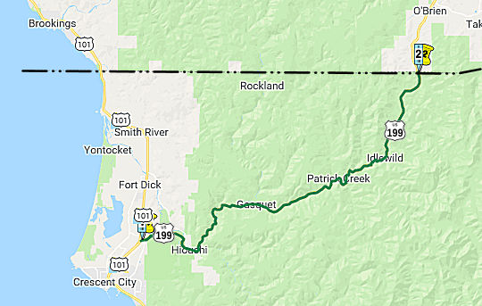 From Route 101 near Crescent City to the Oregon state line via the Smith River.
 Post 1964 Signage History
This route remains unchanged from its 1963 definition.
 Pre 1964 Signage History
This route was part of the original set of planned routes in 1926, as was signed as US 199 in 1928 (although one report gives 1932). It is part of LRN 1, defined in 1919.
According to Tom Fearer, the history of what became US 199 begins in the
1854 when the City of Crescent City incorporated. The incorporation
of Crescent City drove the need for a Stage Route to be built inland to
Oregon. In June of 1854 the Crescent City & Yreka Plank Turnpike
Company (CCYPTC) formed with the goal of building a wagon road through the
Klamath Mountains to Oregon via Oregon Mountain. To that the CCYPTC
surveyed a route to Oregon by October of 1854 but no work began as a
recession hit during 1855. The CCYPTC began construction of a
planked wagon road in 1857 and completed it during May of 1858. Upon
reaching Oregon Mountain the CCYPTC wagon road turned east straddling the
State Line via Wilmer Road before turning north towards via what is now
Lone Mountain Road. The CCYPTC wagon road followed modern US 199
through O'Brien, Waldo, Kerby, and Wilderville. From Wilderville the
CCYPTC route turned east via what is now Fish Hatchery Road, the Applegate
River, and OR 238 towards the mining City of Jacksonville. In 1881 the
Gasquet Toll Road began to be constructed to Oregon Mountain where it
crossed the Oregon State Line and met the existing CCYPTC plank
road. The Gasquet Toll Road was a log surface design and would be
completed by 1887. The Gasquet Toll Road was connected from Gasquet
to Crescent City via the Smith River, Mill Creek, and Howland
Summit. The general path of the Gasquet Toll Road included a new
suspension bridge at the confluence of the Smith River and South Fork
Smith River. The future route of US 199 was added to the Oregon State
Route System during 1917 when it was added as Oregon Highway 25 between
Grants Pass southwest to the California State Line. As noted above,
the future route of US 199 in California was added to the State Highway
System during the 1919 Third State Highway Bond Act, when what was to be
LRN 1 was extended to the Oregon State line. The route was aligned over
the Gasquet Toll Road, added as part of a 1919 Legislative Amendment.
(Source: Gribblenation Blog (Tom Fearer): "US Route 199")
In 1925, as part of the Smith River Forest Project, LRN 1 was realigned
onto the new Redwood Highway. This highway was cited to be an
average of 22 feet wide and is stated to be a direct replacement for the
Gasquet Toll Road, and was schedule to open in the summer of 1926. By
1935, the alignment of US 199 departed US 101 in Crescent City via Parkway
Drive. By 1956, US 101 had been moved off of Northcrest Drive in Crescent
City and onto Parkway Drive. US 199's western terminus was moved a
couple miles eastward on Parkway Drive near what is now Cookie Street.
Former US 101 on Northcrest Drive would later become Del Norte County Sign Route D2 by
1966. The groundbreaking ceremony for what was called the "Hazelview
Tunnel" is discussed in the September/October 1960 CHPW guide. In the
November/December 1963 CHPW article the now named "Randolph Collier
Tunnel" on US 199 through Oregon Mountain is stated to have opened on July
27th.
(Source: Gribblenation Blog (Tom Fearer): "US Route 199")
 Status
US 101 / US 199 Freeway
 In July 1970, it was reported that studies were ongoing for a planned freeway
interconnection between US 101 and US 199 between Elk Valley Cross Road
and 3.3 mi W of Myrtle Creek, which includes the Jedediah Smith Redwoods
State Park. On 10/4/1963, the Division of Highways held a hearing on the
portions of US 101 and US 199 between 0.3 mi N of Northcrest Drive and 1.4
mi S of the Gasquet Post Office. On 12/18/1963, adopted a freeway routing
for this section -- what is shown as the blue line. Then, on 11/17/1965,
the CHC decided to study alternate routes. This resulted in three
alternatives presented on 1/14/1970. Two of these, the Orange and Brown,
bypassed the park completely. The third, the Green, crossed two narrow
northerly extensions of the park. The Sierra Club also made a proposal,
which was called the Modified Orange. There was also a refinement to that
proposal, called the Orange Black.
In July 1970, it was reported that studies were ongoing for a planned freeway
interconnection between US 101 and US 199 between Elk Valley Cross Road
and 3.3 mi W of Myrtle Creek, which includes the Jedediah Smith Redwoods
State Park. On 10/4/1963, the Division of Highways held a hearing on the
portions of US 101 and US 199 between 0.3 mi N of Northcrest Drive and 1.4
mi S of the Gasquet Post Office. On 12/18/1963, adopted a freeway routing
for this section -- what is shown as the blue line. Then, on 11/17/1965,
the CHC decided to study alternate routes. This resulted in three
alternatives presented on 1/14/1970. Two of these, the Orange and Brown,
bypassed the park completely. The third, the Green, crossed two narrow
northerly extensions of the park. The Sierra Club also made a proposal,
which was called the Modified Orange. There was also a refinement to that
proposal, called the Orange Black.
(Source: Eureka Times-Standard, 7/7/1970 via Joel Windmiller,
1/27/2023)
Based on the 2023 map, it appears the freeway proposal died; hence, the potential alternates are not described in detail.
A planned expressway (or freeway) alignment for US 199 appears in Compass's Redwood Coast map; this would begin 2 miles north of the current US 101/US 199 interchange, approximately at the intersection of US 101 and Arrowhead Drive, and continue on a meandering path east towards Route 197 at Low Divide Road. (It is unclear what will happen to the southernmost segment of Route 197 between the proposed routing and Route 199 should Route 199 be assigned to this new alignment.) This plan appears to be designed to avoid the Jedediah Smith Redwoods State Park altogether (current US 199 cuts through the park). This planned alignment seems to correspond with the Orange Line of the Freeway Proposal. Evidently, the inclusion on the map was anticipatory thinking.
In January 2016, the CTC authorized SHOPP funding in Del Norte County, on Route 101 at Railroad Avenue Overcrossing No. 01-0063, Smith River Overflow Bridge No. 01-0046, Rowdy Creek Bridge No. 01-0023; also on Route 199, at Route 199/101 Connector Overcrossing No. 01-0058F (DN 0.000). Outcome/Output: Install seismic retrofit measures on four bridges to maintain bridge structural integrity. $1,650,000.
Elk Valley Cross Road Roundabout (01-DN-199 T0.8)
In March 2023, the CTC approved the following amendment
into the 2022 SHOPP: 01-DN-199 T0.8. PPNO 01-1154; ProjID 0122000073; EA
0L990. US 199 Near Crescent City, at Elk Valley Cross Road. Construct
roundabout. Allocation ($ × 1,000): PA&ED $710; PS&E $922;
R/W Sup $211; Con Sup $2,125; R/W Cap $23; Const Cap $3,969; TOTAL $7,960.
Begin Const: 1/27/2026. Concurrent COS allocation under Resolution
FP-22-57; March 2023.
(Source: March 2023 CTC Agenda, Agenda Item 2.1a.(1a) #33)
In March 2023, the CTC approved the following
pre-construction project support phase SHOPP (2a) or SB1 (2b) allocation:
$710,000. 01-DN-199 T0.8. PPNO 01-1154; ProjID 0122000073; EA 0L990.
US 199 Near Crescent City, at Elk Valley Cross Road. Construct roundabout.
Concurrent Amendment under SHOPP Amendment 22H-007; March 2023. PA&ED
$710,000 FY25-26.
(Source: March 2023 CTC Agenda, Agenda Item 2.5b.(2a) #1)
In December 2023, the CTC approved the following
amendment to a project in the 2022 SHOPP: 01-DN-199 T0.8. PPNO 01-1154;
ProjID 0122000073; EA 0L990. US 199 Near Crescent City, at Elk Valley
Cross Road. Construct roundabout. Note: Increase construction
capital to change the roundabout pavement strategy from asphalt to
concrete to lower maintenance needs and improve worker safety. The
additional safety needs will be funded through Infrastructure Investment
and Jobs Act (IIJA) funds. Additional construction capital is also needed
due to increased unit prices and quantities. Update performance to match
the current Department methodology. Allocation Changes ($ × $1000):
Const Cap $3,969 $7,094; TOTAL $7,960
$11,085.
(Source: December 2023 CTC Agenda, Agenda Item 2.1a.(1d) #1)
In June 2016, the CTC approved for future consideration of funding a project in Del Norte County near the Smith River (01-DN-199, PM 8.0/8.5) that will realign curves, widen lanes and shoulders, construct a viaduct and bridge, and make other improvements on US 199 near Crescent City. The project is programmed in the 2014 State Highway Operation and Protection Program. The total programmed amount is $7,763,000 for capital and support. Construction is estimated to begin in Fiscal Year 2016-17. The scope, as described for the preferred alternative, is consistent with the project scope programmed by the Commission in the 2014 State Highway Operation and Protection Program. A copy of the ND has been provided to Commission staff. The project will result in less than significant impacts to the environment.
In June 2016, the CTC approved $3,268,000 for a project on US 199 near Hiouchi, at 1.0 mile north of South Fork Road (~ DN 8.19). Outcome/Output: Widen roadway and shoulders to make standard. Install rumble strips and high friction surface treatment and other curve improvements to reduce the number and severity of collisions. Concurrent Consideration of Funding under Resolution E-16-33; June 2016
In December 2018, it was reported that the CTC allocated $600,000 of
support costs for the advancement of a project on US 199 in Del Norte
County from 0.7 to 0.3 miles south of the Hardscrabble Creek Bridge
(Bridge 01-0040, DN 011.01). The proposed project includes the
installation of a High Friction Surface Treatment, signs, guardrail, and a
centerline rumble strip. The CTC Minutes show the following allocation for
this: 01-DN-199 PM 10.2/10.7 PPNO 1121. Project No. 0116000128. Route 199
Near Gasquet, from 0.7 to 0.3 mile south of Hardscrabble Creek Bridge.
Install High Friction Surface Treatment (HFST), signs, guardrail, and
centerline rumble strip.
(Source: Redheaded Blackbelt, 12/10/2018; December2018
CTC Minutes, Agenda Item 2.5b(2a) Item 1)
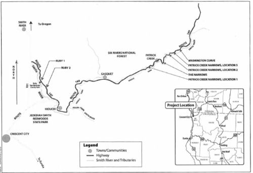
197/199 Safe STAA Access Project (01-DN-197, PM 3.2/4.5; 01-DN-199, PM 20.5/26.5; PPNO 01-1161)
 In December 2012, the CTC reviewed a draft EIR related to
improvements on Route 197 and US 199 and had no comments. The project will
improve spot locations on Route 197 and US 199 in Del Norte County so that
two Surface Transportation Assistance Act (STAA) trucks passing in
opposite directions can be accommodated. Within the project limits, Route 197 and US 199 are rugged, two-lane conventional highways with tight
curves and steep-cut slopes providing narrow traffic lanes with narrow
shoulders (if shoulders exist). Route 197 is the designated route for the
movement of extralegal truck loads between US 101 and US 199 because it
avoids traversing Jedediah Smith Redwoods Park. Known as North Bank Road,
Route 197 was built in the 1930s. US 199 in the project limits traverses
the Middle Fork Smith River and was built in the early 1920s and is a
tightly curved alignment with spectacular views. The proposed work
consists of roadway widening, shoulder widening, roadway curve
improvements, bridge replacements and culvert replacements. The project
will bring Route 197 and US 199 into compliance with federal and state
legislations regarding access for STAA trucks. It is split into four
projects: Ruby 1 (EA 48110, Route 197 PM 4.5) is fully funded in
the SHOPP Minor A Program. It would lengthen the curve and increase
shoulder width. Culverts and drainage would be adjusted. The total
estimated cost is $2,499,000. Construction is estimated to begin in Fiscal
Year 2013-14. Ruby 2 (EA 45490, Route 197, PM 3.2 to 4.0) is fully
funded in the SHOPP Minor A Program. This would improve the existing road
curve, roadbed elevation, and roadway width. Different alternatives have
slightly different roadway and shoulder widths. The total estimated cost
is $3,400,000. Construction is estimated to begin in Fiscal Year 2014-15.
Patrick Creek Narrows (PPNO 1047) will improve US 199 from Post
Mile 20.5 to 20.7, Post Mile 23.9 to 24.3, and Post Mile 25.55 to 25.65.
Most of these involve improving curves and slight roadway widening. It
would also replace the existing Middle Fork Smith River bridge with either
an upstream or downstream alternative, or rework the existing bridge to
allow large trucks to cross. The project is programmed in the 2012 STIP.
The total estimated cost for capital and support is $21,302,000.
Construction is estimated to begin in Fiscal Year 2012-13. The Narrows
and Washington Curve (PPNO 1073) will improve US 199 from Post Mile
22.7 to 23.0 (Narrows), and from PM 26.3 to 26.5 (Washington Curve). These
involve lane widening and curve improvement. The project is programmed in
the 2012 SHOPP. The total estimated cost for capital and support is
$6,750,000. Construction is estimated to begin in Fiscal Year 2015-16. For
these four projects, there are a total 12 build alternatives being
proposed as well as the no build alternative
In December 2012, the CTC reviewed a draft EIR related to
improvements on Route 197 and US 199 and had no comments. The project will
improve spot locations on Route 197 and US 199 in Del Norte County so that
two Surface Transportation Assistance Act (STAA) trucks passing in
opposite directions can be accommodated. Within the project limits, Route 197 and US 199 are rugged, two-lane conventional highways with tight
curves and steep-cut slopes providing narrow traffic lanes with narrow
shoulders (if shoulders exist). Route 197 is the designated route for the
movement of extralegal truck loads between US 101 and US 199 because it
avoids traversing Jedediah Smith Redwoods Park. Known as North Bank Road,
Route 197 was built in the 1930s. US 199 in the project limits traverses
the Middle Fork Smith River and was built in the early 1920s and is a
tightly curved alignment with spectacular views. The proposed work
consists of roadway widening, shoulder widening, roadway curve
improvements, bridge replacements and culvert replacements. The project
will bring Route 197 and US 199 into compliance with federal and state
legislations regarding access for STAA trucks. It is split into four
projects: Ruby 1 (EA 48110, Route 197 PM 4.5) is fully funded in
the SHOPP Minor A Program. It would lengthen the curve and increase
shoulder width. Culverts and drainage would be adjusted. The total
estimated cost is $2,499,000. Construction is estimated to begin in Fiscal
Year 2013-14. Ruby 2 (EA 45490, Route 197, PM 3.2 to 4.0) is fully
funded in the SHOPP Minor A Program. This would improve the existing road
curve, roadbed elevation, and roadway width. Different alternatives have
slightly different roadway and shoulder widths. The total estimated cost
is $3,400,000. Construction is estimated to begin in Fiscal Year 2014-15.
Patrick Creek Narrows (PPNO 1047) will improve US 199 from Post
Mile 20.5 to 20.7, Post Mile 23.9 to 24.3, and Post Mile 25.55 to 25.65.
Most of these involve improving curves and slight roadway widening. It
would also replace the existing Middle Fork Smith River bridge with either
an upstream or downstream alternative, or rework the existing bridge to
allow large trucks to cross. The project is programmed in the 2012 STIP.
The total estimated cost for capital and support is $21,302,000.
Construction is estimated to begin in Fiscal Year 2012-13. The Narrows
and Washington Curve (PPNO 1073) will improve US 199 from Post Mile
22.7 to 23.0 (Narrows), and from PM 26.3 to 26.5 (Washington Curve). These
involve lane widening and curve improvement. The project is programmed in
the 2012 SHOPP. The total estimated cost for capital and support is
$6,750,000. Construction is estimated to begin in Fiscal Year 2015-16. For
these four projects, there are a total 12 build alternatives being
proposed as well as the no build alternative
In June 2013, the CTC accepted the environmental document for Ruby 1, Ruby 2, Patrick Creek Narrows, and Narrows and Washington Curve.
In September 2020, it was reported that the Crescent
City Harbor District added support to the Del Norte Local Transportation
Commission for a project to bring Route 199 and Route 197 up to 1982
trucking standards. Harbor commissioners unanimously approved a resolution
reaffirming their support for the project, which has been stalled when
Friends of Del Norte, the Environmental Protection Information Center and
the Center For Biological Diversity obtained an injunction in 2014. The
Harbor District’s vote comes about two weeks after a federal judge
in the case awarded intervenor status to the Del Norte Local
Transportation Commission. According to a staff report, the Local
Transportation Commission argued that it is local elected officials, not
the litigants, who represent the public. The Del Norte Unified School
District Board of Trustees has also unanimously declared their support for
the STAA 197/199 project, stating that widening the road is also essential
for school buses. The $34 million project includes widening three curves
on US 199 and replacing a bridge that was built in 1924. It also consists
of widening two curves on Route 197 near Ruby Van Deventer County Park.
Caltrans’ goal is to make the project safer for trucks meeting the
1982 Surface Transportation Assistance Act (STAA) standard. The project
has been paid for with state and federal dollars since 2008 and was about
to enter the construction phase when Friends of Del Norte, EPIC and Center
For Biological Diversity initiated a lawsuit that stalled the project in
2014. The three conservation groups argued that allowing for the larger
STAA trucks would increase, rather than decrease the risk to safety on the
two roads. The three groups are also concerned about the possibility of a
hazardous material spill impacting the Smith River. However, restricting
the travel of trucks carrying hazardous materials down US 199 and Route 197 could circumvent that argument.
(Source: Wild Rivers Outpost, 9/1/2020)
 In March 2022, it was reported that a federal judge had lifted the injunction
that prevented Caltrans from completing road improvements on two highways
which, at many points, run directly alongside the wild Smith River.
Specifically, U.S. District Judge James Donato lifted the nearly
decadelong injunction after finding Caltrans’ revised plans for
improvements on US 199 and Route 197 did not violate the Magnuson-Stevens
Fishery Conservation and Management Act. Plaintiffs Friends of Del Norte,
an environmental group based in the state northwesternmost county, sued
Caltrans claiming plans for improving the highways posed a threat to the
salmon that inhabit the 25-mile river. The project had been intended to
facilitate the movement of large trucks. But in 2014 the judge found
"serious questions about the adequacy of the reviews and consultation
process that Caltrans and National Marine Fisheries Service conducted
under the Endangered Species Act.” At the time, the court found
“contradictions and critical gaps in reasoning” in the two
agencies’ assessments of the project's effects, and even whether a
formal consultation was required under the Endangered Species Act. Two
species of endangered salmon, coho and Chinook, inhabit the river along
with cutthroat and steelhead trout, according to the U.S. Geological
Survey. Rather than appealing, Caltrans launched a second round of
consultations with the Fisheries Service, which resulted in a revised
evaluation of the project’s potential effects.
In March 2022, it was reported that a federal judge had lifted the injunction
that prevented Caltrans from completing road improvements on two highways
which, at many points, run directly alongside the wild Smith River.
Specifically, U.S. District Judge James Donato lifted the nearly
decadelong injunction after finding Caltrans’ revised plans for
improvements on US 199 and Route 197 did not violate the Magnuson-Stevens
Fishery Conservation and Management Act. Plaintiffs Friends of Del Norte,
an environmental group based in the state northwesternmost county, sued
Caltrans claiming plans for improving the highways posed a threat to the
salmon that inhabit the 25-mile river. The project had been intended to
facilitate the movement of large trucks. But in 2014 the judge found
"serious questions about the adequacy of the reviews and consultation
process that Caltrans and National Marine Fisheries Service conducted
under the Endangered Species Act.” At the time, the court found
“contradictions and critical gaps in reasoning” in the two
agencies’ assessments of the project's effects, and even whether a
formal consultation was required under the Endangered Species Act. Two
species of endangered salmon, coho and Chinook, inhabit the river along
with cutthroat and steelhead trout, according to the U.S. Geological
Survey. Rather than appealing, Caltrans launched a second round of
consultations with the Fisheries Service, which resulted in a revised
evaluation of the project’s potential effects.
(Source: Missoula Current, 3/4/2023)
In December 2023, the CTC approved for future
consideration of funding the following project for which a Final
Environmental Impact Report (FEIR) and Addenda have been completed: 197/199
Safe STAA Access Project. Route 197 and US 199 in Del Norte
County. Construct improvements at spot locations on Route 197 and US 199
to reclassify the routes as part of the Federal Surface Transportation
Assistance Act (STAA) truck route network and to comply with federal and
state legislation and regional programs, plans, and policies to allow STAA
access. The project involves curve adjustment and widening lanes and
shoulders, in Del Norte County. (01-DN-197, PM 3.2/4.5; 01-DN-199, PM
20.5/26.5; PPNO 01-1161) The project is located on Route 197 from PM
3.2 to PM 4.5, in Del Norte County. The Department proposes to construct
improvements at spot locations on Route 197 and US 199 to reclassify the
routes as part of the Federal Surface Transportation Assistance Act (STAA)
truck route network and to comply with federal and state legislation and
regional programs, plans, and policies to allow STAA access. The project
involves curve adjustment and widening lanes and shoulders. The project is
currently programmed in the 2022 State Highway Operation and Protection
Program (SHOPP). The total programmed amount, which includes Right of Way
(Support and Capital), and Construction (Support and Capital) is
$60,000,000. Construction is estimated to begin in 2028-29. The scope, as
described for the preferred alternative, is consistent with the project
scope as programmed by the Commission in the 2022 SHOPP. A copy of the
FEIR has been provided to Commission staff. The Commission approved the
project for future consideration of funding on June 11, 2013, under
Resolution E-13-46. Since the approval of the FEIR, there have been
changes to the project and Addenda were prepared pursuant to the
California Environmental Quality Act (CEQA). The first Addendum was
prepared on January 31, 2013, after culvert drainage work was determined
not to impact jurisdictional waters of the U.S. or waters of the State,
and therefore would not require a 1600, 401, or 404 permit. The second
addendum was prepared on August 17, 2017, because of a lawsuit, and the
project was put under an injunction in May 2014. Accordingly, in May 2014,
the Department began the process of re-initiation of Endangered Species
Act and Magnuson- Stevens Fishery Conservation and Management Act
consultation with the National Marine Fisheries Service by preparing a new
Biological Assessment (BA). The Department submitted a new BA on March 30,
2017, and received a Letter of Concurrence on June 28, 2017, as described
in the Addenda. The project changes do not meet the criteria outlined in
CEQA Guidelines Section 15162 and Section 15163 to prepare a Subsequent or
Supplemental FEIR. The Department subsequently completed Addenda to the
FEIR pursuant to CEQA. The Department has approved this project for
construction. This approval and the Addenda will satisfy the environmental
requirements for this stage of the planning process.
(Source: December 2023 CTC Agenda, Agenda Item 2.2c.(2))
In December 2023, the CTC approved the following SHOPP
preconstruction-phase allocation:. $4,420,000. 01-DN-197 M3.2/4.5. PPNO
01-1161; ProjID 0123000202; EA 0N290. Route 197 Near Crescent City, from
Kaspar/Keene Road to Ruby Van Deventer County Park; also on US 199, from
0.7 mile north of Patrick Creek Bridge to 1.1 mile north of Siskiyou Fork
Road (PM 22.7/26.5). Improve cross slope, widen roadway, improve drainage,
replace guardrail, install rockfall wire mesh, and construct retaining
walls. Future consideration of funding approved under Resolution E-13-46;
June 2013. Concurrent addendum for the previously approved Future
Consideration of Funding under Resolution E-23-156A; December 2023.
Programmed (Allocation, if different): PS&E
$4,348,000; R/W Sup $72,000.
(Source: December 2023 CTC Agenda, Agenda Item 2.5b.(2) #1)
Middle Fork Smith River Bridge Curve Improvement (01-DN-199 24.1/24.3)
At the June 2021 CTC meeting, the CTC amended the
following project into the 2020 SHOPP: 01-DN-199 24.1/24.3 PPNO 1141
ProjID 0120000129 EA 01-0K640. US 199 Near Gasquet, from Middle Fork Smith
River Bridge to 0.2 mile north of Middle Fork Smith River Bridge. Curve
improvement. PA&ED $1,325K; PS&E $1,054K; R/W Sup $16K; Con Sup
$594K; R/W Cap $3K; Const Cap $1,577K TOTAL $4,569K. Begin Const:
3/19/2024. It also approved the following allocation: (2a) #1. 01-DN-199
24 1/24 3. PPNO 1141; ProjID 0120000129; EA 0K640. Route 199 Near Gasquet,
from Middle Fork Smith River Bridge to 0.2 mile north of Middle Fork Smith
River Bridge. Curve improvement. (Concurrent amendment under SHOPP
Amendment 20H-008; June 2021.). Allocation: PA&ED $1,325,000
(FY23-24).
(Source: June 2021 CTC Minutes, Agenda Item
2.1a.(1a) #6; June 2021 CTC Minutes, Agenda Item 2.5b.(2a) #1)
In March 2023, the CTC approved the following
pre-construction project support phase SHOPP (2a) or SB1 (2b) allocation:
$1,070,000. 01-DN-199 24.1/24.3. PPNO 01-1141; ProjID 0120000129; EA
0K640. US 199 Near Gasquet, from Middle Fork Smith River Bridge to 0.2
mile north of Middle Fork Smith River Bridge. Curve improvement. PS&E
$1,054,000; R/W Sup $16,000.
(Source: March 2023 CTC Agenda, Agenda Item 2.5b.(2a) #2)
Location Unspecified
The SAFETEA-LU act, enacted in August 2005 as the reauthorization of TEA-21, provided the following expenditures on or near this route:
 Naming
 This route is named the "Redwood Highway".
(Image source: AARoads)
 This route was part of the "Winnemucca to the Sea Highway". This route was developed to
establish a continuous, improved all-weather highway from US-40 (I-80) at
Winnemucca, Nevada through Medford, Oregon and on to the Pacific coast at
Crescent City, California. The Winnemucca to the Sea Highway Association
proposed this as US 140, but the number was never assigned. Instead,
it is represented by a combination of route numbers: US 95, Nevada
140 (originally Nevada 8A), Oregon 140, US 395, Oregon 62, I-5, US 199,
and US 101. Winnemucca, named after a local Paiute chief, began as a
bridge over the Humboldt River for emigrants taking the Applegate-Lassen
trail into northern California and Oregon, and was a major point on the
transcontinental railroad and is a stop over on the ocean-to-ocean highway
US-40 (I-80).
This route was part of the "Winnemucca to the Sea Highway". This route was developed to
establish a continuous, improved all-weather highway from US-40 (I-80) at
Winnemucca, Nevada through Medford, Oregon and on to the Pacific coast at
Crescent City, California. The Winnemucca to the Sea Highway Association
proposed this as US 140, but the number was never assigned. Instead,
it is represented by a combination of route numbers: US 95, Nevada
140 (originally Nevada 8A), Oregon 140, US 395, Oregon 62, I-5, US 199,
and US 101. Winnemucca, named after a local Paiute chief, began as a
bridge over the Humboldt River for emigrants taking the Applegate-Lassen
trail into northern California and Oregon, and was a major point on the
transcontinental railroad and is a stop over on the ocean-to-ocean highway
US-40 (I-80).
(Source: article by John Ryczkowski; Image source:
Looking for Detachment)
 Named Structures
 Meedom Memorial Bridge") The Hardscrabble Bridge, located on Route 199 six miles east of Hiouchi Village (Bridge 01-0040, DN
011.01) in Del Norte County, is officially named the "Viggo "Vic"
Meedom Memorial Bridge". Viggo "Vic" Meedom was born in Denmark, and
died in October of 1995 at the age of 101. He served Del Norte County as a
member of the Crescent City Council, a member of the Del Norte County
Board of Supervisors, and an original member of the Del Norte County Local
Hospital District Board of Directors. Named by Senate Concurrent
Resolution No. 55, Chapter 22, in 1996. The plaque reads: "A native of
Denmark, "Vic" immigrated to the U.S. in 1913 and arrived in California in
1915. He was a WWII veteran and became a U.S. citizen in 1922. "Vic" came
to Del Norte County in 1935. He was active in state and local government
as a citizen and public servant. From 1943 to 1952 he served on the Knapp
and Seaside Hospital District Boards. He was a Crescent City Councilman
from 1946 to 1948 and served as a Del Norte County Supervisor from 1949 to
1953. "Vic" was appointed by Governor Warren in 1947 to the first
California Advisory Health Care Council and served until 1974." Meedom
died on 20 Oct 1995 at the age of 101.
The Hardscrabble Bridge, located on Route 199 six miles east of Hiouchi Village (Bridge 01-0040, DN
011.01) in Del Norte County, is officially named the "Viggo "Vic"
Meedom Memorial Bridge". Viggo "Vic" Meedom was born in Denmark, and
died in October of 1995 at the age of 101. He served Del Norte County as a
member of the Crescent City Council, a member of the Del Norte County
Board of Supervisors, and an original member of the Del Norte County Local
Hospital District Board of Directors. Named by Senate Concurrent
Resolution No. 55, Chapter 22, in 1996. The plaque reads: "A native of
Denmark, "Vic" immigrated to the U.S. in 1913 and arrived in California in
1915. He was a WWII veteran and became a U.S. citizen in 1922. "Vic" came
to Del Norte County in 1935. He was active in state and local government
as a citizen and public servant. From 1943 to 1952 he served on the Knapp
and Seaside Hospital District Boards. He was a Crescent City Councilman
from 1946 to 1948 and served as a Del Norte County Supervisor from 1949 to
1953. "Vic" was appointed by Governor Warren in 1947 to the first
California Advisory Health Care Council and served until 1974." Meedom
died on 20 Oct 1995 at the age of 101.
(Image source; Bridgehunter; Find a Grave)
 Bridge 01-0009 (DN R011.95) over the Smith River, 12 mi E of Crescent City in Del Norte
county, is named the "Mary Adams Peacock Memorial Bridge". It was
built in 1926 and rebuilt in 1985, and was named in 1932. Del Norte County
pioneer school teacher, Mary Adams Peacock (1861-1946), established
"Adams' Station" in 1898 and married stage drive Peter Peacock in 1908.
Two native plants, Anemone Adamsiana and Valeriana Adamsiana, are named
for "Aunt Mary Adams". Mary Adams was born at Waldo, Ore., in 1861.
When she grew up, she moved to Grants Pass to start a dressmaking business
while working as a housekeeper to make ends meet. Six years later, Adams
changed direction and decided to run a string of pack mules and contract
to carry mail from Crescent City to Grants Pass. She became an exceptional
muleskinner and kept the job for more than a decade, while also
documenting botanical species along the route. In 1890, Adams homesteaded
22-acres in Gasquet, Calif., where she built a stage stop and hotel,
calling it Adams Station. Her reputation for quality roast beef and
chicken dinners followed by delicious fruit pies earned the establishment
national recognition with a “Duncan Hines Seal of Approval.”
Her obituary notes: "“Aunt Mary,” as she was affectionately
known to hundreds, for many years operated Adams Station, one of the
historic stage stations in the West, located about one mile west of
Gasquet. She was of a large pioneer family, living at Waldo in the early
day. For a time, she made her home with Mrs. Walter Simmons in Grants
Pass, mother of the late Mrs. George Riddle. Mary Adams was in charge of
the hotel at Gasquet during the late 90's after the death of Mrs. Gasquet,
established Adams Station nearby. Later, she married Peter Peacock, who
preceded her in death. She was a handsome woman, even in her later years,
and was known for the excellence of her table and open hearted
hospitality. It is said that for many years, she was the only nurse
between Waldo and Crescent City no trip was too hard or too long for her
to make to aid the sick. A few years ago, the bridge over Smith River near
her home was dedicated to her and a plaque is on the bridge today in her
memory. It is said that it is the only bridge on the highway dedicated to
an individual."
Bridge 01-0009 (DN R011.95) over the Smith River, 12 mi E of Crescent City in Del Norte
county, is named the "Mary Adams Peacock Memorial Bridge". It was
built in 1926 and rebuilt in 1985, and was named in 1932. Del Norte County
pioneer school teacher, Mary Adams Peacock (1861-1946), established
"Adams' Station" in 1898 and married stage drive Peter Peacock in 1908.
Two native plants, Anemone Adamsiana and Valeriana Adamsiana, are named
for "Aunt Mary Adams". Mary Adams was born at Waldo, Ore., in 1861.
When she grew up, she moved to Grants Pass to start a dressmaking business
while working as a housekeeper to make ends meet. Six years later, Adams
changed direction and decided to run a string of pack mules and contract
to carry mail from Crescent City to Grants Pass. She became an exceptional
muleskinner and kept the job for more than a decade, while also
documenting botanical species along the route. In 1890, Adams homesteaded
22-acres in Gasquet, Calif., where she built a stage stop and hotel,
calling it Adams Station. Her reputation for quality roast beef and
chicken dinners followed by delicious fruit pies earned the establishment
national recognition with a “Duncan Hines Seal of Approval.”
Her obituary notes: "“Aunt Mary,” as she was affectionately
known to hundreds, for many years operated Adams Station, one of the
historic stage stations in the West, located about one mile west of
Gasquet. She was of a large pioneer family, living at Waldo in the early
day. For a time, she made her home with Mrs. Walter Simmons in Grants
Pass, mother of the late Mrs. George Riddle. Mary Adams was in charge of
the hotel at Gasquet during the late 90's after the death of Mrs. Gasquet,
established Adams Station nearby. Later, she married Peter Peacock, who
preceded her in death. She was a handsome woman, even in her later years,
and was known for the excellence of her table and open hearted
hospitality. It is said that for many years, she was the only nurse
between Waldo and Crescent City no trip was too hard or too long for her
to make to aid the sick. A few years ago, the bridge over Smith River near
her home was dedicated to her and a plaque is on the bridge today in her
memory. It is said that it is the only bridge on the highway dedicated to
an individual."
(Image source: Outside the Interzone; AARoads; Find a Grave; Additional info: Jefferson Public Radio)
 Bridge 01-0019 (DN 019.99), the "Drinking Fountain Bridge", over the Middle Fork of the Smith River (19.9
mi NE of Route 101) in Del Norte county is named the "Howard Griffin
Memorial Bridge". Howard Francis Griffin was born in Glasco Kansas
in 1894, and commenced his long and illustrious journalistic career at an
early age working for the Glasco Sun a weekly newspaper during weekends
and after school hours. After moving to Payette Idaho in 1911, he worked
for another weekly newspaper — the Payette Independent. Mr Griffin
served with the United States Navy during World War I. After World War I,
Mr. Griffin resumed his journalistic career and in 1925, just prior to his
moving to Crescent City, he published Glendale Oregon News. Mr Griffin
came to Crescent City in 1926, and founded the Crescent City American,
with which he remained associated for the rest of his life. The wisdom in
his editorials This Is What I Think and the humor in his column
The Super Snooper are still the subject of many conversations.
Thoroughly and throughout a rugged individualist, Mr Griffin was also a
leader and active in community affairs. He was a charter member of the
Crescent City Kiwanis Club, a member of the Veterans of Foreign Wars, the
Elks Club, the Crescent City Fire Department, and the Del Norte Historical
Society. Mr Griffin also took a great interest in 4 H Club activities in
Del Norte County, and for many years he presented a plaque to the
outstanding girl in 4 H Club work each year. Mr Griffin with his
characteristic wisdom and foresight played a large role in obtaining
improved highway facilities essential to the development of the Redwood
Empire. This included the Drinking Fountain Bridge on US 199, which
alleviated critical transportation problems and constituted an important
link in the transportation system of Northern California. Howard Francis
Griffin passed away on February 25 1959. The bridge was built in 1962, and
was named by Senate Concurrent Resolution 13, Chapter 44, in 1963.
Bridge 01-0019 (DN 019.99), the "Drinking Fountain Bridge", over the Middle Fork of the Smith River (19.9
mi NE of Route 101) in Del Norte county is named the "Howard Griffin
Memorial Bridge". Howard Francis Griffin was born in Glasco Kansas
in 1894, and commenced his long and illustrious journalistic career at an
early age working for the Glasco Sun a weekly newspaper during weekends
and after school hours. After moving to Payette Idaho in 1911, he worked
for another weekly newspaper — the Payette Independent. Mr Griffin
served with the United States Navy during World War I. After World War I,
Mr. Griffin resumed his journalistic career and in 1925, just prior to his
moving to Crescent City, he published Glendale Oregon News. Mr Griffin
came to Crescent City in 1926, and founded the Crescent City American,
with which he remained associated for the rest of his life. The wisdom in
his editorials This Is What I Think and the humor in his column
The Super Snooper are still the subject of many conversations.
Thoroughly and throughout a rugged individualist, Mr Griffin was also a
leader and active in community affairs. He was a charter member of the
Crescent City Kiwanis Club, a member of the Veterans of Foreign Wars, the
Elks Club, the Crescent City Fire Department, and the Del Norte Historical
Society. Mr Griffin also took a great interest in 4 H Club activities in
Del Norte County, and for many years he presented a plaque to the
outstanding girl in 4 H Club work each year. Mr Griffin with his
characteristic wisdom and foresight played a large role in obtaining
improved highway facilities essential to the development of the Redwood
Empire. This included the Drinking Fountain Bridge on US 199, which
alleviated critical transportation problems and constituted an important
link in the transportation system of Northern California. Howard Francis
Griffin passed away on February 25 1959. The bridge was built in 1962, and
was named by Senate Concurrent Resolution 13, Chapter 44, in 1963.
(Image source: AARoads)
 Bridge 01-0016 (DN R024.88) over the Middle Fork of the Smith River in Del Norte county is named the "Allen
Fredrick Lehman Memorial Bridge" (signed as "Allen F. Lehman
Memorial Bridge". It was constructed in 1985, and was named by
Assembly Concurrent Resolution 87, Chapter 15, in 1986. Allen Frederick
Lehman was born on Jan 12, 1902 at Milwaukie; Clackamas; Oregon.
Allen Frederick Lehman resided in the County of Del Norte for nearly three
quarters of a century. He is intimately identified with the life and
history of the county by its residents. He contributed greatly to the life
and well being of the people of the county through his membership in
various fraternal and civic organizations including the Elk's Club of
Crescent City, the Crescent City Rotary Club, and the Ingomar Club in
Eureka. He served on the Crescent City Harbor Commission during its early
developmental days and was chairman of the commission in 1949. In 1953,
Crescent City's centennial year, he played a critical role in the year
long preparation for the celebration by serving as Chairman of the
Centennial Committee. He died on March 31, 1985 at Gasquet; Del Norte;
California.
Bridge 01-0016 (DN R024.88) over the Middle Fork of the Smith River in Del Norte county is named the "Allen
Fredrick Lehman Memorial Bridge" (signed as "Allen F. Lehman
Memorial Bridge". It was constructed in 1985, and was named by
Assembly Concurrent Resolution 87, Chapter 15, in 1986. Allen Frederick
Lehman was born on Jan 12, 1902 at Milwaukie; Clackamas; Oregon.
Allen Frederick Lehman resided in the County of Del Norte for nearly three
quarters of a century. He is intimately identified with the life and
history of the county by its residents. He contributed greatly to the life
and well being of the people of the county through his membership in
various fraternal and civic organizations including the Elk's Club of
Crescent City, the Crescent City Rotary Club, and the Ingomar Club in
Eureka. He served on the Crescent City Harbor Commission during its early
developmental days and was chairman of the commission in 1949. In 1953,
Crescent City's centennial year, he played a critical role in the year
long preparation for the celebration by serving as Chairman of the
Centennial Committee. He died on March 31, 1985 at Gasquet; Del Norte;
California.
(Image Source: AARoads)
 Tunnel 01-0049, near the Oregon State Line in Del Norte county (~ DN 33.526 to DN 33.848), is named the "Randolph
Collier Tunnel". It was built in 1963, and named by Senate
Concurrent Resolution 74, Chapter 246, in 1961. Senator Randolph Collier
was elected to the State Legislature from 1938-1976 to represent Humboldt,
Mendocino, Sonoma, Lake, Trinity, Del Norte and Siskiyou counties.
Although he was recognized as a leader in many fields of legislation,
Collier gained statewide and national fame in the planning and financing
of highways. He was the principal author of the Collier-Burns Act of 1947
which brought about the California Highway Plan. The state's highway
system served as a model throughout the nation in that the state assumed
responsibility for state highways in cities. Other improvements came with
the Highway Act of 1953 which stepped up the California freeway program
and the adoption of the California Freeway and Expressway System in 1959.
His interest in ecological preservation introduced legislation to provide
proper regulation of California's timberlands and protection for wild
rivers. He worked with local authorities in providing parks and
recreational facilities for the public. The naming of the Randolph Collier
Tunnel through Oregon Mountain was a tribute to its principal advocate. It
provided the first direct route from northwest Nevada to the Pacific
Ocean. It also eliminated the route over the summit's 128 curves and
hairpin switchbacks, and made the highway passable in snowy weather.
Senate committees on which Collier had served include Governmental
Efficiency, Finance, Revenue and Taxation, Insurance and Finance
Institutions, and Transportation.
Tunnel 01-0049, near the Oregon State Line in Del Norte county (~ DN 33.526 to DN 33.848), is named the "Randolph
Collier Tunnel". It was built in 1963, and named by Senate
Concurrent Resolution 74, Chapter 246, in 1961. Senator Randolph Collier
was elected to the State Legislature from 1938-1976 to represent Humboldt,
Mendocino, Sonoma, Lake, Trinity, Del Norte and Siskiyou counties.
Although he was recognized as a leader in many fields of legislation,
Collier gained statewide and national fame in the planning and financing
of highways. He was the principal author of the Collier-Burns Act of 1947
which brought about the California Highway Plan. The state's highway
system served as a model throughout the nation in that the state assumed
responsibility for state highways in cities. Other improvements came with
the Highway Act of 1953 which stepped up the California freeway program
and the adoption of the California Freeway and Expressway System in 1959.
His interest in ecological preservation introduced legislation to provide
proper regulation of California's timberlands and protection for wild
rivers. He worked with local authorities in providing parks and
recreational facilities for the public. The naming of the Randolph Collier
Tunnel through Oregon Mountain was a tribute to its principal advocate. It
provided the first direct route from northwest Nevada to the Pacific
Ocean. It also eliminated the route over the summit's 128 curves and
hairpin switchbacks, and made the highway passable in snowy weather.
Senate committees on which Collier had served include Governmental
Efficiency, Finance, Revenue and Taxation, Insurance and Finance
Institutions, and Transportation.
(Biographical information: California State Archives; Image source: AARoads; Join California)
This route also has the following Safety Roadside Rest Areas:
 Other WWW Links
 Freeway
[SHC 253.1] Entire route; signed as US Highway. Added to the Freeway and Expressway system in 1959.
 Scenic Route
[SHC 263.1] Entire route.
 Classified Landcaped Freeway
The following segments are designated as Classified Landscaped Freeway:
| County | Route | Starting PM | Ending PM |
| Del Norte | 199 | T0.51 | T0.70 |
 Interregional Route
[SHC 164.18] Entire route.
 Statistics
Overall statistics for Route 199:
 Pre-1964 Legislative Route
In 1933, Chapter 767 added the route from "San Diego-Coronado Ferry in Coronado to [LRN 2] via Silver Strand" to the highway system. In 1935, this route was added to the highway code as LRN 199, with the same definition. The definition remained unchanged until the 1963 renumbering.
This route ran from the San Diego-Coronado Ferry in Coronado to US 101 (present-day I-5) via Silver Strand. This is present-day Route 75.
© 1996-2020 Daniel P. Faigin.
Maintained by: Daniel P. Faigin
<webmaster@cahighways.org>.
 Route 198
 Route 200