
Click here for a key to the symbols used. An explanation of acronyms may be found at the bottom of the page.
 Routing
 Post 1964 Signage History
As defined in 1963, Route 53 ran from Route 29 to Route 20 via Lower Lake. In 1994, Chapter 1220 changed "Lower Lake" to "Clearlake".
The post-1964 routing of Route 53 truncated the segment from Middletown
to Lower Lake from Route 53. Route 29 was realigned off its original
corridor onto what was Route 53 between Lower Lake and Middletown, and the
original corridor of Route 29 became part of Route 175.
(Source: Gribblenation Blog (Tom Fearer), "California State Route 53")
 Pre 1964 Signage History
This was LRN 49. added to the state system in 1919. Portions were part of LRN 50, added in 1915 as a new route between Rumsey following the meanderings of Cache Creek to Lower Lake. . The original signage (if any) is unclear, as Route 53 was not part of the set of state signed routes announced in 1934. Portions of this routing became Route 29 after 1964, specifically the portion between Middletown and Lower Lake.
According to Tom Fearer's research, both LRN 50 and LRN 49 appear on the
1920 Division of Highways State Map as a continuous State Highway west
from Rumsey to Lower Lake then southward to Calistoga. The route of
LRN 50 does not appear to correspond to an actual roadway as it is shown
following the main flow of Cache Creek northeast from Lower Lake to the
confluence of Cache Creek and North Fork Cache Creek. Even the road
east of the confluence of North Fork Cache Creek/Cache Creek does not
correspond to a roadway that was ever constructed. By 1920, the
planned route of LRN 50 between Lower Lake and Rumsey is shown taking a
more southern angle way from the confluence of Cache Creek/North Fork
Cache Creek. By 1926, LRN 50 was realigned north of Lower Lake to LRN 15. LRN 50 followed LRN 15 east to Wilbur Spring where it split
southeast towards Rumsey. However, signing for this route (these routes)
was not in the 1934 signing announcement.
(Source: Gribblenation Blog (Tom Fearer), "California State Route 53")
In 1933, the definition of LRN 49 was extended south to Napa, LRN 50 was
also extended eastward to Woodland. By 1938, Route 53 was being
signed on the state highway maps between Route 20/LRN 15 south to Route 29/LRN 49 in Middletown, entirely aligned on LRN 49. However, between
Route 20/LRN 15 south to Lower Lake the original alignment of Route 53 was
substantially different than the current routing, using the following
alignment:
(Source: Gribblenation Blog (Tom Fearer), "California State Route 53")
By 1958, the current routing of Route 53 appeared.
(Source: Tom Fearer on AARoads, "CA 53", 7/19/2020)
Per Scott Parker on AARoads:
(Source: Scott Parker on AARoads, "CA 53", 7/1212020)
"According to old-hand Division of Highways lore, the Rumsey-Lower Lake route following Cache Creek was a 1930's-era concept intended to extend Signed Route 16 all the way to US 101 via what was to, after 1964, become Route 29 from Lower Lake to Lakeport and then LRN 16 (now the NW end of Route 175) west from there. But because of the potential for flooding, the eastern section was deleted from the plans and Signed Route 16 simply shunted up to Signed Route 20 as it is today. The Route 29/Route 53 arrangement, with the former occupying LRN 89 and the latter the continuation of LRN 49 was deployed back then as well; it wasn't until the LRN 243 E-W route along the south side of Clear Lake was built in the early '60's that the current arrangement, which took the Route 29 through/truck route off the narrow and windy Route 175 alignment via Cobb, was formalized with the 1964 statewide renumbering."
 Status
As of February 2000, the Route 20 corridor is a hot spot. Mendocino, Lake, and Colusa Counties have all agreed that they would like to see 4 lane road all along the corridor, which is considered a rural principal arterial. In Lake County, rather than upgrading Route 20 along the North shore of the lake, the principal arterials will be Route 29 and Route 53 along the South side of the lake. Project Study Reports in progress for the following:
In June 2011, the CTC approved $6.1 million to repave stretches of Route 29 and Route 53 in Lake County. The Route 29 work will go from just south of the junction with Route 53 in Lower Lake to just north of it. For Route 53, the work will go from Route 29 to just north of 40th Avenue in Clearlake (~ LAK 0.000 to LAK 2.944).
In July 2006, the CTC considered Resolution No. R-3636, relinquishing right of way near PM LAK 1.2/1.5, in the City of Clear Lake, between Cache Creek and Old Highway 53, consisting of reconstructed and relocated city streets, frontage roads and cul-de-sacs.
 In June 2007, the CTC considered
a project in Lake County consisting of roadway improvements along Route 53
near Clearlake. The project is fully funded in the 2006 State Highway
Operation Protection Program (SHOPP). The total estimated project cost is
$640,800. Construction is estimated to begin in Fiscal Year (FY)
2007-2008. In April 2008, a Negative EIR declaration was received, and the
project was up for consideration of funding. This project will make
improvements, including extending existing turn pocket lanes and
constructing new turn pocket lanes, along a 4.5 mile portion of Route 53
near Clearlake. The project is fully funded in the 2008 State Highway
Operation and Protection Program (SHOPP). The total estimated project cost
is $21,758,000, capital and support. Construction is estimated to begin in
Fiscal Year (FY) 2009-10.
In November 2019, Caltrans reported that the
roundabout at the Route 20 / Route 53 intersection in Lake County was
opening to traffic. The roundabout is expected to reduce the total number
of collisions by 28% and collisions with injuries are projected to drop
74%.
(Source: Caltrans District 1 Tweet, 11/5/2019)
 Naming
The portion of this route from Lower Lake to Route 20 was named the "Yolo and Lake Highway" by Resolution Chapter 283 in 1915.
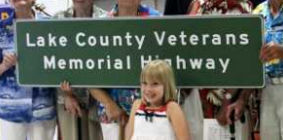
 Route 53 from its junction with Route 29 in Lower Lake to the
Junction of Route 20 in Clearlake Oaks is named the “Lake County
Veterans Memorial Highway”. This segment was named in honor of
the men and women who have served in the Armed Forces of the United States
of America to protect and defend our country and the freedom, rights, and
privileges enjoyed by all Americans. In particular, this naming honors
Lance Corporal Ivan Wilson, who was raised in the City of Clearlake in
Lake County. Lance Corporal Ivan Wilson joined the United States Marine
Corps in 2005. In 2007, he served in Iraq with the 2nd Battalion, 7th
Marine Regiment, 1st Marine Division, 1st Marine Expeditionary Force, and
he served in Afghanistan in 2008. On July 21, 2008, Lance Corporal Ivan
Wilson died while supporting combat operations in Afghanistan during
Operation Enduring Freedom. Lance Corporal Ivan Wilson was Lake County's
first military service member to die in the wars in Iraq and Afghanistan.
Named by Assembly Concurrant Resolution (ACR) 136, 6/2/2010, Resolution
Chapter 34.
(Image source: Lake County News)
 Business Routes
 Freeway
[SHC 253.1] Entire route. Added to the Freeway and Expressway system in 1959.
 Scenic Route
[SHC 263.1] Entire route.
 Interregional Route
[SHC 164.13] Entire route.
 Other WWW Links
 Statistics
Overall statistics for Route 53:
 Pre-1964 Legislative Route
The route that would become LRN 53 was first defined in the 1919 Third Bond Act as running from Rio Vista to Fairfield. In 1921, Chapter 831 extended the route by adding "The improved county road extending from the town of Rio Vista in the county of Solano to the city of Lodi in the county of San Joaquin, crossing the Sacramento River at Rio Vista, thence crossing Brannan, Andrus, and Tyler Islands to the San Joaquin Cty Line between Tyler and Staten Island to the mainland in San Joaquin County on to the improved county highway, thence through Thornton in an general easternly and southernly direction to Lodi." This was codified in 1935 into the state highway code as:
"Fairfield to [LRN 4] near Lodi via Rio Vista"
In 1951, Chapter 1562 changed "Fairfield" to "[LRN 7] near Fairfield". This route (LRN 7 near Fairfield to LRN 4 near Lodi via Rio Vista) was signed as Route 12.
© 1996-2020 Daniel P. Faigin.
Maintained by: Daniel P. Faigin
<webmaster@cahighways.org>.