
 California Highways:
Click here for a key to the symbols used. An explanation of acronyms may be found at the bottom of the page.
 Routing
 Post 1964 Signage History
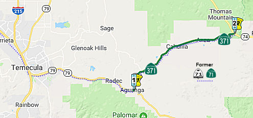
In 1974, Chapter 537 defined Route 371 via a transfer from Route 71: "Route 79 near Aguanga to Route 74 east of Anza." It runs along Cahuilla Road.
With respect to the transfer of Route 71 to Route 79 from County Sign Route R3 to
Temecula and the creation of Route 371, Scott Parker on AARoads noted: The
adoption of Route 79 along Winchester Road threw the area's highway
network into chaos -- and this was before I-15 (and I-215) were even on
the scene. The Division of Highways had recently brought the connector
from Route 79 near Aguanga northeast to Route 74 (i.e., originally part of
Route 71, now Route 371) into the state system as a "shortcut" from the
San Diego area to Coachella Valley cities. Without it, Route 71 would have
simply been truncated to end at Murietta, north of Temecula (at the site
of the present 15/215 split) -- but D8 chose to multiplex Route 71 and
Route 79 together for about 20 miles total to Aguanga, where Route 71
struck out over the new route NE to Route 74 (which was a bit awkward, as
Route 71 and Route 74 then intersected one another twice, at Elsinore and
near Anza). This arrangement lasted all of 8 years; after it was decided
to route I-15 down Route 71 from Corona south to Temecula. So, in 1974, D8
simply truncated Route 71 at the (then) US 395 junction in Murietta,
leaving Route 79 as the sole occupant of the Temecula-Aguanga route; the
Anza connector was redesignated as Route 371. This happened at the same
time as the commissioning of Route 330 due to the reroute of Route 30 away
from the San Bernardino mountains and over to Redlands -- so a 300-series
number wasn't an isolated case. Of course, when I-15 was completed south
of Corona, Route71 was cut back to its Corona-Pomona section, and US 395
was cut back to I-15 at Hesperia, with, first, I-15E and after 1982 I-215
taking over its routing. But today that relatively short (about 3 mile)
section of I-15 multiplexed with Route 79 in Temecula is one of the most
congested locations in the Inland Empire; and both adjacent sections of
Route 79 itself -- relinquished or not -- are the two most heavily
developed commercial "strips" in the area.
(Source: Scott Parker on AARoads, "Re: CA 79", 10/30/2019)
Route 371 forms the center segment of an east-west corridor formed by
parts of Route 79 and Route 74 between Temecula and the Palm
Springs-Coachella Valley area. This corridor serves as a bypass for
motorists traveling between San Diego County and Palm Springs-Coachella
Valley regions for the spectacular scenery and shorter distance (by 25
miles) versus the heavily congested freeway route via Route 60, I-10,
I-15, and I-215.
(Source: Noted by Peter Bryan, 2/3/2023)
 Pre 1964 Signage History
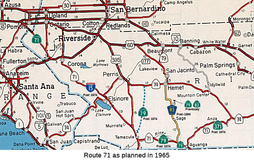 This was the eastern end of Route 71. It was LRN 277,
defined in 1959. Note that Route 371 starts at Post Mile RIV
R56.467, which is a vestige of its previous numbering as Route 71.
This was the eastern end of Route 71. It was LRN 277,
defined in 1959. Note that Route 371 starts at Post Mile RIV
R56.467, which is a vestige of its previous numbering as Route 71.
It appears that instead of building a new alignment for LRN 277 (as
planned in the 1960 state highway map), the Division of Highways opted to
assume maintenance of Cahuilla Road and Kenworthy-Bautista Road. LRN 277
can be seen aligned over Cahuilla Road and Kenworthy-Bautista Road on the
1962 Division of Highways State Map.
(Source: Gribblenation Blog "California State Route 371")
From the junction was LRN 78 (present-day Route 79), Route 71 continued to the W to Temecula, signed as Route 71. A short portion was cosigned as Route 71/Route 79 (the portion between the present-day Route 79/Route 371 junction and Riverside County Sign Route R3. Route 79 continued N along present-day Riverside County Sign Route R3, while Route 71 continued to the W. In 1966 (although historical information leads one to believe this happened in 1974), County Sign Route R3 was defined, and Route 79 continued cosigned with Route 71 all the way to US 395 (now I-15). In 1974, that segment was resigned as Route 79 only. Route 71 then turned N, continuing up what is now I-15 to Route 91. It was cosigned briefly with Route 91 to Corona, and then continued N to Pomona. This latter segment is all that remains of Route 71.
 Status
Note: Route 371 starts at Post Mile RIV R56.467, which is a vestige of its previous numbering as Route 71.
Left Turn Lane Project
The intersection of Route 371 and Route 79 (RIV R56.517) has demonstrated itself to be a high source of accidents, with four deaths occurring in the period from July 2001 to July 2002. As a result, the intersection is being redesigned. Two-lane Route 79 is the main link between Temecula and the Warner Springs and Santa Ysabel areas of San Diego County. Two-lane Route 371 is a well-traveled back road between Southwest County and Palm Springs. Currently, the two roads converge in Aguanga where an oddly configured intersection contributes greatly to the accident count. Westbound traffic on Route 79 must stop at the intersection, while eastbound traffic on Route 79 and traffic coming down a steep curvy grade from Anza on Route 371 proceed without stopping. Beginning in Summer 2003, work started to reconfigure the intersection to force drivers heading toward Temecula to stop and turn either left of right at a "T" intersection with Route 371. Turning left would take them quickly back to Route 79. Long-term improvements will include a merger lane from Route 371 to Route 79. As of April 2008, construction had been completed: It is now a standard T intersection with 3-way stop signs. Traffic leaving Route 371 is forced to turn, while travelers on Route 79 can proceed straight through. Most of Route 371 has been newly repaved as well. Most of the mile markers on Route 371 are very weathered (similar to the section of Route 74 between Route 371 and Route 111) but are marked with mileage between PM 57 (at the south end) and PM 78 (at the north end).
In July 2016, it was reported that Caltrans began
construction on a left turn lane project on a section of Route 371, in the
section of roadway along Route 371 two-tenths of one mile west of Bahrman
Road and just west of Bailiff Road in the unincorporated community of
Anza. The $520,000 project, which was awarded to All American Asphalt, is
expected to end by the beginning of September 2016. All American Asphalt
will begin clearing and grubbing on July 11, 2016 and is expected to
continue until July 15. During clearing and grubbing, Caltrans workers
focus on the preservation of public and private property and pay special
attention to environmentally sensitive areas. The project will be
constructing left turn lanes for both directions of travel on Route 371
and also be digging to allow access for underground utilities.
(Source: Anza Valley Outlook, 7/8/2016)
In October 2016, it was reported that Caltrans had
resumed work to complete the Route 371 Left Turn Lane Project at Bahram
Road that will include additional highway work requested by Anza residents
in an Anza Valley Municipal Advisory Council meeting in July. The project
scope had been altered to accommodate the extension of a two-way
continuous left turn lane from the center of Anza to the intersections at
Bahram rather than the originally planned left turn lanes at Bahram.
Requests from the Anza community at a recent Municipal Advisory Council
meeting led Caltrans to change the lane configuration based on the access
needs of community and local businesses. The changes being requested by
Anza residents required an additional $160,000 to be added to the original
$520,000 project. The planning change by Caltrans was the second in the
community with the first being a plan to cut some of the historic trees
along Route 371 in the main village area. Plans were changed on the
residents’ requests and updated engineering reports. The work was
scheduled for completion at the end of 2016.
(Source: Anza Valley Outlook, 10/9/2016)
Cahuilla Creek Upgrade (RIV 65.4)
In October 2018, it was reported that the CTC
authorized funding (as part of a larger package of bridge funding) to
upgrade Bridge 56-0490 (RIV 65.4, built in 1943, widened in 1977) at
Cahuilla Creek. This work is set to begin in January 2021
(Source: Press Enterprise, 10/25/2018)
In May 2020, the CTC approved for future consideration
of funding the Bridge Replacement and Bridge Rail Upgrade project
(08-Riv-74, PM 13.2, 33.9; 08-Riv-79, PM 9.3; 08-Riv-371, PM 65.4),
which will replace one bridge and make improvements to other bridges in
Riverside County. (PPNO 3002C). The project is located in the City of Lake
Elsinore on Route 74, among other locations, in Riverside County. The
Department plans to widen Leach Canyon Bridge on Route 74 to provide
standard shoulder width and upgrade the bridge rail, as well as make
improvements to other bridges. The purpose of the project is to improve
the safety of the traveling public by upgrading bridge rails to meet
current crash and safety standards. This project is fully funded and
currently programmed in the 2018 SHOPP for a total of $12,880,000 which
includes Construction (capital and support) and Right of Way (capital and
support). The total estimated project cost is $14 million. Construction is
estimated to begin fiscal year 2020-2021. The scope, as described for the
preferred alternative, is consistent with the project scope programmed by
the Commission in the 2018 SHOPP.
(Source: May 2020 CTC Agenda, Agenda Item 2.2c.(1))
In August 2020, the CTC approved the following
financial allocation for construction and construction support:
$9,969,000. 08-Riv-74 PM 13.2/34.0. Route 74 In and near the cities of
Lake Elsinore, Perris, Menifee and Hemet, at Leach Canyon Channel Bridge
No. 56-0750 and Blue Ridge Wash Bridge No. 56-0257; also on Route 79 and
Route 371, at Arroyo Seco Bridge No. 56-0189, and Cahuilla Bridge No.
56-0490. Outcome/Output: Upgrade bridge rail on three bridges, replace one
bridge, and extend one culvert. This project will upgrade bridges to meet
current crash and safety standards.
(Source: August 2020 CTC Agenda, Agenda Item
2.5b.(1) #39)
In March 2021, it was reported that construction was
beginning on the Leach Canyon Channel Bridge on Route 74 and Cahuilla
Creek Bridge on Route 371. The $13 million expansions, which are being
handled by Irvine-based Ortiz Enterprises Inc., are scheduled to start on
March 15, 2021. Traffic lights will be installed at the Leach Canyon
Bridge, on the north side of Lake Elsinore at Route 74 and Lincoln Street,
as part of the initial stage of the project. Additionally, traffic signals
are also due for installation in preparation for widening of the Cahuilla
Creek Bridge along Route 371, near Cahuilla Road, just north of the
Cahuilla Indian Reservation. Both expansion projects are slated for
completion in early 2024.
(Source: Lake Elsinore Patch, 3/5/2021)
Westbound Turn Lane near Homestead Road (08-Riv-371 67.1/67.4)
In January 2024, the CTC amended the following project
into the 2022 SHOPP: 08-Riv-371 67.1/67.4. PPNO 08-3021J; ProjID
0823000053; EA 1N530. Route 371 Near Temecula, from 0.1 mile west to 0.2
mile east of Homestead Road. Construct westbound left-turn lane and
retaining walls, and rehabilitate drainage system. Concurrent COS
allocation under Resolution FP-23-65; January 2024. Allocation ($
× $1000) PA&ED $1,599; PS&E $1,273; R/W Sup $226; Con Sup
$1,288 ; R/W Cap $94; Const Cap $2,164; TOTAL $6,644. FY25-26. BC:
7/2/2026.
(Source: January 2024 CTC Agenda, Agenda Item 2.1a #11)
In January 2024, the CTC approved the following
pre-construction-phase SHOPP allocation: $1,599,000. 08-Riv-371 67.1/67.4.
PPNO 08-3021J; ProjID 0823000053; EA 1N530. Route 371 Near Temecula, from
0.1 mile west to 0.2 mile east of Homestead Road. Construct
westbound left-turn lane and retaining walls, and rehabilitate drainage
system. Concurrent Amendment under SHOPP Amendment 22H-016; January 2024.
Programmed (Allocation, if different): PA&ED:
$1,599,000.
(Source: January 2024 CTC Agenda, Agenda Item 2.5b.(2a) #17)
Route 371 Safety Improvements
In January 2017, it was reported that Caltrans had
announced it will constructing rumble strips on the existing shoulder and
centerline of Route 371 in Anza from Wilson Valley Road to Cary Road (~
RIV R56.517 to RIV 67.845) and from Kirby Road to Route 371/Route 74 (~
RIV 72.813 to RIV 76.958) starting in 2018. Rumble strips on highways are
designed to let motorists know when they are drifting out or into the
opposing lane or into the shoulder. “Caltrans is currently in the
Preliminary Engineering phase, and we are developing the Environmental
Document and the Project Report,” said a news release sent by Elaheh
Hadipour, PE, Caltrans project manager. “The project is currently
programmed to start construction in late 2018.”
(Source: Anza Valley Outlook, 1/26/2017)
In April 2017, Caltrans issued a bulletin noting that,
starting May 14, 2018, they will be making safety improvements near
Cahuilla in two locations on Route 371 between Route 74 and Route 79 to
place centerline and shoulder rumble strips and install enhanced
visibility 6-inch striping. The first location is from Wilson Valley Road
to Cary Road (post mile 60.2 to post mile 67.7) and the second area is
from Kirby Road to Route 74 (post mile 72.8 to 77.1.) The estimated $756
thousand project, awarded to Jabre Contracting Inc., is anticipated to
last less than thirty working days.
(Source: Caltrans Commuter Alert 4/23/2018)
 Naming
"Cahuilla" Road
 The portion of Route 371 from Tribal Road to Howard Road (~ RIV 67.12 to RIV 68.717)near
the community of Anza in Riverside County is officially named the "Special
Deputy Frank Hamilton Memorial Highway". It was named in memory of
Frank Hamilton, a Native American and a Cahuilla tribal member from the
Anza area, who in 1895 was working as a Riverside County special deputy
sheriff. Hamilton acted as a law enforcement officer for the Riverside
County Sheriff’s Office in the areas surrounding the Cahuilla and
Ramona Reservations (Anza) area, including the area surrounding the town
of San Jacinto. Hamilton had family ties to both reservations. Hamilton,
who was 34 years of age and unmarried, was the son of a prominent rancher,
James Hamilton, namesake of the Hamilton School in the community of Anza.
He resided at the family ranch, which was first in Cahuilla, now present
day Anza. The ranch then moved to Kenworthy, presently known as Garner
Valley. In the early years of Riverside County, special deputies were used
throughout the county to support the operation of the Riverside County
Sheriff’s Office. In the first few years of its existence, the
Riverside County Sheriff’s Office consisted of one sheriff and two
deputy sheriffs. Riverside County was incorporated on May 9, 1893. Special
Deputy Frank Hamilton was the first deputy sheriff in Riverside County to
be murdered in the line of duty and his killing was the subject of the
first murder trial held in Riverside County’s history. On the
evening of April 8, 1895, Special Deputy Frank Hamilton was in the town of
San Jacinto tending to his duties as a special deputy sheriff. He was in
the town saloon when a disagreement erupted between him and Charles
Marshall, who had greeted Special Deputy Frank Hamilton with a racial
epithet. Marshall became enraged over the disagreement and left. Special
Deputy Frank Hamilton had told Marshall to go away and that he did not
want any trouble with him, but Marshall retrieved a revolver and went in
search of Special Deputy Frank Hamilton. Marshall located Special Deputy
Frank Hamilton in an alleyway adjacent to the town saloon, and, without
warning, began firing, hitting Special Deputy Frank Hamilton twice as he
returned fire and managed to wound Marshall. Special Deputy Frank Hamilton
succumbed to his gunshot wounds the following day, April 9, 1895. Named by
Senate Concurrent Resolution 51, Resolution Chapter 2, on February 1,
2016.
The portion of Route 371 from Tribal Road to Howard Road (~ RIV 67.12 to RIV 68.717)near
the community of Anza in Riverside County is officially named the "Special
Deputy Frank Hamilton Memorial Highway". It was named in memory of
Frank Hamilton, a Native American and a Cahuilla tribal member from the
Anza area, who in 1895 was working as a Riverside County special deputy
sheriff. Hamilton acted as a law enforcement officer for the Riverside
County Sheriff’s Office in the areas surrounding the Cahuilla and
Ramona Reservations (Anza) area, including the area surrounding the town
of San Jacinto. Hamilton had family ties to both reservations. Hamilton,
who was 34 years of age and unmarried, was the son of a prominent rancher,
James Hamilton, namesake of the Hamilton School in the community of Anza.
He resided at the family ranch, which was first in Cahuilla, now present
day Anza. The ranch then moved to Kenworthy, presently known as Garner
Valley. In the early years of Riverside County, special deputies were used
throughout the county to support the operation of the Riverside County
Sheriff’s Office. In the first few years of its existence, the
Riverside County Sheriff’s Office consisted of one sheriff and two
deputy sheriffs. Riverside County was incorporated on May 9, 1893. Special
Deputy Frank Hamilton was the first deputy sheriff in Riverside County to
be murdered in the line of duty and his killing was the subject of the
first murder trial held in Riverside County’s history. On the
evening of April 8, 1895, Special Deputy Frank Hamilton was in the town of
San Jacinto tending to his duties as a special deputy sheriff. He was in
the town saloon when a disagreement erupted between him and Charles
Marshall, who had greeted Special Deputy Frank Hamilton with a racial
epithet. Marshall became enraged over the disagreement and left. Special
Deputy Frank Hamilton had told Marshall to go away and that he did not
want any trouble with him, but Marshall retrieved a revolver and went in
search of Special Deputy Frank Hamilton. Marshall located Special Deputy
Frank Hamilton in an alleyway adjacent to the town saloon, and, without
warning, began firing, hitting Special Deputy Frank Hamilton twice as he
returned fire and managed to wound Marshall. Special Deputy Frank Hamilton
succumbed to his gunshot wounds the following day, April 9, 1895. Named by
Senate Concurrent Resolution 51, Resolution Chapter 2, on February 1,
2016.
(Image source: Ramona Band of Cahuilla)
 Freeway
[SHC 253.1] Entire route. Added to the Freeway and Expressway system in 1959.
 Other WWW Links
 National Trails
 This route is part of the De Anza National Historic Trail.
 Statistics
Overall statistics for Route 371:
© 1996-2020 Daniel P. Faigin.
Maintained by: Daniel P. Faigin
<webmaster@cahighways.org>.
 From Route
  Route 330
 Route 380