
 California Highways:
Click here for a key to the symbols used. An explanation of acronyms may be found at the bottom of the page.
 Routing
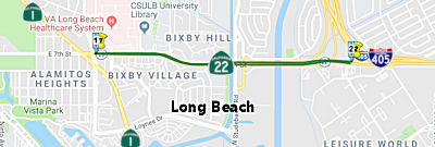 From Route 1 near Long Beach to
Route 405.
From Route 1 near Long Beach to
Route 405.
 Post 1964 Signage History
 This segment is unchanged from
its 1963 definition. Note that there were originally plans for a Route 1
freeway through Long Beach that connected with the Route 22 freeway on 7th
(hence, the reference to Route 1 in the definition).
This segment is unchanged from
its 1963 definition. Note that there were originally plans for a Route 1
freeway through Long Beach that connected with the Route 22 freeway on 7th
(hence, the reference to Route 1 in the definition).
With respect to the Long Beach portion of Route 22: Conversion of
existing Route 22 west of Los Cerritos Channel as freeway to Route 1/Pacific Highway was originally planned to begin after 1970. The
October/November 1965 California Highways & Public Works announced the
California Highway Commission officially adopted a new segment of the
Route 22/Garden Grove Freeway from Los Cerritos Channel west to Route 1 in
Long Beach. 1972 Legislative Chapter 150 deleted the Garden Grove Freeway
extension west to Route 1 in Long Beach. This measure ensured Route 22
remained on 7th Street where it still meets Route 1/Pacific Coast Highway
at its western terminus.
(Source: Gribblenation Blog (Tom Fearer), "California State Route 22 the Orange Crush of the Garden Grove Freeway", 2/22/2022)
 Pre 1964 Signage History
In 1933, the state was permitted to take over maintenance of highways within cities. This led to LRN 179 being added to the State Highway System with the definition: "LRN 60 near Long Beach to Santa Ana"
In 1934, Route 22 was signed from Jct. Route 3 (LRN 60, US 101A, later Route 1) N of Seal Beach to Jct. US 101, via Ocean Ave. Before 1964, this routing ran from US101A (LRN 60) at Bellflower Blvd. to the approximate junction with the future I-405 (LRN 158; near Los Alimitos Blvd, Route 35). It was part of LRN 179, defined in 1933.
As of 1938, Route 22 followed LRN 179 largely on Ocean Avenue (now mostly
Garden Grove Boulevard) from US 101A/LRN 60 in Long Beach to US 101/LRN 2
at Main Street in Santa Ana.
(Source: Gribblenation Blog (Tom Fearer), "California State Route 22 the Orange Crush of the Garden Grove Freeway", 2/22/2022)
 Status
This segment runs along 7th Street in Long Beach.
Studebaker Road Ramps (07-LA-22 PM 1.3)
") The 2020 SHOPP, approved in May 2020, included the following New Mobility item of
interest: 07-LA-22 PM 1.3 PPNO 5613 Proj ID 0719000264 EA 35980. Route 22
in Long Beach, at Studebaker Road. Financial Contribution Only (FCO) to
city of Long Beach to realign entrance and exit ramps at a new
intersection at Studebaker Road and relinquish right-of-way (R/W) along
the original alignment of the ramps to Long Beach. Programmed in FY22-23,
with construction scheduled to start at the end of March 2023. Total
construction contribution is $1,900K.
The 2020 SHOPP, approved in May 2020, included the following New Mobility item of
interest: 07-LA-22 PM 1.3 PPNO 5613 Proj ID 0719000264 EA 35980. Route 22
in Long Beach, at Studebaker Road. Financial Contribution Only (FCO) to
city of Long Beach to realign entrance and exit ramps at a new
intersection at Studebaker Road and relinquish right-of-way (R/W) along
the original alignment of the ramps to Long Beach. Programmed in FY22-23,
with construction scheduled to start at the end of March 2023. Total
construction contribution is $1,900K.
(Source: 2020 Approved SHOPP a/o May 2020)
In January 2023, the Transportation Conformity Working
Group (TCWG) was provided information on this project: The proposed
project would realign the Route 22 westbound entrance and exit ramps at
Studebaker Road and construct a new signalized intersection at the ramp
termini with Studebaker Road. The proposed project also includes the
construction of curb ramps, new sidewalk, and a separated bikeway along
Studebaker Road. The proposed project would eliminate the existing Route 22 westbound on-/off-ramps at College Park Drive and construct a new
on/off-ramp at Studebaker Road. The intersection of Studebaker Road and
College Park Drive would also be relocated approximately 300 feet north to
increase the distance between the intersections of Studebaker Road at
College Park Drive and the new on-/off-ramps at Studebaker Road.
Additionally, the proposed project includes the restriping of Studebaker
Road to provide a Class IV Separated Bikeway on the west side of the
roadway to accommodate both directions of bicycle travel. This would
require the reallocation of travel lanes in the northbound direction
including the reduction from two through lanes to one through lane
northbound along Studebaker Road at the Route 22 overcrossing.
Specifically, the lane reduction would begin north of the Route 22 east
on-/off-ramp and Studebaker Road intersection and along Studebaker Road
northbound on the Route 22 overcrossing. Studebaker Road northbound would
widen back to two through travel lanes just north of the Route 22
overcrossing such that two northbound through lanes would be provided at
the Route 22 westbound on-/off-ramp and Studebaker Road signalized
intersection. Additionally, the westbound right turn movement from the
Route 22 eastbound off-ramp would be converted from a channelized yield
right turn to a signalized movement to avoid potential conflicts between
merging through traffic along Studebaker Road and right-turning off-ramp
traffic just north of the Route 22 eastbound ramp intersection. Two travel
lanes would be maintained along Studebaker Road southbound. The proposed
project does not propose new access or restrict existing access. Instead,
the proposed project focuses on a reconfiguration of the existing
intersection alignment to provide a more-direct connection between Route 22 westbound and Studebaker Road and the inclusion of the Studebaker Road
bikeway. A single lane loop on-ramp with a bike lane, but without ramp
metering is proposed from Studebaker Road to Route 22 westbound. A
Studebaker Road crossing would be provided on the south intersection leg
to connect the separated bikeway on the west side of Studebaker Road to
the bike lane on the loop on-ramp.
(Source: TCWG January 24, 2023 Attachment 4.2-1 TCWG Review of Project's Regional Significance)
In June 2023, the CTC approved the following amendment
to a project already in the 2022 SHOPP: 07-LA-22 1.3. PPNO 07-5613;
ProjID 0719000264; EA 35980. Route 22 In Long Beach, at
Studebaker Road. Financial Contribution Only (FCO) to city of Long Beach
to realign entrance and exit ramps at a new intersection at Studebaker
Road and relinquish right-of-way (R/W) along the original alignment of
the ramps to Long Beach. Note: Delete project. The city of Long
Beach is unable to secure their portion of the funding at this time.
Allocation Changes ($ × 1,000): Const Cap $1,900; TOTAL $1,900.
(Source: June 2023 CTC Agenda, Agenda Item 2.1a.(2d) #19)
According to the Long Beach Press-Telegram in January 2010, there are plans for a yearlong reconstruction project on the Seventh Street bridge in East Long Beach (~ LA 1.42, likely Bridges 53-0302L and -0302R, dating to 1959 and 1941, respectively). This was originally on track for 2010, but could be delayed until 2011 due to state budget problems. The Orange County Transportation Authority, which is overseeing the project, said state funding needed for the project may not be available in time for the planned June 2010 construction launch. The project involves widening and reconfiguring the Seventh Street connector bridge to I-405 and I-605. The route handles some 90,000 vehicles each day, and diverting that traffic during construction has become a major concern for residents in and around adjacent neighborhoods. OCTA has proposed re-routing motorists north on Studebaker Road for connections to the I-405 and I-605.
 Freeway
[SHC 253.3] From Studebaker Road in Long Beach to Route 405.
In 1959, this entire segment was part of the Freeway and Expressway system. In 1972, Chapter 150 deleted the portion to the W of Studebaker Road.
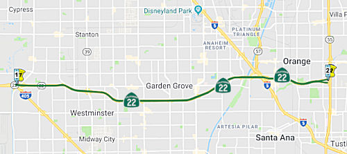 From Route 405 to Route 55 near Orange.
Post 1964 Signage HistoryThis segment is unchanged from its 1963 definition. Note that there was originally a segment (c) as well; this was later removed (see below).
At one time, there were rumored plans to build an expressway along the old Pacific Electric rail corridor that roughly parallels the current Route 22; this plan has been scrapped. Under this plan, there would have been a four-lane road extending south from the Route 22 Freeway and connecting with Santa Ana Boulevard. This would have involved raising the cross streets of Harbor and Westminster Blvds so motorists wouldn't have to stop at traffic signals, and adding HOV lanes and auxiliary lanes from Harbor Boulevard to the Santa Ana (I-5) Freeway interchange and from Tustin Avenue to Glassell Avenue. The project would also have involved reconstructing The City Drive off-ramp in Orange to eliminate traffic-clogging weaves. These plans were dreamed up in 2000-2001; scrapped in 2002.
Pre 1964 Signage HistoryIn 1934, Route 22 was signed from Jct. Route 3 (US 101A, later Route 1) N of Seal Beach to Jct. US 101, via Ocean Ave. Prior to the construction of the freeway, this segment ran along Garden Grove Blvd (in 1935, Ocean Avenue) from Los Alimitos Blvd, Route 35, LRN 170) to US 101 (now I-5). It was part of LRN 179. Portions of Garden Grove Blvd are still maintained by the state. For example, the portion between Beach Blvd and Fern Street was approved for rehabilitation and relinquishment to the state as late as November 2000.
As of 1938, Route 22 followed LRN 179 largely on Ocean Avenue (now mostly
Garden Grove Boulevard) from US 101A/LRN 60 in Long Beach to US 101/LRN 2
at Main Street in Santa Ana. In Santa Ana, the route was from Ocean Avenue
Main Street in Santa Ana via Memory Lane, Flower Avenue and 17th Street.
The freeway routing was defined by early 1954. At that time, the eastern
terminus of Route 22/LRN 179 was moved north on Main Street in Santa Ana
to meet US 101/LRN 2 at the Santa Ana Freeway. The transition to Main
Street was similar; as of 1957, it was Garden Grove Boulevard to Main
Street via Memory Lane, Flower Street, Park Lane (then Boulevard) and
Santa Clara Avenue. 1957 Legislative Chapter 36 extended LRN 179 to Route 55/LRN 43 in Orange. This extension of LRN 179 consumed part of what had
been LRN 182 between Main Street and Route 55/LRN 43. This extension was
via Main Street and Chapman Avenue in Orange. The freeway conversion was
eventually completed by 1966 (this was important, as the southern segment
of I-405 took longer to complete, and the routing of Route 22 to I-5 was
the bypass until it was completed). Route 22 was completed to Route 55
during 1967.
(Source: Gribblenation Blog (Tom Fearer), "California State Route 22 the Orange Crush of the Garden Grove Freeway", 2/22/2022)
By 1961, Route 22 took a little jaunt to connect between I-5/US 101 and Garden Grove Boulevard: from I-5/US 101, westbound Route 22 followed Santa Clara Avenue west, Bristol Street north, and West Memory Lane west into Garden Grove Boulevard.
The portion of this segment between US 101 and Route 55 was later signed as Route 22, and was also part of LRN 179.
StatusRoute 22/I-405 HOV Connectors (~ ORA R0.746)
![[TCRP 70]](maps/022-tcrp-70.jpg) In December 2005, utilizing Measure M money, the OCTA authorized construction of HOV
connector ramps between I-405 and Route 22. These were also submitted for
funding from the 2007 Corridor Mobility Improvement Account, which was
approved for $200 million. In August 2007, the CTC approved transferring
$1,074,000 in TCRP funding from TCRP Project #70.1 (Soundwalls) to TCRP
Project #70.2 (Construction of the HOV widening and auxiliary lanes
including replacement planting). They also redistributed $31,000 in TCRP
funds from Project Approval and Environmental Document (PA&ED) to
Construction. Completion of this is scheduled for FY 10/11.
In December 2005, utilizing Measure M money, the OCTA authorized construction of HOV
connector ramps between I-405 and Route 22. These were also submitted for
funding from the 2007 Corridor Mobility Improvement Account, which was
approved for $200 million. In August 2007, the CTC approved transferring
$1,074,000 in TCRP funding from TCRP Project #70.1 (Soundwalls) to TCRP
Project #70.2 (Construction of the HOV widening and auxiliary lanes
including replacement planting). They also redistributed $31,000 in TCRP
funds from Project Approval and Environmental Document (PA&ED) to
Construction. Completion of this is scheduled for FY 10/11.
However, the project was speeded up through regional stimulus (ARRA) funds. In early May 2009, the OCTA voted unanimously to spend $4.2 million to purchase six sections of land owned by the U.S. Navy, the Orange County Flood Control District and Bixbybit-Bixby offices. The OCTA intends to extend car-pool lanes so that commuters can switch freeways without leaving the special lanes at the I-405/I-605/22 junction in far-west Orange County. Among the properties the OCTA intends to purchase is a 20-foot-wide strip of land on Navy property on the south side of the 405. Also, a tiny section of parking lot owned by Bixbybit-Bixby is planned for acquisition. Freeway lanes will creep closer to some businesses and homes in the four-mile project area, from Valley View Street in Garden Grove to the I-405/I-605 connector in Los Alamitos. As part of this project, some lanes on the Seal Beach Boulevard bridge in Seal Beach will be closed, and the 7th Street bridge in Long Beach will close for a year. Construction for the project is expected to begin in early 2010 and will be completed by 2013.
In July 2009, the CTC approved transfer of CMIA funds from a Route 91 project switched to ARRA funding. This transfer added $2,286,000 CMIA to the Route 22/I-405/I-605 HOV Connector with ITS Elements project (PPNO 2868C), resulting in a total of $202,286,000 CMIA programmed on this project. The additional funds from CMIA will replace $2,286,000 in Congestion Mitigation and Air Quality (CMAQ) funds. This project also has an estimated construction capital cost increase of $8,200,000 that will be funded by transferring CMAQ funds from right of way. The cost increase is the result of moving planned utility relocation work from the right of way phase to the construction phase of the project. The overall budget for the project does not change.
In May 2010, it was reported that Caltrans is preparing to issue contracts for the project, which has been named the “West County Connector Project”. The project will connect and enlarge the carpool lanes from I-405, I-605, and Route 22. There are two phases: an East phase from Valley View Street to just east of Seal Beach Boulevard, and a West phase from Seal Beach Boulevard through I-605. The East Phase contract should be awarded in May 2010, with construction starting in June. The contract for the West Phase should be awarded in August 2010, with construction starting in Fall 2010. Construction is expected to complete in 2014. Information on the project may be found at http://www.octa.net/westcounty.aspx.
Route 22 HOV Improvements (~ ORA R0.746 to R13.046)
![[New 22]](images/sr22.jpg) In Summer 2004, the OCTA
selected a contractor to make improvements to the freeway section of Route 22; specifically, OCTA chose the construction team of Granite Meyers-Rados
for a $390-million contract to design and build the improvements. All the
companies in the joint venture — C.C. Meyers and Rados — are
local construction firms. The project, which has a total cost of $490
million, includes buying two homes and portions of several businesses
along the route. It is expected to be completed by the end of 2006. It
will widen the freeway along 12 miles, fromValley View Street near the San
Diego Freeway to its eastern connection at the Costa Mesa Freeway.
Improvements include building two carpool lanes, adding two auxiliary
lanes between the Santa Ana Freeway and Beach Boulevard, elevating the
freeway connector with the Orange Freeway at The City Drive to eliminate
chronic traffic weaving, and building new on-and-off ramp lanes and
additional sound walls State transportation officials originally planned
to oversee the project and finish it in 2011, but funding dried up and
OCTA wanted a quicker schedule. Construction had started by December 2004.
It was originally scheduled for completion at the end of November 2006. To
do this, OCTA intended to spend an extra $32 million to ensure that 28
freeway bridges are sufficiently strengthened to meet earthquake
standards, as well as providing rubberized asphalt and improved signs.
In Summer 2004, the OCTA
selected a contractor to make improvements to the freeway section of Route 22; specifically, OCTA chose the construction team of Granite Meyers-Rados
for a $390-million contract to design and build the improvements. All the
companies in the joint venture — C.C. Meyers and Rados — are
local construction firms. The project, which has a total cost of $490
million, includes buying two homes and portions of several businesses
along the route. It is expected to be completed by the end of 2006. It
will widen the freeway along 12 miles, fromValley View Street near the San
Diego Freeway to its eastern connection at the Costa Mesa Freeway.
Improvements include building two carpool lanes, adding two auxiliary
lanes between the Santa Ana Freeway and Beach Boulevard, elevating the
freeway connector with the Orange Freeway at The City Drive to eliminate
chronic traffic weaving, and building new on-and-off ramp lanes and
additional sound walls State transportation officials originally planned
to oversee the project and finish it in 2011, but funding dried up and
OCTA wanted a quicker schedule. Construction had started by December 2004.
It was originally scheduled for completion at the end of November 2006. To
do this, OCTA intended to spend an extra $32 million to ensure that 28
freeway bridges are sufficiently strengthened to meet earthquake
standards, as well as providing rubberized asphalt and improved signs.
The overall project consists of adding HOV lanes in each direction of Route 22, from I-405 to Route 55, adding auxiliary lanes where needed, related structural and soundwall construction and improvements, and replacement planting. The overall project has been divided into two subprojects: #70.1 – Construction of soundwalls at various locations along the corridor, and #70.2 – Construction of the HOV widening and auxiliary lanes including replacement planting. Completion is currently scheduled for November 2006. Alas, there were some delays in the project, but the bulk of the project was completed in early 2007. This project included two continuous access carpool lanes (one in each direction) from Tustin Avenue to Magnolia Street, general purpose and auxiliary lanes (the far outside right lanes when merging onto the freeway) between Magnolia Street and Tustin Avenue, newly realigned eastbound Route 22 to northbound I-5/ Route 57 “horseshoe” connector, a realigned eastbound Route 22 to southbound I-5 connector, a new southbound I-5/Route 57 flyover connector to the westbound Route 22, a new interachange at The City Drive, a "collector-distributor" road (barrier separated lanes designed to facilitate ramp movements at The City Drive, Bristol Street, southbound I-5 and northbound I-5/Route 57 connectors) on the eastbound Route 22 between The City Drive and I-5. Further improvements are planned, such as the Magnolia Street bridge and all carpool and auxiliary lanes west of Magnolia Street to Valley View Street, the Beach Boulevard interchange, the Valley View Street on- and off-ramps, the Magnolia Street westbound on-ramp and eastbound off-ramp , new lanes on The City Drive, Garden Grove Boulevard/Fairview and Magnolia Street, soundwalls and medians, and a Rubberized Asphalt overlay between Euclid Street and Magnolia Street.
The Route 22 improvements were completed in May 2007.
Valley View to Springdale Aux Lane (12-Ora-22 R0.9/R1.9)
In August 2023, the CTC amended the 2022 SHOPP to add
the following project: 12-Ora-22 R0.9/R1.9. PPNO 12-2870A; ProjID
1221000088; EA 0T020. Route 22 In Garden Grove, from Valley View Street to
Springdale Street. Construct auxiliary lane and modify exit ramp.
Concurrent COS allocation under Resolution FP-23-16; August 2023.
Allocation ($ × 1,000): PA&ED $1,136; PS&E $1,384; R/W Sup
$298; Con Sup $1,978; R/W Cap $10; Const Cap $7,118; TOTAL $11,924.
FY23-24 through FY25-26. Begin Const: 2/1/2027.
(Source: August 2023 CTC Agenda, Agenda Item 2.2a.(1a) #49)
In August 2023, the CTC approved the following SHOPP
Pre-Construction Phase (environmental support, design, and R/W support)
allocation: $1,136,000. 12-Ora-22 R0.9/R1.9. PPNO 12-2870A; ProjID
1221000088; EA 0T020. Route 22 In Garden Grove, from Valley View Street to
Springdale Street. Construct auxiliary lane and modify exit ramp.
Concurrent Amendment under SHOPP Amendment 22H-011; August 2023.
Allocation: PA&ED $1,136,000.
(Source: August 2023 CTC Agenda, Agenda Item 2.5b.(2a) #22)
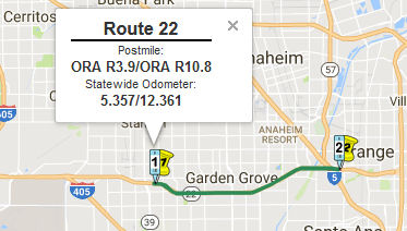
Garden Grove Improvements (12-Ora-22 R3.9/R10.8)
The SAFETEA-LU act, enacted in August 2005 as the reauthorization of TEA-21, provided the following expenditures on or near this route:
In October 2015, the CTC approved the following SHOPP funding: 12-Ora-22 R3.9/R10.8 Route 22 In the cities of Garden Grove, Orange and Santa Ana, from Route 39 (Beach Boulevard) to Route 5. Modify ramps and add auxiliary lane. PAED: 03/15/17 R/W: 05/15/18 RTL: 06/15/18 CCA: 10/15/20 Costs: $20K (R/W); $10,522K (C). Completion FY17/18. Support costs: PA & ED $950K; PS & E $2,000K; RW Sup $200K; Con Sup $2,100K; Total $5,250K.
 In June 2017, the CTC approved for future consideration of funding a project on Route 22
(12-Ora-22, PM R3.9/R10.8) in Orange County that proposes safety
improvements on eastbound Route 22 (Garden Grove Freeway) in the cities of
Garden Grove, Orange and Santa Ana in Orange County. The project proposes
to convert the existing collector distributor road to a freeway direct
connector servicing I-5 southbound. The project also includes new and
upgrading of traffic control devices as well as a new Changeable Message
Sign. The project will be funded from State Highway Operation and
rotection Program (SHOPP) funds and is programmed in the 2016 SHOPP for an
estimated $17.5 million construction (capital and support) and Right of
Way (capital and support). Construction is tentatively scheduled to begin
in Fiscal Year 2018-19. The scope, as described for the preferred
alternative, is consistent with the project scope programmed by the
Commission in the 2016 SHOPP. A copy of the MND has been provided to
Commission staff. The project will result in less than significant impacts
to the environment after mitigation. The following resource area may be
impacted by the project: cultural resources. Avoidance and minimization
measures will reduce any potential effects on the environment. These
measures include, but are not limited to, if cultural materials are
discovered during construction, all earthmoving activities adjacent to the
discovery site will be diverted until a qualified archeologist can
evaluate the find, a Paleontology Mitigation Plan shall be prepared for
the project, and paleontological monitoring will be performed on-site
during construction. As a result, an MND was completed for this project.
In June 2017, the CTC approved for future consideration of funding a project on Route 22
(12-Ora-22, PM R3.9/R10.8) in Orange County that proposes safety
improvements on eastbound Route 22 (Garden Grove Freeway) in the cities of
Garden Grove, Orange and Santa Ana in Orange County. The project proposes
to convert the existing collector distributor road to a freeway direct
connector servicing I-5 southbound. The project also includes new and
upgrading of traffic control devices as well as a new Changeable Message
Sign. The project will be funded from State Highway Operation and
rotection Program (SHOPP) funds and is programmed in the 2016 SHOPP for an
estimated $17.5 million construction (capital and support) and Right of
Way (capital and support). Construction is tentatively scheduled to begin
in Fiscal Year 2018-19. The scope, as described for the preferred
alternative, is consistent with the project scope programmed by the
Commission in the 2016 SHOPP. A copy of the MND has been provided to
Commission staff. The project will result in less than significant impacts
to the environment after mitigation. The following resource area may be
impacted by the project: cultural resources. Avoidance and minimization
measures will reduce any potential effects on the environment. These
measures include, but are not limited to, if cultural materials are
discovered during construction, all earthmoving activities adjacent to the
discovery site will be diverted until a qualified archeologist can
evaluate the find, a Paleontology Mitigation Plan shall be prepared for
the project, and paleontological monitoring will be performed on-site
during construction. As a result, an MND was completed for this project.
Route 22 / I-5 / Route 57 Interchange Improvements (12-Ora-22 R5.6/R10.9)
 In August 2018, the CTC approved $14,800,000 in SHOPP funding for Orange
12-Ora-22 R5.6/R10.9 Route 22 In the cities of Garden Grove, Orange and
Santa Ana, from 0.1 mile west of Brookhurst Street to Bedford Road.
Outcome/Output: Improve safety and enhance traffic flow by reconfiguring
collector-distributor roadway channelization and connector ramps to Route 5 and Route 57, and adding auxiliary lane. This project will reduce the
number and severity of collisions.
In August 2018, the CTC approved $14,800,000 in SHOPP funding for Orange
12-Ora-22 R5.6/R10.9 Route 22 In the cities of Garden Grove, Orange and
Santa Ana, from 0.1 mile west of Brookhurst Street to Bedford Road.
Outcome/Output: Improve safety and enhance traffic flow by reconfiguring
collector-distributor roadway channelization and connector ramps to Route 5 and Route 57, and adding auxiliary lane. This project will reduce the
number and severity of collisions.
(Source: August 2018 CTC Agenda Item 2.5f.(3) Item
19)
At the end of December 2018, it was reported that one
of the projects planning in Orange County in 2019 is on eastbound Route 22
in Orange and Santa Ana, where the so-called horseshoe connector between
Route 22, I-5 and Route 57 will be widened by a lane. Much of the concrete
barriers will be removed. Period: Mid-2019 to mid-2021. Cost: $20 million.
(Source: OC Register, 12/31/2018)
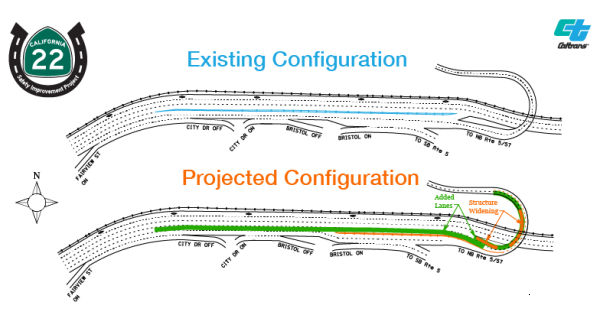
The project page provides additional information on the
horseshoe reconfiguration. The Route 22 Saftety Improvement project
proposes to shorten the length of the collector-sistributor road and
reconfigure Eastbound Route 22 at the Horseshoe connector. This work is
the most recent in Caltrans’ efforts to improve the conditions on
Route 22. In 2007, Caltrans and OCTA finished an improvement project on
the Garden Grove Freeway that widened the freeway (adding HOV, general
purpose, and auxiliary lanes) massively improving traffic flow and safety.
They also added the collector-distributor road between The City Drive in
Orange and I-5 and Route 57. Through this new safety project, Caltrans
will further optimize that collector-distributor road in specific and
Route 22 in general. Specifically, over $20 million in improvements will
be made to the Eastbound segment of the Route 22, widening the inside of
the horseshoe connector to three lanes that service Northbound I-5 and
Northbound Route 57, removing a half a mile of the collector-distributor
road concrete barrier, and extending the concrete barrier to provide
access to the horseshoe connector.
(Source: District 12 "SR-22 Safety Improvement Project" Project Page)
In December 2008, the CTC reviewed the Final Environmental Impact Report (FEIR) for the Block at Orange Expansion Project (Expansion Project) (ORA L9.7) located in the central portion of Orange County in the City of Orange. The Expansion Project is proposed to expand the Block at Orange located at 20 City Boulevard West in the City of Orange. The 85.67 acre site is currently developed with a variety of retail shops and restaurants, and a 30-screen movie theater. The Expansion Project includes 11,000 square meters gross building area of retail space, an apartment complex that includes 500 units, two hotels (300 units), parking improvements, and circulation improvements including a new City street (referred to as the "The Block Drive" or the "Fourth Leg") located at Metropolitan Drive opposite the westbound Route 22 on/off ramps. The CTC approved consideration of a new public road connection directly opposite the Route 22 westbound The City Drive on/off ramps at Metropolitan Drive (ORA L9.7). The proposed project is to be funded entirely by the City of Orange without the use of State or Federal funds. Construction is expected to begin January 2009.
Parker St to Cambridge St Safety Improvements (12-Ora-22 PM R11.6/R12.5)
In October 2020, the CTC amended the following project
into the 2020 SHOPP: 12-Ora-22 PM R11.6/R12.5. PPNO 2977 ProjID
1219000104. EA 0S190. Route 22 in the cities of Orange and Santa Ana, from
east of Parker Street to east of Cambridge Street. Restripe lanes to
provide for safer merging, widen to extend auxiliary lane, add and upgrade
signs, and add safety lighting. PA&ED: $1,417K; PS&E: $1,814K; R/W
Sup: $0K; Con Sup: $1,933K; R/W Cap: $0; Const Cap: $7,205; Total:
$12,369K. Begin Const: 10/7/2024.
(Source: October 2020 CTC Agenda, Agenda Item
2.1a.(1a) #25)
In October 2020, the CTC approved the following SHOPP
Support Phase allocation: $1,417,000 for PA&ED for 12-Ora-22 PM
R11.6/R12.5. PPNO 12-2977 ProjID 1219000104 EA 0S190. Route 22 In the
cities of Orange and Santa Ana, from east of Parker Street to east of
Cambridge Street. Restripe lanes to provide for safer merging, widen to
extend auxiliary lane, add and upgrade signs, and add safety lighting.
(Concurrent Amendment under SHOPP Amendment 20H-003; October 2020.)
(Source: October 2020 CTC Agenda, Agenda Item
2.5b.(2a) #40)
 Naming
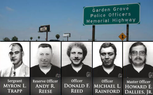 The 8-mile portion of Route 22 in the City of Garden Grove (~
ORA R0.746 to ORA R9.385) is named the "Garden Grove Police Officers
Memorial Highway, honoring Myron L. Trapp, Andy R. Reese, Donald R.
Reed, Michael L. Rainford, and Howard E. Dallies, Jr.. It was named
in honor of five Garden Grove municipal police officers killed in the line
of duty, as the City of Garden Grove has had more police officers killed
in the line of duty than any other municipal police agency in Orange
County. It was named by Assembly Concurrent Resolution (ACR) 127,
Resolution Chapter 95, on 7/23/2008. The sign was dedicated on May 14,
2009. The five officers were:
The 8-mile portion of Route 22 in the City of Garden Grove (~
ORA R0.746 to ORA R9.385) is named the "Garden Grove Police Officers
Memorial Highway, honoring Myron L. Trapp, Andy R. Reese, Donald R.
Reed, Michael L. Rainford, and Howard E. Dallies, Jr.. It was named
in honor of five Garden Grove municipal police officers killed in the line
of duty, as the City of Garden Grove has had more police officers killed
in the line of duty than any other municipal police agency in Orange
County. It was named by Assembly Concurrent Resolution (ACR) 127,
Resolution Chapter 95, on 7/23/2008. The sign was dedicated on May 14,
2009. The five officers were:
(Image source: City of Garden Grove; City of Garden Grove)
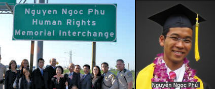 The Beach Boulevard interchange on Route 22 in the County of
Orange (~ ORA R3.583) is named the "Nguyễn Ngọc Phú
Human Rights Memorial Interchange". This segment was named in memory
of Nguyễn Ngọc Phú, a young student, a community leader,
and an ardent voice for freedom, human rights, and democracy, particularly
in Vietnam. Nguyễn was born in Vietnam on November 27, 1983, and
immediately faced challenging conditions. His father served honorably as a
South Vietnamese military police officer and suffered at the hands of a
communist government as a prisoner in a concentration camp for seven
years. His mother struggled every day to support her family in postwar
Vietnam. In 1991, Phú, his brother, Nguyễn Ngọc Phong,
his sister, Nguyễn Kim Phụng, and his parents, Nguyễn
Ngọc Lưu and Võ Kim Cúc, seized the opportunity to
make a new life for themselves when the United States welcomed Vietnamese
veterans who fought alongside American forces in South Vietnam through the
Orderly Departure Program. Phú and his family settled in Santa Ana,
California, and became a part of the growing Orange County Vietnamese
American community. Phú excelled academically at Thomas Paine
Elementary School, McGarvin Intermediate School, and Valley High School.
Phú thereafter attended and graduated Summa Cum Laude from California
State University, Fullerton, and was selected as a McNair Scholar. He was
later accepted into the University of California, Los Angeles, preparatory
program for medical students; In addition to his educational pursuits,
Phú was an active member and a scout leader in the Hue Quang Buddhist
Youth Group and a dedicated member of the Doan Thanh Nien Phan Boi Chau
youth group. In 2001, Nguyễn Ngọc Phú returned to visit
Vietnam and witnessed the abject poverty that challenged the daily lives
of many Vietnamese people. Drawing strength from that experience, Phú
recommitted himself to helping the Vietnamese American community by
becoming involved in and leading student organizations to honor the
Vietnamese culture and to celebrate, defend, and press for freedom both
here and in Vietnam. In his role as a community activist, Phú served
as vice president of the Union of Vietnamese Students Association of
Southern California and executive board member of the Vietnamese Student
Union at the California State University. In 2002, Phú organized a
two-day hunger strike to protest human rights and religious freedom
violations in Vietnam. In 2003, Phú served as a lead organizer of the
International Vietnamese Youth Conference, which highlighted human rights,
social justice, and community service. Phú served the greater Orange
County community as chair of the Orange County Human Rights Night on
International Human Rights Day in 2004, and as chair of the 2005 Tet
Festival in Garden Grove, California, Phú mobilized over 700 students
and 50 organizations to participate in an event that drew tens of
thousands of people. Nguyễn Ngọc Phú served as a citizen
advisor to the Mayor of Westminster, California, from 2004 to 2005 and
helped bridge communities through cultural understanding and community
service. Phú was instrumental in organizing an annual commemoration
event at the Vietnam War Memorial in the City of Westminster to honor
United States and South Vietnamese veterans and the soldiers who
sacrificed their lives for freedom during the Vietnam War. Phú
reached out to and involved young Vietnamese Americans by hosting a weekly
radio program entitled "Tieng Noi Sing Vien" on Sai Gon Radio Hai Ngoai,
and he pressed for the passage of a resolution in Orange County
recognizing the yellow flag with three red stripes as the Vietnamese
Heritage and Freedom Flag in the county. The county passed this resolution
on June 7, 2005, the day Nguyễn Ngọc Phú passed away.
Hundreds of people have been inspired by Nguyễn Ngọc Phú'
s short but meaningful life. Local organizations, including the Union of
Vietnamese Students Association, California State University, Fullerton,
Viet Bao Daily News, and the Vietnamese Community of Southern California
have named scholarships and programs in the memory of Nguyễn
Ngọc Phú. Nguyễn Ngọc Phú's life serves as an
example of how one young person can have a positive impact on those around
him and his community. Named by Senate Concurrent Resolution (SCR) 89,
Resolution Chapter 69, on 8/4/2010.
The Beach Boulevard interchange on Route 22 in the County of
Orange (~ ORA R3.583) is named the "Nguyễn Ngọc Phú
Human Rights Memorial Interchange". This segment was named in memory
of Nguyễn Ngọc Phú, a young student, a community leader,
and an ardent voice for freedom, human rights, and democracy, particularly
in Vietnam. Nguyễn was born in Vietnam on November 27, 1983, and
immediately faced challenging conditions. His father served honorably as a
South Vietnamese military police officer and suffered at the hands of a
communist government as a prisoner in a concentration camp for seven
years. His mother struggled every day to support her family in postwar
Vietnam. In 1991, Phú, his brother, Nguyễn Ngọc Phong,
his sister, Nguyễn Kim Phụng, and his parents, Nguyễn
Ngọc Lưu and Võ Kim Cúc, seized the opportunity to
make a new life for themselves when the United States welcomed Vietnamese
veterans who fought alongside American forces in South Vietnam through the
Orderly Departure Program. Phú and his family settled in Santa Ana,
California, and became a part of the growing Orange County Vietnamese
American community. Phú excelled academically at Thomas Paine
Elementary School, McGarvin Intermediate School, and Valley High School.
Phú thereafter attended and graduated Summa Cum Laude from California
State University, Fullerton, and was selected as a McNair Scholar. He was
later accepted into the University of California, Los Angeles, preparatory
program for medical students; In addition to his educational pursuits,
Phú was an active member and a scout leader in the Hue Quang Buddhist
Youth Group and a dedicated member of the Doan Thanh Nien Phan Boi Chau
youth group. In 2001, Nguyễn Ngọc Phú returned to visit
Vietnam and witnessed the abject poverty that challenged the daily lives
of many Vietnamese people. Drawing strength from that experience, Phú
recommitted himself to helping the Vietnamese American community by
becoming involved in and leading student organizations to honor the
Vietnamese culture and to celebrate, defend, and press for freedom both
here and in Vietnam. In his role as a community activist, Phú served
as vice president of the Union of Vietnamese Students Association of
Southern California and executive board member of the Vietnamese Student
Union at the California State University. In 2002, Phú organized a
two-day hunger strike to protest human rights and religious freedom
violations in Vietnam. In 2003, Phú served as a lead organizer of the
International Vietnamese Youth Conference, which highlighted human rights,
social justice, and community service. Phú served the greater Orange
County community as chair of the Orange County Human Rights Night on
International Human Rights Day in 2004, and as chair of the 2005 Tet
Festival in Garden Grove, California, Phú mobilized over 700 students
and 50 organizations to participate in an event that drew tens of
thousands of people. Nguyễn Ngọc Phú served as a citizen
advisor to the Mayor of Westminster, California, from 2004 to 2005 and
helped bridge communities through cultural understanding and community
service. Phú was instrumental in organizing an annual commemoration
event at the Vietnam War Memorial in the City of Westminster to honor
United States and South Vietnamese veterans and the soldiers who
sacrificed their lives for freedom during the Vietnam War. Phú
reached out to and involved young Vietnamese Americans by hosting a weekly
radio program entitled "Tieng Noi Sing Vien" on Sai Gon Radio Hai Ngoai,
and he pressed for the passage of a resolution in Orange County
recognizing the yellow flag with three red stripes as the Vietnamese
Heritage and Freedom Flag in the county. The county passed this resolution
on June 7, 2005, the day Nguyễn Ngọc Phú passed away.
Hundreds of people have been inspired by Nguyễn Ngọc Phú'
s short but meaningful life. Local organizations, including the Union of
Vietnamese Students Association, California State University, Fullerton,
Viet Bao Daily News, and the Vietnamese Community of Southern California
have named scholarships and programs in the memory of Nguyễn
Ngọc Phú. Nguyễn Ngọc Phú's life serves as an
example of how one young person can have a positive impact on those around
him and his community. Named by Senate Concurrent Resolution (SCR) 89,
Resolution Chapter 69, on 8/4/2010.
(Image source: Nguoi Viet Online; Việt Báo)
 Commuter Lanes
HOV lanes are planned for this segment; an initial $1.9M Traffic Congestion Relief project was on the CTC Meeting Agenda for December 2000. This was also on the Agenda for the March 2001 CTC Meeting and June 2001 as TCRP Project #70. Amendments to the TCRP Project were on the April 2002 Agenda; in particular, TCRP Project #70.2 was amended to be designated as construction of HOV widening and auxiliary lanes.
In March 2006, it was reported that there is a push to allow qualified motorists on the Garden Grove Freeway to enter and leave the car-pool lanes whenever they choose. This proposal has won the support of the California Department of Transportation and the California Highway Patrol. Under this proposal, Route 22 would feature continuous-access car-pool lanes, unlike these on Route 57. The Federal Highway Administration has yet to sign off on the proposal, which was prompted by the Orange County Transportation Authority in December to increase convenience and safety. This would be a pilot program beginning in November for three years so local and state officials can see if the concept should be expanded throughout Southern California. Route 22 will have HOV lanes once a $495 million widening project is completed in November. There would be conditions imposed by Caltrans: (a) The OCTA would ensure that enough cameras - typically used to monitor traffic flow - are installed on Route 22 so Caltrans can study in detail whether drivers are more safe or less safe than with the old-style car-pool lanes; (b) OCTA would pay for added CHP patrols on Route 22 for several months to ensure that solo drivers aren't using the new car-pool lanes; and (c) if it is determined in the future that the "continuous access" car-pool lanes do not work here, OCTA would have to pay to re-stripe the freeway so that it has standard car-pool lanes.
Freeway[SHC 253.3] Portion (2); constructed as freeway. Added to the Freeway and Expressway system in 1959.
 Other WWW Links
The OCTA Route 22 page provides information on the upcoming rehabilitation of this route.
Post 1964 Signage History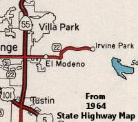 As defined on July 1, 1964, there was a section (3), from Route 55 near
Orange to Irvine Park. Before 1964, this section was LRN 182 (based on
number, defined in 1933). This section was deleted in 1965 by Chapter
1372, and had existed since at least 1957. The routing looks to be along
Chapman, and later became part of County Sign Route S18 in 1970 when County Sign Route S18 was created.
As defined on July 1, 1964, there was a section (3), from Route 55 near
Orange to Irvine Park. Before 1964, this section was LRN 182 (based on
number, defined in 1933). This section was deleted in 1965 by Chapter
1372, and had existed since at least 1957. The routing looks to be along
Chapman, and later became part of County Sign Route S18 in 1970 when County Sign Route S18 was created.
Notably the relinquished portion of Route 22 east of CA 55 to Irvine Park
was shown as retained on the 1966 Division of Highways Map. This routing
was likely retained in interim until Route 22 reached Route 55 via the
extension of the Garden Grove Freeway.
(Source: Gribblenation Blog (Tom Fearer), "California State Route 22 the Orange Crush of the Garden Grove Freeway", 2/22/2022)
Pre 1964 Signage HistoryThis segment was not part of Signed Route 22 until 1964.
 Classified Landcaped Freeway
The following segments are designated as Classified Landscaped Freeway:
| County | Route | Starting PM | Ending PM |
| Orange | 22 | T0.15 | R1.74 |
| Orange | 22 | R1.92 | R5.45 |
| Orange | 22 | R5.59 | R9.87 |
| Orange | 22 | R9.94 | R11.42 |
 Exit Information Other WWW Links
 Statistics
Overall statistics for Route 22:
NamingSegments (1) and (2) are named the "Garden Grove Freeway". It was named by the State Highway Commission. The first freeway segment opened in 1964; the last in 1967. It was named by location.
 Pre-1964 Legislative Route
The route that was to become [LRN 22] was defined in the 1909 First Bond Act as running from San Juan Bautista to Hollister. In the 1919 Third Bond Issue, a segment from Pacheco Pass Road into Hollister was added to the route. In 1933, it was extended further by the addition of segments from the "Coast Road near Castroville to [LRN 2] near Prunedale", and from "[LRN 22] near San Juan Bautista to [LRN 2] near The Rocks". In 1935, the route was codified into the highway code as:
The portion from LRN 2 to Hollister was considered a primary route. This definition remained until the 1963 "great renumbering".
Signage on the route was as follows:
© 1996-2020 Daniel P. Faigin.
Maintained by: Daniel P. Faigin
<webmaster@cahighways.org>.
 Route 21
 Route 23