
 California Highways:
Click here for a key to the symbols used. An explanation of acronyms may be found at the bottom of the page.
 Routing
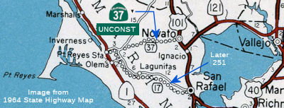 From Route 251 near Nicasio to Route 101 near Novato.
 Post 1964 Signage History
In 1963, this segment was defined to run from "Route 17 near Nicasio to Route 101 near Novato." In 1984, Chapter 409 changed "Route 17" to "Route 251". [On the map to the right, unconstructed Route 17 is what would later be Route 251]
 Pre 1964 Signage History
This portion of the routing was not part of the original definition of Route 37 in 1934. It was LRN 252 (defined in 1959) in 1963, but the routing was shown as "proposed, routing not determined".
 Status
 This segment is unconstructed. The traversable local routing is Point Reyes-Petaluma Road and Novato Blvd. The existing road is in the
vicinity of Stafford Lake, and is (a) inadequate and (b) unstable. There
are no plans for improvement.
This segment is unconstructed. The traversable local routing is Point Reyes-Petaluma Road and Novato Blvd. The existing road is in the
vicinity of Stafford Lake, and is (a) inadequate and (b) unstable. There
are no plans for improvement.
The 2013 Traversable Routings report notes that the traversable routing is Point Reyes-Petaluma Road and Novato Blvd. The existing road is in the vicinity of Stafford Lake. The road is not to State standards.
 Naming
This was to have been part of the "Point Reyes Freeway". The Pt. Reyes Freeway was one of many new routes created in the State Freeway and Expressway System, which was approved by the Legislature in 1959. This route has all but been killed by environmental concerns and costs. It would have connected with Route 251.
 Scenic Route
[SHC 263.4] Entire portion.
 From Route 101 near Novato to Route 80 near Lake Chabot via
the vicinity of Sears Point and via the former Sears Point Toll Road.
From Route 101 near Novato to Route 80 near Lake Chabot via
the vicinity of Sears Point and via the former Sears Point Toll Road.
Post 1964 Signage HistoryThis segment is unchanged from its 1963 definition.
Pre 1964 Signage HistoryOriginal Route 37 - US 101 to Ignacio
What was to become Route 37 started as LRN 8, defined as part of the 1909 First State Highway Bond Act as a highway routed between LRN 1 in Ignacio (US 101) east to Cordelia by way of Napa at LRN 7 (US 40, later I-80). LRN 8 is first shown on the 1918 Division of Highways State Map. Starting from US 101 (LRN 1), LRN 8 was signed as Route 37 until the present Route 37/Route 121 junction. It then continued N signed as Route 37 (post-1964 Route 121) to Shellville, continuing easterly towards Napa cosigned as Route 12/Route 37 (post 1964 Route 121). From Napa S, it was cosigned as Route 12/Route 29 (present-day Route 221), until Route 29 diverged. LRN 8 continued signed as Route 12 to Cordelia, where it joined with US 40 (LRN 7).
In 1934, Route 37 was signed along the route from Jct. US 101 (approx 037 MRN R11.346) near Ignacio to Jct Route 28 near Monticello, via Napa. The portion of this route between US 101 (LRN 1) and 7 mi NE of Ignacio (i.e., the current junction with Route 121) was LRN 8 defined in 1909.
Route 37 then continued along the current Route 121 routing to Route 128 (originally Route 28) as LRN 8 (to Route 29 in Napa) and LRN 6 (Napa to Route 128). This segment was the original definition of Route 37 (i.e., between US 101 near Ignacio to Route 28 near Monticello, via Napa).
The July/August 1950 California and Public Works Guide discusses the
improvements of Route 37/LRN 8 on the Black Point Cut-Off between US 101
east to Route 48 at Sears Point. The improvement project expanded part of
Route 37/LRN 8 to a four lane expressway while at the same time eliminated
some of the higher grades that were a problem on the original highway. The
March/April 1958 California and Department of Public Works Guide discusses
the construction of the Petaluma Creek Bridge on Route 37/LRN 8. The new
Petaluma Creek Bridge would be completed in 1958.
(Source: Gribblenation Blog "California State Route 37; the Blood Alley of San Pablo Bay")
 In 1961, there was controversy regarding a proposed
freeway routing for Route 12 and Route 37 (today's Route 121) near Sonoma.
The State Highway engineer recommended the Modified P Route. This route
follows the existing highway from Sign Route 48 (now Route 37) to Sears
Point, passes W of the Schellville Airport and runs to the junction of
Sign Route 37 (now Route 121) and Route 12. That portion was not
contested. What was contested was the next portion, which runs W of Sonoma
from the site of A&B Market, the N route, and the Sangiacomo Orchards
parallel to Watmaugh Rd to Arnold Dr., where it would veer N at an
interchange and run between Arnold Dr. and existing Route 12 to a point E
of Glen Ellen where it comes back to parallel the existing Route 12. There
was a large amount of opposition to this route. It is unknown whether the
freeway routing was ever adopted, but as of 2023, the routing is still the
original non-freeway routing through Sonoma.
In 1961, there was controversy regarding a proposed
freeway routing for Route 12 and Route 37 (today's Route 121) near Sonoma.
The State Highway engineer recommended the Modified P Route. This route
follows the existing highway from Sign Route 48 (now Route 37) to Sears
Point, passes W of the Schellville Airport and runs to the junction of
Sign Route 37 (now Route 121) and Route 12. That portion was not
contested. What was contested was the next portion, which runs W of Sonoma
from the site of A&B Market, the N route, and the Sangiacomo Orchards
parallel to Watmaugh Rd to Arnold Dr., where it would veer N at an
interchange and run between Arnold Dr. and existing Route 12 to a point E
of Glen Ellen where it comes back to parallel the existing Route 12. There
was a large amount of opposition to this route. It is unknown whether the
freeway routing was ever adopted, but as of 2023, the routing is still the
original non-freeway routing through Sonoma.
(Source: Press Democrat, 9/28/1961, via Joel Windmiller, 2/1/2023)
Original Route 47 - Ignacio to US 40 (Sears Point Toll Road)
In 1921, the legislature authorized the Department of Engineering to "to
make an investigation and submit a preliminary report upon a proposed
state road with the necessary bridges connecting the city of Vallejo with
a point on the state highway near Sears Point in Sonoma County." This
roadway wasn't built as a State Highway but rather as Sears Point Toll
Road which opened to traffic in 1928 according to the Novato History
website. The Sears Point Toll Road was operated by Golden Gate Ferries
under the subsidiary Sears Point Toll Road Company. The Sears Point Toll
Road can be observed on the 1935 Division of Highways Map of Solano County
and Sonoma County.
(Source: Gribblenation Blog "California State Route 37; the Blood Alley of San Pablo Bay")
The California Highway Commission recommended the State purchase the
Sears Point Toll Road in late 1932. The purchase of the Sears Point Toll
Road required Naval approval due to the Mare Island Naval Shipyard being
located on the highway. The Sears Point Toll Road was purchased by the
State in late 1938. Ultimately the Sears Point Toll Road was incorporated
into the State Highway System as LRN 208 in 1939. LRN 208 became the first
iteration of what was Route 48 which was routed between Route 37 at Sears
Point east to US 40 in Vallejo. Route 48/LRN 208 first appear on the 1940
Division of Highways Map. (note that this was a reuse of the number 48,
previously used for the 1926-1935 US 48, which became part of US 50). A
September/October 1944 California Highway and Public Works Guide discusses
the difficulty in maintaining Route 48/LRN 208 during World War II due to
the high traffic into the Mare Island Naval Yard. A new bridge over the
Napa River is discussed but the project ultimately rejected in favor of
resurfacing the existing structure. An expansion of Route 48/LRN 208
eastward with a grade separation towards US 40 is discussed. This
expansion of Route 48/LRN 208 east of the Napa River to US 40 was the
genesis point of the present freeway grade of Route 37 in Vallejo.
(Source: Gribblenation Blog "California State Route 37; the Blood Alley of San Pablo Bay")
The portion of this route from 7 mi NE of Ignacio (present-day Route 121 junction) and I-80 (former US-40; LRN 7) was resigned from Route 48 to become part of Route 37 in 1964. This was LRN 208, defined in 1939.
StatusState Route 37/121 Operational Improvement Project (OIP) (04-Sol-37, PM 0.0/R7.4; 04-Son-37, PM 2.9/6.2; 04-Son-121, PM 0.0/0.2)
 The 2020 SHOPP, approved in May 2020, included the following NEW Mobility item of
interest: 04-Sonoma-37 PM 3.8/4.0 PPNO 2023H Proj ID 0418000281 EA 1Q480.
Route 37 near Novato, at the intersection with Route 121. Improve
traffic operations by modifying intersection. Programmed in FY23-24, with
construction scheduled to start in September 2024. Total project cost is
$11,241K, with $6,533K being capital (const and right of way) and $4,708K
being support (engineering, environmental, etc.).
The 2020 SHOPP, approved in May 2020, included the following NEW Mobility item of
interest: 04-Sonoma-37 PM 3.8/4.0 PPNO 2023H Proj ID 0418000281 EA 1Q480.
Route 37 near Novato, at the intersection with Route 121. Improve
traffic operations by modifying intersection. Programmed in FY23-24, with
construction scheduled to start in September 2024. Total project cost is
$11,241K, with $6,533K being capital (const and right of way) and $4,708K
being support (engineering, environmental, etc.).
(Source: 2020 Approved SHOPP a/o May 2020)
In May 2023, the CTC approved for future consideration
of funding the following project for which a Final Environmental
Impact Report (FEIR) has been completed: Route 37 in Sonoma County
(04-Son-37, PM 3.8/4.3). Improve traffic operations by modifying the Route 37 and Route 121 intersection, in Sonoma County. (PPNO 2911K) This project
is located on Route 37 from postmile 3.8 to postmile 4.3, in Sonoma
County. The Department proposes to improve traffic operations by modifying
the Route 37 and Route 121 intersection. The project is currently
programmed in the 2022 State Highway Operation and Protection Program
(SHOPP) for a total of $26,446,000, which includes Right of Way (Support
and Capital) and Construction (Support and Capital). Construction is
estimated to begin 2024-25. The scope, as described for the preferred
alternative, is consistent with the project scope as programmed by the
Commission in the 2022 SHOPP.
(Source: May 2023 CTC Agenda, Agenda Item 2.2c.(9))
In May 2023, the CTC approved the following SHOPP (2a)
and SB1 (2b) allocation for preconstruction project phases for
environmental, design and R/W support: $4,029,000. 04-Son-37 3.8/4.3. PPNO
04-2911K; ProjID 0422000181; EA 2Q20U. Route 37 Near Novato, from 0.1 mile
west to 0.4 mile east of Route 121. Improve traffic operations by
modifying intersection and extending the lane merge in eastbound
direction. Concurrent consideration of funding under Resolution E-23-70;
May 2023. PS&E $3,931,000; R/W Sup $98,000.
(Source: May 2023 CTC Agenda, Agenda Item 2.5b.(2a) #4)
In June 2023, the CTC approved the following project
for future consideration of funding (which seems to be the same, based on
the map, as PPNO 04-2911K/EA 2Q20U): 04-Sol-37, PM 0.0/R7.4; 04-Son-37, PM
2.9/6.2; 04-Son-121, PM 0.0/0.2. State Route 37 Sears Point to Mare
Island Improvement Project. Route 37 in Solano County and Route 37
and Route 121 in Sonoma County. Reconfigure the existing Route 37 highway
lanes from west of the Route 121 intersection to the Walnut Avenue
Overcrossing at Mare Island. The project would widen the Tolay Creek
Bridge; have four lanes (two full-time lanes in each direction); have
8-foot shoulders (except at Sonoma Creek Bridge, which would have 4-foot
shoulders); and would widen the Sonoma Creek Bridge. In each direction the
existing lane would be converted to a full-time High Occupancy Vehicle
(HOV) lane and the added lane would be a toll lane, in Solano and Sonoma
Counties. (EA 04-1Q761). The project is currently proposed for
$430,000,000 in total funding from various State and local programs, of
which $80,100,000 is committed in the 2022 State Highway Operation and
Protection Program (SHOPP) for Right of Way (Support and Capital) and
Construction (Support and Capital). Construction is estimated to begin
2025-26. A copy of the FEIR has been provided to Commission staff. The
project would result in both permanent and temporary impacts to listed
species and sensitive marsh and wetland communities, for which Findings
pursuant to CEQA were made. Avoidance, minimization, and mitigation
measures would reduce impacts to less than significant. These measures
include, but are not limited to, Worker Environmental Awareness Training,
Nesting Bird Protection, preconstruction surveys, wetland protection,
species monitoring, construction noise protocols, species surveys, and
wildlife relocations. Compensatory mitigation for listed species and
wetland impacts would offset potential direct and/or indirect impacts as
identified in the FEIR. As a result, a FEIR was prepared for the project.
(Source: June 2023 CTC Agenda, Agenda Item 2.2c.(5))
The 2020 SHOPP, approved in May 2020, included the following NEW Mobility
item of interest: 04-Sonoma-37 PM 3.9/4.1 PPNO 2025P Proj ID 0418000432 EA
2Q200. Route 37 near Novato, from Route 121 to 0.2 mile east of Route 121.
Improve traffic operations by extending the lane merge in eastbound
direction. Programmed in FY23-24, with construction scheduled to start in
September 2024. Total project cost is $18,132K, with $12,487K being
capital (const and right of way) and $5,645K being support (engineering,
environmental, etc.).
(Source: 2020 Approved SHOPP a/o May 2020)
According to Chris Sampang, as of June 2004, between Sears Point (approx 037 SON 3.987) and Mare Island (approx 037 SOL R7.475), all two-lane sections are now separated with a Jersey Barrier. East of Mare Island, the highway uses a temporary four-lane segment between Sonoma Boulevard (Route 29) and the east end of the Mare Island bridge.
Sears Point (037 SON 3.936) to Route 29 (037 SOL 4.858) - Capacity Increase / Climate Change
In February 2011, it was reported that a study was in progress exploring a capacity increase in the 2-lane segment between Sears Pt. Rd and Route 29. The road is built on a berm, and travels through multiple protected species habitats, migration passages, wetlands, tidal marshes, farmland being converted back to wetlands, rivers, creeks, and bay shore lands. The Study will look at different ways to both mitigate and avoid mitigation measures in this sensitive area before the project is initiated. Caltrans and UC Davis will, at the end of this and probably following studies, will respond to the ecology of the area in its design, hopefully both increasing road capacity, adding class I bike/ped access to connect the Class I SMART train trail (70+ miles from Larkspur to Cloverdale) and the N/S bike network being designed to connect the Vallejo Ferry terminal in the south with the town of Calistoga in the north (www.vinetrail.org), and increase the tidal action, deal with sea-level rise and restore the saltmarshes damaged by the berm. This will not only help restore the largest remaining SF Bay wetland area, but also deal with multi-modal transport. This study is funded by 1 of only 4 TRB grants given out nationally for this purpose. The grant application was submitted by Caltrans in partnership with the UC Davis Road Ecology Center.
In August 2015, it was reported that there are concerns
about the impacts of climate change on Route 37. Although Route 37 sits
mostly in Solano and Sonoma counties, Napa County is impacted by traffic
jams on the route. Of particular concern is the fact that during heavy
winter storms, Route 37, which sits on a low berm over marshland, can
flood, diverting traffic to other routes, including Route 12/Route 121 in
Napa County. With sea levels expected to rise, Route 37 faces an even more
watery future. Napa County transportation officials want to make certain
that predicted sea level rise and increasing congestion never make
crippling Route 37 delays and closures the new normal. Napa County
Supervisors Keith Caldwell and Mark Luce are among the local officials who
have attended Route 37 Stewardship Study meetings, a regional effort to
re-imagine Route 37. Among the ideas – turn part of Route 37 into
the “Napa-Sonoma Causeway” and maybe even make it a toll road.
Route 37 runs for 21 miles from I-80 in Vallejo to US 101 in Novato and
passes through no Napa County city. But a short section passes through
county boundaries. In addition, several miles run on berms that affect
tidal water flow to south county wetlands. Researchers predict sea level
rise will lead to more and more flooding closures on Route 37 over coming
decades, until sections are swallowed up for good, possibly by
mid-century. “The most defining issue for Highway 37 is its
vulnerability to flooding during heavy storms,” states a recent
Route 37 report released by Caltrans. “Flooding has repeatedly
occurred in the past, requiring closure of the roadway. With rising sea
levels, flooding events will likely grow more frequent.” A
long-standing idea is to widen Route 37 between Mare Island and Sears
Point to four lanes. Caltrans could dispense with berms that are at most a
few feet high and build a levee wide enough for more lanes and high enough
to hold back rising tides. But this area is marshland – some of it
Napa County marshland—that is home to rare species such as the salt
marsh harvest mouse. A plan to build a massive levee amid the Napa-Sonoma
Marshes Wildlife Area and San Pablo Bay National Wildlife Refuge could get
bogged down beneath endless environmental studies. Another idea is to
create the Napa-Sonoma Causeway. The berms would be replaced by an
elevated Route 37 that passes above rising tides, much as the Yolo
Causeway takes I-80 above floodwaters near Sacramento. Additionally,
changing the route to a causeway would allow for structural integrity and
it would allow the marsh to more naturally function. Removing the berms
would open up tidal influence in the area. That in turn would open up
habitat for fish, birds and wildlife in general. A Napa-Sonoma Causeway
might not even go along the present Route 37 route. The Mare
Island-to-Sears Point section could be built over San Pablo Bay and remove
traffic from the endangered species habitat of the marshes. However, a
Caltrans report said, while removing the existing Route 37 berm could
restore natural hydrology, adjacent marshlands could still face
challenges. Other factors such as privately maintained levees, sea level
rise, buried toxins and more frequent droughts could come into play.
Building a Route 37 causeway between Mare Island and Sears Point would
cost an estimated $1.6 billion to $2 billion, depending on the type of
causeway.
(Source: Napa Valley Register, 8/29/2015)
In September 2015, it was reported that Marin and other
North Bay counties are looking to develop a plan and financing to improve
the utilitarian and sometimes aggravating Route 37 between Novato and
Vallejo. Increasing traffic and sea-level rise are among the challenges
facing the state highway, which existed in its current footprint since the
1930s. While the Marin portion has two lanes in each direction, it narrows
to one lane each way just past Sears Point. That makes for heavy traffic
during commute hours and gets even worse when there are race car events at
Sears Point. Additionally, because it sits so close to the bay and
wetlands, the highway is also vulnerable to flooding during heavy storms,
which cause repeated closures. Two separate studies show Route 37 is
vulnerable to projected sea-level rise, making it more likely to
experience increased flooding and frequent repairs. The highway is also
affected by the continual settling of the roadway from unstable soil
beneath and heavy truck traffic, which can cause undulations on its
surface. The Route 37 interchange with US 101 in Marin is also an area for
improvement. In September 2015, Marin County joined Sonoma, Napa and
Solano counties to look at ways to provide fixes for the highway while
seeking funding sources. The counties signed a memorandum of understanding
to study Route 37 improvements. Widening two-lane sections to four lanes,
improving the road and making it flood-proof won’t be cheap. Some
estimates of an overhaul to the highway have topped the $1 billion mark.
There has been some suggestion that Route 37 become a toll road to help
pay for improvements.
(Source: Marin Independent-Journal, 9/22/2015)
In October 2015, it was reported that an alliance of
business interests is seeking to establish one of the few toll roads in
the Bay Area to widen and raise Route 37 between Novato and Vallejo. The
toll road plan is being pitched by United Bridge Partners, a private investment firm with headquarters in Foster City. The proposal would require a raft of county and state
agencies to sign off on the deal, as well as action by the Legislature to
authorize converting the highway to a toll road. But some officials see
that option as the only viable way to make improvements on Route 37, given
a lack of other transportation funds. United Bridge Partners proposes to
use a portion of the toll revenue for environmental work. A 2012
stewardship survey conducted by Caltrans and UC Davis concluded that
rising sea levels pose a threat to Route 37.
(Source: Press Democrat, 10/16/2015)
In January 2016, an explanation for the mysterious
mounds on Route 37 was published. Along this segment of Route 37 is a
strip of tidal wetlands that is located to the south, with the 50,000-acre
Napa-Sonoma Marsh complex is to the north. The Department of Fish and
Wildlife and other agencies and organizations are working to convert
former salt ponds to wetlands. That will provide habitat for shorebirds,
waterfowl, raptors, and provide nursery areas for juvenile fish from the
bay. The problem is that, over the years, the salt ponds sank below sea
level. To address this, a consortium of organizations has constructed
about 500 “marsh mounds.” When the new marshes are flooded,
the mounds block the wind, build up sediment as tides push against them,
and create microhabitats where native plants can get established.
(Source: SF Gate, 1/3/2016)
In February 2016, the results of the State Route 37
Integrated Traffic, Infrastructure and Sea Level Rise Analysis Report were
made available. The report notes that three alternatives were looked at,
one on a levee and two bridge options (box girder, slab bridge). All three
alternatives call for two traffic lanes each way, 10 foot outside
shoulders, and 17 foot inside shoulders. The 17 foot shoulders will allow
for a 12 foot lane and a 5 foot inside shoulder in the future. Costs range
from $770 Million for the levee, $3.1 Billion for the box girder, and $2.7
Billion for the slab bridge.
(Source: Andy3175 @ AAroads, January and February 2016; Study Report)
In May 2016, it was reported that a proposal has been
floated to alleviate tieups on Route 37 by adding an elevated toll road.
Specifically, United Bridge Partners wants to expand the oft-congested
section of Route 37 between Sears Point and Mare Island, restore wetlands
and do it decades sooner by charging tolls. Tolls and traffic snarls have
been a part of Route 37’s 88-year history. The Novato–Vallejo
connector route originally opened as a toll road in 1928. It was a graded
and graveled road (160 feet wide) following the wagon routes that wandered
among the man-made “islands” to Vallejo and the highways
beyond. It had been a long time coming. The money to accomplish this came
from a company called Golden Gate Ferries, an early transport system with
no connection to the future famous bridge and its ferry system. It took
three years to build the 10 miles. There were three drawbridges — at
Tolay Creek, Sonoma Creek and the Napa River at Mare Island. The toll was
35 cents, paid willingly by “autoists,” as the drivers were
known. The ceremonial opening of the toll road in July 1928 was a grand
occasion, attended by dignitaries from the four counties that shared
sections of the road. Exchange Bank president and Chamber of Commerce
leader Frank Doyle led the Sonoma County delegation and kept careful
notes. The toll road lasted just 10 years. Northern California, like the
rest of the nation, had motorized. As traffic increased, so did the
state’s participation. By the mid-1930s, it was clear that the State
Division of Highways would eventually add the toll road to its free,
tax-financed highway system; the state purchased it in 1938. Before a
concrete divider was installed more than decade ago, the roadway got the
nickname Bloody Alley because of a number of accidents. Though the section
west of the Route 121 intersection near Sonoma Raceway was widened and
upgraded to a four-lane highway, the eastward portion to Mare Island in
Vallejo remains two lanes and subject to traffic tieups during commute
hours and on big race days. Caltrans doesn’t have a Route 37
expansion project funded in its 2050 plan, so paying for the project by
tolls would solve traffic congestion much sooner. The plan calls for
buying the section of roadway from the state, building a two-lane span of
roadway from Sears Point and the Mare Island bridge, fixing the
intersections at both ends. The raised roadway with a bike lane would be
for eastbound traffic, and the existing roadway would be converted to
westbound lanes without a divider. As sea-level rise becomes a problem,
the existing roadway eventually would be replaced with a causeway to match
the eastbound lanes. The project would be funded by private investors with
no state or federal money. Tolls would be logged electronically by the
FasTrak system used on Bay Area bridges and express lanes, and tolls would
be comparable to those rates. Options for vanpools and discounted toll
transponders could be available for lower-income commuters.
(Source: North Bay Business Journal, 5/28/2016; SonomaNews,
6/24/2016)
In July 2016, it was reported that the State Route 37
Policy Committee voted to forward the unsolicited proposal from United
Bridge Partners to the state Department of Transportation for review and
comment. The committee is formed by transportation agencies from Napa,
Sonoma, Solano and Marin counties. While only a short section of Route 37
skirts Napa County, transportation officials in Napa see the highway as
being important to the local roads network. They say a flooded or
traffic-choked Route 37 sends more traffic detouring to major Napa County
roads. The State Route Policy Committee has a list of 63 questions, and
that number is growing. Among them—what are the toll revenue
assumptions and what would the company do if environmental reviews prove
more complex than envisioned. Committee members expressed concern that the
United Bridge Partners proposal only covers a segment of Route 37, not the
entire route. Plans also call for elevating a section farther to the west.
Still, they are interested.
(Source: Napa Valley Register, 7/9/2016)
In February 2017, it was reported that flooding in
January 2017 created doubts on projections for when climate change will
cause severe, perhaps catastrophic impacts on the major North Bay
thoroughfare. Route 37, one of the lowest-lying in California, has long
been threatened by climate change and rising sea levels, inadequate levees
and political waffling over who bears responsibility for maintaining and
upgrading the road. The 21-mile highway meanders across four counties
— Solano, Napa, Sonoma and Marin — traversing tidal
marshlands, rivers and creeks, and farmland where flooding presents a
threat to livelihoods. The January storms showed that climate change was
starting to overwhelm the system in places where the previous belief was
that there were 20 years of lead time. January floods forced Caltrans to
shut the highway between US 101 and Atherton Avenue in Marin County for
the better part of seven days, and to restrict traffic to a single
direction an additional five days, according to California Highway Patrol
data. The flooding on the highway was a result of the storms that caused
Novato Creek to swell while king tides blocked the water from flowing into
San Pablo Bay. That forced water onto the highway and closed a 4-mile
stretch, backing up traffic in the region. Previous research warned that
Route 37 could be regularly inundated by 2050 and fully underwater by
2100. Sea level has already risen by 8 inches along the California coast
and by 2100 may be 36 to 66 inches above present levels. Short-term,
Caltrans is exploring an $8-million emergency upgrade to the highway near
Novato Creek to try and minimize flooding, with hopeful completion in
2017. “There is a possibility to bring the pavement up just enough
to address the type of flooding we saw in January,” said Dan
McElhinney, Caltrans’ chief deputy district director for the Bay
Area, noting that the work would occur along a 1,200-foot stretch near
Novato Creek. Drainage pipes — which measure 18 and 24 inches
— also could be replaced and made bigger to handle more water.
Additional pumping and a barrier also would help, he said. Agency land
surveyors are at work along Route 37 and have reported that the westbound
lanes sit lower than the eastbound lanes because of settling over the
years. In some areas, the roadway has dropped as much as 2 feet. Long
term, the entire highway is at risk for submerging under a predicted sea
level rise of 6 feet by the end of the century. That has prompted a hard
look at creating an elevated causeway for Route 37 along the Sonoma and
Solano segments. That work also would widen the road from two to four
lanes. While the Marin portion has two lanes in each direction, it narrows
to one lane each way just past Sears Point. Preliminary cost estimates for
the work range from $1.2 billion to $4.3 billion. To put that in
perspective, $1.2 billion has been spent on widening US 101 since 2001,
and the work is not yet done. Toll roads are another option. United Bridge
Partners, a private investment firm with headquarters in Foster City, has
proposed building a four-lane causeway between Sears Point and Vallejo,
where there are now just two lanes, and to pay for the expansion using
tolls. But more than a year after the proposal was made public, the effort
appears stalled.
(Source: Press Democrat, 2/2/2017; MarinI-J,
2/2/2017)
In April 2017, it was reported that a group of agencies
exploring solutions to flooding and traffic on Route 37 has funded a study
anticipated to identify actual projects that can be built along the
21-mile roadway. But with construction funds lacking, officials are unsure
when any of the future work might take place. The Sonoma County
Transportation Authority on Monday chipped in $30,000, the final piece of
funding for the Route 37 feasibility study. Other transportation agencies
in Marin, Napa and Solano counties paid similar amounts while the
Metropolitan Transportation Commission funded the bulk of the $1 million
study by contractors Kimley Horn and AECOM. The feasibility study is
expected to be completed by around the end of 2017, and will look at the
impacts of sea level rise and traffic alleviation, including drainage and
shoreline improvements, levee improvements and raising the roadway, said
James Cameron, director of projects and planning at the SCTA.
(Source: Petaluma Argus-Courier, 3/30/2017, via North Bay Business Journal)
In July 2017, it was reported that local transportation
leaders heard from the experts that elevating Route 37 above rising sea
levels is financially possible—if travelers pay a toll. The
21-mile-long highway runs from Vallejo to Novato through the Napa-Sonoma
marshes. Estimated costs to elevate the road on a levee or causeway range
from $1 billion to $3.4 billion in 2022 dollars, with costs rising in
subsequent years. A $6 toll could pay for a $1 billion project. A $7 toll
could pay for a $2.6 billion project. Another option is to do no tolling
and pay for an elevated Highway 37 through traditional, public highway
funding sources, but that could delay the fix until 2088. A U.C. Davis
study predicts much of the road will be underwater by then. Local
officials expect that, should a toll become a reality, some people will
take a detour to avoid it. That detour would bring more traffic to already
congested Route 29 and Route 121 in southern Napa County.
(Source: Napa Valley Register, 7/21/2017)
In December 2017, it was reported that the
Transportation Authority of Marin was awarded gas tax dollars to
“develop an action plan to address ongoing and projected flooding
issues from increased storm flows and sea level rise in the east-west
transportation corridor through the Novato Baylands,” according to
the California Transportation Commission, which awarded the grant
Thursday. Concurrently, the transportation agency is looking at how to
raise the roadway to eliminate flooding. About 40,000 vehicles a day use
Route 37, records show. Caltrans (California Department of Transportation)
made more than $5 million in emergency repairs and upgrades at the
approaches to the Novato Creek Bridge, where a private levee breach
occurred during king tides and steady rains, combining to flood the
highway. But Caltrans has indicated that Route 37 could suffer further
flooding and potential closures in the area. A consultant is studying the
financing of Route 37 improvements for Marin, Sonoma, Napa and Solano
counties for the 21-mile highway. A Route 37 toll of up to $7 would be
necessary to expedite major flood-prevention projects on the road, a
consultant has told transportation officials. The Marin transportation
agency actually asked for $411,000 for the planning work for the Novato
area, but will find other dollars to complete the work, Steinhauser said.
The Marin money was among the first planning grants funded through the gas
tax — also known as Senate Bill 1 — to support local agency
efforts to plan more sustainable communities, reduce
transportation-related greenhouse gases and adapt for the effects of
climate change, according to Caltrans.
(Source: Napa Valley Register, 12/11/2017)
In July 2018, it was reported that a new vision for
rebuilding flood-prone, traffic-choked Route 37 calls for also turning the
surrounding wetlands of the Napa-Sonoma marshes into a Bay Area outdoor
nature attraction as famous as Muir Woods. The group Common Ground says
this 46-square-mile area has no real identity, despite having state and
federal preserves. The team of architects, landscape architects, urban
designers, economists, ecologists and others wants the public talking
about “The Grand Bayway.” Concept paintings show people
walking and biking on boardwalks amid wetlands and sloughs as pelicans and
other birds fly nearby. An existing, low-key trailhead at the end of
Buchli Station Road in Napa County’s Carneros area is depicted as a
bustling place with an excursion train dropping off hikers. Route 37 would
be The Grand Bayway front door, but not the Route 37 of today. The new
road might be on a 20-foot-high causeway that snakes gracefully through
the wetlands, something that Leader said could be a signature feature like
the Golden Gate Bridge or Bay Bridge. One of the grander ideas is to have
an elevated walkway crossing above the elevated Route 37, perhaps some 30
feet in the air, allowing for a hike or bike ride with sweeping Bay Area
views. Common Ground and its The Grand Bayway proposal was one of nine
projects recently unveiled by the Resilient By Design Bay Area Challenge
funded by the Rockefeller Foundation.
(Source: Napa Valley Register, 7/21/2018)
 In July 2018, it was also reported that another idea to
save Route 37 along San Pablo Bay from predicted sea level rise is moving
a section north to drier land along a new route through American Canyon
and rural southwest Napa County. The Napa County option would mean
combining the 40,000 autos using Route 37 daily with the 45,000 autos
using Route 29 daily through the city of American Canyon. American Canyon
is already a notorious traffic chokepoint in Napa County. However, that
option looks to be a long shot. Transportation officials usually talk
about keeping the Route 37 section from Vallejo to Sears Point along the
same route and elevating it on an embankment or causeway. At a July 20
meeting, the State Route 37 Policy Committee of Caltrans and regional
officials touched on the northern inland route option through southern
Napa and Sonoma counties. Route 37 from Vallejo would head north along
Route 29 through American Canyon. It would cut west following the lightly
traveled Sonoma-Marin Area Rail Transit train tracks through the Carneros
region. It would take Route 121 south to Sears Point and rejoin the
existing Route 37 alignment west to US 101. The idea received a cold
reception from the Route 37 committee. But there are benefits to a Napa
County alignment. The present-day Route 37 passes through marshes skirting
San Pablo Bay. This is an area with state and federal wildlife preserves
and rare species ranging from the salt marsh harvest mouse to the
California clapper rail. Moving the highway to Napa County would remove it
from an ecologically sensitive habitat, said a report by Common Ground, a
group that has designed a vision for the area called the Grand Bayway.
That really unleashes all the tidal dynamics that would be key to the
marsh complex. A Napa County alignment could be a less expensive option
than building a causeway along the current Route 37 route. Sixty-three
percent less of the highway would go through refuges, the Common Ground
report said. Still, Common Ground called itself “alignment
agnostic.” The many paintings of Grand Bayway possibilities in the
report show Route 37 on a causeway along the present alignment, not in
Napa County. Another alternative alignment for Route 37 involves shifting
it to the south. The highway would cross San Pablo Bay on a bridge,
removing the highway from the marshes. Options for the existing alignment
have expanded beyond either an embankment or causeway to include a
combination of both. Sections of embankments would make it easier to
provide ways for people to reach public access areas in the wildlife
preserves. The goal is to complete an analysis of the alternatives by the
end of the year. The environmental study phase of the Route 37 project
should begin early next year.
In July 2018, it was also reported that another idea to
save Route 37 along San Pablo Bay from predicted sea level rise is moving
a section north to drier land along a new route through American Canyon
and rural southwest Napa County. The Napa County option would mean
combining the 40,000 autos using Route 37 daily with the 45,000 autos
using Route 29 daily through the city of American Canyon. American Canyon
is already a notorious traffic chokepoint in Napa County. However, that
option looks to be a long shot. Transportation officials usually talk
about keeping the Route 37 section from Vallejo to Sears Point along the
same route and elevating it on an embankment or causeway. At a July 20
meeting, the State Route 37 Policy Committee of Caltrans and regional
officials touched on the northern inland route option through southern
Napa and Sonoma counties. Route 37 from Vallejo would head north along
Route 29 through American Canyon. It would cut west following the lightly
traveled Sonoma-Marin Area Rail Transit train tracks through the Carneros
region. It would take Route 121 south to Sears Point and rejoin the
existing Route 37 alignment west to US 101. The idea received a cold
reception from the Route 37 committee. But there are benefits to a Napa
County alignment. The present-day Route 37 passes through marshes skirting
San Pablo Bay. This is an area with state and federal wildlife preserves
and rare species ranging from the salt marsh harvest mouse to the
California clapper rail. Moving the highway to Napa County would remove it
from an ecologically sensitive habitat, said a report by Common Ground, a
group that has designed a vision for the area called the Grand Bayway.
That really unleashes all the tidal dynamics that would be key to the
marsh complex. A Napa County alignment could be a less expensive option
than building a causeway along the current Route 37 route. Sixty-three
percent less of the highway would go through refuges, the Common Ground
report said. Still, Common Ground called itself “alignment
agnostic.” The many paintings of Grand Bayway possibilities in the
report show Route 37 on a causeway along the present alignment, not in
Napa County. Another alternative alignment for Route 37 involves shifting
it to the south. The highway would cross San Pablo Bay on a bridge,
removing the highway from the marshes. Options for the existing alignment
have expanded beyond either an embankment or causeway to include a
combination of both. Sections of embankments would make it easier to
provide ways for people to reach public access areas in the wildlife
preserves. The goal is to complete an analysis of the alternatives by the
end of the year. The environmental study phase of the Route 37 project
should begin early next year.
(Source: Napa Valley Register, 7/28/2018)
In February 2019, it was reported that the Sonoma
County Transportation Authority signed onto the partnership that includes
the transportation agencies of the four counties plus Caltrans and the Bay
Area Toll Authority, who are planning vast changes to the Route 37 in
response to the risk from climate change. The first fixes will be
completed within the next seven years, officials say, and the new formal
partnership defines the roles various agencies will play and sets the
process in motion. During the preliminary work, the study group broke the
route into three distinct segments: the four-lane flood-prone stretch from
US 101 to Sears Point; the narrow two-lane stretch from Sears Point to
Mare Island that is plagued with congestion and also susceptible to sea
level rise; and the four lanes from Mare Island to I-80, with bottlenecks
and outdated interchanges. The middle segment, from Sears Point to Mare
Island, was identified as the top priority. Fixes are already in the works
to temporarily relieve traffic, although officials say the final solution,
which could drastically alter the route’s alignment, is still
decades away and could cost several billion dollars. In the meantime,
officials are using $100 million in expected new Bay Area bridge toll
money to design the first projects. According to planning documents, the
first construction project will be a new roundabout to replace the current
traffic signal at Route 37 and Route 121 near Sonoma Raceway. The $30
million project should take seven years to complete, according to the
documents. At the same time, another project could expand the capacity of
the current two-lane segment from Sears Point to Mare Island by adding a
flexible third lane during peak commute times. Using the existing right of
way, the extra lane could be added with either a movable median barrier,
like the one on the Golden Gate Bridge, or a shoulder running lane, like
the expandable third lane on the Richmond-San Rafael Bridge. Those
improvements are expected to cost as much as $150 million and be completed
by the end of 2025, the planning documents estimate. The ultimate
solution, which accounts for sea level rise, includes some radical
concepts and is not planned to start until at least 2040. Plans range from
raising the existing roadway onto a combination of embankments and
causeways to drastically shifting the route inland so that it parallels an
existing rail line. The most revolutionary design would build a straight
bridge over San Pablo Day directly from Novato to Vallejo, bypassing the
shoreline entirely.
(Source: Argus Courier, 2/11/2019)
In March 2019, it was reported that Steve Heminger, the
departing executive director of the Bay Area Toll Authority, requested its
oversight committee refer a memorandum of understanding to Caltrans and
four North Bay county transportation agencies recommending a shift of
oversight on future improvements for this often-congested and flood-prone
corridor from San Francisco Bay Area's Metropolitan Transportation
Commission to BATA. This shift, which on paper appears to be a
bureaucratic shuffle, could prove important, officials said, because it
shifts oversight from a planning agency to BATA, a collector of tolls from
Bay Area bridges, with exception of the Golden Gate Bridge. Given Route 37
falls under California Department of Transportation (Caltrans) authority,
and involves several county transportation committees, having a point
agency focused on financing and revenue sourcing responsible for
delivering road upgrades could prove vital to getting years of
construction projects off drawing boards. What could then be on the
horizon are more funding resources for a series of phased improvements to
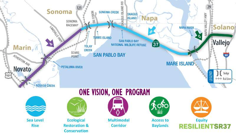
the roadway from Novato to Vallejo included in the Resilient SR 37
program. One of these improvements – raising the road – could
get a boost. BATA has toll income to leverage for financing, and it
already collects tolls so authorities could get the state to design the
project to include a bridge, or elevated causeway, and then collect tolls
under BATA authority. Sonoma County District 2 Supervisor David Rabbitt
said RM 3, a bold, Bay Area region wide traffic relief plan approved by 55
percent of the voters in June 2018, has $300 million allocated to four
counties that they can apply to help fund local priorities. Some $100
million is currently allocated from RM3 for Route 37, including $3 million
to TAM for a levee evaluation study, $15 million to SAT for an
interchange, $24 million to SCTA for the Route 37/Route 121 interchange
and $58 million to TAM and SCTA for Route 37 Segments A & B planning.
Within three to five years, a highway roundabout could be built where
Route 37 meets Route 121 that would ease congestion by allowing continuous
access from all directions with no stops. Another intermediate step would
extend two lanes eastbound. Other options include three lanes using a
mobile moveable barrier to switch traffic morning and evenings, or four
lanes as part of a raised causeway. On the eastern end of the highway, a
Mare Island interchange is proposed with a Westbound lane drop extension
and ramp metering system.
(Source: North Bay Business Journal, 3/4/2019)
In March 2019, it was reported that agencies trying to
fix flooding problems on Route 37 hope to get legislation that would turn
the stretch from Sears Point to Mare Island into a state-owned toll
bridge. The project has been dubbed the “Resilient SR 37
Program.”The legislation could result in the “bridge”
being created without the need to go to the voters for approval on the
toll, according to a Metropolitan Transportation Commission spokesman.
Near-term improvements can be completed over the next three to five years
with approved bridge toll funds, the regional agency reports. These
include installing a multiple-lane roundabout to eliminate the traffic
signals at the intersection of Route 37 and Route 121; extending the
two-lane eastbound configuration farther beyond Sears Point; and upgrading
the westbound access from Mare Island in Vallejo. The Transportation
Authority of Marin is teaming with public and private property owners to
shore up vulnerable dikes and levees in Novato, the Metropolitan
Transportation Commission reports. Options for intermediate-term
improvements over the next five to seven years center on the section
between Sears Point and Mare Island and could include either a three-lane
configuration with a moveable median barrier – similar to the one
used on the Golden Gate Bridge – or making this segment a four-lane
highway. That option would mean the loss of shoulders along much of that
stretch.The project would also allow for restoration and enhancement of
sensitive wetlands and natural habitats.
(Source: Solano Daily Republic, 3/20/2019)
In June 2019, it was reported that the California
Transportation Commission approved the $10 million study this week in a
unanimous vote during its meeting in Sacramento. North Bay representatives
and transportation officials had urged Caltrans to begin the studies after
the four-mile section between Novato and Black Point Bridge was closed
twice due to flooding this winter and in years past. Officials lauded the
commission’s decision this week, but acknowledged it only addresses
a small section of the flood-plagued corridor that stretches between
Novato and Vallejo. Caltrans will focus its study on the nearly four-mile
section of highway between Novato and the Black Point Bridge. This section
has flooded twice since 2017 including this winter, causing the highway to
close for days or weeks at a time and creating headaches for commuters.
Potential fixes that Caltrans will study include raising the highway on an
embankment of about 17 or 18 feet or raising the highway on a
causeway-type structure, according to Transportation Authority of Marin
Executive Director Dianne Steinhauser. The environmental and engineering
studies are expected to take 24 to 36 months to complete. Improvements
will cost between $580 million to $850 million depending on the option,
according to McGuire. Another $100 million in bridge toll revenues from
Regional Measure 3 are slated to be used to begin work on these
improvements. The funding is being held in escrow until ongoing legal
challenges against Regional Measure 3 are resolved. Still, the funding
would only cover a sliver of the estimated $3 billion needed to improve
the entire highway, according to the Transportation Authority of Marin.
One idea to pay for these fixes is to impose a new toll on Route 37
commuters.
(Source: Marin I-J, 6/27/2019)
In June 2019, the CTC approved the following SHOPP
amendment, related to the above news items: 04-Mrn-37 R11.2/13.7 PPNO 5200
ProjID 0419000376. Route 37 In Novato, from Route 101 to 0.1 mile west of
Atherton Avenue. Reconstruct the roadway to address sea level rise and
recurrent flooding. PA&ED $10,000K; PS&E* $15,000K; R/W
Sup* $2,000K; Con Sup* $16,900K; R/W Cap*
$19,700K; Const Cap* $820,500K; Total $884,100K (* =
Not Programmed). BC: 5/1/2027
(Source: June 2019 CTC Minutes, Agenda Item
2.1a.(1) Long Lead Item 2)
In June 2019, the CTC approved the following SHOPP
support phase allocation related to the amendment above: $10,000,000
04-Marin-37 R11.2/13.7 PPNO 9819 ProjID 0419000376 Route 37 In Novato,
from Route 101 to 0.1 mile west of Atherton Avenue. Reconstruct the
roadway to address sea level rise and recurrent flooding. (Long Lead
Project) PA&ED $10,000,000 (Concurrent consideration of funding under
Resolution E-19-69; June 2019.) (As part of this allocation request, the
Department is requesting to extend the completion of the R/W Sup phase an
additional 39 months beyond the 36 month deadline.) (Concurrent amendment
under SHOPP Amendment 18H-010.) (Concurrent SB 1 Baseline Agreement
approval under Resolution SHOPP-P-1819-13B.) (Concurrent R/W Cap
allocation under Resolution FP-18-82.)
(Source June 2019 CTC Minutes, Agenda Item
2.5b.(2a) Item 18)
In September 2019, it was reported that Caltrans has
received $10 million from the California Transportation Commission to do
the necessary environmental and engineering studies for a longer-term fix
to a segment of Route 37 between US 101 and Black Point. Caltrans is
looking at the possibility of raising the roadway 15 feet or installing a
viaduct or causeway. They are also looking at extending that and taking it
all the way from Black Point to Sonoma Raceway. Caltrans will seek
additional funding from the California Transportation Commission in early
2020 to do the environmental studies for that second phase of the project.
It would take until 2023 to complete the environmental studies and
estimated the earliest construction could begin would be 2025. The MTC
Executive Ddirector for Operations indicated that MTC's plans for reducing
congestion on Route 37 between Sonoma Raceway and Mare Island include
adding a third lane that would alternate as a second lane traveling in the
direction of rush hour traffic, similar to the lane conversion scheme on
the Golden Gate Bridge. MTC is also looking at options for raising the
roadway with fill and installing causeways on sections of this segment as
well. MTC believes that tolls similar in price to the ones on existing Bay
Area bridges will be necessary to generate the millions of dollars needed
to complete these projects.
(Source: Marin I-J, 9/27/2019)
In December 2019, it was reported that the California
Coastal Conservancy voted unanimously for a $1.5 million stage grant for a
project aimed at reducing flooding near Route 37 and bolstering nearby
wetlands near Novato. The funding permits the Marin Flood Control and
Water Conservation District to perform the enhancement work on 136 acres
of wetlands in Simmons Slough, as part of a larger effort to restore
habitat in the bay lands and manage flood control, manage water
management. The Department of Water Resources grant will be used to
replace and repair culverts, stabilize banks, install weirs, replace a
failed diesel pump station with a fully electric pump and enhance wetland
habitat. The work will allow the area to retain more water during the wet
season. While the project won’t address issues such as levee
breeches that occurred in early 2019, county senior engineer Roger
Leventhal said it will help drain flooded areas of the watershed more
quickly once a breach is fixed. In turn, this will reduce flood waters
from ponding over larger periods, he said. The project also includes
restoration of three acres of seasonal wetlands owned by Marin Audubon,
which was cut off from the bay by the construction of Highway 37 and
levees along Novato Creek. The organization plans to begin planting
wetland plants starting in January and February, with the habitat
restoration benefiting migratory birds. The entire project will costs
about $2.2 million, with the remainder being covered by the Marin County
Flood Control and Water Conservation District’s Zone 1. Construction
is expected to begin in spring or summer of 2020 depending on the
contractor bidding timeline.
(Source: Marin I-J, 12/20/2019)
In January 2020, the CTC amended the scope of this
project in the long-lead time SHOPP: 04-Mrn-37 R11.2/13.7 R11.2/14.6.
PPNO 5200. ProjID 0419000376. EA 4Q320. In and near Novato, from Route 101
to 0.1 mile west of Atherton Avenue Sonoma County line;
also in Sonoma County on Route 37, from Marin County line to Route 121
(PM 0.0/3.9). Reconstruct the roadway to address sea level rise
and recurrent flooding. According to the amendment, after discussions with
the stakeholders and resource agencies, a decision was made to extend the
project limits by 4.8 miles to provide a facility more resilient to
climate change. An additional four years are necessary to enable further
studies of the new segment.
(Source: January 2020 CTC Agenda, Agenda Item
2.1a.(1f) Item 1)
In February 2020, it was reported that Route 37 may
become a toll road under a new state bill introduced in February 2020.
Toll revenues would be used to fund major rebuild and flood protections of
the busy East Bay-North Bay connector in preparation for sea level rise
and flooding impacts. The bill would implement the first major climate
change adaptation project in the entire Bay Area road system.
Additionally, the tolls would provide funding to bolster the surrounding
wildlife habitat and address congestion issues that would only grow worse
over time. Route 37 has already been impacted by flooding caused by heavy
storms and levee breeches in recent years, including closures in early
2019. Sea level projections show flooding would exacerbate over time with
major sections of the 21-mile highway projected to be under water by the
end of the century. Much of the details of the bill and the tolls will
need to be hammered out in the coming months. The toll price could be
similar to tolls on Bay Area bridges at a range of $5 to $6, which could
raise a conservative estimate of $650 million over 20 years. Given that
project estimates could range in the $3 billion to $4 billion range, the
authority would work to leverage its toll revenue to obtain state and
federal funds.
(Source: Marin I-J, 2/21/2020)
The 2020 SHOPP, approved in May 2020, included the
following Carryover Long Lead Multiple Objective item
of interest (carried over from the 2018 SHOPP): 04-Marin-37 PM R11.2/14.6
PPNO 1490P Proj ID 0419000376 EA 4Q320. Route 37 in and near Novato, from
Route 101 to Sonoma County line; also in Sonoma County on Route 37, from
Marin County line to Route 121 (PM 0.0/3.9). Reconstruct the roadway to
address sea level rise and recurrent flooding. Note: Studies for long-term
improvements to address the sea level rise and recurrent flooding, complex
environmental studies including lengthy coordination with multiple
agencies, and substantial coordination with railroad, utility companies
and adjacent owners. Programmed in FY30-31, with construction scheduled to
start in May 2031. Total project cost is $884,100K, with $840,200K being
capital (const and right of way) and $43,900K being support (engineering,
environmental, etc.). Only the PA&ED allocation of $10,000K is
authorized in the 2020 SHOPP.
(Source: 2020 Approved SHOPP a/o May 2020)
In July 2020, it was reported that a state appeals
court has upheld a lower court’s ruling allowing a 2018
voter-approved toll hike on state-owned bridges in the Bay Area to stand,
a move that could finally unleash up to $4.5 billion to pay for regional
road and transit upgrades, including projects tied to US 101, SMART and
Route 37 in the North Bay. A three-judge panel of the First District Court
of Appeal in San Francisco issued its decision on Monday, siding with the
Bay Area Toll Authority following oral arguments in late May. A planned
appeal to the state Supreme Court, however, could further stall the
funding and delay dozens of projects that depend on it. The ruling goes
against the Howard Jarvis Taxpayers Association and a Contra Costa
resident, who together sued over Regional Measure 3, arguing it was a tax
that needed a two-thirds majority and not a simple majority when 55% of
voters approved it two years ago. But the appellate court upheld the
ruling of a San Francisco Superior Court judge, who in April last year
found the toll increases represented a user fee, not a tax. Tim Bittle,
director of legal affairs for the taxpayers association, said the group
intends to appeal. It is not yet clear, Goodwin said, whether the
collected revenues from the three scheduled $1 toll hikes, which started
in January 2019, could be disbursed before the state’s high court
takes up the case, if it does. The three Sonoma County projects guaranteed
funding under Regional Measure 3 include: $120 million toward completing
the US 101 Sonoma-Marin Narrows lane-widening; $100 million for Route 37
improvements; and $40 million for SMART’s Windsor extension, which
is slated to be finished by the end of 2021. Without those funds, however,
none of the projects — nor the dozens of others in the Bay Area
— can proceed.
(Source: Press Democrat, 6/30/2020)
In April 2021, it was reported that a three-pronged
effort is being pursued to resolve the recurring problems along a 21-mile
section of Route 37 from US 101 in Novato to Mare Island and I-80
including short term, interim and permanent remedies. These were presented
at a virtual town hall in mid-April 2021. The Resilient 37 Executive
Steering Committee’s three-pronged plan is as follows:
(Source: North Bay Business Journal, 4/16/2021)
In addition, there are flood reduction projects
underway along the highway. One reduces flooding through CalTrans efforts
from US 101 to Sears Point that include new paving and repairing low
spots, building concrete walls, adding drains, controlling water with
flood gates, dams and pumps, as well as having inflatable barriers.
Several of these improvements have already been made. Officials are
considering a potential initiative that involves removing the median fixed
barrier and using a movable barrier as an interim solution to add a
carpool lane for the east and west bound lanes during morning and evening
commutes from Sonoma Raceway to Mare Island. A study is also being
conducted for a way to raise the roadbed from US 101 to Sears Point.
Another option would also allow the shoulder to be used as a carpool lane
to create four lanes, while another possible approach would build a
four-lane highway with carpool lanes during peak periods. To help address
climate change, encourage ride sharing and micro transit as well as make
express bus transit feasible on the corridor, all options being considered
would add carpool lane(s). Caltrans and the MTC are leading studies on a
long-term objective that would lift the corridor out of the marshlands and
lead to the construction of a bridge over San Pablo Bay. Alternative road
alignment(s) away from marshland are also on the table for consideration
as options for the existing route. Funding this overall
multi-billion-dollar improvement project will most likely require tolls on
the corridor section through the marshland adjusted for users based on
their income levels. Such tolls are seen as a matching incentive to
attract state and federal funds.
(Source: North Bay Business Journal, 4/16/2021)
In December 2021, it was reported that data presented
at the Oct. 7 State Route 37 Policy Committee meeting showed that a
possible Napa/Carneros rerouting for Route 37 has drawbacks. One proposed
solution is to elevate and widen the highway along its present route from
Vallejo to Novato through Solano, Sonoma, and Marin counties. Another is
to move the highway away from marshland to higher ground. The committee
was exploring places to relocate the western Route 37 segment in
Marin/Sonoma counties. But that involved considering the highway route as
a whole. Consulting firm T.Y. Lin International Group looked at the top 10
Route 37 commutes from origin to destination. A northern route that
included the Napa County Carneros area would increase vehicle miles
traveled by 12%. In addition, a northern route could increase congestion
on Route 12 through Jameson Canyon, on Highway 29 through American Canyon
and on other regional roadways as traffic patterns changed. Congestion can
lead to more greenhouse gas emissions. The Napa County route idea has been
around for several years, apparently to keep all options on the table.
Even in 2018, the idea received a cold reception from the State Route 37
Policy Committee.
(Source: Napa Valley Register, 12/6/2021)
In January 2022, the CTC amended this project in the
SHOPP as follows: 04-Mrn-37 PM R11.2/14.6. PPNO 04-5200; ProjID
0419000376; EA 4Q320. Route 37 In and near Novato, from Route 101 to
Sonoma County line; also in Sonoma County on Route 37, from Marin County
line to Route 121 (PM 0.0/3.9). Reconstruct the roadway to address sea
level rise and recurrent flooding. (Long Lead Project) Allocation changes:
Zero out everything but PA&ED (Environmental). Note: Remove funding
beyond the environmental phase for this long lead project. Future
phases will be programmed when the scope is well defined and input from
the regulatory agencies is available.
(Source: January 2022 CTC Agenda, Agenda Item
2.1a.(1f) #2)
In February 2022, it was reported that Caltrans has
unveiled new details of a plan to upgrade and eventually rebuild the Route 37 corridor. The discussion includes several options to rebuild or reroute
the highway, including raising the existing road, rerouting it farther
north and even building a new bridge across San Pablo Bay. While the
rebuild project would be decades out, Caltrans is also proposing a project
in the coming years to widen a bottlenecked section of the highway that
backs up traffic for more than an hour in some cases. Caltrans has
developed eight concepts for how it could reroute or rebuild Route 37 in
the coming decades. The options range from rerouting the highway to other
roads farther north; keeping the route by either elevating the highway or
building a new levee system; or building a new bridge across north San
Pablo Bay connecting Marin to Solano County. The plan also calls for
building a separated bike and pedestrian path along the new corridor as
well as integrating transit options such as bus routes, trains and
ferries. The study, set for completion in late summer or early fall, will
help narrow the options, which will then undergo a full environmental
review. To address traffic issues, Caltrans proposes to begin widening a
10-mile section of the highway from Sears Point to Mare Island in 2025.
The section bottlenecks from two lanes to one lane each, which increases
travel times by 30 minutes during the morning commute and up to 80 minutes
during the afternoon commute, according to the Metropolitan Transportation
Commission, the Bay Area’s top transportation planning agency. To
reduce travel time, Caltrans wants to add at least one carpool lane that
would also allow the potential for public transit buses to use the highway
for the first time. Caltrans outlined four construction options on
Wednesday that would cost between $256 million and $415 million and would
be paid for by tolling the highway. A draft environmental review of the
proposals is up for public review and comment. One option would add a
moveable barrier to the highway — similar to that used on the Golden
Gate Bridge — to shift the extra carpool lane during peak westbound
and eastbound commute hours. The project would cost an estimated $256
million, including an additional $2 million per year for maintenance and
staffing costs. The second option would be to add a third lane to the
highway, which would be shifted to the westbound or eastbound direction
based on peak commute times. This option would cost an estimated $306
million. The last two options would widen the highway to four lanes to add
a carpool lane in each direction. One option would have shoulders of only
4 feet, while the other option would have an 8-foot shoulder and would
widen the Sonoma Creek Bridge. This fourth option would also be the only
one to allow for bicycle access. These options would cost an estimated
$325 million to $415 million.
(Source: Mercury News, 2/4/2022)
In July 2022, it was reported that the state
Legislature and Gov. Gavin Newsom have allocated $30 million in the state
budget to begin planning for defenses against climate change for the area.
The budget adopted provides $20 million to begin designing flood
protections on Route 37 (04-Mrn-37 PM R11.2/14.6. PPNO 04-5200; ProjID
0419000376; EA 4Q320) and the Novato Creek Bridge (04-Mrn-37 0.0). Another
$10 million is for planning defenses for recurring flooding on US 101 that
blocks the only road in and out of Marin City (~ 04-Mrn-101 3.393). Route 37, the 21-mile link between I-80 and US 101 near Novato, is used daily by
nearly 50,000 commuters, many of them making their way to jobs in the
North Bay. The low-lying highway along the bay has regularly experienced
prolonged closures because of flooding. By 2040, sea-level rise threatens
to regularly inundate the corridor, making it virtually unusable,
according to Caltrans. Caltrans is studying several projects to overhaul
the road, including a complete rebuild or rerouting of the highway. One
nearer-term project is the rebuilding of the Novato Creek Bridge. The
bridge placement project is being studied as part of an environmental
review of a problematic 4-mile section of highway between Novato and the
Black Point Bridge. This section has flooded twice since 2017, including
in the winter of 2019, causing the highway to close for days or weeks at a
time. The study, which will include various design options, is set for
completion next year. Regardless of the option that is studied, the Novato
Creek Bridge will need to be replaced, and funding can be utilized for the
design costs of the Novato Creek Bridge, interim fixes and raising the
highway corridor in some of the most vulnerable sections. With respect to
the US 101 funding, Marin City has long dealt with US 101 flooding that
blocks the only access point in and out of the community during heavy
rains and high tides. The $10 million state allocation allows Caltrans,
the Transportation Authority of Marin and other project partners to begin
design work or environmental reviews for flood control projects. One
proposed project would elevate a section of a southbound US 101 lane and
the offramp at the Marin City exit. The project would also build a
700-foot floodwall between the highway and a stormwater pond near the
Gateway Shopping Center, as well as facilities to pump water from the pond
into Richardson Bay.
(Source: Marin I-J, 7/3/2022)
In September 2022, it was reported that Caltrans, in
order to keep traffic flowing decades from now, intends to build an
elevated road along Route 37 to combat rising water levels, which are
expected to eventually inundate the North Bay arterial. The proposed
project essentially stretches across the existing route along San Pablo
Bay and through Marin, Sonoma, Napa and Solano counties. It preserves
travel patterns, allows landward marsh migration and is resilient to sea
level rises, officials said in explaining its benefits. The concept was
one of 10 presented earlier this year, most of which were eliminated over
months of discussion with North Bay cities, agencies and organizations.
The eliminated concepts mostly suggested creating routes via existing and
new roads between US 101 in Sonoma and Marin counties and Route 29 in Napa
County. Other plans focused on bridge construction between Novato and
Vallejo. Caltrans officials announced the final plan during a Sept. 14
2022 public meeting about the rising water, which is expected to overtake
Route 37 by 2050. The favored plan also proposes the route have a 60 mph
speed limit, as well as two lanes in each direction with bicycle and
pedestrian paths. The plan is in its early stages and officials
haven’t identified a cost or funding source.
(Source: Sonoma Index Tribune/Press Democrat, 9/18/2022)
In February 2023, it was reported that State and local
transportation agencies announced a partnership agreement to implement
more pressing improvements to the highway while a longer-term solution to
the problem is hammered out. The partnership is between the California
State Transportation Agency, the California Natural Resources Agency, the
Metropolitan Transportation Commission, Caltrans District 4, the
California Department of Fish and Wildlife and the San Francisco Bay
Conservation and Development Commission. The group issued a statement that
said, "This agreement is the first step toward a re-envisioned Highway 37
that is resilient to sea level rise, protects critical marsh and tidal
habitats, reduces transportation inequities and incorporates bicycle,
pedestrian, transit and carpool options for travelers." The six
transportation and environmental entities have agreed to begin by widening
the highway along a 10-mile traffic bottleneck. At the same time, the
coalition agreed to begin initial work to plan for a proposed elevated
highway. The agreement also prioritizes projects to prevent regular
flooding of the highway near Novato. Agencies such as the Metropolitan
Transportation Commission and Caltrans say the elevated highway project
could require upwards of $8 billion in funding and significant planning
before it can be built. Caltrans estimates the widening project, which
would add a carpool lane in each direction between Sears Point and Mare
Island, would cost nearly $500 million. The project partners aim to begin
construction of the widening project in 2027. The widening will require
thousands of truckloads of sediment to be placed on protected wildlife
habitats that are home to endangered species. Proponents of the elevated
causeway project also said it would simultaneously be the largest wetland
restoration project on the West Coast by reopening the marshlands to tidal
influence, which is currently blocked by the highway.
(Source: CBS Bay Area, 2/9/2023; Marin I-J, 2/13/2023)
 On March 27, 2023, the CTC received an application from the Bay Area
Infrastructure Financing Authority, a joint powers authority that serves
as the infrastructure financing arm of the Metropolitan Transportation
Commission, to authorize a toll lane in each direction of the Route 37
corridor from Sears Point to the Mare Island interchange in Vallejo. This
portion of the corridor currently is a two-lane conventional highway. The
Route 37 Sears Point to Mare Island Improvement Project would reconfigure
the existing roadway to provide a tolled lane and a high-occupancy vehicle
lane in each direction. It also would introduce bus transit service along
the high-occupancy vehicle lane, establish an equity discount program for
the tolled lane, and include climate adaptation strategies to mitigate
flooding risks. The project is a partnership between the Metropolitan
Transportation Commission, the California Department of Transportation
(Caltrans), the Transportation Authority of Marin, the Sonoma County
Transportation Authority, the Solano Transportation Authority, and the
Napa Valley Transportation Authority. With Caltrans as the lead agency,
the environmental phase of the project was completed on February 9, 2023
pursuant to the California Environmental Quality Act and the National
Environmental Policy Act. AB 194 requires the Commission to find, at a
minimum, that the application meets six criteria. In addition, the
Commission’s guidelines, adopted in March 2016, strongly encourage
applicants to provide supplemental information regarding the project. AB
194 further requires the Commission to hold at least one hearing to
receive public comment on the application at or near the proposed
facility. On April 24, the Commission held a public hearing in Vallejo.
On March 27, 2023, the CTC received an application from the Bay Area
Infrastructure Financing Authority, a joint powers authority that serves
as the infrastructure financing arm of the Metropolitan Transportation
Commission, to authorize a toll lane in each direction of the Route 37
corridor from Sears Point to the Mare Island interchange in Vallejo. This
portion of the corridor currently is a two-lane conventional highway. The
Route 37 Sears Point to Mare Island Improvement Project would reconfigure
the existing roadway to provide a tolled lane and a high-occupancy vehicle
lane in each direction. It also would introduce bus transit service along
the high-occupancy vehicle lane, establish an equity discount program for
the tolled lane, and include climate adaptation strategies to mitigate
flooding risks. The project is a partnership between the Metropolitan
Transportation Commission, the California Department of Transportation
(Caltrans), the Transportation Authority of Marin, the Sonoma County
Transportation Authority, the Solano Transportation Authority, and the
Napa Valley Transportation Authority. With Caltrans as the lead agency,
the environmental phase of the project was completed on February 9, 2023
pursuant to the California Environmental Quality Act and the National
Environmental Policy Act. AB 194 requires the Commission to find, at a
minimum, that the application meets six criteria. In addition, the
Commission’s guidelines, adopted in March 2016, strongly encourage
applicants to provide supplemental information regarding the project. AB
194 further requires the Commission to hold at least one hearing to
receive public comment on the application at or near the proposed
facility. On April 24, the Commission held a public hearing in Vallejo.
(Source: May 2023 CTC Agenda, Agenda Item 4.3, 4.4)
As noted above, a requirement of the toll application
is that six criteria be demonstrated. (1) is that the proposed toll
facility will improve the corridor's performance by, for example,
increasing passenger throughput or reducing delays for freight shipments
and travelers, especially those traveling by carpool, vanpool, and
transit. Route 37 runs 21 miles, connecting US 101 in the west with I-80
in the east. The westernmost section from US 101 to Sears Point is a
four-lane expressway and the easternmost section from Mare Island to I-80
is a four-lane freeway. The middle section, which is the subject of the
project application, is a two-lane conventional highway. According to the
Bay Area Infrastructure Financing Authority’s application, two
bottlenecks form where the existing two lanes merge into one lane in both
the eastbound and westbound directions. Motorists experience significant
recurring traffic congestion and delays at these bottlenecks, with queues
extending 2.1 miles in the westbound direction in the morning and 4.7
miles in the eastbound direction in the evening. Maximum travel times are
60 minutes during the westbound morning period commute and 100 minutes
during the eastbound evening period commute. By 2045, under the no build
scenario, the Bay Area Infrastructure Financing Authority projects the
queues to increase to 23.4 miles westbound and 19.4 miles eastbound and
maximum travel times of 274 minutes for the eastbound morning commute and
323 minutes for the westbound evening commute. By 2045, after the proposed
project is completed, the eastbound peak period queue length would be 5.9
miles (a decrease of 17.5 miles) and the westbound peak period queue
length would be 4.3 miles (a decrease of 15.1 miles). Maximum travel times
during the peak period eastbound would be 97 to 101 minutes (a decrease of
173 to 177 minutes) and westbound would be 42 to 58 minutes (a decrease of
265 to 281 minutes). The application also documents substantial
improvements in the duration of congestion, hourly flows, total peak
period throughput, average delay, average speeds, vehicle hours of travel,
and vehicle hours of delay. Further, the project would allow for bus
transit service on the corridor between Vallejo and Novato that is not be
feasible without improved traffic flow.
(Source: May 2023 CTC Agenda, Agenda Item 4.3, 4.4)
The project also (2) needs to be in a regional
transportation plan ( Metropolitan Transportation Commission Plan Bay Area
2050 (Regional Transportation Plan, RTP ID# 21-T06-035)), (3) have
cooperation between the regional transportation agency and Caltrans
(support letters were submitted), (4) meet the requirements of Streets and
Highways Code Section 149.7, as amended by Assembly Bill 194. This
contains requirements for tolling applicants approved by the Commission
regarding matters such as law enforcement for the toll facility; the use
of toll revenues; the collection of toll revenues; and bond financing. The
last two requirements are (5) a complete project initiation document for
the proposed toll facility, and (6) a complete funding plan for
development and operation of the toll facility. All of these were
provided.
(Source: May 2023 CTC Agenda, Agenda Item 4.3, 4.4)
In April 2023, it was reported that the California
Transportation Commission was holding public hearings about a proposal
that would start charging tolls on Route 37. If approved, the toll would
go into effect for a 10 mile stretch of Route 37, from Mare Island in
Solano County to Sears Point in Sonoma County. The roadway has multiple
challenges, including heavy congestion and increased flooding thanks
to climate change. The current proposal sees implementing a toll as way to
raise the funds need to address some of the issues. Those opposed to the
toll argued that the toll, which would be on the Solano side of the
highway, would unfairly impact the many commuters on this route that live
in Vallejo and travel westward to work in Sonoma or Marin counties. Often,
those commuters are lower-income, as the housing is less expensive in
Vallejo. Despite the opposition, transportation officials say in order to
fund the project, tough choices may have to be made.
(Source: ABC 7 Bay Area, 4/24/2023)
The CTC Agenda Item noted that many comments received
by the Commission were critical of the idea of paying a toll to use Route 37 due to the financial hardships it would impose. However, the Route 37
Sears Point to Mare Island Improvement Project will include an equity
discount program for toll payers and the introduction of transit service.
Moreover, the Bay Area Infrastructure Financing Authority’s
application includes data showing that low-income State Route 37 users are
disproportionally impacted by the congestion on Route 37 and would benefit
from reduced travel time and improved travel time reliability. The
Commission also received a few comments in support of the application,
including from a regional employer association, the North Bay Leadership
Council, stating that employees would be willing to pay a toll to improve
commute times.
(Source: May 2023 CTC Agenda, Agenda Item 4.3, 4.4)
In May 2023, it was noted that the long term solution
is to replace the existing 2-lane section with a 4-lane elevated
causeway. However, that proposal is extremely expensive and there
are significant congestion issues on that section that need to be
addressed now. So, in order to fix the congestion and to start
building up funds for the long-term solution, the plan is to widen that
existing 2-lane section to 4 lanes. There was legislation
introduced in 2022 to toll all the lanes in this section but it
didn’t pass. Thus this alternative solution, which is to make
the new lanes a toll lane. After that (i.e., within the next few
years), the remaining lanes would be converted to toll lanes.
(Source: Joe Rouse on AARoads, "Re: Highway 37 could become the next "Toll Bridge"", 5/5/2023)
In May 2023, the CTC approved a resolution that the
Commission finds the Bay Area Infrastructure Financing Authority’s
Application for Route 37, Sears Point to Mare Island Improvement Project
– Toll Facility consistent with Assembly Bill 194 and the
Commission's guidelines, and approved the Bay Area Infrastructure
Financing Authority’s application to develop and operate toll lanes
on Route 37 in the Marin, Sonoma, and Solano Counties. They noted they
were not committing to approve applications for funding for the project,
and that, consistent with Commission guidelines, the Commission expects
the Bay Area Infrastructure Financing Authority will request approval of
any substantial changes to the project by submitting a supplement to the
project application.
(Source: May 2023 CTC Agenda, Agenda Item 4.3, 4.4)
In August 2023, it was reported that the CTC approved
$155 million for the project to elevate the Novato Creek Bridge (Bridge
№ 27-0011, 04-Sol-37 11.96), where flooding in recent years has led
to Route 37 closures and headaches for tens of thousands of commuters.
Caltrans plans to raise the bridge along with its eastern and western
approaches by 30 feet over the creek. Caltrans estimates the project will
last from the summer of 2027 to the summer of 2029. The project is one
piece of a proposed multi-billion-dollar plan to elevate the 21-mile
corridor linking Marin and Solano counties by 2040 in response to rising
bay water that threatens to regularly inundate the highway. Caltrans
spokesman Pedro Quintana said the money will fully fund the right-of-way
and construction of the bridge, but further funding will be needed for a
proposed bicycle and pedestrian path. Note that this wasn't an
allocation—it was an "approval", and references the following CTC
item: In August 2023, the CTC amended the 2022 SHOPP regarding the
following project: 04-Mrn-37 R11.2/14.6 R11.2/13.8.
PPNO 04-5200; ProjID 0419000376; EA 4Q320. Route 37 In and near Novato, from
Route 101 to Sonoma County line; also in Sonoma County on Route 37, from
Marin County line to Route 121 (PM 0.0/3.9). from Route 101
to Atherton Avenue. Reconstruct the roadway to address sea level
rise and recurrent flooding. Additional contribution of $20,000,000
for PS&E from the General Fund provided by Assembly Bill 178 (AB
178). Long Lead Project. Allocation changes ($ ×
1,000): PA&ED Prior $10,000; R/W Sup $0 $100;
Con Sup $0 $25,000; R/W Cap $0 $200;
Const Cap $0 $130,000; TOTAL $10,000 $165,300.
FY23-24 through FY25-26. So where does the $155,000,000 come from?
$165,300,000 (the total for the project) less the $10,000,000 prior
PA&ED spending previously approved is $155,300,000.
(Source: Marin IJ, 8/20/2023; August 2023 CTC Agenda, Agenda Item 2.2a.(1d) #6)
In September 2023, it was reported that the first phase
of a massive plan to elevate Route 37 to prevent regular inundation from
sea-level rise is set to begin with an estimated $1.6 billion project in
Marin. Caltrans plans to rebuild a 2.5-mile section of the 21-mile North
Bay commuter route as an elevated causeway from the Route 101 interchange
in Novato to the Atherton Avenue exit. The project would be the first in
the agency’s plan to elevate the entire highway onto a causeway
before the road connecting Marin and Solano counties becomes regularly
inundated by rising sea levels, which Caltrans projects will begin in
2040. At a public hearing on the proposal in Novato in September 2023,
Caltrans said the project is needed “to incorporate resiliency on
the corridor to the effect of sea level rise to 2130 and flooding from
stormwater.” The state agency plans to conduct the project in two
phases, beginning by rebuilding the Novato Creek Bridge onto a
35-foot-high causeway by June 2029. The second phase, aimed for completion
in 2049, would rebuild the remaining sections of the 2.5-mile portion of
the highway as a 114-foot-wide causeway including a bicycle and pedestrian
path. The existing road will be removed after the project is completed in
2049. The total project cost is estimated to be nearly $1.6 billion. The
causeway plan, detailed in a draft environmental analysis released in late
August 2023, would include four 12-foot-wide vehicle lanes; two
10-foot-wide inside shoulders and two 12-foot-wide outside shoulders; and
a 14-foot-wide bicycle or pedestrian path. The two sides of the road would
be separated by a 2-foot-wide median barrier. The bicycle path would also
be separated from vehicle traffic by a barrier. Caltrans plans to begin
with the Novato Creek Bridge given its existing flooding issues, which
have recently caused full highway closures since 2017 and headaches for
tens of thousands of commuters. Caltrans states that it would be able to
maintain traffic on the highway for most of the first phase of
construction, with traffic impacts expected to add 15-minute delays. The
agency plans to maintain four lanes of traffic by constructing a
1,000-foot-long median between the existing highway. Caltrans would divert
westbound traffic onto the median first and would remove the existing
westbound bridge. The median will then be widened by 30 feet, allowing
Caltrans to divert eastbound traffic onto the median and remove the
existing eastbound bridge. Two weekend closures would be needed during the
first phase, in which traffic would be rerouted onto city and county
roads. The proposed detour route would divert westbound traffic onto the
Harbor Drive exit and have traffic travel on Atherton Avenue before
entering US 101. The second phase of construction is also expected to
cause up to 15 minutes of delay, based on existing traffic volumes, but
could be increased due to planned closures of the Atherton Avenue on-ramps
and off-ramps, according to Caltrans. Some Marin officials and
environmental organizations said they support the plan to elevate the
highway given its environmental benefits and the existing flooding
impacts.
(Source: Marin I-J, 9/30/2023)
In December 2023, it was reported that the California
Transportation Commission (CTC) approved a $50 million grant to the
Metropolitan Transportation Commission to help MTC, Caltrans and project
partners advance transportation and ecological resilience along Route 37
between Vallejo and Sears Point. This includes restoration of the tidal
marsh known as Strip Marsh East in Solano County and replacement of the
existing Route 37 bridge over Tolay Creek in Sonoma County with a much
longer bridge that will promote restoration of the historic San Pablo
Baylands adjacent to and north of the highway by allowing more water to
flow into and out of the creek channel. The CTC awarded the grant through
its Local Transportation Climate Adaptation Program, which was established
last year to make California’s transportation infrastructure more
resilient to hazards created by climate change. The restoration of Strip
Marsh East, which lies between Route 37 and San Pablo Bay south of
Cullinan Ranch and west of Mare Island, is a nature-based solution to
support habitat for threatened and endangered species as well as spur
adaptation to flooding and sea-level rise. The Tolay Creek bridge
replacement will reduce the highway’s vulnerability to flooding by
promoting creation of a wider creek channel. MTC identified these
marshland enhancements as the Bay Area’s top priority for LTCAP
funds. Together, these improvements will comprise the first phase of an
estimated $430 million project to improve traffic flow along the 10-mile
stretch of Route 37 between Sears Point and Mare Island, introduce transit
service between Vallejo and Novato, and reduce flooding along the
corridor, as well as restore North Bay marshlands.
(Source: Bay Link Blog, 12/7/2023)
In February 2024, it was reported that Caltrans has
completed the environmental documents needed to begin design work on the
Route 37 Flood Reduction Project in Marin County. Caltrans also
announced that several new agencies are joining the short- and long-term
efforts to improve the 21-mile corridor that runs between Vallejo and
Novato. The Resilient SR-37 Partnership agencies include Caltrans, the
Metropolitan Transportation Commission, the Transportation Authority of
Marin, Napa Valley Transportation Authority, Solano Transportation
Authority, Sonoma County Transportation Authority and Sonoma Marin Area
Rail Transit District (SMART).
(Source: Bay Link Blog, 2/2/2024)
Freeway Completion: Napa River Bridge to I-80
Prior to the 2000s, there was a gap in the Route 37 freeway between the Napa River bridge (037 SOL R007.39) and Marine World (037 SOL 10.868). The current proposed alignment for the replacement freeway is:
The current Route 37 between Route 29 and Diablo Rd will become a local street. Diablo Rd will be rejoined to the old Route 37. In June 2002, the CTC had on its agenda an item for $50,600,000 for Route 37 in Vallejo between Enterprise Street and Diablo Street to construct new Route 29 interchange and four lane freeway. This is also in the MTC 2001 Regional Transportation Plan.
According to Chris Sampang, as of June 2004, a semi-elevated freeway is under construction north of this temporary four lane segment to bypass the businesses west of Marine World and the crowded intersection of Route 29 and Route 37. An older two lane (plus center turning lane) section of Route 37 (Marine World Parkway) to the south of the temporary four-lane alignment has been cut off and is now a cul-de-sac, with at least one business (a former USA/Beacon gas station) succumbing to the lack of traffic. It appears the temporary four-lane segment that currently carries Route 37 at grade across Route 29 will become the future eastbound exit (exit numbers and such are already present even though the elevated bypass is not complete). It isn't clear if the old alignment east of Route 29 or the temporary alignment west of Route 29 will become part of eastbound ramps, but that appears to be the arrangement being proposed.
As of 2006, the freeway between Mare Island and I-80 was completed.
In May 2009, the CTC approved relinquishment of right of way in the city of Vallejo along Route 37 from Sacramento Street (approx 037 SOL 8.461) to Antioch Drive, consisting of superseded highway right of way, relocated or reconstructed city streets and a bike path.
PPNO 5201G: Route 37/Fairgrounds Dr Interchange Improvements (SOL 10.966)
The 2020 STIP, approved at the March 2020 CTC meeting,
included programming for PPNO 5201G Rt 37/Fairgrounds Dr Interchange
improvements, with $5,000K in CONST funds allocated in FY21-22.
(Source: March 2020 CTC Agenda, Item 4.7, 2020 STIP
Adopted 3/25/2020)
In April 2021, it was reported that Solano County has
submitted the Route 37 and Fairgrounds Drive interchange project, which is
viewed as critical for the Solano360 project as well as a general economic
benefit to that part of Vallejo, for federal Community Project Funding. It
is part of a list of projects that will go to Rep. John Garamendi,
D-Walnut Grove, and Rep. Mike Thompson, D-St. Helena, to be included among
the 10 projects each can request for the earmark dollars. The House of
Representatives recently in 2021 to bring back the practice of earmark
spending, which allows for individual representatives to direct spending
to their districts to pay for special projects or programs. The practice
had been banned since 2011, largely due the criticism that it lends itself
to wasteful “pork barrel” and “special interest”
spending.
(Source: Solano Daily Republic, 4/7/2021)
However.... in May 2021, the CTC received notice that
the Solano Transportation Authority (STA) proposes to delete STIP
construction (CON) funds from the Route 37 Fairgrounds Drive Interchange
Improvement Project – Phase 1 project (PPNO 5201G) and reprogram
those and additional STIP funds to cover the Plans, Specifications and
Estimate (PS&E) funding shortfall for the Westbound I-80 Cordelia
Commercial Vehicle Enforcement Facility project (PPNO 8273C) in Solano
County. As part of the Senate Bill 1 Trade Corridor Enhancement Program
(TCEP) (SB1) Cycle 2 adoption of new projects, the Commission programmed
$24,000,000 in TCEP funds to the PS&E phase of the I-80 Cordelia
Commercial Vehicle Enforcement Facility project. This total of
$24,000,000 in TCEP funds include $11,708,000 in TCEP-State shares and the
remaining $12,294,000 in TCEP-Regional shares. TCEP guidelines
require a minimum of 30 percent match in local funds for the TCEP-Regional
shares. The current funding plan for PS&E shows $5,268,000 in
local Regional Measure 3 (RM3) funds being used for this required
match. However, the RM3 funds are not currently available due to an
on-going litigation. To keep the project delivery on schedule, STA
is proposing to delete $5,000,000 RIP/STIP construction funds from the
Route 37 Fairgrounds Drive Interchange Improvement Project - Phase 1
project (PPNO 5201G) and reprogram these funds to partially-cover the
funding shortfall for the I-80 Cordelia Commercial Vehicle Enforcement
Facility project (PPNO 8273C). In addition, STA is also requesting
to program $300,000 from future RIP STIP shares to fully-fund its match
requirement for the TCEP funds. Once the RM3 funds become available, these
funds will be used to deliver the Route 37 Fairgrounds Drive Interchange
Improvement Project - Phase 1 project. This was approved at the June 2021
CTC meeting.
(Source: May 2021 CTC Agenda, Agenda Item 2.1b.(4);
June 2021 CTC Agenda, Agenda Item 2.1a.(6))
In June 2021, it was reported that Congressman Mike
Thompson, D-St. Helena, is attempting to secure the $ 4 million required
from the presidential proposed infrastructure bill for the Interchange
Improvement Project, approved by all seven mayors of Solano County. The
highway intersection, right next to the Six Flags Discovery Kingdom,
affects everyone, says Thompson. However, passage of the bill in Congress
is uncertain.
(Source: California News Times, 6/2/2021)
In July 2023, it was reported that MTC’s
Programming and Allocations Committee recommended allocations of Regional
Measure 3 toll dollars for this project. The committee's recommendation
will be considered by the full Commission at its July 26 2023 meeting. The
specific allocation was: Solano Transportation Authority: $15 million for
construction of improvements to the State Route 37/Fairgrounds Drive
interchange in Vallejo.
(Source: MTG/ABAG Bay Link Blog, 7/12/2023)
Naming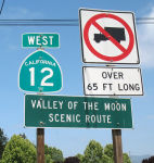 The portion of this route running through Sonoma County is called the "Valley of the Moon Scenic Route"
(~ SON 0.000 to SON 6.088). "Valley of the Moon" was the name Jack London,
resident of Glen Ellen, coined for this area.
The portion of this route running through Sonoma County is called the "Valley of the Moon Scenic Route"
(~ SON 0.000 to SON 6.088). "Valley of the Moon" was the name Jack London,
resident of Glen Ellen, coined for this area.
(Image Source: Flikr)
The portion of this route from Route 121 at Sears Point to Vallejo (~ SON 3.985 to SOL R9.565) is named the "Sears Point Toll Road". It was named by Chapter 393 in 1933.
The portion of Route 37 between the Atherton Avenue undercrossing at PM SON 13.773 and its junction with Route 121 at PM SON 3.900 is named the “Korean War Veterans Memorial Highway”. Named by Senate Resolution SCR 28, Resolution Chapter 64, 07/09/21.
 The portion of this route from Skaggs Island Road to Route 29 (~ SOL 1.688 to
SOL R9.703) is named the "Randy Bolt Memorial Highway". Special
Agent William Randall "Randy" Bolt was killed on May 9, 1995 in a traffic
accident while on duty as a special agent with the Department of Justice,
Bureau of Narcotic Enforcement. He was driving eastbound Route 37, east of
Skaggs Island Road, Solano County, California, when at approximately 7:25
a.m., a party driving a vehicle westbound crossed the painted double
yellow lines directly into the path of Randy Bolt's unmarked Department of
Justice vehicle. The two vehicles collided head-on and both Randy Bolt and
the party driving the other vehicle died instantly. He was only 48 years
old at the time of his death. Agent Bolt began his tenure as a law
enforcement officer for the State of California in the year 1968 with the
Fremont Police Department and subsequent to that employment, he was
employed by the Placer County Sheriff's Department and the San Rafael
Police Department. In 1988, he was appointed to the Department of Justice
and assigned to the Bureau of Narcotic Enforcement, Riverside regional
office. In 1990, he was transferred to the Bureau of Narcotic Enforcement,
San Francisco regional office where he worked until his untimely death.
Named by Assembly Concurrent Resolution 95, Chapter 128, September 24,
2001.
The portion of this route from Skaggs Island Road to Route 29 (~ SOL 1.688 to
SOL R9.703) is named the "Randy Bolt Memorial Highway". Special
Agent William Randall "Randy" Bolt was killed on May 9, 1995 in a traffic
accident while on duty as a special agent with the Department of Justice,
Bureau of Narcotic Enforcement. He was driving eastbound Route 37, east of
Skaggs Island Road, Solano County, California, when at approximately 7:25
a.m., a party driving a vehicle westbound crossed the painted double
yellow lines directly into the path of Randy Bolt's unmarked Department of
Justice vehicle. The two vehicles collided head-on and both Randy Bolt and
the party driving the other vehicle died instantly. He was only 48 years
old at the time of his death. Agent Bolt began his tenure as a law
enforcement officer for the State of California in the year 1968 with the
Fremont Police Department and subsequent to that employment, he was
employed by the Placer County Sheriff's Department and the San Rafael
Police Department. In 1988, he was appointed to the Department of Justice
and assigned to the Bureau of Narcotic Enforcement, Riverside regional
office. In 1990, he was transferred to the Bureau of Narcotic Enforcement,
San Francisco regional office where he worked until his untimely death.
Named by Assembly Concurrent Resolution 95, Chapter 128, September 24,
2001.
(Image sources: Officer Down Memorial Page; AAroads)
 The portion of this route between Route 29 and I-80 (~ SOL R9.703 to SOL R11.612) is named the Vallejo
Police Officer James Capoot Memorial Highway. It was named in
memory of James Lowell Capoot. He was born in 1966, in Little Rock,
Arkansas, attended local schools, and graduated from John L. McClellan
High School in 1985, where he excelled on the cross country and track
teams. After graduation, Jim enlisted in the United States Marine Corps,
and was stationed at the Mare Island Naval Shipyard in Vallejo. Jim
completed active duty with the United States Marine Corps in 1989, but
remained on active reserve until 1993, and he began his law enforcement
career with the Department of the California Highway Patrol in 1990. In
1993, Jim joined the Vallejo Police Department, where he served for over
18 years as a motorcycle officer, motorcycle instructor, driving
instructor, and SWAT officer. During his service with the Vallejo Police
Department, Jim received two Medals of Courage, one Life-Saving Medal, and
many other department commendations, as well as the Officer of the Year
Award. Jim was killed in the line of duty on November 17, 2011. Named by
Senate Concurrent Resolution 6, August 29, 2013. Resolution Chapter 85.
The portion of this route between Route 29 and I-80 (~ SOL R9.703 to SOL R11.612) is named the Vallejo
Police Officer James Capoot Memorial Highway. It was named in
memory of James Lowell Capoot. He was born in 1966, in Little Rock,
Arkansas, attended local schools, and graduated from John L. McClellan
High School in 1985, where he excelled on the cross country and track
teams. After graduation, Jim enlisted in the United States Marine Corps,
and was stationed at the Mare Island Naval Shipyard in Vallejo. Jim
completed active duty with the United States Marine Corps in 1989, but
remained on active reserve until 1993, and he began his law enforcement
career with the Department of the California Highway Patrol in 1990. In
1993, Jim joined the Vallejo Police Department, where he served for over
18 years as a motorcycle officer, motorcycle instructor, driving
instructor, and SWAT officer. During his service with the Vallejo Police
Department, Jim received two Medals of Courage, one Life-Saving Medal, and
many other department commendations, as well as the Officer of the Year
Award. Jim was killed in the line of duty on November 17, 2011. Named by
Senate Concurrent Resolution 6, August 29, 2013. Resolution Chapter 85.
(Image sources: Times-Herald, Vallejo Police Press Release)
 In Vallejo, Route 37 is "Marine
World Parkway" (~ SOL R9.738 to SOL R10.184). Marine World was
located in Vallejo; it is now Six Flags Discovery Kingdom, and it appears
the road was renamed to Lewis Brown Drive..
In Vallejo, Route 37 is "Marine
World Parkway" (~ SOL R9.738 to SOL R10.184). Marine World was
located in Vallejo; it is now Six Flags Discovery Kingdom, and it appears
the road was renamed to Lewis Brown Drive..
(Image source: ThemeParkBrochures)
 The eastbound I-80/Route 37 interchange (~
SOL R11.612) is named the "Gary L. Hughes Memorial Interchange".
Officer Gary L. Hughes and his partner Officer Lancer R. Thelen stopped
and arrested a suspected drunk driver along Interstate 80 in Vallejo.
Hughes was sitting in the rear of the patrol car with the suspect when a
pick-up truck camper plowed into the patrol car pinning Hughes against the
front seat and causing massive head injuries. The 38-year-old Patrol
officer died enroute to the hospital and the prisoner received minor
injuries. Thelen was near the front of the patrol car with a tow truck
operator completing paperwork for impounding the suspect's vehicle when
they were struck by the patrol car as it was rammed by the truck camper.
Thelen suffered a severe leg injury and the tow truck operator had a
compound leg fracture. The driver of the truck camper was taken into
custody on charges of felony drunk driving and manslaughter. Hughes was an
11-year veteran of the Patrol. Named by Assembly Concurrent Resolution
100, Chapter 124, in 1998.
The eastbound I-80/Route 37 interchange (~
SOL R11.612) is named the "Gary L. Hughes Memorial Interchange".
Officer Gary L. Hughes and his partner Officer Lancer R. Thelen stopped
and arrested a suspected drunk driver along Interstate 80 in Vallejo.
Hughes was sitting in the rear of the patrol car with the suspect when a
pick-up truck camper plowed into the patrol car pinning Hughes against the
front seat and causing massive head injuries. The 38-year-old Patrol
officer died enroute to the hospital and the prisoner received minor
injuries. Thelen was near the front of the patrol car with a tow truck
operator completing paperwork for impounding the suspect's vehicle when
they were struck by the patrol car as it was rammed by the truck camper.
Thelen suffered a severe leg injury and the tow truck operator had a
compound leg fracture. The driver of the truck camper was taken into
custody on charges of felony drunk driving and manslaughter. Hughes was an
11-year veteran of the Patrol. Named by Assembly Concurrent Resolution
100, Chapter 124, in 1998.
(Image source: California Association of Highway Patrolmen)
Historically, this route is close to the original "El Camino Real" (The Kings Road). A portion of this route has officially been designated as part of "El Camino Real by Assembly Bill 1707, Chapter 739, on October 11, 2001.
 Named Structures
 The Sonoma Creek Bridge (Bridge 23-0063, SON R000.01) is officially named the "Richard "Fresh Air"
Janson Bridge". It was named by Assembly Concurrent Resolution 68 in
1996. Richard Ludwig "Fresh Air Dick" Janson (d. 1951), a native of
Estonia who made his home in Sonoma County, is recognized as the premier
waterfowl decoy carver in the western United States. Known as "Fresh Air"
for his reverence for wildlife, Janson lived for most of his life on an
ark moored half a mile from the bridge—formerly known as the Sonoma
Creek Bridge; he died in 1951.
The Sonoma Creek Bridge (Bridge 23-0063, SON R000.01) is officially named the "Richard "Fresh Air"
Janson Bridge". It was named by Assembly Concurrent Resolution 68 in
1996. Richard Ludwig "Fresh Air Dick" Janson (d. 1951), a native of
Estonia who made his home in Sonoma County, is recognized as the premier
waterfowl decoy carver in the western United States. Known as "Fresh Air"
for his reverence for wildlife, Janson lived for most of his life on an
ark moored half a mile from the bridge—formerly known as the Sonoma
Creek Bridge; he died in 1951.
(Image sources: Press Democrat, Yelp)
 Interstate Submissions
Submitted for inclusion in the interstate system in 1945 and 1956; not accepted both times. Freeway currently exists from jct with US101 to approximately 4 miles east of US101 to Atherton Ave. Also another freeway section begins at 1 mile before Mare Island, over the Napa River Bridge, and ends 1/2 mile east of the bridge. Freeway then begins 1/2 mile east of Route 29 to junction with I-80.
Scenic Route Double Fine Zones
Between Route 121 and the intersection with Route 29. Authorized by Senate Bill 155, Chapter 169, on July 23, 1999.
 Classified Landcaped Freeway
The following segments are designated as Classified Landscaped Freeway:
| County | Route | Starting PM | Ending PM |
| Solano | 37 | R8.00 | R8.45 |
| Solano | 37 | 9.24 | 9.62 |
| Solano | 37 | 9.95 | 10.38 |
| Solano | 37 | 10.38 | R11.92 |
 Freeway
[SHC 253.1] Entire route. Added to the Freeway and Expressway system in 1959.
 Exit Information
 Other WWW Links
 Statistics
Overall statistics for Route 37:
 Interregional Route
[SHC 164.12] Between the east urban limits of San Francisco-Oakland near Novato and the west urban limits of San Francisco-Oakland near Vallejo.
 Pre-1964 Legislative Route
The route that was to become LRN 37 was originally defined in the 1909 statutes (not the bond act) via Chapter 224, which authorized the ...location, survey, and construction of a state highway from Emigrant Gap, Placer County in an E-ly direction through what is known as the Truckee Pass to the W end of Donner Lake in Nevada County... and it shall be the duty of the department to locate, survey, and construct said road along the line of the wagon road known as the Dutch Flat and Donner Lake wagon road..." Its route was changed in 1916 by Chapter 619 (later repealed) which was "for making a change in the location of the Emigrant Gap state road so as to eliminate the grade crossing of said road over the railroad track near Summit Station provided that the Southern Pacific company shall contribute not less than $3,500 for the same purpose." In 1915, Chapter 203 extended the route as part of "...the wagon road extending along the W side of Lake Tahoe, from McKinney's in El Dorado Cty to Tahoe City, thence along the Truckee River to Truckee, and thence in a W-ly direction to Donner Lake in Nevada Cty, connecting with the present state highway from Emigrant Gap" It was also extended by Chapter 678 that same year (1915), which called for "...the county road extending from Auburn in an E-ly direction and connecting with the Emigrant Gap state road at a point near Emigrant Gap." It was extended from Emigrant Gap to Verdi in the 1919 Third Bond Act.
By 1935, it had been codified into the highway code as:
"Auburn to Truckee via Emigrant Gap, the Truckee Pass, and the west end of Donner Lake"
This was primary state highway from Auburn to Truckee.
In 1957, Chapter 1911, relaxed the definition to be "Auburn to [LRN 38] via Emigrant Gap." Chapter 1698 would have changed this to "[LRN 17] near Auburn", but that was overridden by the 1963 renumbering.
© 1996-2020 Daniel P. Faigin.
Maintained by: Daniel P. Faigin
<webmaster@cahighways.org>.
 Route 36
 Route 38