
 California Highways:
Click here for a key to the symbols used. An explanation of acronyms may be found at the bottom of the page.
 Routing
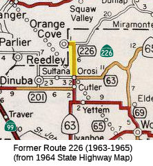 No current routing.
 Post 1964 Signage History
 In 1963, Route 226 was defined as the route "Route 63 near Orosi to
Orange Cove."
In 1965, Chapter 1372 deleted this route and transferred the routing to Route 63.
 Pre 1964 Signage History
This was LRN 132, defined in 1933.
LRN 132 was defined to run from north of Orosi to Orange Cove. LRN 132 north of Orosi followed Road 128 and Avenue 460 to Orange Cove in
1935, and was not signed in the 1934 original definition of State Sign
Routes. LRN 132 north of Orosi connected with Sand Creek Road, which was
once the primary highway to the logging town of Millwood.
(Source: Gribblenation Blog (Tom Fearer), "Former California State Route 226", 11/20/2023)
 Other WWW Links
 Pre-1964 Legislative Route
In 1947 (1st Ex Sess), Chapter 11 defined LRN 226 as the route “a point in the vicinity of the intersection of Webster Street and Santa Clara Avenue in Alameda to a point on [LRN 5] in Oakland”
In 1947, Chapter 1449 extended the definition of the route to include “the highway from San Leandro to Oakland via Alameda and the Posey Tube”. However this extension “is part of [LRN 252]”
In 1949, Chapter 1422 repealed the 1947 Chapter 1449 definition, and redefined Route 226 instead:
In 1955, Chapter 97 added "526.1 Upon the completion of the additional subterranean tube between the Cities of Oakland and Alameda, in the vicinity of Webster Street, to be used in connection with the Posey Tube, both of which tubes are included in the description of [LRN 226], the department may by executive order, rule, or regulation, designate both of said tubes, and the approaches leading to or from the nearest state highway or city street, as one-way highways, and thereafter restrict said tubes and approaches to one-way traffic, proceeding in opposite directions as to each other. Upon the placing of signs notifying the public of such restrictions, any person who wilfully fails to observe such sign is guilty of a misdemeanor."
In 1959, Chapter 1841 clarified the definition:
In 1961, Chapter 1146 relaxed the definition of (a): “[LRN 105] in San Leandro to [LRN 69] in Oakland near Seventh and
Harrison Streets via Alameda and the vicinity of Oakland
International AirportA point in the vicinity of the
intersection of Davis Street and East 14th Street in San Leandro, thence
via Davis Street through the City of San Leandro and through the City of
Oakland via Bayshore Boulevard and Doolittle Drive, thence through the
City of Alameda via Webster Street and Posey Tube and any other tube or
crossing to be used in conjunction with Posey Tube,”
Also in 1961, Chapter 2196 added “526.2 Because of the statewide interest in navigation, the state will hold and save the United States of America free and harmless from liability for damages to the parallel tubes between the Cities of Oakland and Alameda included in the description of [LRN 226] due to the initial dredging work and subsequent maintenance dredging in an area within 50 feet of said tubes in connection with the deepening of the Oakland Estuary by the Corps of Engineers of the United States Army and the Director of Finance shall execute an agreement so to do with the proper representatives of the United States of America.”
This route was signed as follows:
This is present-day Route 112 between Route 13 and Route 61; it is present-day Route 61 to unsigned Route 260 near Alameda, and unsigned Route 260 (signed as Route 61) to I-880 (through the Posey Tunnel).
This is approximately present-day I-980; it was originally part of the 1964-1984 routing of Route 24.
© 1996-2020 Daniel P. Faigin.
Maintained by: Daniel P. Faigin
<webmaster@cahighways.org>.
 Route 225
 Route 227