
 California Highways:
Click here for a key to the symbols used. An explanation of acronyms may be found at the bottom of the page.
 Routing
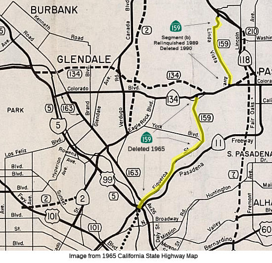 No current routing.
 Post 1964 Signage History
 ▸As defined in 1963, Route 159 consisted of two parts:
The "Great Renumbering" essentially renumbered the former Sign Route 11 as Route 159, capturing the former surface street routing (as the "Great Renumbering" renumbered the Arroyo Seco Parkway/Pasadena Freeway as Route 11).
▸In 1965, Chapter 1372 deleted (a) and added a condition: "This route shall cease to be a state highway when Route 210 freeway is completed from Route 134 to Linda Vista Avenue and the commission relinquishes that portion of present Route 210 from Route 134 to Linda Vista Avenue."
▸In 1992, part (2) was deleted per AB 3090, Chapter 1243. The route had been relinquished on 7/14/1989.
 Pre 1964 Signage History
Part (1) of the 1964 Route 159 was Figueroa Blvd between I-5 and Route 134, and was originally signed as Route 11 and US 66 (and later, as US 66A). Part 2 was Linda Vista Avenue between Route 134 and eventual I-210 (likely, it ended at Foothill Blvd before). This was signed as Route 11. Both segments were part of LRN 165, defined in 1933.
Note: For much of this history of this segment, see Route 11 and Route 110.
LRN 165 was routed from San Pedro to La Canada via Figueroa Street and
Linda Vista Avenue. The addition of LRN 165 made the three completed
Figueroa Street Tunnels part of the State Highway System and led to the
construction of the fourth southernmost tunnel. An opening ceremony
for the fourth Figueroa Street Tunnel was held on 8/4/1936. The
completion of the fourth Figueroa Street Tunnel connected US 99/US 66/Route 11/LRN 165 directly to US 101/LRN 2 at Sunset Boulevard.
(Source: Gribblenation Blog (Tom Fearer), "California State Route 159 (former California State Route 11 and US Route 66)", 1/2023)
In 1936, the Division of Highways announced plans for the North Figueroa
Street Viaduct and details the planned Arroyo Seco Parkway (LRN 205). The North Figueroa Street Viaduct would eliminate the jog in
US 99/US 66/Route 11/LRN 165 on Arroyo Seco Boulevard and Riverside Drive.
By 1938, Route 11 followed Linda Vista Avenue south from Sign Route 118 to
US 66 at Colorado Street. From Colorado Street, Route 11/US 66
followed Figuroa Street to the North Figuroa Street Viaduct. On
9/7/1940, the California State Highway Engineer submitted a request to
reroute US 66 onto the Arroyo Seco Parkway and redesignate the older route
on Figueroa Street co-signed with Route 11 as US 66A.
(Source: Gribblenation Blog (Tom Fearer), "California State Route 159 (former California State Route 11 and US Route 66)", 1/2023)
Just before the "Great Renumbering", US routes were truncated. US 66 was
approved to be truncated from Santa Monica to US 95 in Needles by the
AASHO on November 14, 1963. US 66A, which was concurrent with Route 11
between the Arroyo Seco Parkway and Pasadena, was approved to be deleted
by the AASHO Executive Committee on October 20, 1963.
(Source: Gribblenation Blog (Tom Fearer), "California State Route 159 (former California State Route 11 and US Route 66)", 1/2023)
One 1939 map shows Route 159 as being signed along the route along Lankershim Blvd between Route 134 (Alameda Avenue before the freeway) and US 99 (San Fernando Road). This appears to coincide with Lankershim's designation as LRN 159. Signed Route 159 was not defined in the 1934 initial set of state signed routes.
 Historical Route
Former part (1) of this route is signed as part of "Historic Highway Route 66", designated by Assembly Concurrent Resolution 6, Chapter 52, in 1991.
 National Trails
 The former part (1) of this route (Figueroa) was part of the "Arrowhead Trail (Ocean to Ocean Trail)". It was named by
Resolution Chapter 369 in 1925.
The former part (1) of this route (Figueroa) was part of the "Arrowhead Trail (Ocean to Ocean Trail)". It was named by
Resolution Chapter 369 in 1925.
 The former part (1) of this route (Figueroa) was part of the "National Old Trails Road".

 The former part (1) of this route (Figueroa) appears to have been part of the "National Park to Park Highway",
and the "Pikes Peak Ocean to Ocean Highway".
The former part (1) of this route (Figueroa) appears to have been part of the "National Park to Park Highway",
and the "Pikes Peak Ocean to Ocean Highway".
 Other WWW Links
 Pre-1964 Legislative Route
In 1933, the route from "Lankershim Blvd from [LRN 2] near Universal City to [LRN 4]" was defined as a state highway. In 1935, it was added to the highway code as LRN 159 with that routing.
In 1951, Chapter 1562 truncated and clarified the definition to be "[LRN 2] near Vineland Ave to [LRN 4] near Tujunga Wash"
In 1957, Chapter 1911 changed the origin to "[LRN 2] near Riverside Drive to …"
This route was Lankershim Blvd between US 101 and San Fernando Road. Some maps show it signed as Route 159, but that is clearly an error confusing the LRN with the signed rout number. The LRN was also applied to the present-day Route 170 freeway routing. Lankershim Boulevard was named for the town of Lankershim (first called Toluca, now North Hollywood) and its founding family. Isaac B. Lankershim grew wheat in a wide swath of the Valley.
© 1996-2020 Daniel P. Faigin.
Maintained by: Daniel P. Faigin
<webmaster@cahighways.org>.
 Route 158
 Route 160