
State Route 177
Click here for a key to the symbols used. An explanation of acronyms may be found at the bottom of the page.
 Routing
 From Route 10 near Desert Center to Route 62 near Granite Pass.
 Post 1964 Signage History
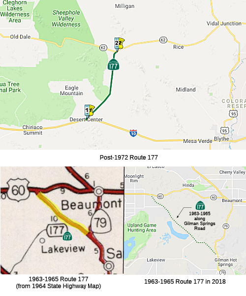
1963-1965: Gilman Springs Road
 In 1963, Route 177 was defined as “Route 79 near San Jacinto
to Route 60 near Moreno.” The routing was approximately along Gilman Springs Road. Lamb Canyon Road (now Route 79) was completed as a through
route in early '63; At that point, Route 79's alignment was shifted off
the north end of Gilman Springs Road and onto Lamb Canyon, and Route 177
was created for Gilman Springs Road.
In 1963, Route 177 was defined as “Route 79 near San Jacinto
to Route 60 near Moreno.” The routing was approximately along Gilman Springs Road. Lamb Canyon Road (now Route 79) was completed as a through
route in early '63; At that point, Route 79's alignment was shifted off
the north end of Gilman Springs Road and onto Lamb Canyon, and Route 177
was created for Gilman Springs Road.
In 1965, Chapter 1372 deleted this route.
Post-1972: Near Desert Center
In 1972, Chapter 1216 defined a new routing: “Route 10 near
Desert Center to Route 62 near Granite Pass.” It was built out over
the existing Rice Road.
 Pre 1964 Signage History
The 1964-1965 routing was part of Route 79, and was originally part of
LRN 194. In 1959, the legislative route number was changed to LRN 186. It
was signed by 1963, but was not part of the 1934 definition of Route 79.
The post-1972 routing was not defined in 1963.
There was no signed Route 177 as part of the initial state signage of
routes in 1934. It is unclear what (if any) route was signed as Route 177
between 1934 and 1964.
 Other WWW Links
 Statistics
Overall statistics for Route 177:
- Total Length (1995): 27 miles
- Average Daily Traffic (1992): 1,050 to 4,100
- Mileage Classification: Rural: 27; Sm. Urban: 0; Urbanized: 0.
- Previous Federal Aid Mileage: FAP: 27 mi.
- Functional Classification: Minor Arterial: 27 mi.
- Counties Traversed: Riverside.
 Pre-1964 Legislative Route
In 1933, Chapter 767 added the route from “Brea to [LRN 77] near
Chino” to the highway system. In 1935, this was added to the highway
code with the routing:
“[LRN 176] near Brea to [LRN 77] near Chino”
This routing remained unchanged until the 1963 "great renumbering. This
route ran from Route 90 (nee Route 42) near Brea to Route 71 near Chino.
It is part of present-day Route 142. It originally split off or Route 90
[LRN 176] at Carolina (now Kraemer), then Birch/Brea/Olinda Blvd to
Valencia Ave, and then up to Carbon Canyon Rd. Sometime after 1959, it was
rerouted to take Valencia Ave from Imperial Highway.
Acronyms and Explanations:
- "LRN" refers to the Pre-1964 Legislative Route Number.
"US" refers to a US Shield signed route.
"I" refers to an Eisenhower Interstate signed route.
"Route" usually indicates a state shield signed route, but said route may be signed as US or I.
- Previous Federal Aid (pre-1992) categories:
Federal Aid Interstate (FAI); Federal Aid Primary (FAP);
Federal Aid Urban (FAU); and Federal Aid Secondary (FAS).
Current Functional Classifications (used for aid purposes):
Principal Arterial (PA); Minor Arterial (MA);
Collector (Col); Rural Minor Collector/Local Road (RMC/LR). Note that ISTEA repealed the previous Federal-Aid System, effective in 1992, and established the functional classification system for all public roads.
- Other frequently used terms: California Transportation Commission (Commission or CTC), California Department of Transportation (Department or Caltrans), Regional Improvement Program (RIP), Interregional Improvement Program (IIP), State Transportation Improvement Program (STIP), State Highway Operation and Protection Program (SHOPP), Traffic Congestion Relief Program (TCRP), Clean Air and Transportation Improvement Act of 1990 (Proposition 116), High Speed Passenger Train Bond Program (Proposition 1A), Highway Safety, Traffic Reduction, Air Quality, and Port Security Bond Act of 2006 (Proposition 1B), Corridor Mobility Improvement Account (CMIA), State Route 99 Bond Program (RTE or SR 99), Local Bridge Seismic Retrofit Account (LBSRA), Trade Corridors Improvement Fund (TCIF), Highway-Railroad Crossing Safety Account (HRCSA), State-Local Partnership Program (SLPP), Environmental Phase (PA&ED), Design Phase (PS&E), Right of Way (R/W), Fiscal Year (FY), Active Transportation Program (ATP), Trade Corridor Enhancement Program (TCEP), Local Partnership Program (LPP), Local Streets and Roads Program (LSRP), Solutions for Congested Corridors Program (SCCP).
 Route 176
 Route 178
© 1996-2020 Daniel P. Faigin.
Maintained by: Daniel P. Faigin
<webmaster@cahighways.org>.

 California Highways: