
 California Highways:
Click here for a key to the symbols used. An explanation of acronyms may be found at the bottom of the page.
 Routing
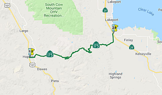 From Route 101 at Hopland to Route 29 near Lakeport.
 Post 1964 Signage History
As defined in 1963, this segment was "(a) Route 101 to Route 29 near Lakeport."
In 1994, Chapter 1220 clarified the routing of this segment: "(a) Route 101 at Hopland to Route 29 near Lakeport."
 Pre 1964 Signage History
This segment (19 mi) was LRN 16, defined in 1909, and appears not to have been signed before 1964.
LRN 16 between Hopland and Lakeport was shown as completed on the 1920
Clason Highway Map of California.
(Source: Gribblenation Blog, "California State Route 175", September 2020)
 Status
In July 2009, the CTC approved relinquishment of right of way in the county of Mendocino along Route 175 in Old Hopland at East Side Road (~ MEN 1.136), consisting of a reconstructed and relocated county road.
In March 2011, the CTC approved funding a number of projects on this route. Near Hopland from the Junction of Route 101 to 0.6 mile east of Mendocino/Lake County Line (~ MEN 0.064 to LAK 0.600), Route 175 will have 21.0 lane miles of roadway rehabilitated by overlaying with asphalt concrete to improve the ride quality, prevent further deterioration of the traveling surface, minimize costly roadway repairs, and extend the pavement service life. In Lake County, near Lakeport, from 4.9 miles east of Mendocino/Lake County Line to Route 175/Route 29 Junction; also near Kelseyville from Route 175/Route 29 Junction to Route 175/Route 29 Junction in Middletown there will be a project to rehabilitate 46.2 lane miles of roadway by overlaying with asphalt concrete to improve the ride quality, prevent further deterioration of the traveling surface, minimize costly roadway repairs, and extend the pavement service life.
Curve Realignment near McDowell Creek/Oasis (01-Lak-175 0.2/0.4)
") In October 2018, the CTC amended the following into the
2018 SHOPP: 01-Lak-175 0.2/0.4. PPNO 3118. Project 0117000226. EA 0H460.
Route 175 Near Hopland, from 0.2 mile east to 0.4 mile east of Mendocino
County line. Curve realignment and shoulder widening. Est. cost:
$5,770,000. Est. const. begin: 12/22/2021. The CTC also approved the
following allocation: $510,000. 01-Lak-175 0.2/0.4. Route 175 Near
Hopland, from 0.2 mile east to 0.4 mile east of Mendocino County line.
Curve realignment and shoulder widening. PPNO 3118. Project 0117000226. EA
0H460.
In October 2018, the CTC amended the following into the
2018 SHOPP: 01-Lak-175 0.2/0.4. PPNO 3118. Project 0117000226. EA 0H460.
Route 175 Near Hopland, from 0.2 mile east to 0.4 mile east of Mendocino
County line. Curve realignment and shoulder widening. Est. cost:
$5,770,000. Est. const. begin: 12/22/2021. The CTC also approved the
following allocation: $510,000. 01-Lak-175 0.2/0.4. Route 175 Near
Hopland, from 0.2 mile east to 0.4 mile east of Mendocino County line.
Curve realignment and shoulder widening. PPNO 3118. Project 0117000226. EA
0H460.
(Source: October 2018 CTC Agenda Item 2.1a.(1) Item
15; Agenda Item 2,.,5b.(2a) Item 1)
In January 2020, the CTC approved the following
pre-construction allocation: 01-Lak-175 0.2/0.4. PPNO 3118. ProjID
0117000226. EA 0H460. Route 175 near Hopland, from 0.2 mile east to 0.4
mile east of Mendocino County line. Curve realignment and shoulder
widening. Allocation: PS&E $1,256,000; R/W Sup $143,000
(Source: January 2020 CTC Agenda, Agenda Item
2.5b.(2a) #2)
The 2020 SHOPP, approved in May 2020, included the
following Collision Reduction item of interest (carried over from the 2018
SHOPP): 01-Lake-175 PM 0.2/0.4 PPNO 3118 Proj ID 0117000226 EA 0H460.
Route 175 near Hopland, from 0.2 mile east to 0.4 mile east of Mendocino
County line. Curve realignment and shoulder widening. Programmed in
FY21-22, with construction scheduled to start in December 2021. Total
project cost is $5,770K, with $2,886K being capital (const and right of
way) and $2,884K being support (engineering, environmental, etc.),
(Source: 2020 Approved SHOPP a/o May 2020)
In December 2020, the CTC amended the 2020 SHOPP to
revise the following project as indicated: 01-Lak-175 PM 0.2/0.4 PPNO
01-3118 ProjID 0117000226 EA 0H460. Route 175 Near Hopland, from 0.2 mile
east to 0.4 mile east of Mendocino County line. Curve realignment and
shoulder widening. Changes: R/W Cap $7K $136K; and
Const Cap $2,879K $2,750K. The total remains the
same. Explanation: To minimize the risk of delays to this safety project,
the removal of trees and shrubs will be done during non-bird- nesting
period prior to construction under a separate contract, thus increasing
R/W capital and decreasing construction capital.
(Source: December 2020 CTC Agenda, Agenda Item
2.1a.(1d) #1)
In January 2021, the CTC was informed of the following
SHOPP Safety allocation under delegated authority: (3) #1. $3,366,000.
01-Lak-175 0.2/0.4. PPNO 01-3118 ProjID 0117000226 EA 0H460. Route 175
Near Hopland, from 0.2 mile east to 0.4 mile east of Mendocino County
line. Outcome/Output: Improve safety by realigning curves and
and widening shoulders. This project will reduce the number and severity
of collisions. CON ENG $975,000; CONST $2,750,000.
(Source: March 2021 CTC Agenda, Agenda Item
2.5f.(3) #1)
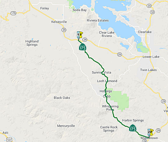 From Route 29 near Kelseyville to Route 29 at Middletown.
Post 1964 Signage HistoryIn 1963, this segment was defined as “(b) Route 29 to Route 29 near Middletown.” This reflected Route 29 being assigned to a new routing onto what had been LRN 243 and Route 53/LRN 49 between Lower Lake south to Middletown, and the old routing becoming Route 175.
In 1992, Chapter 1243 clarified the definition of (b): “(b) Route 29 near Kelseyville to Route 29 near Middletown.”
In 1994, Chapter 1220 further clarified the routing of this segment:
“(b) Route 29 near Kelseyville to Route 29 near at
Middletown.”
Note: Between Lakeport and Kelseyville, the route is multiplexed with Route 29.
Pre 1964 Signage HistoryThis segment was originally signed as part of the original 1934 definition of Route 29. It was LRN 89, defined in 1933. Route 29 presently takes a direct route over LRN 243, defined in 1959 between Lower Lake and Kelseyville.
StatusIn March 2017, the CTC amended the SHOPP to include $2,450,000 in funding on Route 175 near Middletown, from 0.2 mile east of Grouse Springs Road to 0.1 mile east of Socrates Mine Road (1-Lak-175 17.4/23.6, between Adams and Hoberg). Remove slide debris, repair drainage systems, reconstruct roadway, and conduct further geotechnical investigations of slope and roadway settlement. This was the result of damage from the Winter 2017 storms.
Kelsey Creek Bridge No. 14-0044 (LAK 19.48)
In June 2019, the CTC also approved the following SHOPP
scope amendment: 01-Lak-29 50.8 PPNO 3130 ProjID 0118000172. Route 29 Near
Upper Lake, at Robinson Creek Bridge No. 14 -0030 (PM 50.82); also on
Route 175 at Kelsey Creek Bridge No. 14-0044 (PM 19.48); also on
Route 20 at Morrison Creek Bridge No. 14-0004 (PM 16.81). Widen
bridge and upgrade bridge rails at Robinson Creek Bridge and
Morrison Creek Bridge, and replace existing Kelsey Creek Bridge.
Remove Morrison Creek Bridge from project EA 0E080/PPNO 01-3098 and add to
this project. The need for cultural analysis delayed the Morrison Creek
Bridge delivery schedule and it now better aligns with this project.
Further cost increases are associated with additional piles, retaining
wall, and required environmental mitigation. Updated total cost: $10,833K.
(Source: June 2019 CTC Minutes, Agenda Item
2.1a.(1) Scope Item 11)
In August 2020, the CTC approved for future
consideration of funding a project is located on Route 20 (01-Lak-20, PM
16.81), Route 29 (01-Lak-29, PM 50.82), and Route 175 (01-Lak-175, PM
19.48) at various locations in Lake County. The Department proposes to
widen and upgrade bridge rails at Robinson Creek Bridge and Morrison
Creek Bridge, and replace existing Kelsey Creek Bridge. This project is
fully funded and is currently programmed in the 2020 State Highway
Operation Protection Program (SHOPP) for a total of $14,076,000 which
includes Construction (capital and support) and Right of Way (capital and
support). Construction is estimated to begin in Fiscal Year 2021-2022. The
scope, as described for the preferred alternative, is consistent with the
project scope programmed by the Commission in the 2020 SHOPP.
(Source: August 2020 CTC Agenda, Agenda Item
2.2c.(1))
Related to the previous item, also in August 2020 the
CTC approved the following financial allocation: $2,220,000 for PS&E;
$223,000 for R/W Support. 01-Lak-29 PM 50.8. PPNO 3130 ProjID 0118000172
EA 0E081. Route 29 Near Upper Lake, at Robinson Creek Bridge No. 14-0030
(PM 50.82); also on Route 175 at Kelsey Creek Bridge No. 14-0044 (PM
19.48); also on Route 20 at Morrison Creek Bridge No. 14-0004 (PM 16.81).
Widen bridge and upgrade bridge rails at Robinson Creek Bridge and
Morrison Creek Bridge, and replace existing Kelsey Creek Bridge.
(Source: August 2020 CTC Agenda, Agenda Item
2.5b.(2b) #1)
Lake 175-Middletown Shoulders
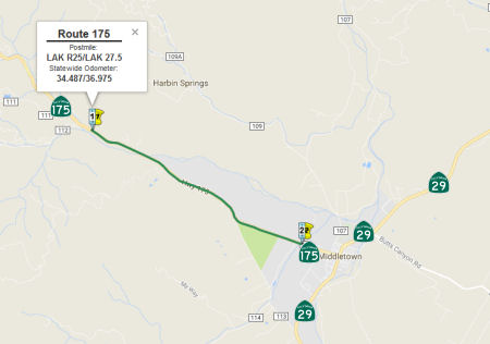 In August 2017, the CTC approved for future consideration of funding 01-Lak-175, PM R25/27.5 Lak
175-Middletown Shoulders: a safety improvement project in Lake County that
will widen roadway shoulders on Route 175 near the town of Middletown. The
project will be funded from State Highway Operation and Protection Program
(SHOPP) funds and is programmed in the 2016 SHOPP for an estimated $21.1
million Construction (capital and support) and Right of Way (capital and
support). Construction is tentatively scheduled to begin in Fiscal Year
2018-19. The scope, as described for the preferred alternative, is
consistent with the project scope programmed by the Commission in the 2016
SHOPP. A copy of the MND has been provided to Commission staff. The
project will result in less than significant impacts to the environment
after mitigation. The following resource areas may be impacted by the
project: aesthetics, agriculture, biological resources, public services,
recreation, and cultural resources. Avoidance and minimization measures
will reduce any potential effects on the environment. These measures
include, but are not limited to, access to agricultural parcels shall be
maintained during construct, all disturbed areas shall be revegetated and
restored, assumed cultural sites will be protected by the implementation
of an Environmentally Sensitive Area Action Plan, and pre-construction
roosting bat surveys shall be performed by a qualified biologist. As a
result, an MND was completed for this project.
In August 2017, the CTC approved for future consideration of funding 01-Lak-175, PM R25/27.5 Lak
175-Middletown Shoulders: a safety improvement project in Lake County that
will widen roadway shoulders on Route 175 near the town of Middletown. The
project will be funded from State Highway Operation and Protection Program
(SHOPP) funds and is programmed in the 2016 SHOPP for an estimated $21.1
million Construction (capital and support) and Right of Way (capital and
support). Construction is tentatively scheduled to begin in Fiscal Year
2018-19. The scope, as described for the preferred alternative, is
consistent with the project scope programmed by the Commission in the 2016
SHOPP. A copy of the MND has been provided to Commission staff. The
project will result in less than significant impacts to the environment
after mitigation. The following resource areas may be impacted by the
project: aesthetics, agriculture, biological resources, public services,
recreation, and cultural resources. Avoidance and minimization measures
will reduce any potential effects on the environment. These measures
include, but are not limited to, access to agricultural parcels shall be
maintained during construct, all disturbed areas shall be revegetated and
restored, assumed cultural sites will be protected by the implementation
of an Environmentally Sensitive Area Action Plan, and pre-construction
roosting bat surveys shall be performed by a qualified biologist. As a
result, an MND was completed for this project.
In August 2018, the CTC approved $14,044,000 in
SHOPP Safety Resolution G-03-10 Delegated Allocations for Lake 01-Lak-175
R25.0/27.5: Route 175 Near Middletown, from 0.1 mile east of Putah Creek
Bridge to Dry Creek Bridge. Outcome/Output: Improve safety by widening
shoulders, installing rumble strips, improving roadside clear recovery
zone, and extending existing culverts. This project will reduce the number
and severity of collisions.
(Source: August 2018 CTC Agenda Item 2.5f.(3) Item
2)
Pre 1964 Signage HistorySigned Route 175 was not defined as part of the initial state signage of routes in 1934. It is unclear what (if any) route was signed as Route 175 between 1934 and 1964.
 Other WWW Links
 Statistics
Overall statistics for Route 175:
 Pre-1964 Legislative Route
In 1933, Chapter 767 defined the route "[LRN 60] near Hermosa Beach to [LRN 43] in Santa Ana Canyon via Artesia Ave" as part of the state highway system. In 1935, this route was added to the highway code as LRN 175 with that definition.
In 1957, Chapter 36 relaxed the routing: "[LRN 60] near Hermosa Beach to
[LRN 43] in Santa Ana Canyon via Artesia Ave"
This route ran from Route 1 near Hermosa Beach to Route 18/US 91 in Santa Ana Canyon, generally along Artesia and Orangethorpe, turning at Imperial Highway. It later became the Riverside Freeway. This is former Route 14, also known as US 91; it is present-day Route 91.
© 1996-2020 Daniel P. Faigin.
Maintained by: Daniel P. Faigin
<webmaster@cahighways.org>.
 Route 174
 Route 176