
 California Highways:
Click here for a key to the symbols used. An explanation of acronyms may be found at the bottom of the page.
 Routing
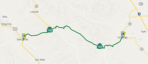 From Route 101 near San Lucas to Route 33 at Coalinga.
 Post 1964 Signage History
This segment remains as defined in 1963.
In 1965, the California Highway Commission adopted a freeway location for 1.1 miles of Route 198 near San Lucas to provide a connection with the future US 101 Freeway. The new routing leaves the existing highway northeast of Cemetery Road, proceeds southwesterly to southwest of existing US 101, then turns more westerly to future US 101.
The portion of Route 198 between US 101 and San Lucas was the original routing of US 101. The bypass of King City, San Lucas, and San Ardo was adopted in 1962.
 Pre 1964 Signage History
This route was all LRN 10. The portion between Hanford and Route 99 was defined in 1909. The portion from US 101 to Hanford was defined in 1915, and the remainder (Route 99 to Sequoia National Park) was defined in 1919. In 1934, Route 198 was signed from Jct. US 101 at San Lucas to Sequoia National Park via Coalinga.
San Lucas (~ MON R0.55)
The original alignment of US 101 was carried on LRN 2
(created in 1909). Surveyed in 1910, by 1917 the route was routed on Main
Street in San Lucas. Future Route 198 originally followed Mary Street via
LRN 10 (extended to San Lucas in 1915) into San Lucas and Main Street. By
1925, LRN 2 had been rerouted and shifted west of the Southern Pacific
Railroad in San Lucas onto what is now Cattlemen Road. This led to LRN 10
being extended through San Lucas via Main Street to a new terminus at
Lockwood-San Lucas Road and Cattleman Road. This aligned LRN 10 directly
with the 1915 Salinas River Bridge located on Lockwood-San Lucas Road. In
1926, LRN 2 was signed as US 101; in 1934, LRN 10 was signed as Route 198.
(Source: Gribblenation Blog (Tom Fearer), "Former US Route 101 and California State Route 198 in San Lucas", November 2022)
Beginning in 1965, work began to realign US 101 to a
freeway grade between San Ardo north to King City. This also included a
1.1-mile realignment of Route 198 to the US 101 freeway in San Lucas.
Right of way acquisition for both US 101 and Route 198 realignments began
at that time. is stated to be planned to commence during 1965. In 1972, US 101 was shifted to a new freeway west of Cattlemen Road and Route 198 was
extended directly to it via an interchange structure south of San Lucas.
Former Route 198 in San Lucas was partially severed after the highway was
realigned, as Mary Street no longer directly connects traffic from Route 198 to Main Street. The Southern Pacific Railroad crossing from Main
Street to Cattlemen Road/Lockwood-San Lucas Road was removed.
(Source: Gribblenation Blog (Tom Fearer), "Former US Route 101 and California State Route 198 in San Lucas", November 2022)
The 1918 State Highway Map shows LRN 10 completed between Goshen west to
Hanford but only a proposed highway west to San Lucas. As LRN 10 west of
Hanford was unconstructed; the implied route of the highway west to San
Lucas had to traverse the marsh lands of Tulare Lake. The 1917 California
State Automobile Association map indicates that implied route west of
Lemoore to Coalinga was as follows:
(Source: Gribblenation Blog "California State Route 198", snapshotted 11/11/2019)
The 1920 State Highway Map shows the planned alignment of LRN 10 between
Lemoore and Coalinga as only partially constructed. The route of LRN 10
west from Lemoore was planned to be aligned completely west of Lemoore on
Jackson Avenue into the Diablo Range where it would have turned south from
the Oilfields to Coalinga.
(Source: Gribblenation Blog "California State Route 198", snapshotted 11/11/2019)
 Naming
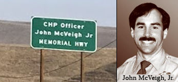 The portion of Route 198
from the junction with Route 101 (~ MON R0.209) to the County of Fresno (~
MON 25.726/FRE 0.0) is officially designated the "John McVeigh, Jr.
Memorial Highway". Officer John N. McVeigh, Jr. was responding to an
injury accident on Route 198 in the area of King City, in the County of
Monterey on April 17, 1993 when he lost control of his patrol car as it
rounded a curve. McVeigh’s patrol car spun into the opposing lane of
traffic where it was struck broadside by an oncoming pick-up. Although
McVeigh was securely belted in his seat and his air bag deployed, the
force of the impact killed the 38-year-old officer instantly. Officer
McVeigh was a 13-year veteran of the CHP and a 1992 King City Officer of
the Year. During that year he made more than 2,500 enforcement contacts,
most of which were for violations identified as primary reasons why
collisions occur. Officer McVeigh was raised in Daly City, attended St.
Ignatius High School in San Francisco and graduated from Santa Clara
University where he studied accounting. cVeigh began his career with the
CHP in 1980 after graduating from the CHP academy in Sacramento. He served
in Westminster, Redwood City, and Monterey before joining the King City
office at the end of 1991. Named by Assembly Concurrent Resolution No.
119, Chapter 147, in 1994.
The portion of Route 198
from the junction with Route 101 (~ MON R0.209) to the County of Fresno (~
MON 25.726/FRE 0.0) is officially designated the "John McVeigh, Jr.
Memorial Highway". Officer John N. McVeigh, Jr. was responding to an
injury accident on Route 198 in the area of King City, in the County of
Monterey on April 17, 1993 when he lost control of his patrol car as it
rounded a curve. McVeigh’s patrol car spun into the opposing lane of
traffic where it was struck broadside by an oncoming pick-up. Although
McVeigh was securely belted in his seat and his air bag deployed, the
force of the impact killed the 38-year-old officer instantly. Officer
McVeigh was a 13-year veteran of the CHP and a 1992 King City Officer of
the Year. During that year he made more than 2,500 enforcement contacts,
most of which were for violations identified as primary reasons why
collisions occur. Officer McVeigh was raised in Daly City, attended St.
Ignatius High School in San Francisco and graduated from Santa Clara
University where he studied accounting. cVeigh began his career with the
CHP in 1980 after graduating from the CHP academy in Sacramento. He served
in Westminster, Redwood City, and Monterey before joining the King City
office at the end of 1991. Named by Assembly Concurrent Resolution No.
119, Chapter 147, in 1994.
(Image source: Gribblenation; California Assn of Highway Patrolmen)
 Scenic Route
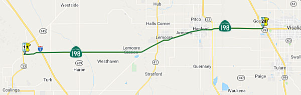 From Route 33 near Oilfields to Route 99 via Hanford.
Post 1964 Signage HistoryThis segment remains as defined in 1963.
Pre 1964 Signage HistoryThis route was all LRN 10. The portion between Hanford and Route 99 was defined in 1909. The portion from US 101 to Hanford was defined in 1915, and the remainder (Route 99 to Sequoia National Park) was defined in 1919. In 1934, Route 198 was signed from Jct. US 101 at San Lucas to Sequoia National Park via Coalinga.
Tom Fearer investigated the original routing of Route 198 in Kings
County. He noted:
(Source: Tom Fearer (Max Rockatansky) on AARoads, March 2017)
The original 1934 alignment westbound followed the modern expressway from the Tulare County line to approximately 7th Avenue. Route 198 used East Lacey Blvd to reach Hanford, 7th Street west, Irwin Street north to downtown, and west on West Lacey Blvd to exit the city. West of Hanford, Route 198 used West Lacey Blvd and south on 14th Avenue to reach Armona. From downtown Armona, Route 198 took Front Street west to Hanford-Armona Road to exit the city. Route 198 continued west on Hanford-Armona bypassing Lemoore to the north to reach Route 41 on 19½th Avenue. Route 198 multiplexed Route 41 south on 19½th Avenue to Jackson Avenue where it split west over the Kings River to roughly where the old alignment dead ends at the modern Route 198 expressway. It would appear the above alignment largely stayed the same with the expection of a minor realignment in Hanford on 7th Street to Garner Avenue to reach West Lacey Blvd. It appears that the Route 198 expressway was partially completed west of Lemoore by 1964, with additional segments opened between Lemoore to 10th Avenue in Hanford in 1966, and the full modern alignment by 1967. The modern alignment was gradually improved over the years to almost a full freeway between 7th Avenue and 25th Avenue."
The original alignment of Route 198 wasn't so much in the way substantially different than the modern route when it was plotted out in 1934, but lacked the modern easement of the modern bypass curves. Most of the Route 198 freeway from Route 99 roughly follows the initial alignment of Route 198 to Visalia. The initial 1934 route of Route 198 in the City of Visalia ran on Main Street east/west into downtown before cutting south on Court Street. Route 198 was routed south via Court Street to Mineral King Avenue where it resume heading in an east/west direction. East out of Visalia to modern Route 65 and Route 245 much of the route of Route 198 freeway/expressway still occupies the general alignment of the original Route 198 design.
In 1937 there may have been a change of Route 198 to take Coyner Street from Main to reach Mineral King Avenue. A 1940 document seems to suggest that Route 198 continued east from Court to Bridge Street from which it reached Mineral King Avenue. At some point in time prior the freeway construction through Visalia it is likely that westbound Route 198 was shifted onto Center Avenue and eastbound continued one-way on Main Street like the modern traffic configuration does today, but I can't prove it. Likewise Route 198 may at some point been one-way south on Locust Avenue to Mineral King Avenue and one-way northbound much like the modern alignment of Route 63 through downtown Visalia. The freeway alignment of Route 198 was approved in 1961 and was gradually built over the next couple years with completion in 1965. There was some variations with sections between Route 99 and Visalia being an expressway as opposed to the freeway it is today,
East of Route 65 and Route 245 (originally Route 65) the alignment to the Terminus Dam is very much in the same general area but very different than the 1934 alignment. Route 198 turned north off the modern Route 198 alignment in Yokohl on Road 220 north, Avenue 312 east, Road 228 north, 7th Avenue/Moffet Drive/Road 236 northeast, and Avenue 324 back to the modern alignment in Lemon Cove. Route 198 appears to have zig-zagged through Lemon Cove on Road 244, Pogue Avenue, modern CA 198, Lemon Road, Avenue 330, and modern Route 198 to make it through the town.
North of Lemon Cove, Route 198 would have passed modern Route 216, likely using Road 248 north, Avenue 338 east, Road 249 north, and Avenue 340 east to reach the site of the modern Terminus Dam. The alignment I just described is not on the 1935 Tulare County Map but there is a very obvious concrete road bed leading up to the Terminus Dam, The 1938 State Highway Map appears to have it however. At some point Route 198 may have used Long Drive. Route 198 was realigned to the south from 1961 to 1962 due to the construction of the Terminus Dam and opening of the Lake Kaweah Reservoir.
Tom Fearer also noted: During the 1919 Third State Highway Bond Act, LRN 10 was extended east from Visalia to the Colony Mill Road of Sequoia
National Park. The original route of LRN 10 in Tulare County split from
LRN 4 at Main Street and Mooney Boulevard in Visalia. It appears that LRN 10 east of downtown Visalia traversed southeast to Visalia Road through
Farmersville and Exeter before swinging back north on Kaweah Avenue
(current CA 65) to the current surface alignment of CA 198 east of CA 245.
This early alignment of LRN 10 can be seen on the 1920 State Highway Map.
The southeast jog of LRN 10 from downtown Visalia to Visalia Road doesn't
align to any current existing roadways and likely was on rail frontage
facilities. as East of current Route 245 the alignment of LRN 10 to the
site of the Terminus Dam was very different than modern Route 198. LRN 10
turned north off the modern Route 198 alignment in Yokohl on Road 220
north, Avenue 312 east, Road 228 north, 7th Avenue/Moffet
Drive/Road 236 northeast, and Avenue 324 back to the modern alignment in
Lemon Cove. LRN 10 appears to have zig-zagged through Lemon Cove on Road
244, Pogue Avenue, modern Route 198, Lemon Road, Avenue 330, and modern
Route 198 to make it through the town. East of Lemon Cove LRN 10 would
have passed modern CA 216 and used Road 248 north, Avenue 338 east, Road
249 north, and Avenue 340 east to reach the site of the modern Terminus
Dam. At some point LRN 10 was moved onto what is now Long Drive (which was
probably when the 1922 Pumpkin Hollow Bridge was built) approaching the
Terminus Dam site.
(Source: Gribblenation Blog "California State Route 198", snapshotted 11/11/2019)
Tom's blog post on Gribblenation Blog "California State Route 198" has loads of details on how the routing changed over time.
 Status
In March 2016. it was reported that Kings County had a 20-year wish list
totaling approximately $1.2 billion to transition a number of highways to
four lanes: Route 43 from Selma to Corcoran; Route 41 from Lemoore to
Kettleman City and Route 198 from I-5 (~ FRE 26.908) to Naval Air Station
Lemoore (~ KIN 2.678). However, Kings County is only expected to get $3.5
million from the State Transportation Improvement Plan (STIP) designed for
capacity increasing projects in the 2013-2014 period.
(Source: Andy3175 @ AAroad, March 2016; HartfordSentinal,
9/7/2013).
In July 2005, the CTC considered vacation of right of way in the County of Kings, at Avenue 25, consisting of highway right of way easement no longer needed for State highway purposes (6-Kin-198-PM 3.03).
In September 2005, the CTC considered a project for Route 198 in Kings County to convert at-grade intersection to partial interchange and upgrade from urban expressway to freeway between Route 41 (~ KIN 8.761) and Vine St. in Lemoore (~ KIN R10.035).
In January 2019, the CTC authorized relinquishment of right of way in the
city of Lemoore (City) along Route 198 on 19th Avenue and Iona
Avenue (06-Kin-198-PM R9.47), consisting of local street improvements. The
City by relinquishment agreement dated October 18, 2018, agreed to waive
the 90-day notice requirement and accept title upon relinquishment by the
State.
(Source: January 2019 CTC Minutes, Agenda Item 2.3c)
In December 2022, the CTC authorized relinquishment of right of way,
consisting of collateral facilities, in the city of Lemoore along Route 198 on Vine Street (06-Kin-198-PM 10.04, 2 segments), under the terms and
conditions as stated in the freeway agreement dated February 7, 1984. The
City acknowledged they received the 90-day notice on August 15, 2022, and
the 90-day notice period expired on November 13, 2022.
(Source: December 2022 CTC Agenda, Agenda Item
2.3c)
Route 41 to Route 99 through Hanford
Route 198/Route 216 Junction Widening (06-Tul-216 1.967/06-Tul-198 R11.736)
In September 2020, it was reported that CalTrans plans
to improve the interchange between Route 216 and Route 198. In May 2016,
Visalia and CalTrans staff held a joint public hearing to discuss
improvements to the interchange. In order to solve congestion at the
Lovers Lane interchange of Route 198, the city and (CalTrans) are
proposing improvements and changes at the intersections of Lovers Lane and
Noble Avenue, Lovers Lane and Route 198 eastbound ramp, Mineral King Ave
and Route 198 westbound ramp and Lovers Lane and Mineral King. Originally
proposed with a $60 million price tag in 2016 to close a portion of
Mineral King Ave affecting both homes and businesses, the current project
relies on a future planned highway interchange at Tower Road (Road 148),
less than a mile east of Lovers Lane to relieve congestion at the Lovers
Lane interchange. The new project is estimated to cost $21.5 million. The
California Transportation Commission approved for the design and
environmental phase of the project to be funded through the State Highway
Operation and Protection Program (SHOPP) fund. It is anticipated the
design and right-of-way for the project could be completed by early 2023,
with bidding and construction complete by the middle of 2025. The proposed
improvements include:
(Source: Sun Gazette, 9/16/2020)
In February 2022, it was reported that Lovers Lane
interchange improvements are on track to begin in fall 2023, with widening
of Lovers Lane slated to start in spring 2023. In May 2021, CalTrans
selected a plan to improve the interchange following several presentations
to the council and the Visalia community. Under the proposed plan, both
Buck Road and Mineral King Boulevard would dead-end at the interchange.
Westbound traffic exiting Route 198 would not stop until Lovers Lane,
which would be widened to four lanes of through traffic with left and
right turn lanes, and both the on and off ramps would be widened to two
lanes. At the May 2021 meeting, the city council was concerned residents
living north of the highway and east of Lovers Lane would be losing all
access to Lovers Lane unless they accessed Route 216 via McAuliff and Mill
Creek Parkway. In order to ease local residents into the realigned
interchange, a hybrid plan was developed allowing westbound Mineral King
Avenue to curve north of the current interchange and connect with Lovers
Lane at Duran Avenue, but Duran itself would end in a cul-de-sac just
before Lovers Lane to avoid cross traffic. However, the extension of
Mineral King would be for bike pedestrian access only and not to vehicles.
Buck Road would still be closed off at Mineral King and the westbound
offramp would extend to the much wider intersection at Mineral King and a
wider Lovers Lane. The project would require the city to take a
significant amount of land on the east side of Lovers Lane between Mineral
King and Duran. The interchange improvements are estimated to cost $19.7
million and Senan said the project is about $4 million short in
construction funding. The California Transportation Commission approved
for the design and environmental phase of the project to be funded through
the State Highway Operation and Protection Program (SHOPP) fund. It is
anticipated the design and right-of-way for the project could be completed
by early 2023, with bidding complete by summer 2023. Construction is
scheduled to begin in October 2023 and completed by January 2025. The
street rehabilitation project is estimated to cost about $26 million and
is slated to begin construction in the fall of 2023. The widening of
Lovers Lane is separate but related to CalTrans’ plan to improve the
interchange between two state routes, Route 216 and Route 198. The project
will widen Route 216 from Route 198 to Houston Avenue and widen Houston
Avenue from Lovers Lane to McAuliff Street as the state route leaves the
city toward Ivanhoe.
(Source: Visalia Sun Gazette, 2/2/2022)
In January 2025, it was reported that preliminary work
by Caltrans to reroute traffic exiting Route 198 at Lovers Lane (Route 216) has begun. Preparations will continue through the winter months, with
the project oing into high gear in March 2025. This includes permanently
blocking a portion of Mineral King east of Lovers Lane. This is just an
operational improvement. Caltrans plans to build a completely new
interchange just east of Lovers Lane at Road 148 that won’t be done
until 2035 at the earliest. The construction could take as long as two
years to complete. Drivers can expect lane closures, frequent delays and
long detours that route traffic deep into the neighborhoods of east
central Visalia. The intended result is an eventual safer and more
efficient movement of traffic, both on surface streets and at the
overcrowded Route 198 on and offramps. The east- and west-bound
interchanges of Lovers Lane and Route 198 will be remade during the course
of the project. New sidewalks and curbing are planned along Lovers Lane.
Retaining walls will be constructed. Finally Mineral King Avenue from
Lovers Lane east to Stapp Drive will be removed. That land will become the
new westbound ramps. The original construction schedule proposed by the
California Department of Transportation, put forward some time around
2020, would have seen the project begun in October 2023. Project
completion was anticipated by this month, January 2025. As indicated, the
project involves removing a portion of Mineral King Avenue. Traffic coming
into town from the east on the frontage road will be rerouted north at
McAuliff Street. Vehicles heading for Lovers Lane will then have to take
Mill Creek Parkway to get back on track. Avoiding this option would have
been far too costly and destructive, said Taylor. It would have led to the
demolition of the area’s key anchor businesses. Some living nearby
would also be displaced when their houses were leveled. Caltrans plans to
add “the ultimate improvement” – another interchange
just east of Lovers Lane at Road 148 – with a second project that
will be completed no earlier than 2035. City engineers hope the
improvements to the 198-Lovers Lane interchange made now will be enough to
keep traffic under control until 2035.
(Source: Valley Voice, 1/16/2025)
In March 2025, it was reported that a groundbreaking
ceremony had been held for the Lovers Lane Rehab Project. The project will
improve the road quality of Route 216 along Lovers Lane from Route 198 to
Houston Avenue, and then east along Houston Avenue to just beyond McAuliff
Street. The project will also upgrade the offramps and onramps at the
Route 198/Route 216 interchange. Plans include reconfiguring the existing
lanes, to add two new turn lanes to the eastbound offramp at Lovers Lane.
Changes will also be made to the traffic signal system on Lovers Lane to
improve traffic flow. The project will change the routes for drivers
heading west on both Route 198 and Mineral King Avenue. When construction
is complete, the offramp from Route 198 will connect directly to Lovers
Lane, eliminating the current stop sign and the turn onto Mineral King.
(Source: Visalia Times Delta, 3/31/2025)
Hanford-Armona Road Roundabout (06-Kin-198 R15.5)
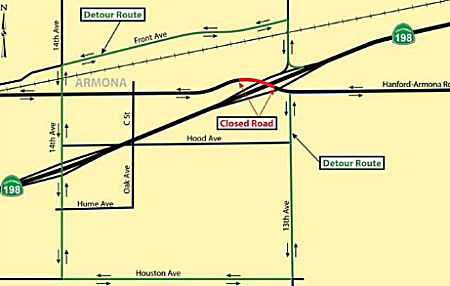 In May 2016, the CTC approved for future consideration of funding a project that will construct
a roundabout at the intersection of Hanford-Armona Road and 13th
Avenue near the city of Hanford (~ KIN R15.776). The project is programmed
in the 2014 State Highway Operation and Protection Program. The total
programmed amount is $6,434,000 for capital and support. Construction is
estimated to begin in Fiscal Year 2017-18. The scope, as described for the
preferred alternative, is consistent with the project scope programmed by
the Commission in the 2014 State Highway Operation and Protection Program.
A copy of the MND has been provided to Commission staff. The project will
result in less than significant impacts to the environment after
mitigation. The following resource area may be impacted by the project:
biological resources. Avoidance and minimization measures will reduce any
potential effects on the environment. These measures include, but are not
limited to, environmentally sensitive areas will be established for
nesting birds, burrowing owl, and San Joaquin kit fox, tree and vegetation
removal will be done outside nesting season, and replacement planting of
any disturbed Heritage oak trees.
In May 2016, the CTC approved for future consideration of funding a project that will construct
a roundabout at the intersection of Hanford-Armona Road and 13th
Avenue near the city of Hanford (~ KIN R15.776). The project is programmed
in the 2014 State Highway Operation and Protection Program. The total
programmed amount is $6,434,000 for capital and support. Construction is
estimated to begin in Fiscal Year 2017-18. The scope, as described for the
preferred alternative, is consistent with the project scope programmed by
the Commission in the 2014 State Highway Operation and Protection Program.
A copy of the MND has been provided to Commission staff. The project will
result in less than significant impacts to the environment after
mitigation. The following resource area may be impacted by the project:
biological resources. Avoidance and minimization measures will reduce any
potential effects on the environment. These measures include, but are not
limited to, environmentally sensitive areas will be established for
nesting birds, burrowing owl, and San Joaquin kit fox, tree and vegetation
removal will be done outside nesting season, and replacement planting of
any disturbed Heritage oak trees.
In January 2017, the CTC received an information report on 06-Kin-198 R15.5 Near Hanford, at the Hanford-Armona Road Undercrossing. Outcome/Output: Construct roundabout to reduce the number and severity of traffic collisions. There was a change in the CON ENG budget from $806,000 to $875,000. The original allocation of $4,688,000 was 12/18/2017.
In September 2018, Caltrans District 6 tweeted that
there would be a seven week closure at the Hanford-Armona Road
Undercrossing for construction of a roundabout. The intersection was
scheduled to be reopened on 11/16/2018. The closure would include the WB
Route 198 on-ramp.
(Source: Caltrans District 4 on Facebook, 9/27/2018)
In March 2014, the CTC authorized relinquishment of right of way in the city of Hanford along Route 198 at 12th Avenue and Hayden Avenue, consisting of a reconstructed city street (06-Kin-198-PM R16.9). The City, by letter dated December 10, 2013, waived the 90-day notice requirement and agreed to accept title upon relinquishment by the State.
In January 2021, the CTC authorized relinquishment of right of way,
consisting of collateral facilities, in the city of Hanford along Route 198 on 12th Avenue and the Union Pacific Railroad Crossing
(06-Kin-198-PM 16.91). Looking at the relinquishment map, this is the
intersection of 12th Ave and the UP trackage. The City agreed
to waive the 90-day notice requirement and accept title upon
relinquishment by the State by letter dated October 28, 2020.
(Source: January 2021 CTC Agenda, Agenda Item 2.3c)
In December 2017, the CTC authorized relinquishment of right of way in the city of Hanford along Route 198 on 12th Avenue (06-Kin-198-PM R16.91), consisting of collateral facilities. The City, by Relinquishment Agreement dated August 12, 2016 and Amendment № 1 to Agreement 06-1602 dated July 12, 2017, agreed to waive the 90-day notice requirement and accept title upon relinquishment by the State.
Route 198 and 9th Avenue Interchange (06-Kin-198 R19.1/R20.5)
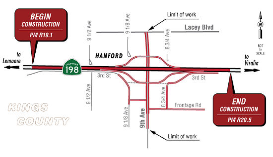 In March 2024, the CTC adopted the 2024 STIP, which included the following as new
2024 programming: Route 198 (PPNO 06-7054; ~ KIN R19.967) "SR 198 and 9th
Avenue Interchange". Programming × $1000: $4,500 FY24-25 PA&ED.
In March 2024, the CTC adopted the 2024 STIP, which included the following as new
2024 programming: Route 198 (PPNO 06-7054; ~ KIN R19.967) "SR 198 and 9th
Avenue Interchange". Programming × $1000: $4,500 FY24-25 PA&ED.
(March 2024 CTC Agenda, Agenda Item 4.5 and Caltrans STIP Page)
In December 2024, the CTC approved the following 2024
STIP allocation: $4,500,000. Department of Transportation Kings
County Association of Governments 06-Kin-198 R19.1/R20.5. PPNO
06-7054; ProjID 0619000203; EA 1A200. SR 198 and 9th
Avenue Interchange. On Route 198 in Kings County, between 0.1-mile
East of 10th Ave. Overcrossing and 0.6-mile West of Route 43/Route 198 Separation. Upgrade a 1.4-mile section of expressway to
freeway by replacing the at-grade intersection at 9th Ave. and
Route 198 in Kings County in the City of Hanford with an interchange.
Allocation PA&ED $4,500,000.
(Source: December 2024 CTC Agenda, Agenda Item 2.5c.(1) #2)
In October 2025, it was reported that Caltrans was
holding public scoping meetings for a forthcoming EIR, including the
availability of the Notice of Preparation. The project proposes to ppgrade
a 1.4-mile section of expressway to freeway by replacing the at-grade
intersection at 9th Ave. and Route 198 in Kings County in the
City of Hanford with an interchange. Five alternatives were being
considered for the project. The build alternatives being considered are:
(Source: Caltrans District 6 on FB, 10/8/2025; Caltrans Project Page, retrieved 12/19/2025)
In March 2026, the CTC adopted the 2026 STIP, which
included the following as continued programming from 2024: PPNO 06-7054,
“SR 198 and 9th Avenue Interchange”. Prior years
programming ($ × 1000): $4,500 ($4,500 PA&ED). 2026 and Future
Programming ($ × 1000): None
(Source: March 2026 CTC Agenda, Agenda Item 4.4; 2026 STIP Staff Recommendations Adopted 2/27/2026)
Hanford to Route 99 Expressway (~ KIN R21.449 to ~ TUL R3.448R)
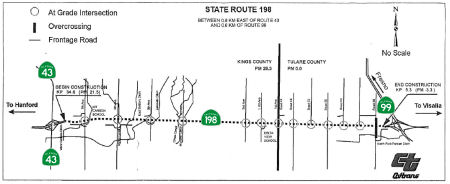 In May 2001, the CTC considered TCRP Project #111, which
will build 10mi of 4-lane expressway from Route 99 to Hanford in Kings and
Tulare counties. The basic approach will be to widen the two-lane
conventional highway to a four-lane expressway on Route 198 from east of
Route 43 near Hanford to west of Route 99 near Visalia. The project is
estimated to cost a total of $55.3 million. The regional transportation
planning agencies in both Kings and Tulare Counties and the State have
already funded $17.5 million for environmental review, design and right of
way phases. The project will be funded with $14.0 million in the
Governor’s Transportation Congestion Relief Program (TCRP). In 2007,
the CTC authorized an additional $22.912 million in funding from the
Corridor Mobility Improvement Account, out of $28.640 million requested)
[for the Tulare County portion] and $48.688 million (ouf of $60.860
million requested) [for the Kings County portion].
In May 2001, the CTC considered TCRP Project #111, which
will build 10mi of 4-lane expressway from Route 99 to Hanford in Kings and
Tulare counties. The basic approach will be to widen the two-lane
conventional highway to a four-lane expressway on Route 198 from east of
Route 43 near Hanford to west of Route 99 near Visalia. The project is
estimated to cost a total of $55.3 million. The regional transportation
planning agencies in both Kings and Tulare Counties and the State have
already funded $17.5 million for environmental review, design and right of
way phases. The project will be funded with $14.0 million in the
Governor’s Transportation Congestion Relief Program (TCRP). In 2007,
the CTC authorized an additional $22.912 million in funding from the
Corridor Mobility Improvement Account, out of $28.640 million requested)
[for the Tulare County portion] and $48.688 million (ouf of $60.860
million requested) [for the Kings County portion].
The SAFETEA-LU act, enacted in August 2005 as the reauthorization of TEA-21, provided the following expenditures on or near this route:
In 2007, the CTC did not recommend funding the 19th Ave. interchange and freeway conversion in Kings County ($27,770K requested) from the Corridor Mobility Improvement Account (CMIA).
In October 2008, the CTC received a mitigated negative declaration regarding the widening of Route 198 in Kings and Tulare Counties from 0.5 miles east of Route 43 near Hanford to 0.4 miles west of Route 99 near Visalia. The project is programmed with Corridor Mobility Improvement Account, Regional Improvement Program, Interregional Improvement Program, Traffic Congestion Relief Program, and federal demonstration funds. The total estimated project cost, capital and support, is $124.5 million. Construction is estimated to begin in Fiscal Year 2009-10. The project will involve construction activities resulting in a reduction in prime farmland and visual impacts that will be mitigated to less than significant levels.
In April 2010 the CTC approved for future consideration of funding a project in Kings County that will construct improvements to the interchange of 12th Avenue and Route 198 in the city of Hanford, including the widening of the existing overpass and ramps on Route 198. The project is fully funded in the 2008 State Transportation Improvement Program and includes local funds. Total estimated project cost is $23,300,000 for capital and support. Construction is estimated to begin in Fiscal Year 2011-12. The project will involve construction activities resulting in impacts to the habitat of the San Joaquin kit fox, a Federally listed threatened species. In addition visual impacts in the form of tree removal are associated with the project.
In December 2012, Caltrans celebrated the ceremonial completion of the Hanford Expressway project. The $60 million project converted 10 miles of Route 198 from a two-lane highway to a four-lane divided expressway, extending from Route 43 to Route 99 in Kings and Tulare counties. Construction began in November 2009.
In May 2015, the CTC authorized relinquishment of right of way in the county of Kings along Route 198 between 1st Avenue and 8th Avenue (Route 43), consisting of reconstructed county roads and newly constructed frontage roads (06-Kings-198-PM T21.65/28.32). This is along the portion E Hanford between Route 43 and Route 99. and Route 99. It also authorized the vacation of right of way in the county of Kings along Route 198 between 2nd Avenue and 7th Avenue, consisting of superseded highway right of way no longer needed for State highway purposes (06-Kings-198-PM 22.73/27.34).
In March 2014, the CTC authorized relinquishment of right of way in the county of Tulare along Route 198 from the Kings and Tulare County line to Route 99 (06-Tul-198-PM 0.00/R3.27), consisting of intersection improvements and newly constructed frontage roads.
In March 2014, the CTC vacated right of way in the county of Tulare along Route 198 from the Kings and Tulare County line to Route 99 (06-Tul-198-PM 0.00/3.02), consisting of superseded highway right of way no longer needed for State highway purposes. The County, was given a 90-day notice of intent to vacate, without protesting such action.
In September 2006, the CTC considered relinquishment of right of way in the County of Tulare, at Avenue 296, consisting of reconstructed and relocated county road. (6-Tul-198-PM 21.9 (KP 35.23))
Naming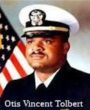 The portion between 25th Avenue and 18th Avenue (~ KIN 3.022 to KIN R10.553) near Lemoore is named
the "United States Navy Lieutenant Commander Otis Vincent Tolbert
Memorial Highway". Named in honor of the United States Navy
Lieutenant Commander Otis Vincent Tolbert, a long-time Lemoore resident
who was killed during the terrorist attacks on the Pentagon on September
11, 2001. The segment of highway named, from 18th Avenue to 25th
Avenue in Lemoore, directly correlates to his life, starting at Lemoore
High School, his alma mater, and ending at the Lemoore Naval Air Station.
LTC Tolbert graduated from Lemoore High School in 1990, where he was a
track and field star. He was awarded a football scholarship to California
State University, Fresno (CSUF), where he played defensive end for the
Fresno State Bulldogs football team. He graduated in 1985 with a degree in
criminal justice, and joined the United States Navy, where he advanced to
the rank of Lieutenant Commander for the Defense Intelligence Agency.
Named by Senate Concurrent Resolution 35, Chapter 51, May 5, 2004.
The portion between 25th Avenue and 18th Avenue (~ KIN 3.022 to KIN R10.553) near Lemoore is named
the "United States Navy Lieutenant Commander Otis Vincent Tolbert
Memorial Highway". Named in honor of the United States Navy
Lieutenant Commander Otis Vincent Tolbert, a long-time Lemoore resident
who was killed during the terrorist attacks on the Pentagon on September
11, 2001. The segment of highway named, from 18th Avenue to 25th
Avenue in Lemoore, directly correlates to his life, starting at Lemoore
High School, his alma mater, and ending at the Lemoore Naval Air Station.
LTC Tolbert graduated from Lemoore High School in 1990, where he was a
track and field star. He was awarded a football scholarship to California
State University, Fresno (CSUF), where he played defensive end for the
Fresno State Bulldogs football team. He graduated in 1985 with a degree in
criminal justice, and joined the United States Navy, where he advanced to
the rank of Lieutenant Commander for the Defense Intelligence Agency.
Named by Senate Concurrent Resolution 35, Chapter 51, May 5, 2004.
(Image source: Tom Uribes on Twitter)
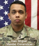 The portion of Route 198 between 18th Avenue
(KER R10.561) and 14th Avenue (KER R14.767) in the City of
Hanford in the County of Kings is named the “Army Specialist
Juan Miguel Mendez Covarrubias Memorial Highway”. It was
named in memory of United States Army Specialist Juan Miguel Mendez
Covarrubias of Hanford, California, who was killed in action on March 11,
2020, in a rocket attack on Camp Taji, Iraq. Mendez Covarrubias was
assigned to 1st Battalion, 227th Aviation Regiment,
1st Air Cavalry Brigade, 1st Cavalry Division, Fort
Hood, Texas. Mendez Covarrubias entered the United States Army in June
2018 as a signal support systems specialist. In March 2019, Mendez
Covarrubias had been assigned to 1st Cavalry Division at Fort
Hood. Mendez Covarrubias deployed in support of the Inherent Resolve
mission in October, 2019. Mendez Covarrubias' awards and decorations
include the Global War on Terrorism Medal, National Defense Service Ribbon
and Army Service Ribbon. Named by Assembly Resolution ACR 157, Res. Chapter 134, 08/19/22.
The portion of Route 198 between 18th Avenue
(KER R10.561) and 14th Avenue (KER R14.767) in the City of
Hanford in the County of Kings is named the “Army Specialist
Juan Miguel Mendez Covarrubias Memorial Highway”. It was
named in memory of United States Army Specialist Juan Miguel Mendez
Covarrubias of Hanford, California, who was killed in action on March 11,
2020, in a rocket attack on Camp Taji, Iraq. Mendez Covarrubias was
assigned to 1st Battalion, 227th Aviation Regiment,
1st Air Cavalry Brigade, 1st Cavalry Division, Fort
Hood, Texas. Mendez Covarrubias entered the United States Army in June
2018 as a signal support systems specialist. In March 2019, Mendez
Covarrubias had been assigned to 1st Cavalry Division at Fort
Hood. Mendez Covarrubias deployed in support of the Inherent Resolve
mission in October, 2019. Mendez Covarrubias' awards and decorations
include the Global War on Terrorism Medal, National Defense Service Ribbon
and Army Service Ribbon. Named by Assembly Resolution ACR 157, Res. Chapter 134, 08/19/22.
(Image source: CBS News)
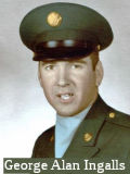 The portion that passes through the City of Hanford between Twelfth Avenue and Seventh Avenue (~ KIN R16.901 to KIN 22.315) in
Hanford is named the "George Alan Ingalls Memorial Highway". George
Alan Ingalls was born on March 9, 1946, in Hanford, California. He entered
the United States Army at Los Angeles, California, obtained the rank of
Specialist Fourth Class, and was assigned to Company A, Second Battalion,
Fifth Calvary, First Calvary Division (Airmobile). He served in Vietnam,
and on April 16, 1967, near Duc Pho, Republic of Vietnam, George Alan
Ingalls, in a spontaneous act of great courage, which cost him his own
life, threw himself on top of a hand grenade, thereby abating the
grenade's full blast and saving the lives of the members of his squad. He
was awarded the Medal of Honor posthumously on January 30, 1969; on
November 11, 2000, American Legion Post 3 of Hanford appropriately honored
George Alan Ingalls' mother and family members at the tank memorial in the
Hanford Cemetery. Named by Assembly Concurrent Resolution 47, Resolution
Chapter 60, filed June 4, 2001.
The portion that passes through the City of Hanford between Twelfth Avenue and Seventh Avenue (~ KIN R16.901 to KIN 22.315) in
Hanford is named the "George Alan Ingalls Memorial Highway". George
Alan Ingalls was born on March 9, 1946, in Hanford, California. He entered
the United States Army at Los Angeles, California, obtained the rank of
Specialist Fourth Class, and was assigned to Company A, Second Battalion,
Fifth Calvary, First Calvary Division (Airmobile). He served in Vietnam,
and on April 16, 1967, near Duc Pho, Republic of Vietnam, George Alan
Ingalls, in a spontaneous act of great courage, which cost him his own
life, threw himself on top of a hand grenade, thereby abating the
grenade's full blast and saving the lives of the members of his squad. He
was awarded the Medal of Honor posthumously on January 30, 1969; on
November 11, 2000, American Legion Post 3 of Hanford appropriately honored
George Alan Ingalls' mother and family members at the tank memorial in the
Hanford Cemetery. Named by Assembly Concurrent Resolution 47, Resolution
Chapter 60, filed June 4, 2001.
(Image source: VVMF Wall of Faces)
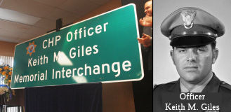 The interchange at Route 43 and Route 198 (~ KIN
R21.449) in the County of Kings is named the "CHP Officer Keith M.
Giles Memorial Interchange". Keith Melvin Giles was born in July
1940, to Melvin and Thelma Giles, in Tulare, California. Keith Giles had
three siblings: Gary, who was Keith’s twin brother, Linda, and Greg.
Keith Giles graduated from Corcoran High School in 1957, graduated from
the College of the Sequoias shortly thereafter, and also attended Fresno
State College. Keith Giles proudly served in the United States Army from
1963 to 1965 and achieved the rank of corporal. Prior to becoming a
California Highway Patrol officer, Keith Giles worked as a farmer and was
actively involved in the community. Officer Giles graduated from the
California Highway Patrol Academy on May 28, 1970, with CTC I-70 and, upon
graduation, he was assigned to the Santa Fe Springs Area where he proudly
served for approximately four years. Officer Giles, badge number 7403, was
killed in the line of duty on August 25, 1974, while making a traffic stop
shortly after 2:00 a.m. He was standing on the left side of the stopped
vehicle when a passing car drifted over the edge of the roadway and struck
him, killing him almost instantly. The errant driver apparently dozed off
and may have been under the influence of alcohol. Officer Giles was a
hardworking, dedicated officer who loved his job and enjoyed the people he
worked with. He was known for his devotion to his family and his love of
law enforcement. Named by Assembly Concurrent Resolution (ACR) 159, Res.
Chapter 123, Statutes of 2016, on August 16, 2016.
The interchange at Route 43 and Route 198 (~ KIN
R21.449) in the County of Kings is named the "CHP Officer Keith M.
Giles Memorial Interchange". Keith Melvin Giles was born in July
1940, to Melvin and Thelma Giles, in Tulare, California. Keith Giles had
three siblings: Gary, who was Keith’s twin brother, Linda, and Greg.
Keith Giles graduated from Corcoran High School in 1957, graduated from
the College of the Sequoias shortly thereafter, and also attended Fresno
State College. Keith Giles proudly served in the United States Army from
1963 to 1965 and achieved the rank of corporal. Prior to becoming a
California Highway Patrol officer, Keith Giles worked as a farmer and was
actively involved in the community. Officer Giles graduated from the
California Highway Patrol Academy on May 28, 1970, with CTC I-70 and, upon
graduation, he was assigned to the Santa Fe Springs Area where he proudly
served for approximately four years. Officer Giles, badge number 7403, was
killed in the line of duty on August 25, 1974, while making a traffic stop
shortly after 2:00 a.m. He was standing on the left side of the stopped
vehicle when a passing car drifted over the edge of the roadway and struck
him, killing him almost instantly. The errant driver apparently dozed off
and may have been under the influence of alcohol. Officer Giles was a
hardworking, dedicated officer who loved his job and enjoyed the people he
worked with. He was known for his devotion to his family and his love of
law enforcement. Named by Assembly Concurrent Resolution (ACR) 159, Res.
Chapter 123, Statutes of 2016, on August 16, 2016.
(Image sources: Hanford Sentinel)
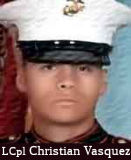 The portion of Route 198 between
Sixth Avenue and the Kings County line (~ KIN 23.32 to KIN 28.32) in the
Kings County is named the "Christian Vasquez Memorial Highway".
It was named in memory of Lance Corporal Christian Vasquez, who was born
in the City of Hanford on July 11, 1987, and grew up in the City of
Coalinga. Lance Corporal Vasquez attended Dawson Elementary School,
Coalinga Middle School, and Coalinga High School, class of 2006. Lance
Corporal Vasquez, like his brother Danny, always wanted to become a Marine
and, enlisted in the United States Marine Corps one week after his high
school graduation. Lance Corporal Vasquez joined the Marine Corps to
enable his mother to stay at home and care for his baby brother. Lance
Corporal Vasquez aspired to become a doctor, as others in his family had,
and hoped to attend medical school in Texas. Lance Corporal Vasquez was
killed in action in the province of Al Anbar, Iraq on August 2, 2007. It
was named in recognition of Lance Corporal Vasquez’s service and
sacrifice. Named by Assembly Concurrent Resolution 100, Resolution Chapter
109, on September 4, 2012.
The portion of Route 198 between
Sixth Avenue and the Kings County line (~ KIN 23.32 to KIN 28.32) in the
Kings County is named the "Christian Vasquez Memorial Highway".
It was named in memory of Lance Corporal Christian Vasquez, who was born
in the City of Hanford on July 11, 1987, and grew up in the City of
Coalinga. Lance Corporal Vasquez attended Dawson Elementary School,
Coalinga Middle School, and Coalinga High School, class of 2006. Lance
Corporal Vasquez, like his brother Danny, always wanted to become a Marine
and, enlisted in the United States Marine Corps one week after his high
school graduation. Lance Corporal Vasquez joined the Marine Corps to
enable his mother to stay at home and care for his baby brother. Lance
Corporal Vasquez aspired to become a doctor, as others in his family had,
and hoped to attend medical school in Texas. Lance Corporal Vasquez was
killed in action in the province of Al Anbar, Iraq on August 2, 2007. It
was named in recognition of Lance Corporal Vasquez’s service and
sacrifice. Named by Assembly Concurrent Resolution 100, Resolution Chapter
109, on September 4, 2012.
(Image source: Iraq/Afghanistan War Heroes)
 Named Structures
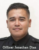 The 19th Avenue overcrossing on Route 198 in the City of Lemoore (~ KIN R9.474) in the
County of Kings is named the "Officer Jonathan Diaz Memorial
Overcrossing". It was named in memory of Officer Jonathan Diaz, who
was a graduate of Coalinga High School and West Hills College, where he
earned an associate’s degree in criminal justice. Officer Jonathan
Diaz began his law enforcement career in his hometown of Huron,
California, as a reserve police officer with the Huron Police Department
where he investigated numerous complex cases and earned Officer of the
Year in 2015. Diaz was hired by the Lemoore Police Department in August
2016 and was an asset to the community. Diaz received numerous
commendations from the Lemoore Police Department, including being selected
to be the Recruit Training Officer for the Tulare-Kings Counties Basic
Peace Officer Academy and a Field Training Officer for the Lemoore Police
Department. Diaz displayed an eagerness to go above and beyond on his
assigned calls and his thoroughness and outstanding investigative skills
resulted in arrests for possession of loaded firearms and controlled
substances. In addition to helping to keep the City of Lemoore safe,
Officer Jonathan Diaz mentored at-promise youth of Lemoore through the
Youth Adult Awareness Program and other programs. Officer Jonathan
Diaz’s actions, professionalism, and dedication to his duties and to
the citizens of Lemoore never went unnoticed. In September 2018, Officer
Jonathan Diaz was awarded Lemoore Police Department’s Public Safety
Officer of the Year and a couple months later he earned the position of
Gang Investigator for the Kings County Major Crimes Task Force. Sadly,
Officer Jonathan Diaz was fatally shot while off-duty after he intervened
to stop an act of domestic violence. Named by Senate Concurrent Resolution
(SCR) 86, Res. Chapter 33, 09/11/20.
The 19th Avenue overcrossing on Route 198 in the City of Lemoore (~ KIN R9.474) in the
County of Kings is named the "Officer Jonathan Diaz Memorial
Overcrossing". It was named in memory of Officer Jonathan Diaz, who
was a graduate of Coalinga High School and West Hills College, where he
earned an associate’s degree in criminal justice. Officer Jonathan
Diaz began his law enforcement career in his hometown of Huron,
California, as a reserve police officer with the Huron Police Department
where he investigated numerous complex cases and earned Officer of the
Year in 2015. Diaz was hired by the Lemoore Police Department in August
2016 and was an asset to the community. Diaz received numerous
commendations from the Lemoore Police Department, including being selected
to be the Recruit Training Officer for the Tulare-Kings Counties Basic
Peace Officer Academy and a Field Training Officer for the Lemoore Police
Department. Diaz displayed an eagerness to go above and beyond on his
assigned calls and his thoroughness and outstanding investigative skills
resulted in arrests for possession of loaded firearms and controlled
substances. In addition to helping to keep the City of Lemoore safe,
Officer Jonathan Diaz mentored at-promise youth of Lemoore through the
Youth Adult Awareness Program and other programs. Officer Jonathan
Diaz’s actions, professionalism, and dedication to his duties and to
the citizens of Lemoore never went unnoticed. In September 2018, Officer
Jonathan Diaz was awarded Lemoore Police Department’s Public Safety
Officer of the Year and a couple months later he earned the position of
Gang Investigator for the Kings County Major Crimes Task Force. Sadly,
Officer Jonathan Diaz was fatally shot while off-duty after he intervened
to stop an act of domestic violence. Named by Senate Concurrent Resolution
(SCR) 86, Res. Chapter 33, 09/11/20.
(Image source: Lemoore Leader)
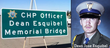 The Cross Creek Bridge, Bridge No. 45-0006 (~ KIN 25.171), on Route 198, in the County of Kings,
is officially named the "CHP Officer Dean Esquibel Memorial Bridge".
It was named on 9/27/13 by ACR 69, Res. Chapter 143, Statutes of 2013. It
was named in memory of CHP Officer Dean Jose Esquibel, who was born in
July 1962 in Greensboro, North Carolina. Officer Esquibel graduated from
Orosi High School in 1980, joined the Police Academy through the College
of the Sequoias shortly thereafter, and was assigned to the Orange Cove
Police Department upon graduation. Officer Esquibel worked as an Orange
Cove Police Officer and did undercover work for the Dinuba Police
Department prior to becoming a California Highway Patrol Officer. Officer
Dean Esquibel married in June 1981. Officer Esquibel entered the
Department of the California Highway Patrol Academy on April 2, 1984, and
upon graduation was assigned to the Hanford Area Office, where he proudly
served the department for approximately one year. While providing backup
in a high-speed pursuit of a fleeing motorcyclist on Route 198, Officer
Esquibel was forced to veer off the road, causing his patrol car to burst
into flames. The impact of the collision pinned Officer Esquibel inside
his patrol car, and, although he was rescued by fellow CHP Officer De La
Cruz shortly thereafter, Officer Esquibel succumbed to his injuries two
weeks later on August 21, 1985.
The Cross Creek Bridge, Bridge No. 45-0006 (~ KIN 25.171), on Route 198, in the County of Kings,
is officially named the "CHP Officer Dean Esquibel Memorial Bridge".
It was named on 9/27/13 by ACR 69, Res. Chapter 143, Statutes of 2013. It
was named in memory of CHP Officer Dean Jose Esquibel, who was born in
July 1962 in Greensboro, North Carolina. Officer Esquibel graduated from
Orosi High School in 1980, joined the Police Academy through the College
of the Sequoias shortly thereafter, and was assigned to the Orange Cove
Police Department upon graduation. Officer Esquibel worked as an Orange
Cove Police Officer and did undercover work for the Dinuba Police
Department prior to becoming a California Highway Patrol Officer. Officer
Dean Esquibel married in June 1981. Officer Esquibel entered the
Department of the California Highway Patrol Academy on April 2, 1984, and
upon graduation was assigned to the Hanford Area Office, where he proudly
served the department for approximately one year. While providing backup
in a high-speed pursuit of a fleeing motorcyclist on Route 198, Officer
Esquibel was forced to veer off the road, causing his patrol car to burst
into flames. The impact of the collision pinned Officer Esquibel inside
his patrol car, and, although he was rescued by fellow CHP Officer De La
Cruz shortly thereafter, Officer Esquibel succumbed to his injuries two
weeks later on August 21, 1985.
(Image source: My Lemoore Leader; CHP - Hanford Officer Dean Esquibel Memorial Page (Facebook))
Scenic Route[SHC 263.8] From Route 33 near Oilfields to Route 5.
Although this segment is eligible for Scenic Highway status, it has not yet met the criteria to be officially designated as Scenic Highway.
 Freeway
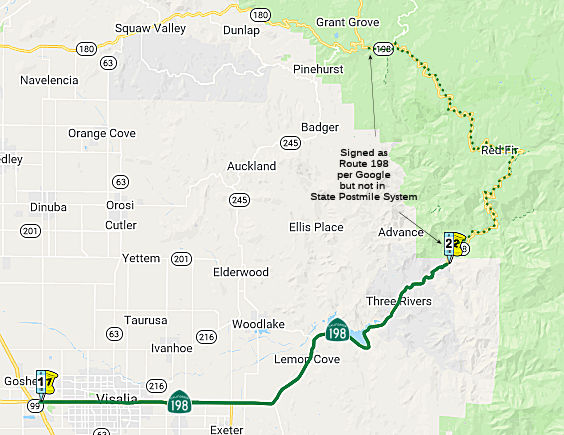 From Route 99 to the Sequoia National Park line via Visalia.
Post 1964 Signage HistoryThis segment remains as defined in 1963.
Despite what Google thinks on their map images, The Generals Highway is a 46 mile National Park highway, and is not part of Route 198 but more or less acts as a continuation of it. The Generals Highway lies entirely within Tulare County and crosses through portions of the Giant Sequoia National Monument within Sequoia National Forest. For more information on The Generals Highway, see the Gribblenation Blog: “The Generals Highway; connecting Kings Canyon National Park and Sequoia National Park”
Pre 1964 Signage HistoryThis route was all LRN 10. The portion between Hanford and Route 99 was defined in 1909. The portion from US 101 to Hanford was defined in 1915, and the remainder (Route 99 to Sequoia National Park) was defined in 1919. In 1934, Route 198 was signed from Jct. US 101 at San Lucas to Sequoia National Park via Coalinga.
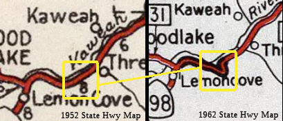 The Gribblenation Blog “Former California State Route 198 at the bottom of Lake Kaweah” (Tom Fearer) provides more information on for former routing that is now
under Lake Kaweah (~ TUL 31.211). In 1919, the Third State Highway Bond
Act extended LRN 10 east from Visalia to the Colony Mill Road of Sequoia
National Park by way of the existing road along the Kaweah River; it first
appears on the State Highway Map in 1920. In 1932, a new highway alignment
was placed up for construction bidding along LRN 10 from Lemon Cove to
Three Rivers. This new alignment of LRN 10 was to be 8.5 miles in length
and would shorten the existing highway by 1.1 miles but way of eliminating
unnecessary curves. This was awarded in 1932; LRN 10 became Route 198 in
1934. The 1935 state highway map shows the initial routing of Route 198
from Lemon Cove east to Three Rivers via what is now Lake Kaweah, and near
what was the community of Terminus (~ TUL 29.454). The term "was" is
appropriate, the Terminus Dam was authorized a Army Corps of Engineers
project as part of the Flood Control Act of 1944. In 1948 as plans for the
Terminus Dam were being finalized when a archaeological survey determined
the Kaweah River was rich in local tribal artifacts. Excavations by
National Park Service Interagency Archaeological Salvage Program delayed
the start of the Terminus Dam project until the late 1950s; this also
delayed the relocation of Route 198 as the existing route was within the
planned lake that would form behind the dam. East of Lemon Cove Route 198
was realigned uphill at some point in 1961/1962. Tom did research to determine the likely routings and prepared a map; these routes can be hiked during dry spells.
The Gribblenation Blog “Former California State Route 198 at the bottom of Lake Kaweah” (Tom Fearer) provides more information on for former routing that is now
under Lake Kaweah (~ TUL 31.211). In 1919, the Third State Highway Bond
Act extended LRN 10 east from Visalia to the Colony Mill Road of Sequoia
National Park by way of the existing road along the Kaweah River; it first
appears on the State Highway Map in 1920. In 1932, a new highway alignment
was placed up for construction bidding along LRN 10 from Lemon Cove to
Three Rivers. This new alignment of LRN 10 was to be 8.5 miles in length
and would shorten the existing highway by 1.1 miles but way of eliminating
unnecessary curves. This was awarded in 1932; LRN 10 became Route 198 in
1934. The 1935 state highway map shows the initial routing of Route 198
from Lemon Cove east to Three Rivers via what is now Lake Kaweah, and near
what was the community of Terminus (~ TUL 29.454). The term "was" is
appropriate, the Terminus Dam was authorized a Army Corps of Engineers
project as part of the Flood Control Act of 1944. In 1948 as plans for the
Terminus Dam were being finalized when a archaeological survey determined
the Kaweah River was rich in local tribal artifacts. Excavations by
National Park Service Interagency Archaeological Salvage Program delayed
the start of the Terminus Dam project until the late 1950s; this also
delayed the relocation of Route 198 as the existing route was within the
planned lake that would form behind the dam. East of Lemon Cove Route 198
was realigned uphill at some point in 1961/1962. Tom did research to determine the likely routings and prepared a map; these routes can be hiked during dry spells.
(Source: Gribblenation Blog (Tom Fearer), “Former California State Route 198 at the bottom of Lake Kaweah”, January 2021)
StatusThe portion between Route 99 (~ TUL R4.246L) and Mooney Blvd. (~ TUL
R8.749) has been upgraded to freeway standards.
(Source: Gary Araki)
Freeway completion now goes from Route 99 (~ TUL R4.246L) to Road 168 (~ TUL R15.253) near Farmersville.
In July 2002, the CTC considered relinquishing the segment from PM TUL R4.8 to TUL R8.8 in the City of Visalia
In March 2026, the CTC adopted the 2026 STIP, which included the
following as new programming: PPNO 06-8113, “Rt 198/Rd 148, IC
Safety & Multimodal improvs” (06-Tul-65 R11.5/R14.0). Total
Programmed ($×1000): $4,990. 2026 and Future Programming
($×1000): $4,990 FY28-29. Programming Breakdown ($×1000): $4,990
(PA&ED), $0 (PS&E), $0 (Const), $0 (Con Sup), $0 (R/W), $0 (R/W
Sup). The project proposes to construct a new interchange at Road
148 and Route 198 in the City of Visalia in Tulare County. The interchange
will provide connections for vehicles, pedestrians, and active
transportation users, enhancing travel options for residents.
(Source: March 2026 CTC Agenda, Agenda Item 4.4; 2026 STIP Staff Recommendations Adopted 2/27/2026)
Route 198/Route 216 Junction Widening (TUL R11.71)
In September 2020, it was reported that CalTrans plans
to improve the interchange between Route 216 and Route 198. In May 2016,
Visalia and CalTrans staff held a joint public hearing to discuss
improvements to the interchange. In order to solve congestion at the
Lovers Lane interchange of Route 198, the city and (CalTrans) are
proposing improvements and changes at the intersections of Lovers Lane and
Noble Avenue, Lovers Lane and Route 198 eastbound ramp, Mineral King Ave
and Route 198 westbound ramp and Lovers Lane and Mineral King. Originally
proposed with a $60 million price tag in 2016 to close a portion of
Mineral King Ave affecting both homes and businesses, the current project
relies on a future planned highway interchange at Tower Road (Road 148),
less than a mile east of Lovers Lane to relieve congestion at the Lovers
Lane interchange. The new project is estimated to cost $21.5 million. The
California Transportation Commission approved for the design and
environmental phase of the project to be funded through the State Highway
Operation and Protection Program (SHOPP) fund. It is anticipated the
design and right-of-way for the project could be completed by early 2023,
with bidding and construction complete by the middle of 2025. The proposed
improvements include:
(Source: Sun Gazette, 9/16/2020)
In February 2022, it was reported that Lovers Lane
interchange improvements are on track to begin in fall 2023, with widening
of Lovers Lane slated to start in spring 2023. In May 2021, CalTrans
selected a plan to improve the interchange following several presentations
to the council and the Visalia community. Under the proposed plan, both
Buck Road and Mineral King Boulevard would dead-end at the interchange.
Westbound traffic exiting Route 198 would not stop until Lovers Lane,
which would be widened to four lanes of through traffic with left and
right turn lanes, and both the on and off ramps would be widened to two
lanes. At the May 2021 meeting, the city council was concerned residents
living north of the highway and east of Lovers Lane would be losing all
access to Lovers Lane unless they accessed Route 216 via McAuliff and Mill
Creek Parkway. In order to ease local residents into the realigned
interchange, a hybrid plan was developed allowing westbound Mineral King
Avenue to curve north of the current interchange and connect with Lovers
Lane at Duran Avenue, but Duran itself would end in a cul-de-sac just
before Lovers Lane to avoid cross traffic. However, the extension of
Mineral King would be for bike pedestrian access only and not to vehicles.
Buck Road would still be closed off at Mineral King and the westbound
offramp would extend to the much wider intersection at Mineral King and a
wider Lovers Lane. The project would require the city to take a
significant amount of land on the east side of Lovers Lane between Mineral
King and Duran. The interchange improvements are estimated to cost $19.7
million and Senan said the project is about $4 million short in
construction funding. The California Transportation Commission approved
for the design and environmental phase of the project to be funded through
the State Highway Operation and Protection Program (SHOPP) fund. It is
anticipated the design and right-of-way for the project could be completed
by early 2023, with bidding complete by summer 2023. Construction is
scheduled to begin in October 2023 and completed by January 2025. The
street rehabilitation project is estimated to cost about $26 million and
is slated to begin construction in the fall of 2023. The widening of
Lovers Lane is separate but related to CalTrans’ plan to improve the
interchange between two state routes, Route 216 and Route 198. The project
will widen Route 216 from Route 198 to Houston Avenue and widen Houston
Avenue from Lovers Lane to McAuliff Street as the state route leaves the
city toward Ivanhoe.
(Source: Visalia Sun Gazette, 2/2/2022)
In January 2025, it was reported that preliminary work
by Caltrans to reroute traffic exiting Route 198 at Lovers Lane (Route 216) has begun. Preparations will continue through the winter months, with
the project oing into high gear in March 2025. This includes permanently
blocking a portion of Mineral King east of Lovers Lane. This is just an
operational improvement. Caltrans plans to build a completely new
interchange just east of Lovers Lane at Road 148 that won’t be done
until 2035 at the earliest. The construction could take as long as two
years to complete. Drivers can expect lane closures, frequent delays and
long detours that route traffic deep into the neighborhoods of east
central Visalia. The intended result is an eventual safer and more
efficient movement of traffic, both on surface streets and at the
overcrowded Route 198 on and offramps. The east- and west-bound
interchanges of Lovers Lane and Route 198 will be remade during the course
of the project. New sidewalks and curbing are planned along Lovers Lane.
Retaining walls will be constructed. Finally Mineral King Avenue from
Lovers Lane east to Stapp Drive will be removed. That land will become the
new westbound ramps. The original construction schedule proposed by the
California Department of Transportation, put forward some time around
2020, would have seen the project begun in October 2023. Project
completion was anticipated by this month, January 2025. As indicated, the
project involves removing a portion of Mineral King Avenue. Traffic coming
into town from the east on the frontage road will be rerouted north at
McAuliff Street. Vehicles heading for Lovers Lane will then have to take
Mill Creek Parkway to get back on track. Avoiding this option would have
been far too costly and destructive, said Taylor. It would have led to the
demolition of the area’s key anchor businesses. Some living nearby
would also be displaced when their houses were leveled. Caltrans plans to
add “the ultimate improvement” – another interchange
just east of Lovers Lane at Road 148 – with a second project that
will be completed no earlier than 2035. City engineers hope the
improvements to the 198-Lovers Lane interchange made now will be enough to
keep traffic under control until 2035.
(Source: Valley Voice, 1/16/2025)
Lindsay Route 65 and Route 198/245 Operational Improvements Project (06-Tul-65, 29.0/R30.4; 06-Tul-198, R19.5/20.0; 06-Tul-245, 0.0/0.2)
There are also plans to construct a new expressway in Lindsey.
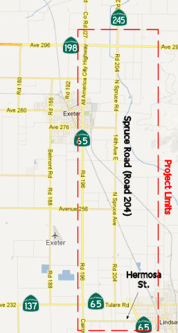 In December 2012,
the CTC reviewed a draft EIR regarding improvements on Route 65 and Route 245 in Tulare County to create the Tulare Expressway. The project will
realign Route 65 and construct a two-lane expressway on a four-lane right
of way for 9.3 miles from Hermosa Street in Lindsay to Avenue 300 on Route 245 northeast of Exeter (~ TUL 29.469 to TUL 39.539, 198 TUL R18.845 to
TUL R19.74, 245 TUL 0.000 to 245 TUL 0.514). There would also be about 0.5
miles of improvements on Route 245 starting at Route 198. The project is
not fully funded. The project is programmed in the 2012 State
Transportation Improvement Program. The total estimated cost for capital
and support is $102,711,000. Construction is estimated to begin in Fiscal
Year 2018-19. In addition to the no-build alternatives, there are two
alternatives being considered: Build Alternative 1 would parallel
the east and west side of existing Spruce Avenue depending on location; Build
Alternative 2 would project the west side of existing Spruce Avenue.
The project is needed to provide a continuous expressway through the
corridor. Existing Route 65 does not provide direct access to Route 245
for traffic wishing to continue NB. Currently NB traffic on Route 65 must
turn E at the Route 65/Route 198 intersection, enter a left turn lane, and
wait for a signal. Route 65 also passes through Exeter, resulting in
traffic flow interruptions with local traffic and the use of Spruce Road
(Road 204) as an alternative. This has increased the accident rate.
In December 2012,
the CTC reviewed a draft EIR regarding improvements on Route 65 and Route 245 in Tulare County to create the Tulare Expressway. The project will
realign Route 65 and construct a two-lane expressway on a four-lane right
of way for 9.3 miles from Hermosa Street in Lindsay to Avenue 300 on Route 245 northeast of Exeter (~ TUL 29.469 to TUL 39.539, 198 TUL R18.845 to
TUL R19.74, 245 TUL 0.000 to 245 TUL 0.514). There would also be about 0.5
miles of improvements on Route 245 starting at Route 198. The project is
not fully funded. The project is programmed in the 2012 State
Transportation Improvement Program. The total estimated cost for capital
and support is $102,711,000. Construction is estimated to begin in Fiscal
Year 2018-19. In addition to the no-build alternatives, there are two
alternatives being considered: Build Alternative 1 would parallel
the east and west side of existing Spruce Avenue depending on location; Build
Alternative 2 would project the west side of existing Spruce Avenue.
The project is needed to provide a continuous expressway through the
corridor. Existing Route 65 does not provide direct access to Route 245
for traffic wishing to continue NB. Currently NB traffic on Route 65 must
turn E at the Route 65/Route 198 intersection, enter a left turn lane, and
wait for a signal. Route 65 also passes through Exeter, resulting in
traffic flow interruptions with local traffic and the use of Spruce Road
(Road 204) as an alternative. This has increased the accident rate.
In November 2016, it was reported that the CTC/Caltrans
had “withdrawn from further consideration” its 2012 plan to
realign Route 65 between Exeter and Lindsay. Project Manager Judy
Aguilar-Luna said the project was being discontinued for a lack of funding
through the State Transportation Improvement Program. Instead Aguilar-Luna
said Caltrans will begin studying “essential improvements”
along the route. She said these will most likely be smaller projects that
can be completed one at a time, such as improving the intersection of
Route 245 and Route 198 near Exeter or changes to the intersections of
Hermosa Street and Oak Avenue along Route 65 in Lindsay. The decision to
stop the project is good news for Lindsay businesses that front the
current alignment of Route 65. Caltrans’ initial plan proposed
realigning Route 65 more closely with Spruce Road (Road 204) and away from
its current route along Road 196 (Kaweah204) and away from its current
route along Road 196 (Kaweah Avenue through Exeter). As part of the
realignment, the current highway would have become a frontage road and the
new highway would have been moved farther west away from the City and
businesses. The City of Lindsay became the first public agency to formally
oppose the Route 65 plan when the City Council approved a letter at its
July 9 meeting over concerns for its highway-adjacent businesses. In the
letter, then City Planner Bill Zigler stated the “awkwardly
configured frontage road” would provide little economic help to the
businesses north of the intersection of Hermosa. The city countered the
plan by proposing a Lindsay exit at Lindmore. The exit would have created
a one-way northbound frontage road along the current highway where it
splits into the new alignment and curves west away from the city. This
would have allowed vehicles to access the affected businesses. North of
Hermosa Street, the frontage road would became two lanes and connect to
the Oak Avenue extension, which was already part of initial project. It
would have also created new opportunities for the City to develop
commercial property that would have faced the new highway. And because
most of the land running along the west side of the current highway
already falls within Lindsay’s urban develop boundaries, the new
highway frontage would have been within the city’s sphere of
influence. The city later withdrew its own proposal after Caltrans said it
would have to condemn all of the properties (both homes and businesses
such as the 76 Station) on the west side of the freeway because Freemont
Drive would have created a dead-end road that exceeded the maximum length
set by the State. Transforming the current highway into a one-way,
northbound “Lindsay Exit” would have required making Fremont
Drive a cul-de-sac at the southern end near Lindmore. There is no
timetable to present the three-phase plan to make improvements along the
route. Once completed, Caltrans will circulate a new draft environmental
document for the replacement project. The draft document will be available
for review at an open forum public hearing and public notice will provided
for new comments.
(Source: Foothills Sun-Gazette, 11/9/2016)
The 2018 STIP, approved at the CTC March 2018 meeting, appears to adjust the allocation for PPNO 0104 Align Rd 204, Rt 65-Rt 198, 4 lanes, TUL 29.5/38.6. Near the city of Tulare, on Route 65 from Lindsay to Exeter, and on Road 204 from Route 137 to Route 198. Widen to 4 divided lanes and realign highway. The 2018 STIP changes the allocation from $3.150M to $5.650M.
The 2020 STIP, approved at the March 2020 CTC meeting,
continues the programming for PPNO 0104 Realignment & Operational
Improvements: $5,650K in prior years. It also adds a new PPNO 0104A
Realign & Op imprvmts (Oak St Roundabout), Phase 1, with programmed
funding of $1,500K in FY23-24.
(Source: March 2020 CTC Agenda, Item 4.7, 2020 STIP
Adopted 3/25/2020)
In March 2026, the CTC adopted the 2026 STIP, which
included the following as continued programming from 2024: PPNO 06-0104,
“Realignment & Operational Improvements”. Total Programmed
($×1000): $5,650. Prior years programming ($×1000): $5,650. 2026
and Future Programming ($×1000): $0. Programming Breakdown
($×1000): $5,650 (PA&ED), $0 (PS&E), $0 (Const), $0 (Con
Sup), $0 (R/W), $0 (R/W Sup).
(Source: March 2026 CTC Agenda, Agenda Item 4.4; 2026 STIP Staff Recommendations Adopted 2/27/2026)
In March 2026, the CTC adopted the 2026 STIP, which
included the following as continued programming from 2024: PPNO 06-0104A,
“Realign & Op imprvmts (Oak St Roundabout), Phase 1”.
Total Programmed ($×1000): $22,650. Prior years programming
($×1000): $2,500. 2026 and Future Programming ($×1000): $20,150
FY27-28. Programming Breakdown ($×1000): $0 (PA&ED), $2,500
(PS&E), $17,200 (Const), $2,950 (Con Sup), $0 (R/W), $0 (R/W Sup).
(Source: March 2026 CTC Agenda, Agenda Item 4.4; 2026 STIP Staff Recommendations Adopted 2/27/2026)
March 2026 review of the DRAFT 2026 SHOPP identified
the following new project: 06-Tul-198 R19.5/20.0. PPNO 06-8119; ProjID
0624000207; EA 1H130. Route 198 Near Exeter, from 0.3 mile south to 0.2
mile north of Route 245. Construct roundabout intersection with
sidewalks, curb ramps, drainage system, and lighting. Allocation ($ ×
1,000): PA&ED —; PS&E $2,250; R/W Sup $475; Con Sup $2,300;
R/W Cap $1,100; Const Cap $12,293; TOTAL $18,418. Begin Const: 3/29/2030.
(Source: Caltrans SHOPP Page: DRAFT 2026 SHOPP PROPOSED, State Highway Operation and Protection Program, Fiscal Years 2026-27 through 2029-30
(PDF), January 31, 2026; March 2026 CTC Agenda, Agenda Item 4.7)
In June 2026, the CTC approved for future consideration
of funding the Lindsay Route 65 and Route 198/245 Operational
Improvements Project: Route 65, Route 198, and Route 245 in Tulare
County. Make operational improvements on Route 65 from PM 29.0 to R30.4,
Route 198 from PM R19.5 to 20.0, and Route 245 from PM 0.0 to 0.2, in
Tulare County. Specifically, the project includes, in the City of Lindsay,
construction of a roundabout on Route 65 near Tulare Road, realignment of
Route 65 from Avenue 224 (Lindmore Street) to just east of Cedar Avenue,
and construction of roundabouts on the new alignment at Hermosa Street and
the Route 65 connection; near the City of Exeter, the project includes
construction of a roundabout at the junction of Route 198 and Route 245. (06-Tul-65,
29.0/R30.4; 06-Tul-198, R19.5/20.0; 06-Tul-245, 0.0/0.2; PPNO 06-0104A).
The project is currently programmed in the 2026 State Transportation
Improvement Program (STIP) and the Senate Bill 1 Local Partnership Program
for Plans, Specifications and Estimate, Right of Way (Support and Capital)
and Construction (Support and Capital) for $28,405,000. Construction will
begin in 2027-28. The scope, as described for the preferred alternative,
is consistent with the project scope as programmed by the Commission in
the 2026 STIP. The project will result in less than significant impacts to
the environment.
(Source: June 2026 CTC Agenda, Agenda Item 2.2c.(1) #2)
In June 2026, the CTC approved a request for an
additional $105,000 for the Route 65 Realignment & Operational
Improvements (Oak St Roundabout), Location 1 Phase I project to complete
the Plans, Specifications, and Estimate (PS&E) phase. The project
proposes to construct a roundabout. The project realized cost increases
due to additional design work that is required for proposed scope. A
project change request has been submitted and is pending approval.
It proposes to increase the project limits to tie into the existing
pavement at a more suitable location; and revise the scope by adding two
drainage basins, incorporating sidewalk improvements, additional
landscaping requested by the City, expanding utility relocation limits to
meet the Lindmore Irrigation District’s requirements, and adding an
enhanced median per the recommendation from the Department’s Traffic
Operations office. These changes will make for a better project and
minimize disruptions caused by having multiple projects.
(Source: June 2026 CTC Agenda, Agenda Item 2.5s.(16))
$105,000. 06-Tul-65 29.7 29.6/30.3.
PPNO 06-0104A; ProjID 0620000059; EA 43081. SR 65 Realignment &
Operational Improvements (Oak St Roundabout), Location 1 Phase I.
Construct a roundabout In Lindsay from 0.1 mile south of Mariposa St. to
Cedar Ave. Supplemental funds are needed to complete PS&E. CEQA - ND,
12/07/2023; Re-validation 05/07/2025 NEPA - EIS, 12/07/2023; Re-validation
05/07/2025. Concurrent consideration of funding under Resolution E-26-32;
June 2026. Concurrent LPP (Formulaic) Programming Amendment under
Resolution LPP-P-2526-17; June 2026. Contribution from other sources:
$1,195,000. Breakdown: PS&E $2,500,000 + $105,000 = $2,605,000.
In August 2011, the CTC approved $508,000 in SHOPP funding for repairs in Lemon Cove, at the Lemon Cove Maintenance Station (~ TUL 26.257), that will excavate contaminated soil at one location to improve ground water quality and comply with local regulations.
Naming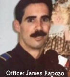 The portion of Route 198 between
Route 99 and Route 245 near Lindcove (~ TUL R4.246L to TUL T19.779) is
named the "Officer James Rapozo Memorial Freeway". Jim Rapozo began
his law enforcement career with the Hanford Police Department in April
1986 and worked there until March 1990 when he became a Kings County
Deputy Sheriff. Less than a year later he joined the Department of
Justice, Bureau of Narcotic Enforcement before he became a member of the
Visalia Police Department in April 1992. On Christmas Eve, 1997, a
sixteen-year-old gang member shot and wounded five people. He purported
bragged to a number of people he did the shooting and insisted he would
not be taken alive. On January 9, the suspect was located hiding in an
apartment and a search warrant obtained by the Visalia Police Department.
Officer James J. Rapozo was one of the first SWAT team members to enter
the apartment. The suspect immediately opened fire on the officers with a
.9mm semi-automatic handgun. A hail of gunfire met his assault, killing
him. But one his bullets struck Officer Rapozo’s left side in an
area not covered by his vest penetrating his heart. He was rushed to
Kaweah Delta District Hospital where he died in surgery. Officer Rapoza
was the first Visalia officer to die in the line of fire since 1946. Both
of his children have continued in law enforcement: Megan Rapozo started
working fulltime as the public information officer for the Tulare County
Sheriff's Office in 2014; his son Max is an officer with the Corcoran
Police Department as of 2018. Named by Assembly Concurrent Resolution 84,
Chapter 118, on 9/20/1999.
The portion of Route 198 between
Route 99 and Route 245 near Lindcove (~ TUL R4.246L to TUL T19.779) is
named the "Officer James Rapozo Memorial Freeway". Jim Rapozo began
his law enforcement career with the Hanford Police Department in April
1986 and worked there until March 1990 when he became a Kings County
Deputy Sheriff. Less than a year later he joined the Department of
Justice, Bureau of Narcotic Enforcement before he became a member of the
Visalia Police Department in April 1992. On Christmas Eve, 1997, a
sixteen-year-old gang member shot and wounded five people. He purported
bragged to a number of people he did the shooting and insisted he would
not be taken alive. On January 9, the suspect was located hiding in an
apartment and a search warrant obtained by the Visalia Police Department.
Officer James J. Rapozo was one of the first SWAT team members to enter
the apartment. The suspect immediately opened fire on the officers with a
.9mm semi-automatic handgun. A hail of gunfire met his assault, killing
him. But one his bullets struck Officer Rapozo’s left side in an
area not covered by his vest penetrating his heart. He was rushed to
Kaweah Delta District Hospital where he died in surgery. Officer Rapoza
was the first Visalia officer to die in the line of fire since 1946. Both
of his children have continued in law enforcement: Megan Rapozo started
working fulltime as the public information officer for the Tulare County
Sheriff's Office in 2014; his son Max is an officer with the Corcoran
Police Department as of 2018. Named by Assembly Concurrent Resolution 84,
Chapter 118, on 9/20/1999.
(Image source: Visalia Police Department on Facebook; Information sources: ABC7; ODMP; ABC30; CATO)
The portion from Visalia to Route 65 (~ TUL 8.208R to TUL R18.7) is historically named the "Orange Belt Highway".
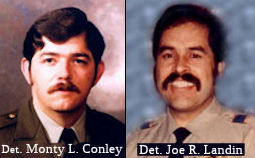 The portion of Route 198 between Road 204 and
Mehrten Drive (~ TUL T19.77 to TUL 23.761) in the County of Tulare is
officially designated as the “Detective Monty L. Conley and
Detective Joe R. Landin Memorial Highway”. It was named in
memory of Detective Monty L. Conley and Detective Joe R. Landin of the
Tulare County Sheriff's Department, who were killed on August 5, 1985,
while performing their duties on behalf of the citizens they swore to
protect. Detective Monty L. Conley was born in Shamrock, Texas. He lived
there until 1955, when he moved to Woodlake, California. He attended
Woodlake High School and the College of the Sequoias. At 19 years of age,
he became Woodlake's youngest police officer. In 1973, he joined the
Tulare County Sheriff's Department, where he worked in the jail and patrol
divisions and later as a detective in the narcotics units. Detective Joe
R. Landin was born in La Mesa, Texas, where he lived until the eighth
grade. He then moved to Woodlake, California, where he attended high
school. After joining the United States Marine Corps, and serving in
Vietnam, he returned to Woodlake in 1972 and attended the College of the
Sequoias. He became a Woodlake Police Officer in 1974. Upon joining the
Tulare County Sheriff's Department in 1981, Detective Landin worked in the
jail and patrol divisions. As a detective, he was assigned to the
Sheriff's Tactical Enforcement Patrol and the narcotics unit. On August 5,
1985, Detective Conley and his partner, Detective Landin, were
investigating a narcotics case near the town of Pixley, California, in
southern Tulare County. While the two were traveling in Detective Conley's
vehicle, they collided with another motorist who ran a stop sign at over
85 miles per hour. Both detectives lost their lives as a result of this
tragic incident. The other motorist was tried and convicted of vehicular
manslaughter with gross negligence and served a prison term of five years
and four months. Named by Assembly Concurrent Resolution 15, Resolution
Chapter 51, on July 13, 2011.
The portion of Route 198 between Road 204 and
Mehrten Drive (~ TUL T19.77 to TUL 23.761) in the County of Tulare is
officially designated as the “Detective Monty L. Conley and
Detective Joe R. Landin Memorial Highway”. It was named in
memory of Detective Monty L. Conley and Detective Joe R. Landin of the
Tulare County Sheriff's Department, who were killed on August 5, 1985,
while performing their duties on behalf of the citizens they swore to
protect. Detective Monty L. Conley was born in Shamrock, Texas. He lived
there until 1955, when he moved to Woodlake, California. He attended
Woodlake High School and the College of the Sequoias. At 19 years of age,
he became Woodlake's youngest police officer. In 1973, he joined the
Tulare County Sheriff's Department, where he worked in the jail and patrol
divisions and later as a detective in the narcotics units. Detective Joe
R. Landin was born in La Mesa, Texas, where he lived until the eighth
grade. He then moved to Woodlake, California, where he attended high
school. After joining the United States Marine Corps, and serving in
Vietnam, he returned to Woodlake in 1972 and attended the College of the
Sequoias. He became a Woodlake Police Officer in 1974. Upon joining the
Tulare County Sheriff's Department in 1981, Detective Landin worked in the
jail and patrol divisions. As a detective, he was assigned to the
Sheriff's Tactical Enforcement Patrol and the narcotics unit. On August 5,
1985, Detective Conley and his partner, Detective Landin, were
investigating a narcotics case near the town of Pixley, California, in
southern Tulare County. While the two were traveling in Detective Conley's
vehicle, they collided with another motorist who ran a stop sign at over
85 miles per hour. Both detectives lost their lives as a result of this
tragic incident. The other motorist was tried and convicted of vehicular
manslaughter with gross negligence and served a prison term of five years
and four months. Named by Assembly Concurrent Resolution 15, Resolution
Chapter 51, on July 13, 2011.
(Image source: Tulare County Fallen Officers)
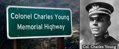 The portion of Route 198 from the postmile marker starting at Salt Creek Road (TUL
41.226, which is near Salt Creek at TUL 41.247) to the end at Sequoia
National Park (TUL 44.163) in the County of Tulare, in the County of
Tulare as the "Brigadier General
The portion of Route 198 from the postmile marker starting at Salt Creek Road (TUL
41.226, which is near Salt Creek at TUL 41.247) to the end at Sequoia
National Park (TUL 44.163) in the County of Tulare, in the County of
Tulare as the "Brigadier General Colonel
Charles Young Memorial Highway". It was named in memory of Brigadier
General Colonel Charles Young, who was born into
slavery in March 1864, in Mays Lick, Kentucky, to Gabriel Young and
Arminta Bruen. After his father, Gabriel Young, escaped from slavery and
enlisted in the Fifth Regiment of Colored Artillery, his service earned
Gabriel and his wife their freedom. Young attended the all-white high
school in Ripley, Kentucky, and graduated at the top of his class. In
1883, Charles Young took an examination for appointment as a cadet at the
United States Military Academy at West Point, and was admitted in 1884.
Having graduated from West Point in 1889 with a commission as a second
lieutenant, the third African American to do so at the time, he served
with the Ninth U.S. Cavalry Regiment for 28 years. Lieutenant Young served
as a professor for four years at Wilberforce College, where he led the new
military sciences department. When the Spanish-American War broke out,
Young was promoted to the temporary rank of Major of Volunteers on May 14,
1898, where he commanded the 9th Ohio Infantry Regiment. In
1903, Young was then appointed acting superintendent of Sequoia and
General Grant National Parks, becoming the first black superintendent of a
national park. Young, in one summer, accomplished more than the previous
three officers assigned to the park through the management of extensive
road construction, along with the improvement of the underdeveloped park,
which allowed more visitors to enjoy the park than ever before. In his
final report on the Sequoia Park to the Secretary of the Interior, Young
recommended the acquisition of privately held lands there to secure more
park area for future generations, from which legislation was introduced in
the House of Representatives. In 1904, Young married Ada Mills in Oakland,
California, and later became the father of two children, Charles Noel and
Marie Aurelia. Because of his exceptional leadership of the 10th
Cavalry, Young was promoted to Lieutenant Colonel in September 1916, the
first African American to achieve the rank of colonel in the United States
Army. Colonel Young died on January 8, 1922, from a kidney infection while
on a reconnaissance mission in Nigeria, and was given a full military
funeral at Arlington National Cemetery. Brigadier General Young was
posthumously promoted from Colonel to Brigadier General, effective
November 1, 2021. Originally Named by Assembly Concurrent Resolution (ACR)
142, Res. Chapter 143, 8/17/2018. In 2025, Senate Concurrent Resolution
(SCR) 90 (Res. Chapter 164, 09/03/25) rescinded the original designation
and changed it to “Brigadier General Charles Young Memorial
Highway”.
(Image source: 3R News; National Park Service)
The segment from Sequoia National Park (~ TUL 44.163 and beyond, although technically not maintained by the state) to Kings Canyon National Park has historically been named the "Generals Highway".
Named Structures The highway overcrossing in the City of Visalia at Plaza Drive and Route 198
(TUL R4.796) is named the “Harry Tow Memorial Highway
Overcrossing”. It was named in memory of Harry Tow, a true
Visalian. Harry attended the University of Southern California where he
studied civil engineering, earning his bachelor’s degree in 1947,
and master’s degree in 1952. Harry started as a design engineer for
the City of Los Angeles in 1948, and continued as both a city engineer and
city manager for the City of Visalia. He cofounded Quad Consulting in 1972
and worked there for 48 years, through its merger with Knopf Engineering
in 1998 to form QK. Even at the age of 94 he still worked 20 hours a week.
Harry was instrumental in overseeing the transfer of the hospital to the
Kaweah Delta Health Care District, which then set the stage for the growth
and expansion of the hospital, including the construction of the helipad
and Acequia Wing. Harry was responsible for guiding the creation of Plaza
Park and the neighboring industrial park, which laid the foundation for
what is now a thriving Industrial Park, which has created jobs and
generated revenue for the city. Harry was a role model and leader within
the community, serving as president for the Tulare County Industrial Park,
the Visalia Rotary Club, the San Joaquin Valley City Manager’s
Association, the Mt. Whitney Area Council, the Boy Scouts of America, the
California Water Environment Association, the Water Environmental
Federation, and the Kaweah Delta Hospital Foundation. He was also a member
or chair of St. Paul’s Episcopal School Board, the Diocese of Camp
San Joaquin, the League of Cities Environmental Committee, the Visalia
YMCA Board of Directors, the American Building Association, and the
College of the Sequoias Foundation Board. Harry received numerous awards
throughout his life, including the hall of fame award from the College of
the Sequoias Foundation Board, a Distinguished Award Honoree from the Boy
Scouts of America, and Man of the Year from the Visalia Chamber of
Commerce. Harry passed away on May 27, 2020, at 94 years of age. Named by
Assembly Resolution ACR 40, Res. Chapter 112, Statutes of 2021, 09/07/21.
The highway overcrossing in the City of Visalia at Plaza Drive and Route 198
(TUL R4.796) is named the “Harry Tow Memorial Highway
Overcrossing”. It was named in memory of Harry Tow, a true
Visalian. Harry attended the University of Southern California where he
studied civil engineering, earning his bachelor’s degree in 1947,
and master’s degree in 1952. Harry started as a design engineer for
the City of Los Angeles in 1948, and continued as both a city engineer and
city manager for the City of Visalia. He cofounded Quad Consulting in 1972
and worked there for 48 years, through its merger with Knopf Engineering
in 1998 to form QK. Even at the age of 94 he still worked 20 hours a week.
Harry was instrumental in overseeing the transfer of the hospital to the
Kaweah Delta Health Care District, which then set the stage for the growth
and expansion of the hospital, including the construction of the helipad
and Acequia Wing. Harry was responsible for guiding the creation of Plaza
Park and the neighboring industrial park, which laid the foundation for
what is now a thriving Industrial Park, which has created jobs and
generated revenue for the city. Harry was a role model and leader within
the community, serving as president for the Tulare County Industrial Park,
the Visalia Rotary Club, the San Joaquin Valley City Manager’s
Association, the Mt. Whitney Area Council, the Boy Scouts of America, the
California Water Environment Association, the Water Environmental
Federation, and the Kaweah Delta Hospital Foundation. He was also a member
or chair of St. Paul’s Episcopal School Board, the Diocese of Camp
San Joaquin, the League of Cities Environmental Committee, the Visalia
YMCA Board of Directors, the American Building Association, and the
College of the Sequoias Foundation Board. Harry received numerous awards
throughout his life, including the hall of fame award from the College of
the Sequoias Foundation Board, a Distinguished Award Honoree from the Boy
Scouts of America, and Man of the Year from the Visalia Chamber of
Commerce. Harry passed away on May 27, 2020, at 94 years of age. Named by
Assembly Resolution ACR 40, Res. Chapter 112, Statutes of 2021, 09/07/21.
(Image source: CWEA Website: Members in the News)
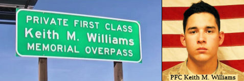 The Akers Street overpass at TUL 6.765 on Route 198 in the County of Tulare,
is named the "Private First Class Keith M. Williams Memorial Overpass".
It was named in memory of Private First Class Keith M. Williams, the
youngest of three children, born to Debbie and Frankie Williams. While
Keith was only six years old when 9/11/2001 occurred; in the years
following, he was drawn to military service by a strong sense of
patriotism and a family tradition of military service. Keith’s
father served in the United States Navy for 20 years, both his
grandfathers served in the military, and many of his other relatives
served and currently serve in various branches of the United States Armed
Forces, the New Zealand Army, and the Australian Army. Keith was a Native
American of the Yokut tribe from the Tule River, having participated in
powwows and Sweat Lodge Ceremonies. Keith was an avid skateboarder,
surfer, snowboarder, a lover of all types of music and the drums, and a
talented musician, self-taught in piano. Keith loved to sing, though he
was a terrible singer, and loved junk food, which he was known for having
at all times. During high school, Keith was a bright, easygoing young man
who participated in band, drum line, football, and link crew to assist
incoming freshman students, and was a member of the homecoming court
during his senior year. Following his graduation from El Diamante High
School in 2013, Keith chose to dedicate his life to serving his country
and enlisted in the United States Army, graduating from basic training at
Fort Benning in December 2013 from the 198th Infantry Brigade,
2-54th Infantry Battalion, Charlie Company, 4th
Platoon, Red Company Mavericks. Keith was a regular American kid who
appreciated the freedoms that were made possible by those who sacrificed
before him, and wrote on the back of his basic training picture that
freedom was not free. The proudest day of Keith’s life was the day
he marched off the field as a United States Army Infantryman, willing to
die for his battle buddies and for his country. Keith was stationed in
Fort Carson, Colorado, with the 4th Infantry Division before he
was deployed to Afghanistan in March 2014. On July 24, 2014, while on a
mission near Mirugol Kalay, Keith, an M249 SAW gunner, was the driver of
the lead vehicle and was critically wounded after his vehicle was hit by
an improvised explosive device, at which time Staff Sergeant Benjamin
Prange, who was seated next to him, died. Following the explosion, Keith
was airlifted to the Role 3 Multinational Hospital in Kandahar,
Afghanistan, where, at the age of 19, Keith died with a chaplain from his
unit holding his hand. Private First Class Keith M. Williams received
various awards and decorations for his service in the United States Army,
including the Bronze Star Medal, the Purple Heart, the Army Commendation
Medal, the Good Conduct Medal, the National Defense Service Medal, the
Afghanistan Campaign Medal with bronze service star, the Global War on
Terrorism Service Medal, the Army Service Ribbon, the Overseas Service
Ribbon, the NATO Medal, and the Combat Infantryman Badge. Private First
Class Keith M. Williams made the ultimate sacrifice while performing his
sworn duty, and it is fitting that we pay tribute to him and recall his
devotion to duty and honor his service to his country. Named by Assembly
Concurrent Resolution (ACR) 220, Res. Chapter 154, 8/17/2018.
The Akers Street overpass at TUL 6.765 on Route 198 in the County of Tulare,
is named the "Private First Class Keith M. Williams Memorial Overpass".
It was named in memory of Private First Class Keith M. Williams, the
youngest of three children, born to Debbie and Frankie Williams. While
Keith was only six years old when 9/11/2001 occurred; in the years
following, he was drawn to military service by a strong sense of
patriotism and a family tradition of military service. Keith’s
father served in the United States Navy for 20 years, both his
grandfathers served in the military, and many of his other relatives
served and currently serve in various branches of the United States Armed
Forces, the New Zealand Army, and the Australian Army. Keith was a Native
American of the Yokut tribe from the Tule River, having participated in
powwows and Sweat Lodge Ceremonies. Keith was an avid skateboarder,
surfer, snowboarder, a lover of all types of music and the drums, and a
talented musician, self-taught in piano. Keith loved to sing, though he
was a terrible singer, and loved junk food, which he was known for having
at all times. During high school, Keith was a bright, easygoing young man
who participated in band, drum line, football, and link crew to assist
incoming freshman students, and was a member of the homecoming court
during his senior year. Following his graduation from El Diamante High
School in 2013, Keith chose to dedicate his life to serving his country
and enlisted in the United States Army, graduating from basic training at
Fort Benning in December 2013 from the 198th Infantry Brigade,
2-54th Infantry Battalion, Charlie Company, 4th
Platoon, Red Company Mavericks. Keith was a regular American kid who
appreciated the freedoms that were made possible by those who sacrificed
before him, and wrote on the back of his basic training picture that
freedom was not free. The proudest day of Keith’s life was the day
he marched off the field as a United States Army Infantryman, willing to
die for his battle buddies and for his country. Keith was stationed in
Fort Carson, Colorado, with the 4th Infantry Division before he
was deployed to Afghanistan in March 2014. On July 24, 2014, while on a
mission near Mirugol Kalay, Keith, an M249 SAW gunner, was the driver of
the lead vehicle and was critically wounded after his vehicle was hit by
an improvised explosive device, at which time Staff Sergeant Benjamin
Prange, who was seated next to him, died. Following the explosion, Keith
was airlifted to the Role 3 Multinational Hospital in Kandahar,
Afghanistan, where, at the age of 19, Keith died with a chaplain from his
unit holding his hand. Private First Class Keith M. Williams received
various awards and decorations for his service in the United States Army,
including the Bronze Star Medal, the Purple Heart, the Army Commendation
Medal, the Good Conduct Medal, the National Defense Service Medal, the
Afghanistan Campaign Medal with bronze service star, the Global War on
Terrorism Service Medal, the Army Service Ribbon, the Overseas Service
Ribbon, the NATO Medal, and the Combat Infantryman Badge. Private First
Class Keith M. Williams made the ultimate sacrifice while performing his
sworn duty, and it is fitting that we pay tribute to him and recall his
devotion to duty and honor his service to his country. Named by Assembly
Concurrent Resolution (ACR) 220, Res. Chapter 154, 8/17/2018.
(Image source: YourCentralValley.Com; Me.Me)
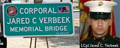 The South Giddings Avenue overcrossing of Route 198 (~ TUL R9.239) in the City of Visalia is named
the "Corporal Jared Verbeek Memorial Overcrossing" (signed as "Corporal
Jared Verbeek Memorial Bridge"). It was named in memory of Corporal
Jared Verbeek, who was born in 1989, in Visalia, California, to Travis and
Rosalia Verbeek. Corporal Verbeek's father served in the United States
Marine Corps until his retirement and his example of dedication impressed
upon his son the need to also serve his country. From an early age,
Corporal Verbeek sought the opportunity to wear a uniform in service of
his country, including joining the Boy Scouts of America and earning 13
merit badges within his first month. Always striving to do more, and be
more, than an average person, Corporal Verbeek participated in many team
sports in high school, including baseball, basketball, football, track and
field, and cross country. Corporal Verbeek maintained a high GPA in high
school while working with the Tulare County Sheriff, where he assisted in
background and training documentation, and attended Congressman Devin
Nunes' military academy at night to learn more about obtaining a
commission as a military officer. Corporal Verbeek was selected for a
congressional appointment to Annapolis Naval Academy in Annapolis,
Maryland, but instead chose to enlist with the United States Marine Corps
and went to Marine Corps recruit training in San Diego, California,
immediately after his graduation from high school. Corporal Verbeek
graduated recruit training on February 1, 2008, and was assigned as a
recruiter assistant at the Visalia recruiting substation, which pleased
Corporal Verbeek because he could stay near his family longer. Corporal
Verbeek was assigned to Marine combat training at Marine Corps Base Camp
Pendleton in Santa Margarita, California, followed by an order to Fort
Lenard Wood, Missouri, where he went through his military occupational
speciality training for military police, his chosen field. He then
received his first duty assignment with the Military Police (MP) Company
at Camp Pendleton. Corporal Verbeek volunteered to be an MP liaison for
the First Battalion of the Fifth Marine Regiment, which was deployed on
March 17, 2011, to Afghanistan. Corporal Verbeek gave the ultimate
sacrifice for our security and died on June 21, 2011, from wounds
sustained while conducting combat operations in Helmand province,
Afghanistan. Corporal Verbeek's family and friends recall his
thoughtfulness, selfless acts, laughter, brutal honesty, love for his
family, and determination to serve his country. Corporal Verbeek's service
awards include the Purple Heart, the Combat Action Ribbon, the National
Defense Service Medal, the Global War on Terrorism Service Medal, the
Marine Corps Good Conduct Medal, and the Afghanistan Campaign Medal, and a
nomination for a posthumous Purple Heart. Named by Assembly Concurrent
Resolution 129, Resolution Chapter 65, on July 5, 2012.
The South Giddings Avenue overcrossing of Route 198 (~ TUL R9.239) in the City of Visalia is named
the "Corporal Jared Verbeek Memorial Overcrossing" (signed as "Corporal
Jared Verbeek Memorial Bridge"). It was named in memory of Corporal
Jared Verbeek, who was born in 1989, in Visalia, California, to Travis and
Rosalia Verbeek. Corporal Verbeek's father served in the United States
Marine Corps until his retirement and his example of dedication impressed
upon his son the need to also serve his country. From an early age,
Corporal Verbeek sought the opportunity to wear a uniform in service of
his country, including joining the Boy Scouts of America and earning 13
merit badges within his first month. Always striving to do more, and be
more, than an average person, Corporal Verbeek participated in many team
sports in high school, including baseball, basketball, football, track and
field, and cross country. Corporal Verbeek maintained a high GPA in high
school while working with the Tulare County Sheriff, where he assisted in
background and training documentation, and attended Congressman Devin
Nunes' military academy at night to learn more about obtaining a
commission as a military officer. Corporal Verbeek was selected for a
congressional appointment to Annapolis Naval Academy in Annapolis,
Maryland, but instead chose to enlist with the United States Marine Corps
and went to Marine Corps recruit training in San Diego, California,
immediately after his graduation from high school. Corporal Verbeek
graduated recruit training on February 1, 2008, and was assigned as a
recruiter assistant at the Visalia recruiting substation, which pleased
Corporal Verbeek because he could stay near his family longer. Corporal
Verbeek was assigned to Marine combat training at Marine Corps Base Camp
Pendleton in Santa Margarita, California, followed by an order to Fort
Lenard Wood, Missouri, where he went through his military occupational
speciality training for military police, his chosen field. He then
received his first duty assignment with the Military Police (MP) Company
at Camp Pendleton. Corporal Verbeek volunteered to be an MP liaison for
the First Battalion of the Fifth Marine Regiment, which was deployed on
March 17, 2011, to Afghanistan. Corporal Verbeek gave the ultimate
sacrifice for our security and died on June 21, 2011, from wounds
sustained while conducting combat operations in Helmand province,
Afghanistan. Corporal Verbeek's family and friends recall his
thoughtfulness, selfless acts, laughter, brutal honesty, love for his
family, and determination to serve his country. Corporal Verbeek's service
awards include the Purple Heart, the Combat Action Ribbon, the National
Defense Service Medal, the Global War on Terrorism Service Medal, the
Marine Corps Good Conduct Medal, and the Afghanistan Campaign Medal, and a
nomination for a posthumous Purple Heart. Named by Assembly Concurrent
Resolution 129, Resolution Chapter 65, on July 5, 2012.
(Image source: Recorder Online; Find a Grave)
 National Trails
 This segment was part of a branch of the National Parks to Parks Trail that went to Sequoia National Park.
Scenic Route[SHC 263.8] Entire portion: Route 99 near Goshen to Sequoia Nat'l Park
Although this segment is eligible for Scenic Highway status, it has not yet met the criteria to be officially designated as Scenic Highway.
Freeway[SHC 253.7] Entire portion. Added to the Freeway and Expressway system in 1959.
 Classified Landcaped Freeway
The following segments are designated as Classified Landscaped Freeway:
| County | Route | Starting PM | Ending PM |
| Tulare | 198 | 4.22 | 5.00 |
| Tulare | 198 | 5.00 | 10.97 |
| Kings | 198 | R10.29 | R11.18 |
| Kings | 198 | R16.82 | R20.98 |
 Exit Information
 Interregional Route
[SHC 164.18] Between Route 5 and the Sequoia National Park.
StatusThe following sections of this route are constructed to freeway standards: (1) from Lemoore Naval Air Station to Ave 16 near Armona; (2) from Ave 14 to Ave 9 east of Hanford; (3) from Ave 9 to Jct 43; (4) from 1 mile W of Route 99 to Plaza Blvd (1 mi E of Route 99); (5) from Mooney Blvd (downtown Visalia) to Rd 168.
 Other WWW Links
 Statistics
Overall statistics for Route 198:
 Pre-1964 Legislative Route
In 1933, Chapter 767 defined the routes from "San Diego-Campo Road near Spring Valley to [LRN 12] near La Mesa", "[LRN 12] near El Cajon to the Descanso-Temecula Road near Santa Ysabel", and "Julian to [LRN 26] near Kane Springs" as part of the highway system. In 1935, these routes were added to the highway code as LRN 198 with the definition:
This definition remained unchanged until the 1963 renumbering. It was signed as follows:
This was originally signed as Route 67, and is now part of Route 125.
This was signed as Route 78.
© 1996-2024 Daniel P. Faigin.
Maintained by: Daniel P. Faigin
<webmaster@cahighways.org>.
 Route 197
 Route 199