
 California Highways:
Click here for a key to the symbols used. An explanation of acronyms may be found at the bottom of the page.
 Routing
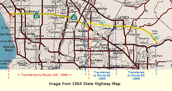 No current routing.
 Post 1964 Signage History
 In 1963, this route was defined as "Route 1 west of Inglewood to
Route 91 in Santa Ana Canyon via the vicinity of Norwalk."
On June 5,1963, a public hearing was held regarding the Century Freeway (then Route 42) from the Pacific Coast Freeway (Route 1) to the Santa Ana Freeway (I-5).
In 1965, the portion of former Route 42 from Route 605 to Route 39 was transferred to Route 90, and the routing was redefined as (1) from Route 1 west of Inglewood to Route 605 and (2) Route 39 near La Habra to Route 91 in Santa Ana Canyon. A 1965 planning map shows this as freeway from Route 405 to Route 605, and then continuing as freeway from Route 605 to Route 91 along what is now Route 90.
In 1966, the state highway map shows the surface routing along Manchester and Firestone, but a proposed freeway routing along the future I-105 (Century Freeway) route.
In 1968, part (1) was transferred to Route 105, and part (2) was transferred to Route 90. Part (1) became the "Century Freeway", and part (2) became the "Yorba Linda Freeway". This resulted in the route's deletion.
Note: See the page on I-105 for information on freeway route adoptions.
 Pre 1964 Signage History
 Before this route was designated as Route 42, it was signed as Route 10. In 1961, the route was resigned as Route 42. The pre-1964 routing ran
only between US 101A (now Route 1) and US 101 (now Route 5). It appears
that Route 42 was originally LRN 174 (defined in 1933) between Route 1 and
Route 19. LRN 176, defined in 1933 between Route 39 and Route 91, and
extended to Route 19 in 1959. As part of Route 10, portions were signed as
Bypass US 101.
Before this route was designated as Route 42, it was signed as Route 10. In 1961, the route was resigned as Route 42. The pre-1964 routing ran
only between US 101A (now Route 1) and US 101 (now Route 5). It appears
that Route 42 was originally LRN 174 (defined in 1933) between Route 1 and
Route 19. LRN 176, defined in 1933 between Route 39 and Route 91, and
extended to Route 19 in 1959. As part of Route 10, portions were signed as
Bypass US 101.
 In 1934, Route 10 was signed along the
routing from Jct. Route 3 (US 101A, later Route 1) south of Venice to Jct.
US 101 at Santa Ana, via Manchester Avenue and Santa Ana Blvd. This
routing was LRN 174 from US 101A (Route 1, Lincoln Blvd) in Los Angeles
along Manchester and Firestone Blvds to US 101 in Norwalk. In 1961, the
routing was resigned as Route 42in preparation for the interstate. (1956
and 1960 maps shows it as Route 10; the 1963 state map (pre-renumbering)
shows it as Route 42). Before signage as US-101, the routing (signed as
Route 10, but LRN 174) continued on down to Orangethorpe, and then across
Orangethorpe past Route 101 (Spadra Road, at that time) and E through
Atwood, until joining the old surface route equivalent to US 101 (LRN 2).
Some maps show Route 10 ending at the junction with Route 18 (later
renumbered as Route 14, but cosigned with US 91; LRN 175 and LRN 178). It
appears that, by 1942, Route 10 was also signed as Bypass US 101.
In 1934, Route 10 was signed along the
routing from Jct. Route 3 (US 101A, later Route 1) south of Venice to Jct.
US 101 at Santa Ana, via Manchester Avenue and Santa Ana Blvd. This
routing was LRN 174 from US 101A (Route 1, Lincoln Blvd) in Los Angeles
along Manchester and Firestone Blvds to US 101 in Norwalk. In 1961, the
routing was resigned as Route 42in preparation for the interstate. (1956
and 1960 maps shows it as Route 10; the 1963 state map (pre-renumbering)
shows it as Route 42). Before signage as US-101, the routing (signed as
Route 10, but LRN 174) continued on down to Orangethorpe, and then across
Orangethorpe past Route 101 (Spadra Road, at that time) and E through
Atwood, until joining the old surface route equivalent to US 101 (LRN 2).
Some maps show Route 10 ending at the junction with Route 18 (later
renumbered as Route 14, but cosigned with US 91; LRN 175 and LRN 178). It
appears that, by 1942, Route 10 was also signed as Bypass US 101.
On August 21, 1933, it was reported that Firestone Boulevard, sometimes
known as Manchester Avenue, was widened from 40 feet to 74 feet and became
part of the California state highway system. The article noted that the
road will be one of the principal traffic arteries connecting the Coast
Highway, the southerly portion of Los Angeles, and contiguous territory
with Anaheim, Orange, and Santa Ana.
(Source: This Date in Los Angeles Transportation History, August 21)
When Route 10 (LRN 174) was first signed, it followed the general course
of the Southern Pacific Railroad from Firestone Boulevard to the Orange
County Line over numerous at-grade crossings. In Orange County, it
followed Grand Avenue and Lincoln Avenue from Buena Park to downtown
Anaheim. From downtown Anaheim, Route 10 followed Los Angeles Street
and southern Manchester Boulevard towards Santa Ana.
(Source: Gribblenation Blog (Tom Fearer), "Former California State Route 42 and Former California State Route 10", December 2021)
 On April 30, 1937, the last section of Manchester Blvd in
Anaheim was dedicated for public use. CHPW described the route as
“This route extends easterly from [LRN 60, Route 1] in Los Angeles
County at Playa del Rey, through the cities of Inglewood, Los Angeles and
South Gate, thence southeasterly in a direct line through the communities
of Downey, Norwalk and Buena Park, and through the southwesterly corner of
the city of Anaheim, connecting with [LRN 2, US 101] in Orange County at
Miraflores, and makes a total distance of 33.01 miles”. The
accompanying map shows the last sections being between Market and
Hillcrest in Inglewood (1935), Compton to Santa Fe (1934), and a large
section from perhaps near Downey Ave to near Anaheim Blvd (then, Los
Angeles Avenue, US 101) and Katella (1935-1937). This replaced an old
routing that ran from Firestone to Woodruff to Imperial Hwy to Studebaker
to Foster to Norwalk to Rosecrans to Stage Road to Grand/Stanton (Route 39, now Beach Blvd) to Lincoln Ave to Anaheim (routing is approximate,
attempting to track an old map). The CHPW articles notes “The plan
to project this Manchester Avenue route from the Roosevelt Highway (US 101A), near Playa del Rey, to connect with Coast Highway [LRN] 2 (US 101),
near Santa Ana, became a unified program of the State in 1933. when this
proposed route became a part of the State Highway System as [LRN 174]. At
that time portions of the road had been laid as city streets, but with no
connecting links. Then the only portion of this road improved to full
width pavement was 5.9 miles within the cit.y of Los Angeles. Since
January 9, 1934, when construction was started by the State on the first
contract, work has progressed steadily. With the cooperation of the cities
and counties, rights of way have been secured, widening and new
construction completed on 27.1 miles of highway, the completed roadway
pavement surface varying in widths from thirty feet to seventy-six
feet.” The map above is hard to follow as roads have changed names.
Cerritos Ave appears to have been renamed Lakewood Blvd, making Sumerset
closer to Bellflower. The split in Buena Park appears to be where Stage
(veering to the left) splits from Beach (note that Beach was previously
Grand and Stanton)
On April 30, 1937, the last section of Manchester Blvd in
Anaheim was dedicated for public use. CHPW described the route as
“This route extends easterly from [LRN 60, Route 1] in Los Angeles
County at Playa del Rey, through the cities of Inglewood, Los Angeles and
South Gate, thence southeasterly in a direct line through the communities
of Downey, Norwalk and Buena Park, and through the southwesterly corner of
the city of Anaheim, connecting with [LRN 2, US 101] in Orange County at
Miraflores, and makes a total distance of 33.01 miles”. The
accompanying map shows the last sections being between Market and
Hillcrest in Inglewood (1935), Compton to Santa Fe (1934), and a large
section from perhaps near Downey Ave to near Anaheim Blvd (then, Los
Angeles Avenue, US 101) and Katella (1935-1937). This replaced an old
routing that ran from Firestone to Woodruff to Imperial Hwy to Studebaker
to Foster to Norwalk to Rosecrans to Stage Road to Grand/Stanton (Route 39, now Beach Blvd) to Lincoln Ave to Anaheim (routing is approximate,
attempting to track an old map). The CHPW articles notes “The plan
to project this Manchester Avenue route from the Roosevelt Highway (US 101A), near Playa del Rey, to connect with Coast Highway [LRN] 2 (US 101),
near Santa Ana, became a unified program of the State in 1933. when this
proposed route became a part of the State Highway System as [LRN 174]. At
that time portions of the road had been laid as city streets, but with no
connecting links. Then the only portion of this road improved to full
width pavement was 5.9 miles within the cit.y of Los Angeles. Since
January 9, 1934, when construction was started by the State on the first
contract, work has progressed steadily. With the cooperation of the cities
and counties, rights of way have been secured, widening and new
construction completed on 27.1 miles of highway, the completed roadway
pavement surface varying in widths from thirty feet to seventy-six
feet.” The map above is hard to follow as roads have changed names.
Cerritos Ave appears to have been renamed Lakewood Blvd, making Sumerset
closer to Bellflower. The split in Buena Park appears to be where Stage
(veering to the left) splits from Beach (note that Beach was previously
Grand and Stanton)
(Source: This Date in Los Angeles Transportation History, April 30)
The April 30th, 1937 "Manchester Boulevard Extension" provided a direct
link between Downey and Anaheim that followed the Southern Pacific
Railroad. The Manchester Boulevard Extension bypassed downtown
Anaheim and tied into existing alignment of Route 10 (LRN 174) on southern
Manchester Boulevard at Miraflores near the outskirts of Santa Ana.
The Manchester Boulevard Extension was originally conceptualized during
1924 by the Greater Manchester Avenue Improvement Association. The
Manchester Boulevard Extension concept was taken over by the Division of
Highways when LRN 174 was added as a State Highway circa 1933. By
1940, US 101 Bypass was co-signed with Route 10/LRN 174 from Route 19/LRN 168 on Rosemead Boulevard in Downey to US 101/LRN 2 in Santa Ana.
The specific creation date of US 101 Bypass is unknown as it does not
appear in the accessible AASHTO Database. US 101 Bypass departed US Route 101/LRN 2 in Los Angeles via LRN 166/Indian Street and LRN 166/Anaheim-Telegraph Road to Route 19/Rosemead Boulevard. By 1942,
Route 10 was truncated to an eastern terminus at US 101 Bypass/Route 19 at
Rosemead Boulevard in Downey.
(Source: Gribblenation Blog (Tom Fearer), "Former California State Route 42 and Former California State Route 10", December 2021)
In 1950, work was in progress to convert the US 101 Alternate (formerly
Bypass) on LRN 174/Manchester Boulevard Extension into a segment of the
Santa Ana Freeway. The construction zone began at Rosecrans Avenue
11.4 miles southeast to Miraflores near Santa Ana. The work was
divided into three project zones. By 1952, the Santa Ana Freeway was
either contracted or completed from downtown Los Angeles to Route 19/Rosemead Boulevard and from the southern outskirts of Norwalk southeast
via LRN 174 to Los Angeles Street in Anaheim. The Santa Ana Freeway
was anticipated to be completed between the Los Angeles Civic Center and
Route 19/Rosemead Boulevard by late 1952/early 1953. By 1954, the
Santa Ana Freeway via LRN 166 extended from Anaheim-Telegraph Road
designated as mainline US 101. US 101 bypassed downtown Norwalk,
connecting with the existing Santa Ana Freeway project zone on Firestone
Boulevard/LRN 174. The interim alignment of US 101 entered Norwalk
via Pioneer Boulevard southward to Firestone Boulevard/LRN 174.
Route 10 was extended easterly on Firestone Boulevard/LRN 174 from Route 19/Rosemead Boulevard to meet the new alignment US 101. By 1955,
Route 10 was extended through downtown Norwalk via Firestone Boulevard,
Bloomfield Avenue and Rosecrans Boulevard to US 101/Santa Ana
Freeway. In 1960, Route 10 was renumbered to Route 42 to avoid
duplication with the new I-10. Route 42 first appears on the 1961
Division of Highways Map.
(Source: Gribblenation Blog (Tom Fearer), "Former California State Route 42 and Former California State Route 10", December 2021)
On July 1, 1964, LRN 174 (at one time signed as Route 10), between
US 101A and US 101 in Norwalk, was officially designated Route 42, and has
since been deleted from the state highway system.
Route 42 was not assigned as part of the 1934 signage of state
routes. It is unclear if any route was signed as Route 42 between 1934 and
the resignage of Route 10 as Route 42 in 1961.
 US 42 was the original number proposed in 1926 for what was later US 48, which was later renumbered as part of US 50. This is now part of Route 37.
 Status
The CalTrans bridge log indicates that Route 105 is signed in its entirety as Route 42. What this means is that the currently signed Route 42 is really the old traversable routing of Route 105. In mid-2000, CalTrans finally relinquished all portions of Route 42, although it still has some of the old signs in some places. The CalTrans photolog still shows some portions of Route 42 as unrelinquished in 2001.
The SAFETEA-LU act, enacted in August 2005 as the reauthorization of TEA-21, provided the following expenditures on or near this route:
 Other WWW Links
 Pre-1964 Legislative Route
The route that became LRN 42 was first defined in 1913 by Chapter 398, which called for "the survey and construction of a state highway from the point known as Saratoga Gap on the line between the counties of Santa Clara and Santa Cruz, extending thence by the practicable route in a generally SW-ly direction along the ridge between the San Lorenzo and Pescadero creeks to the present boundary of the California State Redwoods Park, thence into the California State Redwoods Park in Santa Cruz County to Governor's Camp, and thence through said park to the boundary thereof at Bloom's Mill."
In 1933, the route was extended from [LRN 55] near Saratoga Gap to [LRN 5] near Los Gatos. It was codified into the highway code in 1935 as follows:
[LRN 5] near Los Gatos to Governor's Camp in California Redwood Park via Saratoga Gap and along the ridge between San Lorenzo and Pescadero Creeks.
This definition remained until the 1963 renumbering. The route is the present-day Route 236 between Governor's Camp near Big Basin and the Route 9/Route 269 junction, and then Route 9 to Route 17 (former LRN 5). The California Redwood State Park Road ("from Saratoga Gap, on the line between the counties of Santa Clara and Santa Cruz, to, into and within California Redwood Park...") was defined in 1913. The remainder of the route (to Route 17 near Los Gatos) was defined in 1933. The Route 9 signage dates back to 1934.
© 1996-2020 Daniel P. Faigin.
Maintained by: Daniel P. Faigin
<webmaster@cahighways.org>.
 Route 41
 Route 43