
 California Highways:
Click here for a key to the symbols used. An explanation of acronyms may be found at the bottom of the page.
 Routing
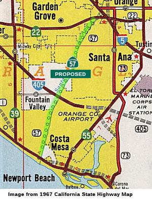 ▸From Route 1 near Huntington Beach to Route 22 near
Santa Ana.
▸From Route 1 near Huntington Beach to Route 22 near
Santa Ana.
 Post 1964 Signage History
This segment is as defined in 1963.
 Pre 1964 Signage History
This route was proposed, but unconstructed before 1964. It was LRN 273. This route was defined in 1959.
 Status
 This segment is unconstructed between Route 1 and I-405. There
is no traversable highway identified.
This segment is unconstructed between Route 1 and I-405. There
is no traversable highway identified.
The 2013 Traversable Highways report notes that no improvement are planned to extend Route 57 from I-5/Route 22/Route 57 to I-405/Route 73/Route 1.
In 1969, the Division of Highways began studies to determine the routing
of the final 10.7 mi segment of the Orange Freeway (Route 57). This
segment would run generally N/S between the Pacific Coast Freeway (Route 1) and the junction of I-5 and Route 22. Final route adoption was
scheduled for 1973.
(Source: Los Angeles Times, 4/1/1969 via Joel Windmiller, 2/23/2023)
 Between I-405 and I-5, this segment was at one time
planned for pilot toll road project. It would have been a 4-lane, 11.2
mile extension located within the Santa Ana Flood Control Channel
right-of-way. Recently, the Orange County Transportation Authority voted
its support for the toll road portion of Route 57. However, on 1/3/2001, a
Caltrans spokesman announced that it is "very unlikely" that the
department would extend a 10-year-old toll franchise agreement for the
proposed SR-57 Extension project. However, the OCTA revisited the idea in
early 2003. Supervisor Chris Norby, who sits on the OCTA board of
directors, wants to fast-track a $1.1-million study to determine whether
the 57 Extension is practical from engineering and political standpoints.
Between I-405 and I-5, this segment was at one time
planned for pilot toll road project. It would have been a 4-lane, 11.2
mile extension located within the Santa Ana Flood Control Channel
right-of-way. Recently, the Orange County Transportation Authority voted
its support for the toll road portion of Route 57. However, on 1/3/2001, a
Caltrans spokesman announced that it is "very unlikely" that the
department would extend a 10-year-old toll franchise agreement for the
proposed SR-57 Extension project. However, the OCTA revisited the idea in
early 2003. Supervisor Chris Norby, who sits on the OCTA board of
directors, wants to fast-track a $1.1-million study to determine whether
the 57 Extension is practical from engineering and political standpoints.
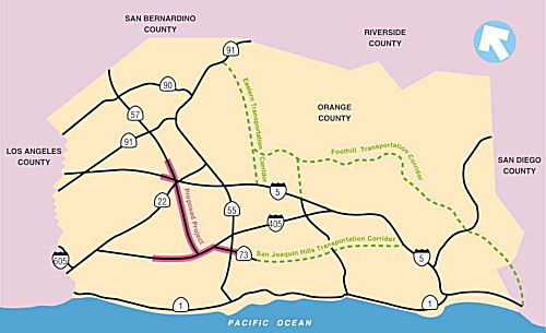 According to the Los Angeles
Times in November 2005, Orange County transportation officials recently
voted to extend Route 57 southwest along the Santa Ana River to I-405.
With this vote, the OCTA board voted to hire a consultant to prepare a
three-month feasibility study for a double-deck freeway above the river.
The proposal still faces likely opposition from the Army Corps of
Engineers, neighborhoods and proponents of a park along the river.
Extending the freeway down the Santa Ana River would take commuters 6.5
miles through Santa Ana and Fountain Valley. An extension has been
discussed for years. But past proposals focused on routing a six-lane
freeway through neighborhoods and shopping centers in Santa Ana. Plans to
build an extension above the river, instead, materialized about the same
time, in 1986. One proposal called for building piers thrust into the
Santa Ana River to serve as pillars for the freeway. There also has been
talk about building the extension as a tollway, connecting it to the San
Joaquin Hills tollway in Costa Mesa. Any proposal involving a route above
the river will involve the Army Corps of Engineers, which has major
flood-control jurisdiction over the river. According to a corps spokesman
in Los Angeles, any plan for a freeway above a flood control channel has
an uphill battle, due to impacts on the flood channel. In October 2007,
the study reported its result. The study showed that the proposed
eight-mile route above the Santa Ana River connecting to the San Diego
Freeway would cost about $2 billion. The study identified no funding for
the route, and the extension was not included among projects under Measure
M, a half-cent local sales tax for transportation improvements. It also
found that using a route for the extension down the river is possible but
there are other challenges, such as the impacts to the environment and the
neighboring communities. Santa Ana officials feel that the transportation
benefits would be outweighed by the negative environmental impacts effects
and reduced the quality of life for city residents.
According to the Los Angeles
Times in November 2005, Orange County transportation officials recently
voted to extend Route 57 southwest along the Santa Ana River to I-405.
With this vote, the OCTA board voted to hire a consultant to prepare a
three-month feasibility study for a double-deck freeway above the river.
The proposal still faces likely opposition from the Army Corps of
Engineers, neighborhoods and proponents of a park along the river.
Extending the freeway down the Santa Ana River would take commuters 6.5
miles through Santa Ana and Fountain Valley. An extension has been
discussed for years. But past proposals focused on routing a six-lane
freeway through neighborhoods and shopping centers in Santa Ana. Plans to
build an extension above the river, instead, materialized about the same
time, in 1986. One proposal called for building piers thrust into the
Santa Ana River to serve as pillars for the freeway. There also has been
talk about building the extension as a tollway, connecting it to the San
Joaquin Hills tollway in Costa Mesa. Any proposal involving a route above
the river will involve the Army Corps of Engineers, which has major
flood-control jurisdiction over the river. According to a corps spokesman
in Los Angeles, any plan for a freeway above a flood control channel has
an uphill battle, due to impacts on the flood channel. In October 2007,
the study reported its result. The study showed that the proposed
eight-mile route above the Santa Ana River connecting to the San Diego
Freeway would cost about $2 billion. The study identified no funding for
the route, and the extension was not included among projects under Measure
M, a half-cent local sales tax for transportation improvements. It also
found that using a route for the extension down the river is possible but
there are other challenges, such as the impacts to the environment and the
neighboring communities. Santa Ana officials feel that the transportation
benefits would be outweighed by the negative environmental impacts effects
and reduced the quality of life for city residents.
According to the Caltrans Page on the Route 57 Toll Road, "As proposed, this $950 million project is a 4-lane, 11.2 mile extension of Route 57 from Route 5 to Route 405 located within the Santa Ana River Flood Control Channel right-of-way. The four lanes would consist of 2 two-lane viaducts running longitudinally down the river channel. The franchisee is American Transportation Development (ATD), a partnership of Interwest Company, Inc. and Washington Group, International, Inc. ATD has requested that the required date for commencement of construction be extended from January 11, 2001 to January 11, 2007. This request was denied and the franchise was terminated in January, 2001. ATD contested the termination and it had been in litigation until it was resolved on November 14, 2003."
 Naming
This segment is named the "Orange Freeway". It was named by Assembly Concurrent Resolution No. 17, Chapter 157, in 1969. It was named because it traverses the community of Orange, CA, which was founded in 1873 (the county was created in 1889). The city was probably named to advertise one of the principal products of the district, although it may also have been named after one of the fifty-odd other Oranges in the U.S.
The South Street overcrossing is named the "Jim Dowling Memorial Bridge". This is an unofficial name, as Caltrans signed it before the Assembly Bill passed, and the bill was then dropped. It was named in memory of Jim Downing, a victim of a drunk limousine driver around 1984 at the age of 26. It is unclear where this is on the proposed routing.
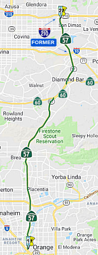 ▸From Route 5 near Santa Ana to Route 210 near San
Dimas.
▸From Route 5 near Santa Ana to Route 210 near San
Dimas.
As of November 24, 2002, the portion from I-10 to I-210/Route 210 was signed as Route 57. Previously, this segment had been signed as part of I-210.
Post 1964 Signage History▸In 1963, this segment was defined as the segment "Route 5 near Santa Ana to Route 210 near Route 10 and Pomona, passing near Industry." Note that the Route 210 referred to in this segment is the former I-10/I-210 junction in Pomona, not the current I-210/Route 57 junction in San Dimas.
▸In 1965, Section 1371 split this into two segments: "(b) Route 5 near Santa Ana to Route 60 near Industry. (c) Route 60 near Industry to Route 210 near Route 10 and Pomona."
In 1969, it was reported that two projects on this route were nearing
completion: 4 mi from the Riverside Freeway to Nutwood Ave, 2.3 mi from
Nutwood to Imperial Highway. Another project ran 6.9 mi from Imperial
Highway to the Route 60 freeway through Brea Canyon.
(Source: Los Angeles Times, 4/1/1969 via Joel Windmiller, 2/23/2023)
▸In 1998, AB 2388 (Chapter 221) recombined these segments, and renumbered former Route 210 between the I-10 (near Pomona) to the I-210/Former Route 30 jct (near San Dimas) portion as Route 57, creating the current definition. However, in terms of postmiles, the portion of the route that runs along Route 60 is not part of Route 57.
Gribblenation Blog (Tom Fearer), "California State Route 57", 8/12/2023 provides the details of when particular freeway segments were completed.
Pre 1964 Signage HistoryIn 1931, the first portion of future Route 57 was defined. This portion was an extension of LRN 19, running from LRN 2 near Fullerton to Pomona. LRN 2 at the time was along Whittier Blvd and Spadra (later renamed Harbor Blvd). This portion of Route 57 ran along Brea Blvd/Brea Canyon Road from Harbor Blvd to the eventual US 60. (LRN 19 then continued along the US 60 routing to Pomona).
LRN 19 between Pomona and Fullerton was completed and opened to traffic
on July 15, 1933. It was not assigned a Sign Route. By 1935, LRN 19
branched away from US 101/LRN 2 in Fullerton via Pomona Avenue (now Brea
Boulevard) and Spadra Road (now Brea Canyon Road). Upon entering Los
Angeles County, LRN 19 emerged from the Orange County line along Brea
Canyon Road, following Brea Canyon Road and 5th Street into downtown
Pomona where it intersected US 60 at Garey Avenue.
(Source: Gribblenation Blog (Tom Fearer), "California State Route 57", 8/12/2023)
By 1955, discussions regarding a Brea Canyon Freeway had begun. In 1956,
the California Highway Commission selected an alignment for the US 101-LRN 19 Freeway (alternatively the Brea Canyon Freeway). By 1960, an agreement
was in place to construct the Brea Canyon Freeway. The Brea Canyon Freeway
was planned to pass through the cities of Orange, Santa Ana, Placentia,
Anaheim, Fullerton and Brea. In 1962, California Highways & Public
Works announced the contract to construct the Route 22/Garden Grove
Freeway, I-5/US 101/Santa Ana Freeway and the Orange Freeway Interchange
(formerly the Brea Canyon Freeway).
(Source: Gribblenation Blog (Tom Fearer), "California State Route 57", 8/12/2023)
In 1959, other portions of Route 57 were defined. The portion between Route 60 and I-10 was part of LRN 272 with an indeterminate routing. The portion between I-10 and I-210 was originally part of Route 71, and was LRN 240. This portion later became part of I-210, and was renumbered as part of Route 57 in 1998.
 in Pomona") In 1963, California Highways & Public Works announced 8.7 miles of
I-210/LRN 240 and LRN 272 in the cities of Pomona, San Dimas and Glendora
had been selected for adoption during the last four California Highway
Commission meetings of 1962. Also in 1963, it was announced that the
entire Orange Freeway would be signed as Route 57. The Santa Ana
Freeway-San Bernardino Freeway portion of the Orange Freeway had 19.8
miles adopted by the California Highway Commission. The segment of
the Orange Freeway on LRN 273 to Huntington Beach had not yet been
adopted.
In 1963, California Highways & Public Works announced 8.7 miles of
I-210/LRN 240 and LRN 272 in the cities of Pomona, San Dimas and Glendora
had been selected for adoption during the last four California Highway
Commission meetings of 1962. Also in 1963, it was announced that the
entire Orange Freeway would be signed as Route 57. The Santa Ana
Freeway-San Bernardino Freeway portion of the Orange Freeway had 19.8
miles adopted by the California Highway Commission. The segment of
the Orange Freeway on LRN 273 to Huntington Beach had not yet been
adopted.
(Source: Gribblenation Blog (Tom Fearer), "California State Route 57", 8/12/2023)
The portion between former LRN 2 and present-day I-5, was not part of the pre-1964 state highway system. The specific freeway routing also appears to be post-1964. The portion of this route between Route 5 and Route 91 (LRN 43) is similar to what was LRN 180; however, LRN 180 is the same routing as 1964-1981 Route 250. LRN 180 was defined in 1933. However, a 1959 Renie Atlas from the Division of Highways shows an approximate routing for what would become Route 75, penciled in for some reason as LRN 2, running between Placentia (State College) and Rio Vista from I-5 to LRN 19 near Deodara (now Lambert) at about where State College is today. At that point, it met the penciled in routing for LRN 19 and continued up to Brea Canyon.
 In 1962, route proposals were being presented for the portion of future Route 57 between Route 60 (the Pomona Freeway) and the Foothill Freeway (Route 210/Route 30). These also included the connection to Route 71. The routes
shown are not exact routings but the general routings to explore.
In 1962, route proposals were being presented for the portion of future Route 57 between Route 60 (the Pomona Freeway) and the Foothill Freeway (Route 210/Route 30). These also included the connection to Route 71. The routes
shown are not exact routings but the general routings to explore.
(Source: Progress-Bulletin, 7/4/1962 via Joel Windmiller, 2/19/2023)
It has been opined (still to be confirmed) that changes in the budgets
led to combinations with other construction underway. This, combined with
opposition from cities with projects underway, and the need to avoid
existing obstacles such as cemeteries, led to the selection of the eastern
route that ran concurrent with Route 60.
(Source: Musings by Edward Weiss on FB, Freeways of Los Angeles, 2/23/2023)
Sign Route 57 was not part of the initial set of state signed routes in 1934. It is unclear when Route 57 was first signed.
StatusSR-57 Improvement Project (ORA 11.5/12.5)
![]() InJune
2017, it was reported that OCTA, in partnership with Caltrans, is in the
initial phase of evaluating the potential benefits and effects of
extending the fifth general-purpose lane of northbound Route 57 from
Orangewood Ave to Katella Avenue (~ ORA 11.779 to ORA 12.532). The project
area is about a mile long and is located between Orangewood Avenue in
Orange and Katella Avenue in Anaheim. The project is part of Measure M,
the half-cent sales tax approved by voters for transportation improvements
in Orange County. This initial stage of the project will study the
benefits and potential environmental impacts of increasing capacity on the
Route 57 by extending the fifth general-purpose lane to this portion of
the freeway. The project’s draft environmental document is
anticipated to circulate for public review and comment in mid-2018, and
the environmental study phase is expected to be completed in late 2018.
InJune
2017, it was reported that OCTA, in partnership with Caltrans, is in the
initial phase of evaluating the potential benefits and effects of
extending the fifth general-purpose lane of northbound Route 57 from
Orangewood Ave to Katella Avenue (~ ORA 11.779 to ORA 12.532). The project
area is about a mile long and is located between Orangewood Avenue in
Orange and Katella Avenue in Anaheim. The project is part of Measure M,
the half-cent sales tax approved by voters for transportation improvements
in Orange County. This initial stage of the project will study the
benefits and potential environmental impacts of increasing capacity on the
Route 57 by extending the fifth general-purpose lane to this portion of
the freeway. The project’s draft environmental document is
anticipated to circulate for public review and comment in mid-2018, and
the environmental study phase is expected to be completed in late 2018.
(Source: OCTA Blog, 6/20/2017)
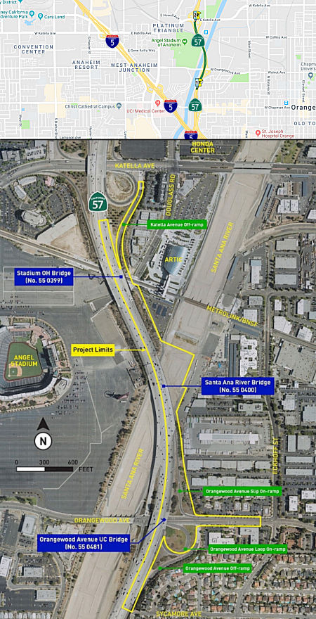 In October 2018, the Draft EIR for the project was made available for review.
The project (a joint project of Caltrans and the Orange County
Transportation Authority (OCTA)), proposes to widen the northbound side of
Route 57 from 0.3 mile south of the Orangewood Avenue undercrossing (ORA
11.5) north to the Katella Avenue undercrossing (ORA 12.5), a distance of
approximately one mile. The project includes the construction of a
550-foot section of the fifth general purpose (GP) lane in the northbound
direction of Route 57 through the Katella Avenue interchange, upgrades to
the non-standard median and sight distances, and reconfiguration of the
existing on- and off-ramps to improve operation between the Orangewood
Avenue interchange and the Katella Avenue interchange. Caltrans is the
lead agency under the National Environmental Policy Act (NEPA) and the
California Environmental Quality Act (CEQA).
In October 2018, the Draft EIR for the project was made available for review.
The project (a joint project of Caltrans and the Orange County
Transportation Authority (OCTA)), proposes to widen the northbound side of
Route 57 from 0.3 mile south of the Orangewood Avenue undercrossing (ORA
11.5) north to the Katella Avenue undercrossing (ORA 12.5), a distance of
approximately one mile. The project includes the construction of a
550-foot section of the fifth general purpose (GP) lane in the northbound
direction of Route 57 through the Katella Avenue interchange, upgrades to
the non-standard median and sight distances, and reconfiguration of the
existing on- and off-ramps to improve operation between the Orangewood
Avenue interchange and the Katella Avenue interchange. Caltrans is the
lead agency under the National Environmental Policy Act (NEPA) and the
California Environmental Quality Act (CEQA).
(Source for this, and the details below: OCTA Blog, 10/17/2018; District 12 Project DEA Page; State Route 57 Northbound Improvement Project: Orange County, California - District 12 – ORA-57 (PM 11.5 – 12.5) - 1213000099/EA 0M9700 - Initial Study [with Proposed] Mitigated Negative Declaration/Environmental Assessment, October 2018, Chapter 1: Proposed Project)
The 0.75-mile segment from the Orangewood Avenue interchange to the Katella Avenue off-ramp currently has an inside HOV lane, four to five GP lanes, and one auxiliary lane. The auxiliary lane merges with the fifth GP lane located between the Orangewood Avenue loop on-ramp and the Katella Avenue off-ramp. The merge results in a gap of 0.75 mile on the mainline with only four GP lanes between where the fifth GP lane merges with the auxiliary lane north of the Orangewood Avenue loop on-ramp and where the fifth GP lane resumes north of the Katella Avenue off-ramp. The loss of both the auxiliary lane and the fifth GP lane within the 0.75-mile mainline segment results in excessive lane changes and congestion. The proposed Project addresses this existing gap in the fifth lane, as well as several nonstandard design issues representing the most critical features adversely affecting mainline operations in this segment of the freeway (Orangewood Avenue to Katella Avenue). Route 57 is currently congested during peak periods, and the future northbound Route 57 mainline between the Orangewood Avenue and Katella Avenue interchanges is forecast to lack sufficient capacity, which will result in poor mobility. Further, several existing nonstandard design features, including weaving and merging issues, adversely affect freeway operations.
A total of four alternatives are evaluated in detail for the proposed Project. Three Build Alternatives and the No Build Alternative. The three Build Alternatives include Alternative 2, Alternative 2A, and Alternative 2B. The latter two Build Alternatives originated as options to Alternative 2, but are sufficiently different that they are evaluated as full alternatives. Alternative 1 is the No Build Alternative. The three build alternatives include the following features (although with other factors not relevant for the site):
The build alternative unique features are:
Project costs (includes construction and capital R/W costs only) for the Build Alternatives have been estimated ranging from approximately $38 to $43 million for current cost and $49 to $55 million for escalated cost. Construction is anticipated to last 24 months; beginning in July 2023 and concluding in June 2025. After public circulation of the draft environmental document, all comments will be considered, and a preferred alternative will be selected and a final determination of the Project’s effect on the environment will be made. Alternatives considered but discarded included:
In June 2019, the CTC approved for future consideration
of funding a project located on Route 57 from Orangewood Avenue to Katella
Avenue in Orange County (12-Ora-57, PM 11.5/12.5). The project proposes to
construct a fifth general purpose lane in the northbound direction of
Route 57 through the Katella Avenue interchange. Also proposed are
upgrades to non-standard median and sight distances, and reconfiguration
of existing on and off ramps which will relieve existing northbound Route 57 congestion and improve mobility by adding capacity. The project is
currently funded through the Project Approval/Environmental Document phase
from Surface Transportation Block Grant funds. Additional funding may
potentially come from Federal, State and local sources. Construction is
projected to begin in fiscal year 2022-23.
(Source: June 2019 CTC Minutes, Agenda Item
2.2c.(1))
In March 2021, it was reported that OCTA, in
partnership with Caltrans, was moving forward on a project to improve
northbound Route 57. The Route 57 Northbound Improvement Project will
extend a fifth regular freeway lane along a 1-mile stretch of the
northbound freeway between Orangewood and Katella avenues, at the border
of Anaheim and Orange. One of the unique engineering challenges of the
project is widening the ramp above the existing rail tracks used by
Metrolink and Pacific Surfliner trains. Plans call for making the
improvements while not affecting rail traffic. The project, estimated to
cost approximately $50 million, is scheduled to break ground in 2025 and
be completed in 2027.
(Source: OCTA Blog, 3/19/2021)
Katella to Lincoln Avenue (~ ORA 12.532 to ORA 14.805)
![[Project Map]](maps/057-anaheim.jpg) Improvements to this segment are planned through the 2007 Corridor Improvement Mobility
Account allocations. Specifically, $70 million was approved to widen the
route NB from Route 91 to Lambert Rd., and just over $20 million to widen
the route NB from Katella Ave to Lincoln Ave. However, $36 million to add
a NB lane from Lambert Rd. to L.A. Cty. line was not recommended.
Improvements to this segment are planned through the 2007 Corridor Improvement Mobility
Account allocations. Specifically, $70 million was approved to widen the
route NB from Route 91 to Lambert Rd., and just over $20 million to widen
the route NB from Katella Ave to Lincoln Ave. However, $36 million to add
a NB lane from Lambert Rd. to L.A. Cty. line was not recommended.
In July 2009, the CTC approved the transfer of deleted CMIA funding for Route 91 to Route 57 projects: specificially, they transferred $14,606,000 CMIA to the widen northbound Route 57 from 0.3 mile south of Katella Avenue to 0.3 mile north of Lincoln Avenue project (PPNO 3829), resulting in a total of $34,692,000 CMIA programmed on this project. The additional funds from CMIA will replace local Measure M funds programmed for construction.
In February 2010, the CTC approved for future consideration of funding a project to construct additional northbound lanes and roadway improvements on a section of Route 57 in the city of Anaheim. (PPNO 3829) This project in Orange County will widen the northbound section of Route 57 between Katella Avenue and Lincoln Avenue in the city of Anaheim. The project is programmed in the Corridor Mobility Improvement Account and includes local measure funds. The total estimated project cost is $41,086,000 for capital and support. Construction is estimated to begin in Fiscal Year 2010-11. The scope as described for the preferred alternative is consistent with the project scope set forth in the approved project baseline agreement. The Negative Environmental Impact Declaration (ND) indicates that the project will involve construction activities that may disturb potential cultural resource sites in the area or areas of contaminated soil.
The construction contract was awarded for the Route 57 Northbound Widening – South of Katella Avenue to North of Lincoln Avenue project (PPNO 3829) in Orange County on October 26, 2011 with a cost savings of 10,565,000 (reflecting construction contract award savings), reducing the CMIA construction costs from $29,400,000 to $18,835,000.
On December 22, 2014, the OCTA officially opened a new 3-mile northbound general-purpose lane between Katella and Lincoln Avenues in Anaheim. The $41 million project is the final segment of the Route 57 Northbound Widening Project, and improves a vital north-south link in Orange County.Additional capital and operational improvements include the reconstruction of eight freeway ramps, widening of two bridges, construction of six retaining walls, and the conversation from buffer-separated carpool lanes to continuous access carpool lanes, which studies have shown reduce accidents and air pollution.The northern segment of the SR-57 Northbound Widening Project opened to traffic earlier this year, adding a 5-mile northbound lane between Orangethorpe Avenue in Placentia and Lambert Road in Brea.
State Route 91 Improvement Project between State Route 57 and State Route 55 (12-Ora-91, PM 4.7/R10.8, 12-Ora-57, PM 15.5/16.2, 12-Ora-55, PM 17.4/R17.9)
In August 2020, the CTC approved for future
consideration of funding a project is located on Route 91 in Orange County
on a six-mile corridor through the cities of Anaheim, Fullerton, Orange,
and Placentia. The Department proposes to improve capacity and reduce
congestion, as well as reduce weaving and merging between successive ramps
at several interchanges. The proposed improvements would include the Route 91 freeway mainline widening, primarily in the eastbound direction,
and modifications to various interchanges, connectors, ramps, and
intersections on Route 91, Route 57, and Route 55. This project is
currently funded through Project Approval and Environmental Document and
Plans, Specifications, and Estimates for $28,400,000 in federal funds
through the Surface Transportation Block Grant Program and local funds.
Total project cost is estimated to be $352,400,000. Construction is
estimated to begin in 2023-24.
(Source: August 2020 CTC Agenda, Agenda Item
2.2c.(1))
Route 91 through Brea (~ORA 16.406 to ORA 20.87)
![[Brea Widening]](maps/057-brea.jpg) In January 2009, the CTC
approved for future consideration of funding a project to construct
roadway improvements that include the construction of an additional
northbound lane from Orangethorpe Avenue to Lambert Road (~ORA 16.406 to
ORA 20.87) passing through the cities of Placentia, Fullerton and Brea.
Specifically, the project will construct roadway improvements to a 5.0
mile long section of Route 57 in Orange County. The improvements will
include the construction of an additional northbound lane. The project is
programmed with corridor mobility improvement account (CMIA) funds and
Orange County Measure “M” funds. The total estimated project
cost is $140,000,000. It is estimated to begin construction in Fiscal Year
2009-10. The scope as described for the preferred alternative is
consistent with the project scope set forth in the approved CMIA project
baseline agreement.
In January 2009, the CTC
approved for future consideration of funding a project to construct
roadway improvements that include the construction of an additional
northbound lane from Orangethorpe Avenue to Lambert Road (~ORA 16.406 to
ORA 20.87) passing through the cities of Placentia, Fullerton and Brea.
Specifically, the project will construct roadway improvements to a 5.0
mile long section of Route 57 in Orange County. The improvements will
include the construction of an additional northbound lane. The project is
programmed with corridor mobility improvement account (CMIA) funds and
Orange County Measure “M” funds. The total estimated project
cost is $140,000,000. It is estimated to begin construction in Fiscal Year
2009-10. The scope as described for the preferred alternative is
consistent with the project scope set forth in the approved CMIA project
baseline agreement.
In July 2009, the CTC approved the transfer of deleted CMIA funding for Route 91 to Route 57 projects, specifically adding 54,548,000 CMIA to widen northbound Route 57 from 0.4 mile north of Route 91 to 0.1 mile north of Lambert Road project (PPNO 3788), resulting in a total of $124,548,000 CMIA programmed on this project. The additional CMIA funds will replace local Measure M funds programmed for construction. OCTA is also adding $2,751,000 in local funds for right of way support and capital cost increases due to the addition of 22 parcels needed for temporary construction easements. The additional right of way need was based on the preferred alternative selected during the environmental process.
In August 2010, it was reported that a $102 million widening project was set to begin in late summer 2010. The project will add a five-mile northbound lane from Orangethorpe Avenue in Placentia to Lambert Road in Brea. It is expected to be completed in the summer of 2014. The project is funded by the extension of the countywide half-cent sales tax as well as by the Proposition 1B bond measure, both approved by voters in 2006. Another $41 million will be used to fund construction to add a three-mile northbound lane between Katella Avenue and Lincoln Avenue in Anaheim. That project will begin in summer 2011.
In October 2012, it was reported that ramp closures and lane reductions are occuring as part of the widening northbound Route 57 as part of the addition of a northbound lane for three miles from Katella Avenue to Lincoln Avenue through Anaheim and a five-mile portion from Orangethorpe Avenue in Placentia to Lambert Road in Brea. Both projects, costing $147 million and funded by the state and county Measure M2 were halfway done as of October 2012, and are scheduled for completion in 2014. As of October, crews were paving the new northbound lane from Yorba Linda Boulevard to Lambert Road and continuing work to widen the overhead bridge at Placentia Avenue. Construction to widen the Nutwood Bridge is also under way. Fourteen bridges need widening along the freeway to accommodate the new northbound lane. The project also includes adding merging lanes and reconfiguring several on- and off-ramps.
In January 2013, it was reported that work has begun on the Imperial Highway interchange with Route 57 (~ ORA R5.459) in conjunction with the above project. Work crews are excavating the area around the northbound Imperial Highway on-ramp to prepare for a temporary ramp that will be built. The temporary ramp will be used by motorists while crews reconstruct the permanent ramp. The on-ramps funnel traffic from the Brea Mall.
Route 57 / Lambert Road Interchange Improvements (~ ORA 19.8/21.2)
In May 2016, the CTC approved for future consideration of funding a project in Orange County that will construct roadway improvements on a portion of Route 57 (Lambert Road interchange, from roughly S of Birch Street to Tonner Canyon Road) in the city of Brea. The project is programmed in the 2014 State Transportation Improvement Program. The total estimated cost is $59,300,000 for capital and support. Construction is estimated to begin in Fiscal Year 2019-20. The scope, as described for the preferred alternative, is consistent with the project scope programmed by the Commission in the 2014 State Transportation Improvement Program. A copy of the MND has been provided to Commission staff. The project will result in less than significant impacts to the environment after mitigation. The following resource areas may be impacted by the project: biological resources, community impacts, visual/aesthetics, and paleontology. Avoidance and minimization measures will reduce any potential effects on the environment. These measures include, but are not limited to, transparent soundwalls will be installed to maintain view sheds, a Paleontological Monitoring Plan will be prepared prior to final design, and 1.5 acres of habitat replacement will be provided. As a result, an MND was completed for this project.
In December 2017, the CTC received a STIP amendment proposal regarding the Route 57 / Lambert Road Interchange Improvements. The Route 57/Lambert Road Interchange Improvements project was originally planned for delivery in FY 2018-19. However, due to the lack of funding capacity available in the 2016 STIP, the project funding was significantly reduced. The City would now like to move forward with the Right of Way phase of this important regional project consistent with the original schedule. The Commission approved this project for future consideration of funding in November 2011 (Resolution E-16-25). The City plans to fund Construction in FY 2019-20 with potential sources such as local measure, Federal, State and Senate Bill 1 funding.
The 2018 STIP, approved at the CTC March 2018 meeting, appears to move $9M in funding for this from FY19-20 to FY18-19, and rename the project PPNO 3834, Truck Climbing Lane Ph1, Lambert Rd IC imprvments. The project is described as in the City of Brea at the Route 57 & Lambert Road Interchange. Reconfiguration of northbound ramps including construction of a loop on-ramp at the south-east quadrant; realign southbound ramps and add fourth approach lane along the southbound off-ramp; widen south side of Lambert Road to provide dual exclusive eastbound right-turn lanes into the southbound on-ramp.
The 2018 STIP also included an Advance Program Development Element (ADPE) allocation of 4.05M for Phase 2 of the project (PPNO 3847A), from Lambert Road to the County Line. This funding is for environmental and planning in FY20-21.
In October 2018, the CTC approved an allocation of
$74,705,000 for the State-Administered multi-funded Senate Bill 1 (SB 1)
Trade Corridor Enhancement Program (TCEP)/State Transportation Improvement
Program (STIP) Route 57 Lambert Road Interchange Improvements project
(PPNO 3834), in Orange County, on the State Highway System.
(Source: October 2018 CTC Agenda Item 2.5s.(7))
At the end of December 2018, it was reported that one
of the projects planned in Orange County in 2019 was on Route 57 at
Lambert Road in Brea, where the ramps will be reconfigured and modified.
About a half mile of auxiliary lanes will be added to southbound Route 57,
and the northbound Lambert Road bridge will be widened. Period: July 2019
– July 2021. Cost: $107.4 million.
(Source: OC Register, 12/31/2018)
In March 2020, the CTC approved the 2020 STIP, which
appeared to continue the previously programmed funding for PPNO 3834
"Truck Climbing Lane Ph1, Lambert Rd IC imprvments(TCEP)". However, the
STIP did appear to delete the programmed funding for PPNO 3847A "Truck
Climbing Lane Ph2, Lambert Rd-Co. Line (APDE)".
(Source: March 2020 CTC Agenda, Item 4.7, 2020 STIP
Adopted 3/25/2020)
On March 16, 2022, the CTC approved the 2022 State
Transportation Improvement Program, which included the following project:
PPNO 3847A "Truck Climbing Ln Ph2, Lambert Rd-Co. Line". $6,500,000 in FY
25-26.
(Source: "2022 State Transportation Improvement
Program", Adopted March 16, 2022)
In August 2019, the CTC approved the following allocation: $94,003,000.
07-LA-57 R0.0/R4.5. Route 57 In and near Diamond Bar, from the Orange
County line to Route 60. Outcome/Output: Rehabilitate roadway by replacing
the full structural section on the inner lanes, replacing individual slabs
on the outer lanes and the High Occupancy Vehicle (HOV) lanes, upgrading
the concrete median barrier, and grinding and placing pavement on ramps.
(Source: August 2019 CTC Agenda, Agenda Item
2.5b.(1) Item #39)
Route 57/Route 60 Interchange
In November 2010, it was reported that there is a project to improve the Route 57/Route 60 interchange (~ LA R4.462L to LA R4.603). The "57/60 Confluence Project" has the goal of solving the problem of 16 lanes of traffic being squeezed into 12. The improvements include creating a bypass lane to reduce the need for motorists to cross several traffic lanes as they exit or enter the freeway at Grand Avenue. The project also calls for construction of an eastbound bypass ramp, which would run under Route 57 and take traffic exiting Route 60 directly to Grand. A new eastbound loop on-ramp would connect Grand to Route 60 and eliminate the need for left turn lanes. The existing westbound off-ramp at Grand would be widened and relocated about 100 feet north. Plans also include construction of a new 2,500-foot auxiliary lane on southbound Route 57 as it merges with Route 60. The third lane would eliminate the bottleneck that is currently created when the southbound Route 57 drops from three lanes to two. The Grand overpass would be raised and widened to accommodate four lanes in each direction. It also would feature a new westbound on-ramp. The project would create 5,148 jobs, with targeted completion in less than 10 years. The interchange has been designated as the No. 1 highway congestion segment in Caltrans' District 7, and the No. 3 congestion segment in the state, according to the Caltrans Highway Congestion Monitoring Program. It is also in the Metropolitan Transportation Authority's Long Range Transportation Plan, but the funds will not be available until 2029. The current goal is to complete the project by 2016. More than half of the project's $258 million price tag is eligible for federal funding, while the remainder would be funded with local sales tax and state gas tax revenues. Currently, the city of Industry has committed $35 million in local redevelopment funding to the project. MTA's contribution would be an additional $8.75 million for the construction of the westbound off-ramp at Grand. Together with MTA and Diamond Bar, the city of Industry also is seeking project funding and potential listing on the next federal reauthorization of the Transportation Act.
In May 2013, the CTC received notice of the preparation of an EIR concerning the Route 57/Route 60 interchange. The project is proposed to be funded with federal and local dollars. Depending on the alternative selected, the total estimated project cost is between $220,000,000 and $239,000,000. Construction is estimated to begin in Fiscal Year 2015-16. The alternatives under consideration are: (1) No Build Alternative; (2) maintains the existing compact-diamond configuration with added capacity at on and off-ramps, adding a new bypass single ramp lane would connect from northbound Route 57 to the Grand Avenue off-ramp, and a bypass lane on-ramp would be constructed to connect Grand Avenue to eastbound Route 60. In the westbound direction of Route 60, the existing dropped lane would be extended all the way to Grand Avenue. The Grand Avenue overcrossing would be widened to four lanes in each direction. (3) This builds on the previous alternative, except an additional eastbound loop on-ramp from Grand Avenue is proposed as a component of the project.
In March 2014, the CTC approved for future consideration of funding a project in Los Angeles County that will reconfigure the conflux of Route 60 and Route 57 at Grand Avenue, including widening the Grand Avenue overcrossing, adding auxiliary lanes, and reconfiguring the on- and off-ramps. The project is not fully funded. The project is fully funded for environmental only with federal and local dollars. The total estimated cost is $231,000,000 for capital and support. Depending on the availability of funding, construction is estimated to begin in Fiscal Year 2014-15.
In September 2014, it was reported that Federal officials approved a $10-million grant for a series of fixes to the congested interchange between Route 60 and Route 57 in eastern Los Angeles County. The $10-million grant from the U.S. Department of Transportation will partially fund on- and off-ramps to eastbound Route 60. The first stage of construction is expected to cost about $53 million and will probably start in summer 2015. For two perilous miles in Diamond Bar, Route 60 and Route 57 combine, reducing 17 lanes to 14, while more traffic merges on and off from a local intersection. Cars and trucks frequently veer across up to five lanes to reach the correct exit. Intersecting freeways are typically built at 90-degree angles. But in the early 1970s, engineers built Route 57 alongside Rolute 60 because the curve of the hillside was too steep to accomodate another configuration. The goal of the construction is to separate the movements.
In November 2015, it was noted that the 2014 TIGER
grant is going toward the $260 million total cost of the Route 57/Route 60
interchange project, expected in three phases. November 2015 marked the
kickoff of construction of phases one and two. The complete project
includes ramp and interchange reconfigurations and the addition of
mainline and bypass lanes to reduce weaving. The $10 million TIGER grant
will be used specifically for construction of a westbound freeway off-ramp
at Grand Avenue in the project’s second phase. But, while phases one
and two are moving forward, funding for the third and largest phase of the
57/60 Confluence Project has yet to be identified. Considered the bulk of
the project —with the mainline improvements and bypass roads on
Route 57 and Route 60 to eliminate the weaving— it currently has
secured zero funding and is an unfortunate reminder of the great need for
funding throughout the country where projects are not moving forward.
(Source: Transportation.Gov, 11/23/2015)
In March 2016, the Los Angeles MTA presented its full
proposal for what transit lines could be built -- and when -- if Los
Angeles County voters approve a half-cent sales tax increase in November
2016. This proposal included funding for Route 57/Route 60 Interchange
Improvements that include adding a new westbound on-ramp to Route 60 at
Grand Ave., street widening improvements in the vicinity of Grand Ave. and
Golden Springs Dr., a new westbound off-ramp to Route 60 and auxiliary
lane to Grand Ave., freeway mainline improvements and by-pass connectors,
for a total of 2 miles.
(Source: Los Angeles Times 3/18/2016; Metro Board Report 3/24/2016)
In April 2018, it was reported that Metro was applying
for TCRP (Trade Corridor Relief Program) funds in addition to SB1 funds
for the Route 57/Route 60 interchange project.
(Source: Metro The Source, 4/19/2018)
In May 2019, the CTC approved an allocation of
$5,000,000 for 07-LA-57 R4.3/R4.8,, 07-LA-60 R23.3/R26.5: Route 57/60
Confluence: Chokepoint Relief Program. In Los Angeles County, in Diamond
Bar and the City of Industry on Route 60 from EB Route 60 to Route 57
connector overcrossing to near Golden Springs Drive Undercrossing and
Route 57 from NB Route 57 to WB Route 60 connector overcrossing to South
Route 57/Route 60 separation. Interchange modifications, including
auxiliary lanes and three new bridges. R/W allocation.
(Source: May 2019 CTC Minutes, Agenda Item
2.5s.(5))
In December 2020, it was reported that the CTC approved
$217.9 million in Trade Corridor Enhancement Program funds for the Route 57/Route 60 Confluence Chokepoint Relief Program to make the notorious
interchange safer by reducing weaving and smoothing out traffic flow
through the interchange. The funds will construct highway improvements and
bypass connectors to reduce accidents and alleviate a truck bottleneck at
a location that is critical to goods movement operations across the
region, state and nation.
(Source: Metro "The Source" 12/2/2020)
In June 2022, the CTC approved an allocation for the
following SB1 Trade Corridor Enhancement Program (TCEP) projects, on the
State Highway System: #1. $217,900,000. 07-LA-57 R4.3/R4.8 | 07-LA-60
R23.3/R26.5. PPNO 07-5394; ProjID 0715000076; EA 27912. Route 57/60
Confluence: Chokepoint Relief Project. In Los Angeles County, in
Diamond Bar and the City of Industry on Route 60 from EB Route 60 to SB
Route 57 connector overcrossing to near Golden Springs Drive Undercrossing
and Route 57 from NB Route 57 to WB Route 60 connector overcrossing to
South Route 57/Route 60 separation. Interchange modifications, including
auxiliary lanes and three new bridges. Future consideration of
funding approved under Resolution E-14-10; March 2014. Right of Way
Certification: 06/03/2022 Contribution from other sources: $121,700,000.
LACMTA is requesting non-proportional spending of TCEP unds during
construction as documented in the baseline agreement. At completion,
project expenditure will be reconciled to ensure that TCEP funds have been
expended proportionally.As part of this allocation request, LACMTA is
requesting to extend the period of project completion an additional 52
months beyond the 36 month deadline as the project is inclusive of
expansive multiple complex ramps, bridges, retaining and supportive
structures. Allocation: TCEP-R/21-22 CONST $130,700,000;
TCEP-S/21-22 CONST $87,200,000.
(Source: June 2022 CTC Agenda, Agenda Item 2.5s.(7)
#1)
In July 2023, it was reported that the third phase of
the Route 57/Route 60 Confluence Chokepoint Relief Project has been
launched. With a total cost of $444.12 million, the changes from this
project aim to relieve traffic congestion at “one of the most
complex and problematic freeway junctions in the nation. Once complete, it
will purportedly enhance traffic flow, alleviate congestion, improve
commuter safety and air quality and increase the efficiency of the
movement of goods. The Route 57/Route 60 Confluence is a crucial
intersection that links Route 57 and Route 60, serving as a critical nexus
for connecting Los Angeles, Orange and San Bernardino counties. The
two-mile-long artery passes through the cities of Diamond Bar and Industry
and carries a daily traffic volume of approximately 350,000 vehicles,
according to The San Gabriel Valley Council of Governments. Due to lane
drops and hazardous weaving between trucks and commuters, the interchange
is among the highest truck-accident locations in Southern California and,
according to American Transportation Research Institute, it is the
seventh-worst truck bottleneck in the nation. The project will involve a
series of modifications, including reconfiguring ramps and
interchanges and adding mainline and bypass lanes, thereby reducing
hazardous lane-weaving movements. Funding was secured through federal,
state, and local sources. Contributions include $239.9 million from the
state’s SB 1 Trade Corridor Enhancement Program funds, $175.6
million from Los Angeles County Measure M local sales tax funds, $27
million from the federal Infrastructure for Rebuilding America program,
and an additional $1.6 million from the City of Industry. Construction of
the Route 57/Route 60 Confluence Project is scheduled for completion in
July 2028.
(Source:$Daily News, 7/3/2023)
In June 2023, it was report that the NB on-ramp at Arrow Highway (~ LA
R10.749) was seeing an excessive number of roll-over accidents where
vehicles would slide down the hill into the parking lot of the businesses
below. Businesses in the area have requested a guard-rail to reduce the
accidents. Caltrans said it plans to investigate the issue and indicated
that "factors that will be considered during this evaluation will include
current roadway conditions, traffic patterns, typical driver behavior, and
a review of any traffic incidents or crashes, among other factors. Upon
completion of the review, Caltrans will determine next steps."
(Source: ABC 7 LA, 6/2/2023)
 Scenic Route
 Commuter Lanes
Commuter lanes exist between Route 5 and the junction with Route 60 in Los Angeles County. These lanes in Orange County opened in June 1992; the lanes in Los Angeles County opened in November 1997. There is also a HOV interchange with Route 91 that is primary commute directions only: SB Route 57 to WB Route 91, and EB Route 91 to NB Route 57. In February 2007, the HOV transition from NB Route 57 to EB Route 60, and WB Route 60 to SB Route 57 opened after three years of disruptive construction.
NamingThis segment is named the "Orange Freeway". It was named by Assembly Concurrent Resolution No. 17, Chapter 157, in 1969. The first segment opened in 1969; the last segment in 1976.
 The segment between Orangethorpe Avenue and Yorba Linda Boulevard in Orange County (~ ORA 16.403 to ORA
18.369) is named the "CHP Officer Don J. Burt Memorial Highway.".
California Highway Patrol Officer Don J. Burt, a dedicated officer, was
killed while in the line of duty on the evening of July 13, 1996, when he
was fatally shot by a suspect during a traffic stop on State Highway Route 57. Officer Burt is remembered as a dedicated officer with an infectious
sense of humor that endeared him to friends, colleagues, and his
supervisors. He was only 25 years old at the time of his death, and left
behind a wife, son, and his parents. He came from a line of law
enforcement officers, including his father, father-in-law, and
brother-in-law. An estimated 4,500 police officers and other mourners,
including officers from Maryland and New Jersey, attended his funeral,
including then Governor Pete Wilson. The highway was named to remind us of
the sacrifices California Highway Patrol and other peace officers make on
a daily basis. Named by Assembly Concurrent Resolution 7, Chaptered
7/2/2003, Chapter 80.
The segment between Orangethorpe Avenue and Yorba Linda Boulevard in Orange County (~ ORA 16.403 to ORA
18.369) is named the "CHP Officer Don J. Burt Memorial Highway.".
California Highway Patrol Officer Don J. Burt, a dedicated officer, was
killed while in the line of duty on the evening of July 13, 1996, when he
was fatally shot by a suspect during a traffic stop on State Highway Route 57. Officer Burt is remembered as a dedicated officer with an infectious
sense of humor that endeared him to friends, colleagues, and his
supervisors. He was only 25 years old at the time of his death, and left
behind a wife, son, and his parents. He came from a line of law
enforcement officers, including his father, father-in-law, and
brother-in-law. An estimated 4,500 police officers and other mourners,
including officers from Maryland and New Jersey, attended his funeral,
including then Governor Pete Wilson. The highway was named to remind us of
the sacrifices California Highway Patrol and other peace officers make on
a daily basis. Named by Assembly Concurrent Resolution 7, Chaptered
7/2/2003, Chapter 80.
(Image source: California Assn of Highway Patrolmen)
The portion of Route 57 from the Orange County Line to the Pathfinder Road exit in the City of Diamond Bar (LA 0.000 to LA R2.986) is named the “Mayor Bob Zirbes Memorial Freeway”. This segment was named in memory of Robert "Bob" Zirbes, an immensely respected member of the Diamond Bar City Council. Bob served as Chairman of the Diamond Bar Planning Commission for a year prior to being elected to the Diamond Bar City Council in 2001, and was reelected to a second term in 2005 and distinguished himself as Mayor from 2003 to 2004. Throughout his years on the city council, Bob worked diligently to address the concerns and needs of the residents of the area and improve the quality of life for future generations. Through his dedication and perseverance, the City of Diamond Bar redefined its Code Enforcement Program and created a proactive approach to property regulations enforcement, known as the Neighborhood Improvement Program. Bob was the driving force behind the creation of the Home Improvement Program to financially assist homeowners with home repairs. He also worked tirelessly behind the scenes to promote economic growth for the City of Diamond Bar, which includes the newly completed Village Center, highlighted by the recent opening of a Target store and the new Brookfield residential community. Prior to his election to the city council, Bob served as President of the Diamond Bar Improvement Association, a nonprofit community betterment organization, where he spearheaded several community service-based efforts, including the annual Paint the Town project. Bob was also a member of several boards and committees, including the City's Sports Park Task Force, Library Task Force, Tres Hermanos Conservation Authority, Walnut Valley Rotary Club, and Miss Diamond Bar Pageant, and was also very involved in the American Youth Soccer Organization program, where he was a referee even when his own children had long outgrown the program. Named by Assembly Concurrent Resolution (ACR) 82, Resolution Chapter 78, on 7/8/2008.
 The interchange with I-210
(i.e., the former Route 30/Route 210 interchange) (~ LA R11.602R) is named
the "Police Officer Louie Pompei Memorial Interchange". Louis
("Louie") A. Pompei was born August 4, 1964, in Shenandoah, Pennsylvania.
He was a physical fitness buff, and body builder, who earned a silver
medal in the bodybuilding competition of the 1994 California Police
Olympics, and who was a runner on the Glendora-Monrovia-Arcadia Police
relay team, which annually competes in the Baker to Vegas 120-mile
Challenge Cup relay race. He graduated from Mansfield University,
Pennsylvania, in 1986 with a BA degree in Criminal Justice Administration;
and was hired as a Police Officer trainee by the Glendora Police
Department on October 12, 1987. He graduated from the Los Angeles County
Sheriff's Academy on March 4, 1988, and worked in the Patrol Division of
the Glendora Police Department from 1988 to 1992 where he developed an
enthusiasm for working narcotics cases, working as a narcotics
investigator in the Detective Division of the Glendora Police Department
from 1992 to 1995. During this time, he was assigned to a position with
L.A. IMPACT, a major crimes multijurisdictional task force, composed of
officers from agencies throughout the county, primarily dedicated to
investigating major drug suppliers through southern California. On June 9,
2002, while off duty in a Vons Market in Via Verde, Officer Pompei
attempted to stop an armed robbery takeover in which a box boy was being
pistol whipped, and was killed in a fire fight. His colleagues remember
him for his love of life, contagious enthusiasm, positive and outgoing
attitude, and generous, helpful, and dependable personality. Named by
Senate Concurrent Resolution 64, Chapter 105, on August 8, 2002.
Surprisingly, the resolution refers to the Route 30/Route 210 interchange,
even thought at the time of passage, Route 30 no longer existed. I guess
the legislative analyst missed finding that error.
The interchange with I-210
(i.e., the former Route 30/Route 210 interchange) (~ LA R11.602R) is named
the "Police Officer Louie Pompei Memorial Interchange". Louis
("Louie") A. Pompei was born August 4, 1964, in Shenandoah, Pennsylvania.
He was a physical fitness buff, and body builder, who earned a silver
medal in the bodybuilding competition of the 1994 California Police
Olympics, and who was a runner on the Glendora-Monrovia-Arcadia Police
relay team, which annually competes in the Baker to Vegas 120-mile
Challenge Cup relay race. He graduated from Mansfield University,
Pennsylvania, in 1986 with a BA degree in Criminal Justice Administration;
and was hired as a Police Officer trainee by the Glendora Police
Department on October 12, 1987. He graduated from the Los Angeles County
Sheriff's Academy on March 4, 1988, and worked in the Patrol Division of
the Glendora Police Department from 1988 to 1992 where he developed an
enthusiasm for working narcotics cases, working as a narcotics
investigator in the Detective Division of the Glendora Police Department
from 1992 to 1995. During this time, he was assigned to a position with
L.A. IMPACT, a major crimes multijurisdictional task force, composed of
officers from agencies throughout the county, primarily dedicated to
investigating major drug suppliers through southern California. On June 9,
2002, while off duty in a Vons Market in Via Verde, Officer Pompei
attempted to stop an armed robbery takeover in which a box boy was being
pistol whipped, and was killed in a fire fight. His colleagues remember
him for his love of life, contagious enthusiasm, positive and outgoing
attitude, and generous, helpful, and dependable personality. Named by
Senate Concurrent Resolution 64, Chapter 105, on August 8, 2002.
Surprisingly, the resolution refers to the Route 30/Route 210 interchange,
even thought at the time of passage, Route 30 no longer existed. I guess
the legislative analyst missed finding that error.
(Image source: Patch)
 Classified Landcaped Freeway
The following segments are designated as Classified Landscaped Freeway:
| County | Route | Starting PM | Ending PM |
| Orange | 57 | 10.75 | 12.02 |
| Orange | 57 | 12.11 | 15.13 |
| Orange | 57 | 15.13 | 15.20 |
| Orange | 57 | 15.20 | 15.22 |
| Orange | 57 | 15.22 | 15.87 |
| Orange | 57 | 16.20 | 19.52 |
| Orange | 57 | 19.68 | 20.62 |
| Orange | 57 | 20.67 | 21.15 |
| Los Angeles | 57 | R1.35 | R3.47 |
| Los Angeles | 57 | R4.52 | 5.72 |
| Los Angeles | 57 | R7.18 | R7.70 |
 Freeway
[SHC 253.1] Entire route; (2) and (3) are constructed to freeway standards. Added to the Freeway and Expressway system in 1959.
 Exit Information
 Other WWW Links
 Statistics
Overall statistics for Route 57:
 Pre-1964 Legislative Route
The route that eventually became LRN 57 included a portion that was first defined in 1915 by Chapter 748, which authorized survey, location, and estimate of cost of a state highway "from a point on the present located state highway in Kern County S of Bakersfield to the town of Nordhoff, Ventura County" (Nordhoff appears to have been a former name for Ojai). The 1919 Third Bond Act authorized a route from Santa Maria to Freemans via Bakersfield. In 1935, the route was codified as:
"[LRN 2] near Santa Maria to [LRN 23] near Freeman via Bakersfield and Walker Pass"
This routing remained unchanged until the 1963 renumbering. It was signed as follows:
© 1996-2020 Daniel P. Faigin.
Maintained by: Daniel P. Faigin
<webmaster@cahighways.org>.
 Route 56
 Route 58