
 California Highways:
Click here for a key to the symbols used. An explanation of acronyms may be found at the bottom of the page.
 Routing
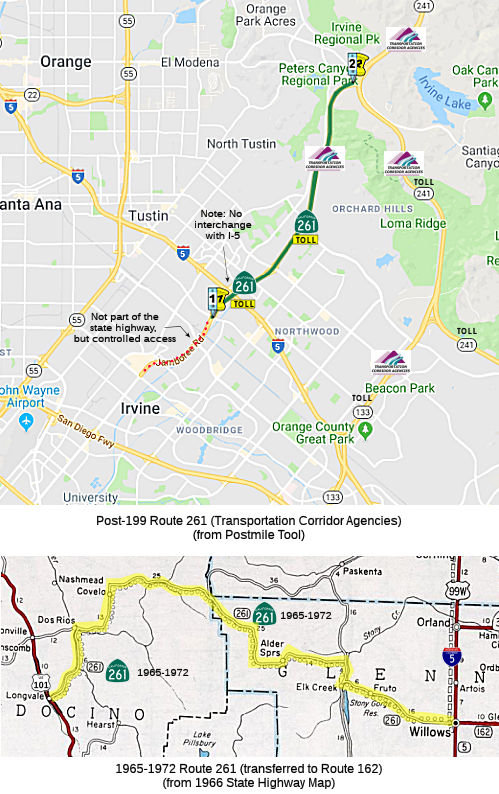
 From Walnut Avenue in the City of Irvine to Route 241.
 Post 1964 Signage History
 In 1965, Chapter 1372 defined Route 261 as “Route 101 near
Longvale to Route 5 near Willows via the vicinity of Covelo and Mendocino
Pass.” This same definition was also added by 1965 Chapter 1397;
this duplicate definition was removed in 1967 by Chapter 235.
In 1965, Chapter 1372 defined Route 261 as “Route 101 near
Longvale to Route 5 near Willows via the vicinity of Covelo and Mendocino
Pass.” This same definition was also added by 1965 Chapter 1397;
this duplicate definition was removed in 1967 by Chapter 235.
The original Route 261 was a planned highway over Mendocino Pass. Part of
the justification for its creation was the damage by the 1964 Christmas
Floods to the existing Covelo Road at the Eel River. Covelo Road is
the primary access point to Round Valley Indian Reservation. By 1969,
Route 261 had been constructed to state standards east of US 101 to the
Eel River in Dos Rios and west from I-5 to Elk Creek.
(Source: Gribblenation Blog (Tom Fearer), "California State Route 261", 1/21/2022)
In 1972, Chapter 1216 repealed the route definition and transferred the routing to Route 162.
By 1975, Former Route 261/Route 162 had been built to state standards
east from Dos Rios through Covelo to the boundary of Mendocino National
Forest. Route 162 would never be built to state standards through
Mendocino National Forest over Mendocino Pass but the through route exists
as National Forest Route 7 on Mendocino Pass Road.
(Source: Gribblenation Blog (Tom Fearer), "California State Route 261", 1/21/2022)
 During 1986, the Transportation Corridors Agencies (TCA) of Orange County were created. Corridors
governed by the TCA included: the Eastern Transportation Corridor,
Foothill Transportation Corridor and San Joaquin Hills Transportation
Corridor. 1987 Legislative Chapter 1413 allowed for transportation
corridors to be constructed by way of toll funds. The Eastern
Transportation Corridor was assigned as Route 231, and was originally
defined as "Route 5 near the border of the Cities of Tustin and Irvine to
Route 91." At this point, the TCA routes were Route 231 (I-5 near
Tustin/Irvine to Route 91 roughly along Jamboree Road) and Route 241 (I-5
near San Clemente to Route 231 near Santiago Canyon Road (County Sign Route S18) near
Irvine Lake). Route 133 was not part of the TCA system.
During 1986, the Transportation Corridors Agencies (TCA) of Orange County were created. Corridors
governed by the TCA included: the Eastern Transportation Corridor,
Foothill Transportation Corridor and San Joaquin Hills Transportation
Corridor. 1987 Legislative Chapter 1413 allowed for transportation
corridors to be constructed by way of toll funds. The Eastern
Transportation Corridor was assigned as Route 231, and was originally
defined as "Route 5 near the border of the Cities of Tustin and Irvine to
Route 91." At this point, the TCA routes were Route 231 (I-5 near
Tustin/Irvine to Route 91 roughly along Jamboree Road) and Route 241 (I-5
near San Clemente to Route 231 near Santiago Canyon Road (County Sign Route S18) near
Irvine Lake). Route 133 was not part of the TCA system.
In 1991, Route 133 was brought into
the TCA system, bringing changes to the route definitions. SB 732, Chapter
775 created a new definition of Route 261 as “Route 5 near the
border of the Cities of Tustin and Irvine to Route 231”, using a
routing transferred from former Route 231. Route 231 was changed to run
from the end of Route 133 to Route 91. Route 241 was truncated to run from
the Route 231/Route 241 junction near Bee Canyon and Limestone Canyon Park
to I-5. The legislative definition of Route 241 didn't need to change, as
the western end remained Route 231.
In 1996, Route 133 brought further changes. Chapter 1154
changed the origin of Route 261 from “Route 5 near the border of the
Cities of Tustin and Irvine” to “Walnut Avenue in the City of
Irvine” (Walnut Avenue and Jamboree). It also changed the terminus
to reflect the renumbering of Route 231 to Route 241: “Walnut Avenue
in the City of Irvine to Route 241.” This is part of the "Eastern
Toll Road", a toll road that is part of the Orange County Transportation
Corridors. At the same time, Route 231 was dropped. Route 241 became the
main backbone, running from I-5 near San Clemente to Route 91. Route 133
was extended to take over the former portion of Route 231 between Laguna
Canyon and Route 241.
According to Robert Cruickshank, the original road (Jamboree) was built as a joint project between the County of Orange and the City of Irvine, around 1989/90, to close a gap in Jamboree between Edinger and Barranca through the Tustin Marine Corps Air Station. The grade-separated interchange at Warner was constructed because as part of the agreement to build through the Marine base (now closed) the road had to have high sound walls and barbed wire atop those walls. The military may not have wanted a place where traffic would have been held up on their land, so that may have dictated the Warner interchange. In any event, since no state funds went into the construction of the road or maintenance of it, and since Jamboree was never a state route, the little freeway stub never got a state number. In the late 1990s, when the Route 261 toll road was being constructed, its builders decided to maximize travel speeds and times by constructing an interchange at Edinger, and another at Walnut (whereas before, there were simply stoplights). The result was that there was a freeway from Barranca northward, although Jamboree Road moves off of the freeway at the Walnut interchange. This was all part of a broader plan to improve road circulation between the new (in the early 1990s) developments in the Tustin Ranch area and the industrial parks in Irvine. There have always been plans to extend Tustin Ranch Road south from Walnut, through the old base, and connect with Von Karman Road at Barranca. This was to involve a grade-separated interchange at Edinger, like the one now at Jamboree, in large part because of the rail corridor that parallels Edinger near the old base.
 Pre 1964 Signage History
 The 1965-1972 routing (now Route 162) was not a state route before
1964. The route runs (signed as Route 162) along Covelo Road into Covelo.
It then runs E along Mendocino Pass Road (unsigned, but marked FH-7)
through the Mendocino National Forest. Mendocino Pass Road becomes Alder
Springs Road in Glenn County. Signage of the road resumes naer Elk Creek
when Route 162 exits the National Forest. The route enters Willows along
Wood Steet.
The post-1991 routing was not a defined part of the state highway system before 1991.
 Status
 Route 261 is the west leg of the Eastern Transportation
Corridor, a toll road in Orange County. The leg connects Route 241
(the Foothill Corridor) with Jamboree Road, just south of I-5 in Irvine.
The Eastern Transportation Corridor was constructed in three segments:
 Naming
 Classified Landcaped Freeway
The following segments are designated as Classified Landscaped Freeway:
| County | Route | Starting PM | Ending PM |
| Orange | 261 | 0.00 | 3.21 |
| Orange | 261 | 5.75 | 6.20 |
 Freeway
[SHC 253.1] Entire route.
 Exit Information
 Other WWW Links
 Statistics
Overall statistics for Route 261 (before consolidation with Route 231):
 Pre-1964 Legislative Route
In 1959, Chapter 1062 defined LRN 261 as “[LRN 238] near French Camp to [LRN 4]”. This is present-day Route 234 from present-day I-5 near French Camp to Route 99.
© 1996-2020 Daniel P. Faigin.
Maintained by: Daniel P. Faigin
<webmaster@cahighways.org>.
 Route 260
 Route 262