
 California Highways:
Click here for a key to the symbols used. An explanation of acronyms may be found at the bottom of the page.
 Routing
 Post 1964 Signage History
This route remains as defined in 1963.
 Pre 1964 Signage History
This was LRN 81, defined in 1933.
According to research done by Tom Fearer, LRN 81 was an adoption of the
already existing North Bank Road. North Bank Road can be seen on the
1917 California State Automobile Association Map of California. It is
first shown as LRN 81 on the 1935 Division of Highways Map of Del Norte
County.
(Source: Gribblenation Blog, "California State Route 197")
Sign Route 197 was not defined as part of the initial state signage of
routes in 1934. It is unclear what (if any) route was signed as Route 197
between 1934 and 1964. Sign Route 197 first appears on a state highway map
in 1964, and appears to have been first signed in 1969*.
(* Source: Gribblenation Blog, "California State Route 197")
 Status
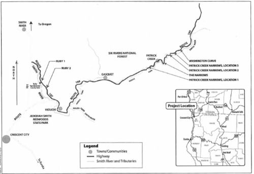
197/199 Safe STAA Access Project (01-DN-197, PM 3.2/4.5; 01-DN-199, PM 20.5/26.5; PPNO 01-1161)
 In December 2012, the CTC reviewed a draft EIR related to improvements on Route 197 and US 199 and
had no comments. The project will improve spot locations on Route 197 and
US 199 in Del Norte County so that two Surface Transportation Assistance
Act (STAA) trucks passing in opposite directions can be accommodated.
Within the project limits, Route 197 and US 199 are rugged, two-lane
conventional highways with tight curves and steep-cut slopes providing
narrow traffic lanes with narrow shoulders (if shoulders exist). Route 197
is the designated route for the movement of extralegal truck loads between
US 101 and US 199 because it avoids traversing Jedediah Smith Redwoods
Park. Known as North Bank Road, Route 197 was built in the 1930s. US 199
in the project limits traverses the Middle Fork Smith River and was built
in the early 1920s and is a tightly curved alignment with spectacular
views. The proposed work consists of roadway widening, shoulder widening,
roadway curve improvements, bridge replacements and culvert replacements.
The project will bring Route 197 and US 199 into compliance with federal
and state legislations regarding access for STAA trucks. It is split into
four projects: Ruby 1 (EA 48110, Route 197 PM 4.5) is fully funded
in the SHOPP Minor A Program. It would lengthen the curve and increase
shoulder width. Culverts and drainage would be adjusted. The total
estimated cost is $2,499,000. Construction is estimated to begin in Fiscal
Year 2013-14. Ruby 2 (EA 45490, Route 197, PM 3.2 to 4.0) is fully
funded in the SHOPP Minor A Program. This would improve the existing road
curve, roadbed elevation, and roadway width. Different alternatives have
slightly different roadway and shoulder widths. The total estimated cost
is $3,400,000. Construction is estimated to begin in Fiscal Year 2014-15.
Patrick Creek Narrows (PPNO 1047) will improve US 199 from Post
Mile 20.5 to 20.7, Post Mile 23.9 to 24.3, and Post Mile 25.55 to 25.65.
Most of these involve improving curves and slight roadway widening. It
would also replace the existing Middle Fork Smith River bridge with either
an upstream or downstream alternative, or rework the existing bridge to
allow large trucks to cross. The project is programmed in the 2012 STIP.
The total estimated cost for capital and support is $21,302,000.
Construction is estimated to begin in Fiscal Year 2012-13. The Narrows
and Washington Curve (PPNO 1073) will improve US 199 from Post Mile
22.7 to 23.0 (Narrows), and from PM 26.3 to 26.5 (Washington Curve). These
involve lane widening and curve improvement. The project is programmed in
the 2012 SHOPP. The total estimated cost for capital and support is
$6,750,000. Construction is estimated to begin in Fiscal Year 2015-16. For
these four projects, there are a total 12 build alternatives being
proposed as well as the no build alternative
In December 2012, the CTC reviewed a draft EIR related to improvements on Route 197 and US 199 and
had no comments. The project will improve spot locations on Route 197 and
US 199 in Del Norte County so that two Surface Transportation Assistance
Act (STAA) trucks passing in opposite directions can be accommodated.
Within the project limits, Route 197 and US 199 are rugged, two-lane
conventional highways with tight curves and steep-cut slopes providing
narrow traffic lanes with narrow shoulders (if shoulders exist). Route 197
is the designated route for the movement of extralegal truck loads between
US 101 and US 199 because it avoids traversing Jedediah Smith Redwoods
Park. Known as North Bank Road, Route 197 was built in the 1930s. US 199
in the project limits traverses the Middle Fork Smith River and was built
in the early 1920s and is a tightly curved alignment with spectacular
views. The proposed work consists of roadway widening, shoulder widening,
roadway curve improvements, bridge replacements and culvert replacements.
The project will bring Route 197 and US 199 into compliance with federal
and state legislations regarding access for STAA trucks. It is split into
four projects: Ruby 1 (EA 48110, Route 197 PM 4.5) is fully funded
in the SHOPP Minor A Program. It would lengthen the curve and increase
shoulder width. Culverts and drainage would be adjusted. The total
estimated cost is $2,499,000. Construction is estimated to begin in Fiscal
Year 2013-14. Ruby 2 (EA 45490, Route 197, PM 3.2 to 4.0) is fully
funded in the SHOPP Minor A Program. This would improve the existing road
curve, roadbed elevation, and roadway width. Different alternatives have
slightly different roadway and shoulder widths. The total estimated cost
is $3,400,000. Construction is estimated to begin in Fiscal Year 2014-15.
Patrick Creek Narrows (PPNO 1047) will improve US 199 from Post
Mile 20.5 to 20.7, Post Mile 23.9 to 24.3, and Post Mile 25.55 to 25.65.
Most of these involve improving curves and slight roadway widening. It
would also replace the existing Middle Fork Smith River bridge with either
an upstream or downstream alternative, or rework the existing bridge to
allow large trucks to cross. The project is programmed in the 2012 STIP.
The total estimated cost for capital and support is $21,302,000.
Construction is estimated to begin in Fiscal Year 2012-13. The Narrows
and Washington Curve (PPNO 1073) will improve US 199 from Post Mile
22.7 to 23.0 (Narrows), and from PM 26.3 to 26.5 (Washington Curve). These
involve lane widening and curve improvement. The project is programmed in
the 2012 SHOPP. The total estimated cost for capital and support is
$6,750,000. Construction is estimated to begin in Fiscal Year 2015-16. For
these four projects, there are a total 12 build alternatives being
proposed as well as the no build alternative
In June 2013, the CTC accepted the environmental document for Ruby 1, Ruby 2, Patrick Creek Narrows, and Narrows and Washington Curve.
In September 2020, it was reported that the Crescent
City Harbor District added support to the Del Norte Local Transportation
Commission for a project to bring Route 199 and Route 197 up to 1982
trucking standards. Harbor commissioners unanimously approved a resolution
reaffirming their support for the project, which has been stalled when
Friends of Del Norte, the Environmental Protection Information Center and
the Center For Biological Diversity obtained an injunction in 2014. The
Harbor District’s vote comes about two weeks after a federal judge
in the case awarded intervenor status to the Del Norte Local
Transportation Commission. According to a staff report, the Local
Transportation Commission argued that it is local elected officials, not
the litigants, who represent the public. The Del Norte Unified School
District Board of Trustees has also unanimously declared their support for
the STAA 197/199 project, stating that widening the road is also essential
for school buses. The $34 million project includes widening three curves
on US 199 and replacing a bridge that was built in 1924. It also consists
of widening two curves on Route 197 near Ruby Van Deventer County Park.
Caltrans’ goal is to make the project safer for trucks meeting the
1982 Surface Transportation Assistance Act (STAA) standard. The project
has been paid for with state and federal dollars since 2008 and was about
to enter the construction phase when Friends of Del Norte, EPIC and Center
For Biological Diversity initiated a lawsuit that stalled the project in
2014. The three conservation groups argued that allowing for the larger
STAA trucks would increase, rather than decrease the risk to safety on the
two roads. The three groups are also concerned about the possibility of a
hazardous material spill impacting the Smith River. However, restricting
the travel of trucks carrying hazardous materials down US 199 and Route 197 could circumvent that argument.
(Source: Wild Rivers Outpost, 9/1/2020)
 In March 2022, it was reported that a federal judge had lifted the injunction
that prevented Caltrans from completing road improvements on two highways
which, at many points, run directly alongside the wild Smith River.
Specifically, U.S. District Judge James Donato lifted the nearly
decadelong injunction after finding Caltrans’ revised plans for
improvements on US 199 and Route 197 did not violate the Magnuson-Stevens
Fishery Conservation and Management Act. Plaintiffs Friends of Del Norte,
an environmental group based in the state northwesternmost county, sued
Caltrans claiming plans for improving the highways posed a threat to the
salmon that inhabit the 25-mile river. The project had been intended to
facilitate the movement of large trucks. But in 2014 the judge found
"serious questions about the adequacy of the reviews and consultation
process that Caltrans and National Marine Fisheries Service conducted
under the Endangered Species Act.” At the time, the court found
“contradictions and critical gaps in reasoning” in the two
agencies’ assessments of the project's effects, and even whether a
formal consultation was required under the Endangered Species Act. Two
species of endangered salmon, coho and Chinook, inhabit the river along
with cutthroat and steelhead trout, according to the U.S. Geological
Survey. Rather than appealing, Caltrans launched a second round of
consultations with the Fisheries Service, which resulted in a revised
evaluation of the project’s potential effects.
In March 2022, it was reported that a federal judge had lifted the injunction
that prevented Caltrans from completing road improvements on two highways
which, at many points, run directly alongside the wild Smith River.
Specifically, U.S. District Judge James Donato lifted the nearly
decadelong injunction after finding Caltrans’ revised plans for
improvements on US 199 and Route 197 did not violate the Magnuson-Stevens
Fishery Conservation and Management Act. Plaintiffs Friends of Del Norte,
an environmental group based in the state northwesternmost county, sued
Caltrans claiming plans for improving the highways posed a threat to the
salmon that inhabit the 25-mile river. The project had been intended to
facilitate the movement of large trucks. But in 2014 the judge found
"serious questions about the adequacy of the reviews and consultation
process that Caltrans and National Marine Fisheries Service conducted
under the Endangered Species Act.” At the time, the court found
“contradictions and critical gaps in reasoning” in the two
agencies’ assessments of the project's effects, and even whether a
formal consultation was required under the Endangered Species Act. Two
species of endangered salmon, coho and Chinook, inhabit the river along
with cutthroat and steelhead trout, according to the U.S. Geological
Survey. Rather than appealing, Caltrans launched a second round of
consultations with the Fisheries Service, which resulted in a revised
evaluation of the project’s potential effects.
(Source: Missoula Current, 3/4/2023)
In December 2023, the CTC approved for future
consideration of funding the following project for which a Final
Environmental Impact Report (FEIR) and Addenda have been completed: 197/199
Safe STAA Access Project. Route 197 and US 199 in Del Norte
County. Construct improvements at spot locations on Route 197 and US 199
to reclassify the routes as part of the Federal Surface Transportation
Assistance Act (STAA) truck route network and to comply with federal and
state legislation and regional programs, plans, and policies to allow STAA
access. The project involves curve adjustment and widening lanes and
shoulders, in Del Norte County. (01-DN-197, PM 3.2/4.5; 01-DN-199, PM
20.5/26.5; PPNO 01-1161) The project is located on Route 197 from PM
3.2 to PM 4.5, in Del Norte County. The Department proposes to construct
improvements at spot locations on Route 197 and US 199 to reclassify the
routes as part of the Federal Surface Transportation Assistance Act (STAA)
truck route network and to comply with federal and state legislation and
regional programs, plans, and policies to allow STAA access. The project
involves curve adjustment and widening lanes and shoulders. The project is
currently programmed in the 2022 State Highway Operation and Protection
Program (SHOPP). The total programmed amount, which includes Right of Way
(Support and Capital), and Construction (Support and Capital) is
$60,000,000. Construction is estimated to begin in 2028-29. The scope, as
described for the preferred alternative, is consistent with the project
scope as programmed by the Commission in the 2022 SHOPP. A copy of the
FEIR has been provided to Commission staff. The Commission approved the
project for future consideration of funding on June 11, 2013, under
Resolution E-13-46. Since the approval of the FEIR, there have been
changes to the project and Addenda were prepared pursuant to the
California Environmental Quality Act (CEQA). The first Addendum was
prepared on January 31, 2013, after culvert drainage work was determined
not to impact jurisdictional waters of the U.S. or waters of the State,
and therefore would not require a 1600, 401, or 404 permit. The second
addendum was prepared on August 17, 2017, because of a lawsuit, and the
project was put under an injunction in May 2014. Accordingly, in May 2014,
the Department began the process of re-initiation of Endangered Species
Act and Magnuson- Stevens Fishery Conservation and Management Act
consultation with the National Marine Fisheries Service by preparing a new
Biological Assessment (BA). The Department submitted a new BA on March 30,
2017, and received a Letter of Concurrence on June 28, 2017, as described
in the Addenda. The project changes do not meet the criteria outlined in
CEQA Guidelines Section 15162 and Section 15163 to prepare a Subsequent or
Supplemental FEIR. The Department subsequently completed Addenda to the
FEIR pursuant to CEQA. The Department has approved this project for
construction. This approval and the Addenda will satisfy the environmental
requirements for this stage of the planning process.
(Source: December 2023 CTC Agenda, Agenda Item 2.2c.(2))
In December 2023, the CTC approved the following SHOPP
preconstruction-phase allocation:. $4,420,000. 01-DN-197 M3.2/4.5. PPNO
01-1161; ProjID 0123000202; EA 0N290. Route 197 Near Crescent City, from
Kaspar/Keene Road to Ruby Van Deventer County Park; also on US 199, from
0.7 mile north of Patrick Creek Bridge to 1.1 mile north of Siskiyou Fork
Road (PM 22.7/26.5). Improve cross slope, widen roadway, improve drainage,
replace guardrail, install rockfall wire mesh, and construct retaining
walls. Future consideration of funding approved under Resolution E-13-46;
June 2013. Concurrent addendum for the previously approved Future
Consideration of Funding under Resolution E-23-156A; December 2023.
Programmed (Allocation, if different): PS&E
$4,348,000; R/W Sup $72,000.
(Source: December 2023 CTC Agenda, Agenda Item 2.5b.(2) #1)
 Scenic Route
[SHC 263.1] Entire route.
 Other WWW Links
 Statistics
Overall statistics for Route 197:
 Pre-1964 Legislative Route
In 1933, Chapter 767 defined the route from "[LRN 77] near Escondido to El Cajon-Santa Ysabel Road near Ramona" as part of the state highway system. In 1935, this route was added to the highway code as LRN 197 with the routing:
This definition remained unchanged until the 1963 renumbering. The route ran from US 395 (present-day I-15) near Escondido to the Route 67/Route 78 junction near Ramona. This is present-day Route 78.
© 1996-2020 Daniel P. Faigin.
Maintained by: Daniel P. Faigin
<webmaster@cahighways.org>.
 From US
  Route 196
 Route 198