
 California Highways:
Click here for a key to the symbols used. An explanation of acronyms may be found at the bottom of the page.
 Routing
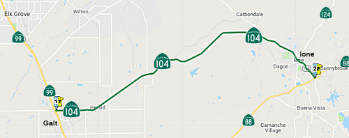 From Route 99 near Arno to Route 88 near Ione.
 Post 1964 Signage History
This segment was the original Route 104 as of 1963.
 Pre 1964 Signage History
This segment of Route 104 was part of the original 1934 signage of Route 104, which was defined as "Jct. Route 12 near Walnut Grove to Jackson via Galt".
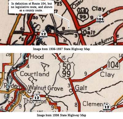 The portion from Route 12 (LRN 53) near Walnut Grove to
Route 99 (LRN 4) near Galt/Arno shows on state highway maps until 1938,
but the maps show it as a county route. It appears to have ran along
Walnut Grove Road and New Hope Road to Galt, where it joined the current
routings. That segment of Route 104 does not show on the state highway map
after 1938, so presumably the defnition was truncated to start at LRN 4 in
the 1937-1938 era. There is a possibility that the county road was signed
as Route 108, as county roads were sometimes signed as state routes. There
is also evidence that Route 12 was signed along a county route (see the
Route 12 page for an image of this) at some point, so this could have been
part of signed Route 12 ... or it could have been a signed Route 104 along
the county route. There were no LRNs defined as running from LRN 53 to LRN 4.
The portion from Route 12 (LRN 53) near Walnut Grove to
Route 99 (LRN 4) near Galt/Arno shows on state highway maps until 1938,
but the maps show it as a county route. It appears to have ran along
Walnut Grove Road and New Hope Road to Galt, where it joined the current
routings. That segment of Route 104 does not show on the state highway map
after 1938, so presumably the defnition was truncated to start at LRN 4 in
the 1937-1938 era. There is a possibility that the county road was signed
as Route 108, as county roads were sometimes signed as state routes. There
is also evidence that Route 12 was signed along a county route (see the
Route 12 page for an image of this) at some point, so this could have been
part of signed Route 12 ... or it could have been a signed Route 104 along
the county route. There were no LRNs defined as running from LRN 53 to LRN 4.
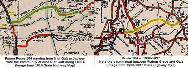
The portion from Route 99 to Jackson was part of LRN 34, defined as running from LRN 4 (current Route 99) near Arno to Jackson in 1909. Arno has disappeared as a formal community, but the 1918 state highway map shows it to be N of Galt; that map also shows a state highway continuing E from Galt which is presumably LRN 34 (future Route 104).
 Tom Fearer did some investigation on how the terminus of
this segment moved from Jackson to Ione: The 1935 Division of Highways Map
of Sacramento County shows LRN 34/Route 104 close to how it is presently
aligned. LRN 34/Route 104 has a slightly different alignment near Clay on
the 1935 map. Another map from that time, the 1935 California Division of
Highways Map of Amador County, shows the east terminus of Route 104/LRN 34
at Route 49 in Jackson on the present route of Route 88 rather than Ridge
Road. By the 1940 State Highway Map, Route 104 is shown as being consumed
by the new Route 88 east of Ione. Tom notes that it is unclear if Route 104 ended at Route 88 on Main Street in downtown Ione or was realigned to
Route 16 on LRN 97. By the 1957 state highway map, Route 104 is shown as
being routed northeast of Ione to Route 16 on LRN 97. It is likely this is
when the shift in Route 104 occurred due to the Route 88 being routed onto
a bypass of Ione by 1960.
Tom Fearer did some investigation on how the terminus of
this segment moved from Jackson to Ione: The 1935 Division of Highways Map
of Sacramento County shows LRN 34/Route 104 close to how it is presently
aligned. LRN 34/Route 104 has a slightly different alignment near Clay on
the 1935 map. Another map from that time, the 1935 California Division of
Highways Map of Amador County, shows the east terminus of Route 104/LRN 34
at Route 49 in Jackson on the present route of Route 88 rather than Ridge
Road. By the 1940 State Highway Map, Route 104 is shown as being consumed
by the new Route 88 east of Ione. Tom notes that it is unclear if Route 104 ended at Route 88 on Main Street in downtown Ione or was realigned to
Route 16 on LRN 97. By the 1957 state highway map, Route 104 is shown as
being routed northeast of Ione to Route 16 on LRN 97. It is likely this is
when the shift in Route 104 occurred due to the Route 88 being routed onto
a bypass of Ione by 1960.
(Source: Gribblenation Blog "California State Route 104", 7/15/2019)
In a thread on AARoads, Tom Fearer noted in June 2017 that Route 124 was
a post 1964 route created from parts of the original Route 104 alignment
and LRN 97. Originally it was Route 104 that ran north to Route 16 instead
of it running through downtown Ione eastward via what was an unsigned
portion of LRN 34 to Route 88. The state highway south of Ione was an
unsigned part of LRN 97, for some reason the route north out of Ione still
shows as a Route 104 but LRN 124 in 1964 but it finally shows the signage
change by 1965. Really the realignment of Route 104 made sense since the
route took a pretty wild north/south swing after being almost entirely
east/west. The 1935 Amador County Map shows LRN 97 running to Ione on Dave
Brubeck Road and maybe Marlette Street then using what became LRN 34 to
continue eastward to Jackson. That would certainly explain what the
thinking was with Route 104 in the early signed highway era. By 1940 the
state highway map shows Route 88 coming to Ione. By 1955, Route 88 is
still shown going through Ione but using part of the modern highway which
can be seen changing from 1954. In 1960, Route 88 is shown shifting
completely south of Ione in 1960.
(Source: AARoads "CA 124", June 2017)
In the same thread, Scott Parker noted that Ione has always been
something of a mess. Originally LRN 34 east of Jackson was signed as Route 8; this continued into Alpine County and out into Nevada (along present
Route 88). Route 104 remained on LRN 34 from Ione to Route 49 just north
of Jackson, where it terminated. In 1939 it was decided to terminate Route 8 in Jackson (the longstanding multiplex on Route 49 from Mokelumne Hill
to Jackson remained intact); a new route, Route 88, was commissioned over
all of LRN 34 east of Ione and over LRN 97 southwest of there to Stockton.
Instead of terminating Route 104 at new Route 88 in Ione, it was
redirected north over the remainder of LRN 97 to terminate at Route 16
west of Route 49; this left a few blocks of state-maintained LRN 34/LRN 97
in Ione unsigned, but (apparently; I've never seen specific evidence
published) with "trailblazer"/"TO" signage from each of the separate
signed alignments. This arrangement persisted until 1959, when the "88
Connector" south of Ione was built; technically a spur of LRN 97. Signage
was simple: from EB Route 88, the LRN 97 (west) turnoff was signed "Ione"
(with an arrow on a BBS), with an attached "TO"/"Route 104" shield array;
the LRN 34 (east) turnoff was likewise signed WB only. Within Ione proper,
the intersection where Route 104 turned from east to north was signed "TO
Route 88"; once the LRN 34/LRN 97 "split" was reached in downtown Ione,
trailblazers reading "TO EAST Route 88" and "TO WEST Route 88" were
posted. The '64 renumbering cleared things up considerably. Actual signage
(Route 104, Route 124) was now posted on the connectors, with Route 104 on
the previous LRN 34 and Route 124 on LRN 97. Also at that time the
connection (now on Route 124) north to Route 16 was realigned east of its
previous track; it now intersected Route 16 only a half-mile west of that
route's eastern terminus at Route 49 near Plymouth. The new alignment was
(and is) definitely a 2-lane CA-type "expressway", with very limited side
access. Presently Ione still maintains its historic "old gold rush
village" demeanor downtown, but there's a lot of modern housing around the
town's perimeter (including a lot of second homes for Sacramento and
Stockton residents).
(Source: AARoads "CA 124", June 2017)
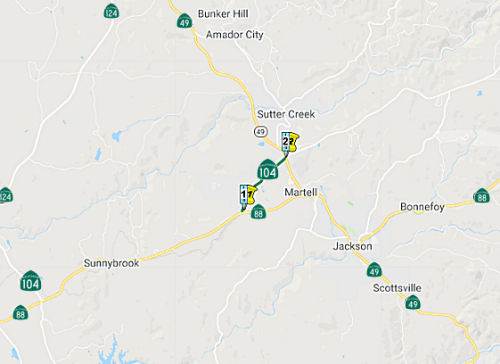 From Route 88 west of Martell to Route 88 southwest of Pine Grove via the
vicinity of Sutter Creek.
From Route 88 west of Martell to Route 88 southwest of Pine Grove via the
vicinity of Sutter Creek.
Post 1964 Signage History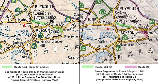 In 1970, Chapter 1473 added this segment and segment (c),
giving "(b) Route 88 west of Martell to Route 88 southwest of Pine Grove
via the vicinity of Sutter Hill. (c) Route 88 southwest of Pioneer Station
to Route 26 near West Point."
In 1970, Chapter 1473 added this segment and segment (c),
giving "(b) Route 88 west of Martell to Route 88 southwest of Pine Grove
via the vicinity of Sutter Hill. (c) Route 88 southwest of Pioneer Station
to Route 26 near West Point."
In 1984, Chapter 409 changed "Sutter Hill" to "Sutter Creek" and deleted (c). The former (c) was transferred to Route 26.
Tom Fearer noted in his blog: "The first segment of Route 104 on Ridge
Road can be seen on the 1975 State Highway Map along with the planned
highway eastward to West Point. Route 26 west of West Point is shown on
the 1977 State Highway Map as having Route 104 as the legislative route
number. [By] 1984 the legislative definition of Route 104 was cut back to
Sutter Creek. This effectively dropped the hidden designation of Route 104
over Route 26 between Route 88 and West Point. This change can be seen on
the 1986 State Highway Map.
(Source: Gribblenation Blog "California State Route 104", 7/15/2019)
Pre 1964 Signage HistoryThis segment was defined in 1970.
 Status
The traversable routing for this was along Ridge Road and Climax Road. As of 2002, there were plans to upgrade it to state standards. It currently appears to be signed and postmile marked through Sutter Ridge along Ridge Road.
The 2013 Traversable Highway report indicated that the following segment is Category 3 — The traversable highway is inadequate or nonexistent, but project studies are scheduled within five years so State assumption of maintenance is a possibility within the next ten years: From Route 49 to Route 88. (Ridge Road, Climax Road). (8.3mi) It also notes that the Study completed. No further action.
 Other WWW Links
 Statistics
Overall statistics for Route 104:
 Pre-1964 Legislative Route
In 1933, Chapter 767 defined the following segments, all of which became part of LRN 104:
In 1935, LRN 104 was defined in the highway code with the following definition:
In 1935, a new routing was defined for LRN 7, which filled a previous gap in LRN 7 between Benecia and the N end of the bridge, and obviated the need for (c) This was captured in 1937 by Chapter 841, which removed the American Canyon route and changed the east end of (b) from Shellville to Napa Y, making the definition for (b): "[LRN 1] near Petaluma to [LRN 8] near Napa Y"
In 1939, Chapter 473 changed the terminus of (b) back to Shellville.
The route was signed as follows:
© 1996-2020 Daniel P. Faigin.
Maintained by: Daniel P. Faigin
<webmaster@cahighways.org>.
 Route 103
 Route 105