
 California Highways:
Click here for a key to the symbols used. An explanation of acronyms may be found at the bottom of the page.
 Routing
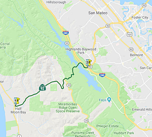 From Route 1 near Half Moon Bay to Route 280.
 Post 1964 Signage History
This segment is unchanged from its 1963 definition.
 In August 1965, it was reported that Alan S. Hart, state
highway district engineer, had announced three proposed routing for the
Route 92 freeway between Half Moon Bay and and Skyline Blvd. Alternative B
generally follows the present route along the northern side of Pilarcitos
Valley floor. Alternative M climbs the ridges to the S of the Valley. All
three leave Half Moon Bay about a block S of the present Half Moon Bay
Road/Main Street intersection, and cut across or close to the Mormon
Welfare Farm as they head east. Routes B and J join each other at the
eastern end of the valley, and follow the present route but higher up the
southern hillside, in a giant S-curve to meet Skyline Blvd. Route M also
follows a similar, but less sharp, curve. The freeway will cross Skyline
Blvd at Chaill Ridge, S of the present intersection, and then join a route
already adopted continuing on down the mountainside and across Crystal
Springs Lake. The Division of Highways indicated Route M for Route 92
would cost $11.7 million for the 3.5 mi project. This compares to the cost
of $14.5 million for the 3.9 B route, and $11.8 million for the 3.8 mi J
route. The B line would result in the loss of 33 structures, and the J
line crossing the valley would take 42 structures.
In August 1965, it was reported that Alan S. Hart, state
highway district engineer, had announced three proposed routing for the
Route 92 freeway between Half Moon Bay and and Skyline Blvd. Alternative B
generally follows the present route along the northern side of Pilarcitos
Valley floor. Alternative M climbs the ridges to the S of the Valley. All
three leave Half Moon Bay about a block S of the present Half Moon Bay
Road/Main Street intersection, and cut across or close to the Mormon
Welfare Farm as they head east. Routes B and J join each other at the
eastern end of the valley, and follow the present route but higher up the
southern hillside, in a giant S-curve to meet Skyline Blvd. Route M also
follows a similar, but less sharp, curve. The freeway will cross Skyline
Blvd at Chaill Ridge, S of the present intersection, and then join a route
already adopted continuing on down the mountainside and across Crystal
Springs Lake. The Division of Highways indicated Route M for Route 92
would cost $11.7 million for the 3.5 mi project. This compares to the cost
of $14.5 million for the 3.9 B route, and $11.8 million for the 3.8 mi J
route. The B line would result in the loss of 33 structures, and the J
line crossing the valley would take 42 structures.
(Source: Redwood City Tribune 8/26/1965, via email from Will
Poundstone, 1/1/2024)
 In 1967, the CHC considered the adoption of a freeway routing for 4 mi of
Route 92 between the E city limit of Half Moon Bay and Route 35 at Cahill
Ridge. The routing would complete the Route 92 freeway to the coast. The
recommended alignment starts at Half Moon Bay's eastern city limit on the
S side of Pilarcitos Creek Valley, then climbs SE into the hills at a 6%
grade. It continues S of the switchback curve on the existing highway to
join the previously adopted routing on Skyline Blvd.
In 1967, the CHC considered the adoption of a freeway routing for 4 mi of
Route 92 between the E city limit of Half Moon Bay and Route 35 at Cahill
Ridge. The routing would complete the Route 92 freeway to the coast. The
recommended alignment starts at Half Moon Bay's eastern city limit on the
S side of Pilarcitos Creek Valley, then climbs SE into the hills at a 6%
grade. It continues S of the switchback curve on the existing highway to
join the previously adopted routing on Skyline Blvd.
 Pre 1964 Signage History
This route runs along Half Moon Bay Road and San Mateo Road. It was
unsigned before 1964, and was part of LRN 105 (defined in 1933). Portions
may have been 3rd Avenue. LRN 105 ran between Half Moon Bay on an implied
path over the San Mateo-Hayward Bridge to Hayward, and then northward to
Oakland (current Route 185). Only the section of LRN 105 between Half Moon
Bay east Hayward ultimately became part of Route 92.
(Note: Some additional text adapted from Tom
Fearer's post California State Route 92, 2/15/2019, based on material from cahighways.org)
It appears the route for this was the San Mateo/Half Moon Bay Toll Road
from 1869-1913, with 24 hour manned toll houses collecting from the stage
coaches headed from San Mateo to Pescadero.
(Source: Comment from Dan Stegink in Half Moon Bay Review, 11/7/2020)
 to Rte 280") In 1962, the CHC considered adoption of a 1.9 mi freeway routing for Route 92
(LRN 105) in San Mateo County between Skyline Blvd at Cahill Ridge near
the intersection of Half Moon Bay Road and the adopted route for I-280 in
the vicinity of Ralson Ave. The recommended route follows an E/W course,
and connects with the previously adopted route for the 19th Avenue Freeway
(Route 92) E of the adopted route for I-280. It appears that this freeway
routing was never constructed.
In 1962, the CHC considered adoption of a 1.9 mi freeway routing for Route 92
(LRN 105) in San Mateo County between Skyline Blvd at Cahill Ridge near
the intersection of Half Moon Bay Road and the adopted route for I-280 in
the vicinity of Ralson Ave. The recommended route follows an E/W course,
and connects with the previously adopted route for the 19th Avenue Freeway
(Route 92) E of the adopted route for I-280. It appears that this freeway
routing was never constructed.
(Source: San Mateo Times, 11/28/1962 via Joel Windmiller, 2/16/2023)
 Status
An article on the Coastsider explored proposals to add tolls to Route 92
to keep visitor traffic at bay. Although “congestion pricing”
is an increasingly popular way to deter solo drivers from busy areas
during peak times, the addition of a toll to Route 92 is unlikely. There
are a number of reasons: (1) it is a non-freeway route; (2) the road is
just one lane in either direction; (3) historically, toll projects for
smaller roads lack sufficient political support; and (4) instituting an
all-lane toll would also require legislative action. Typically, for
a toll to be created, it has to be supported at the local level first,
through the San Mateo County Transportation Authority, the California
Coastal Commission and the MTC before going to Caltrans — which owns
the road — for approval. There aren’t many examples of tolls
on single-lane highways or in coastal areas. The closest parallel in the
Bay Area might be the toll on the single-lane Antioch Bridge over the San
Joaquin River. Another similar case is the 17-mile drive that charges
$10.50 per vehicle traveling along the Carmel coastline. However, it is a
private, not state, road. In 2019, Gov. Gavin Newsom vetoed a bill that
would have allowed a $10 weekend toll on the famous Lombard Street on the
grounds of equity. Equity is a concern most traffic experts share when it
comes to toll roads. Half Moon Bay Public Works Director John Doughty said
he doesn’t see a path toward tolling Route 92 without widening it
first, which would be an even bigger undertaking. Further, any project
that limits access to the coast would have to get approval from the
California Coastal Commission, which would analyze the project’s
impacts on coastal access. Goodwin said MTC is working now to roll out a
pilot program for toll discounts, but it’s still in development.
“Without having a lane in which you don't have to pay, that will be
seen as a social justice issue.”
(Source: Half Moon Bay Review, 11/7/2020)
 Naming
 Route 92 from Route 1 to Route 280 is named the "J.
Arthur Younger Freeway". Jesse Arthur Younger, born 11 April 1893,
Albany, Oregon, graduated from the University of Washington at Seattle,
1915, and served in World War I. He was the representative from the 9th
California Congressional District to the United States House of
Representatives, 1953-1967. He died 20 June 1967. Named by Senate
Concurrent Resolution 78, Chapter 188 in 1967.
Route 92 from Route 1 to Route 280 is named the "J.
Arthur Younger Freeway". Jesse Arthur Younger, born 11 April 1893,
Albany, Oregon, graduated from the University of Washington at Seattle,
1915, and served in World War I. He was the representative from the 9th
California Congressional District to the United States House of
Representatives, 1953-1967. He died 20 June 1967. Named by Senate
Concurrent Resolution 78, Chapter 188 in 1967.
(Biographical Information from the Online Archives of California; Image source: Wikipedia)
Portions of this route were named "Skyline Blvd" by Resolution Chapter 46 in 1919.
Historically, this route is close to the original "El Camino Real" (The Kings Road). A portion of this route has officially been designated as part of "El Camino Real by Assembly Bill 1707, Chapter 739, on October 11, 2001.
 Scenic Route
[SHC 263.5] Entire portion.
 Freeway
[SHC 253.5] Entire portion.
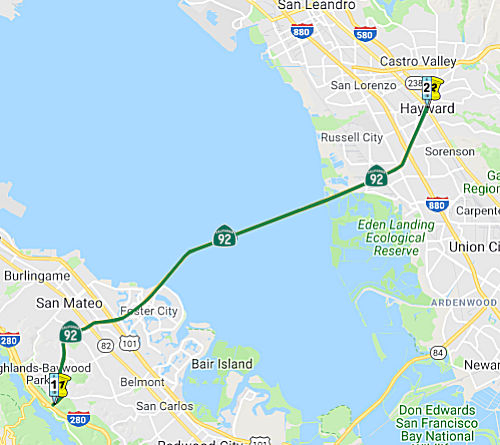 From Route 280 to Route 238 in Hayward.
(b) The relinquished former portion of Route 92 within the City of Hayward is not a state highway and is not eligible for adoption under Section 81. For the relinquished former portion of Route 92, the City of Hayward shall maintain within its jurisdiction signs directing motorists to the continuation of Route 92 or to the state highway system, as applicable.
(c) (1) The commission may relinquish to the City of Hayward all or any portion of Route 92 located within the city limits of that city, upon terms and conditions the commission finds to be in the best interests of the state, if the department and the city enter into an agreement providing for that relinquishment.
(2) A relinquishment under this subdivision shall become effective immediately after the county recorder’s recordation of the relinquishment resolution containing the commission’s approval of the terms and conditions of the relinquishment.
(3) On and after the effective date of the relinquishment, both of the following shall occur:
(A) The portion of Route 92 relinquished shall cease to be a state highway.
(B) The portion of Route 92 relinquished shall be ineligible for future adoption under Section 81.
(4) For relinquished portions of Route 92, the City of Hayward shall maintain signs within its jurisdiction directing motorists to the continuation of Route 92 or to the state highway system, as applicable.
Post 1964 Signage HistoryIn 2009, AB 1386 (Chapter 291, 10/11/2009) authorized the relinquishment of the portion of the route in the city of Hayward by adding the following:
(b) (1) The commission may relinquish to the City of Hayward the portion of Route 92 located within the city limits of that city, upon terms and conditions the commission finds to be in the best interests of the state, if the department and the city enter into an agreement providing for that relinquishment.
(2) A relinquishment under this subdivision shall become effective immediately after the county recorder's recordation of the relinquishment resolution containing the commission's approval of the terms and conditions of the relinquishment.
(3) On and after the effective date of the relinquishment, both of the following shall occur: (A) The portion of Route 92 relinquished shall cease to be a state highway. (B) The portion of Route 92 relinquished shall be ineligible for future adoption under Section 81.
(4) For relinquished portions of Route 92, the City of Hayward shall maintain signs within its jurisdiction directing motorists to the continuation of Route 92 or to the state highway system, as applicable.
In July 2010, the CTC approved relinquishment of right of way in the city of Hayward on Route 92 (Jackson Street) from Mission Boulevard to just south of Atherton Street, under terms and conditions stated in the letter dated June 1, 2010, determined to be in the best interests of the State. Authorized by Chapter 291, Statutes of 2009, which amended Section 392 of the Streets and Highways Code. In October 2017, they additionally relinquished right of way in the city of Hayward on Route 92 (Jackson Street) from Santa Clara Street to near Atherton Street.
In 2012, AB 2679 (Chapter 769, 9/29/2012) updated the language to reflect the relinquishment within the City of Hayward:
(b) The relinquished former portion of Route 92 within the City of Hayward is not a state highway and is not eligible for adoption under Section 81. For the relinquished former portion of Route 92, the City of Hayward shall maintain within its jurisdiction signs directing motorists to the continuation of Route 92 or to the state highway system, as applicable, and shall ensure the continuity of traffic flow on the relinquished portion of Route 92, including any traffic signal progression.
The 2013 Traversable Highways report noted, for the portion between Route 238 and I-580: Route was planned as a freeway. This segment was deleted from the F&E System in 1975. The route was rescinded 1/22/76. No recommendation.
In 2015, SB 491, Chapter 451, 10/2/15, changed the 1963 definition of this route as follows:
From Route 280 to Route 238 in 580
near Castro Valley and Hayward.
Chapter 451 (2015) also deleted the requirement regarding traffic signal progression from item (b):
(b) The relinquished former portion of Route 92 within
the City of Hayward is not a state highway and is not eligible for
adoption under Section 81. For the relinquished former portion of Route 92, the City of Hayward shall maintain within its jurisdiction signs
directing motorists to the continuation of Route 92 or to the state
highway system, as applicable, and shall ensure the continuity of
traffic flow on the relinquished portion of Route 92, including any
traffic signal progression.
Lastly, Chapter 451 (2015) also added section (c):
(c) (1) The commission may relinquish to the City of Hayward all or any portion of Route 92 located within the city limits of that city, upon terms and conditions the commission finds to be in the best interests of the state, if the department and the city enter into an agreement providing for that relinquishment.
(2) A relinquishment under this subdivision shall become effective immediately after the county recorder’s recordation of the relinquishment resolution containing the commission’s approval of the terms and conditions of the relinquishment.
(3) On and after the effective date of the relinquishment, both of the following shall occur:
(A) The portion of Route 92 relinquished shall cease to be a state highway.
(B) The portion of Route 92 relinquished shall be ineligible for future adoption under Section 81.
(4) For relinquished portions of Route 92, the City of Hayward shall maintain signs within its jurisdiction directing motorists to the continuation of Route 92 or to the state highway system, as applicable.
Scott Parker on AAroads notes:
(Source: Sparker on AAroads, "Re: CA 92", 2/15/2019)
The final nail in the coffin for any direct connection from Route 92 to I-580 near Castro Valley was the construction of multi-lane direct connectors from EB Route 92 to NB I-880, with traffic heading toward I-580 directed north and eventually east on I-238. The city of Hayward has done all in its power to divert through traffic, regardless of travel direction, away from downtown (specifically the multi-facility intersection at Mission & Jackson, formerly the junction of Route 92/Route 185/Route 238). Simply put, all parties involved want freeway traffic to remain on the freeways; at present I-880 through Hayward and San Lorenzo is being upgraded to accommodate the traffic taking that "detour". And to drive the point home, SB traffic on former Route 238 (Foothill Blvd.) has been diverted onto downtown streets, eventually spilling out onto former Route 185 to pass through the former multi-route junction -- more an arterial bypass than a "road diet".
Pre 1964 Signage HistoryThis route runs across the San Mateo Toll Bridge. It was unsigned before 1964. It is LRN 105 (defined in 1933) to Route 238 (former LRN 5), and LRN 259 (defined in 1959) between Route 238 and I-580 (former US 50). When it was unsigned (i.e., LRN 105), it appears to have run along Crystal Springs Avenue and 3rd Avenue in San Mateo.
The first San Mateo-Hayward Bridge was opened by the San Francisco Bay
Toll-Bridge company in March of 1929 as the San Francisco Bay toll bridge.
At the time of it's opening the 1929 San Mateo-Hayward Bridge was the
longest in the world at about 7 miles in length over San Francisco Bay.
The 1929 San Mateo-Hayward Bridge was mostly a causeway structure which
featured center vertical lift which had a 135 height above the water when
raised. In late 1951 the 1929 San Mateo Bridge was purchased by the
California Division of Highways for $6 million. This closed in much of the
gap in LRN 105 through San Mateo. Construction on a new bridge began in
1961 and was completed in 1967. Following the completion of the 1967 San
Mateo-Hayward Bridge the 1929 bridge was largely demolished. Access to the
1929 San Mateo-Hayward Bridge remains can be obtained at Bridgeview Park.
After much of the 1929 Bridge was demolished San Mateo County bought the
remaining western approach and operated it as a fishing pier until 1996
under land lease from the Division of Highways. While the 1929 Bridge is
no longer accessible the land was purchased by Foster City, which opened
Bridgeview Park in 2015. The 1929 Bridge next to the 1967 structure is
almost immediately apparent upon entering Bridgeview Park.
(Source: Gribblenation Blog (Tom Fearer): California State Route 92, 2/15/2019)
On the Gribblenation Blog California State Route 92, Tom Fearer provides the specifics of the changing of the routing of LRN 105 (future Route 92) along the approach to the San
Mateo bridge. This notes that LRN 105 in San Mateo originally was only
State Maintained between Route 1/LRN 56 in Half Moon Bay east to US 101/LRN 2 in San Mateo. LRN 105 began at Main Street/Route 1 in Half Moon
Bay and followed the modern course of Route 92 eastward over the Santa
Cruz Mountains to the Crystal Springs Reservoirs. From the Crystal Springs
Reservoirs LRN 105 followed Skyline Boulevard and Crystal Springs Road to
reach US 101/LRN 2 on El Camino Real in San Mateo. The implied connection
to the eastern segment of LRN 105 followed 3rd Avenue to the 1929 San
Mateo-Hayward Bridge. On the eastern side of the bridge, LRN 105 entered
downtown Hayward via Jackson Street to Mission Boulevard. Later, an
alignment along 19th Avenue in San Mateo was adopted.
(Source: Gribblenation Blog (Tom Fearer): California State Route 92, 2/15/2019)
 In March 1957, the routing was adopted for this freeway
(at the time, called the 19th Avenue Freeway). The routing
relocated the highway for eight miles between Skyline Blvd (then Signed
Route 5) and the San Mateo-Hayward Bridge. The remaining 3.9 miles were
along the existing bridge to the county line. The segment from the Alameda
County Line to ¼ mile NE of Harder Road (i.e., a bit NE of the
Eastshore Freeway (then Route 17, now I-880) near Soto Road) was adopted
in August 1952. The adopted 4-lane route swings southerly on a new
alignment from Skyline Blvd where the latter crosses Crystal Springs
Reservoir, then curves easterly in the vicinity of Canada Road and Ralston
Ave. It swings northerly for about 2¼ miles and turns easterly to run
north of 20th Ave and 19th Ave in San Mateo. It then runs the length of
19th Ave and continues easterly to and across the San Mateo-Hayward
Bridge. This will be the first E/W highway S of San Francisco that
connects East Bay communities with the coast.
In March 1957, the routing was adopted for this freeway
(at the time, called the 19th Avenue Freeway). The routing
relocated the highway for eight miles between Skyline Blvd (then Signed
Route 5) and the San Mateo-Hayward Bridge. The remaining 3.9 miles were
along the existing bridge to the county line. The segment from the Alameda
County Line to ¼ mile NE of Harder Road (i.e., a bit NE of the
Eastshore Freeway (then Route 17, now I-880) near Soto Road) was adopted
in August 1952. The adopted 4-lane route swings southerly on a new
alignment from Skyline Blvd where the latter crosses Crystal Springs
Reservoir, then curves easterly in the vicinity of Canada Road and Ralston
Ave. It swings northerly for about 2¼ miles and turns easterly to run
north of 20th Ave and 19th Ave in San Mateo. It then runs the length of
19th Ave and continues easterly to and across the San Mateo-Hayward
Bridge. This will be the first E/W highway S of San Francisco that
connects East Bay communities with the coast.
(Source: San Francisco Examiner, 3/27/1957 via Joel Windmiller, 1/18/2023)
On the EB Route 92 to SB US 101 ramp, the ramp momentarily widens to the
point where it could accommodate 3 lanes (but is only marked for 1 lane).
Then suddenly, on the left side of this ramp, the pavement simply ends.
From this point and beyond, the ramp is only wide enough for 1 lane (and 1
shoulder lane). From a different angle, it almost looks like the pavement
was supposed to continue and convert into a seperate flyover ramp,
connecting eastbound Route 92 with northbound US 101 (there's a cloverleaf
ramp connecting these 2 freeways as of today). This is a remnant of a
planned continuation of Route 92 (from US 101 to Ralston) that would have
been farther south than the route that actually got built. Before it was
finished, the interchange had a unique, goofy appearance: several ramps,
including part of that one, were concrete supported by wooden truss
structures. Route 92 from US 101 to the San Mateo Bridge used to have a
totally different routing. The very elaborate bridge that now supports
"Fashion Island Blvd." used to be part of Route 92. Traveling WB on Route 92 past the US-101 interchange, notice the guide-sign on the opposite
roadway, telling you about the upcoming exits. That sign is a little
farther away from its readers than is Caltrans' usual practice.. because
the roadways used to be much closer together; further, at that point, you
were driving uphill [from surface level up to the viaduct level] so that
sign was way above you as you approached it.
(Source: MTR postings by John David Galt and "Blue Plate")
Route 92/US 101 Interchange
With respect to the Route 92/US 101 interchange, there is more information in the draft EIR from 1979. Back in 1979, the section of Route 92 had an 0.7mi freeway gap, with an at-grade signalized intersection. The EIR concerned connecting freeway-to-freeway connectors (each replacing an existing ramp loop); reconstructing portions of the existing interchange; and building two new bridges across the Marina Lagoon. There were two alternatives under consideration. Alternate A is completion of the Route 92 freeway and reconstructing the interchange by replacing the loopramps in the southwest and northeast quadrants with direct freeway-to-freeway connections The loop ramps in the southeast and northwest quadrants would be structurally upgraded along with other parts of the interchange which are now temporary construction The nonfreeway section of Route 92 within the project limits would be reconstructed to freeway standards. This construction will include building two new bridges over Marina Lagoon. Alternate B is completion of the Route 92 freeway and reconstruction of the interchange by replacing all four loop ramps with direct freeway-to-freeway connections The gap in the freeway section of Route 92 will be completed in the same way as in Alternate A. The EIR notes that the Route 92/US 101 interchange was originally planned as a direct without loop ramps freeway-to-freeway interchange. This is the design of the interchange that is in the freeway agreement executed in 1967 between the City of San Mateo and the State of California. It was planned to construct the Route 92 freeway in this area and the interchange with Route 101 in a series of projects. This was necessary because of financing considerations and because this type of staged construction provided a good way to handle the detours and rerouted traffic. As part of this construction portions of the interchange and the segment of Route 92 connecting the interchange to Mariners Island were built on a temporary alignment. This portion of the staged project was constructed between 1967 and 1971. The temporary section of Route 92 includes the bridge over Marina Lagoon, a second temporary bridge spanning an adjacent lagoon, and an undivided section of highway that has a sharply curving alignment. Three structures of the interchange were built on temporary wood testle supported construction; these are the loop ramp in the southwest quadrant, the loop ramp in the southeast quadrant, and the connection between the permanent elevated section of westbound Route 92 and the temporary section of roadway leading to the top of the existing overcrossing. Alternative A was chosen to provide a lower cost alternative. Under Alternate A the interchange would be completed and the gap in the freeway portion of Route 92 would be closed as follows:
The EIR notes that Route 92 will be completed as a four
lane throughout the project. However because it necessary to provide for
the many merging and movements, there are locations where the ramps
freeway sections have increased roadway widths, and most of the freeway
within the project limits is wider than a standard section of four lane
freeway. The completed interchange will have three levels. The levels are
the two direct connections between Route 101 and Route 92. These
connections cross the interchange structures at a maximum height of 55'
above the ground.
(Source: Draft EIR Route 92 Gap Completion, 2/12/1979)
In June 2010, it was reported that studies are
beginning to improve the US 101/Route 92 interchange. Officials from three
local transit agencies are splitting a $450,000 study that by the end of
Summer 2011 should map out why cars move so slowly through the area, and
what can be done about it. The purpose of the study is to figure out if
there are any quick and easy fixes for operational problems in the
interchange. C/CAG, MTC and the county Transportation Authority will each
pay $150,000 to fund the study.
(Source: Oakland Tribune, 6/9/2010)
In March 2016, it was reported that state funding for
improvements to the US 101/Route 92 interchange that backs up traffic in
San Mateo has been eliminated. Members of the Metropolitan Transportation
Commission expressed frustration but approved a list of cuts, including
the one above. Funding may not be available until 2021.
(Source: SM Daily Journal, 3/28/2016)
In January 2018, it was reported that short- and
long-term ideas for the US 101 / Route 92 interchange are taking shape as
an early round of funding to consider options is coming together. The San
Mateo County Transportation Authority, or TA, is leading the project that
involves working with Caltrans, the City/County Association of
Governments, and the cities of Foster City and San Mateo. The project may
also align with fast-moving plans to create managed lanes across a San
Mateo County stretch of the congested US 101. Essentially, one of the
longer-term proposals is to construct new overpasses that would give
carpoolers and toll payers on Route 92 direct access to the managed lanes
in the center of US 101. Shorter-term ideas include widening certain
intersection ramps, reconfiguring lanes and eliminating the problematic
weave between commuters heading toward the San Mateo-Hayward Bridge. While
still early, nearly $3 million is being sought to prepare two documents
that will outline the scope of the longer-term “Direct Connector
Project” and the shorter-term “Interchange Area Improvements
Project.” That expense doesn’t include the environmental,
design or construction phases that cumulatively could cost more than $150
million. Suggested short-term improvements could happen in the next three
to five years. Alternatives include increasing capacity by adding a
carpool lane on the ramp from westbound Route 92 to southbound US 101.
Another option is to modify the Hillsdale Boulevard exit from northbound
US 101 to increase capacity and avoid spillover onto the freeway,
according to documents submitted to the TA. One proposal that includes
short- and long-term improvements is to add another lane on eastbound
Route 92 between US 101 to Mariners Island Boulevard. The goal is to
eliminate the short weaving distance between drivers from both directions
on US 101 trying to merge with others headed toward the bridge. The other
long-term suggestion is to create a quicker route for carpoolers by
creating new “connectors” or overpasses, from westbound Route 92 to both directions on US 101. That improvement would feed into the US 101 Managed Lanes Project, which suggests squeezing in a new lane in each
direction on the freeway. Located in the center, the express lanes would
be free for carpoolers with three people, and open to others willing to
pay a toll. That $593 million project is in the environmental review phase
with construction aiming to begin May 2019, according to Caltrans.
(Source: SM Daily Journal, 1/30/2018)
The 2018 STIP, approved at the CTC March 2018 meeting, appears to show that the 2016 STIP included funding for PPNO 0668D, Route 92/US 101 Interchange Improvements - Phase 2. In San Mateo. Reconstruct/Reconfigure Route 101/Route 92 Interchange. The purpose statement notes that the current level of service (LOS) on SR 92 at US 101 is F. The purpose of this project is to develop alternatives that address the current congestion and improve traffic safety at this location. The project has a total of $5.628M in the STIP: $2.411M in FY19-20 for Environmental and Planning, and $3.217M in FY 20-21 for PS&E.
The 2020 STIP, approved at the CTC March 2020 meeting,
shifted the programmed funding for PPNO 0668D "Rt 101 interchange
improvements" from FY20-21 to FY21-22.
(Source: March 2020 CTC Agenda, Item 4.7, 2020 STIP
Adopted 3/25/2020)
In May 2021, it was reported that local transit
agencies have begun public outreach for the US 101/Route 92 Short
Term Area Improvement Project, which will provide ramp and merger
improvements to four highway areas in San Mateo and Foster City. The
project would provide immediate low-cost construction options to improve
local ramp access from US 101, reduce weaving cars and improve overall
safety. Four improvement areas are being considered for construction
fixes. Area improvement one focuses on the westbound Route 92 to
southbound US 101 loop connector and would widen the loop connector ramp
and add a lane to increase capacity. Improvement two is for eastbound
Route 92, which seeks to improve heavy traffic and increase merging time.
It would eliminate the inside merge between eastbound Route 92 and
southbound US 101 and shift the existing merge points, although it would
not add a lane. Improvement three is to the southbound US 101 to westbound
Route 92 ramp. It would realign the Fashion Island Boulevard off-ramp and
segregate the eastbound and westbound Route 92 ramps to prevent illegal
motorist crossings. Improvement four addresses the northbound US 101 to
Hillsdale Boulevard exit ramp. It would widen and restripe the northbound
US 101 off-ramp, extend the eastbound through lanes through the northbound
US 101 and Hillsdale Boulevard intersection and realign the northbound US 101 loop on-ramp. Construction is estimated to start in April 2023, with
completion to be determined. The project total is estimated to be $28.6
million. If funding is not available for all four improvement areas,
Caltrans staff said each part could be constructed individually and would
be dependent on funding available.
(Source: San Mateo Daily Journal, 5/10/2021)
In July 2023, it was reported that MTC’s
Programming and Allocations Committee recommended allocations of Regional
Measure 3 toll dollars for this project. The committee's recommendation
will be considered by the full Commission at its July 26 2023 meeting. The
specific allocation was: San Mateo County Transportation Authority: $2
million for the environmental phase of the U.S. 101/State Route 92
Interchange Direct Connector Project in San Mateo.
(Source: MTG/ABAG Bay Link Blog, 7/12/2023)
In March 2016, it was reported that state funding for improvements to the
US 101/Route 92 interchange that backs up traffic in San Mateo has been
eliminated. Members of the Metropolitan Transportation Commission
expressed frustration but approved a list of cuts, including the one
above. Funding may not be available until 2021.
(Source: SM Daily Journal, 3/28/2016)
 With respect to the approach to the San Mateo Bridge: In 1960, the State Highway Engineer
proposed a freeway routing for Route 92 that moved Route 92 off 3rd Avenue
and on to 19th Avenue. The freeway routing was subsequently adopted and
constructed.
With respect to the approach to the San Mateo Bridge: In 1960, the State Highway Engineer
proposed a freeway routing for Route 92 that moved Route 92 off 3rd Avenue
and on to 19th Avenue. The freeway routing was subsequently adopted and
constructed.
(Source: via Joel Windmiller, 2/12/2023)
Mr. Roadshow of the Mercury News investigated the "kink" in the San Mateo
Bridge. This kink is the transition from the low-rise trestle section to
the high-rise section and it's due to how the trestle section was widened.
When the trestle section had only four lanes (two in each direction), the
median barrier in the center of the bridge for both the trestle and
high-rise sections made a relatively straight line. However, when the
trestle section was widened to six lanes, all of the widening was done
along the north side. The three westbound lanes are on the widened
structure; the three eastbound lanes are (mostly) on the old trestle
section. This meant that the six lanes on the trestle section are
laterally offset in relation to the six lanes on the high-rise section. As
for why the bridge was widened in two sections, Mr. Roadshow explained it
as follows. In those days, the old Division of Bay Toll Crossings was
responsible for the toll bridges in the region. Planners did not have the
funding to widen the entire span to six lanes, but they were looking ahead
to when six lanes might be needed and took the opportunity to build the
wider bridge. After that, economic conditions and overall funding
priorities kept the project low on the list of highway improvements until
voters approved a regionwide tax to make the bridge six lanes each way.
(San Jose Mercury News, 2/8/2013)
Status Freeway has been completed from Route 280, through San Mateo,
over the San Mateo Bridge, to .5 miles east of the Route 880 junction,
which is unconstructed at this point.
Freeway has been completed from Route 280, through San Mateo,
over the San Mateo Bridge, to .5 miles east of the Route 880 junction,
which is unconstructed at this point.
I-280 to the San Mateo Bridge (Foster City/US 101)
Route 92 / Route 82 Interchange Improvements (~ SM R11.162)
In June 2010, it was reported that studies are
beginning to improve the El Camino Real (Route 82)/Route 92 interchange.
Officials from three local transit agencies are splitting a $450,000 study
that by the end of Summer 2011 should map out why cars move so slowly
through the area, and what can be done about it. The purpose of the study
is to figure out if there are any quick and easy fixes for operational
problems in the interchange. C/CAG, MTC and the county Transportation
Authority will each pay $150,000 to fund the study.
(Source: Oakland Tribune, 6/9/10)
In January 2011, results from the study were disclosed. Five options are being considered. The favored option includes converting the existing cloverleaf configuration to a “partial cloverleaf” configuration. This would require the elimination of two loop ramps and the construction of diagonal off-ramps. Cost for the work is expected to be up to $15 million and San Mateo is currently sitting on a $2.8 million grant from the federal government for the design and construction of the project. The city is also seeking about $5 million for the project from the Metropolitan Transportation Commission. The focused study also favored an option that calls for constructing partial cloverleafs at the interchange with the widening of Route 92 by one lane in each direction. The other three options include:
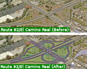
In February 2014, it was reported that the draft EIR for reconstruction of the El Camino Real/Route 92 interchanage was released for public comment. The current El Camino Real-Route 92 interchange is laid out in a full cloverleaf configuration, with four circular ramps guiding cars on and off the highway. The merging lanes are short and tricky to negotiate. Traffic on Route 92 often backs up as motorists slow down to exit or accommodate cars shifting from the onramp to the highway. Caltrans proposes dismantling two of the cloverleafs. The planned configuration would funnel vehicles leaving the highway to new three-way intersections with stoplights at El Camino Real. If the plan is approved in its current form, Caltrans expects to begin construction in 2017.
 In March 2015, it was reported that after entering into a cooperative
agreement last year, the city of San Mateo and Caltrans are collaborating
on a $16 million reconfiguration of the on- and off-ramps into a partial
cloverleaf design. The project will also entail two signalized
intersections that will accommodate drivers entering El Camino Real while
also providing safer crossings for bicyclists and pedestrians. San Mateo
has assumed landscaping responsibilities after the completion of the
project on top of its $2.75 million contribution — the majority of
which came from a federal grant and San Mateo County Transportation
Authority Measure A fund. Caltrans is taking the lead on the project as it
has the in-house design staff. In the future, drivers entering Route 92
from El Camino Real will continue to have access to separate eastbound and
westbound on-ramps. Those exiting Route 92 will only have one off-ramp in
either direction that would eventually widen into two or three lanes at a
signalized intersection allowing drivers to turn either north or south
onto El Camino Real (Route 82). The project will add two additional
intersections with traffic lights between Bovet Road and 20th Avenue. The
current design is about 65% complete and Caltrans hopes to begin
construction in July 2016 with the project completed around April 2018.
In March 2015, it was reported that after entering into a cooperative
agreement last year, the city of San Mateo and Caltrans are collaborating
on a $16 million reconfiguration of the on- and off-ramps into a partial
cloverleaf design. The project will also entail two signalized
intersections that will accommodate drivers entering El Camino Real while
also providing safer crossings for bicyclists and pedestrians. San Mateo
has assumed landscaping responsibilities after the completion of the
project on top of its $2.75 million contribution — the majority of
which came from a federal grant and San Mateo County Transportation
Authority Measure A fund. Caltrans is taking the lead on the project as it
has the in-house design staff. In the future, drivers entering Route 92
from El Camino Real will continue to have access to separate eastbound and
westbound on-ramps. Those exiting Route 92 will only have one off-ramp in
either direction that would eventually widen into two or three lanes at a
signalized intersection allowing drivers to turn either north or south
onto El Camino Real (Route 82). The project will add two additional
intersections with traffic lights between Bovet Road and 20th Avenue. The
current design is about 65% complete and Caltrans hopes to begin
construction in July 2016 with the project completed around April 2018.
(Source: San Mateo Daily Journal, 3/7/2015)
In October 2015, it was reported that the San Mateo
County Transportation Authority allocated $16.2 million toward the project
that will convert the dangerous Route 92/El Camino Real Interchange into a
partial cloverleaf, realign the off- and on-ramps and add signalized
intersections on El Camino Real. The project will improve safety by
eliminating the short weave distance between drivers merging on and off
Route 92 as well as deter existing backups when drivers spill onto the
westbound portion of the highway at El Camino Real. The project is in the
final design stages.
(Source: San Mateo Daily Journal, 10/2/2015)
In August 2016, the CTC approved a proposal from the Metropolitan Transportation Commission, the San Mateo City/County Council of Governments (C/CAG) and the San Mateo County Transportation Authority (SMCTA) to program an AB 3090 cash reimbursement project (PPNO 0668B) in order to use local funds for construction of the Route 92/Route 82 Interchange Improvements – Phase 1 project (PPNO 0668A) in San Mateo County. The San Mateo County Transportation Authority requested reimbursements over a two-year period beginning in Fiscal Year (FY) 2019-20. This project will reconstruct and reconfigure the existing interchange. Once completed, these improvements will result in increased operational efficiencies. SMCTA proposes to amend the STIP to revise the funding plan to advance project delivery with the use of $5,000,000 in local sales tax (Measure A) funds for construction support, and request reimbursements in FYs 2019-20 and 2020-21. This request follows AB 3090 Guidelines, which allow a local agency to use its own funds (non-state or non-federal) to complete a project component early to be later reimbursed with STIP funds currently programmed on the project.
In October 2016, the CTC approved the following STIP allocation: 04-SM-92 10.3/10.7; 11.0/11.5 | Route 92/Route 82 Interchange Improvements - Phase 1. In San Mateo. Modify existing on/off ramps at the Route 92/Route 82 interchange. It is proposed to remove the southeast and the northwest quadrant loops. Two new signalized intersections would be created at new on and off ramps on Route 82 (El Camino). $5,000,000
The Route 92/Route 82 interchange project in San Mateo was completed in early 2018, after several months in 2017 of realigning or removing the old ramps from the original cloverleaf.
Route 92/US 101 Interchange (SM 11.5/12.5)
In June 2010, it was reported that studies are
beginning to improve the US 101/Route 92 interchange. Officials from three
local transit agencies are splitting a $450,000 study that by the end of
Summer 2011 should map out why cars move so slowly through the area, and
what can be done about it. The purpose of the study is to figure out if
there are any quick and easy fixes for operational problems in the
interchange. C/CAG, MTC and the county Transportation Authority will each
pay $150,000 to fund the study.
(Source: Oakland Tribune, 6/9/10)
In March 2016, it was reported that state funding for
improvements to the US 101/Route 92 interchange that backs up traffic in
San Mateo has been eliminated. Members of the Metropolitan Transportation
Commission expressed frustration but approved a list of cuts, including
the one above. Funding may not be available until 2021.
(Source: SM Daily Journal, 3/28/2016)
In January 2018, it was reported that short- and
long-term ideas for the US 101 / Route 92 interchange are taking shape as
an early round of funding to consider options is coming together. The San
Mateo County Transportation Authority, or TA, is leading the project that
involves working with Caltrans, the City/County Association of
Governments, and the cities of Foster City and San Mateo. The project may
also align with fast-moving plans to create managed lanes across a San
Mateo County stretch of the congested US 101. Essentially, one of the
longer-term proposals is to construct new overpasses that would give
carpoolers and toll payers on Route 92 direct access to the managed lanes
in the center of US 101. Shorter-term ideas include widening certain
intersection ramps, reconfiguring lanes and eliminating the problematic
weave between commuters heading toward the San Mateo-Hayward Bridge. While
still early, nearly $3 million is being sought to prepare two documents
that will outline the scope of the longer-term “Direct Connector
Project” and the shorter-term “Interchange Area Improvements
Project.” That expense doesn’t include the environmental,
design or construction phases that cumulatively could cost more than $150
million. Suggested short-term improvements could happen in the next three
to five years. Alternatives include increasing capacity by adding a
carpool lane on the ramp from westbound Route 92 to southbound US 101.
Another option is to modify the Hillsdale Boulevard exit from northbound
US 101 to increase capacity and avoid spillover onto the freeway,
according to documents submitted to the TA. One proposal that includes
short- and long-term improvements is to add another lane on eastbound
Route 92 between US 101 to Mariners Island Boulevard. The goal is to
eliminate the short weaving distance between drivers from both directions
on US 101 trying to merge with others headed toward the bridge. The other
long-term suggestion is to create a quicker route for carpoolers by
creating new “connectors” or overpasses, from westbound Route 92 to both directions on US 101. That improvement would feed into the US 101 Managed Lanes Project, which suggests squeezing in a new lane in each
direction on the freeway. Located in the center, the express lanes would
be free for carpoolers with three people, and open to others willing to
pay a toll. That $593 million project is in the environmental review phase
with construction aiming to begin May 2019, according to Caltrans.
(Source: SM Daily Journal, 1/30/2018)
The 2018 STIP, approved at the CTC March 2018 meeting, appears to show that the 2016 STIP included funding for PPNO 0668D, Route 92/US 101 Interchange Improvements - Phase 2. In San Mateo. Reconstruct/Reconfigure Route 101/Route 92 Interchange. The purpose statement notes that the current level of service (LOS) on SR 92 at US 101 is F. The purpose of this project is to develop alternatives that address the current congestion and improve traffic safety at this location. The project has a total of $5.628M in the STIP: $2.411M in FY19-20 for Environmental and Planning, and $3.217M in FY 20-21 for PS&E.
The 2020 STIP, approved at the CTC March 2020 meeting,
shifted the programmed funding for PPNO 0668D "Rt 101 interchange
improvements" from FY20-21 to FY21-22.
(Source: March 2020 CTC Agenda, Item 4.7, 2020 STIP
Adopted 3/25/2020)
San Mateo Toll Bridge (~ SM R14.471 to ALA R3.459)
The San Francisco Bay Crossings Study, dated June 2002, had improvements to the San Mateo Bridge corridor as Alternative 3. This would be the addition of a second bridge to add additional lanes. Note that the current bridge is the 10th largest bridge structure in the world. Costs for the improvements and widening of the bridge run from $2.052 to $2.356 billion dollars. Contrast these with the costs for Alternative 4, described under I-380.
According to the San Jose Mercury News, there are plans in early 2009 to raise tolls on the San Mateo Bridge, likely $1, and likely to be applied to carpoolers as well. They may also add congestion pricing. This is being done to help support the cost of retrofitting the Dumbarton and Antioch spans for earthquake improvements. In February 2010, the toll increased to $5 at all times on the Dumbarton, San Mateo, Richmond-San Rafael, Carquinez, Benicia-Martinez and Antioch bridges. In July 2010, the toll will be extended to carpoolers, who will pay $2.50.
In July 2011, it was reported that Caltrans plans to shut down the San Mateo Bridge in both directions for two full weekends for a $10 million repair job in 2012. The bridge underwent a partial retrofit that included adding a 30-foot-long, wishbone-shaped steel beam just east of the incline section in 1999. In October 2010, however, inspectors discovered a 10-inch crack in the beam - apparently caused by the movement of a steel plate that wobbles every time a heavy truck rolls over it. The closure is to install a permanent solution.
In September 2019, it was reported that the Metropolitan Transportation
Commission gave the green light on a $4 million contract with a consultant
for an all-electronic tolling system for all bay area bridges, except the
Golden Gate which is its own district and has already gone cashless..
Drivers must pay with FasTrak only. For those without FasTrak, cameras
will capture your license plate and you'll get a bill in the mall. The
commission said it will save drivers time and the agency money. Drivers
won't have to slow down to squeeze through a toll booth. Toll booths will
be removed. The commission anticipates realistically it could take up to
five years for the system to go into effect. The Carquinez Bridge will
likely be the first to go cashless. MTC said engineers say it's a good
test bed to move faster on the others. The Bay Bridge will be likely be
last since it's the busiest. The toll authority first authorized the move
to all-electronic, open road tolling in December 2018. The consultants
jsut approved will be responsible for developing the toll system’s
specifications, providing oversight of the program’s implementation,
reviewing design plans, and help to develop policies for all-electronic
tolling. Bridges under the purview of the toll authority include the
Antioch Bridge, Benicia-Martinez Bridge, Carquinez Bridge, Dumbarton
Bridge, Richmond-San Rafael Bridge, San Mateo-Hayward Bridge and the San
Francisco-Oakland Bay Bridge.
(Source: KTVU, 9/1/2019; SFExaminer,
9/4/2019)
East Bay to Route 238 in Hayward (~ ALA R3.459 to ALA 8.027)
I-880 / Route 92 Interchange (~ ALA R6.103)
The SAFETEA-LU act, enacted in August 2005 as the reauthorization of TEA-21, provided the following expenditures on or near this route:
Caltrans recently rebuilt the Route 92/I-880 interchange. The original interchange was a conventional cloverleaf interchange, with collector/distributor roads on I-880. The new $245 million interchange has 3 levels: I-880 at the bottom; Route 92 West next, with a left-hand ramp to I-880 South; Route 92 East at the top, soaring over both I-880 and the Route 92 West/I-880 South transition ramp. The project will take out business and/or homes west of I-880 south of Route 92, and either east or west of I-880 north of Route 92, depending on which alignment Caltrans picks. In 2010, it was reported that the estimated completion for this project is in late 2012. It was actually reopened in October 2011. About 235,000 vehicles pass through the interchange daily as of 2011. The project, constructed by Flatiron Construction and Granite Construction, was completed on schedule and about $1 million under budget.
In October 2017, the CTC authorized relinquishment of right of way in the city of Hayward on Route 92 (Jackson Street) from Santa Clara Street to near Atherton Street (04-Ala-92-PM 6.8/8.1), under terms and conditions as stated in the relinquishment agreement dated August 29, 2017, determined to be in the best interest of the State. Authorized by Chapter 451, Statutes of 2015, which amended Section 392 of the Streets and Highways Code.
The portion of (2) From Route 238 to Route 580 is
unconstructed, but roughly parallels Grove Way and A Street. The routing
is along Jackson Street, and it dumps into Route 238 at Mission Blvd. The
Route 238 - I-580 segment was planned as freeway, but deleted from the
Freeway and Expressway system in 1975. The route was rescinded effective
1/22/1976. There are no plans to complete this segment. It was deleted
from the route in 2015.
 Commuter Lanes
This route has HOV lanes on the westbound approach to the San Mateo Bridge, from Hesperian Blvd to west of the toll plaza, for a total length of 2.0 mi. They opened in October 1989 and were extended in 1992, with the EB end relocated from the Clawiter Road on-ramp to Hesperian Blvd as part of the San Mateo Bridge Widening project completed in January 2003. They require two or more occupants, and are in operation on weekdays between 5:00 AM and 10:00 AM and between 3:00 PM and 6:00 PM.
NamingRoute 92 from Route 280 to the San Mateo/Hayward
Bridge is named the "J. Arthur Younger Freeway". Jesse Arthur
Younger, born 11 April 1893, Albany, Oregon, graduated from the University
of Washington at Seattle, 1915, and served in World War I. He was the
representative from the 9th California Congressional District to the
United States House of Representatives, 1953-1967. He died 20 June 1967.
Named by Senate Concurrent Resolution 78, Chapter 188 in 1967.
(Biographical Information from the Online Archives of California; Image source: Wikipedia)
 The interchange at I-880 (ALA 880 16.664) and Route 92 (ALA 092 6.328) in the County of
Alameda is named the CHP Officer Andrew J. Camilleri Memorial
Interchange. It was named in memory of Andrew Joseph Camilleri,
Sr., who was born in February 1984 in San Jose, California. Officer
Camilleri graduated from Merrill F. West High School in Tracy, California,
in 2002, and worked for Clark Pest Control for 13 years after graduation.
Officer Camilleri, badge number 21653, graduated from the California
Highway Patrol Academy in 2017 and was assigned to patrol the Hayward area
upon graduation, where he proudly served for 16 months before making the
ultimate sacrifice. California Highway Patrol Officer Camilleri was killed
in the line of duty on December 24, 2017, when an errant driver traveling
southbound on I-880 collided with his patrol vehicle. Officer Camilleri
was transported to St. Rose Hospital, where he ultimately succumbed to his
injuries. Named by Assembly Concurrent Resolution (ACR) 120, Res. Chapter
39, 09/14/20.
The interchange at I-880 (ALA 880 16.664) and Route 92 (ALA 092 6.328) in the County of
Alameda is named the CHP Officer Andrew J. Camilleri Memorial
Interchange. It was named in memory of Andrew Joseph Camilleri,
Sr., who was born in February 1984 in San Jose, California. Officer
Camilleri graduated from Merrill F. West High School in Tracy, California,
in 2002, and worked for Clark Pest Control for 13 years after graduation.
Officer Camilleri, badge number 21653, graduated from the California
Highway Patrol Academy in 2017 and was assigned to patrol the Hayward area
upon graduation, where he proudly served for 16 months before making the
ultimate sacrifice. California Highway Patrol Officer Camilleri was killed
in the line of duty on December 24, 2017, when an errant driver traveling
southbound on I-880 collided with his patrol vehicle. Officer Camilleri
was transported to St. Rose Hospital, where he ultimately succumbed to his
injuries. Named by Assembly Concurrent Resolution (ACR) 120, Res. Chapter
39, 09/14/20.
(Image source: Officer Down Memorial Page)
 Named Structures
 Johnson") Bridge 35-0252 on US 101, the Route 92/Route 101 Interchange in San Mateo (SM R011.78), is
named the "Harold "Bizz" Johnson Interchange". Congressman Harold
T. "Bizz" Johnson, state Senator from 1949 to 1958, who served in the
House of Representatives from 1958-1980, was instrumental in helping
establish the Rails-to-Trails program. He also promoted water development
projects and sided with consumer-owned electric utilities against the
economic and political clout of big investor-owned systems like Pacific
Gas and Electric Co. He also successfully broadened language in the
Surface Transportation Assistance Act to allow bridges over highways,
railroads and other physical features to qualify for funding under the
Act's bridge replacement provisions. It was built in 1971, and was named
by Senate Concurrent Resolution 42, Chapt. 155 in 1985.
Bridge 35-0252 on US 101, the Route 92/Route 101 Interchange in San Mateo (SM R011.78), is
named the "Harold "Bizz" Johnson Interchange". Congressman Harold
T. "Bizz" Johnson, state Senator from 1949 to 1958, who served in the
House of Representatives from 1958-1980, was instrumental in helping
establish the Rails-to-Trails program. He also promoted water development
projects and sided with consumer-owned electric utilities against the
economic and political clout of big investor-owned systems like Pacific
Gas and Electric Co. He also successfully broadened language in the
Surface Transportation Assistance Act to allow bridges over highways,
railroads and other physical features to qualify for funding under the
Act's bridge replacement provisions. It was built in 1971, and was named
by Senate Concurrent Resolution 42, Chapt. 155 in 1985.
(Image sources:Wikipedia)
Bridge 35-0252, on US 101, the Route 92/Route 101 Interchange in San Mateo (SM R011.78), is also named the "Leslie Charlene Curtis Memorial Bridge". This name was assigned by Assembly Concurrent Resolution 84, Chapter 129, in 1985. Leslie Curtis was killed in an auto accident at this location.
Bridge 35-0054 (SM R014.44), over San Francisco Bay, is named the "San Mateo-Hayward Bridge". It as built in 1967. It replaced an earlier bridge at this location.
Pre 1964 Signage HistoryRoute 92 was not defined as part of the initial state signage of routes in 1934. It is unclear what (if any) route was signed as Route 92 between 1934 and 1964.
 Classified Landcaped Freeway
The following segments are designated as Classified Landscaped Freeway:
| County | Route | Starting PM | Ending PM |
| San Mateo | 92 | R8.83 | R9.54 |
| San Mateo | 92 | R10.01 | R11.77 |
| San Mateo | 92 | R12.00 | R12.28 |
| San Mateo | 92 | R12.60 | R13.84 |
| San Mateo | 92 | R13.95 | R14.32 |
| Alameda | 92 | 2.41 | 2.85 |
| Alameda | 92 | 4.27 | 6.23 |
Freeway Exit Information
 Other WWW Links
 Statistics
Overall statistics for Route 92:
 Pre-1964 Legislative Route
In 1933, the segment from "[LRN 65] near Coloma to Marshall's Monument" was added to the highway system. In 1935, that routing was defined as LRN 92, and remained unchanged until the 1963 renumbering. It ran from Route 49 near Columa to Marshall's Monument. This is present-day unsigned Route 153.
© 1996-2020 Daniel P. Faigin.
Maintained by: Daniel P. Faigin
<webmaster@cahighways.org>.
 Route 91
 Route 93