
 California Highways:
Click here for a key to the symbols used. An explanation of acronyms may be found at the bottom of the page.
 Routing
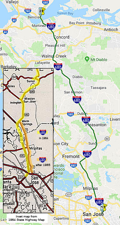 From Route 101 near San Jose to Route 780 at Benicia passing near Warm Springs,
Mission San Jose, Scotts Corners and Sunol, and via Walnut Creek.
From Route 101 near San Jose to Route 780 at Benicia passing near Warm Springs,
Mission San Jose, Scotts Corners and Sunol, and via Walnut Creek.
 Post 1964 Signage History
▸In 1963, Route 680 was defined as "Route 280 in San Jose to Route 80 in Vallejo passing near Warm Springs, Mission San Jose, Scotts Corners and Sunol, and via Walnut Creek and Benicia.". The 1964 routing is illustrated to the right.
▸In 1965, Chapter 1371 changed the origin of the route: "Route 280 Route 101 near San Jose to Route 80 in Vallejo
passing near Warm Springs, Mission San Jose, Scotts Corners and Sunol, and
via Walnut Creek and Benicia."
▸In 1976, Chapter 1354 added a second segment and change terminus
of (a): "(a) Route 101 near San Jose to Route 780 in
Vallejo at Benicia passing near Warm Springs, Mission
San Jose, Scotts Corners, and Sunol, and via Walnut Creek and
Benecia. (b) Route 780 at Benicia to Route 80 near Cordelia."
This was the result of a transfer from Route 21, combined with a
concurrent transfer to new I-780.
Portions of this segment was once signed as Route 21 (and for a while,
during the numbering changeover, was cosigned as Route 21). The beginning
of the 1963 segment (b) of Route 17 [Route 101 near San Jose...] (as
opposed to "at Story Road", which is in the definition of I-280) could
imply that instead of the second segment of Route 17 representing current
I-680 between US 101 and Route 262, the 1963 notion represented the
surface street routing along Oakland Road (later to be signed as Route 238), with I-680 being the only legislatively defined number for all of
current Route 262 and all of the Route 17/I-880 from I-280 to Route 262.
This might imply that the segment of I-680 from Route 262 to US 101 was
first planned in 1965.* It appears the original plans were for
Route 17 to have turned east in San Jose onto what is now I-280, crossed
US 101, and then joined with I-680 in Fremont using the present-day I-680
alignment. I-280 would have turned north on present-day I-880 (then signed
as Route 17) at Route 17, switched to I-680 at US 101, and then would have
joined the proposed Route 17 at Fremont near Route 262. Apparently, Route 17 would have crossed over somewhere at that point to its then-existing
routing up to Oakland.
(Source: Credit for the surmising regarding 1963-1965 I-680 should
go to Chris Sampang)
At this time (i.e., before the section south of Fremont opened), I-680 was routed along present-day I-880 to US 101 in San Jose. The section from Mission Blvd to Route 237 opened in 1971, and the section south of that opened in 1974. The I-280/US 101 interchange opened in 1982. For a time, I-680 was routed along Route 17 (now I-880) to Route 237, across Route 237, and then up the current I-680 from Route 237.
There is also a maintenance facility at the southwest corner of Scott Creek Road. It was originally acquired by Caltrans for a freeway that was going to connect I-680 to I-880. This freeway was killed by Gov. Jerry Brown in the 1970s.
After the new I-680 alignment was finalized, Oakland Road and Main Street were signed as Route 238, since that portion of Mission Blvd south of the present terminus of Route 238 was signed as Route 238 to Warm Springs. Today's I-880 freeway was signed as Route 17 and Temporary I-680 north of US 101 to the junction of Route 262 and Route 17 and Temporary I-280 south of US 101 to the junction of US 280. Note that Mission Blvd crosses I-680 twice. At the first (northern) crossing it is signed as Route 238 and this is the present terminus of Route 238. At the second (southern) crossing it is signed as a connection to I-880; this is the eastern terminus of (unsigned) Route 262. Also, the city of Milpitas built a new alignment for Main Street, so present-day maps do not show how Oakland Road connected with Mission Blvd in Warm Springs via Main Street.
When I-680 was built in the hills through Fremont's east side in the 1963-1964, an overpass and roadway was also constructed heading northwest where I-680 now turns east up through Mission Pass, between the Washington Boulevard and Auto Mall Parkway exits. That section, about 1,000 feet long, was the start of the aborted Mission Freeway that was to have run northwest under Lake Elizabeth through the middle of Fremont and Union City to connect with I-580 in Hayward. These plans were scuttled in the 1970s. This "bridge to nowhere" was demolished in 2002 to accomodate widening of I-680, and the southbound carpool lane construction. Caltrans still owns property on the north side of the curve east of Osgood that it has used for construction staging. However, the Caltrans Bridge Log dates the bridge as 1971, and refers to it as "FUTURE 238/680". This has left a mysterious exit-like area off I-680 in Fremont.
In Walnut Creek circa 1960, Route 21 ran along Main Street, while Route 24 had the freeway routing. As of 1960, the freeway routing ran only as
far as Boyd St, at which point it dumped NB traffic back onto Main Street.
This can still be seen in the structure of the offramps today.
(Source: Mark Harrigan in the 680/24 Corridor History FB Group, 8/10/2020)
 In 1957, the CHC released a map of the three proposed routings for the San
Ramon Freeway (Sign Route 21, future I-680) between Danville and the
Contra Costa/Alameda County Line. Residents were equally divided over the
A and R lines. The S line had been ruled out as not practical.
In 1957, the CHC released a map of the three proposed routings for the San
Ramon Freeway (Sign Route 21, future I-680) between Danville and the
Contra Costa/Alameda County Line. Residents were equally divided over the
A and R lines. The S line had been ruled out as not practical.
(Source: Contra Costa Times, 5/13/1957, via Joel Windmiller,
2/23/2023)
 In January 1955, the California Highway Commission adopted a freeway routing for then
Route 21 (future I-680) between Danville and Walnut Creek. The route runs
along the E side of San Ramon Creek and generally parallels the existing
Route 21 about 1,000 to 2,000 ft. to the E. Beginning 1 mi. S of Danville,
it bypasses that community to the E and extends to Circle Drive in Walnut
Creek, a distance of approx. 6½ mi.
In January 1955, the California Highway Commission adopted a freeway routing for then
Route 21 (future I-680) between Danville and Walnut Creek. The route runs
along the E side of San Ramon Creek and generally parallels the existing
Route 21 about 1,000 to 2,000 ft. to the E. Beginning 1 mi. S of Danville,
it bypasses that community to the E and extends to Circle Drive in Walnut
Creek, a distance of approx. 6½ mi.
(Source: Contra Costa Gazette, 1/27/1955 and Oakland Tribune,
1/27/1955 via Joel Windmiller, 1/27/2023)
The last segment of I-680 opened in August 1966, between Danville and Dublin.
The Benicia-Martinez bridge opened on September 15, 1962, replacing a
ferry. The 1962 Benicia-Martinez Bridge is an approximately 1.7 mile long
truss span design that now serves as the southbound lanes of I-680. The
1962 Benicia-Martinez Bridge was built immediately west of 1930 Union
Pacific Bridge which still is the longest rail bridge west of the
Mississippi River in the United States.
(Includes material from Gribblenation Blog: Interstate 680 over the Benicia-Martinez Bridge and the legacy of California State Route 21, 2/22/2019)
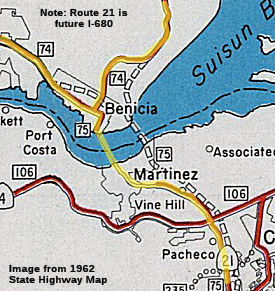 Before the Benicia-Martinez Bridge opened in 1962 traffic
on Route 21 had to take a ferry crossing over Carquinez Straight. Traffic
on Route 21 northbound entered a ferry route located on Court Street north
of downtown Martinez, which crossed Carquinez Straight to 5th Street in
Benicia. The alignment of Route 21 between Martinez to Benicia on the
ferry route can be seen in it's final form on the 1962 State Highway Map.
The Martinez-Benicia Ferry began operation in 1847 and is the second
oldest ferry in the San Francisco Bay Area. The Martinez-Benicia Ferry was
founded by Dr. Robert Semple and was taken over by Oliver Coffin
(interesting last name) who built the Ferry Street Wharf in 1850. By 1915
a steam ferry known as the City of Seattle was the first to carry
automotive traffic across the Carquinez Straights. When the 1962 bridge
opened, the Benicia-Martinez Ferry made its last trip across the Carquinez
Straits. This marked not only the end of the state-operated ferry system,
but also the end of 115 years of ferry service in the San Francisco Bay
area (except for a new Tiburon commuter vessel). The M.V. Carquinez was
been sold to the State of Florida for $86,001. It will be used as a part
of the State of Florida's ferry system across the mouth of the St. Johns
River on the Atlantic Coast east of Jacksonville.
Before the Benicia-Martinez Bridge opened in 1962 traffic
on Route 21 had to take a ferry crossing over Carquinez Straight. Traffic
on Route 21 northbound entered a ferry route located on Court Street north
of downtown Martinez, which crossed Carquinez Straight to 5th Street in
Benicia. The alignment of Route 21 between Martinez to Benicia on the
ferry route can be seen in it's final form on the 1962 State Highway Map.
The Martinez-Benicia Ferry began operation in 1847 and is the second
oldest ferry in the San Francisco Bay Area. The Martinez-Benicia Ferry was
founded by Dr. Robert Semple and was taken over by Oliver Coffin
(interesting last name) who built the Ferry Street Wharf in 1850. By 1915
a steam ferry known as the City of Seattle was the first to carry
automotive traffic across the Carquinez Straights. When the 1962 bridge
opened, the Benicia-Martinez Ferry made its last trip across the Carquinez
Straits. This marked not only the end of the state-operated ferry system,
but also the end of 115 years of ferry service in the San Francisco Bay
area (except for a new Tiburon commuter vessel). The M.V. Carquinez was
been sold to the State of Florida for $86,001. It will be used as a part
of the State of Florida's ferry system across the mouth of the St. Johns
River on the Atlantic Coast east of Jacksonville.
(Includes material from Gribblenation Blog: Interstate 680 over the Benicia-Martinez Bridge and the legacy of California State Route 21)
Note that, prior to 1931, the Martinez-Benecia Ferry carried US 40.
Access to the Martinez-Benicia Ferry was by way of LRN 14 and LRN 7. LRN 14 was routed into Martinez via what is now Carquinez Scenic Drive east of
Crockett. LRN 7 entered Benicia via 2nd Street. LRN 14 and LRN 7 can be
seen meeting at the Carquinez Straights at the Martinez-Benicia Ferry on
the 1918 Division of Highways Map. The initial routing of US 40 was
aligned over LRN 7 into Benicia, over the Martinez-Benicia Ferry and LRN 14 towards Oakland. The primary driver of US 40 being routed away from
Benicia and Martinez was the completion of the original Carquinez Bridge
in 1927. The Carquinez Bridge originally carried the second alignment of
the Lincoln Highway when it opened as a private toll bridge.
(Includes material from Gribblenation Blog: Interstate 680 over the Benicia-Martinez Bridge and the legacy of California State Route 21)
The Benicia-Martinez bridge opened on September 15, 1962, replacing a
ferry. The 1962 Benicia-Martinez Bridge is an approximately 1.7 mile long
truss span design that now serves as the southbound lanes of I-680. The
1962 Benicia-Martinez Bridge was built immediately west of 1930 Union
Pacific Bridge which still is the longest rail bridge west of the
Mississippi River in the United States.
(Includes material from Gribblenation Blog: Interstate 680 over the Benicia-Martinez Bridge and the legacy of California State Route 21, 2/22/2019)
Work on a new Benicia Bridge was delayed because of some the construction of the foundation piers may be interfering with salmon and delta smelt migration. The project experienced a delay in November 2002 due to rock boring problems and problems with the collapsing of mud in the underwater bores. These delays pushed back the opening seven years and increased the cost to nearly $1.3 billion. The first major construction problem came when the noise and vibration from pile-driving operations killed fish in the Carquinez Strait. The work stopped while engineers designed an air bubble curtain to protect aquatic life. Contractors then hit unexpectedly soft rock at the base of the pilings used to support the bridge's piers. To anchor the pilings deep beneath the riverbed, the contractor inserted steel sleeves into the pilings and filled them with concrete and rebar, a costly and time-consuming task. Later, as workers began pouring the first of 344 16-foot segments, the chemistry of the lightweight concrete produced too much heat. To cool down the concrete, the contractor pumped water from the river into a series of pipes to each segment until each cured properly. It opened at the end of August 2007. Details on the project can be found here and here. The basic project includes the following features:
This was the first bridge in Northern California to have FasTrak Express lanes. Unlike existing FasTrak lanes, which use treadles mounted in the pavement and laser-light curtains to count axles and measure vehicles, the technology used for open-road tolling does the job from above in a fraction of a second. And if it doesn't recognize the vehicle, it snaps photographs of it and its license numbers. Drivers, if they're paying attention, will hear the familiar "beep-beep" from their FasTrak transponder as they pass the toll plaza and speed toward the bridge. The new equipment can collect tolls at speeds up to 100 mph. A California Highway Patrol officer, testing the system by zipping through the plaza at 85 mph, had his toll collected electronically. The equipment also snapped a clear image of his license plate. Bridge officials also have tested the lanes by flooding them with vehicles to make sure the equipment works in crowded conditions. And they've installed cameras and detectors over the wide shoulders to make sure drivers straddling the line or trying to sneak through without paying will be charged.
The new Benicia-Martinez Bridge, funded with voter-approved toll increases, will carry northbound traffic, and the existing bridge will carry southbound traffic in three lanes. Over the next two years, crews will remove the median and convert the old span to four traffic lanes and one bicycle/pedestrian lane.
This project also includes replacement of the Marina Vista Bridge. This
bridge was the site of a horrific accident on May 21, 1976, when the
driver of a school bus full of choir students from Yuba City High School
took the off-ramp at Marina Vista in Martinez. The bus plunged over the
railing, landing upside down more than 20 feet below. Twenty eight
students and one teacher died. Twenty two were injured. Along with driver
error and mechanical failure, investigators ruled the severe curvature of
the off-ramp was a contributing factor in the crash. In May 2016, it was
reported that the infamous offramp was gone, and a new one should open by
October 2015.
(Source: KGO, 5/21/2015)
Before 1976, the north end of I-680 went along present-day I-780 to I-80 in Vallejo, and Route 21 continued as a freeway to Fairfield.
In May 2003, the CTC considered relinquishment of the segment from PM 12.9 to PM 14.1 in the County of Alameda. This is likely an original surface street or frontage routing.
 Pre 1964 Signage History
The portion of this route between US 101 and present-day Route 238 was signed until 1964 as Alternate US 101.
What was eventually signed as I-680 was built from the following LRNs:
 Status
From US 101 in San Jose to Fremont
I-680 Sound Walls 04-SCL-680 M1.4/M2.3
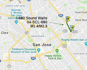 The 2018 STIP, approved at the CTC March 2018 meeting, appears to adjust the timing of PPNO 0521, SCL M1.4/M2.3, I-680 Sound Walls - Capitol Expressway to
Mueller -- In San Jose on I-680. Construct soundwalls at various locations
between Capitol Expressway and Mueller Avenue. It pushes it back to
FY20-21.
The 2018 STIP, approved at the CTC March 2018 meeting, appears to adjust the timing of PPNO 0521, SCL M1.4/M2.3, I-680 Sound Walls - Capitol Expressway to
Mueller -- In San Jose on I-680. Construct soundwalls at various locations
between Capitol Expressway and Mueller Avenue. It pushes it back to
FY20-21.
In January 2019, the CTC approved the following
allocation for a locally-administrated STIP project: $731,000. Santa Clara
Valley Transportation Authority/MTC Santa Clara 04-SCL-680 M1.4/M2.3.
I-680 Sound Walls - Capitol Expressway to Mueller. In the city of San
Jose. Construct soundwalls at various locations between Capitol Expressway
and Mueller Avenue. Contribution from other sources: $98,000. Time
extension for FY 17-18 PS&E funds expires on June 30, 2019.
(Source: January 2019 CTC Minutes, Agenda Item
2.5c.(2) Item 1)
The 2020 STIP, approved at the March 2020 CTC meeting,
continued the programming for PPNO 0521C Rt 680 Soundwalls,
Capitol-Mueller (ext 6-18), with $731K and $355K in prior years, and
$3,275K in FY20-21.
(Source: March 2020 CTC Agenda, Item 4.7, 2020 STIP
Adopted 3/25/2020)
I-680 NB HOV/Express Lanes: Route 237 (~ SCL 6.5) ⇒ Route 84 (~ ALA 12.4)
There is also a project to construct a northbound HOV lane over the Sunol Grade, Milpitas to Route 84 in Santa Clara and Alameda Counties. This was first discussed during the June 2001 CTC meeting under Agenda Item 2.1c.(1). It is TCRP Project #4, requested by the Alameda County Congestion Management Agency and authorized for $60,000,000. On June 6, 2001, the Commission designated the northbound and southbound Route 680 HOV lanes over the Sunol Grade in Alameda and Santa Clara Counties as one corridor project (STIP Amendment 00S-031). Both projects are proceeding concurrently. The northbound project is in the environmental process and the southbound project is under construction.
 In January 2015, the CTC received notice of a draft EIR
for the I-680 Northbound HOV/Express Lane Project, which will construct an
approximately 15-mile HOV/Express Lane on northbound I-680 from south of
Route 237 in Santa Clara County to north of Route 84 (Vallecitos Road)in
Alameda County. The alternatives are either build or no-build; the build
would be in multiple phases. The EIR was prepared due to a substantial
amount of public controversy surrounding the project associated with the
proposed removal of five historic trees. The routing appears to be
approximately the same segment that has the SB lanes. The project involves
addition of the HOV lane, installation of electronic tolling equipment and
signage, widening of existing paved surfaces in the median, construction
of auxiliary lanes,demolition and replacement of the Sheridan Road
overcrossing, widening the east side of the Alameda Creek Bridge,
construction of retaining walls, new andreplacement sound walls,
modification of ramp metering, and pavement rehabilitation.
In January 2015, the CTC received notice of a draft EIR
for the I-680 Northbound HOV/Express Lane Project, which will construct an
approximately 15-mile HOV/Express Lane on northbound I-680 from south of
Route 237 in Santa Clara County to north of Route 84 (Vallecitos Road)in
Alameda County. The alternatives are either build or no-build; the build
would be in multiple phases. The EIR was prepared due to a substantial
amount of public controversy surrounding the project associated with the
proposed removal of five historic trees. The routing appears to be
approximately the same segment that has the SB lanes. The project involves
addition of the HOV lane, installation of electronic tolling equipment and
signage, widening of existing paved surfaces in the median, construction
of auxiliary lanes,demolition and replacement of the Sheridan Road
overcrossing, widening the east side of the Alameda Creek Bridge,
construction of retaining walls, new andreplacement sound walls,
modification of ramp metering, and pavement rehabilitation.
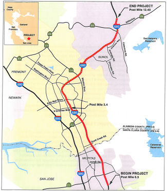
The plan is to build the HOV/express lanes in multiple phases, with the first phase being constructing the lanes from Auto Mall Parkway to Route 84 (from Post Mile 3.4 to the end of the project). It would also add an auxiliary lane between Washington Blvd and Route 238. Estimated construction costs are ~$205.789 Million for Phase 1, and $299,374 Million for the entire build.
In March 2015, it was reported that survey work has
begun for adding a fourth northbound lane between Auto Mall Parkway and
Route 84. It will be a carpool/express lane, as there is in the southbound
direction. This is moving ahead because Alameda County voters approved
funding for it in November 2014. The environmental report will be ready in
late 2015, and design work will be completed in mid-2017. Construction
will be done by 2019.
(Source: San Jose Mercury News, 3/27/2015)
 In October 2015, the CTC approved this project for future consideration of
funding: constructing a high occupancy vehicle/express lane and
rehabilitate the existing roadway on Northbound
I-680 in or near the cities of Milpitas, Fremont, and Pleasanton, and the
community of Sunol. The project is programmed in the Traffic Congestion
Relief Program and the 2014 State Highway Operation and Protection
Program. The project is not fully funded. The total estimated cost is
approximately $388,995,000 for capital and support. Depending on the
availability of funding, construction is estimated to begin in Fiscal Year
2016-17.
In October 2015, the CTC approved this project for future consideration of
funding: constructing a high occupancy vehicle/express lane and
rehabilitate the existing roadway on Northbound
I-680 in or near the cities of Milpitas, Fremont, and Pleasanton, and the
community of Sunol. The project is programmed in the Traffic Congestion
Relief Program and the 2014 State Highway Operation and Protection
Program. The project is not fully funded. The total estimated cost is
approximately $388,995,000 for capital and support. Depending on the
availability of funding, construction is estimated to begin in Fiscal Year
2016-17.
In November 2017, it was reported that the Alameda
Transportation Commission approved a $107 million contract to begin work
on adding a carpool/express lane from Auto Mall Parkway to Route 84,
widening one of the most dreaded commutes in the Bay Area. Construction
will begin in early 2018 and take two years to complete. The news was
greeted with sighs of relief from the East Bay to Silicon Valley —
as the 9-mile stretch ranks as the fourth most congested freeway in the
entire region. It also holds the dubious distinction of being the only
freeway other than the approach to the Bay Bridge to hold down the No. 1
most congested spot. That was in 1999 at the peak of the dot-com boom when
the I-680 drive through Fremont truly became a parking lot. Money for the
widening comes from two sales taxes approved by Alameda County voters. If
more funds can be found, work will begin in 2021 to extend the fourth lane
to Route 237. The project also includes upgrades to the adjacent
southbound I-680 Sunol express lane, which opened in 2010 as the first
express lane in the Bay Area.
(Source: Mercury News, 11/27/2018 (Image is from that article as well))
In April 2018, it was reported that construction of a
nine-mile carpool/express lane along a heavily congested stretch of I-680
officially kicked off in mid-April 2018. Representatives from the Alameda
County Transportation Commission, Caltrans, Alameda County Board of
Supervisors and other local officials attended a groundbreaking ceremony
for the $205 million Sunol Northbound Express Lane project. The new lane,
expected to be done by fall of 2020, will span from Auto Mall Parkway in
Fremont to north of Route 84 in Sunol, near Pleasanton. The lane will
serve double duty as a free, high-occupancy lane for carpoolers and ride
sharers as well as a speedier alternative for solo drivers who pay to use
it. County Supervisor Richard Valle, who also chairs the commission, said
the express lane will show voters that the half-cent sales tax increases
they approved in ballot measures B and BB are producing tangible results.
The state Traffic Congestion Relief Program and Highway Operations and
Protection Program meanwhile chipped in more than $57 million for the
entire project, which also includes resurfacing of all northbound lanes in
the nine-mile stretch. Construction of the new lane will primarily take
place behind cement railings off the left shoulder of the freeway, Lengyel
said, adding that Caltrans is working to minimize impact to traffic flow
during the more than two-year construction period.
(Source: East Bay Times, 4/19/2018)
In October 2020, it was reported that the fourth lane
on north I-680 through the Sunol Grade was opening as a regular carpool
lane; it will be converted to an express or toll lane sometime in 2021
when electrical work wraps up. The new lane between the Grimmer
Undercrossing and Calaveras Road is open to carpools with two or more
persons, vanpools, motorcycles, and transit vehicles. When toll lanes
arrive, you’ll need a FasTrak flex tag and three people in a vehicle
to get a free ride. In the future, there will be a two-lane off-ramp from
north I-680 to Route 84 going toward Livermore, and a continuous-access
lane from Auto Mall Parkway to Route 84, plus a new auxiliary lane between
Washington and Mission boulevards. There will be about 1,000 feet of
distance for people to get out of the new lane and move to the right if
they will be exiting to Livermore.
(Source: San Jose Mercury News, 10/28/2020)
I-680 SB HOV/Express Lanes: Route 84 (~ ALA 12.4) ⇒ Route 237 (~ SCL 6.5)
In November 2002, the first section of this project opened: a carpool lane from Washington Blvd in Fremont to Route 237 in Milpitas—a 7 mile section only in the southbound direction. The southbound interim section from Washington Blvd to Route 84 opened in December 2002. The fourth and final phase of the southbound work is currently in design with a Ready to List target of August 2007. The northbound project’s final environmental document was completed in June 2005. However, the northbound HOV project has experienced delays due to a lawsuit that was filed in response to the environmental document. In April 2006, the CTC considered a proposal to amend the scope of work to continue with design on the northbound project and utilize $58,000,000 in TCRP funds to fully fund the southbound project and provide delivery in an earlier fiscal year. The increase in scope and shift of funds was to allow time for the legal challenges of the northbound environmental document to be resolved. The revised completion dates are: Phase 1: FY 2005/2006; Phase 2: FY 2009/2010; Phase 3: FY 2009/2010; Phase 4: FY 2012/2013. In June 2008, the CTC approved an adjustment in the financial allocations.
Note that High Occupancy/Toll lanes are proposed for I-680 SB from Route 84 to Route 237. For this project the current HOV lane (opened recently) would be converted to HOT, separated from general-purpose lanes by two double yellow lines, and outfitted with transponder devices a la EZPass/FastPass. Tolls would vary depending on congestion. Carpoolers would ride free.
As of August 2009, it was noted that the toll SB HOV lane is under construction in Fremont. An additional lane was getting carved out of the Sunol Grade, and the Mission Boulevard/Route 238 overpass has been widened.
 In September 2010, HOT lanes opened at the Sunol Grade, offering solo drivers
the opportunity to buy their way into the carpool lane. Tolls will planned
to vary from less than a dollar to several dollars - with an average toll
of $3 to $5. Specific toll amounts are determined using computerized
models and the experience of existing toll bridges and roads that use the
system, known as "dynamic pricing." Carpools, buses and hybrids with the
appropriate permits will be able to use the lanes free. CHP officers will
use a combination of visual and electronic monitoring to catch cheaters,
who will face a $381 fine. Tolls are set according to information gathered
by sensors installed in the pavement that measure traffic flow, including
speed and level of congestion, in both the toll and unrestricted lanes.
Tolls rise along with congestion - and the value of a trip around the
backup. Drivers buying their way into the fast lane won't have the option
of paying cash. Express lanes require users to have a FasTrak tag in their
vehicle. Tolls will be collected electronically by a network of overhead
antennas mounted on gantries. Drivers will be able to enter the express
lane at Route 84 and at Washington Parkway and Mission Boulevard in
Fremont. Exits will be available at Auto Mall Parkway in Fremont and
Jacklin Road and Route 237 in Milpitas. The express lane will operate from
5 a.m. to 8 p.m. Monday through Friday. Outside of those hours, the lanes
will be open to all drivers. The toll lane will not be separated by a
barrier, cones or plastic stakes but by a 2-foot-wide stripe. The lanes
have specific entry and exit points. Entries will be at the start of the
lane, 1 mile south of Route 84, just past Mission Boulevard in Fremont and
just past Auto Mall Parkway. Exits will be just past Auto Mall Parkway,
just past Jacklin Road, and at the end of the lane south of Route 237.
They will be marked with signs and special striping.
In September 2010, HOT lanes opened at the Sunol Grade, offering solo drivers
the opportunity to buy their way into the carpool lane. Tolls will planned
to vary from less than a dollar to several dollars - with an average toll
of $3 to $5. Specific toll amounts are determined using computerized
models and the experience of existing toll bridges and roads that use the
system, known as "dynamic pricing." Carpools, buses and hybrids with the
appropriate permits will be able to use the lanes free. CHP officers will
use a combination of visual and electronic monitoring to catch cheaters,
who will face a $381 fine. Tolls are set according to information gathered
by sensors installed in the pavement that measure traffic flow, including
speed and level of congestion, in both the toll and unrestricted lanes.
Tolls rise along with congestion - and the value of a trip around the
backup. Drivers buying their way into the fast lane won't have the option
of paying cash. Express lanes require users to have a FasTrak tag in their
vehicle. Tolls will be collected electronically by a network of overhead
antennas mounted on gantries. Drivers will be able to enter the express
lane at Route 84 and at Washington Parkway and Mission Boulevard in
Fremont. Exits will be available at Auto Mall Parkway in Fremont and
Jacklin Road and Route 237 in Milpitas. The express lane will operate from
5 a.m. to 8 p.m. Monday through Friday. Outside of those hours, the lanes
will be open to all drivers. The toll lane will not be separated by a
barrier, cones or plastic stakes but by a 2-foot-wide stripe. The lanes
have specific entry and exit points. Entries will be at the start of the
lane, 1 mile south of Route 84, just past Mission Boulevard in Fremont and
just past Auto Mall Parkway. Exits will be just past Auto Mall Parkway,
just past Jacklin Road, and at the end of the lane south of Route 237.
They will be marked with signs and special striping.
[Source: San Francisco Chronicle, 6/24/10 and 9/13/10]
In August 2014, the CTC reprogrammed some cost savings from the Sunol Grade HOV lane construction to the southbound lane project's landscaping contract.
In September 2015, it was reported that final design
was underway for a planned express lane on northbound I-680 from Auto Mall
Parkway in Fremont up the Sunol Grade -- the opposite direction from the
adjacent express lane on southbound I-680, which celebrated its fifth
anniversary this month. Alameda CTC plans a two-phased approach to
creating an express lane along northbound I-680 between Route 84 south of
Pleasanton to Route 237 in Milpitas -- a project that also calls for
freeway widening and several auxiliary lanes connecting on- and off-ramps.
Officials just started with final design for Phase 1, the 9-mile stretch
from Auto Mall Parkway in Fremont to Route 84. The project would add an
express lane and eliminate two bottlenecks in the area that cause heavy
congestion during the evening commute. The design stage is estimated to
continue into next year, with construction to follow in 2017 and opening
in late 2018. Construction costs estimates haven't been determined, but
the overall I-680 northbound project has almost $120 million in funding
designated from Measure B, Measure BB, state and federal sources.
Officials also plan to update the I-680 southbound express lane at the
same time, making it into a near-continuous access configuration to
provide additional access opportunities to and from local interchanges.
(Source: Pleasanton Weekly, 9/25/2015)
 In August 2018, the CTC approved for future consideration
of funding the following project for which a Final Environmental Impact
Report (FEIR) has been completed: Route 84 and I-680 in Alameda County.
Construct roadway improvements including widening to a portion of Route 84
near the cities of Livermore and Pleasanton. (EA 29763) This project
proposes to widen and conform Route 84 to expressway standards between
Ruby Hill Drive and the I-680 interchange, in the vicinity of Sunol and
Pleasanton cities. The project proposes to improve interchange ramps and
extend the existing southbound I-680 High Occupancy Vehicle express lane.
A complete statutory designation as an expressway is expected for this
segment of Route 84. The proposed project is estimated to cost in total
approximately $220 million. The project is not fully funded, funding
sources are anticipated to be from local tax measures, Regional
Transportation Improvement Program funds and Alameda County. The project
is estimated to begin construction in 2021.
In August 2018, the CTC approved for future consideration
of funding the following project for which a Final Environmental Impact
Report (FEIR) has been completed: Route 84 and I-680 in Alameda County.
Construct roadway improvements including widening to a portion of Route 84
near the cities of Livermore and Pleasanton. (EA 29763) This project
proposes to widen and conform Route 84 to expressway standards between
Ruby Hill Drive and the I-680 interchange, in the vicinity of Sunol and
Pleasanton cities. The project proposes to improve interchange ramps and
extend the existing southbound I-680 High Occupancy Vehicle express lane.
A complete statutory designation as an expressway is expected for this
segment of Route 84. The proposed project is estimated to cost in total
approximately $220 million. The project is not fully funded, funding
sources are anticipated to be from local tax measures, Regional
Transportation Improvement Program funds and Alameda County. The project
is estimated to begin construction in 2021.
(Source: August 2018 CTC Agenda Item 2.2c.(10))
In December 2020, it was reported that the CTC approved
$25 million to complete the I-680 Southbound Express Lanes project in
Alameda County.
(Source: The Bay Link, 12/3/2020)
In June 2016, the CTC approved for future consideration of funding a project in Alameda County that will rehabilitate the roadway mainline and on/off-ramps on a portion of I-680 (04-Ala-680 PM 0.0/4.0, roughly Scott Creek Road to Auto Mall Parkway) in the city of Fremont. The project is programmed in the 2016 State Highway Operation and Protection Program. The total programmed amount is $22,360,000 for capital and support. Construction is estimated to begin in Fiscal Year 2017-18. The scope, as described for the preferred alternative, is consistent with the project scope programmed by the Commission in the 2016 State Highway Operation and Protection Program. A copy of the MND has been provided to Commission staff. The project will result in less than significant impacts to the environment after mitigation. The following resource area may be impacted by the project: biological resources. Avoidance and minimization measures will reduce any potential effects on the environment. These measures include, but are not limited to, grassland and freshwater marsh habitat for the California red-legged frog and California salamander will be restored both on and off site. As a result, an MND was completed for this project.
Ramp Metering System (04-Ala-680, PM 0.0/21.9)
In January 2017, the CTC approved for future consideration of funding a project that will install ramp metering system for sixteen on-ramps/connectors along I-680 in Alameda County from Scott Creek Road Undercrossing in the City of Fremont to the Alcosta Boulevard Overcrossing in the City of Dublin 04-Ala-680, PM 0.0/21.9. These onramps connectors will be widened to provide for High Occupancy Vehicles (HOV) preferential lanes and/or additional mixed flow lanes. The project is programmed in the 2016 State Highway Operation Program for $27,753,000 in Construction (capital and support) and Right of Way (capital and support). Construction is estimated to begin in Fiscal Year 2018-19. The scope, as described for the preferred alternative, is consistent with the project scope programmed by the Commission in the 2016 State Highway Operation and Protection Program.
In August 2017, the CTC added the following to the SHOPP: 04-Ala-680 M0.0/R21.9 I-680: In and near Fremont, Pleasanton, and Dublin, from 0.3 mile south of Scott Creek Road to 0.3 mile north of Alcosta Boulevard. Install ramp meters, ramp HOV bypass lanes, and traffic operations systems (TOS). $800K (R/W) $28,300K (C) $11,300K (Support) PA&ED: 11/16/2016 R/W: 07/16/2018 RTL: 08/01/2018 BC: 03/04/2019
The CTC is funding a study for a cross connector freeway (Route 262) between I-680 and I-880 near Warm Springs (~ ALA M2.202).
In July 2010, Caltrans removed a flag mural that had been painted on a concrete slab near the Sunol Grade (~ ALA R8.846) after the terrorist attacks on Sept. 11, 2001. Caltrans said it removed the mural, which was visible to passing motorists, after it belatedly discovered it was on state-owned land. Gov. Schwarzenegger said that it was "unconscionable" to remove the flag mural only a few days before the Fourth of July. The controversy grew. Caltrans then met with East Bay residents R.J. Waldron, Eric Noda and Thomas Hanley, who painted the mural in 2001, "to discuss a suitable location" for a flag mural. Meanwhile two other men repainted the flag mural without contacting Caltrans so it would be in place for the Fourth of July.
Route 84/I-680 Interchange Improvements: 4–ALA–680 (ALA 10.3/15.3)
The 2018 STIP, approved at the CTC March 2018 meeting, appears to modify this. It includes $11,114K funding in FY19-20 for PPNO 0080D, Widen, s/o Ruby Hill-Rt 680, Rt 84/680 IC Imprvs(TCEP). This is the "SR-84 Widening and SR-84/I-680 Interchange Improvements Project". This project proposes to proposes to conform Route 84 to expressway standards between south of Ruby Hill Drive and the I-680 interchange in southern Alameda County (4–ALA–84 (PM 17.9/22.9), 4–ALA–680 (PM 10.3/15.3)) by: (•) Widening Route 84 to accommodate one additional lane in each direction; (•) Implementing additional improvements to reduce weaving/merging conflicts and help address the additional traffic demand between I-680 and Route 84. The project would also improve the SR-84/I-680 interchange operations by: (•) Modifying ramps; and (•) Extending the existing southbound I-680 High Occupancy Vehicle/Express Lane northward by ~2 miles. Currently, the southbound express lanes extend from Route 84 south of Pleasanton to Route 237 in Milpitas. The amount of funding in the 2018 STIP agrees with the amount that the Alameda County Transportion Commission (ACTC) requested in regional improvement funding; it combines with $122,000K in Measure BB funding, $1,046K in Measure B funding, $14,940K in local (Tri-Valley Transportation Council) funding. ACTC has requested an additional $70,900K in SB1 funding for this. Currently, construction is scheduled for Winter 2021 - Winter 2023.
Note that most of the information on this project is
with Route 84. With respect to southbound I-680, the project would extend
the existing HOV/express lane northward from its current entry point at
approximately Calaveras Road to approximately 0.8 mile north of Koopman
Road, a distance of approximately 2 miles. The pavement in the center
median of southbound I-680 would be widened to accommodate the HOV/express
lane. Approximately six overhead signs (including variable toll message
signs [VTMS] with pricing information) and toll readers for FasTrak
transponders would be installed in the median of I-680. The northernmost
overhead sign would be approximately 1.8 miles north of Koopman Road (at
4-Ala-680 PM 14.2). Proposed project activities between the northernmost
overhead sign and the I-680/Sunol Boulevard interchange would be limited
to the placement of temporary construction signage.
(Source: August 2017 Draft EIR)
In July 2023, it was reported that MTC’s
Programming and Allocations Committee recommended allocations of Regional
Measure 3 toll dollars for this project. The committee's recommendation
will be considered by the full Commission at its July 26 2023 meeting. The
specific allocation was: Alameda County Transportation Commission: $85
million for the I-680/Route 84 Interchange Reconstruction Project.
(Project underway, completion expected early 2025.)
(Source: MTG/ABAG Bay Link Blog, 7/12/2023)
Express Lanes: Route 84 to Alcosta Boulevard project (PPNO 2905F) (04-Ala-680, PM R10.6/R21.9; 04-CC-680, PM R0.0/1.1)
 In January 2021, the CTC approved for future consideration of funding
04-Ala-680, PM R10.6/R21.9; 04-CC-680, PM R0.0/1.1. Interstate 680
Express Lanes from State Route 84 to Alcosta Boulevard Project.
Construct High Occupancy Vehicle/express lanes on I-680 in Alameda and
Contra Costa Counties. (MND) (EA 0Q300) (Local Funds). The project is
located along approximately nine miles of I-680 in Alameda and Contra
Costa Counties near the cities of near Pleasanton, Dublin, and San Ramon,
and the community of Sunol. The Department, in cooperation with the
Alameda County Transportation Commission (Alameda CTC), proposes to
construct High Occupancy Vehicle/express lanes (HOV/express lanes) on
northbound and southbound I-680 from Route 84 (Vallecitos Road) in Alameda
County to north of Alcosta Boulevard in Contra Costa County. This project
is not fully funded. The project is estimated to cost $480 million
with $30 million currently programmed from the Alameda County local tax
measures. Additional funding is anticipated to come from additional
local tax measure, Senate Bill 1 programs, Regional Measure 1, and the
State Transportation Improvement Program (STIP). The project is
expected to be constructed in phases with a construction start estimated
in 2024-25. A Mitigated Negative Declaration (MND) has been
completed. The project will result in less than significant impacts
to the environment after mitigation. The following resource areas
may be impacted by the project: biological resources. Avoidance and
minimization measures will reduce any potential effects on the
environment. These measures include, but are not limited to,
pre-construction surveys for special-status wildlife species and
monitoring during construction.
In January 2021, the CTC approved for future consideration of funding
04-Ala-680, PM R10.6/R21.9; 04-CC-680, PM R0.0/1.1. Interstate 680
Express Lanes from State Route 84 to Alcosta Boulevard Project.
Construct High Occupancy Vehicle/express lanes on I-680 in Alameda and
Contra Costa Counties. (MND) (EA 0Q300) (Local Funds). The project is
located along approximately nine miles of I-680 in Alameda and Contra
Costa Counties near the cities of near Pleasanton, Dublin, and San Ramon,
and the community of Sunol. The Department, in cooperation with the
Alameda County Transportation Commission (Alameda CTC), proposes to
construct High Occupancy Vehicle/express lanes (HOV/express lanes) on
northbound and southbound I-680 from Route 84 (Vallecitos Road) in Alameda
County to north of Alcosta Boulevard in Contra Costa County. This project
is not fully funded. The project is estimated to cost $480 million
with $30 million currently programmed from the Alameda County local tax
measures. Additional funding is anticipated to come from additional
local tax measure, Senate Bill 1 programs, Regional Measure 1, and the
State Transportation Improvement Program (STIP). The project is
expected to be constructed in phases with a construction start estimated
in 2024-25. A Mitigated Negative Declaration (MND) has been
completed. The project will result in less than significant impacts
to the environment after mitigation. The following resource areas
may be impacted by the project: biological resources. Avoidance and
minimization measures will reduce any potential effects on the
environment. These measures include, but are not limited to,
pre-construction surveys for special-status wildlife species and
monitoring during construction.
(Source: January 2021 CTC Agenda, Agenda Item
2.2c.(1))
In May 2021, the CTC received notice that the Alameda
County Transportation Commission (ACTC) proposes to program $40,000,000
from future Alameda County Regional Improvement Program (RIP) shares to
construction (CON) phase for the I-680 Southbound Express Lane, from Route 84 to Alcosta Boulevard project (PPNO 2905F) in Alameda and Contra Costa
Counties (04-ALA-680 R10.600 to 04-CC-680 ~ R0.009). The I-680 Southbound
Express Lane from Route 84 to Alcosta Boulevard project will add one High
Occupancy (HOV)/express lane and construct other improvements including
replacement/upgrade of median concrete barrier and electronic toll system
elements on I-680 in the southbound direction, between Route 84 and
Alcosta Boulevard. As part of the Senate Bill 1 Local Partnership Program
(LPP) (SB1) Cycle 2 adoption of new projects, the Commission programmed
$25,000,000 LPP-Competitive) funds in Fiscal Year 2021-22 to the CON phase
of this project. The complete funding plan for construction relied
on ACTC requesting $40,000,000 in STIP funds from Alameda County future
RIP shares and $12,000,000 in Local Partnership Program (LPP-Formulaic)
funds. Therefore, ACTC is requesting to program $40,000,000 in RIP funds
from future County shares to CON phase. To fully-fund the CON phase,
ACTC will be submitting an application to program $12,000,000
LPP-Formulaic funds to CON phase of this project at a future Commission
meeting. To better align the delivery of this project with a State
Highway Operation and Protection Program project within the same project
limits. ACTC is requesting that these funds be programmed in
2021-22.
(Source: May 2021 CTC Agenda, Agenda Item 2.1b.(3))
In June 2021, the CTC approved a request from the
Alameda County Transportation Commission to program $5,274,000 in Regional
Improvement Program shares of Alameda County to Construction phase for the
I-680 Southbound Express Lane from Route 84 to Alcosta Boulevard project,
in Alameda and Contra Costa Counties. (04-ALA-680 R10.600/R21.900 PPNO
2905F). Concurrent with this amendment request, the CTC approved
$5,792,000 in the COVID Relief Funds to the construction phase of this
project via a STIP amendment. The remaining construction funding
short fall will be covered by a combination of Bay Area Toll
Authority’s (BATA) LLP-Formulaic funds ($10,000,000) and rest with
local funds. To better align the delivery of this project with a
SHOPP project within the same project limits, ACTC is requested that the
RIP funds be programmed in 2021-22. At a future meeting, the
Commission will be programming LPP-Formulaic funds from both Alameda
County and BATA shares to the construction phase. The highway construction
and tolling system development and implementation contracts are of very
different nature in their scope of work. The highway construction is a
civil works contract while the tolling contract is primarily an
Information Technology (IT) type of work. Each contract will have
different implementing agency and its own scope, schedule, and cost. For
an efficient delivery of the overall project, ACTC proposed to split the
overall scope of work into two separate contracts:
(Source: June 2021 CTC Agenda, Agenda Item
2.1a.(5); June 2021 CTC Agenda, Agenda Item 2.1a.(19); June 2021 CTC
Agenda, Agenda Item 4.18)
Also in June 2021, the CTC approved a request from the
Alameda County Transportation Commission and the Bay Area Toll Authority
to add the I-680 Southbound Express Lane from Route 84 to Alcosta
Boulevard Project in Alameda County to the LLP-Formulaic fund
allocation. The Alameda County Transportation Commission requested to
program their available 2020 formulaic funding for construction as
follows: $8,006,000 in Fiscal Year 2021-22 and $4,003,000 in Fiscal Year
2022-23. The Bay Area Toll Authority requests to program $10,000,000 of
their available 2020 formulaic funding for construction in Fiscal Year
2021-22. This project will close the nine-mile gap between the High
Occupancy Vehicle/express lanes on southbound Interstate 680 between
approximately State Route 84 in Sunol and Alcosta Boulevard in San Ramon.
This project will construct High Occupancy Vehicle lanes, widen pavement
in the median and shoulders, construct retaining walls and sound walls and
upgrade safety features throughout the corridor; and in a separate
segment, install electronic tolling equipment and signage. The anticipated
benefits of this project include congestion relief, improved travel time
reliability, and improved safety.
(Source: June 2021 CTC Agenda, Agenda Item 4.16)
In December 2021, the CTC approved the following
State-Administered multi-funded STIP/LPP (Formulaic and Competitive)
allocation: $52,918,000. 04-Ala-680 R10.6/R21.9. PPNO 04-2905F; ProjID
0418000069; EA 0Q300. Interstate 680 Southbound Express Lane from
Route 84 to Alcosta Blvd. I-680 From Route 84 (Alameda County) to
Alcosta Boulevard (Contra Costa County). Project will add one High
Occupancy (HOV)/express Lane and construct other improvements including
replacement/upgrade of median concrete barrier, and lighting on Interstate 680 in the southbound direction between Route and Alcosta Boulevard
through Alameda and Contra Costa Counties. A minor design change (lane
width and shoulder width reduction) through a design standard decision
document has been approved by Caltrans for this project. The Interstate 680 Southbound Express Lane Planting Mitigation Landscape project (PPNO
04-2905L) will be split off, all phases will be funded by local funds.
(Related SHOPP allocation for EA 0J624/PPNO 04-2905J under Resolution
FP-21-36; December 2021.) (EA 0Q300/PPNO 04-2905F combined with SHOPP EA
0J624/PPNO 04-2905J for construction under EA 0Q30U/Project ID
0420000235.) (Future consideration of funding approved under
Resolution E-21-05; January 2021.)
(Source: December 2021 CTC Agenda, Agenda Item
2.5s.(9)/2.5v.(1))
In December 2022, the CTC approved for future
consideration of funding the following project for which a MND and an
Addendum have been completed: I-680 in Alameda and Contra Costa Counties
(04-Ala-680, PM R10.6/R21.9, 04-CC-680, PM R0.0/1.1). Construct High
Occupancy Vehicle lanes on northbound and southbound I-680, in Alameda and
Contra Costa Counties. (PPNO 04-2905F). The project is located on I-680 at
post mile R10.6 and R21.9, in Alameda County, and post mile R0.0 and 1.1,
in Contra Costa County. The Department, in cooperation with the Alameda
County Transportation Commission (Alameda CTC), proposes to construct High
Occupancy Vehicle/express lanes (HOV/express lanes) on northbound and
southbound I-680 from Route 84 (Vallecitos Road) in Alameda County to
north of Alcosta Boulevard in Contra Costa County. This project is not
fully funded. The project is currently funded in the 2020 State
Transportation Improvement Program (STIP) for a total of $217,846,000,
which includes Construction (capital and support). Construction is
expected to begin in 2024-25. The scope, as described for the preferred
alternative, is consistent with the project scope programmed by the
Commission in the 2020 STIP.A MND was prepared because of potential
biological resource impacts. A copy of the MND has been provided to
Commission staff. The Commission approved the project for future
consideration of funding on January 28, 2021, under Resolution E-21-05.
During the design phase it was determined that a Section 1602 Lake and
Streambed Alteration Agreement from the California Department of Fish and
Wildlife (CDFW) would not be necessary. The Department subsequently
completed an Addendum to the MND pursuant to the California Environmental
Quality Act. The Department has approved this project for construction.
This approval and the Addendum satisfy the environmental requirements for
this stage of the planning process.
(Source: December 2022 CTC Agenda, Agenda Item
2.2c.(8))
In July 2023, it was reported that MTC’s
Programming and Allocations Committee recommended allocations of Regional
Measure 3 toll dollars for this project. The committee's recommendation
will be considered by the full Commission at its July 26 2023 meeting. The
specific allocation was: Alameda County Transportation Commission: $80
million for the I-680 Southbound Express Lane from Alcosta Boulevard to
Route 84. (Project underway, completion expected late 2025.)
(Source: MTG/ABAG Bay Link Blog, 7/12/2023)
In January 2013, the CTC authorized relinquishment of right of way along Route 680 at St. Patrick Way (~ ALA R20.344), in the city of Dublin, consisting of collateral facilities.
Pleasanton Express Lanes (SB: ~ ALA R21.858 to CC R12.636; NB: to CC R11.297)
 In February 2013, it was reported that Caltrans plans to convert HOV lanes on I-680 into HOT
("Express" or High Occupancy/Toll) lanes -- specifically, I-680 southbound
from the Benicia-Martinez Bridge to I-580 and northbound from I-580 to
south of Walnut Creek as well as a stretch from Concord to the
Benicia-Martinez Bridge. Express lanes work by continuing to allow
carpoolers free access to the fast lane but then selling unused capacity
to drivers who wouldn't normally qualify to drive in them. Tolls are
collected electronically using FasTrak transponders, and electronic
systems are used to monitor traffic and set tolls at a rate designed to
keep traffic in the lanes flowing at 50 mph or faster. As the lanes get
more congested, tolls rise, and as gridlock eases, they drop. Toll rates
for the network have not been set yet, but on the existing lanes they have
varied from a 30-cent minimum to about $5 or $6.
In February 2013, it was reported that Caltrans plans to convert HOV lanes on I-680 into HOT
("Express" or High Occupancy/Toll) lanes -- specifically, I-680 southbound
from the Benicia-Martinez Bridge to I-580 and northbound from I-580 to
south of Walnut Creek as well as a stretch from Concord to the
Benicia-Martinez Bridge. Express lanes work by continuing to allow
carpoolers free access to the fast lane but then selling unused capacity
to drivers who wouldn't normally qualify to drive in them. Tolls are
collected electronically using FasTrak transponders, and electronic
systems are used to monitor traffic and set tolls at a rate designed to
keep traffic in the lanes flowing at 50 mph or faster. As the lanes get
more congested, tolls rise, and as gridlock eases, they drop. Toll rates
for the network have not been set yet, but on the existing lanes they have
varied from a 30-cent minimum to about $5 or $6.
In March 2014, it was reported that the first toll
lanes in Contra Costa County are expected to open on I-680 by mid-2016.
The $45 million project, which is in the design stage, will create 23
miles of FasTrak express lanes that solo drivers can pay to use -- as long
as its traffic is moving at least 45 mph. Construction should begin at the
start of 2015. The system would use the same FasTrak technology used on
Bay Area bridges, with electronic toll tags that charge fees but require
no stopping at toll booths. The toll lanes -- which will be free for
carpoolers, motorcycles and electric vehicles -- will run on southbound
I-680 from Rudgear Road in Walnut Creek to Alcosta Boulevard in San Ramon,
and on northbound I-680 from Alcosta to Livorna Road in Alamo. The I-680
project is proceeding quickly because it is relatively inexpensive, with
no need to build new lanes. Instead, existing HOV lanes would be converted
with the installation of FasTrak toll tag readers, signs,
traffic-monitoring video cameras, and observation areas for the California
Highway Patrol to monitor lanes.
(Source: Contra Costa Times)
In August 2015, it was reported that the project to
bring toll express lanes to I-680 through the San Ramon Valley is expected
to start construction in August 2015, with completion estimated for late
2016.The MTC aims to convert existing high-occupancy vehicle (HOV) lanes
on I-680 between Alcosta Boulevard in San Ramon and Rudgear Road in
southern Walnut Creek into express lanes that would charge tolls for
access during peak commute times. The project does not include freeway
widening.As proposed, the congestion-relief project would replace existing
HOV lanes with express lanes on southbound I-680 from Rudgear Road to
Alcosta Boulevard and on northbound I-680 from Alcosta to Livorna Road in
Alamo -- approximately 23 miles overall. The express lanes would be free
to access for carpools, vanpools, public transit, motorcycles and eligible
clean-air vehicles while other solo drivers could pay a toll to use the
lanes. Toll lane hours and rates have not been finalized. Work by DeSilva
Gates is set to include adding signage, overhead toll readers, camera
equipment and polls, median barriers, roadside lighting and associated
roadwork such as striping and paving. A total of 31 overhead sign
structures are planned for medians through the I-680 corridor. The
contract awarded to DeSilva Gates on June 24 is worth about $16.3 million
for construction, plus almost $2.2 million in contingency funding. There
are three express-lane segments that in time will extend from the Benicia
Bridge to the county border at Alcosta Boulevard in San Ramon. The first
segment is on both directions of I-680 from Walnut Creek to San Ramon. The
first stage of the installation is preparing the highway for installation
of fiber optic cables that will carry information to overhead signs that
alert drivers to the tolls.
(Source: Pleasanton Weekly, 8/7/2015, ContraCosta
Times, 8/12/2015)
In September 2015, it was reported that roadwork signs
and equipment have arrived to start on new express lanes along I-680 north
of Pleasanton. The MTC-led project plans to convert existing HOV lanes
from Alcosta Boulevard in San Ramon to Rudgear Road in Walnut Creek
(southbound) and Livorna Road in Alamo (northbound), covering a distance
of 23 miles. No freeway widening will occur. Construction is expected to
last until late 2016. The overall project cost is currently estimated at
$49 million, with about half going toward construction. Toll lane hours
and rates have not been finalized, but MTC expects to adopt a toll
ordinance next June, laying the groundwork for future approval of a
dynamic-pricing toll structure. As for I-680 north plans, the San
Ramon-Walnut Creek segment is the first of three proposed MTC projects
aimed at creating express lanes most of the way from Alcosta to the
Benicia-Martinez Bridge.
(Source: Pleasanton Weekly, 9/25/2015)
In July 2017, it was reported that the Express Lanes on
the I-680 just north of Pleasanton are nearing completion, scheduled to
open in early fall 2017, though a hard date has not yet been specified.
The project converting carpool lanes into toll express lanes is intended
to promote carpooling and improve traffic congestion on the I-680
corridor, Metropolitan Transportation Commission (MTC) project manager
Barbara Laurenson said at the San Ramon City Council meeting.The $45
million project involves converting high-occupancy vehicle (HOV) lanes
into toll express lanes. Project construction, which began in August 2015
and was initially expected to be completed in late 2016, is now scheduled
to be completed by late September or early October 2017. Everyone can
drive in the lanes, but only HOV and some select others can use them for
free during toll hours -- similar to the express lanes on I-580 through
the Tri-Valley and I-680 south of Pleasanton. In order to use the express
lanes, drivers will need to obtain a toll tag -- toll-exempt vehicles must
use a FasTrak Flex toll tag, set in the "2" position for 2-person carpools
and the "3+" position for everything else, while solo drivers can have
either a standard FasTrak toll tag or a FasTrak Flex tag set in the "1"
position. Solo drivers will be charged a toll fee to use the lanes, while
carpools, vanpools, eligible clean-air vehicles, motorcycles and buses can
use the lanes toll-free. The lanes will operate from 5 a.m. to 8 p.m.
weekdays and will be managed and monitored by MTC.
(Source: Pleasanton Weekly, 7/14/2017)
In October 2017, it was reported that, after over two
years of construction, the opening date for San Ramon Valley's I-680
express lanes are officially scheduled to open Oct. 9. The $56 million
project has involved converting the single high-occupancy vehicle (HOV)
lane in each direction into a toll express lane as a tool to help reduce
congestion. It includes one northbound express lane from Alcosta Boulevard
in San Ramon to Livorna Road in Alamo, and one southbound express lane
from Rudgear Road in Walnut Creek to Alcosta Boulevard. Everyone will be
able to drive in the lanes, but only HOVs and select others can use them
for free during toll hours: carpools, vanpools, eligible clean-air
vehicles, motorcycles and buses all count as HOV for tolling purposes. All
vehicles will need a toll tag. Toll-exempt vehicles can set the FasTrak
Flex toll tag in the "2" position for two-person carpools and the "3+"
position for all other carpools, while solo drivers can use either a
standard FasTrak toll tag or a FasTrak Flex tag set in the "1" position.
(Source: Danville/San Ramon Press, 10/9/2017)
San Ramon / Danville Auxilliary Lanes (~ CC R2.887 to CC R4.204)
There are plans to add NB and SB auxilliary lanes on Route 680 in San Ramon from Bollinger Canyon Road to Crow Canyon Road and in Danville from Sycamore Valley Road to Diablo Road. September 2005 CTC Agenda.
In December 2011, it was reported that Contra Costa County transit officials and Caltrans are exploring rebuilding the Norris Canyon Overpass to include new onramps and offramps tied directly to carpool lanes, with use restricted to buses and carpools. Neighbors near Norris Canyon Road, however, say it would worsen local traffic and make it unsafe for children to walk or bike across a freeway overpass.
In August 2012, the CTC approved $18,910 for I-680 Auxiliary Lanes - Segment 2. In the Cities of Danville and San Ramon. Construct auxiliary lanes in two both directions, between Sycamore Valley Road in Danville and Crow Canyon Road in San Ramon.
In March 2013, it was reported that construction was
about to being on the auxiliary lane project between Sycamore Valley Road
in Danville and Crow Canyon Road in San Ramon. Construction actually began
in April 2013. The construction contract permits the project to be
finished in mid-2014. The contractors -- a joint venture of Bay Cities
Paving & Grading and Inc/Myers J.V. — are pushing for an earlier
completion if dry weather allows. Half or $16 million of the cost is paid
for with funds from Contra Costa County's voter-approved half cent sales
tax for transportation. Another $9.2 million comes from developer fees
collected in the Tri-Valley region. Another $4.2 million comes from state
and federal grants.
(Source: Contra Costa Times, 4/8/13)
In March 2013, it was reported that there were going to be community meetings on the HOV ramp project in San Ramon. The ramps were originally proposed for the Norris Canyon overpass, but were vigorously opposed by neighbors at public meetings last year. Neighbors said the ramps would negatively affect their quality of life by increasing traffic and noise. Others claimed the ramps would affect safety by increasing the number of buses and trucks on Norris Canyon Road, where children ride bikes to school. After these protests, Caltrans indicated they would reconsider an option for an HOV ramp at nearby Executive Parkway, previously considered a less suitable location.
In August 2013, the CTC received notice of preparation of an EIR for a proposed project in Contra Costa County that would construct High Occupancy Vehicle on- and off-ramps and auxiliary lanes on I-680 between Bollinger Canyon Road and Crow Canyon Road in the city of San Ramon. The project is not fully funded. The project is funded through the environmental phase with local funds. Funds for construction may be requested from the Commission in the future. The total estimated cost is $102,000,000 for capital and support. Depending on the availability of funds, construction is estimated to begin in Fiscal Year 2017-18. Three alternatives are being considered:
From Walnut Creek to I-780 near Benecia
I-680 Southbound HOV Lane Gap Closure Project / Walnut Creek (SB: ~ CC 11.2 to CC 16.6)
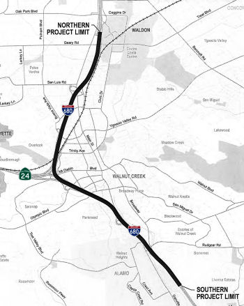 In December 2014, the CTC approved for future consideration of funding a project in Contra
Costa County that will construct a 5.4 mile long HOV Lane on a portion of
I-680 in the city of Walnut Creek. The project is programmed in the 2014
State Transportation Improvement Program. The total estimated cost is
$84,657,000 for capital and support. Construction is estimated to begin in
Fiscal Year 2016-17. The scope, as described for the preferred
alternative, is consistent with the project scope programmed by the
Commission in the 2014 State Transportation Improvement Program.
In December 2014, the CTC approved for future consideration of funding a project in Contra
Costa County that will construct a 5.4 mile long HOV Lane on a portion of
I-680 in the city of Walnut Creek. The project is programmed in the 2014
State Transportation Improvement Program. The total estimated cost is
$84,657,000 for capital and support. Construction is estimated to begin in
Fiscal Year 2016-17. The scope, as described for the preferred
alternative, is consistent with the project scope programmed by the
Commission in the 2014 State Transportation Improvement Program.
In December 2017, the CTC amended the HOV lane closure
project as follows: The I-680 Southbound HOV Lane Gap Closure project will
construct HOV lanes from Livorna Road to 0.2 miles north of Geary Road. It
is the highest priority project for the region and was originally
programmed in FY 2017-18, however the STIP funding was delayed as part of
the 2016 STIP to FY 2019-20. The current schedule is to begin construction
in FY 2017-18. The project has been delivered with all constraints cleared
and is on schedule to be advertised in February 2018 and awarded no later
than May 2018. The project however, is being revised to convert the HOV
lanes to HOT express lanes and to combine this project with the adjacent
I-680 North Express Lane project to the north, for construction. The I-680
North Express Lane project converts the existing southbound HOV lane into
an express lane from Marina Vista Avenue to Rudgear Road. An adjacent
project to the south, converting the southbound HOV lane to an express
lane from Rudgear Road to Alcosta Boulevard, was completed and open to
traffic in October 2017. With the construction of this project, I-680 will
have a continuous southbound express lane from the city of Martinez to the
Alameda County line. The local funds being used in leiu of STIP funds are
committed or programmed to other projects and programs within CCTA’s
approved Measure J Expenditure Plan. The STIP funds will ultimately be
needed for CCTA to meet its commitments on these projects and programs and
will be requested per the AB 3090 reimburesement agreement at a future
time specified below.
(Source: December 2017 CTC Agenda Item 2.1b.(2))
The 2018 STIP, approved at the CTC March 2018 meeting, appears to adjust the funding for PPNO 0222E: In Walnut Creek. Construct a HOV lane on southbound I-680, from Livorna Road to 0.2 miles north of Geary Road. Specifically, it transfers $15,557K from construction of N. Main (~ CC 15.6) to Livorna Road in FY19-20 to the Livorna Road to Geary Road in FY18-19.
In October 2018, it was reported that transportation
officials in Contra Costa County held a groundbreaking ceremony on a $127
million project that will add 11 miles of a southbound carpool express
lane from Martinez to Walnut Creek, shortening drive times along I-680 by
10 to 15 minutes. When completed in 2021, the new carpool lane will
connect to the existing express lane that runs from Walnut Creek to San
Ramon, accommodating more than 500 additional cars per hour along I-680 in
what is one of the Bay Area's worst commutes. To complete the project,
Caltrans has partnered with the Contra Costa Transportation Authority, the
Metropolitan Transportation Commission and the Federal Highway
Administration. According to MTC spokesman John Goodwin, the estimated
project cost of $127 million includes $55 million for converting the
existing carpool lane from Martinez to Walnut Creek, $60 million for
widening southbound I-680 through Walnut Creek, and $12 million for
"system integration," or tying the new infrastructure into the existing
carpool lane from Rudgear Road to the Alameda County line. Funding sources
include $51.3 million from the Bay Area Toll Authority, $36.9 million from
Contra Costa County's Measure J sales tax, $19.4 million from Regional
Measure 2 toll funds and $15.6 million from the Contra Costa
Transportation Authority's State Transportation Improvement Program. An
additional $3.8 million is expected to by covered by other MTC funding.
(Source: SF Gate, 10/3/2018)
In June 2019, the CTC approved an allocation of
$2,286,000 for the locally-administered Local Partnership Program (LPP)
(Formulaic) Innovate 680: I 680-Northbound HOT/HOV Project (PPNO 2321B)
(04-CC-680 R11.1/23.0) (PPNO 04-2321B ProjID 0418000070). I-680 in Contra
Costa County. Widen northbound I-680 to add an Express Lane, between
Livorna Road and Route 242 and covert the existing HOV lane to an Express
Lane, between Route 242 and Marina Vista.
(Source: June 2019 CTC Minutes, Agenda Item
2.5s.(5))
On March 16, 2022, the CTC approved the 2022 State
Transportation Improvement Program, which included the following project:
PPNO 2321B "Rt680 NB Express Lanes Completion Ph 1", Total: $15,000,000
programmed in FY26-27.
(Source: "2022 State Transportation Improvement
Program", Adopted March 16, 2022)
I-680 Southbound Express Lane Project (~ CC R12.646 to CC 16.387)
In August 2020, it was reported that the final
southbound stretch of the almost 25-mile I-680 expressway/carpool lane
from Martinez to San Ramon — the longest in the Bay Area — was
opening a year ahead of schedule. Workers have finished the final gap, a
four-mile segment from Treat Boulevard to Rudgear Road in Walnut Creek,
which is part of a larger project that spans from Marina Vista Avenue in
Martinez south to Rudgear Road in Walnut Creek. The new stretch,
totaling 11 miles, will operate as an HOV or carpool lane for clean-air
vehicles and cars occupied by at least two people from 5 a.m. to 8 p.m.
weekdays. Once workers complete installing and testing toll equipment
early in 2021, the new segment will become part of the existing expressway
that extends from Rudgear Road in Walnut Creek to Alcosta Boulevard in San
Ramon. Carpools will still be able to use the express lane free of charge
with a FasTrak Flex toll tag, while solo drivers will be charged to use
it, according to officials of the Metropolitan Transportation Commission,
which operates and manages the expressway. The new segment is the last
part of the $110 million I-680 Southbound Express Lane Project that Contra
Costa Transportation Authority began building in 2018. The project
stretches 11 miles from Martinez to Walnut Creek and connects with the
already completed 12-mile expressway to San Ramon. Future plans call for
the extension of northbound express lanes of the I-680 corridor from
Walnut Creek to Martinez, but funding has yet to be secured for that. When
the final northbound express/HOV lanes are completed, commuters wanting to
connect to Route 4 and East Contra Costa will be able to continue north on
I-680, joining an HOV lane two miles earlier than had they stayed on Route 242.
(Source: $$ Mercury News, 8/21/2020)
In July 2021, it was reported that the Metropolitan
Transportation Commission on Tuesday announced that the express lane along
an 11-mile stretch of southbound I-680 from Martinez through Walnut Creek
will begin charging tolls in August 2021. The tolling operations will
begin at 5 a.m. on Aug. 20 and will connect with the existing 11-mile
express lane from Rudgear Road in Walnut Creek to Alcosta Boulevard in San
Ramon, according to the MTC.
(Source: Bay City News/Patch, 7/21/2021)
In August 2012, the CTC relinquished right of way in the city of Walnut Creek along Route 680 between Lancaster Road and San Luis Road (~ CC 13.152 to CC 15.708), consisting of collateral and nonmotorized transportation facilities.
In June 2020, the CTC authorized relinquishment of right of way,
consisting of collateral facilities, in the County of Contra Costa along
Route 680 at Circle Drive (04-CC-680-PM 13.6).
(Source: June 2020 CTC Minutes, Agenda Item 2.3c)
In January 2008, the CTC relinquished right of way in the city of Walnut Creek, at North Main Street (~ CC 15.6) , from approximately 250 feet south of Sun Valley Drive to the Walnut Creek/Pleasant Hill city limit line, consisting of reconstructed city streets.
In 2007, the CTC considered a request for $10.5M from the Corridor Mobility Improvement Account (CMIA) to extend the NB HOV from North Main St. to Route 242 (~ CC 15.633 to CC R18.572) in Contra Costa County, but didn't recommend it for funding.
In June 2021, the CTC amended the following project into the 2020 SHOPP:
04-Ala-80 5.9/6.4; 04-CC-680 16.9/17.1. PPNO 1489A ProjID 0415000110 EA
04-3J260. I-80 In Berkeley, from University Avenue to west of Gilman
Street; also on I-680 in Contra Costa County, in Pleasant Hill on Route 680 from Oak Park Boulevard to 0.2 mile north of Oak Park Boulevard (PM
16.9/17.1). Construct outer separation concrete barriers between
freeway and frontage roads.PA&ED $790K; PS&E $1,434K; R/W Sup
$64K; Con Sup $1,396K; R/W Cap $70K; Const Cap $8,398K TOTAL $12,152K.
Begin Const: 6/15/2024. Also in June 2021, the CTC approved the following
pre-construction allocation: 04-Ala-80 5.9/6.4; 04-CC-680 16.9/17.1. PPNO
1489A; ProjID 0415000110; EA 3J260. I-80 In Berkeley, from University
Avenue to west of Gilman Street; also in Contra Costa County, in Pleasant
Hill on Route 680 from Oak Park Boulevard to 0.2 mile north of Oak Park
Boulevard (PM 16.9/17.1). Construct outer separation concrete barriers
between freeway and frontage roads. (Concurrent amendment under SHOPP
Amendment 20H-008; June 2021.) Allocation: PA&ED $790,000 (23-24)
(Source: June 2021 CTC Agenda/Minutes, Agenda Item
2.1a.(1a) #7; June 2021 CTC Agenda, Agenda Item 2.5b.(2a)
#7)
In March 2008, the CTC relinquished right of way in the city of Pleasant Hill, on North Main Street (~ CC 15.633), Contra Costa Boulevard (~ CC R17.339), and Monument Boulevard (~ CC R17.74), between the southerly city limit line and north to Monument Boulevard, consisting of relocated and reconstructed city streets, frontage roads, and other State constructed local roads.
In March 2016, it was reported that the I-680 crossing of Monument
Boulevard (~ CC R17.74), a long, thick concrete-and-steel structure built
in 1998, made the list of California's 25 most traveled bridges that are
rated "structurally deficient," according to a report from a Washington,
D.C.-based trade group. In the case of the Monument Boulevard
overcrossing, cracks formed along its girders during the construction of
the bridge, which opened in 1998 as the key part of a project to widen
I-680 through Pleasant Hill from three to five lanes in each direction. A
bridge qualifies as "structurally deficient" if the condition of any of
these elements -- the bridge's deck, superstructure, substructure or
culvert and retaining walls -- is rated 4 or lower on a scale of 9, or a 2
rating for overall structural condition or its clearance over any waterway
underneath, according to Nancy Singer, a spokeswoman for the Federal
Highway Administration. A 4 rating is considered poor; a zero is
considered failed condition and a 9 is excellent.
(Source: San Jose Mercury News, 3/23/2016)
Route 680/Route 4 Interchange (~ CC 21.116)
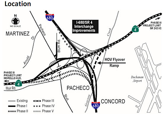 In April 2013, it was reported that there was finally a path ahead to
improving the interchange of I-680 and Route 4. This interchange is so
problematic that Contra Costa voters in 1988 approved a half-cent sales
tax to start planning its fix. Almost 25 years later, Contra Costa
County's congestion management agency says it has found a path to begin
the first phase of the $400 million freeway fix in about two years,
pulling it out of an indefinite limbo. Under earlier plans, the congestion
agency and Caltrans would have waited until the money was lined up to
build the most expensive yet effective parts of the five-phase project. To
break the logjam, the county agency revamped its construction staging and
financing plans. The agency plans to start smaller and have more money to
spend because of the improving economy. It would begin with widening three
miles of Route 4 to add an extra lane in each direction between Morello
Avenue and Route 242. The widening would cost some $50 million. The
transportation authority also figures it will have $186 million more than
previously expected over the next 21 years because of improvements in its
financial picture. The agency is taking in more sales tax revenues as the
economy recovers. The authority also got an "AA+" credit rating last fall
from two rating agencies, enabling it to save millions of dollars in
selling $225 million in bonds in December, and refinancing $200 million of
existing debt. With a rosier outlook ahead, the Transportation Authority
board on Wednesday is scheduled to authorize consultants to study design
on the highway widening. That action could lead to a widening contract
being awarded in 2015. In later phases of the freeway overhaul,
contractors will build new connector ramps, remove the cloverleaf
connectors, and add a flyover ramp so motorists can stay in a carpool lane
continuously while merging from one freeway to another. Getting started on
the project makes it easier to seek state and federal grants for later
phases of construction.
In April 2013, it was reported that there was finally a path ahead to
improving the interchange of I-680 and Route 4. This interchange is so
problematic that Contra Costa voters in 1988 approved a half-cent sales
tax to start planning its fix. Almost 25 years later, Contra Costa
County's congestion management agency says it has found a path to begin
the first phase of the $400 million freeway fix in about two years,
pulling it out of an indefinite limbo. Under earlier plans, the congestion
agency and Caltrans would have waited until the money was lined up to
build the most expensive yet effective parts of the five-phase project. To
break the logjam, the county agency revamped its construction staging and
financing plans. The agency plans to start smaller and have more money to
spend because of the improving economy. It would begin with widening three
miles of Route 4 to add an extra lane in each direction between Morello
Avenue and Route 242. The widening would cost some $50 million. The
transportation authority also figures it will have $186 million more than
previously expected over the next 21 years because of improvements in its
financial picture. The agency is taking in more sales tax revenues as the
economy recovers. The authority also got an "AA+" credit rating last fall
from two rating agencies, enabling it to save millions of dollars in
selling $225 million in bonds in December, and refinancing $200 million of
existing debt. With a rosier outlook ahead, the Transportation Authority
board on Wednesday is scheduled to authorize consultants to study design
on the highway widening. That action could lead to a widening contract
being awarded in 2015. In later phases of the freeway overhaul,
contractors will build new connector ramps, remove the cloverleaf
connectors, and add a flyover ramp so motorists can stay in a carpool lane
continuously while merging from one freeway to another. Getting started on
the project makes it easier to seek state and federal grants for later
phases of construction.
(Source: Contra Costa Times, 4/14/13)
In March 2015, the CTC received notice of a future STIP amendment from the Contra Costa Transportation Authority (CCTA), which proposed to delay $36,610,000 in Regional Improvement Program (RIP) construction funds from Fiscal Year (FY) 2015-16 to FY 2016-17 for the I-680/Route 4 Interchange – Phase 3 project (PPNO 0298E) in Contra Costa County. As of March 2015, the Phase 3 project was programmed with $36,610,000 in RIP construction in FY 2015-16. This Phase 3 project scope consists of widening Route 4 in the median to construct an additional lane in each direction from Morello Avenue to Route 242. The current scope of work also includes widening of various bridge structures within the project limits. Originally, the highway bridge structure spanning the Grayson Creek was planned to be widened. However, based upon a detailed analysis and evaluation of the condition of this aged structure, was determined that it is necessary to replace it. Furthermore, permits from the US Army Corp of Engineers will now be needed for both the Grayson Creek bridge replacement and the Walnut Creek bridge widening work. The CCTA is actively seeking additional funds to cover the cost of replacing the Grayson Creek Bridge. However, if additional funding does not materialize, the overall project cost will be reduced by adjusting the westbound projects limits. As a result of additional design efforts and the above described permit requirements, the delivery of the project will be delayed from Fiscal Year 2015-16 to 2016-17. In May 2015, the STIP amendment showed up on the CTC agenda and was approved.
In March 2016, it was reported that the MTC, in
response to state budget cuts, had tentatively cut the I-680/Route 4
project, putting off their funding until at least 2021. The project would
construct a new interchange where I-680 meets Route 4 in Contra Costa
County. The interchange would replace an outdated and overwhelmed
cloverleaf design that’s snarled with commuters forced to weave in
and out of traffic.
(Source: SF Gate, 3/10/2016)
In March 2017, the CTC amended the STIP to change the implementing agency on the right of way portion of the project. That amended provided the following additional innformation: On March 20, 2014, the Commission adopted the 2014 STIP, which included the I-680/ Route 4 Interchange – Phase 3 project. It consists of widening Route 4 by constructing an additional lane in each direction from Morello Avenue to Route 242. The project was programmed with $36,610,000 in Regional Improvement Program (RIP) funding for construction and the R/W phase was funded 100 percent with local funds. Then in September 2014, CCTA decided to have the Department take the lead in doing the R/W work and amended their cooperative agreement to reflect the change. On May 18, 2016, the Commission adopted the 2016 STIP, and due to funding shortfalls, CCTA was forced to delete STIP funding from existing projects. CCTA deleted $31,510,000 in STIP RIP funding for construction of the I-680/ Route 4 Interchange project and replaced it with local funds. The remaining $5,100,000 in STIP RIP funding for construction was reprogrammed to fund cost increases for R/W in FY 2017-18. The cost increases resulted from additional utility work that had not been previously identified. Currently, R/W is still programmed with CCTA as the implementing agency however, this amendment revises the implementing agency from CCTA to have the Department take the lead. This amendment also splits R/W into $4,800,000 Capital and $300,000 support and also updates the local funding in the funding plan.
The 2018 STIP, approved at the CTC March 2018 meeting, appears to adjust the funding for PPNO 0298E, Route 4/I-680 Interchange Phase 3, Widen Route 4 in the median to provide a third lane in each direction from Morello Avenue to Route 242 (PM R10.5/R15.1). This scope of work also includes widening/replacing/ various bridges within the project limits. The 2018 STIP restores $18,800K in funding for construction in FY19-20.
In May 2018, the CTC approved for future consideration
of funding the following project for which a Negative Declaration (ND) has
been completed: I-680 and Route 4 in Contra Costa County. Construct
interchange improvements on I-680 at Route 4 in Contra Costa County.
(0298E) (04-CC-680, PM 20.22/22.2, 04-CC-4, PM R10.5/15.1) This project is
located at the I-680/Route 4 interchange in Contra Costa County. The
project proposes to widen Route 4, widen five bridge structures and
replace the Grayson Creek Bridge. The existing I-680/Route 4 interchange
has deficiencies that contribute to traffic congestion and inefficient
traffic operations. The project proposes to reduce traffic congestion,
improve operation efficiency and accommodate existing and planned growth
in travel demand. This project is proposed to be implemented in five
phases for an estimated cost of $297.6 million. The project is not fully
funded and is currently programmed for $102.6 million in STIP, SHOPP,
Senate Bill (SB) 1 Local Partnership Program (LPP) and Local programs.
Construction for Phase 3 is estimated to begin in 2018. The scope, as
described for the preferred alternative, is consistent with the project
scope programmed by the Commission in the 2018 STIP.
(Source: CTC Agenda, May 2018 Agenda Item 2.2c(1))
In May 2018, it was reported that upgrades to the
I-680/Route 4 interchange in Pacheco, considered a bottleneck for traffic
in Contra Costa County, are closer to reality after the California
Transportation Commission approved $34 million in funding for
improvements. The funding, approved by the CTC at its May meeting, comes
about two and a half years after a group of politicians, union leaders and
transportation officials gathered in a parking lot near the interchange to
decry the proposed cut of more than $750 million from planned
transportation projects statewide.
(Source: SF Gate, 5/21/2018)In July 2018, it was reported that utility location for the interchange project was taking place. The project will
build a three-level interchange with two-lane ramps for the northbound to
westbound and eastbound to southbound movements. It will also widen Route 4 from four to six lanes, eliminate the current eastbound lane drop on
Highway 4 west of Pacheco Boulevard and construct auxiliary lanes to
adjacent interchange ramps at Morello Avenue and Solano Way on Route 4,
and Pacheco Boulevard and Concord Avenue on I-680.
(Source: Mercury News, 7/18/2018)
The project is being constructed in five phases:
Due to funding shortfalls, Phase 3 will be constructed
first. The remaining phases will be constructed as funding becomes
available. All phases were environmentally cleared in November 2008. Phase
3 environmental revalidation was completed in December 2015. Phase 3
design is complete as of July 2018, and Caltrans was preparing the bid
package to advertise the project for construction. Utility coordination
efforts with Kinder Morgan, Phillips 66, and Contra Costa Water District
(CCWD) were led by Caltrans, and relocation work begin in June 2018 and
was expected to finish in October 2018. Phase 3 construction bid
advertisement is planned for July 2018. Construction was expected to start
in Fall 2018.
(Source: CCTA Project Fact Sheet)
In January 2019, it was reported that work has begun to
widen a four-mile stretch of Route 4, a project that transportation
officials say will help reduce traffic and improve safety at its
intersection with I-680. The project will entail adding a third lane in
the east- and westbound directions between Morello Avenue in Martinez and
Route 242. It’s the first phase of a multi-phase project that will
eventually include lengthening the carpool lane on Route 4 by two miles,
installing safety lighting, widening highway structures and building ramp
connectors. The first phase, which will also include replacing the Grayson
Creek Bridge, is expected to be finished in 2021 and cost $136.2 million
— of which $77.7 million will come from SB1 funds that Assemblyman
Tim Grayson, D-Concord, worked to secure. Funding has not yet been
obtained for future phases of the project. In addition to widening Route 4, the project will raise the profile of the roadway slightly, allowing it
to be more “resilient.” More lighting and traffic striping is
intended to improve roadway visibility. And in addition to the Grayson
Creek Bridge, which will be replaced with a new three-span road bridge
structure, more widening and retrofit work will take place on the Walnut
Creek Bridge, Solano Way Undercrossing and Peralta Road Undercrossing.
(Source: East Bay Times, 1/25/2019)
In June 2019, it was reported that the Contra Costa
Transportation Authority (CCTA) and the California Department of
Transportation (Caltrans) are plugging away on the first phase of a
multi-phased project to improve safety and help reduce congestion. The
initial phase of construction involves widening a 4-mi. segment of Route 4
in both directions between Morello Avenue in Martinez and Route 242. The
work also involves the replacement of the Grayson Creek Bridge to bring it
up to current state bridge safety codes. Work began in November 2018 and
is scheduled for completion in late 2021 or early 2022. The project calls
for the addition of a third lane in the eastbound and westbound directions
to improve on-ramp and off-ramp merging. Along with the Grayson Creek
Bridge replacement, the project includes widening of four other bridges;
extending eastbound Route 4's carpool lane approximately 2 mi.; and
installation of safety lighting. More than 50 years old, the Grayson Creek
Bridge has exceeded its serviceable life. Currently the project is focused
on constructing the foundations for Grayson Creek Bridge and the four
other bridges to be widened. The entire project area extends about 4 mi.
along Route 4 and I-680. It crosses over three streets. The work is funded
by Measure J, a local transportation sales tax, state highway operation
and protection program, SB 1 and state transportation program dollars.
About 110,000 Yd3 of concrete will be used over the course of
the project. That does not include pre-cast or pre-fabricated concrete
brought on site including girders and pipe. About 42,000 tons of asphalt
will be placed as part of the project. The project lays the groundwork for
future improvements to connector ramps, improved traffic safety and
enhanced traffic flow. In addition to widening Route 4 in both directions,
the project will raise the roadway profile and widen the median and
outside shoulders at Grayson Creek. The project also will provide enhanced
lighting and traffic striping to improve roadway visibility during
nighttime hours.
(Source: Construction Equipment Guide, 6/4/2019)
In March 2020, the CTC approved the 2020 STIP, which
appeared to make no changes made in the amounts programmed for PPNO 0298E
Rt 680/4 interchange, widen Rt 4 (Ph3)(16S-03)(RW 1-19).
(Source: March 2020 CTC Agenda, Item 4.7, 2020 STIP
Adopted 3/25/2020)
In December 2020, it was reported that the CTC approved
$18 million for the final design of further improvements to the
I-680/Route 4 Interchange in Contra Costa County.
(Source: The Bay Link, 12/3/2020)
In May 2021, the CTC approved an allocation of
$18,000,000 for the locally-administered Senate Bill 1 (SB 1) Trade
Corridor Enhancement Program (TCEP) I-680/Route 4 Interchange Improvements
– Phases 1, 2 A project (PPNO 04-0298F; ProjID 0420000156; EA
22914), 04-CC-680 20.2/22.2; 04-CC-4 10.5/15.1). I-680/SR4
Interchange Improvements - Phases 1, 2 A. In Contra Costa
County near Concord and Martinez, Phase 1 will construct a two-lane
flyover direct connector from northbound I -680 to westbound Route 4 with
ramp metering, remove the existing northbound I-680 to westbound Route 4
loop ramp, construct auxiliary lanes on westbound Route 4 as well as
northbound I-680, and add a slip ramp from northbound I-680 to Pacheco
Blvd. Phase 2A would extend the southbound I -680 collector-distributor
ramp and install a ramp metering facility. PS&E $18,000,000. (Future
consideration of funding approved under Resolution E-18-37; May 2018.)
(Contribution from other sources: $8,000,000.)
(Source: May 2021 CTC Agenda, Agenda Item 2.5s.(5))
In March 2022, the CTC approved amending the SB1-TCEP
I-680/ State Route 4 Interchange Improvements – Phases 1 and 2A
Project (PPNO 0298F), in Contra Costa County, to add Phase 4 to the
originally approved allocation in May 2021. Phase 4 is the SB I‐680
to EB Route 4 connector. During recent project reviews, it was determined
that some design work activities, related to the Phase 4 project component
of the scope, overlap with Phase 1 and 2A of the project. It also became
evident that by combining some common work activities related to the Phase
4 project portion of the scope with the Phase 1 and 2A portions, the
project team will be able to take advantage of the efficiencies gained due
to overlapping activities to deliver the additional scope without
additional funding.
(Source: March 2022 CTC Agenda, Agenda Item
2.1s.(1))
In July 2023, it was reported that in June 2023 MTC
last month formally approved the first allocations of Regional Measure 3
dollars, releasing over $270 million for nine projects for which the
sponsors already were moving ahead under Letters of No Prejudice. These
initial allocations included: Contra Costa Transportation Authority: $13
million for ongoing work to reconfigure the I-680/Route 4 interchange.
(Source: MTG/ABAG Bay Link Blog, 7/12/2023)
Benicia-Martinez Bridge
In February 2010, the toll increased to $5 at all times on the Dumbarton, San Mateo, Richmond-San Rafael, Carquinez, Benicia-Martinez and Antioch bridges. In July 2010, the toll will be extended to carpoolers, who will pay $2.50.
In September 2019, it was reported that the
Metropolitan Transportation Commission gave the green light on a $4
million contract with a consultant for an all-electronic tolling system
for all bay area bridges, except the Golden Gate which is its own district
and has already gone cashless.. Drivers must pay with FasTrak only. For
those without FasTrak, cameras will capture your license plate and you'll
get a bill in the mall. The commission said it will save drivers time and
the agency money. Drivers won't have to slow down to squeeze through a
toll booth. Toll booths will be removed. The commission anticipates
realistically it could take up to five years for the system to go into
effect. The Carquinez Bridge will likely be the first to go cashless. MTC
said engineers say it's a good test bed to move faster on the others. The
Bay Bridge will be likely be last since it's the busiest. The toll
authority first authorized the move to all-electronic, open road tolling
in December 2018. The consultants jsut approved will be responsible for
developing the toll system’s specifications, providing oversight of
the program’s implementation, reviewing design plans, and help to
develop policies for all-electronic tolling. Bridges under the purview of
the toll authority include the Antioch Bridge, Benicia-Martinez Bridge,
Carquinez Bridge, Dumbarton Bridge, Richmond-San Rafael Bridge, San
Mateo-Hayward Bridge and the San Francisco-Oakland Bay Bridge.
(Source: KTVU, 9/1/2019; SFExaminer,
9/4/2019)
 Naming
The portion of this route from the Route 280/US 101 junction to the Santa Clara/Alameda County line (~ SCL M0.095 to SCL M9.906) is named the "Sinclair Freeway". Joseph P. Sinclair was District Engineer for the District 4 Division of Highways (now Caltrans) from 1952 to 1964. Named by Assembly Concurrent Resolution 104, Chapt. 168 in 1967. His son, Mike Sinclair, provided more information regarding his father: This stretch of I-280 and I-680 provided San Jose with its first freeway service. The concept for the freeway took shape during the tenure of Joseph Sinclair as District Engineer in charge of District IV, California State Division of Highways (now Caltrans), from 1959 to 1964. Route location studies were initiated in 1955, and adopted as part of the Interstate System in 1962. Much planning and research went into the design of this freeway in order to provide both a beautiful and functional facility. The City of San Jose and the Division of Highways negotiated a cooperative agreement for the development of park and recreational facilities within the freeway right-of-way at six locations along this route in a precedent-setting Freeway/Parks concept. To make the freeway more compatible with the adjacent residential properties, the first noise barrier in the Bay Area was installed. The freeway passed through an old Olive orchard. Many of the trees were removed and replanted within the freeway right of way to preserve these old trees. The freeway was landscaped and was officially designated as a "landscape freeway". When a freeway gets this official designation it eliminates the possibility of outdoor advertising being placed adjacent to the freeway. Sinclair was a pioneer in the design and routing of the state's freeway system. Born in Minnesota in 1910, he joined the Division of Highways in 1932 as rodman on a survey party, after graduation from the University of Southern California as a civil engineer. Subsequently, he filled positions of increasing responsibility as a freeway planner, designer, and builder in San Diego and Los Angeles, prior to coming to San Francisco in 1952. During World War II he served as Lieutenant Commander in the US Navy Seabees, stationed in the South Pacific. At the time of his death in 1964 he had become nationally known in his profession. In designating a freeway in his honor, the legislature for the first time named a highway after a civil engineer.
 The portion of this route between the intersection with I-580 and Alcosta Boulevard in San
Ramon (~ ALA R20.007 to ALA R21.875) is officially named the "Officer
John Paul Monego Memorial Freeway." It was named after Dublin Police
Officer John Paul Monego, who died on December 12, 1998, in the line of
duty at the age of 33 years, while responding to a takeover robbery.
Deputy Monego had been with the department for nine years and was survived
by his wife and 18-month-old son. He was the first deputy to be murdered
in the department's 146 year history. Deputy John Monego was shot and
killed after responding to a 911 hang-up call at a local restaurant.
Deputy Monego was the second deputy on the scene. When the first deputy
went inside the building to investigate the call she was overpowered by
the suspects, who then took her sidearm. As Deputy Monego approached the
front door the suspects opened fire through a glass window, striking him
in the chest, slightly above his ballistic vest. After Monego fell to the
ground the shooter walked outside and shot him five more times at close
range. The first deputy then called for assistance as the suspects fled
the restaurant. Deputy Monego was transported to a local hospital where he
was pronounced dead approximately 20 minutes later. hree suspects were
later arrested after a short pursuit. Each suspect was charged with murder
in the commission of a robbery, murder of a police officer, and false
imprisonment. The shooter was found guilty and sentenced to life without
the possibility of parole. Named by Senate Concurrent Resolution 60,
enrolled August 18, 2000.
The portion of this route between the intersection with I-580 and Alcosta Boulevard in San
Ramon (~ ALA R20.007 to ALA R21.875) is officially named the "Officer
John Paul Monego Memorial Freeway." It was named after Dublin Police
Officer John Paul Monego, who died on December 12, 1998, in the line of
duty at the age of 33 years, while responding to a takeover robbery.
Deputy Monego had been with the department for nine years and was survived
by his wife and 18-month-old son. He was the first deputy to be murdered
in the department's 146 year history. Deputy John Monego was shot and
killed after responding to a 911 hang-up call at a local restaurant.
Deputy Monego was the second deputy on the scene. When the first deputy
went inside the building to investigate the call she was overpowered by
the suspects, who then took her sidearm. As Deputy Monego approached the
front door the suspects opened fire through a glass window, striking him
in the chest, slightly above his ballistic vest. After Monego fell to the
ground the shooter walked outside and shot him five more times at close
range. The first deputy then called for assistance as the suspects fled
the restaurant. Deputy Monego was transported to a local hospital where he
was pronounced dead approximately 20 minutes later. hree suspects were
later arrested after a short pursuit. Each suspect was charged with murder
in the commission of a robbery, murder of a police officer, and false
imprisonment. The shooter was found guilty and sentenced to life without
the possibility of parole. Named by Senate Concurrent Resolution 60,
enrolled August 18, 2000.
(Image source: Dublin Patch; Officer Down Memorial Page)
 The portion of this route from the Alcosta Blvd. interchange in San Ramon to about the Livorna Road interchange (~
ALA R21.875 to CC R11.309) in Walnut Creek/Alamo is named the "Donald
D. Doyle Highway". Doyle was born on Feb. 6, 1915, in Dinuba (Tulare
County). He started in the insurance business in San Francisco, selling
policies door to door. After serving in the Marines in World War II, he
continued in the insurance industry, ultimately serving as senior vice
president with Johnson & Higgins. Doyle entered the 1952 race in an
effort to meet more people and drum up business for his insurance agency.
But he won the seat and spent the next six years working hard as a
legislator. The highlight of Mr. Doyle's political career was the 1957
passage of the Short-Doyle Act, which was a milestone effort to provide
money for community mental health services, which is the way most
psychiatric care now is delivered in California. He also authored
legislation creating the ferry boat transportation system between Benecia
and Martinez. He retired from the Assembly in 1958. After leaving
the insurance business, Mr. Doyle became CEO of Bayview Federal Savings
and Loan. He was president and CEO of the San Francisco Chamber of
Commerce from 1990 to 1992. A chamber board member emeritus, he was
honored with a special Excellence in Business award in 1998 for his work
with St. Francis Hospital. He was a member of many Bay Area boards,
including Blue Cross, St. Francis Hospital, St. Mary's College and Langley
Porter Psychiatric Hospital at UCSF. Named by Senate Concurrent Resolution
69, Resolution Chapter 93, July 14, 1998. The signs indicating this were
erected in 1998.
The portion of this route from the Alcosta Blvd. interchange in San Ramon to about the Livorna Road interchange (~
ALA R21.875 to CC R11.309) in Walnut Creek/Alamo is named the "Donald
D. Doyle Highway". Doyle was born on Feb. 6, 1915, in Dinuba (Tulare
County). He started in the insurance business in San Francisco, selling
policies door to door. After serving in the Marines in World War II, he
continued in the insurance industry, ultimately serving as senior vice
president with Johnson & Higgins. Doyle entered the 1952 race in an
effort to meet more people and drum up business for his insurance agency.
But he won the seat and spent the next six years working hard as a
legislator. The highlight of Mr. Doyle's political career was the 1957
passage of the Short-Doyle Act, which was a milestone effort to provide
money for community mental health services, which is the way most
psychiatric care now is delivered in California. He also authored
legislation creating the ferry boat transportation system between Benecia
and Martinez. He retired from the Assembly in 1958. After leaving
the insurance business, Mr. Doyle became CEO of Bayview Federal Savings
and Loan. He was president and CEO of the San Francisco Chamber of
Commerce from 1990 to 1992. A chamber board member emeritus, he was
honored with a special Excellence in Business award in 1998 for his work
with St. Francis Hospital. He was a member of many Bay Area boards,
including Blue Cross, St. Francis Hospital, St. Mary's College and Langley
Porter Psychiatric Hospital at UCSF. Named by Senate Concurrent Resolution
69, Resolution Chapter 93, July 14, 1998. The signs indicating this were
erected in 1998.
(Image source: AARoads; Join California)
 The portion of I-680 from Bollinger Canyon Road to Crow Canyon
Road (~ CC R2.861 to CC R4.182) in the City of San Ramon in the County of
Contra Costa is named the "Detective Sergeant Thomas A. Smith, Jr.
Memorial Highway". It was named in memory of Detective Sergeant
Thomas A. Smith, Jr., a 23-year veteran for the San Francisco Bay Area
Rapid Transit (BART) Police Department, who was accidentally fatally shot
by a fellow officer, at 42 years of age, when he led a team of eight
officers in a search of a robbery suspect’s apartment at 6450
Dougherty Road in Dublin, California, at about 2 p.m. on January 21, 2014.
Born in Hayward, California, in 1971, Detective Sergeant Thomas A. Smith
Jr., known as Tommy to his family and friends, grew up to serve as a
police officer in the bay area. Shortly after graduating from Moreau
Catholic High School, he attended the police academy at the Alameda County
Regional Training Center to train for the BART Police Department.
Detective Smith dedicated himself to the BART Police Department. Joining
the department at 19 years of age as a cadet, he rose through the ranks,
serving as a K-9 Handler, Field Training Officer, Recruit Training Officer
for the Contra Costa County Law Enforcement Training Center [Class
No.158], before becoming a detective and eventually being promoted to the
rank of sergeant, where he became the leader of the BART Police
Department’s Detective Unit. On January 21, 2014, members of the
detective unit converged on an apartment in Dublin, California, to perform
a probation search belonging to a suspect in several robberies on BART
property. During the search, an officer fired a single shot, which
unfortunately hit Detective Sergeant Tommy Smith, missing his protective
vest. Tommy was rushed to a hospital, but succumbed to his wound a short
time later. He was the first BART police officer killed in the line of
duty in its 42-year history. As dedicated as he was to his career,
Detective Sergeant Tommy Smith made family his first priority. In 1995, he
met his wife, Kellie, a fellow BART police officer, whom he married in
2001. He made their daughter Summer a top priority. So it was not
surprising, when driving home one day that Summer noticed that an exit
number had been added to the Bollinger Canyon Road exit along Interstate 680. The Bollinger Canyon Road exit is now number “34.” Number
34 was Detective Sergeant Tommy Smith’s badge number. Named by
Assembly Concurrent Resolution (ACR) 22, 8/30/2017, Res. Chapter 127,
Statutes of 2017.
The portion of I-680 from Bollinger Canyon Road to Crow Canyon
Road (~ CC R2.861 to CC R4.182) in the City of San Ramon in the County of
Contra Costa is named the "Detective Sergeant Thomas A. Smith, Jr.
Memorial Highway". It was named in memory of Detective Sergeant
Thomas A. Smith, Jr., a 23-year veteran for the San Francisco Bay Area
Rapid Transit (BART) Police Department, who was accidentally fatally shot
by a fellow officer, at 42 years of age, when he led a team of eight
officers in a search of a robbery suspect’s apartment at 6450
Dougherty Road in Dublin, California, at about 2 p.m. on January 21, 2014.
Born in Hayward, California, in 1971, Detective Sergeant Thomas A. Smith
Jr., known as Tommy to his family and friends, grew up to serve as a
police officer in the bay area. Shortly after graduating from Moreau
Catholic High School, he attended the police academy at the Alameda County
Regional Training Center to train for the BART Police Department.
Detective Smith dedicated himself to the BART Police Department. Joining
the department at 19 years of age as a cadet, he rose through the ranks,
serving as a K-9 Handler, Field Training Officer, Recruit Training Officer
for the Contra Costa County Law Enforcement Training Center [Class
No.158], before becoming a detective and eventually being promoted to the
rank of sergeant, where he became the leader of the BART Police
Department’s Detective Unit. On January 21, 2014, members of the
detective unit converged on an apartment in Dublin, California, to perform
a probation search belonging to a suspect in several robberies on BART
property. During the search, an officer fired a single shot, which
unfortunately hit Detective Sergeant Tommy Smith, missing his protective
vest. Tommy was rushed to a hospital, but succumbed to his wound a short
time later. He was the first BART police officer killed in the line of
duty in its 42-year history. As dedicated as he was to his career,
Detective Sergeant Tommy Smith made family his first priority. In 1995, he
met his wife, Kellie, a fellow BART police officer, whom he married in
2001. He made their daughter Summer a top priority. So it was not
surprising, when driving home one day that Summer noticed that an exit
number had been added to the Bollinger Canyon Road exit along Interstate 680. The Bollinger Canyon Road exit is now number “34.” Number
34 was Detective Sergeant Tommy Smith’s badge number. Named by
Assembly Concurrent Resolution (ACR) 22, 8/30/2017, Res. Chapter 127,
Statutes of 2017.
(Image source: CHP Dublin on Twitter; Officer Down Memorial Page)
The portion of this route from Route 24 to Route 4 is historically part of "El Camino Sierra" (The Road to the Mountains). (~ CC 14.359 to CC 21.022)
 The portion of I-680
that is between Route 24 in the City of Walnut Creek and the
Benicia-Martinez Bridge in Contra Costa County (~ CC 14.359 to CC 025.04)
is named the "Senator Daniel E. Boatwright Highway". This segment
was named in honor of Senator Daniel E. Boatwright, who was elected to the
California State Senate in 1980, and served for 16 years in the 7th Senate
District, , as well as serving for eight years in the California State
Assembly, to which he was first elected in 1972. Senator Boatwright was
born in Harrison, Arkansas, but moved to Vallejo, California, as a child,
where he attended public schools, where his education was interrupted by
service in the United States Army as a combat member of the infantry in
Korea. Boatwright attended Vallejo Junior College where he was chairman of
the student council and Chairman of the California Community Colleges
Student Council Association, and went on to receive both his B.A. degree
and his law degree from the University of California at Berkeley.
Boatwright served as deputy district attorney in Contra Costa County,
becoming chief trial deputy under then District Attorney John Nejedly
before opening his own law firm in Concord in 1970. Boatwright served as a
city council member and Mayor of the City of Concord, Chairman of the
Contra Costa County Consolidated Fire Board, and City Attorney for the
City of Brentwood prior to his election to the California State Assembly.
During his 24-year legislative career, he authored more than 350 laws and
held several prominent committee chairmanships in each house, including
chairmanships of the Assembly and Senate Revenue and Taxation Committees,
the Assembly Ways and Means Committee, and the Senate Appropriations
Committee, in which capacities he became legendary for his ability, year
after year, to deliver state funding to cities, the county, and special
districts for projects in his Contra Costa County-based district. From
1982 through 1992, Senator Boatwright worked tirelessly with the
California Transportation Commission, the Department of Transportation,
and the Department of Finance to secure funding and accelerate the
construction and completion of I-680 lane additions and the I-680 and
Route 24 interchange in Contra Costa County. Following his retirement from
the Legislature in 1996, Senator Boatwright served as the Senate's
representative in 1997 and 1998 to the California Medical Assistance
Commission, and has since resumed the practice of law and begun the
practice of lobbying. Named by Senate Concurrent Resolution (SCR) 4,
Resolution Chapter 69, on 7/14/2009.
The portion of I-680
that is between Route 24 in the City of Walnut Creek and the
Benicia-Martinez Bridge in Contra Costa County (~ CC 14.359 to CC 025.04)
is named the "Senator Daniel E. Boatwright Highway". This segment
was named in honor of Senator Daniel E. Boatwright, who was elected to the
California State Senate in 1980, and served for 16 years in the 7th Senate
District, , as well as serving for eight years in the California State
Assembly, to which he was first elected in 1972. Senator Boatwright was
born in Harrison, Arkansas, but moved to Vallejo, California, as a child,
where he attended public schools, where his education was interrupted by
service in the United States Army as a combat member of the infantry in
Korea. Boatwright attended Vallejo Junior College where he was chairman of
the student council and Chairman of the California Community Colleges
Student Council Association, and went on to receive both his B.A. degree
and his law degree from the University of California at Berkeley.
Boatwright served as deputy district attorney in Contra Costa County,
becoming chief trial deputy under then District Attorney John Nejedly
before opening his own law firm in Concord in 1970. Boatwright served as a
city council member and Mayor of the City of Concord, Chairman of the
Contra Costa County Consolidated Fire Board, and City Attorney for the
City of Brentwood prior to his election to the California State Assembly.
During his 24-year legislative career, he authored more than 350 laws and
held several prominent committee chairmanships in each house, including
chairmanships of the Assembly and Senate Revenue and Taxation Committees,
the Assembly Ways and Means Committee, and the Senate Appropriations
Committee, in which capacities he became legendary for his ability, year
after year, to deliver state funding to cities, the county, and special
districts for projects in his Contra Costa County-based district. From
1982 through 1992, Senator Boatwright worked tirelessly with the
California Transportation Commission, the Department of Transportation,
and the Department of Finance to secure funding and accelerate the
construction and completion of I-680 lane additions and the I-680 and
Route 24 interchange in Contra Costa County. Following his retirement from
the Legislature in 1996, Senator Boatwright served as the Senate's
representative in 1997 and 1998 to the California Medical Assistance
Commission, and has since resumed the practice of law and begun the
practice of lobbying. Named by Senate Concurrent Resolution (SCR) 4,
Resolution Chapter 69, on 7/14/2009.
(Image source: Flikr; El Cerrito Patch)
 Named Structures
 The interchange of I-680, I-280, and US 101 in the
City of San Jose (~ SCL M0.095) is named the "Joe Colla Interchange."
This interchange was named in memory of Joseph Anthony Colla, who actively
served the San Jose community during the 1970s as a pharmacist, bike
racer, bike race promoter, and San Jose City Council Member. Councilman
Joe Colla worked in the 1970s alongside future mayors Norman Mineta and
Janet Gray Hayes to help the City of San Jose develop economically and
culturally and become described as "San Jose, a City with a Future". Colla
is best known for a stunt involving the US 101/I-680/I-280 interchange.
Construction started on that interchange, and then stopped as then-Gov.
Jerry Brown suspended most highway building in the state in a cost-cutting
measure. Road crews disappeared and what remained was a 200-foot ramp
suspended in the air with rebar sticking out of both ends. The ramp was
dubbed San Jose's "Monument to Nowhere." In the pre-dawn hours of a sunny
but chilly January day, Colla got a crane operator to lift a Chevy on top
of the unfinished ramp. Then the feisty councilman and drugstore owner
jumped in a helicopter, which dropped him off next to the car. A
photograph was snapped of Colla with arms outstretched and the caption:
"Where Do We Go From Here?"As a direct result of Councilman Joe Colla's
exploits, including posing the question, "Where do I drive from here?"
from atop the unfinished interchange, and identifying the monolith as "A
Monument to Nowhere." This made Colla a true urban legend. After the car
stunt, he organized a 300-car caravan to Sacramento to push for the
interchange's completion. Eventually the City of San Jose received the
necessary funding and the interchange project was completed. Named by
Assembly Concurrant Resolution (ACR) 102, August 30, 2010, Resolution
Chapter 107.
The interchange of I-680, I-280, and US 101 in the
City of San Jose (~ SCL M0.095) is named the "Joe Colla Interchange."
This interchange was named in memory of Joseph Anthony Colla, who actively
served the San Jose community during the 1970s as a pharmacist, bike
racer, bike race promoter, and San Jose City Council Member. Councilman
Joe Colla worked in the 1970s alongside future mayors Norman Mineta and
Janet Gray Hayes to help the City of San Jose develop economically and
culturally and become described as "San Jose, a City with a Future". Colla
is best known for a stunt involving the US 101/I-680/I-280 interchange.
Construction started on that interchange, and then stopped as then-Gov.
Jerry Brown suspended most highway building in the state in a cost-cutting
measure. Road crews disappeared and what remained was a 200-foot ramp
suspended in the air with rebar sticking out of both ends. The ramp was
dubbed San Jose's "Monument to Nowhere." In the pre-dawn hours of a sunny
but chilly January day, Colla got a crane operator to lift a Chevy on top
of the unfinished ramp. Then the feisty councilman and drugstore owner
jumped in a helicopter, which dropped him off next to the car. A
photograph was snapped of Colla with arms outstretched and the caption:
"Where Do We Go From Here?"As a direct result of Councilman Joe Colla's
exploits, including posing the question, "Where do I drive from here?"
from atop the unfinished interchange, and identifying the monolith as "A
Monument to Nowhere." This made Colla a true urban legend. After the car
stunt, he organized a 300-car caravan to Sacramento to push for the
interchange's completion. Eventually the City of San Jose received the
necessary funding and the interchange project was completed. Named by
Assembly Concurrant Resolution (ACR) 102, August 30, 2010, Resolution
Chapter 107.
(Image source: Mercury News; Calisphere; Mercury News)
 The
The Grimmer Boulevard Bridge in the City of Fremonton I-680 portion
of I-680 at Auto Mall Parkway in the County of Alameda (~ ALA
M4.032) is named the "CHP Officers Fredrick Wayne Enright and Adolfo
Martinez Hernandez Memorial Bridge". It was named in memory of
Officers Frederick Wayne Enright and Adolfo Martinez Hernandez, who made
the ultimate sacrifice while performing their sworn duty. Officer
Frederick Wayne Enright was born August 27, 1944, to Francis Xavier and
Mary Alice, in Louisiana, Missouri. Officer Enright, badge number 7857,
graduated from the CHP Academy in March of 1972 with the Cadet Training
Class V-71, and upon graduation he was assigned to the West Valley area.
After only six months with the CHP, Officer Enright achieved the rank of
pilot and was transferred to the Golden Gate Division in the San Francisco
Bay Area. As a helicopter pilot, Officer Enright responded to numerous
land and water rescue operations and routinely flew commute traffic
observation for bay area highways and freeways. During one of Officer
Enright’s patrols, he encountered a drunk pilot, ordered him to land
and escorted him to the ground, where the pilot was arrested. Not only was
this a dangerous encounter, but the aircraft suffered power failure and
Officer Enright successfully landed the helicopter without damage or
injury. The CHP subsequently commended him for his exceptional skill and
decisionmaking during this incident. Officer Adolfo Martinez Hernandez was
born September 27, 1940, to Tiburcio and Juana in Etiwanda, California,
and is one of 12 children. Officer Hernandez, badge number 4876, graduated
from the CHP Academy in 1966, and proudly served the citizens of
California for nine years. Officer Hernandez was a devoted officer,
husband, and father. He was known for his big heart and immense love for
his family and friends, even when some of them were
“unlovable.” He enjoyed playing with his children,
motorcycles, refurbishing a Volks Wagen van, making wood carvings,
creating leather items including wallets, handbags, sandals, belts, and a
special holder for his CHP badge. He also loved
“do-it-yourself” projects and built a bicycle seat for his
daughter, a bike rack for his car, and a bookcase and small end table that
his son still has in his home today. On June 27, 1975, the State of
California suffered a tragic loss when CHP Officers Frederick Wayne
Enright and Adolfo Martinez Hernandez were killed in a helicopter crash
caused by mechanical failure. Named by Assembly Concurrent Resolution 100,
Resolution Chapter 109, on September 4, 2012. Redesignated to Auto
Mall Parkway by Senate Concurrent Resolution 125, Resolution Chapter
133, on August 28, 2014.
(Image source: National Latinos Police Officers Assn; Officer Down Memorial Page)
 The Fostoria Overcrossing on I-680 (Bridge 28-0316, CC R004.38) in the City of San
Ramon is named the "Thomas E. Burnett, Jr. Memorial Bridge". Named
in honor of Thomas E. Burnett, Jr., who lived with his wife Deena and
daughters Halley, Madison, and Anna Claire in the City of San Ramon. On
September 11, 2001, terrorists hijacked four civilian aircraft, crashing
two of them into the twin towers of the World Trade Center in New York
City, and a third into the Pentagon outside Washington, D.C., and a fourth
hijacked aircraft that crashed in southwestern Pennsylvania. Thomas E.
Burnett, Jr. was a passenger on the fourth flight (United Airlines 93),
and led the passengers in trying to take control of the aircraft in order
to prevent the hijackers from probably crashing the aircraft in Washington
D.C.. These heroic actions taken by Thomas E. Burnett, Jr. and his fellow
passengers likely prevented the further loss of life. Named by Assembly
Concurrent Resolution 38, Chaptered 7/2/2003, Chapter 84.
The Fostoria Overcrossing on I-680 (Bridge 28-0316, CC R004.38) in the City of San
Ramon is named the "Thomas E. Burnett, Jr. Memorial Bridge". Named
in honor of Thomas E. Burnett, Jr., who lived with his wife Deena and
daughters Halley, Madison, and Anna Claire in the City of San Ramon. On
September 11, 2001, terrorists hijacked four civilian aircraft, crashing
two of them into the twin towers of the World Trade Center in New York
City, and a third into the Pentagon outside Washington, D.C., and a fourth
hijacked aircraft that crashed in southwestern Pennsylvania. Thomas E.
Burnett, Jr. was a passenger on the fourth flight (United Airlines 93),
and led the passengers in trying to take control of the aircraft in order
to prevent the hijackers from probably crashing the aircraft in Washington
D.C.. These heroic actions taken by Thomas E. Burnett, Jr. and his fellow
passengers likely prevented the further loss of life. Named by Assembly
Concurrent Resolution 38, Chaptered 7/2/2003, Chapter 84.
(Image source: Outgress; Alchetron)
 The I-680
 undercrossing
over Livorna Road below Bridge No. 28-191 in Contra Costa County interchange
with Route 24 in Contra Costa County (CC 014.24) is officially
named the "CHP Officer Kenyon Youngstrom Memorial Undercrossing
Interchange." It was named in memory of California
Highway Patrol (CHP) Officer Kenyon Marc Youngstrom, who was born in
October 1974 in Pasadena, California. CHP Officer Youngstrom graduated
from Arlington High School in Riverside in 1993, and attended California
Baptist University in Riverside, as well as Napa Valley College, in Napa.
From a young age, Youngstrom recognized the importance of public service,
and was known as a hard worker who always gave back to his community. He
served as a member of the United States Army Reserve for six years,
achieving the rank of an E-4 Specialist. He entered the CHP Academy in
August 2005 and graduated in February 2006 (badge number 18063), and was
initially assigned to the Contra Costa area. CHP Officer Youngstrom, after
serving nearly three years in the Contra Costa area, voluntarily
transferred to the Golden Gate Division as a member of the Field Support
Unit, where he served as a distinguished member of the Protective Services
Detail, responsible for providing protection to various dignitaries, heads
of state, legislators, and other VIPs visiting the San Francisco Bay Area.
He transferred back to the Contra Costa area in August 2012 where he spent
the remainder of his career. CHP Officer Youngstrom performed several
duties over the course of his career, and because of his exceptional
skills as an officer, he served as a mentor and recruiter for new officers
to the CHP, as well as a RADAR and LIDAR instructor. While assisting a
fellow officer on September 4, 2012 with an enforcement stop on I-680,
Officer Yongstrom was critically shot by the driver of the stopped
vehicle, and passed away the following day at the John Muir Medical Center
in Walnut Creek. Officer Youngstrom, upon his death, gave the gift of life
through organ and tissue donation, helping to save the lives of four
individuals. It The undercrossing over Livorna Road
was named on 09/06/13 by SCR 43, Res. Chapter 98, Statutes of 2013. The
naming was transferred (redesignated) to the interchange with Route 24
by Assembly Concurrent Resolution 67, Resolution Chapter 141, on
September 2, 2014.
(Image Source: ABC7 News; Mercury News)
 Bridge 28-0153 on Route 680
(CC 025.04) between Martinez and Benicia in Contra Costa and Solano
counties is named the "George Miller Jr. Bridge" (signed as "George
Miller Jr. Memorial Bridge"), and is also known as the "Benicia-Martinez
Bridge". George R. Miller, Jr., represented Contra Costa County in
the State Assembly (1947-1949) and the State Senate (1947-1968), and was
the father of Congressman George Miller III. Benicia-Martinez refers to
the cities connected by the bridge. They were named after the mid-19th
century figures Ignacio Martinez—commandante of the Presidio at San
Francisco and owner of Rancho El Pinole that extended from San Pablo Bay
to Martinez—and General Mariano Vallejo's wife, Francisca Benicia.
It was built in 1962, and was named by Assembly Concurrent Resolution 59,
Chapter 84 in 1975.
Bridge 28-0153 on Route 680
(CC 025.04) between Martinez and Benicia in Contra Costa and Solano
counties is named the "George Miller Jr. Bridge" (signed as "George
Miller Jr. Memorial Bridge"), and is also known as the "Benicia-Martinez
Bridge". George R. Miller, Jr., represented Contra Costa County in
the State Assembly (1947-1949) and the State Senate (1947-1968), and was
the father of Congressman George Miller III. Benicia-Martinez refers to
the cities connected by the bridge. They were named after the mid-19th
century figures Ignacio Martinez—commandante of the Presidio at San
Francisco and owner of Rancho El Pinole that extended from San Pablo Bay
to Martinez—and General Mariano Vallejo's wife, Francisca Benicia.
It was built in 1962, and was named by Assembly Concurrent Resolution 59,
Chapter 84 in 1975.
(Image source: Interstate Guide; Mercury News)
 The new northbound Benicia-Martinez Bridge (SOL R000.99) is named the "Congressman
George Miller Benicia-Martinez Bridge". This segment was named in
honor of Congressman George Miller, who was born in Richmond, California,
on May 17, 1945. Congressman Miller graduated from San Francisco State
University and received his law degree from the University of California,
Davis. He thereafter served on the staff of former State Senate Majority
Leader George Moscone. He has been a member of the United States Congress,
representing the Seventh District of California since 1975. His myriad
achievements include authoring laws concerning environmental protection
and resource management, energy policy, child care, mental health, aid to
victims of domestic violence, and numerous education reforms. He has
consistently championed federal support for California's diverse,
multimodal transportation system. His work was instrumental in
accomplishing all of the following: extending the BART rail system,
upgrading the Vallejo Baylink ferry service, reconfiguring the interchange
of I-680 and Route 24, establishing the intermodal rail and bus stations
in Martinez and Richmond, widening Route 4 between Martinez and Hercules
and between Pacheco and Pittsburg, and advancing the Vallejo Station
complex. He has been a tireless advocate for children and was one of the
four original authors of the historic No Child Left Behind Act of 2001,
which passed with strong bipartisan support in 2001 and was signed into
law in 2002. Reflecting Congressman Miller's ability to reach across party
lines, the act fulfilled many of his longstanding legislative efforts to
improve teacher quality requirements, to hold schools accountable for the
education of all children, and to provide federal financial support to
meet the act's goals. In January 2007, Congressman Miller was elected by
his colleagues to serve as chairman of the House Education and Labor
Committee, a panel on which he has served since his arrival in Congress
and as Senior Democrat since 2001. Congressman Miller continues to serve
on the House Natural Resources Committee, a panel he chaired from 1991 to
1994; in this capacity, he orchestrated a federal and state effort to meet
technical and environmental challenges created by construction of the new
Benicia-Martinez Bridge, an effort that led to several important
engineering advances, including the use of pumped air to create a bubble
curtain around underwater pile driving to protect migratory fish from
potentially lethal shockwaves. The original Benicia-Martinez Bridge, which
opened in 1962, was designated the George Miller, Jr., Memorial Bridge in
1975 to honor Congressman Miller's father, who represented Contra Costa
County in the California State Assembly from 1947 to 1948, and in the
California State Senate from 1949 until his death in 1969. Named by
Assembly Concurrent Resolution (ACR) 62, Resolution Chapter 107, on
8/23/2007.
The new northbound Benicia-Martinez Bridge (SOL R000.99) is named the "Congressman
George Miller Benicia-Martinez Bridge". This segment was named in
honor of Congressman George Miller, who was born in Richmond, California,
on May 17, 1945. Congressman Miller graduated from San Francisco State
University and received his law degree from the University of California,
Davis. He thereafter served on the staff of former State Senate Majority
Leader George Moscone. He has been a member of the United States Congress,
representing the Seventh District of California since 1975. His myriad
achievements include authoring laws concerning environmental protection
and resource management, energy policy, child care, mental health, aid to
victims of domestic violence, and numerous education reforms. He has
consistently championed federal support for California's diverse,
multimodal transportation system. His work was instrumental in
accomplishing all of the following: extending the BART rail system,
upgrading the Vallejo Baylink ferry service, reconfiguring the interchange
of I-680 and Route 24, establishing the intermodal rail and bus stations
in Martinez and Richmond, widening Route 4 between Martinez and Hercules
and between Pacheco and Pittsburg, and advancing the Vallejo Station
complex. He has been a tireless advocate for children and was one of the
four original authors of the historic No Child Left Behind Act of 2001,
which passed with strong bipartisan support in 2001 and was signed into
law in 2002. Reflecting Congressman Miller's ability to reach across party
lines, the act fulfilled many of his longstanding legislative efforts to
improve teacher quality requirements, to hold schools accountable for the
education of all children, and to provide federal financial support to
meet the act's goals. In January 2007, Congressman Miller was elected by
his colleagues to serve as chairman of the House Education and Labor
Committee, a panel on which he has served since his arrival in Congress
and as Senior Democrat since 2001. Congressman Miller continues to serve
on the House Natural Resources Committee, a panel he chaired from 1991 to
1994; in this capacity, he orchestrated a federal and state effort to meet
technical and environmental challenges created by construction of the new
Benicia-Martinez Bridge, an effort that led to several important
engineering advances, including the use of pumped air to create a bubble
curtain around underwater pile driving to protect migratory fish from
potentially lethal shockwaves. The original Benicia-Martinez Bridge, which
opened in 1962, was designated the George Miller, Jr., Memorial Bridge in
1975 to honor Congressman Miller's father, who represented Contra Costa
County in the California State Assembly from 1947 to 1948, and in the
California State Senate from 1949 until his death in 1969. Named by
Assembly Concurrent Resolution (ACR) 62, Resolution Chapter 107, on
8/23/2007.
(Image source: Gribblenation; Wikipedia)
 Interstate Submissions
Approved as chargeable Interstate on 9/15/1955; routing in San Jose adjusted in 10/64; Freeway.
In the first attempt to number urban routes, the California Department of Highways proposed this as I-5. The first proposal as a 3-digit route was as I-113. Once the numbering scheme for 3-digit interstates was finalized, the proposal changed to I-580. AASHTO finally approved this as I-680.
 Scenic Route
[SHC 263.8] From the Santa Clara-Alameda county line to Route 24 in Walnut Creek.
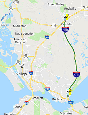 From Route 780 at Benicia to Route 80 near Cordelia.
Post 1964 Signage HistoryI-680 was originally adopted as a Freeway within Solano County in 1957.
▸In 1963, Route 680 was defined as "Route 280 in San Jose to Route 80 in Vallejo passing near Warm Springs, Mission San Jose, Scotts Corners and Sunol, and via Walnut Creek and Benicia."
▸In 1965, Chapter 1371 changed the origin of the route: "Route 280 Route 101 near San Jose to Route 80 in Vallejo
passing near Warm Springs, Mission San Jose, Scotts Corners and Sunol, and
via Walnut Creek and Benicia."
I-680 was completed between Benicia and Cordelia in 1966.
▸In 1976, Chapter 1354 added a second segment and changed the
terminus of (a): "(a) Route 101 near San Jose to Route 780 in
Vallejo at Benicia passing near Warm Springs, Mission
San Jose, Scotts Corners, and Sunol, and via Walnut Creek and
Benecia. (b) Route 780 at Benicia to Route 80 near
Cordelia." This was the result of a transfer from Route 21, combined
with a concurrent transfer to new I-780.
Pre 1964 Signage HistoryThis was LRN 74 (former Route 29) between Benicia and I-80 (former US 40). This segment was defined in 1933.
 Freeway
 In October 1955, the Sacramento Bee published a proposed
routing for what would become this segment of I-680, noting (edited to
correct OCR errors):
In October 1955, the Sacramento Bee published a proposed
routing for what would become this segment of I-680, noting (edited to
correct OCR errors):
(Source: Joel Windmiller, California's Historic Highways on FB, 6/2/2020)
State Considers Benicia-Vallejo Freeways. The state highway department is considering the adoption of freeway routings in the vicinity of Vallejo and Benicia in Solano County to provide connections to the proposed Benicia- Martinez Bridge and to US 40 near the Carquinez Bridge. State Highway Engineer G T McCoy yesterday recommended these routes: [LRN 74] (Benicia Road) between Vallejo and the proposed Benicia-Martinez Bridge [future I-780] is a route generally parallel to the existing highway [LRN 74], which might have been signed as Route 29] but slightly' to the south near Vallejo and to the north in the Benicia area. State Route 21 [future I-680] to the east of the existing highway rejoining it north of the Benicia Arsenal north boundary. Possible Hearing. The Solano supervisors and the Vallejo and Benicia City Councils will be asked if they believe a public hearing is necessary before the commission officially adopts the routes. McCoy said the route in the vicinity of Vallejo would be a relocation planned as an integral part of the proposed Carquinez parallel bridge project, and should be constructed at the same time that US 40 through Vallejo is converted to a full freeway. With regard to State Route 21 [I-680], McCoy said that with construction of the proposed Benicia-Martinez Bridge, it would become a part of the main north-south route connecting San Jose through Walnut Creek to US 40 west of Fairfield. Route Extension. In that connection, H J Walt, Benicia city administrator and Sol O Rose, Benicia city councilman, appeared at the commission meeting to request extension of the State Route 21 plan to provide a water level throughway from Benicia to Fairfield before Joining US 40 "We feel we have been fenced in long enough" said Walt "and such a route would offer al seven mile shortcut to the new bridge". Rose said 75 per cent of the citizens and property owners of' Benicia are opposed to any route that would bisect the city. The estimated cost of the LRN 74 improvement is! $6,600,000 and the Route' 21 improvement $3,000,000. Start' of construction would depend upon the availability of highway funds.
StatusInterstate 680 Rehabilitation Project
In January 2016, it was reported that the I-680
Rehabilitation Project was complete. The $13 million California Department
of Transportation (Caltrans) project rehabilitated and repaved about 13
miles of northbound and southbound I-680. Construction started in spring
2015 with final paving completed in mid-December 2015. The project
resurfaced the two northbound and two southbound traffic lanes of I-680,
repaired the existing median metal guardrails and roadway lighting.
(Source: East Bay Times, 1/11/2016)
I-80/I-680/Route 12 Interchange Project (~ SOL R10.903 to SOL 13.016)
The California Transportion Commission, in September 2000, considered a Traffic Congestion Relief Program proposal to reconstruct the I-80/I-680/Route 12 interchange; it would be a 12-interchange complex constructed in seven stages. The proposal was $1 million for stage 1; the total estimated cost was $13 million. This is TCRP Project #25, requested by the Solano Transportation Authority.
The SAFETEA-LU act, enacted in August 2005 as the reauthorization of TEA-21, provided the following expenditures on or near this route:
In his 2006 Strategic Growth Plan, Governor Schwartzenegger proposed constructing the I-80/I-680/Route 12 Interchange Complex, including HOV Connector Lanes.
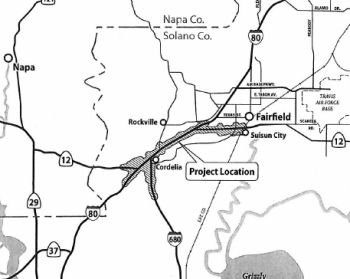 In January 2013, the CTC approved for future consideration of funding a project in Solano
County that will improve the I-80/I-680/Route 12 Interchange, including
the relocation of the westbound truck scales facility on I-80. For the
preferred full-build alternative, the current total estimated cost for
capital and support is $1,348,400,000. The project is not fully funded and
will be developed in phases. Only Phase One of the full-build alternative
is included in the financially constrained Regional Transportation Plan
(RTP). Within Phase One, the first construction contract's total estimated
cost for capital and support is $100,400,000, which is funded by the 2012
State Transportation Improvement Program (STIP), the Trade Corridor
Improvement Funds (TCIF) and local funding. The scope of the first
construction contract includes the reconstruction of the I-80/Green Valley
Interchange and construction of a two lane westbound I-80 to westbound
Route 12 Connector with a new bridge over the I-80 Green Valley Road
onramp. Construction is estimated to begin in fiscal year 2013-2014. The
scope of the preferred alternative is consistent with the scope of the
first construction contract that is programmed in the 2012 STIP and the
TCIF.
In January 2013, the CTC approved for future consideration of funding a project in Solano
County that will improve the I-80/I-680/Route 12 Interchange, including
the relocation of the westbound truck scales facility on I-80. For the
preferred full-build alternative, the current total estimated cost for
capital and support is $1,348,400,000. The project is not fully funded and
will be developed in phases. Only Phase One of the full-build alternative
is included in the financially constrained Regional Transportation Plan
(RTP). Within Phase One, the first construction contract's total estimated
cost for capital and support is $100,400,000, which is funded by the 2012
State Transportation Improvement Program (STIP), the Trade Corridor
Improvement Funds (TCIF) and local funding. The scope of the first
construction contract includes the reconstruction of the I-80/Green Valley
Interchange and construction of a two lane westbound I-80 to westbound
Route 12 Connector with a new bridge over the I-80 Green Valley Road
onramp. Construction is estimated to begin in fiscal year 2013-2014. The
scope of the preferred alternative is consistent with the scope of the
first construction contract that is programmed in the 2012 STIP and the
TCIF.
In May 2013, it was reported that the funding outlook for the updated I-80/I-680/Route 12 interchange was improving. The required permit from the U.S. Army Corps of Engineers was obtained, and the Solano Transportation Authority had done what it is supposed to do to get the project ready for construction. The project is designed to improve traffic flow near the I-80 / I-680 interchange. It involves renovating the nearby Green Valley interchange and building ramps to sort traffic entering westbound I-80 from the Green Valley interchange from traffic exiting I-80 for Route 12 in Jameson Canyon. Construction work is to cost $60 million. The $24 million at risk is to come from Proposition 1B, the transportation bond passed by voters in 2006. The potential obstacle stems from the Buy America provisions, which requires that projects that receive federal dollars be built with materials made in America. Revisions in the 2012 federal transportation bill extend these provisions to contracts, including utility agreements, associated with the projects.
According to Sean Tongson in June 2004, they are constructing a new Northbound Benicia Bridge. The current structure, that carries North and Soutbound traffic, will revert to a 5 lane, southbound only bridge. The toll plaza, currrently located on the Northbound lanes at the North end of the bridge, will be reconstructed, still using the Northbound lanes, to the south start of the Bridge. In addition, the I-680/I-780 interchange is being re-configured. In particular, the EB I-780 to NB I-680 left exit connector will be eliminated in favor of a huge flyover ramp, soaring over the current but soon to moved toll plaza.
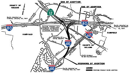 In December 2013, the CTC approved adoption of a new freeway route for Route 680 as part of the
reconstruction of the I-680/I-80/Route 12 interchange in Solano County.
I-680 was originally adopted as a freeway within Solano County in 1957,
and was completed between Benicia and Cordelia in 1966. The intent of this
project (and the route adoption) is to realign I-680 where it intersects
I-80. The new I-680 alignment will tie into I-80 west of the current
location at the intersection of Route 12 and I-80. The existing
I-80/I-680/Route 12 interchange complex is the result of the connection of
three separate highways, I-80, western and eastern segments of Route 12,
and I-680. I-680 begins at Interstate 80 between the two interchange
points of Route 12 and extends south. The I-80/I-680/Route 12 interchange
is a confluence of interregional significance as it connects the San
Francisco Bay Area and the Napa Valley with the Central Valley. Not only
is this interchange at the convergence of several key interregional
routes, but it also supports a developing Solano County community served
by a series of local roadways that are interwoven with the interregional
routes. Two components of this project include directly connecting I-680
northbound to Route 12 westbound (Jameson Canyon), adding connectors and
reconstructing local interchanges, as well as providing auxiliary lanes on
I-80 in eastbound and westbound directions from I-680 to Air Base Parkway
(includes a new eastbound mixed-flow lane from Route 12 east to Air Base
Parkway). The Project Report cost estimate is $2.2 billion for the full
project and $664 million for a fundable Phase 1. The full project consists
of 5.9 miles of I-80, 3.1 miles of I-680, 1.1 miles of Route 12 West and
3.0 miles of Route 12 East. Construction of the fundable first phase
(Phase 1) is proposed to take place in a series of construction packages.
Phase 1 would improve the connections from westbound I-80 to I-680 and
Route 12 (West); directly connect northbound I-680 and Route 12 (West);
connect the I-80/Red Top Road interchange with Business Center Drive; and
construct or improve interchanges at Route 12 (West)/Red Top Road,
I-80/Red Top Road, I-80/Green Valley Road, and I-680/Red Top Road. A third
eastbound lane would be added to Route 12 (East) from the Chadbourne Road
on ramp to the Webster Street off ramp.
In December 2013, the CTC approved adoption of a new freeway route for Route 680 as part of the
reconstruction of the I-680/I-80/Route 12 interchange in Solano County.
I-680 was originally adopted as a freeway within Solano County in 1957,
and was completed between Benicia and Cordelia in 1966. The intent of this
project (and the route adoption) is to realign I-680 where it intersects
I-80. The new I-680 alignment will tie into I-80 west of the current
location at the intersection of Route 12 and I-80. The existing
I-80/I-680/Route 12 interchange complex is the result of the connection of
three separate highways, I-80, western and eastern segments of Route 12,
and I-680. I-680 begins at Interstate 80 between the two interchange
points of Route 12 and extends south. The I-80/I-680/Route 12 interchange
is a confluence of interregional significance as it connects the San
Francisco Bay Area and the Napa Valley with the Central Valley. Not only
is this interchange at the convergence of several key interregional
routes, but it also supports a developing Solano County community served
by a series of local roadways that are interwoven with the interregional
routes. Two components of this project include directly connecting I-680
northbound to Route 12 westbound (Jameson Canyon), adding connectors and
reconstructing local interchanges, as well as providing auxiliary lanes on
I-80 in eastbound and westbound directions from I-680 to Air Base Parkway
(includes a new eastbound mixed-flow lane from Route 12 east to Air Base
Parkway). The Project Report cost estimate is $2.2 billion for the full
project and $664 million for a fundable Phase 1. The full project consists
of 5.9 miles of I-80, 3.1 miles of I-680, 1.1 miles of Route 12 West and
3.0 miles of Route 12 East. Construction of the fundable first phase
(Phase 1) is proposed to take place in a series of construction packages.
Phase 1 would improve the connections from westbound I-80 to I-680 and
Route 12 (West); directly connect northbound I-680 and Route 12 (West);
connect the I-80/Red Top Road interchange with Business Center Drive; and
construct or improve interchanges at Route 12 (West)/Red Top Road,
I-80/Red Top Road, I-80/Green Valley Road, and I-680/Red Top Road. A third
eastbound lane would be added to Route 12 (East) from the Chadbourne Road
on ramp to the Webster Street off ramp.
In September 2014, construction started on the I-80/I-680 project. This initial project doesn’t include direct work on the I-80 and I-680 interchange structure itself, but rather replaces the nearby Green Valley interchange. Workers over the next one-and-a-half years will build a new Green Valley interchange slightly to the east of the existing one. This new interchange will have a four-lane overpass as opposed to two lanes. Workers will also build new onramps to better sort out traffic merging from Green Valley Road onto westbound I-80 and I-80 traffic exiting onto westbound Route 12 at Jameson Canyon. The connector ramp from westbound I-80 to Route 12 also will be widened from one lane to two lanes. This first round of improvements will cost about $65 million and could be completed by summer 2016. The project received $15 million from Proposition 1B, a 2006 voter-approved transportation bond. The remaining six phases will be constructed and completed as funding becomes available. Improvements in the upcoming phases will include: (1) New interchange at Red Top Road and I-680; (2) New westbound connector ramp from westbound I-80 to southbound I-680; (3) Realignment of I-680 between I-80 and the Lopes Road exit in Cordelia; (4) Realignment of the connector ramp from Route 12 to eastbound I-80; (5) New entrance/exit ramps; and (6) The extension of some local streets leading to I-80 and Route 12.
In April 2014, it was reported that significant
overhead work was recently completed on the I-80/I-680/Route 12
interchange project, marking a major milestone in the first phase of
construction. In particular, pPreliminary overhead structures were
installed earlier this month for the new Green Valley Road overcrossing
over I-80. Ground was broken for the first phase of the project in June
2014. About 75% of the work should be complete by the end of the year, a
Caltrans engineer estimated in March. The first phase should be complete
by December 2016 or a little sooner depending on the weather, he said.
(Source: Daily Republic, 4/23/2015)
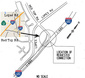 In October 2015, the CTC again approved for
future consideration of funding a project that will improve the
I-80/I-680/Route 12 Interchange, including relocation of the westbound
truck scales facility on I-80. For the preferred fullbuild alternative,
the current total estimated cost for capital and support is
$2,166,000,000. The project is not fully funded and will be developed in
phases. Only Phase One of the full-build alternative is included in the
financially constrained Regional Transportation Plan. Within Phase One,
the first construction contract’s total estimated cost for capital
and support is $100,400,000, which is funded by the 2012 State
Transportation Improvement Program, the Trade Corridor Improvement Fund
and local funding. Contract 1 of Phase One is currently under
construction. The design phase of Contract 2 of Phase One is 35% complete.
The scope of the first construction contract includes the reconstruction
of the Interstate 80/Green Valley Interchange and construction of a
two-lane westbound I-80 to westbound Route 12 Connector with a new bridge
over the I-80 Green Valley Road onramp. The scope of the preferred
alternative is consistent with the scope of the first construction
contract that is programmed in the 2012 State Transportation Improvement
Program and the Trade Corridor Improvement Fund. It was received again
because an Addendum had been completed due to changes in the project since
Commission approval of the Final Environmental Impacts Report (FEIR) in
2013.
In October 2015, the CTC again approved for
future consideration of funding a project that will improve the
I-80/I-680/Route 12 Interchange, including relocation of the westbound
truck scales facility on I-80. For the preferred fullbuild alternative,
the current total estimated cost for capital and support is
$2,166,000,000. The project is not fully funded and will be developed in
phases. Only Phase One of the full-build alternative is included in the
financially constrained Regional Transportation Plan. Within Phase One,
the first construction contract’s total estimated cost for capital
and support is $100,400,000, which is funded by the 2012 State
Transportation Improvement Program, the Trade Corridor Improvement Fund
and local funding. Contract 1 of Phase One is currently under
construction. The design phase of Contract 2 of Phase One is 35% complete.
The scope of the first construction contract includes the reconstruction
of the Interstate 80/Green Valley Interchange and construction of a
two-lane westbound I-80 to westbound Route 12 Connector with a new bridge
over the I-80 Green Valley Road onramp. The scope of the preferred
alternative is consistent with the scope of the first construction
contract that is programmed in the 2012 State Transportation Improvement
Program and the Trade Corridor Improvement Fund. It was received again
because an Addendum had been completed due to changes in the project since
Commission approval of the Final Environmental Impacts Report (FEIR) in
2013.
Additionally, in October 2015, the CTC approved a new public road connection to I-680 as a result of the I-80/I-680/Route 12 interchange project. The Interchange Project Report (04-0A5300) proposes to realign I-680 where it intersects I-80 and to construct a new interchange at I-680 and Red Top Road. The new I-680 alignment will tie into I-80 west of the current location at the intersection of Route 12 and I-80. A new interchange is proposed to be constructed at I-680/Red Top Road. The two ramps proposed include an entrance ramp from eastbound Red Top Road to southbound I-680 and an exit ramp with a structure over I-680 from northbound I-680 to westbound Red Top Road. The proposed project is intended to address numerous existing and future traffic-related problems while minimizing environmental impacts to sensitive habitat in the vicinity of the project, including the Suisun Marsh.
The 2018 STIP, approved at the CTC March 2018 meeting, appears to have allocated $9M in FY19-20 for PS&E for PPNO 5301X I-80/I-680/Route 12 Interchange - Package 2A
In May 2018, it was reported that the California
Transportation Commission approved $53 million for a project designed to
help eliminate the Route 12/Jameson Canyon bottleneck at I-80.
Construction to create a two-lane ramp from eastbound Route 12 to
eastbound I-80 could begin in 2020, Solano Transportation Authority
Executive Director Daryl Halls said. He estimated the project will cost
about $70 million, with the remaining money coming from other sources.
Caltrans in 2014 finished widening Route 12 from two to four lanes along
the six-mile Jameson Canyon segment. But the two eastbound lanes squeeze
down to one lane at the interchange ramp, causing backups that commuters
say can top a mile.
(Source: Napa Valley Register, 5/17/2018)
In June 2020, the CTC noticed a STIP amendment to
reprogram $16,700,000 in Regional Improvement Program (RIP) funds from the
Solano I-80 Managed Lanes project (PPNO 0658L) to the Solano
I-80/I-680/Route 12 Interchange – Package 2A project (PPNO 5301X) in
Solano County. The I-80/I-680/Route 12 project will replace the existing
single-lane eastbound Route 12 to eastbound I-80 connector structure with
a new two-lane structure that meets the operational requirements for the
ultimate configuration of this interchange. The project will also
construct direct ramps to Green Valley Road that will improve safety by
eliminating the existing weaving conflicts. The construction funding
plan for the project consists of Senate Bill (SB) 1 - Trade Corridor
Enhancement Program (TCEP) and Regional Measure (RM) 2 funds, and
construction is currently programmed in Fiscal Year 2019-20. The project
is being delivered using the Construction Manager/General Contractor
(CMGC) method of delivery. However, based upon the latest cost estimate,
the construction capital cost has been revised from $50,300,000 to
$67,000,000; which is an increase of $16,700,000. This increase is due to
the following reasons: (1) Geotechnical (Earthwork and structural
section): $8 Million — After the constructability review was
conducted, an extensive redesign was needed that resulted in significant
changes in quantities and upward revisions to unit prices. These
designchanges have increased the cost of the structural section by
$6,000,000. An additional $2,000,000 increase has resulted from more
extensive soil stabilization requiring longer piles and wick drains to
consolidate the unforeseen expansive and unstable soils at the abutment
locations. (2) Drainage: $4.2 Million — Based upon the final
design, new drainage system components are needed to better drain the flat
gradients surrounding the new roadway and to avoid conflicts with the
existing drainage systems. This includes two drainage crossings under the
I-80 that require an open trench on the west end and micro-tunneling at
the east end. (3) Traffic staging: $1.0 Million — The
original design details did not fully anticipate detour complexity and
resulting traffic staging challenges which require more extensive
construction signing/striping and traffic handling measures. The revised
estimate for temporary and permanent striping and staging requirements has
resulted in a cost increase of $1.0 million. (4) Specialty items: $3.5
Million — To address the revised trash capture requirements
from the Regional Water Quality Control Board, a large bioswale will be
constructed adjacent to the Green Valley Road off-ramp. Additional erosion
control measures are also needed to stabilize the embankments and cut
sections. Finally, the cost of median barrier has gone up as a result of
revised quantities and increase in unit prices. The amendment was approved
at the August 2020 meeting.
(Source: June 2020 CTC Agenda, Agenda Item
2.1b.(1); August 2020 CTC Agenda, Agenda Item 2.1a.(3))
The STA has been working with the Metropolitan
Transportation Commission to secure Regional Measure (RM) 3 funds to cover
the cost increase. However, because of still-unresolved litigation of RM3
funds, those funds are not available at this time. Therefore, the STA is
proposing to cover this funding shortfall by re-programming $16,700,000
RIP funds from the Solano I-80 Managed Lanes project (PPNO 0658L). The
Solano I-80 Managed Lanes project is currently programmed in the 2020 STIP
with $710,000 RIP for Right of Way and $33,290,000 RIP for
Construction; all funds programmed in 2021-22. The construction phase of
this project is not fully funded at this time. The STA and the Department
are planning to seek SB 1 funds during the upcoming cycle of SB 1 funding.
The STA is committed to fully fund this project using RM3 funds once the
litigation has been resolved. There are also minor changes in the project
limits, with the new limits being 04-Sol-80 11.4/12.8.
(Source: June 2020 CTC Agenda, Agenda Item
2.1b.(1))
In August 2020, the California Transportation
Commission (CTC) approved the allocation of $69,900,000 of funds for the
second phase of the I-80/I-680/Route 12 Interchange Project. The next
phase in the seven-phase project seeks to replace the existing single-lane
eastbound Route 12 connector to eastbound I-80 with a new two-lane
connector, in addition to constructing direct on and offramps from I-80 to
Green Valley Road in Fairfield. The project was financed through funds
from Senate Bill 1’s Trade Corridor Enhancement Program, State
Transportation Improvement Program as well as regional bridge toll funds.
It is expected to begin construction in September with the overall work
estimated to last two years.
(Source: August 2020 CTC Agenda, Agenda Item
2.5s.(5); The Reporter, 8/13/2020)
In October 2020, it was reported that construction has
begun on the estimated $77 million interchange project where I-80, I-680,
and Route 12 converge in Fairfield, a two-year effort that is expected to
improve traffic flow by configuring ramps and access to local streets.
Funded largely by Senate Bill 1, the project will replace the existing
single-lane eastbound Route 12 connector to eastbound I-80, a well-known
commuter bottleneck, with a new two-lane connector on a new alignment and
bridge structure that meets design requirements for the project’s
remaining phases. Additionally, the project will include the building of a
new slip ramp from eastbound Route 12 to Green Valley Road and a new
“braided” off-ramp from eastbound I-80.
(Source: Times Herald Online, 10/29/2020)
 In May 2021, it was reported that construction was in progress on the Route 12 / I-80
connector. While Route 12 through Jameson Canyon is two lanes in each
direction, that drops to one eastbound lane just before the freeway. A
one-lane connector ramp between highway and freeway is the culprit and a
two-lane ramp is the planned solution. Construction is currently replacing
that one-lane connector ramp bridge that curves over I-80. The new bridge
is expected to open in fall 2021, and the old bridge will be demolished.
Also in the works is a component sorting out the traffic streams heading
to eastbound I-80, Green Valley Road, and southbound I-680. They presently
crisscross as drivers jockey for position. So the plan is to have the
connector ramp split after crossing the freeway, with I-80-bound traffic
going one route and Green Valley Road-bound going another. Meanwhile,
still another route will carry eastbound I-80 traffic bound for Green
Valley Road and southbound I-680. Separating these traffic streams will
mean building a second, smaller bridge.
In May 2021, it was reported that construction was in progress on the Route 12 / I-80
connector. While Route 12 through Jameson Canyon is two lanes in each
direction, that drops to one eastbound lane just before the freeway. A
one-lane connector ramp between highway and freeway is the culprit and a
two-lane ramp is the planned solution. Construction is currently replacing
that one-lane connector ramp bridge that curves over I-80. The new bridge
is expected to open in fall 2021, and the old bridge will be demolished.
Also in the works is a component sorting out the traffic streams heading
to eastbound I-80, Green Valley Road, and southbound I-680. They presently
crisscross as drivers jockey for position. So the plan is to have the
connector ramp split after crossing the freeway, with I-80-bound traffic
going one route and Green Valley Road-bound going another. Meanwhile,
still another route will carry eastbound I-80 traffic bound for Green
Valley Road and southbound I-680. Separating these traffic streams will
mean building a second, smaller bridge.
(Source: $ Napa Valley Register, 5/6/2021)
Lastly, a change is coming to Red Top Road. This
currently ends in a T-intersection at Route 12 just before the connector
ramp. Vehicles turning left or right from Red Top Road onto the highway
must squeeze amid the traffic stream. As of 5/10/2021, Caltrans will close
the Red Top Road entrance onto Route 12 for safety reasons. Motorists will
be allowed to make a right turn from eastbound Route 12 onto Red Top Road.
However, the left-turn movement from northbound Red Top Road to westbound
Route 12 toward Napa County will be eliminated. Motorists are advised to
take eastbound I-80 to the Green Valley Road exit, cross over the freeway
and take the onramp to westbound I-80/westbound Route 12 toward Napa. When
all is done, eastbound Route 12 vehicles still might not always flow onto
I-80 without a stop. If I-80 has heavy traffic, a metering light will be
triggered along the connector ramp, similar to the one that is there
today.
(Source: $ Napa Valley Register, 5/6/2021; Patch.Com, 5/6/2021)
In August 2022, it was reported that the latest piece
of the massive I-80 / I-680 / Route 12 Interchange Project was completed
Monday with the opening of the eastbound I-80 to southbound I-680
connector ramp. State Department of Transportation crews re-opened the new
connector ramp to the traveling public. Motorists traveling eastbound on
Route 12 now have direct access to the southbound I-680 connector ramp,
including drivers who are traveling eastbound on I-80, Caltrans reported.
(Source: Solano Daily Republic, 8/3/2022)
In October 2022, it was reported that officials have
marked the completion of the latest portion of a massive project to revamp
the convergence in Fairfield of I-80, I-680 and Route 12: Completion of
the connector from EB Route 12 to EB I-80. The I-80/I-680/Route 12 project
is a multiple-year, multiple-phase effort near Fairfield’s Green
Valley and Cordelia Villages neighborhoods that includes Package 1 through
Package 7. Package 1 was completed in 2017 with a new Green Valley Road
Interchange and westbound Route 12 connector from westbound I-80 to
westbound Route 12 The just-completed phase of the project, known as
Package 2A, will improve the flow of traffic through the reconfiguration
of three freeway ramps at the interchange. It replaces the existing
single-lane eastbound Route 12 to eastbound I-80 connector with a new
two-lane connector and bridge structure, constructs a new off-ramp from
eastbound Route 12 to Green Valley Road, and creates a new off-ramp from
eastbound I-80 to Green Valley Road and southbound I-680.
(Source: Solano Daily Republic, 10/22/2022)
In July 2023, it was reported that in June 2023 MTC
last month formally approved the first allocations of Regional Measure 3
dollars, releasing over $270 million for nine projects for which the
sponsors already were moving ahead under Letters of No Prejudice. These
initial allocations included: Solano Transportation Authority: $70.4
million for work on the I-80 Express Lanes project between Cordelia and
Vacaville; $1.9 million to advance Phase II of the I-80/ I-680/Route 12
interchange reconfiguration; and $30.7 million for replacement and
relocation of the westbound I-80 truck scales.
(Source: MTG/ABAG Bay Link Blog, 7/12/2023)
 Commuter Lanes
In Contra Costa County, HOV lanes run northbound from 0.4 mi S of the Alcosta on-ramp to the Livorna on-ramp, for a length of 11.9 mies. Southbound, they run from 0.5 mi N of the Livorna on-ramp to 0.6 mi S of the Alcosta Blvd on-ramp, for a length of 12.6 mi. These lanes were opened in 1994 and extended in 1995. These lanes operate weekdays between 6:00am and 9:00am, and between 3:00pm and 6:00pm.
HOV lanes exist in Solano County on the Benicia/Martinez Bridge. These require three or more occupants, and operate weekdays between 5:00am and 10:00am, and between 3:00pm and 7:00pm.
HOV lanes exist from the Junction of I-580 and I-680 in Dublin to near Alamo. As part of the Route 24/I-680 junction rebuild that has been going on for two years, commute lanes will be extended to above the junction of I-680 and Route 242 just north of Walnut Creek (Marina Vista Drive). Construction starts in January 1999. New car-pool lanes along Interstate 680 from Center Avenue in Concord to North Main Street in Walnut Creek opened in 2004.
In November 2011, Caltrans opened a $1.9 million carpool lane extension from Rudgear Road in Walnut Creek to Livorna Road in Alamo. With this addition, the southbound carpool lane extends from Rudgear to the Alameda County line. The project was paid for with funds from the Measure J transportation sales tax in Contra Costa. The lane extension is a small part of a $49.8 million project to overhaul and repave I-680 in the San Ramon Valley and southern Walnut Creek.
There are also plans to add HOV lanes from Walnut Creek to Martinez (N Main Street to Marina Vista). [June 2002 CTC Agenda]
Naming Interstate 680 from Interstate 780 to
Interstate 80 in Solano County is named the "Luther E. Gibson Freeway"
(signed as "Luther Gibson Freeway"). Luther E. Gibson, State
Senator from 1949 to 1966, was a long time proponent of transportation
development and authored legislation which resulted in the construction of
the Carquinez Bridge and the Benecia-Martinez Span. It was named by Senate
Concurrent Resolution 21, Chapter 160 in 1967.
Interstate 680 from Interstate 780 to
Interstate 80 in Solano County is named the "Luther E. Gibson Freeway"
(signed as "Luther Gibson Freeway"). Luther E. Gibson, State
Senator from 1949 to 1966, was a long time proponent of transportation
development and authored legislation which resulted in the construction of
the Carquinez Bridge and the Benecia-Martinez Span. It was named by Senate
Concurrent Resolution 21, Chapter 160 in 1967.
(Image source: AARoads; Calisphere)
Interstate SubmissionsApproved as 139(a) non-chargeable mileage in 1973.
 Classified Landcaped Freeway
The following segments are designated as Classified Landscaped Freeway:
| County | Route | Starting PM | Ending PM |
| Santa Clara | 680 | M0.00 | M9.93 |
| Alameda | 680 | M0.00 | M2.85 |
| Alameda | 680 | M3.23 | M4.07 |
| Alameda | 680 | M5.11 | R6.62 |
| Alameda | 680 | 18.40 | 19.85 |
| Alameda | 680 | R20.42 | R21.88 |
| Contra Costa | 680 | R0.00 | R2.76 |
| Contra Costa | 680 | R3.02 | R3.74 |
| Contra Costa | 680 | R3.90 | R9.05 |
| Contra Costa | 680 | R9.22 | R12.05 |
| Contra Costa | 680 | R12.16 | 21.71 |
| Contra Costa | 680 | 22.48 | 22.81 |
| Contra Costa | 680 | 24.47 | 24.95 |
| Solano | 680 | 0.51 | M0.91* |
| Solano | 680 | M0.91 | R0.50 |
| Solano | 680 | R1.31 | R2.01 |
* Note: PM 0.51 is not the same thing as PM R0.50
 Exit Information
 Other WWW Links
 National Trails
 Portions of this route approximate the National Pony Express Trail, specifically the segments between Route 24 and Benecia, although
some segment veer of the current route onto older routings.
Portions of this route approximate the National Pony Express Trail, specifically the segments between Route 24 and Benecia, although
some segment veer of the current route onto older routings.
 Blue Star Memorial Highway
The portion of this route from the Alameda county line to the Benicia-Martinez Bridge was designated as a "Blue Star Memorial Highway" by Senate Concurrent Resolution 38, Ch. 175 in 1970.
Freeway[SHC 253.1] Entire route. Added to the Freeway and Expressway system in 1959.
 Statistics
Overall statistics for Route 680:
© 1996-2020 Daniel P. Faigin.
Maintained by: Daniel P. Faigin
<webmaster@cahighways.org>.
 Route 605
 Route 710