
 California Highways:
Click here for a key to the symbols used. An explanation of acronyms may be found at the bottom of the page.
 Routing
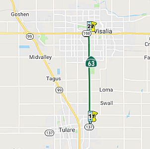 From Route 137 near Tulare to Route 198.
 Post 1964 Signage History
This segment remains as defined in 1963.
 Pre 1964 Signage History
By 1953, this route was signed as Route 63. It was part of LRN 132, defined in 1933.
Prior to the 1964 renumbering, Route 63 was signed on LRN 134 (now Route 137) from LRN 4 (US 99) east a short distance to LRN 132*,
north on LRN 132 to LRN 130 near Orosi, and then east on LRN 130 to LRN 129 (SSR 65). Post-renumbering: the "stub" of LRN 132 from Orosi to Orange
Cove was indeed new Route 226, but was never signed as such; the '65
renumbering put the kibosh on that. Route 63 continued to be signed over
the short section of new Route 137 for about a year and a half; Route 137
signage was erected over the summer of '65, truncating Route 63 to the
Route 63/Route 137 interchange east of Tulare (although it appears based
on definitions that the portion signed as Route 63 was also still Route 137). Curiously, the Paige Avenue exit on Route 99 (south of the Route 99/Route 137 interchange in central Tulare) was marked as "TO CA 63" on
the exit's BGS during the late '60's, since taking Paige east from the
exit for about a half-mile brought one to Mooney Blvd., the local
extension of Route 63. That signage disappeared around 1970, with no
further mention of Route 63 anywhere along Route 99.
The route was not signed as part of the 1934 state highway signage; however, it was signed by 1958 as demonstrated by a picture at Aaroads.
 Status
In May 2014, the CTC authorized relinquishment of right of way in the county of Tulare along Route 63 on Avenue 256 (Oakdale Avenue) (~ TUL 3.007), consisting of a reconstructed county road. The County, by relinquishment agreement dated May 14, 2012, waived the 90-day notice requirement and agreed to accept title upon relinquishment by the State.
In August 2014, the CTC authorized relinquishment of right of way in the city of Visalia along Route 63 (Mooney Boulevard) on Whitendale, Walnut, and Tulare Avenues (~ TUL 6.517 to TUL 7.505), consisting of reconstructed city streets. The City, by relinquishment agreement dated May 9, 2014, waived the 90-day notice requirement and agreed to accept title upon relinquishment by the State.
 Naming
 The 1.6 mile portion of Route 63, also known as South Mooney Boulevard, from
Avenue 264 to West Visalia Parkway in Visalia (~ TUL 4.024 to TUL 6.004)
is named the "Greatest Generation Memorial Highway" It was named in
honor of Visalia's "Greatest Generation", a term used to refer to World
War II veterans. Over 413,000 Americans gave their lives to preserve our
liberty and freedom during this conflict that ended on August 15, 1945.
Visalians were involved abroad in Europe, the Pacific, and at home in
contributing towards the eventual victory of the United States. The City
of Visalia made a significant contribution to the United States war effort
through leasing the Visalia Municipal Airport to the United States Army,
which conducted significant operations, including air submarine patrols,
at the renamed Visalia Army Air field. The Greatest Generation World War
II mural, which is 72 feet wide and 19 feet high and depicts and
symbolizes events and people throughout the war, is located at 26572 South
Mooney Boulevard, also known as Route 63. Named by Assembly Concurrent
Resolution (ACR) 36, Resolution Chapter 78, on 7/17/2009.
The 1.6 mile portion of Route 63, also known as South Mooney Boulevard, from
Avenue 264 to West Visalia Parkway in Visalia (~ TUL 4.024 to TUL 6.004)
is named the "Greatest Generation Memorial Highway" It was named in
honor of Visalia's "Greatest Generation", a term used to refer to World
War II veterans. Over 413,000 Americans gave their lives to preserve our
liberty and freedom during this conflict that ended on August 15, 1945.
Visalians were involved abroad in Europe, the Pacific, and at home in
contributing towards the eventual victory of the United States. The City
of Visalia made a significant contribution to the United States war effort
through leasing the Visalia Municipal Airport to the United States Army,
which conducted significant operations, including air submarine patrols,
at the renamed Visalia Army Air field. The Greatest Generation World War
II mural, which is 72 feet wide and 19 feet high and depicts and
symbolizes events and people throughout the war, is located at 26572 South
Mooney Boulevard, also known as Route 63. Named by Assembly Concurrent
Resolution (ACR) 36, Resolution Chapter 78, on 7/17/2009.
(Image source: Waymarking)
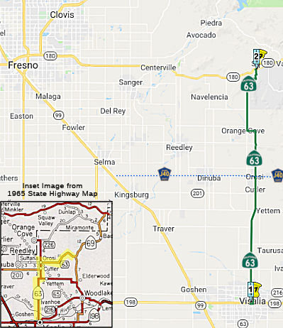 From Route 198 to Route 180 via the vicinity of Orosi and
Orange Cove.
From Route 198 to Route 180 via the vicinity of Orosi and
Orange Cove.
Post 1964 Signage HistoryIn 1963, this segment was defined to be "Route 198 to Route 69 via Orosi.". Route 69 was later renumbered as Route 245.
In 1965, Chapter 1372 deleted the portion (former LRN 130) from Orosi to
Route 69 (present-day Route 245), and transferred the portion of former
Route 226 (also part of LRN 132) from Orosi to Orange Cove to Route 63. It
also transferred a portion of County Sign Route J19 from Orange Cove to Route 180 to the
route, making the segment "Route 198 to Route 180 via the vicinity of
Orosi and Orange Cove." The deleted portion is now County Sign Route J40, also known as
Avenue 416 and Boyd Drive. There is a photo essay on Boyd Drive on the Gribblenation blog.
(Sources: AARoads, January-September 2017; Gibblenation Blog, "CaliforniaState
Route 63")
Pre 1964 Signage HistoryBy 1953, the segment of this route from Route 198 to Orosi was signed as Route 63. This segment was part of LRN 132. Note that prior to 1964, Route 63 was cosigned with Route 198 in Visalia (and LRN 10 was concurrent with LRN 132). According to Tom Fearer on Gribblenation, Route 63 shows up first as a signed route on the 1950 state highway map, but only on the LRN 132 portion. The LRN 130 portion isn't signed on the 1950 map, but is signed on the 1950 topographical map.
The former segment between Orosi an General Grant Park (Pre-1964 Route 65, renumbered to Route 69, and then renumbered to current Route 245) was LRN 130. This segment first shows up as a state signed route on the state highway map in 1956, per Gribblenation. It is now County Sign Route J40.
The portion from Orosi to Orange Cove was also LRN 132, defined in 1933 (and was signed as Route 226 post 1964).
The portion from Orange Cove to Route 180 is new routing.
Route 63 was not defined as part of the initial state signage of routes in 1934. It is unclear what (if any) route was signed as Route 63 between 1934 and 1953.
StatusIn December 2019, it was reported that the Visalia City Council
considered whether to request Caltrans to relinquish Route 63 along Court
and Locust Street (TUL 8.023L/TUL 8.717L (Locust) and TUL 8.02R/TUL R8.78R
(Court), and they concluded that having a state highway run through your
downtown may not be ideal but it’s cheaper than maintaining it
yourself. Councilmember Greg Collins asked the council to discuss a
request that the State of California relinquish the northern portion of
Route 63 to the city. Councilmember Greg Collins asked the council to
discuss the issue, as state control of Route 63 through downtown has
created a number of ongoing issues, including higher speed limits,
bureaucracy of encroachments, and that the State won’t allow for
certain improvements, such as bulb outs or planting of trees at
intersections to slow traffic and make the downtown more pedestrian
friendly. Collins also said taking back responsibility for the roadway
would mean an opportunity to establish additional parking. Vice Mayor
Steve Nelsen, who also serves as president of the Downtown Visalians, said
most property owners he talked to were not in favor of the proposal and
that they were “fine with the way it is.” Councilman Phil Cox
pointed out that the city would also lose the majority of funding for
maintenance of traffic signals on Court Street and Locust Street provided
by CalTrans.
(Source: Visalia Sun Gazette, 12/18/2019)
In March 2011, the CTC authorized relinquishment of right of way in the county of Tulare along Route 63, on Avenue 408 (~ TUL 22.578), consisting of collateral facilities.
 Freeway
[SHC 253.1] Entire route. Added to the Freeway and Expressway system in 1959.
 Interregional Route
[SHC 164.13] Between the north urban limits of Visalia and Route 180.
 Other WWW Links
 Statistics
Overall statistics for Route 63:
 Pre-1964 Legislative Route
The route that would become LRN 63 was first defined in the 1919 Third Bond Act as running from Big Pine to Oasis.
In 1931, Chapter 82 extended the route from Oasis to California-Nevada State Line. The rationale was closing the 2½ mi gap over Fish Lake Valley to bring the route to the California-Nevada state line, where a Nevada state highway proceeds northeasterly. Inclusion of this short section as a State highway closed the gap between the California and Nevada highway systems, and provided a complete interstate connection and corrected an obvious error in State highway designation.
In 1935, the route was codified into the highway code as the route:
From Big Pine to the Nevada State Line via Oasis
This definition remained unchanged utnil the 1963 renumbering. It is present-day Route 168 to Oasis, and Route 266 from Oasis to the Nevada state line.
© 1996-2020 Daniel P. Faigin.
Maintained by: Daniel P. Faigin
<webmaster@cahighways.org>.
 Route 62
 Route 64