
 California Highways:
Click here for a key to the symbols used. An explanation of acronyms may be found at the bottom of the page.
 Routing
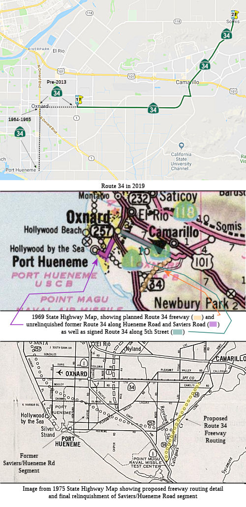 From Rice Avenue in the City of Oxnard to Route 118 near
Somis.
From Rice Avenue in the City of Oxnard to Route 118 near
Somis.
The relinquished former portions of Route 34 within the City of Oxnard are not state highways and are not eligible for adoption under Section 81. For those relinquished former portions of Route 34, the City of Oxnard shall maintain within its jurisdiction signs directing motorists to the continuation of Route 34.
 Post 1964 Signage History
In 1963, Route 34 was defined as the route "from Port Hueneme to Route 118 near Somis.". This included the routing along Hueneme Road and Saviers Road to Route 1
In 1965, the portion from Port Hueneme to Route 1 was legislatively
deleted, changing the definition to "from Route 1 between Point Mugu
and the City of Oxnard Port Hueneme to Route 118 near
Somis.". For the existing signed route, this technically removed
the portion of the route on Hueneme Road and Saviers Road, truncating the
route to start at Route 1 at 5th Street and Oxnard Boulevard1.
However, that deleted portion remained on the state highway maps until at
least 1970, disappearing by the 1975 map. Quite likely, what happened is
that it took until the early 1970s to relinquish the route to the local
entities, and so it remained as signed Route 34, and was state maintained,
even though it was no longer part of the official definition (think
something along the lines of Route 34U). But the state highway maps since
1965 also show a new alignment (likely a freeway alignment) running from
the curve in 5th Street near Pleasant Valley Road diagonally parallel to
Lewis Road, Las Posas, and Hueneme Road to Point Mugu. That alignment
(unbuilt) remained on the books until the the late 2000 relinquishments,
and was officially deleted in the 2014 change in the legislative
definition.2
(1 Source: Gribblenation "California State Route 34" (Tom Fearer), 8/11/2019; 2 DPF research triggered by Gribblenation)
However, the above is more confusing, as it is unclear if the routing along Saviers Road was part of Route 34, or it was a routing along Wood Road ... and the role of Hueneme Road is unclear.
In 2008, SB 1366, Chapter 717, September 30, 2008, authorized the relinquishment of the portion of the route within the city limits of Oxnard:
The commission may relinquish to the City of Oxnard the portion of Route 34 that is located within the city limits of that city and is between Oxnard Boulevard and Rice Avenue, upon terms and conditions the commission finds to be in the best interests of the state, if the commission and the city enter into an agreement providing for that relinquishment. (1) A relinquishment under this subdivision shall become effective immediately after the county recorder records the relinquishment resolution that contains the commission's approval of the terms and conditions of the relinquishment. (2) On and after the effective date of the relinquishment, that portion of Route 34 relinquished shall cease to be a state highway and may not be considered for future adoption under Section 81. (3) For portions of Route 34 relinquished under this subdivision, the City of Oxnard shall maintain within its jurisdiction signs directing motorists to the continuation of Route 34.
In March 2013, the CTC relinquished right of way in the city of Oxnard on Route 34 from Oxnard Boulevard (Route 1) to Rice Avenue, under terms and conditions as stated in the relinquishment agreement, determined to be in the best interest of the State. Authorized by Chapter 717, Statutes of 2008, which amended Section 334 of the Streets and Highways Code.
In 2014, AB 2752 (Chapter 345, 9/15/2014) changed the starting point of
the route to Rice Avenue [From Route 1 between Point Mugu andRice
Avenue
in the City of Oxnard to Route 118 near Somis], reflecting the
relinquishment in the city of Oxnard. As a result, much of item (b) was
deleted, leaving only:
(b) The relinquished former portions of Route 34 within the City of Oxnard are not state highways and are not eligible for adoption under Section 81. For those relinquished former portions of Route 34, the City of Oxnard shall maintain within its jurisdiction signs directing motorists to the continuation of Route 34.
A discussion of the Highways to Boulevards program during the March 2022
CTC meeting identified the following segment(s) as potential Highways to
Boulevards conversion projects: Route 34 (Lewis Road) from Ventura
Boulevard (~ VEN R13.53) to Pleasant Valley Road (~ VEN 12.774) in
Camarillo
(Source: March 2022 CTC Agenda, Agenda Item 4.3)
 Pre 1964 Signage History
This route was LRN 153, defined in 1933, running from Hueneme to LRN 9 (Route 118) near Somis. Route 34 was not included in the original set of signed state routes in 1934. It is unclear when this routing was first signed as Route 34.
Tom Fearer believes the original definition of LRN 153 (Route 34) began
at Port Hueneme on Hueneme Road and swung north into Oxnard via Saviers
Road. LRN 153 multiplexed LRN 60 (future Route 3 and US 101A) on Oxnard
Boulevard to 5th Street. From 5th Street the route of LRN 153 is almost
identical eastward to Somis as modern Route 34. The original alignment of
LRN 153 can be seen on the 1935 Division of Highways Map of Ventura
County.
(Source: Gribblenation "California State Route 34" (Tom Fearer), 8/11/2019)
However, a 1942 USGS map shows what is now Route 34 running along Somis Road (Lewis) from Sign Route 118 to Pleasant Valley and 5th to Wood Road -- as Sign Route 118 (which would have to be a spur route). That spur of Sign Route 118 continues down Wood Road to US 101A. This shows on a 1943 map as well, but not later. LRN 154 ran along Hueneme Road swinging N into Oxnard on Saviers Road, which may have been LRN 154. LRN 154 also ran along Vineyard to Sign Route 118. These LRN 154 segments were seemingly signed as a spur of Sign Route 126.
 Status
There are plans to widen this route in the city of Camarillo (August 2002 CTC Agenda).
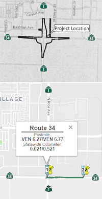
Rice Avenue Grade Separation (VEN 6.27/6.77)
 The SAFETEA-LU act, enacted in August 2005 as the reauthorization of TEA-21, provided the following
expenditures on or near this route:
The SAFETEA-LU act, enacted in August 2005 as the reauthorization of TEA-21, provided the following
expenditures on or near this route:
In May 2018, it was reported that the CTC approved SB1
funding for a bridge on Rice Avenue over Route 34 and railroad tracks.
(Source: Caltrans District 7 Tweet, 5/23/2018)
In June 2018, the CTC approved for future consideration
of funding: 07-Ven-34, PM 6.27/6.77 On Route 34: Rice Avenue Grade
Separation Project: Construct a grade separation structure at an existing
intersection of Rice Avenue and Fifth Street in Ventura County. (FEIR)
(PPNO 4961) (TCEP). This project is located at the Rice Avenue Grade
Separation in the city of Oxnard in Ventura County. The project proposes
to construct a grade separation at the existing Rice Avenue and Fifth
Street intersection. The project proposes to eliminate an existing
at-grade railroad crossing. The purpose and need of the proposed project
is to eliminate the conflict between vehicles and trains at the
railhighway crossing and to address future traffic and circulation issues
forecasted for the project area. The proposed project is estimated to cost
$79.2 million. The project is currently programmed for $81.2 million in
the Senate Bill Trade Corridor Enhancement Program (TCEP), Regional
Surface Transportation Program, Federal and Local programs. This project
is determined to be a Delegated Project under the Federal Highway
Administration (FHWA) and to be administered per the Project
Responsibilities List in the Joint Stewardship and Oversight Agreement
between FHWA and the California State Department of Transportation. The
project is estimated to begin construction in 2020. The scope, as
described for the preferred alternative, is consistent with the project
scope programmed by the Commission in the TCEP.
(Source: CTC Agenda, June 2018 Agenda Item 2.2c(23))
In December 2019, the CTC had on its agenda a request to amend the TCEP Project Scope for the Rice Avenue & Fifth Street Grade Separation project, in Ventura County, to update the baseline agreement, benefits, project delivery schedule, preconstruction and construction costs. The Rice Avenue & Fifth Street Grade Separation project will construct a grade separation at the intersection of Route 34/Fifth Street and Rice Avenue in the city of Oxnard. Union Pacific Railroad tracks run parallel to Route 34/Fifth Street, and the grade separation will elevate Rice Avenue over both Route 34/Fifth Street and the railroad crossing. The project will eliminate conflict between vehicles and trains at the rail-highway crossing, improve the flow of truck traffic to the Port of Hueneme, and increase safety by eliminating the at-grade crossing. This intersection ranks second on the California Public Utilities Commission (CPUC) Priority List which establishes priority projects for eliminating or altering hazardous railroad crossings.
The current approved scope for the grade separation, alternative 2A, includes the construction of two connector roads, one in the southeast quadrant and another in the southwest quadrant of the Rice Avenue grade separation, to provide access between Rice Avenue and Route 34/Fifth Street. It also includes traffic signals for both connectors, new sidewalk, and bicycle lanes. During the design phase of alternative 2A, additional information from utility companies became available which modified the original utility assumptions performed in 2017. Utility relocation cost assumptions made during the original estimates were assumed to be lower and relocation costs covered by utility companies. In January 2019, six months into the PS&E phase for alternative 2A, utility companies provided prior rights easement documents, cost estimates for relocations, and preliminary plans, which were higher than original utility relocation cost estimates. Utility companies provided more complete data on costs to prepare relocation plans, administer, inspect, and have their facilities relocated. Cost estimates provided by each utility company were not available at the time of TCEP application. As a result, the cost estimate for the utility relocations have been adjusted accordingly. In addition, estimates for property acquired through condemnation also have undergone revised fair market value analysis. The cost estimate provided in the Project Report for RW acquisition was based on price for prior sale per square footage. Although the possibility of condemnation was known at the time of the TCEP application, there was still a strong possibility it would not be required in which case the acquisition could have been done by the County of Ventura, and that is what the original cost and schedule was based upon. When the likelihood of condemnation became more apparent, it became necessary to transfer the lead for RW to the Department. Property acquisition requires a complete eminent domain process. Additional time is required to obtain permits to enter from the property owners through writ of assistance (3-4 months); the time it takes (3-4 months) for collecting soil samples including, testing, analyzing and completing the hazardous waste investigation report; and a longer timeline for the property owners to respond to written offers. The original schedule did not foresee this longer timeline.
To partially mitigate these cost increases, it is
proposed to change the preferred design from alternative 2A to alternative
3B; shifting the alignment of Rice Avenue 250 feet to the east and
eliminating one connector ramp. This new design, alternative 3B, was
considered during the environmental phase, but Alternative 2A was
preferred before the additional costs were known. Under alternative 3B,
the southwest connector road is eliminated, and traffic signals are
relocated. Both alternative 2A and 3B include two traffic signals. New
sidewalk outputs will change from 10,600 feet to 8,700 feet under the new
alternative 3B, due to the elimination of the southwest connector ramp.
Bicycle lane outputs will remain unchanged under the new alternative 3B,
remaining at 7,400 feet. The project will be programmed in FY22-23.
(Source: December 2019 CTC Agenda, Agenda Item
2.1s.(1))
Also in December 2019, the CTC had this project its
agenda for future consideration of funding: 07-Ven-34, PM 6.27/6.77 Route 34 in Ventura County. Construct a grade separation on Route 34 at Rice
Avenue in the city of Oxnard in Ventura County. (PPNO 4961). This project
is located at the Rice Avenue/Fifth Street (Route 34)/Union Pacific
Railroad (UPRR) track intersection in Ventura County. The project proposes
to construct a grade separation on Rice Avenue where it crosses over Route 34 and the UPRR. The proposed project addresses the need to reduce
conflict between vehicles and trains as well as future traffic and
circulation issues forecasted for the project area. The project also
proposes to construct two connector roads. This project is fully funded
and is currently programmed in the 2018 STIP for $79.2 million with plans
to increase programmed funding. Construction is estimated to begin in
2022.
(Source: December 2019 CTC Agenda, Agenda Item
2.2c.(8))
In June 2023, the CTC approved for future consideration
of funding 07-Ven-34, PM 6.27/6.77. Rice Avenue Grade Separation
Project. Construct a grade separation structure at the existing
Rice Avenue (Route 34) and Fifth Street intersection, in Ventura County.
(FEIR Addendum) (PPNO 4961) (TCEP). The project is located on Route 34
from postmile 6.27 to postmile 6.77, in Ventura County. The Department
proposes to construct grade separation structure to elevate Rice Avenue
over SR 34 and the Union Pacific Railroad track to eliminate the existing
at-grade railroad crossing. The project also includes the construction of
a connector ramp, in the southeast quadrant of the Rice Avenue grade
separation, to provide access between Rice Avenue and Fifth Street/Route 34. The project is currently programmed in the 2018 TCEP for a total of
$117,532,000, which includes Right of Way (Capital) and Construction
(Capital). Construction began 2020-21. The scope, as described for the
preferred alternative, is consistent with the project scope as programmed
by the Commission in the 2018 TCEP. A copy of the FEIR has been provided
to Commission staff. The Commission approved the project for future
consideration of funding on December 4, 2019, under Resolution E-19-105.
The Project Development Team (PDT) determined that the cost of
constructing Alternative 2A would be too high and infeasible due to the
amount of utility relocations, ROW acquisition, and construction of a
temporary detour road. The PDT has decided to move forward with
Alternative 3B to save project costs by reducing utility relocations, ROW
acquisition, farmland acquisition, and eliminating retaining walls and the
temporary detour road. The Department subsequently completed an Addendum
to the FEIR pursuant to CEQA. The Department has approved this project for
construction. This approval and Addendum will satisfy the environmental
requirements for this stage of the planning process.
(Source: June 2023 CTC Agenda, Agenda Item 2.2c.(2) Item 8)
Somis Reconstruction (VEN 17.637)
![[118/34 Jct]](maps/118-somis.jpg) In February 2009, the CTC
received notice of preparation of an EIR for reconstruction of the Route 118/Route 34 interchange in Somis. The proposed project would construct
roadway improvements that include relocating and realigning Route 118 at
Donlan Road, and adding a westbound left-turn lane in the westbound
direction of Route 118, an eastbound auxillary lane, and interchange ramp
improvements along portions of Route 118 and Route 34 intersection in the
community of Somis in Ventura County. The project is included in the State
Highway Operation and Protection Program Long Lead Project List. Future
funding for project design, right of way, and construction will be
programmed later pending completion of the environmental clearance. The
alternatives being considered are:
In February 2009, the CTC
received notice of preparation of an EIR for reconstruction of the Route 118/Route 34 interchange in Somis. The proposed project would construct
roadway improvements that include relocating and realigning Route 118 at
Donlan Road, and adding a westbound left-turn lane in the westbound
direction of Route 118, an eastbound auxillary lane, and interchange ramp
improvements along portions of Route 118 and Route 34 intersection in the
community of Somis in Ventura County. The project is included in the State
Highway Operation and Protection Program Long Lead Project List. Future
funding for project design, right of way, and construction will be
programmed later pending completion of the environmental clearance. The
alternatives being considered are:
Moorpark officials reviewed the draft EIR, and believe that it fails to take into account a plan by Ventura County to realign Donlon Road so that it joins to make a four-way intersection where the two state highways meet. They also believe that it does not provide mitigation of an expected increase in truck traffic and related air quality, noise and safety impacts on Route 118 as a result of projects planned by Caltrans.
In October 2012, it was reported that Caltrans has dropped plans to revamp the Somis interchange. Caltrans will include its decision in the project's environmental impact report that will be issued by the end of November 2012. The county now wants to realign Donlon to make a four-way intersection at Route 118 and Somis Road. According to the county, Caltrans can make "easy, quick and cheap fixes" in conjunction with the county project, such as lengthening a left-turn lane from westbound Route 118 to Somis Road.
 Naming
Evidentally, Route 34 (while still just LRN 153) was planned to be the "Calleguas Freeway", according to a 1962 California F&E map for Ventura County.
 Freeway
[SHC 253.1] Entire route (never upgraded). This was added to the Freeway and Expressway system in 1959.
 Other WWW Links
 Statistics
Overall statistics for Route 34:
 Pre-1964 Legislative Route
The route that was to become LRN 34 was first defined in the 1909 First Bond Issue as running from [LRN 4] near Arno to Jackson. In 1911, the definition of the Alpine State Highway extended LRN 34 with the segments from Route 99 to Route 88 SE of Ione and from Route 104 to Route 89:
"The certain road commencing at the Calaveras big tree grove located in Calaveras County thence running to Dorrington in said county, thence E-ly following what is known as the Big Tree and Carson Valley Turnpike to Mt. Bullion in Alpine Cty, thence along county road to Markleeville in Alpine Cty, thence along that certain road via Kirkwood, Silver Lake, Pine Grove and Irishtown to Jackson in Amador Cty, including therewith the road from Picketts in Hope Valley connecting with the Lake Tahoe Wagon Road, a state highway, at Osgood's Place in El Dorado Cty, and the road from Mt Bullion via Loupe in Alpine Cty to Junction in Mono County connecting with the Sonora and Mono State Highway is hereby declared and established a state highway and shall be designated and known as "Alpine State Highway""
This led to its 1935 definition as:
[LRN 4] near Arno to [LRN 23] near Pickett's in Hope Valley via Jackson, Irishtown, Pine Grove, Silver Lake, and Kirkwood.
This was primary state highway from Arno to Jackson.
This definition remained intact until the 1963 renumbering. It was signed as Route 104 between cosigned US 50/US 99 (present-day Route 99) to 2 mi SE of Ione, and as Route 88 (originally Route 8, until around 1948) between 2 mi SE of Ione and Route 89 (LRN 23) near Pickett's.
© 1996-2020 Daniel P. Faigin.
Maintained by: Daniel P. Faigin
<webmaster@cahighways.org>.
 Route 33
 Route 35