
 California Highways:
Click here for a key to the symbols used. An explanation of acronyms may be found at the bottom of the page.
 Routing
 From Route 99 near Stockton to Route 49 passing south of Ione.
 Post 1964 Signage History
This segment remains as defined in 1963.
 Pre 1964 Signage History
This is LRN 97, defined in 1933. It was not signed as Route 88 as part of the initial state highway routing, but was signed by the early 1940s.
 In 1953, it was reported that a change was being made in how Route 88
connected to Route 12. The CHC had approved the new connection, and
contractors were bidding to construct the new segment. Originally, Route 88 ran along Mackville Road and Collier Road E. This was replaced with a
new direct connection. The new location for Route 88 is a 1.4 mi section,
and includes a new concrete reinforced bridge. At the same time, work was
being performed to realign the existing Route 12 in this area, eliminating
sharper curves and rolling grades, reconstructing the highway as a modern
two-lane roadway using the existing road as a base where possible.
In 1953, it was reported that a change was being made in how Route 88
connected to Route 12. The CHC had approved the new connection, and
contractors were bidding to construct the new segment. Originally, Route 88 ran along Mackville Road and Collier Road E. This was replaced with a
new direct connection. The new location for Route 88 is a 1.4 mi section,
and includes a new concrete reinforced bridge. At the same time, work was
being performed to realign the existing Route 12 in this area, eliminating
sharper curves and rolling grades, reconstructing the highway as a modern
two-lane roadway using the existing road as a base where possible.
(Source: Unnamed publication, 11.20/1953, via Joel Windmiller,
2/6/2023)
Tom Fearer noted that Route 104 was a post 1964 route created from parts
of the original Route 104 alignment and LRN 97. Originally it was Route 104 that ran north to Route 16 instead of it running through downtown Ione
eastward via what was an unsigned portion of LRN 34 to Route 88. The state
highway south of Ione was an unsigned part of LRN 97, for some reason the
route north out of Ione still shows as a Route 104 but LRN 124 in 1964 but
it finally shows the signage change by 1965. Really the realignment of
Route 104 made sense since the route took a pretty wild north/south swing
after being almost entirely east/west. The 1935 Amador County Map shows
LRN 97 running to Ione on Dave Brubeck Road and maybe Marlette Street then
using what became LRN 34 to continue eastward to Jackson. That would
certainly explain what the thinking was with Route 104 in the early signed
highway era. By 1940 the state highway map shows Route 88 coming to Ione.
By 1955, Route 88 is still shown going through Ione but using part of the
modern highway which can be seen changing from 1954. In 1960, Route 88 is
shown shifting completely south of Ione in 1960.
(Source: Tom Fearer/Max R. on AARoads, "CA 124", June 2017)
In the same thread, Scott Parker noted that Ione has always been something of a mess. Originally LRN 34 east of Jackson was signed as Route 8; this continued into Alpine County and out into Nevada (along present Route 88). Route 104 remained on LRN 34 from Ione to Route 49 just north of Jackson, where it terminated. In 1939 it was decided to terminate Route 8 in Jackson (the longstanding multiplex on Route 49 from Mokelumne Hill to Jackson remained intact); a new route, Route 88, was commissioned over all of LRN 34 east of Ione and over LRN 97 southwest of there to Stockton. Instead of terminating Route 104 at new Route 88 in Ione, it was redirected north over the remainder of LRN 97 to terminate at Route 16 west of Route 49; this left a few blocks of state-maintained LRN 34/LRN 97 in Ione unsigned, but (apparently; I've never seen specific evidence published) with "trailblazer"/"TO" signage from each of the separate signed alignments. This arrangement persisted until 1959, when the "88 Connector" south of Ione was built; technically a spur of LRN 97. Signage was simple: from EB Route 88, the LRN 97 (west) turnoff was signed "Ione" (with an arrow on a BBS), with an attached "TO"/"Route 104" shield array; the LRN 34 (east) turnoff was likewise signed WB only. Within Ione proper, the intersection where Route 104 turned from east to north was signed "TO Route 88"; once the LRN 34/LRN 97 "split" was reached in downtown Ione, trailblazers reading "TO EAST Route 88" and "TO WEST Route 88" were posted. The '64 renumbering cleared things up considerably. Actual signage (Route 104, Route 124) was now posted on the connectors, with Route 104 on the previous LRN 34 and Route 124 on LRN 97. Also at that time the connection (now on Route 124) north to Route 16 was realigned east of its previous track; it now intersected Route 16 only a half-mile west of that route's eastern terminus at Route 49 near Plymouth. The new alignment was (and is) definitely a 2-lane CA-type "expressway", with very limited side access. Presently Ione still maintains its historic "old gold rush village" demeanor downtown, but there's a lot of modern housing around the town's perimeter (including a lot of second homes for Sacramento and Stockton residents).
Tom Fearer (Max R) has a nice travelogue on Route 88, including quite a lot of history of the routing.
 Status
In September 2012, the CTC relinquished right of way in the county of San Joaquin along Route 88 on Baker and Pezzi Roads (~ SJ 4.382), consisting of collateral facilities.
In August 2011, the CTC approved $3,200,000 in SHOPP funding for repairs near Lodi, from Comstock Road (~ SJ 4.914) to Route 12 (~ SJ L12.276), that will rehabilitate 14 miles of pavement to improve safety and ride quality.
Liberty Road Roundabout (10-SJ-88 PM 22.1)
 In October 2018, the CTC approved for for future consideration of funding the following project
for which a Mitigated Negative Declaration (MND) has been completed: Route 88 in San Joaquin County (10-SJ-88, PM 22.09). Construct a new roundabout
on Route 88 at Liberty Road near the town of Clements. (PPNO 3207) This
project is located at the Liberty Road and the Route 88 intersection near
Clements in San Joaquin County. This project proposes to improve the
safety of the intersection with the construction of a single lane rural
roundabout. The proposed project addresses the need to reduce the number
and severity of broadside collisions at this intersection in which the
total accident rate is higher than the statewide average. The proposed
project is currently estimated to cost approximately $10.0 million. This
project is fully funded and is currently programmed in the 2018 SHOPP for
approximately $9.9 million which includes Construction (capital and
support) and Right-of -Way (capital and support). Construction is
estimated to begin in 2020. The scope, as described for the preferred
alternative, is consistent with the project scope programmed by the
Commission in the 2018 SHOPP. In Agenda Item 2.5b.(2a), they provided a
support allocation of PA&ED $1,390,000.
In October 2018, the CTC approved for for future consideration of funding the following project
for which a Mitigated Negative Declaration (MND) has been completed: Route 88 in San Joaquin County (10-SJ-88, PM 22.09). Construct a new roundabout
on Route 88 at Liberty Road near the town of Clements. (PPNO 3207) This
project is located at the Liberty Road and the Route 88 intersection near
Clements in San Joaquin County. This project proposes to improve the
safety of the intersection with the construction of a single lane rural
roundabout. The proposed project addresses the need to reduce the number
and severity of broadside collisions at this intersection in which the
total accident rate is higher than the statewide average. The proposed
project is currently estimated to cost approximately $10.0 million. This
project is fully funded and is currently programmed in the 2018 SHOPP for
approximately $9.9 million which includes Construction (capital and
support) and Right-of -Way (capital and support). Construction is
estimated to begin in 2020. The scope, as described for the preferred
alternative, is consistent with the project scope programmed by the
Commission in the 2018 SHOPP. In Agenda Item 2.5b.(2a), they provided a
support allocation of PA&ED $1,390,000.
(Source: October 2018 CTC Agenda Item 2.2c.(1);
Image source: The PineTree, 6/10/2021)
In August 2020, the CTC received notice of the
following delegated allocation: $5,023,000. 10-SJ-88 PM 22.1. PPNO 10-3207
ProjID 1016000031 EA 1E531. On Route 88 Near Clements, at Liberty Road.
Outcome/Output: Improve safety and operations by constructing a single
lane roundabout. This project will reduce the number and severity of
collisions.
(Source: August 2020 CTC Agenda, Agenda Item
2.5f.(3) #9)
In June 2021, it was reported that Caltrans was
starting construction on a roundabout at Route 88 and Liberty Road.
Construction will continue into fall 2021. Crews will install a
single-lane, rural traffic circle to replace an intersection that has two
stop signs at Liberty Road and free-flowing thru traffic on Route 88. The $5.8 million project was awarded to O.C. Jones & Sons.
(Source: The PineTree, 6/10/2021)
Ione Roundabout AMA 6.2
In March 2019, the CTC added the following project into
the SHOPP: 10-Ama-88 6.2 PPNO 3418. Proj ID. 1018000075. Route 88 Near
Ione, at Buena Vista Road. Improve safety by constructing a roundabout.
Begin const. 12/30/2022. Total est. cost: $12,152,000.
(Source: March 2019 CTC Minutes Agenda Item 2.1a.(1) Item 21)
In October 2019, the CTC deleted the project through a
SHOPP amendment: 10-Ama-88 6.2 PPNO 3418. Proj ID 1018000075. EA
1J050. Near Ione, at Buena Vista Road. Improve safety by constructing a
roundabout. Note: Delete project because a traffic signal will be
installed at the intersection via an Encroachment Permit.
(Source: October 2019 CTC Agenda, Agenda Item
2.1a.(1) Amendment Item 32)
In July 2008, the CTC relinquished right of way in the county of Amador, being a portion of the improved intersection at Route 88 and Route 104 (~ AMA 12.695), consisting of a relocated and reconstructed county road.
 Naming
 Paris, Jr., Memorial Highway") The segment of Route 88 between Comstock
Road (SJ 4.913) and East Harney Lane (SJ 9.641), in the County of San
Joaquin is named the "Deputy Sheriff Robert “Bob” Paris,
Jr., Memorial Highway". Robert “Bob” Paris, Jr., was
born in January 1959 to Robert and Jane Paris, and was raised, along with
his older sister and younger brother, in Tracy, California. As a young
boy, Bob was fascinated anytime he saw or heard lights and sirens, always
wanting to follow the first responders to get in on the action, and it was
no surprise to those who knew him that, after graduating from Tracy High
School in 1977, Bob would decide to become a paramedic. Bob attended a
paramedic training program in Santa Barbara and then went to work for
Tracy Ambulance, earning the “Paramedic of the Year” award in
1983, and he continued his service as a paramedic when American Medical
Response took over Tracy Ambulance. The people of Tracy appreciated the
calm, professional paramedic who responded to their emergencies and many
people relayed stories of Bob coming to the rescue, remembering how his
compassion, professionalism, and outstanding medical care helped them get
through some of the most frightening moments of their lives. During the
last 20 years of Bob’s life, he was devoted to his daughter, who
suffered from recurrent brain tumors, surgeries, radiation treatments, and
hospitalizations, and he was front and center at every crisis, lending a
strong, but calm presence to every situation. Eventually, Bob went after
his dream of becoming a police officer, and graduated from the Ray Simon
Regional Criminal Justice Training Center in 1993. After working as a
reserve deputy for the Stanislaus County Sheriff’s Department for
three years, he accepted a full-time position as a deputy sheriff, serving
in patrol operations, court services, and in the Special Vehicle Off-road
and Water Enforcement Unit for the county, and in his last two years,
served in the Civil Division of the county. Bob took special pride in his
work with the Sheriff Explorers, believing that he may have influence on
the next generation of law enforcement in some small positive way. Bob
loved working with and entertaining children, often deputizing them and
handing out sticker badges, and spending time at Christmas participating
in the children’s “Shop with a Cop” event, at which
children in need were paired up with an officer who helped them pick out a
Christmas gift. Bob frequently worked at the Stanislaus County Fair, as
well as other community festivals where Bob truly shined with his gift of
making whomever he was conversing with feel as though he was there only
for them, and he constantly showed how he valued people from all walks of
life. On April 12, 2012, Deputy Sheriff Paris and his partner met a
locksmith at a Modesto home to carry out a scheduled eviction, at which
time Deputy Sheriff Paris knocked and announced himself, but after
receiving no response, was shot and killed, along with the locksmith who
had been drilling the lock, by a person armed with multiple weapons.
Following Bob’s death, there were hundreds of stories shared by
people in the community relaying how Bob provided medical care, comfort,
or befriended someone in the community who had fallen on tough times. One
couple who knew Bob remembered that, when the couple’s son was
killed, Bob had been the first responder to the scene, had provided caring
assistance at what was the worst moment of their lives, and, upon seeing
them a year later, Bob remembered and embraced them, which deeply touched
the grieving couple. Reflections from Bob’s coworkers also revealed
details about Bob’s great sense of humor, skills as an outdoorsman,
and caring nature as someone who was always there if a friend or family
member needed something. It was through these stories that the character
of Bob Paris became visible to those closest to him, and there are many
stories of the kindness Bob showed while in uniform, or as an off-duty
deputy sheriff. Bob’s many generous actions, kindness, and
dedication to serving others is fondly remembered by his family, friends,
coworkers, and the many citizens of the community whose lives were touched
by Deputy Sheriff Robert “Bob” Paris, Jr. Named by Assembly
Concurrent Resolution (ACR) 179, Res. Chapter 161, 8/21/2018.
The segment of Route 88 between Comstock
Road (SJ 4.913) and East Harney Lane (SJ 9.641), in the County of San
Joaquin is named the "Deputy Sheriff Robert “Bob” Paris,
Jr., Memorial Highway". Robert “Bob” Paris, Jr., was
born in January 1959 to Robert and Jane Paris, and was raised, along with
his older sister and younger brother, in Tracy, California. As a young
boy, Bob was fascinated anytime he saw or heard lights and sirens, always
wanting to follow the first responders to get in on the action, and it was
no surprise to those who knew him that, after graduating from Tracy High
School in 1977, Bob would decide to become a paramedic. Bob attended a
paramedic training program in Santa Barbara and then went to work for
Tracy Ambulance, earning the “Paramedic of the Year” award in
1983, and he continued his service as a paramedic when American Medical
Response took over Tracy Ambulance. The people of Tracy appreciated the
calm, professional paramedic who responded to their emergencies and many
people relayed stories of Bob coming to the rescue, remembering how his
compassion, professionalism, and outstanding medical care helped them get
through some of the most frightening moments of their lives. During the
last 20 years of Bob’s life, he was devoted to his daughter, who
suffered from recurrent brain tumors, surgeries, radiation treatments, and
hospitalizations, and he was front and center at every crisis, lending a
strong, but calm presence to every situation. Eventually, Bob went after
his dream of becoming a police officer, and graduated from the Ray Simon
Regional Criminal Justice Training Center in 1993. After working as a
reserve deputy for the Stanislaus County Sheriff’s Department for
three years, he accepted a full-time position as a deputy sheriff, serving
in patrol operations, court services, and in the Special Vehicle Off-road
and Water Enforcement Unit for the county, and in his last two years,
served in the Civil Division of the county. Bob took special pride in his
work with the Sheriff Explorers, believing that he may have influence on
the next generation of law enforcement in some small positive way. Bob
loved working with and entertaining children, often deputizing them and
handing out sticker badges, and spending time at Christmas participating
in the children’s “Shop with a Cop” event, at which
children in need were paired up with an officer who helped them pick out a
Christmas gift. Bob frequently worked at the Stanislaus County Fair, as
well as other community festivals where Bob truly shined with his gift of
making whomever he was conversing with feel as though he was there only
for them, and he constantly showed how he valued people from all walks of
life. On April 12, 2012, Deputy Sheriff Paris and his partner met a
locksmith at a Modesto home to carry out a scheduled eviction, at which
time Deputy Sheriff Paris knocked and announced himself, but after
receiving no response, was shot and killed, along with the locksmith who
had been drilling the lock, by a person armed with multiple weapons.
Following Bob’s death, there were hundreds of stories shared by
people in the community relaying how Bob provided medical care, comfort,
or befriended someone in the community who had fallen on tough times. One
couple who knew Bob remembered that, when the couple’s son was
killed, Bob had been the first responder to the scene, had provided caring
assistance at what was the worst moment of their lives, and, upon seeing
them a year later, Bob remembered and embraced them, which deeply touched
the grieving couple. Reflections from Bob’s coworkers also revealed
details about Bob’s great sense of humor, skills as an outdoorsman,
and caring nature as someone who was always there if a friend or family
member needed something. It was through these stories that the character
of Bob Paris became visible to those closest to him, and there are many
stories of the kindness Bob showed while in uniform, or as an off-duty
deputy sheriff. Bob’s many generous actions, kindness, and
dedication to serving others is fondly remembered by his family, friends,
coworkers, and the many citizens of the community whose lives were touched
by Deputy Sheriff Robert “Bob” Paris, Jr. Named by Assembly
Concurrent Resolution (ACR) 179, Res. Chapter 161, 8/21/2018.
(Image source: Modesto Bee, RecordNet)
 Route 49 in Jackson to the Nevada state line via Pine Grove, Silver Lake, and
Kirkwood.
Route 49 in Jackson to the Nevada state line via Pine Grove, Silver Lake, and
Kirkwood.
Post 1964 Signage HistoryIn 1963, this segment was defined as "(b) Route 49 in Jackson to Route 89 near Picketts in Hope Valley via Irishtown, Pinegrove, Silver Lake and Kirkwood." There was also a segment (c) from "Route 89 near Woodfords to the Nevada state line." However, later in 1963 Chapter 1698 removed the reference to "Irishtown"
In 1972, Route 88 officially opened as an "all year" highway, meaning
that is was not shut down over the winter snow season. The critical area
was between Silver Basin Ski Area and Pickett's Junction, a distance of 32
miles. To address this, Caltrans constructed a $1.2 million show
maintenance station E of Peddlers Hill, and spent another $1.5 mil for
snow removal equipment including 10 rotary snow plows and eight trucks
with snow push plows.
(Source: Amador Dispatch, 9/20/1972 via Joel
Windmiller (email), 8/27/2022)
In 1976, Chapter 1354 changed the definition of the terminus to delete the reference to "near Pickets", leaving the terminus as "Route 89 in Hope Valley via Pine Grove, Silver Lake, and Kirkwood."
In 1986, Chapter 928 combined (b) and (c), giving "(b) Route 49 in Jackson to the Nevada state line via Pine Grove, Silver Lake, and Kirkwood." The segment that had created this discontinuity, ("Route 89 near Picketts Junction to Route 89 near Woodfords") was transferred from Route 89.
Pre 1964 Signage HistoryThis was LRN 34 (defined in 1915) between Jackson and Picketts (W junction with Route 89), originally signed as part of Sign Route 8. It was LRN 23 [defined in 1911] (signed as Sign Route 89, or possibly cosigned Sign Route 88/Sign Route 89) between Pickets and Woodfords. It was LRN 24 (1933 extension) from Woodfords to the Nevada state line. It was cosigned with Sign Route 4 to the Nevada state line until 1964. It appears to have been originally signed as Sign Route 8. By 1940, Sign Route 8 was truncated to Mokelumne Hill, and Sign Route 88 was extended through Jackson towards Carson Pass.
LRN 34 was defined in 1909 as "From LRN 4 near Arno to Jackson". LRN 34
was extended over Carson Pass to Hope Valley by way of legislative action
taken during 1911. Prior to 1933 the State of California was prohibited
from maintaining highways within incorporated cities. The through
route in Jackson for eastbound LRN 34 appears to have always entered
Jackson via Sutter Street which passed by the active mines in the
city. The through route through Jackson for LRN 34 eastbound towards
Carson Pass would have been via Main Street, Water Street and Broadway.
Then, in 1921, LRN 65 was defined, providing a north/south state highway
through Jackson. LRN 65 was defined as "...that portion of the
public highway commencing at Auburn in Placer County through Placerville,
Jackson, San Andreas, and Angels to and connecting with the state highway
at Sonora, Tuolumne county..." LRN 65 passed through the city of Jackson
northbound via Broadway, Water Street, Main Street and Sutter Street
towards Martell. In 1933, the state codes were changed permitting state
highways within cities; and in 1934, the sign route system was created.
The entirety of LRN 65 was assigned as a portion of Sign Route 49.
Sign Route 8 was assigned as a new highway that followed LRN 5 from
Stockton to Mokelumne Hill, LRN 65 to Jackson and LRN 34 over Carson
Pass. Sign Route 49 and Sign Route 8 both multiplexed north from
Mokelumne Hill into Jackson via Broadway. At Water Street, Sign
Route 8 split east via LRN 34 towards Carson Pass whereas Sign Route 49
followed LRN 65 through downtown Jackson via Main Street and Sutter Street
towards Martell. By 1940, Sign Route 8 had been truncated to Mokelumne
Hill in favor Sign Route 88 east of Jackson. Sign Route 88 eastbound
had entered Jackson multiplexed with Sign Route 49 southbound on Sutter
Street, Main Street and Water Street towards Broadway. Sign Route 88
originated from Stockton and reached Jackson via LRN 97 (added to the
State Highway System during 1935) and LRN 34.
(Source: Gribblenation Blog (Tom Fearer), "The history of California State Route 49, 8 and 88 in Jackson", 4/10/2023)
In 1944, a realignment of Sign Route 49, Sign Route 88, LRN 34 and LRN 65
in Jackson was approved by the California Highway Commission as a
Post-World War II project. Sign Route 49 and LRN 65/Mother Lode
Highway were realigned west of downtown Jackson onto a new bypass
alignment. Sign Route 88 followed the new western bypass of downtown
to a new junction at the Carson Pass Highway/LRN 34 south of Jackson
Creek. The new highway alignments in Jackson were dedicated on
August 7, 1948, by State Highway Commissioner Homer P. Brown and Jackson
Mayor Edward T. Wise. The alignment of Sign Route 49 and Sign Route 88 in Jackson have remained unaltered since August 1948.
(Source: Gribblenation Blog (Tom Fearer), "The history of California State Route 49, 8 and 88 in Jackson", 4/10/2023)
This segment is actually one of the older roads in the state. After some failed bond issues, initial construction of the road was funded by bonds in 1862, as a toll road, 16 feet wide, with a maximum grade of 18 per-cent, from Antelope Springs (35 mi E of Jackson, ~ 088 AMA 49.0) to Twin Lakes/Caples (~ 088 ALP 1.872). The original wagon road went N at that point; the immigrant route (current Route 88) climbed to the summit. The roads rejoined at Tragedy Springs.
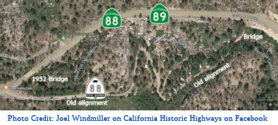 In February 2018, Joel Windmiller posted an interesting picture on Facebook.
It was of the Hope Valley, California Alpine County Hope Valley Resort,
Post Office, 76 gas station, Trailer Park and Camp ground along the West
Fork of the Carson River (approx 088 ALP 14.888). He noted that, from
1935-51, the original alignment of Route 88 traveled in front of the
building and thru the campground to end at the original bridge crossing
the river.
In February 2018, Joel Windmiller posted an interesting picture on Facebook.
It was of the Hope Valley, California Alpine County Hope Valley Resort,
Post Office, 76 gas station, Trailer Park and Camp ground along the West
Fork of the Carson River (approx 088 ALP 14.888). He noted that, from
1935-51, the original alignment of Route 88 traveled in front of the
building and thru the campground to end at the original bridge crossing
the river.
(Source: Joel Windmiller, FB Post, 2/15/2018)
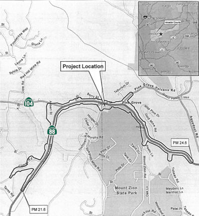
StatusPine Grove Improvements (10-Ama-88, PM 21.6/24.6) (PPNO 2454)
 The SAFETEA-LU act, enacted in August 2005 as the reauthorization of TEA-21, provided the
following expenditures on or near this route:
The SAFETEA-LU act, enacted in August 2005 as the reauthorization of TEA-21, provided the
following expenditures on or near this route:
There are plans for improvements to the route near Pine Grove. (~AMA 23.465) The public scoping has just begun; project approval is planed for 2012, with construction starting in 2024 and completing in 2028. The goal is to alleviate congestion, improve operations and enhance safety between the intersections at Climax Road and Mount Zion Road. Project components currently being studied include widening Route 88 through the Pine Grove and/or the construction of either a southerly or northerly two-lane bypass route.
In May 2016, the CTC approved for future consideration of funding a project in Amador County that will construct roadway improvements on a portion of Route 88 in the town of Pine Grove. The project is programmed in the 2014 State Transportation Improvement Program. The project is not fully funded. The total estimated cost is $41,000,000 for capital and support. Depending on the availability of funds, construction is estimated to begin in Fiscal Year 2020-21. The scope, as described for the preferred alternative, is consistent with the project scope programmed by the Commission in the 2014 State Transportation Improvement Program. A copy of the MND has been provided to Commission staff. The project will result in less than significant impacts to the environment after mitigation. The following resource area may be impacted by the project: biological resources. Avoidance and minimization measures will reduce any potential effects on the environment. These measures include, but are not limited to, pre-construction red-legged frog surveys will be conducted by a qualified biologist, staging areas will be located at least 100 feet from riparian or aquatic habitats, environmental awareness training will be given to all construction personnel, and all proposed landscape will incorporate native plant materials. As a result, an MND was completed for this project.
The 2018 STIP, approved at the CTC March 2018 meeting, appears to deallocate $3,075K in R/W funding for this project in FY19-20, and to allocate $2,751K for R/W funding in FY18-19.
The 2020 STIP, approved at the CTC March 2020
meeting,which made no changes to the funding programmed for PPNO 2454:
$2,751K in R/W funding approved in 10/2018.
(Source: March 2020 CTC Agenda, Item 4.7, 2020 STIP
Adopted 3/25/2020)
In June 2023, the CTC approved for future consideration
of funding the following project for which a Mitigated Negative
Declaration (MND) and an Addendum have been completed: Route 88 in Amador
County. Intersection and lane reconfiguration, pedestrian and bicycle
improvements, and roadway-related improvements on Route 88, in Amador
County. (PPNO 2454, 10-Ama-88, PM 21.6/24.6)
The project is located on Route 88 from postmile 21.6 to postmile 24.6, in
Amador County. The Department proposes intersection and lane
reconfiguration, pedestrian and bicycle improvements, and roadway-related
improvements on Route 88. The project is currently programmed in the 2022
State Transportation Improvement Program (STIP) for a total of
$14,429,000, which includes Right of Way (Capital) and Construction
(Capital). Construction began 2021-22. The scope, as described for the
preferred alternative, is consistent with the project scope as programmed
by the Commission in the 2022 STIP. A copy of the MND has been provided to
Commission staff. The Commission approved the project for future
consideration of funding on May 19, 2016, under Resolution E-16-24. The
revised scope includes two phases, the Revised Phase A, and the Ultimate
Phase. The Revised Phase A will construct most of the proposed
improvements, whereas the remaining improvements will be constructed in
the Ultimate Phase. Expanded Temporary Construction Easements (TCEs) were
included to the scope of Revised Phase A to facilitate construction. The
Department subsequently completed an Addendum to the MND pursuant to
California Environmental Quality Act (CEQA). The Department has approved
this project for construction. This approval and the Addendum will satisfy
the environmental requirements for this stage of the planning process.
(Source: June 2, 2023 Special CTC Meeting, Agenda Item 2.2c.(1))
In June 2023, the CTC approved the following STIP
allocation: $5,240,000. 10-Ama-88 22.7/23.6. PPNO 10-2454; ProjID
1000000047; EA 0G550. Pine Grove Improvements. On Route 88 from
post mile 22.7 east of Ridge Road to post mile 23.6 to Hilltop Road in the
town of Pine Grove in Amador County. Construct Phase A Project safety and
operational improvements. CEQA - MND, 02/16/2016; Re-validation
05/09/2023. NEPA - FONSI, 02/16/2016; Re-validation 05/09/2023. Right of
Way Certification: 02/02/2023. Future consideration of funding approved
under Resolution E-16-24; May 2016. Concurrent addendum for the previously
approved Future Consideration of Funding under Resolution E-23-99; June
2023. Programmed allocation: RIP/22-23 CONST $4,814,000; COVID-RIP/22-23
CONST $426,000.
(Source: June 2, 2023 CTC Agenda, Agenda Item 2.5c.(4))
The 2020 SHOPP, approved in May 2020, included the following new Roadway
Preservation item of interest: 10-Amador-88 R54.7/R60.8 PPNO 2680 Proj ID
1012000002 EA 0K130. Route 88 Near Kirkwood, from west of Foster Meadow
Road to 1.1 miles east of Shot Rock Vista Point. Rehabilitate pavement,
upgrade guardrail, replace signs, rehabilitate culverts, and construct
rumble strips.. Programmed in FY23-24, with construction scheduled to
start in May 2024. Total project cost is $25,044K, with $18,675K being
capital (const and right of way) and $6,369K being support (engineering,
environmental, etc.),
(Source: 2020 Approved SHOPP a/o May 2020)
Since it's construction, Route 88 has run across the top of the Silver Lake Dam (~ AMA R65.792). The increase in traffic began to create structural problems for the dam, so in 1998, Caltrans proposed creating a new crossing of the Silver Fork of the American River, just downstream from the dam. Construction started in March 2000, and was budgeted at $6.5 million, of which $2 million was for construction of a new bridge. This new bridge involved the use of the longest pre-cast girders ever placed on a California bridge—almost 40 meters long, weighing more than 70,000 kg.
Between Alpine Village (~ ALP 19.253) and Paynesville (~ ALP 22.724), an "Old State Highway 88" takes a less direct path, with a north terminus at the intersection of Foothill Road and Route 88 in Paynesville. (This is labeled as Old State Highway 88 by MSN's map service and Compass, but as "Carson River Road" by Mapquest.)
This route continues into Nevada as NV 88 to end at US 395. The designation of the NV 88 dates back to the 1976 Nevada route renumbering; previously, this was NV 37.
NamingThis segment from Route 49 to Route 89 (~ AMA 14.519 to ALP 19.074) is named the "Alpine State Highway". It was named by Resolution Chapter 468 in 1911.
 Historically, the portion of this route from Rout 49 near Jackson to Woodfords in Alpine county (~ AMA 14.519 to ALP 19.074) was called the "Kit Carson Pass Highway". It was named after the
Carson River and the Carson Pass, both named after Kit Carson. Christopher
Houston Carson (December 24, 1809 – May 23, 1868), better known as
Kit Carson, was an American frontiersman. He was a fur trapper, wilderness
guide, Indian agent, and U.S. Army officer. He became a frontier legend in
his own lifetime via biographies and news articles, and exaggerated
versions of his exploits were the subject of dime novels. Carson left home
in rural Missouri at age 16 to become a mountain man and trapper in the
West. In the 1830s, he accompanied Ewing Young on an expedition to Mexican
California and joined fur-trapping expeditions into the Rocky Mountains.
He lived among and married into the Arapaho and Cheyenne tribes. In the
1840s, Carson was hired as a guide by John C. Frémont. Frémont's
expeditions covered much of California, Oregon, and the Great Basin area.
Frémont mapped and wrote reports and commentaries on the Oregon Trail
to assist and encourage westward-bound pioneers, and Carson achieved
national fame through those accounts. Under Frémont's command, Carson
participated in the conquest of Mexican California at the beginning of the
Mexican–American War. Later in the war, Carson was a scout and
courier, celebrated for his rescue mission after the Battle of San Pasqual
and for his coast-to-coast journey from California to Washington, D.C. to
deliver news of the conflict in California to the government. In the
1850s, he was appointed as the Indian agent to the Ute Indians and the
Jicarilla Apaches.
Historically, the portion of this route from Rout 49 near Jackson to Woodfords in Alpine county (~ AMA 14.519 to ALP 19.074) was called the "Kit Carson Pass Highway". It was named after the
Carson River and the Carson Pass, both named after Kit Carson. Christopher
Houston Carson (December 24, 1809 – May 23, 1868), better known as
Kit Carson, was an American frontiersman. He was a fur trapper, wilderness
guide, Indian agent, and U.S. Army officer. He became a frontier legend in
his own lifetime via biographies and news articles, and exaggerated
versions of his exploits were the subject of dime novels. Carson left home
in rural Missouri at age 16 to become a mountain man and trapper in the
West. In the 1830s, he accompanied Ewing Young on an expedition to Mexican
California and joined fur-trapping expeditions into the Rocky Mountains.
He lived among and married into the Arapaho and Cheyenne tribes. In the
1840s, Carson was hired as a guide by John C. Frémont. Frémont's
expeditions covered much of California, Oregon, and the Great Basin area.
Frémont mapped and wrote reports and commentaries on the Oregon Trail
to assist and encourage westward-bound pioneers, and Carson achieved
national fame through those accounts. Under Frémont's command, Carson
participated in the conquest of Mexican California at the beginning of the
Mexican–American War. Later in the war, Carson was a scout and
courier, celebrated for his rescue mission after the Battle of San Pasqual
and for his coast-to-coast journey from California to Washington, D.C. to
deliver news of the conflict in California to the government. In the
1850s, he was appointed as the Indian agent to the Ute Indians and the
Jicarilla Apaches.
(Information source: Wikipedia; Image source: Bicycle Touring - Cross US '07 Report; Find a Grave)
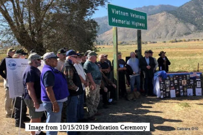 The portion of Route 88 from 5 miles southwest
of the Nevada State Line (ALP 20.000) to the Nevada state line (ALP 25.14)
in the County of Alpine is named the "Vietnam Veterans Memorial
Highway'. Many residents of the County of Alpine, including many
Washoe Tribal members and other community members, served in the United
States military during the Vietnam war with the support of friends,
family, and loves ones. The section was named to recognize the
contributions and sacrifices of these veterans, their friends, families,
and loved ones, helping to upgrade the Vietnam war from being classified
as the “Forgotten War”. Named by Assembly Concurrent
Resolution (ACR) 184, Res. Chapter 148, 8/17/2018. On October 15, 2019,
Alpine County officials joined with Washoe tribe members, California
Department of Transportation (Caltrans) officials, numerous state and
county elected officials and surviving family members of veterans from
Alpine County to officially unveil two memorial signs renaming the route
to the “Vietnam Veterans Memorial Highway”.
The portion of Route 88 from 5 miles southwest
of the Nevada State Line (ALP 20.000) to the Nevada state line (ALP 25.14)
in the County of Alpine is named the "Vietnam Veterans Memorial
Highway'. Many residents of the County of Alpine, including many
Washoe Tribal members and other community members, served in the United
States military during the Vietnam war with the support of friends,
family, and loves ones. The section was named to recognize the
contributions and sacrifices of these veterans, their friends, families,
and loved ones, helping to upgrade the Vietnam war from being classified
as the “Forgotten War”. Named by Assembly Concurrent
Resolution (ACR) 184, Res. Chapter 148, 8/17/2018. On October 15, 2019,
Alpine County officials joined with Washoe tribe members, California
Department of Transportation (Caltrans) officials, numerous state and
county elected officials and surviving family members of veterans from
Alpine County to officially unveil two memorial signs renaming the route
to the “Vietnam Veterans Memorial Highway”.
(Source for Dedication Ceremony Information: The Pine Tree, 10/15/2019)
 Named Structures
 The overlook just west of Peddler Hill on Route 88 is officially designated the "Bert Lund Memorial Overlook"
(AMA 52.6). Bert Lund was an employee of the Department of Highways. He
began as a chainman on a survey crew; he eventually worked his way up to
Senior District Engineer in charge of District 10, where he was involved
in the creation or upgrading of many of the roads in District 10,
including new bridges on Route 12 in the Delta, the making of Route 99
into a limited access freeway, the start of making Route 88 into a
year-round, all-weather highway, and the upgrading and maintenance of four
Sierra Nevada mountain passes (Carson, Ebbetts, Sonora, and Tioga). Named
by Assembly Concurrent Resolution No. 144, Chapter 106, in 1994.
The overlook just west of Peddler Hill on Route 88 is officially designated the "Bert Lund Memorial Overlook"
(AMA 52.6). Bert Lund was an employee of the Department of Highways. He
began as a chainman on a survey crew; he eventually worked his way up to
Senior District Engineer in charge of District 10, where he was involved
in the creation or upgrading of many of the roads in District 10,
including new bridges on Route 12 in the Delta, the making of Route 99
into a limited access freeway, the start of making Route 88 into a
year-round, all-weather highway, and the upgrading and maintenance of four
Sierra Nevada mountain passes (Carson, Ebbetts, Sonora, and Tioga). Named
by Assembly Concurrent Resolution No. 144, Chapter 106, in 1994.
(Image source: Youtube)
The "John G. Meyer Overlook", in Alpine County (E of Carson Pass) (ALP R5.4). It was named by Assembly Concurrent Resolution 86, Chapter 10, in 1990. John G. Meyer was long-time Caltrans employee, serving over 46 years, the last 15 of which were as a District Engineer in Caltrans District 10. He was instrumental in the completion and improvement of several important highways in Alpine County, including the development of Route 88 as an all-year highway. He was also well known for contributions to the Boy Scouts, the Salvation Army, the United Crusade, and was a member of the Engineers Club, the Rotary Club, the American Society of Engineers, and the Navy League.
 Scenic Route
[SHC 263.5] Entire portion.
 Other WWW Links
 National Trails
 Portions of this route approximate the National Pony Express Trail, specifically the segments between the junction with Route 89 W of
Sorensens to the Nevada State Line, although some segments veer of the
current route onto older routings.
Portions of this route approximate the National Pony Express Trail, specifically the segments between the junction with Route 89 W of
Sorensens to the Nevada State Line, although some segments veer of the
current route onto older routings.
 Freeway
[SHC 253.1] Entire route. Added to the Freeway and Expressway system in 1959.
 Interregional Route
[SHC 164.14] Entire route.
 Statistics
Overall statistics for Route 88:
 Pre-1964 Legislative Route
In 1933, two segments were added to the state highway system: "[LRN 15] near Sycamore to Woodland-Yuba City Road near Knights Landing", and "[LRN 45] near Glenn to [LRN 47] near Hamilton City". In 1935, these were codified into the code as LRN 88, which was defined as:
In 1959, Chapter 1062 changed the origin of the first segment to "[LRN 15] near Colusa".
This route is signed as follows:
© 1996-2020 Daniel P. Faigin.
Maintained by: Daniel P. Faigin
<webmaster@cahighways.org>.
 Route 87
 Route 89