
Former State Route 228
Click here for a key to the symbols used. An explanation of acronyms may be found at the bottom of the page.
 Routing
 Nocurrent
routing.
Nocurrent
routing.
 Post 1964 Signage History
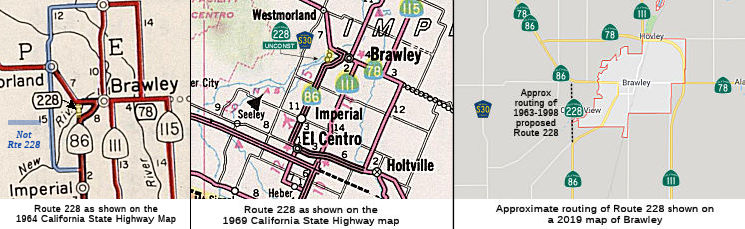
In 1963, Route 228 was defined as the route "Route 86 approximately
two and one-half miles southwest of Brawley to Route 86 approximately two
miles west of Brawley." The routing would roughly have been a continuation
of Imperial Avenue NB to near Kalin Ave, bypassing downtown Brawley. The
routing was never constructed or signed. There is no connection between
this routing and Brawley Bypass later constructed along Route 78
(bypassing downtown Brawley).
Tom Fearer provides some additional information. The routing would have
followed Malan Canal and Sandal Canal west of Brawley. The proposed route
was never mentioned in CHPW.
(Source: Gribblenation Blog (Tom Fearer), "Paper Highways: Unbuilt California State Route 228", July 2022)
In 1998, AB 2132, Chapter 877, (September 26, 1998) deleted the routing.
 Pre 1964 Signage History
This was LRN 26. It may have been a bypass of US 99.
 Statistics
Overall statistics for former Route 228:
- Total Length (1995): 2 miles unconstructed
- Mileage Classification: Rural: 2; Sm. Urban: 0; Urbanized: 0.
- Counties Traversed: Imperial.
 Other WWW Links
 Pre-1964 Legislative Route
In 1947 (1st Ex Sess), Chapter 11 defined LRN 228 as “a connection
between [LRN 5] and [LRN 69] near San Lorenzo”.
In 1959, Chapter 1062 swapped the endpoints and extended the routing to
[LRN 258]: “[LRN 69] [LRN 258] near San
Lorenzo to [LRN 5] near Hayward”
This is an unsigned portion of Route 238 between I-580 and unconstructed
Route 61.
Acronyms and Explanations:
- "LRN" refers to the Pre-1964 Legislative Route Number.
"US" refers to a US Shield signed route.
"I" refers to an Eisenhower Interstate signed route.
"Route" usually indicates a state shield signed route, but said route may be signed as US or I.
- Previous Federal Aid (pre-1992) categories:
Federal Aid Interstate (FAI); Federal Aid Primary (FAP);
Federal Aid Urban (FAU); and Federal Aid Secondary (FAS).
Current Functional Classifications (used for aid purposes):
Principal Arterial (PA); Minor Arterial (MA);
Collector (Col); Rural Minor Collector/Local Road (RMC/LR). Note that ISTEA repealed the previous Federal-Aid System, effective in 1992, and established the functional classification system for all public roads.
- Other frequently used terms: California Transportation Commission (Commission or CTC), California Department of Transportation (Department or Caltrans), Regional Improvement Program (RIP), Interregional Improvement Program (IIP), State Transportation Improvement Program (STIP), State Highway Operation and Protection Program (SHOPP), Traffic Congestion Relief Program (TCRP), Clean Air and Transportation Improvement Act of 1990 (Proposition 116), High Speed Passenger Train Bond Program (Proposition 1A), Highway Safety, Traffic Reduction, Air Quality, and Port Security Bond Act of 2006 (Proposition 1B), Corridor Mobility Improvement Account (CMIA), State Route 99 Bond Program (RTE or SR 99), Local Bridge Seismic Retrofit Account (LBSRA), Trade Corridors Improvement Fund (TCIF), Highway-Railroad Crossing Safety Account (HRCSA), State-Local Partnership Program (SLPP), Environmental Phase (PA&ED), Design Phase (PS&E), Right of Way (R/W), Fiscal Year (FY), Active Transportation Program (ATP), Trade Corridor Enhancement Program (TCEP), Local Partnership Program (LPP), Local Streets and Roads Program (LSRP), Solutions for Congested Corridors Program (SCCP).
 Route 227
 Route 229
© 1996-2020 Daniel P. Faigin.
Maintained by: Daniel P. Faigin
<webmaster@cahighways.org>.

 California Highways: