
 California Highways:
Click here for a key to the symbols used. An explanation of acronyms may be found at the bottom of the page.
 Routing
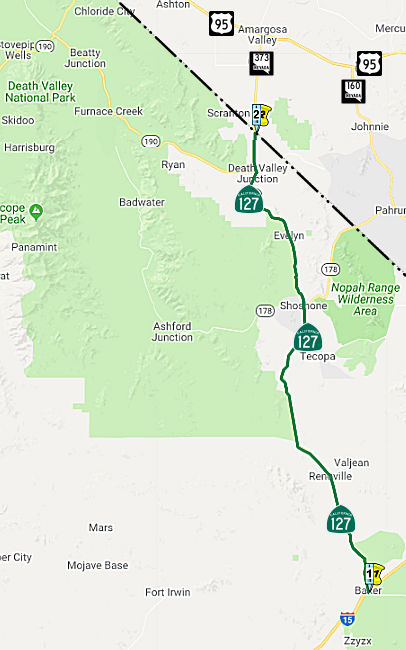 From Route 15 near Baker to the Nevada state line via the vicinity of Death Valley
Junction.
From Route 15 near Baker to the Nevada state line via the vicinity of Death Valley
Junction.
 Post 1964 Signage History
This routing is unchanged from its 1963 definition.
As of 2018, Route 127 was a two-lane undivided highway on generally level
terrain set in a rural, desert landscape. The lanes are 12 feet wide in
each direction with 1-foot wide shoulders. The opposing traffic along the
majority of this segment is separated by double-yellow lines. The
elevation ranges from approximately 587-feet to 594-feet above mean sea
level from south to north. There are no utilities, airports, housing, or
railroads in the vicinity of the project. The route is functionally
classified as a Rural Minor Arterial, connecting southeastern California
to Nevada and other rural highways. The route is part of the Interregional
Road System (IRRS) and is included as a Terminal Access Route within the
Surface Transportation Assistance Act (STAA) Network. Route 127 serves
local, interregional, recreational, and goods movement traffic while
providing access to Death Valley National Park and other recreational
lands.
(Source: Route 127 Rumble Strips Initial Study and [Proposed] MND, April 2018)
 Pre 1964 Signage History
In 1934, Route 127 was signed from Jct. US 91 at Baker to the California-Nevada State Line near Death Valley Junction. It was LRN 127 between Baker and Death Valley Junction (junction Route 190), and LRN 128 from Death Valley Junction to the Nevada state line. Both routes were defined in 1933. This is one of those rare routes (Route 58 is another) where the pre-1963 legislative number and the signed number are the same.
Caltrans characterized the history of the route as follows in a recent
EIR:
(Source: Route 127 Rumble Strips Initial Study and [Proposed] MND, April 2018)
Route 127 is a north-south highway that begins at I-15 near the community of Baker, continues north past the San Bernardino County line into Inyo County, and ends at the California-Nevada State border at Nevada 373. Route 127 is eligible for the State Scenic Highway System; however, it has not been designated by Caltrans as a scenic highway. In 1933, Route 127 was added to the State Highway System and went from I-15 in Baker to Death Valley Junction; Route 128 during this time continued from there to the Nevada state line. In the state highway renumbering of 1964, Route 127 was re-defined from I-15 to the Nevada state line and has remained unchanged since.
 Status
In December 2023, the CTC approved amending the following project into
the 2022 SHOPP: 08-SBd-127 0.89/41.47. PPNO 08-3023F; ProjID 0824000089;
EA 1P700. Route 127 Near Barstow, from 0.3 mile north of School Road to
the Inyo County line. Repair roadbed and pavement, armor eroded
embankments, backfill shoulders, remove debris, repair drainage, and
provide traffic control. Note: Winter storms between September 1,
2023 and September 2, 2023, brought heavy rains that caused widespread
flooding, debris flows, pavement undermining, roadbed washouts, and
culvert distress and caused a full road closure to the traveling public.
This project will repair roadbed and pavement, armor eroded embankments,
backfill shoulders, remove debris, repair drainage, and provide traffic
control. Allocation ($ × $1000) PA&ED $100; PS&E $200; R/W
Sup $50; Con Sup $2,150; R/W Cap $1,000; Const Cap $9,000; TOTAL $12,500.
FY23-24.
(Source: December 2023 CTC Agenda, Agenda Item 2.1a.(1a) #21)
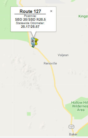
Widening and Rumble Strips Project | 08-SBd-127 28.0/R28.5
 In January 2018, it was reported that Caltrans was
planning to widen the shoulders of Route 127 in Fall 2018 and to install
rumble strips between PM SBD 28.0 and SBD 28.5. Caltrans plans to
construct 8-foot-wide shoulders and install 12-inch-wide rumble strips
along each direction and the centerline of the highway in an
unincorporated area of San Bernardino County. Light grading will also be
performed to accommodate shoulder widening. The safety project is
scheduled to be completed in early 2019.
In January 2018, it was reported that Caltrans was
planning to widen the shoulders of Route 127 in Fall 2018 and to install
rumble strips between PM SBD 28.0 and SBD 28.5. Caltrans plans to
construct 8-foot-wide shoulders and install 12-inch-wide rumble strips
along each direction and the centerline of the highway in an
unincorporated area of San Bernardino County. Light grading will also be
performed to accommodate shoulder widening. The safety project is
scheduled to be completed in early 2019.
In April 2018, Caltrans posted the Initial Study /
with [Proposed] Mitigated Negative Declaration for the Route 127
Shoulder Widening and Rumble Strips Project, 08-SBD-127 (PM 28.0/28.5).
Caltrans proposes to construct, in both directions, eight-foot shoulders
and install in-ground rumble strips (12 inches wide), along the centerline
and shoulders on Route 127 from Post Mile (PM) 28.0 to PM 28.5, located 28
miles north of the nearest community of Baker in San Bernardino County.
These improvements would occur from the beginning of curve to the end of
curve, and transitions. The granting of a 40-foot easement from the
centerline (in both directions) of undeveloped U.S. Bureau of Land
Management (BLM) land is anticipated.
(Source: Route 127 Rumble Strips Initial Study and [Proposed] MND, April 2018)
In August 2018, the CTC approved $1,339,000 in SHOPP
funding for San Bernardino 08-SBd-127 28.0/R28.5 Route 127 Near Baker,
28.0 miles north of Route 15 to 1.2 miles south of Saratoga Springs Road.
Outcome/Output: Construct shoulders and install ground-in rumble strips.
This will reduce the number and severity of collisions.
(Source: August 2018 CTC Agenda Item 2.5f.(3) Item
12)
In August 2018, the CTC approved for future
consideration of funding the following project for which a Mitigated
Negative Declaration (MND) has been completed: Route 127 in San Bernardino
County (08-SBd-127, PM 28.0/28.5). Construct roadway improvements on a
portion of Route 127 near the town of Baker. (PPNO 0216F) This project is
located near Baker, south of Saratoga Springs Road in San Bernardino
County The project proposes to widen and construct paved shoulders and
ground-in rumble strips on Route 127. The project proposes to reduce the
number and severity of cross centerline and runoff road type collisions.
The proposed project is currently estimated to cost approximately $2.5
million in capital and right of way. The project is fully funded and is
currently programmed in the 2016 SHOPP for approximately $2.5 million
which includes Construction (capital and support) and Right-of-Way
(capital and support). The project is estimated to begin construction in
2019. The scope, as described for the preferred alternative, is consistent
with the project scope programmed by the Commission in the 2016 SHOPP.
(Source: August 2018 CTC Agenda Item 2.2c(1))
 Freeway
[SHC 253.6] From Route 15 near Baker to Route 190 near Death Valley Junction (not upgraded). Added to the Freeway and Expressway system in 1959.
 Scenic Route
[SHC 263.1] Entire route.
 Interregional Route
[SHC 164.16] Entire route.
 Other WWW Links
 Statistics
Overall statistics for Route 127:
 Pre-1964 Legislative Route
In 1933, Chapter 767 added the following routes to the state highway system: "
In 1935, LRN 127 was added to the highway code with the following definition, which covered most of these routes:
The "connection to the California-Nevada State Line" was added as part of LRN 128.
In 1959, Chapter 1355 rerouted segment (a) combining it with (c), and clarified (b), giving:
This was signed as follows:
This segment was signed, along the constructed portions, as Route 190 to Death Valley Junction, and as Route 127 from Death Valley Junction to I-15. (and dates back to the initial 1934 signage of state routes).
This segment appears to have been unsigned; it is present-day Route 136.
Note: The Gribblenation Blog on Route 136 (Tom Fearer) has a bit more information on the routings of LRN 127 and the timing of acquisitions. The following is a quote from the blog, in case the page disappears (module some terminology adjustments):
The routing of Route 136 was part of Legislative Route Number (LRN) 127. LRN 127 was adopted in 1933 and generally was signed as Route 190 through all segments of the highway. The original routing of LRN 127 can be seen on the California Division Highways Map of Inyo County. Interestingly LRN 127 is shown running on Horseshow Meadow Road to Lonepine and has a gap from the yet obtained Eichbaum Toll Road in Panamint Valley.
By 1938 the state had obtained the right-of-way for the Eichbaum Toll Road. Route 190 is shown running from US 99 east to Quaking Aspen in the Sierras. A proposed route through the Sierras via Kern Canyon to Horseshoe Meadow is shown. Route 190 is shown on the current routing of Route 136.
By 1960 a new proposed alignment of Route 190 from Quaking Aspen to Olancha was adopted. This new alignment included the modern segment of Route 190 east of US 395 to Route 136.
By 1964 the California Highway Renumbering had occurred and a new number of 136 was assigned to the highway between Lone Pine to the modern Route 190 junction at Owens Lake.
© 1996-2020 Daniel P. Faigin.
Maintained by: Daniel P. Faigin
<webmaster@cahighways.org>.
 Route 126
 Route 128