
 California Highways:
Click here for a key to the symbols used. An explanation of acronyms may be found at the bottom of the page.
 Routing
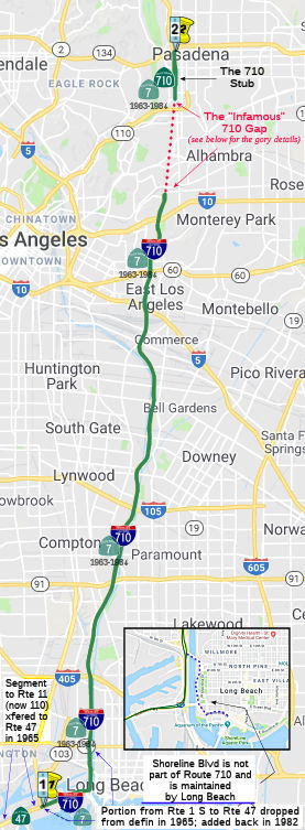
 From Route 1 to Route 210 in Pasadena.
The route also includes that portion of the freeway between Route 1 and the northern end of Harbor Scenic Drive, that portion of Harbor Scenic Drive to Ocean Boulevard, that portion of Ocean Boulevard west of its intersection with Harbor Scenic Drive to its junction with Seaside Boulevard, and that portion of Seaside Boulevard from the junction with Ocean Boulevard to Route 47.
Section 622.3 of the Streets and Highway Code explicitly authorizes relinquishment of the Pasadena stub, per SB 7 (Chapter 835, 10/21/2019):
(a) Upon a determination by the commission that it is in the best interest of the state to do so, the commission may, upon terms and conditions approved by it, relinquish to the City of Pasadena the portion of Route 710 within the jurisdictional limits of that city, if the department and the city enter into an agreement providing for that relinquishment.
(b) A relinquishment under this section shall become effective on the date following the county recorder’s recordation of the relinquishment resolution containing the commission’s approval of the terms and conditions of the relinquishment.
(c) On and after the effective date of the relinquishment, all of the following shall occur:
(1) The relinquished portion of Route 710 shall cease to be a state highway.
(2) The relinquished portion of Route 710 shall be ineligible for future adoption under Section 81.
(3) The City of Pasadena shall ensure the continuity of traffic flow on the relinquished portion of Route 710.
Note: SB 7 modified the definition of the route in the Freeway and Expressway system (Article 2 of the SHC) to, as of 1/1/2024, delete the gap between Alhambra Ave in Los Angeles and California Street in Pasadena (i.e., the space between the stubs) from the freeway and expressway system. This means that if the state wants a freeway in that segment, they have to start the route adoption process from scratch. SB 7 does not authorize relinquishment of the Alhambra stub, nor any portion of the unconstructed gap that is not in the City of Pasadena.
In June 2022, the CTC authorized relinquishment of right of way in the
city of Pasadena along State Route 710 between Columbia Street and Union
Street (15 segments, 07-LA-710-PM T30.9/R32.5), under terms and conditions
as stated in the relinquishment agreement dated June 1, 2022, determined
to be in the best interest of the State. Authorized by Chapter 835,
Statutes of 2019, which amended Section 622.3 of the Streets and Highways
Code. Note: The relinquishment resolution does not appear to include
the portion between where Route 210 transitions off and Union Street, so
it is unclear if that now smaller stub will remain part of Route 710, or
will be classified as alternative mileage of Route 210. Further, the
relinquishment does not include the Route 134 transition ramps or the
Route 210 transition ramps, which are not part of Route 710.
(Source: June 2022 CTC Agenda, Agenda Item
2.3c.(2), including yellow and pink supplementary material)
 Post 1964 Signage History
Until July 1, 1964, this routing was signed as Route 15. When the Route 15 signage had to be applied to the new Interstate (I-15) that had previously been US 91 (between I-10 and Las Vegas), the routing was renumbered as Route 7:
In 1963, Route 7 was defined as "from Route 11 [Present-Day Route 110] in San Pedro to Route 210 in Pasadena via Long Beach and including a bridge, with at least four lanes, from San Pedro at or near Boschke Slough to Terminal Island." In 1965 the southern end was truncated by Chapter 1372, transferring the San Pedro portion and bridge to Route 47, and dropping the portion S of Route 1 to Route 47 from the definition of the route. This left the route definition as "from Route 1 to Route 210 in Pasadena." (which harkened back, origin-wise, to the original 1933 definition of LRN 167).
On October 19, 1965, construction broke ground on the Gerald Desmond
Bridge along Seaside Boulevard in Long Beach. The structure was a
direct replacement for the 1944 Terminal Island Pontoon Bridge. The
intent of the Gerald Desmond Bridge was to provide a direct link for
Terminal Island traffic to reach the Long Beach Freeway. The Gerald
Desmond Bridge was completed during June 1968. The Gerald Desmond
Bridge was a five lane through arch span which was 5,134 feet long.
(Source: Gribblenation Blog (Tom Fearer), "Interstate 710", 8/26/2023)
In 1982, Chapter 914 extended the definition to explicitly add back in the portion of the freeway between Route 1 and the northern end of Harbor Scenic Drive, that portion of Harbor Scenic Drive to Ocean Boulevard, that portion of Ocean Boulevard west of its intersection with Harbor Scenic Drive to its junction with Seaside Boulevard, and that portion of Seaside Boulevard from the junction with Ocean Boulevard to Route 47. It was noted that this extension didn't become operative unless the commission approves a financial plan that included a cost estimate and the source of funding to make the route for the portion S of Route 1 and any proposed improvements. Note: The northern end of Harbor Scenic Drive is where 7th Street veers to the E across the Shoemaker Bridge; this means that the Shoemaker Bridge and the "freeway" portion running down to the Long Beach Pier was NOT part of the State Highway System.
In 1984, Chapter 409 defined Route 710 as "Route 1 to Route 210 in Pasadena." The additional conditions regarding the Harbor Scenic Drive and the financial conditions were also transferred. This reflected the approval of Route 7 as 139(a) non-chargable interstate for continuity of numbering with Route 10 (I-10), off of which it spurs. [One might argue that it could have been considered a loop route around the center of the city, and as such, would more appropriately have an (even digit)05 number. However, all of the (even-digit)05 numbers are in use: I-205 (Sacramento), I-405 (Los Angeles), I-605 (Los Angeles), I-805 (San Diego).]
The legislative description of Route 710 transferred from Route 7 still included the portion between Route 1 and the northern end of Harbor Scenic Drive, a portion of Harbor Scenic Drive to Ocean Blvd, a portion of Ocean Blvd west of its intersection with Harbor Scenic Drive to its junction with Seaside Blvd, and a portion of Seaside Blvd from the junction with Ocean Blvd to Route 47. For a long time, this was ambiguously signed; it was signed as part of the route after planned port-related improvements by the cities of Long Beach and Los Angeles were completed. The segment from Ocean Blvd to Route 1 is non-chargeable 139(b) mileage. There are some indications that this segment was signed with a state, not Interstate, shield, at least until it was upgraded to full freeway as part of updates in the 2010s..
To make it clear: The south end of I-710 follows the west riverbank, not the east riverbank (into downtown Long Beach, across the Shoemaker Bridge). Caltrans only maintains the east riverbank spur until the 9th Street exit; the City of Long Beach has control of the road (Shoreline Drive) past this point (however, ownership of the Shoemaker Bridge will be changing post 2020). Route 710 is supposed to follow the Long Beach Freeway down to the Harbor Scenic Drive cutoff south of Anaheim Street (now constructed freeway), and then follow Harbor Scenic Drive (again, now constructed freeway) to Ocean Blvd (Seaside Freeway) and then follow Ocean Blvd across the Gerald Desmond Bridge to the junction of Ocean and Seaside Blvds with the Terminal Island Freeway. According to Caltrans, once the replacement for the Gerald Desmond bridge is completed, Ocean Boulevard will be the westward extension of Route 710 to the Terminal Island Freeway (Route 47). Ocean Boulevard is currently operated by the City of Long Beach. After the bridge is completed, it and the segment of Ocean Boulevard between Route 47 and Route 710 will be adopted into the State Highway System and the roadway transferred to Caltrans. The extension across the Shoemaker Bridge (7th Street) towards the Queen Mary, Cruise Terminals, Aquarium and the parks is Shoreline Blvd (although the Queen Mary is also accessible via S Harbor Scenic Drive).
[In fact, the state did not construct the portion of I-710 S of Route 1, across the Shoemaker Bridge That portion was constructed to freeway standards by the City of Long Beach. The construction cost was $12 million.]
On September 23, 1983, Caltrans submitted an application to add Route 7
and the Long Beach Freeway from Route 1 in Long Beach to I-10 to the
Interstate System as I-710. The American Association of State
Highway Transportation Officials (AASHTO) approved the addition of I-710
on May 24, 1984. During October 1984, the FHWA would approve the
addition of I-710 and the Long Beach Freeway from Route 1 to I-10 as
non-chargeable Interstate. On December 8, 1984, AASHTO would approve a
second request by Caltrans to extend I-710 to Ocean Boulevard at the Port
of Long Beach. Note: The portion S of Ocen Blvd, and the
portion N of I-10, are not part of the I-710 designation.
(Source: Gribblenation Blog (Tom Fearer), "Interstate 710", 8/26/2023)
 The route is unconstructed and unsigned between Columbia St and I-210 in Pasadena, although there is a stub of Route 710 (not Interstate)
at the Route 134/I-210 junction. There has been intense local opposition
to completion of this freeway as it would have a potentially adverse
impact on historic homes in Pasadena and South Pasadena. On the other
hand, it is a critical link in the overall Southern California freeway
system. The traversable route is... oh hell, just read the mishegas below
in the STATUS section.
The route is unconstructed and unsigned between Columbia St and I-210 in Pasadena, although there is a stub of Route 710 (not Interstate)
at the Route 134/I-210 junction. There has been intense local opposition
to completion of this freeway as it would have a potentially adverse
impact on historic homes in Pasadena and South Pasadena. On the other
hand, it is a critical link in the overall Southern California freeway
system. The traversable route is... oh hell, just read the mishegas below
in the STATUS section.
In 2013, Chapter 525 (SB 788, 10/9/13) deleted the words in the route definition about a financial plan:
(b) Subdivision (a) shall not become operative, and this section shall be repealed on January 1, 1985, unless the commission approves, not later than December 31, 1984, a financial plan, which is submitted to them by the Los Angeles County Transportation Commission not later than January 1, 1984.
(c) The financial plan shall be prepared in cooperation with the department and shall include, but not be limited to, a cost estimate and the source of funding to make the route changes in subdivision (a) and any proposed improvements.
In 2019, both AB 29 (Chapter 791, 10/21/2019) and SB 7 (Chapter 835, 10/21/2019) were chaptered, and SB 7, being chaptered last, took precedence. SB 7 changed the definition of the route in the freeway and expressway system to prepare for relinquishment of the Route 710 gap (note that it did not change the definition of the route itself):
(2) Route 1 near the City of Long Beach to Route 10 near the City of Alhambra.
(3) Route 10 near the City of Alhambra to Route 210 near the City of Pasadena.
SB 7 explicitly requires, that as of 1/1/2024, items (2) and (3) are changed to
(2) Route 1 near the City of Long Beach to
Route 10 near the City of AlhambraAlhambra Avenue in the City of Los Angeles.(3)
Route 10 near the City of AlhambraCalifornia Boulevard in the City of Pasadena to Route 210.
This explicitly deletes the unconstructed portion of Route 710 from the freeway and expressway system. Further, SB 7 added Section 622.3 to the SHC to read:
(a) Upon a determination by the commission that it is in the best interest of the state to do so, the commission may, upon terms and conditions approved by it, relinquish to the City of Pasadena the portion of Route 710 within the jurisdictional limits of that city, if the department and the city enter into an agreement providing for that relinquishment.
(b) A relinquishment under this section shall become effective on the date following the county recorder’s recordation of the relinquishment resolution containing the commission’s approval of the terms and conditions of the relinquishment.
(c) On and after the effective date of the relinquishment, all of the following shall occur:
(1) The relinquished portion of Route 710 shall cease to be a state highway.
(2) The relinquished portion of Route 710 shall be ineligible for future adoption under Section 81.
(3) The City of Pasadena shall ensure the continuity of traffic flow on the relinquished portion of Route 710.
In May 2022, it was reported that the Pasadena City Council voted to
approve their end of a contract with Caltrans to reclaim a portion of the
land that Caltrans had already purchased for extending Route 710
– land located between Union Street and Columbia Street. The
California Transportation Commission needs to approve the transfer, but
with Caltrans and the city in agreement, that last hurdle could well be
little more than a formality. Without this land, the 710 gap closure
project will be so dead that it can’t be resurrected. On Wednesday,
June 29, the California Transportation Commission voted to officially
enable Pasadena to redesign the “710 Stub,” a corridor between
the 710 and the 210. The approval of this deal does not include the
parcels of land north of California Blvd that include residential and
institutional tenants. According to the Roberti Bill, existing tenants
will have first right of refusal, but none of this legislation addresses
how these properties will be sold. It seems that the City is waiting to
ascertain which tenants will purchase their properties before establishing
a plan for selling the properties and for the undeveloped stub of land,
known colloquially as The Ditch.
(Source: 669xGxaLjwqejoaIaV13l5bsLPKY9BVt4CtqdV6KUPa6lUIBf-O3IU">Streetsblog LA, 5/4/2022; Colorado
Boulevard . Net, 5/7/2022)
In June 2022, the CTC authorized relinquishment of right of way in the
city of Pasadena along State Route 710 between Columbia Street and Union
Street (15 segments, 07-LA-710-PM T30.9/R32.5), under terms and conditions
as stated in the relinquishment agreement dated June 1, 2022, determined
to be in the best interest of the State. Authorized by Chapter 835,
Statutes of 2019, which amended Section 622.3 of the Streets and Highways
Code.
(Source: June 2022 CTC Agenda, Agenda Item
2.3c.(2), including yellow and pink supplementary material)
The following freeway-to-freeway connections were never constructed:
 Pre 1964 Signage History
This was formerly signed as Route 15, and was LRN 167, defined in 1933. Until the construction of the freeway, Route 15 ran between Pacific Coast Highway and US 99 along Atlantic Blvd. In 1964, the freeway routing was renumbered as Route 7, and was later renumbered as Route 710 and I-710.
The history of what became I-710 in the Port of Los Angeles is a bit convoluted, and centers around LRN 167, LRN 231, and the future Route 47 and Route 103 as well.
In 1933, the route from "Long Beach via Atlantic Boulevard to [LRN 26] near Monterey Park" was added to the state highway system. In 1935, it was added to the highway code as LRN 167, with the same routing. Note the starting point of the route was not the Port of Los Angeles -- it is Pacific Coast Highway (US 101A, US 6) in the city of Long Beach.
The alignment of Sign Route 15/LRN 167 as of 1935 began at US 101A/LRN 60
(formerly Sign Route 3) in Long Beach, and followed Atlantic Avenue north
to Olive Street near Clearwater, Hynes and Compton. Sign Route 15/LRN 167 crossed the Los Angeles River via Olive Avenue and rejoined
Atlantic Avenue. North of Compton the route followed Atlantic Avenue to US 99-US 60-US 70/LRN 26 in Monterey Park. In 1938, Sign Route 15/LRN 167 was
realigned onto the new Los Angeles River Bridge between Artesia Avenue and
Compton Boulevard, making the two segments of Atlantic Avenue continuous.
(Source: Gribblenation Blog (Tom Fearer), "Interstate 710", 8/26/2023)
During 1944 the eastern half of Terminal Island was connected to Long
Beach via pontoon bridge. The Pontoon structure span was intended to
be a temporary aid to facilitate movement to the Terminal Island Naval
Facilities. The Terminal Island Pontoon Bridge connected Seaside
Boulevard to Harbor Scenic Drive in Long Beach.
(Source: Gribblenation Blog (Tom Fearer), "Interstate 710", 8/26/2023)
In 1947 (1st ex. sess.), Chapter 11 adjusted LRN 167. It kept the same endpoints, but introduced a discontinuity at (former) Route 245/US 101: "(a) Long Beach to [LRN 166]; (b) (a) above, near Los Angeles River to [LRN 26] via Atlantic Boulevard"
In 1949, Chapter 1467 combined the segments of LRN 167 and extended the route to [LRN 205] (Pasadena Freeway): "Long Beach to [LRN 205] in South Pasadena"
 In 1949, Chapter 1261 defined LRN 231. This was a
proposed freeway connection between then Route 11 and the Los Angeles
River Freeway (then Route 15, now I-710) that would be an extension of the
Federally-built Terminal Island Freeway (which wasn't yet in the state
highway system). It was contingent on Federal funding for the portion on
the mainland, and state funding for the non-mainland (Terminal Island)
portion, which never materialized. See Route 103 for the details. The key
points in the definition were that it was “via the mainland portion
of Long Beach Outer Harbor and Terminal Island,” and “If funds
from sources other than state highway funds have not been made available
for the construction on all portions of said [LRN 231] that are not on the
mainland prior to January 15, 1953, said [LRN 231] shall on that date
cease to be a state highway and this section shall have no further force
or effect.”
In 1949, Chapter 1261 defined LRN 231. This was a
proposed freeway connection between then Route 11 and the Los Angeles
River Freeway (then Route 15, now I-710) that would be an extension of the
Federally-built Terminal Island Freeway (which wasn't yet in the state
highway system). It was contingent on Federal funding for the portion on
the mainland, and state funding for the non-mainland (Terminal Island)
portion, which never materialized. See Route 103 for the details. The key
points in the definition were that it was “via the mainland portion
of Long Beach Outer Harbor and Terminal Island,” and “If funds
from sources other than state highway funds have not been made available
for the construction on all portions of said [LRN 231] that are not on the
mainland prior to January 15, 1953, said [LRN 231] shall on that date
cease to be a state highway and this section shall have no further force
or effect.”
In 1951, Chapter 1562 truncated the terminus of LRN 167 to Huntington Drive: "… to Huntington Drive."
In 1951, it was announced that the planned Los Angeles River Freeway of
Sign Route 15/LRN 167 had been renamed the "Long Beach Freeway."
That name had been adopted by a Los Angeles County Board of Supervisors
resolution. The concept of the Long Beach Freeway started 14 years
prior by the Long Beach City Engineering Department. The Long Beach
Freeway had a planned southern terminus near Anaheim Street in Long Beach
which would connect to the vicinity of the Terminal Island Pontoon Bridge.
(Source: Gribblenation Blog (Tom Fearer), "Interstate 710", 8/26/2023)
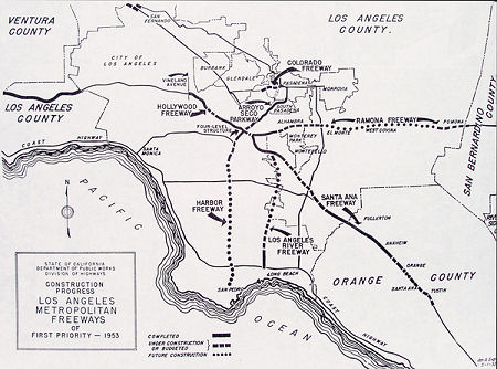
Construction started on the Long Beach Freeway around 1952, with the
first construction unit between US 101A/LRN 60 to 23rd Street. The
planned opening was July 1954. The city of Long Beach retained
right-of-way to construct an extension of the Long Beach Freeway south of
US 101A towards Terminal Island. The route of the Long Beach Freeway from
the Santa Ana Freeway to Huntington Drive was adopted by the California
Highway Commission on July 24, 1953.
(Source: Gribblenation Blog (Tom Fearer), "Interstate 710", 8/26/2023)
By 1954, LRN 231 had disappeared, eliminating the connection between LRN 167 and LRN 165.
Sign Route 15/LRN 167 was relocated onto the completed Long Beach Freeway
from US 101A/LRN 60 north to Atlantic Avenue near Compton by 1955.
(Source: Gribblenation Blog (Tom Fearer), "Interstate 710", 8/26/2023)
In 1957, Chapter 1911 extended the origin of LRN 167 to [LRN 165] (Harbor
Freeway): “[LRN 165] in San Pedro Long Beach
to Huntington Drive via Long Beach”. This provided a
different routing to connect the two highways distinct from the Terminal
Island Freeway (former LRN 231) routing. But as one can see from the map,
the routing wasn't quite the current routing yet.
Also in 1957, approximately 10 of the 16.5 miles of the state-owned
portion (LRN 167) of the Long Beach Freeway from US 101A/LRN 60 to the
Santa Ana Freeway (US 101/LRN 166) was completed. The extension
north to Huntington Drive was originally known as the Concord Freeway when added to the State Highway System during 1951. The Concord Freeway was reassigned to
the Long Beach Freeway corridor by the California Highway Commission
during November 1954.
(Source: Gribblenation Blog (Tom Fearer), "Interstate 710", 8/26/2023)
In 1958, Chapter 74 added the San Pedro-Terminal Island Bridge to LRN 167: "[LRN 165] in San Pedro to Huntington Drive via Long Beach, and including a bridge with at least four lanes from San Pedro at or near Boschke Slough to Terminal Island".
The proposed Terminal Island Bridge appears as a concept drawing in the
May/June 1959 California Highways & Public Works. The article
notes the California Highway Commision on April 30, 1959, decided to fund
the Terminal Island Bridge as a tolled facility. The Terminal Island
Bridge project area was approximately 7,400 feet, and would be constructed
a short distance north of the Terminal Island Ferry route in San
Pedro. The Terminal Island Bridge was planned to tie into Seaside
Avenue on Terminal Island near Mormon Street, and was planned as a
component of the Long Beach Freeway.
(Source: Gribblenation Blog (Tom Fearer), "Interstate 710", 8/26/2023)
In 1959, Chapter 1062 extended LRN 167 to LRN 9: "[LRN 165] in San Pedro
to Huntington Drive [LRN 9] in Pasadena via Long
Beach, and including a bridge with at least four lanes from San Pedro at
or near Boschke Slough to Terminal Island"
By 1960, the routing in the port had assumed the current approach running to Route 47 (portions of which were LRN 167 across the Vincent Thomas Bridge, added in 1963).
In 1960, it was noted that the Terminal Island Bridge was adopted as part
of a 1.6-mile freeway by the California Highway Commission on August 28,
1959. It was also noted construction by the city of Long Beach on
their portion of the Long Beach Freeway had reached Broadway by 1959, but
that the Long Beach Freeway designation as officially defined ended at US 101A. The bridge was eventually renamed the Vincent Thomas Bridge (see
Route 47), and made part of the Seaside Freeway. Despite the Vincent
Thomas Bridge no longer being part of the Long Beach Freeway corridor, it
was still part of LRN 167 and Sign Route 15.
(Source: Gribblenation Blog (Tom Fearer), "Interstate 710", 8/26/2023)
In the 1964 renumbering, Sign Route 15 became Route 7, defined as "From Route 11 in San Pedro to Route 210 via Long Beach and including a bridge, with at least four lanes, from San Pedro at or near Boshlke Slough to Terminal Island." In 1965, the Vincent Thomas Bridge was moved to Route 47, and Route 7 was adjusted to start at Route 1.
Note that the actual construction of the freeway routing for future Route 710 between Pacific Coast Highway and Route 47 did not occur for many years, and was primarily a result of a land-swap with the City of Long Beach where a portion of Seaside Blvd was given to the state in exchange for the portion of Route 103 N of Pacific Coast Highway.
According to KCET, Route 710 can be traced back to the "Great Free-Harbor
Fight" of the 1890s, where Los Angeles City officials helped solidify the
port in San Pedro by annexing a sixteen-mile "shoestring district" that
made the harbor a legal part of the city. Los Angeles also spent $10
million on harbor improvements, and proposed the construction of a truck
highway for developing the port. Although millions of dollars were poured
into the port's infrastructure by the early 1940s, not much was done to
facilitate any port highway. Before state planners (responsible for
designing state freeways) could map out a freeway from the ports to the
Los Angeles metropolis, harbor interest had already begun making
preliminary maps as early as 1921; though nothing materialized. Despite a
1939 California Freeway Law that gave "the state broad powers of land
acquisition for the construction [and financing] of freeways," it was the
City of Long Beach that took it upon themselves to plan, construct, and
finance the port highway, to be called the Los Angeles River Freeway
because it hugged the natural waterways that were once the lifeblood of
the founding families. So, Route 710 is essentially the child of the City
of Long Beach, superseding legal precedents that had placed the state of
California, not local governments, as the principal investors and
designers of state freeways (note that Route 710 was originally just a
state route: initially Route 15, and then later renumbered as Route 7 in
1964. It was eventually renumbered as non-chargable I-710).
(Source: KCET — History of the 710 Freeway, 2/12/2014)
An August 1941 report issued by the Regional Planning Commission of Los
Angeles County entitled “A Report on the Feasibility of a Freeway
Along the Channel of the Los Angeles River” proposed a
four-lane roadway on each levee from Anaheim Street in Long Beach north to
Sepulveda Boulevard in the San Fernando Valley; excepting between Soto
Street and Dayton Street in downtown Los Angeles, where, due to a lack of
right-of-way along the river, the alignment matches the future alignment
of the US 101 portion of the Santa Ana Freeway. There is no mention in the
report of a master plan of freeways like that issued in 1947, although the
maps showed connections to the already-completed Arroyo Seco Parkway and
the proposed Ramona and Rio Hondo Parkways.
(Source: Daniel Thomas)
In the 1930s and 1940s, before the route was adopted as a freeway routing, the cities of Long Beach and Los Angeles knew the route was coming, and began preserving right of way along the Los Angeles River for the future route. This saved significant money for right of way acquisition.
 By 1949, Long Beach had already invested
$1,000,000 on the freeway, and the city's Chamber of Commerce made
reoccurring appeals to the California State Highway Commission for
continued support. This unorthodox practice of an independent agency
developing their own freeway was not unnoticed by the California Division
of Highways, the precursor to Caltrans. "The southerly extension of the
Los Angeles River Freeway," as noted in their bi-monthly publication
California Highway and Public Works, "requires special mention because the
construction work now in progress by the City of Long Beach is the only
instance since World War II of another governmental agency carrying out
the construction and financing of a complete unit on the Los Angeles
Metropolitan Freeway System." Several years before the Los Angeles River
Freeway was legislated into the California State Highway System in 1947,
Long Beach planners received general counsel from the Los Angeles County
Regional Planning Commission, but were largely free from state
interference when designing the freeway. Long Beach Harbor authorities
even financed a "major portion" of the freeway, in what the state
acknowledged was a "staggering" amount, a figure that reached
approximately $12 million by 1953, according to a the Division of
Highways. Essentially, the freeway was constructed to serve business
generated by the harbor and local industry; commuter vehicular traffic was
secondary, at best. Any negative impact to communities during or after the
construction of the freeway was seen as all but non-existent. Segments of
Route 710 eventually connected with I-5, in the heart of the manufacturing
district in East Los Angeles, by the 1960s. This district housed extensive
intermodal railyards from the Union Pacific, and the Atchison, Topeka and
Santa Fe Railroad. As such, some of the early freeway construction of
Route 710 required multiple bridges over eighteen railroad tracks,
requiring 1,100 parcels of real estate. Route 710 cut through established
communities, such as East Los Angeles and City of Commerce, that already
housed dozen of freeway lane miles. In East Los Angeles, nearly 11,000
residents were displaced due to freeway construction and widenings,
consuming some 7% of total land area.
By 1949, Long Beach had already invested
$1,000,000 on the freeway, and the city's Chamber of Commerce made
reoccurring appeals to the California State Highway Commission for
continued support. This unorthodox practice of an independent agency
developing their own freeway was not unnoticed by the California Division
of Highways, the precursor to Caltrans. "The southerly extension of the
Los Angeles River Freeway," as noted in their bi-monthly publication
California Highway and Public Works, "requires special mention because the
construction work now in progress by the City of Long Beach is the only
instance since World War II of another governmental agency carrying out
the construction and financing of a complete unit on the Los Angeles
Metropolitan Freeway System." Several years before the Los Angeles River
Freeway was legislated into the California State Highway System in 1947,
Long Beach planners received general counsel from the Los Angeles County
Regional Planning Commission, but were largely free from state
interference when designing the freeway. Long Beach Harbor authorities
even financed a "major portion" of the freeway, in what the state
acknowledged was a "staggering" amount, a figure that reached
approximately $12 million by 1953, according to a the Division of
Highways. Essentially, the freeway was constructed to serve business
generated by the harbor and local industry; commuter vehicular traffic was
secondary, at best. Any negative impact to communities during or after the
construction of the freeway was seen as all but non-existent. Segments of
Route 710 eventually connected with I-5, in the heart of the manufacturing
district in East Los Angeles, by the 1960s. This district housed extensive
intermodal railyards from the Union Pacific, and the Atchison, Topeka and
Santa Fe Railroad. As such, some of the early freeway construction of
Route 710 required multiple bridges over eighteen railroad tracks,
requiring 1,100 parcels of real estate. Route 710 cut through established
communities, such as East Los Angeles and City of Commerce, that already
housed dozen of freeway lane miles. In East Los Angeles, nearly 11,000
residents were displaced due to freeway construction and widenings,
consuming some 7% of total land area.
(Source: KCET — History of the 710 Freeway, 2/12/2014)
The route was originally to be named the "Los Angeles River Freeway"; in
1952, the LA Board of Supervisors approved renaming it the Long Beach
Freeway. The initial 2.3-mile freeway segment opened between Pacific Coast
Highway and 223rd Street on December 10, 1952. Separation structures have
been built at Pacific Coast Highway and at Willow Street. Completion of
the second section was in 1953.
(Source: Metro Library: This Day in Transportation History, 12/10/2019; January-February1953
California Highways and Public Works)
As defined in 1933, LRN 167 (future Route 7 / I-710) extended north only to "[LRN 26] near Monterey Park", which was US 60 / US 70 / US 99 (future I-10).
In 1949, Chapter 1467 extended LRN 167 to [LRN 205] (Pasadena
Freeway): "Long Beach to [LRN 205] in South Pasadena"
In 1951, Chapter 1562 truncated the terminus of LRN 167 to Huntington
Drive: "… to Huntington Drive."
In 1959, Chapter 1062 extended LRN 167 to LRN 9 (Route 118 at the time, future I-210): "[LRN 165] in San Pedro to [LRN 9] in Pasadena via Long Beach, and including a bridge with at least four lanes from San Pedro at or near Boschke Slough to Terminal Island". As such, the plans for the extension to the future I-210 Foothill Freeway were on the books since 1959.
The Division of Highways began location studies on the Pasadena extension
of LRN 167 and the Long Beach Freeway during 1960. On April 21,
1960, the State formally notified the cities of Pasadena, South Pasadena
and Alhambra that studies were being initiated for the location of the
Long Beach Freeway from Huntington Drive to the Foothill Freeway.
The March/April 1961 California Highways & Public Works notes Senate
Bill 480 established a 1.7-mile extension of the Long Beach Freeway from
the city of Alhambra to near the junction of the Foothill-Pasadena
Freeways. The Long Beach Freeway extension was under advanced
planning along with the north/south leg of the Foothill Freeway through
Pasadena.
(Source: Gribblenation Blog (Tom Fearer), "Interstate 710", 8/26/2023)
 Status
In June 2015, it was reported that, in its latest analysis of California
Highway Patrol data from 2012, the Southern California Associations of
Governments (SCAG) included sections of this route in its list of freeway
sections in L.A. County and the Inland Empire with the highest
concentrations of truck crashes per mile annually. These sections were
I-710 at Route 60 in the East L.A. Interchange, with 7.2 accidents; I-710
between I-105 and the Route 91, with 5.8 accidents; the convergence of
Route 60 and Route 57, with six crashes; and I-5 between I-710 and I-10,
also in the East L.A. Interchange, with 6.6 crashes. The analysis also
identified that the second-highest number of truck crashes can be found on
three parts of Route 60 between I-605 and I-710, between the I-15 and
Route 71 — the Chino Valley Highway, formerly known as the Corona
Expressway — and immediately east of I-215. That category also
includes I-10 between Route 71 and I-215, I-605 between Route 60 and I-10,
and Route 710 between Route 91 and the Port of Long Beach as well as
between I-5 and I-105. With the nation's largest combined harbor, the Los
Angeles area also is one of the busiest in the country, if not the world,
for trucking. I-710 often handles more than 43,000 daily truck trips,
Route 60 up to 27,000 and I-5 about 21,500, according to Caltrans. In June
2015, it was also reported that Caltrans and Metro are studying elevated
truck lanes for I-710 or rearranging lanes so trucks have a bypass lane.
(Source: LA Times, 6/2/2015, LAMagazine,
6/2/2015)
Port of Los Angeles and Long Beach
Gerald Desmond Bridge / Long Beach International Gateway Bridge (07-LA-710 3.7/6)
Note: If you are looking for information on the Vincent Thomas Bridge or the Schuyler Heim Bridge, see Route 47.
The SAFETEA-LU act, enacted in August 2005 as the reauthorization of TEA-21, authorized $2,400,000 for High Priority Project #266: Reconstruct the southern terminus off ramps of I-710 in Long Beach. This was noted in the Long Beach Press Telegraph, and actually disappointed Long Beach. The disappointment arose because the bill did not provide funding for a multi-billion project to rebuild the Long Beach Freeway. The city lobbied for $395 million and got nothing. Another $3.2 million was awarded to widen and realign Cherry Avenue from 19th Street to one block south of Pacific Coast Highway. There was $4.8 million set aside for freight transportation management systems, part of $1.3 billion dedicated to freight movement in the state in the new bill. Lastly, there was $100 million to replace the Gerald Desmond Bridge.
Near Route 710, although not originally on Route 710, is the "Gerald Desmond Bridge"*. In August 2005, the SAFETEA-LEU act provided $100 million in funding to replace the Gerald Desmond Bridge.
In February 2010, it was reported that Port of Long Beach officials want to tear down the bridge and replace it with one that is taller and wider to accommodate the biggest cargo ships. Currently, the bridge is so low that some container vessels barely fit under the bridge. Additional problems are the bridge's strategic location as a primary link between Terminal Island cargo facilities and Long Beach (officials at the Los Angeles and Long Beach ports estimate that the bridge carries 15% of all the nation's cargo that moves by sea). The bridge only has five traffic lanes, a walkway on one side, and no shoulders or emergency lanes. Any accident involving vehicles that can't be driven off can shut down one side or the other, diverting traffic onto adjacent streets that are easily jammed.
For years, there was no bridge at all, just a ferry. In 1944, the U.S. Navy erected a pontoon bridge that was supposed to be used for only six months. Instead, the pontoon bridge was in place for 24 years, sometimes with disastrous results. Some motorists, approaching it too fast, became airborne, landed in the water and drowned in their cars. In 1968, the Gerald Desmond Bridge was built, but planners expected only modest traffic -- mostly people going to and from the Long Beach Naval Shipyard on Terminal Island. But by the 1990s, the shipyards were closed and the fishing industry had all but disappeared. Long Beach then emerged as the nation's busiest container port, until 2001, when it was eclipsed by the neighboring port of Los Angeles. Due to the constant pounding of heavy trucks and commuter traffic, its Caltrans structural "sufficiency" rating is only 43 out of a possible 100 points as of August 2007, and the bridge wears nylon mesh "diapers" to catch chunks of concrete falling from its deck.
The plans for the new bridge would add a sixth traffic lane and two
emergency lanes and would clear the water by 200', an increase from 165'.
Rep. Laura Richardson (D-Long Beach) has used her membership on the House
Committee on Transportation and Infrastructure to push for more than $375
million in federal funds for the project.
(Source: "Bridge poses a tight squeeze for cargo ships", Los Angeles Times, 2/9/2010)
In late September 2010, the Long Beach City Council approved the $1.1billion port plan to replace the Gerald Desmond Bridge, clearing the way for Long Beach's largest public-works project in decades. Construction was expected to begin sometime in 2011 and take 5 to 6 years. The replacement bridge includes emergency shoulders in each direction, and it expands from four to six the total number of lanes. It will rise more than 50 feet higher than the existing span. The replacement will be constructed just several feet from the existing span, which will remain open throughout construction. The old bridge will then be taken down during a yearlong deconstruction starting in 2015. The bridge replacement project is expected to support about 4,000 jobs annually through 2016. Officials say it could last as long as 100 years, though strict maintenance will be needed to ensure a long life. The cost of the new bridge is estimated at $950 million. Of that, roughly $500 million will come from state highway transportation funds, $300 million from federal sources, $114 million from the Port of Long Beach and $28 million from Los Angeles County Metro.
 In September 2010, the CTC approved for future
consideration of funding and route adoption a project that will replace
the existing Gerald Desmond Bridge with a new structurally sound bridge
linking Terminal Island and Long Beach/Route 710; provide sufficient
roadway capacity to handle current and projected vehicular traffic volume
demand; and provide sufficient vertical clearance for safe navigation
through the Back Channel to the Inner Harbor. The replacement bridge will
be constructed just north of the existing bridge in order to maintain
access between Terminal Island and the Route 710 during construction. As
part of the project, existing connections to the Route 710 interchange,
and Ocean Boulevard in downtown Long Beach would be replaced, as would the
connector ramps between Route 710 and the bridge. A new hook ramp or loop
ramp would be used to replace the existing on-ramp between Pico Avenue and
the WB Gerald Desmond Bridge. The current ramp between Pico Avenue would
be partially reconstructed to join the new connectors from Route 710. As
part of the Project, the bridge and Ocean Boulevard would become part of
Route 710 and would operate as a freeway facility with controlled access.
The improvements between the existing Route 710 and Route 47, including
the bridge, would be transferred to Caltrans by easement following route
adoption and execution of a freeway agreement. It is estimated that the
transfer would be completed within 2 years after construction. The project
is programmed with TCIF and SHOPP funds. At the time of programming, the
project was estimated to cost $1,125,200,000 and was programmed with
Federal ($318,000,000), TCIF/SHOPP ($250,000,000), Local ($17,300,000),
POLB ($375,100,000) and Port Intermodal Cargo Fees ($164,800,000).
However, according to the POLB, the most recent cost estimate, developed
in January 2010, resulted in a reduced project cost of $950,000,000. The
new estimate reflects recent cost reductions related to the redesign of
some elements, as well as current market conditions. Once a funding plan
is approved for the project by the POLB, the POLB will request an
amendment to the TCIF baseline agreement to reflect the approved funding
plan. The POLB, in coordination with Caltrans, is currently developing a
funding plan based on a design-build delivery method pursuant to Senate
Bill 4, Second Extraordinary Session. The POLB intends to request
design-build approval at a future Commission meeting. The project is
estimated to begin construction in FY 2012/13.
In September 2010, the CTC approved for future
consideration of funding and route adoption a project that will replace
the existing Gerald Desmond Bridge with a new structurally sound bridge
linking Terminal Island and Long Beach/Route 710; provide sufficient
roadway capacity to handle current and projected vehicular traffic volume
demand; and provide sufficient vertical clearance for safe navigation
through the Back Channel to the Inner Harbor. The replacement bridge will
be constructed just north of the existing bridge in order to maintain
access between Terminal Island and the Route 710 during construction. As
part of the project, existing connections to the Route 710 interchange,
and Ocean Boulevard in downtown Long Beach would be replaced, as would the
connector ramps between Route 710 and the bridge. A new hook ramp or loop
ramp would be used to replace the existing on-ramp between Pico Avenue and
the WB Gerald Desmond Bridge. The current ramp between Pico Avenue would
be partially reconstructed to join the new connectors from Route 710. As
part of the Project, the bridge and Ocean Boulevard would become part of
Route 710 and would operate as a freeway facility with controlled access.
The improvements between the existing Route 710 and Route 47, including
the bridge, would be transferred to Caltrans by easement following route
adoption and execution of a freeway agreement. It is estimated that the
transfer would be completed within 2 years after construction. The project
is programmed with TCIF and SHOPP funds. At the time of programming, the
project was estimated to cost $1,125,200,000 and was programmed with
Federal ($318,000,000), TCIF/SHOPP ($250,000,000), Local ($17,300,000),
POLB ($375,100,000) and Port Intermodal Cargo Fees ($164,800,000).
However, according to the POLB, the most recent cost estimate, developed
in January 2010, resulted in a reduced project cost of $950,000,000. The
new estimate reflects recent cost reductions related to the redesign of
some elements, as well as current market conditions. Once a funding plan
is approved for the project by the POLB, the POLB will request an
amendment to the TCIF baseline agreement to reflect the approved funding
plan. The POLB, in coordination with Caltrans, is currently developing a
funding plan based on a design-build delivery method pursuant to Senate
Bill 4, Second Extraordinary Session. The POLB intends to request
design-build approval at a future Commission meeting. The project is
estimated to begin construction in FY 2012/13.
In December 2011, it was reported that the Final Environmental Impact
Report for the new Gerald Desmond Bridge includes a bicycle and pedestrian
walkway. The proposed bike and pedestrian path is one of two revisions to
the draft EIR (the other includes sound mitigation measures for pile
driving and drilling during construction). The EIR includes the following
description of the bike path: “A single, continuous, non-motorized
Class I bikeway (bike path) connecting Route 47 to Pico Avenue. The Class
I bikeway shall be a minimum of 12 feet wide, and signed and striped for
two-way movement. The Class I bikeway shall be located along the south
side of the main span and approach bridges, and shall be essentially the
same elevation as the bridge deck. Protective railings shall be of an open
design that provides and protects public views from the bridge.” The
proposed bike path does not connect to the LA River trail, which, in turn,
connects to Downtown LA, although port planners have already begun to look
for ways to make the connection. At one point, construction on the new
bridge was expected to begin in 2011, but as it turns out, an RFP for a
design-build of the new bridge was sent to four pre-qualified bidders
earlier this fall. The bids are expected in February, with final
contractor selection in March. Design will take 12 to 18 months, and the
bridge is scheduled to open in March 2016.
(Source: Curbed LA, 12/13/11)
In May 2012, it was reported that a joint venture team is the "best value" bidder with a $649.5 million proposal to replace the Gerald Desmond Bridge. Major members of the joint venture team include Shimmick Construction Co. Inc., FCC Construction S.A., Impregilo S.p.A., Arup North America Ltd. and Biggs Cardosa Associates Inc. A decision by the board on the actual award of the contract is expected in late June, with construction to kick off in early 2013. The total cost of the overall bridge replacement project is estimated at about $1 billion.
In September 2012, the CTC updated the project schedule to reflect switching from Design-Bid-Build to Design Build delivery method. In addition, contract negotiations with the winning bidder added time to the schedule, as well as extensive utility relocations, and revalidation of the environmental documents caused by the addition of a Class 1 bicycle path to the project. The new schedule shows construction completion in June 2016 (6 months earlier), with closeout completed in September 2016.
In October 2012, the CTC approved $153,657,000 for bridge construction.
In January 2013, it was reported that ground was broken on the Gerald Desmond Bridge construction. The $1 billion project will replace the aging span with a new structure that will have towers reaching 500 feet above ground level, additional traffic lanes, a higher clearance to accommodate the new generation of cargo ships, dedicated bicycle paths and pedestrian walkways, including scenic overlooks 200 feet above the water, according to the port. The development is expected to create about 3,000 jobs a year between 2013 and 2016, and generate $2billion of regional economic activity, port officials say.
In October 2013, it was reported that crews started clearing the path for
a new Gerald Desmond Bridge encountered a mishmash of old and active oil
wells tangled with 10 miles of utility lines beneath the surface, many of
them unmapped or deeper than expected. The effort to cap and relocate the
dozens of wells and lines turned into months of labor intensive work to
clear the way for large steel-and-concrete piles as deep as an 18-story
building. This raised the bridge's budget by over $200 million. It’s
part of the challenge of building on one of the largest oil fields in the
continental United States. Stretching 13 miles long and 3 miles deep, the
Wilmington Oil Field sprouted with more than 6,000 oil wells in the 1930s,
when oil was discovered beneath the port and the city. The work has
included removing the old casings one section at a time while shoring up
the soil so it doesn’t collapse on the work crews are doing;
handling pipes as deep as 50 feet and injecting liquid nitrogen into the
soil to keep water from flowing into a trench for a utility line
relocation; and filling a 10-foot tall and wide tunnel found near one of
the new bridge’s foundations that once flowed with sea water to cool
a nearby power plant. Completion of the bridge is expected in 2016.
(Source: LA Daily News, 10/6/13)
In November 2013, it was reported that the new bridge (not necessarily
named the Gerald Desmond) will be held upright by an extensive network of
more than 300 steel and concrete support piles, built into the ground as
deep as an 18-story building. To make room, port officials have directed a
two-year blitz to remove or cap dozens of oil wells and dig up miles of
utility lines that lie beneath the bridge's footprint. The work involves
removing oil well casings as deep as 200 feet, section by section.
Engineers designed custom tools to cut the steel pipes from inside and
out, all while operating within a 7-foot-diameter drum to stabilize the
surrounding soil. Once the casings are removed, the void is filled with a
soil-like mixture of sand and mud. Further complicating the operation is
that parts of the area sank as much as 30 feet in the 1940s and 1950s, the
result of a boom on one of the nation's largest oil fields. Years later,
soil was spread over the sunken landscape and new utility lines
crisscrossed those buried under the new fill. Many of them were identified
only with rough maps that pre-dated the precision of GPS, meaning crews
had to employ guesswork when navigating the maze of pipes, tunnels and
wires.
(Source: Los Angeles Times, 11/16/13)
In June 2014, it was reported that the massive $1.26 billion project to
replace the ailing Gerald Desmond Bridge in Long Beach will be delayed at
least a year, pushing back the opening and completion from the end of
2016, to late 2017 or early 2018. The delay has been attributed to design
issues, including delays in obtaining approval for designs from Caltrans
officials, who have the ultimate authority over plans. The operation has
already been plagued with complications and cost overruns from a maze of
poorly mapped underground utility lines and oil wells on Terminal Island.
(Source: Los Angeles Times, 6/27/14)
In October 2016, the CTC authorized an additional $57,166,000 in State Highway Operation and Protection Program (SHOPP) funds for this project: $24,206,000 in additional funds for construction support and $32,960,000 for construction capital. This project will replace the Port of Long Beach owned Gerald Desmond Bridge with a new cable-stayed bridge that will be incorporated into the State Highway System when completed. The existing bridge accommodates approximately 10 percent of all U.S. waterborne container volume, via the trucking of containers between the Ports of Long Beach and Los Angeles and the inland warehousing, transloading and distribution centers. This bridge is vital to the Southern California and State economies and it is a nationally important transportation asset. As the future owner-operator of the new bridge, the Department has critical interest and compelling responsibility to ensure that the new bridge is designed and constructed to be durable, resilient and able to withstand seismic events. The overall project cost for the Port’s project has increased over 50 percent from $950 million in 2010 to approximately $1.5 billion today. The Department’s $57,166,000 increase is approximately 10 percent of the total cost increase of $541,901,000 ($1,491,901,000 - $950,000,000). In early 2013, the Department had concerns with the design-builder’s proposed design with regards to long-term durability and potential for failure of the hollow towers supporting the main span during a seismic event. It is a well-established design practice on highway bridges to limit the permanent axial load ratio to no more than 15 percent to achieve seismic design criteria ductility requirements. Caltrans seismic standards, and the primary national seismic standards and guidance are based on laboratory testing consistent with axial loads in this range. The design-builder’s proposed tower cross-section design resulted in axial load ratio ranges from 24 percent to 34 percent. An in-depth review of hollow column research and details of other California bridges supported on hollow towers confirmed that the proposed axial load range and column aspect ratios were unprecedented in the tower design and were based upon mathematical models that had not been validated through any known seismic testing. After consultation with internationally recognized seismic research experts and independent evaluations and analysis by Caltrans in-house experts and the Port’s consulting engineer, the recommendation to redesign the tower was presented to the Caltrans Directorate. After lengthy internal discussions, involving the State Bridge Engineer, the Chief Engineer, the Director, consult with the American Association of State Highway and Transportation Officials (AASHTO), as well as discussions between the Department, the Port and the design-builder, both partners finally agreed to require the design-builder to redesign the tower with a lower axial load ratio with an acceptable level of ductility to ensure seismic safety and the long term structural integrity of the bridge. The Department estimates the tower redesign cost at $63,293,000, and hired an independent estimator to validate this number. The Department’s initial contribution of $500,000,000 was 52.07 percent of the original project budget of $950,000,000. Using the original State contribution percentage, the Department is requesting 52.07 percent cost share of $63,293,000, totaling $32,960,000 in additional SHOPP funding for construction capital. This project was originally scheduled to open for use in under 4 years, meaning it would be open for traffic by now under the original schedule. Challenges encountered during the design and construction delayed the bridge completion. The design-builder’s current schedule for completion has been delayed two-and-one-half years, with further delays possible. The lengthiest schedule delays are due to the Bent 15 Foundation (the structure that anchors the cable) redesign due to differing site condition and the tower redesign.
In December 2017, it was reported that state, local and federal officials
joined construction crews for a “topping out” ceremony to
celebrate the completion of the two 515-foot-tall towers for the new Port
of Long Beach bridge, Port of Long Beach reports. The towers will be the
centerpieces of California’s first cable-stayed bridge for vehicular
traffic, which will be one of the tallest of its kind in the nation. In
addition to the completion of the towers, stretches of the new
bridge’s westbound lanes have been completed and construction of the
eastbound lanes has began. The new bridge will include six traffic lanes
and four emergency shoulders, a higher clearance to accommodate large
cargo ships, more efficient transition ramps and connectors to improve
traffic flow, and a bike and pedestrian path with scenic overlooks. The
$1.47 billion bridge project, which is expected to be completed in 2019,
is a joint effort between Caltrans and the Port of Long Beach, with
additional funding from the U.S. Department of Transportation and the Los
Angeles County Metropolitan Transportation Authority. The replacement
project enables the Gerald Desmond Bridge to remain in use while the new
bridge is under construction.
(Source: Equipment World, 12/13/2017)
In July 2018, it was reported that several large excavators equipped with
jackhammers and claws tore down the elevated ramp that connects eastbound
Ocean Boulevard to northbound I-710. The demolition marks the project's
final long-term road closure. Eastbound traffic leaving Terminal Island
and San Pedro to northbound I-710 will use the new bridge when the new
bridge is complete.
(Source: NBC LA 7/5/2018)
In December 2018, it was reported that one of the two Pico Ave offramps
(~ LA 5.215) from the current I-701 EB was being closed permanently.
Eastbound traffic coming off the Gerald Desmond has been funneled onto
Pico Avenue to get around the construction site. That still will be the
case, but now there will be only one offramp from Pico Avenue. The other
offramp is being closed permanently to clear space for bridge
construction. Drivers still can get to I-710 or Ocean Boulevard going to
downtown Long Beach from Pico Avenue. As motorists leave the bridge, those
going north to I-710 should stay in the left lanes while traffic to
downtown should stay in the right lane.
(Source: Long Beach Press Telegram, 11/29/2018)
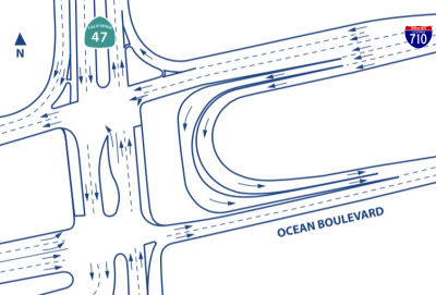 In July 2019, it was reported that an innovative traffic
feature of the new bridge under construction at the Port of Long Beach is
scheduled to open early on Saturday, July 20, 2019 enabling trucks and
other vehicles to make a safe and free-flowing U-turn at the west end of
the project. The “port access undercrossing” is a second
tunnel near the intersection of Ocean Boulevard and Route 47 on Terminal
Island. This “Texas U-turn,” so named because it’s a
common feature at intersections in the Lone Star state, enables vehicles
traveling on one side of a one-way frontage road to make a U-turn onto the
opposite frontage road without stopping at a traffic signal. Detour
for traffic on Pier T Avenue. With the opening of the new undercrossing,
trucks and other vehicles leaving the Pier T complex and heading east over
the existing bridge to reach the northbound I-710 Freeway will now take a
new route. Starting at 10 p.m. on Friday, July 19, construction crews will
permanently close the eastbound Ocean Boulevard loop onramp from Pier T
Avenue on Terminal Island. The closure is needed so crews can build new
roadways on the south side of Ocean Boulevard. The detour for all vehicles
headed east will take vehicles to the port access undercrossing. When
fully completed, the new cable-stayed bridge will include six traffic
lanes and four emergency shoulders, a higher clearance to accommodate
large cargo ships, a bike and pedestrian path with scenic overlooks, and
more efficient transition ramps and connectors to improve traffic flow.
In July 2019, it was reported that an innovative traffic
feature of the new bridge under construction at the Port of Long Beach is
scheduled to open early on Saturday, July 20, 2019 enabling trucks and
other vehicles to make a safe and free-flowing U-turn at the west end of
the project. The “port access undercrossing” is a second
tunnel near the intersection of Ocean Boulevard and Route 47 on Terminal
Island. This “Texas U-turn,” so named because it’s a
common feature at intersections in the Lone Star state, enables vehicles
traveling on one side of a one-way frontage road to make a U-turn onto the
opposite frontage road without stopping at a traffic signal. Detour
for traffic on Pier T Avenue. With the opening of the new undercrossing,
trucks and other vehicles leaving the Pier T complex and heading east over
the existing bridge to reach the northbound I-710 Freeway will now take a
new route. Starting at 10 p.m. on Friday, July 19, construction crews will
permanently close the eastbound Ocean Boulevard loop onramp from Pier T
Avenue on Terminal Island. The closure is needed so crews can build new
roadways on the south side of Ocean Boulevard. The detour for all vehicles
headed east will take vehicles to the port access undercrossing. When
fully completed, the new cable-stayed bridge will include six traffic
lanes and four emergency shoulders, a higher clearance to accommodate
large cargo ships, a bike and pedestrian path with scenic overlooks, and
more efficient transition ramps and connectors to improve traffic flow.
(Source: AJOT, 7/17/2019)
In October 2020, the new Gerald Desmond Bridge opened for traffic. The
following are some relevant statistics / pieces of information about the
new bridge:
(Source: Los Angeles Times, 10/2/2020, We Build Value Magazine, 8/29/2020)
In February 2022, it was reported that demolition on the old Gerald
Desmond Bridge is set to begin in May 2022. The old bridge opened in 1968
and is named after a former Long Beach city attorney who helped secure
funding to build the 5,134-foot-long span. It was decommissioned in
October 2020 when its replacement, also called the Gerald Desmond Bridge,
opened. Demolition operations on the old bridge will start with the
dismantling and removal of the main span — an operation that will
shut down the port’s Back Channel, a canal that runs under the
bridge, for a weekend. During that time, the old bridge’s main span
will be disconnected and lowered onto a barge. Full demolition is expected
to be concluded by the end of 2023. Demolition will cost $59.9 million,
which was included in the overall $1.47-billion budget used to build the
new bridge. The port awarded a contract in July 2021 to Kiewit West Inc.
to dismantle and remove main steel truss spans, steel plate girder
approaches, abutments, columns, access ramps, foundations and other pieces
of the old bridge. Metal and other materials removed from the old bridge
will be hauled to a recycling site for salvaging and reuse.
(Source: LA Times, 2/26/2022)
Demolition actually began in July 2022. During the last years of its use,
the original span carried around 68,000 California vehicles daily.
Demolition began with the operation to remove the suspended main span
section on the Back Channel, requiring a 48-hour closure of the channel to
all boat traffic. The plan is for the 125m-long span to be dismantled, cut
and lowered onto a barge. Dismantling and removal of the main spans, steel
trusses, steel plate connections, columns and access ramps will take until
the end of 2023. Funding for the nearly US$60 million demolition project
is included within the overall $1.57 billion budget that was allocated to
design and build the replacement bridge. The old bridge’s main span
was disconnected from the rest of the bridge and has been slowly lowered
the 50m in one piece to be placed onto a barge in the water.
(Source: World Highways, 7/14/2022)
In August 2023, the CTC approved a request for an additional $49,600,000 in Construction Capital for the SHOPP Bridge Rehabilitation and Replacement project on I-710 in Los Angeles County, to close out the construction contract. This project is located on I-710, in the City of Long Beach, near the Port of Long Beach (Port), at the Gerald Desmond Bridge № 53-3000, in Los Angeles County. The project (07-LA-710 3.7/6, PPNO 07-3037, ProjID 0700000379; EA 22830) replaced the bridge and is now named the Long Beach International Gateway Bridge. The project is funded through a combination of Federal, State, and Port sources. The original cost estimate, in July 2008, was based on a 30 percent level of design development of $950,000,000. In June 2011, this project was allocated $433,602,000 in Construction Capital and $66,398,000 Support in the SHOPP. In October 2012, the project was amended to revise $153,657,000 in Construction Capital in the SHOPP to Proposition 1B Corridor Mobility Improvement Account. In October 2016, the project received supplemental funds in the amount of $32,960,000 in Construction Capital and $15,000,000 in Construction Support. In March 2018, the project received supplemental funds in the amount of $19,206,000 in Construction Support. There are no remaining funds in Construction Capital. The project is 100 percent complete, and Construction Contract Acceptance was in February 2022, however additional funding is needed related to claims submitted by the contractor and settled by the Port. The requested amount represents the Department’s share of the settlement of all outstanding claims that were filed by the contractor and settled by the Port. The Port is the administrator of the contract, and the Department is a funding partner for the project. Construction began in October 2012, opened to traffic in October 2020, construction completed in December 2020, and the new bridge was transferred to the Department in March 2022. The Port issued 107 change orders during the design-build process resolving some disputes encountered during construction. However, a number of outstanding claims for extra work and time-related costs in excess of $250,000,000 remained unresolved as the project neared completion. The Department helped the Port by carefully examining the claims, and they found that the amount of $130,000,000 was reasonable. As a result, the Port went on to settle these claims with the contractor for that specific amount.
Route 710: Port of Los Angeles and Long Beach
Shoemaker Bridge Replacement (07-LA-710 PM 6.0/6.4)
") The 2018 STIP, approved at the CTC March 2018 meeting, appears to allocate $14,000K in Advance Project Development Element funds for PPNO 4071, Rt 710 S.Early
Action-replace Shoemaker Br (LA 6.402).
The 2018 STIP, approved at the CTC March 2018 meeting, appears to allocate $14,000K in Advance Project Development Element funds for PPNO 4071, Rt 710 S.Early
Action-replace Shoemaker Br (LA 6.402).
In August 2020, the CTC approved for future
consideration of funding 07-LA-710 PM 6.0/6.4 – Los Angeles
County Shoemaker Bridge Replacement Project. Replace bridge and
other improvements. (FEIR) (PPNO 4071) (EA 27300) (STIP). The Project will
replace the Shoemaker Bridge and add pedestrian, bicycle, and other street
enhancements. The project is located in the southern end of Route 710 in
the City of Long Beach. On April 21, 2020, the Long Beach City Council
adopted a Mitigated Negative Declaration for the Project and found that
the Project would not have a significant effect on the environment after
mitigation. The Project is estimated to cost $30,700,000 and is funded
through design with State Transportation Improvement Program Funds
($14,000,000) and Measure R Funds ($16,700,000). Construction is estimated
to begin in Fiscal Year 2022-23.
(Source: June 2020 CTC Agenda, Agenda Item
2.2c.(12); August 2020 CTC Agenda, Agenda Item 2.2c.(5); August 2020 CTC
Agenda, Agenda Item 2.5c.(5))
According to the City of Long Beach, the project
proposes to replace the Shoemaker Bridge (West Shoreline Drive) in the
City of Long Beach, California. The Shoemaker Bridge Replacement Project
(proposed project) is an Early Action Project of the I-710 Corridor
Improvement Project and is located at the southern end of I-710 in the
City of Long Beach and is bisected by the Los Angeles River. The purpose
of the proposed project is to improve existing traffic safety and
operations; increase multi-modal connectivity within the project limits
and surrounding area; enhance Complete Streets elements by providing
bicycle, pedestrian, and streetscape improvements on major thoroughfares;
and, address non-standard features and design deficiencies. Three
Alternatives are being evaluated as part of the proposed project:
(Source: Shoemaker Bridge Project Page; Shoemaker Bridge Environmental Impact Report/Environmental Assessment)
Alternatives 2 and 3 will include the evaluation of
design options for a roundabout or a “Y” intersection at the
easterly end of the bridge. The Build Alternatives would include bicycle
and pedestrian uses along the south side of the new bridge and also
provide improvements along associated roadway connectors to downtown Long
Beach, West Shoreline Drive from I-710, and portions of 3rd Street, 6th
Street, 7th Street, and West Broadway from Cesar E. Chavez Park to
Magnolia Avenue. The proposed improvements may include additional street
lighting, restriping, turn lanes, bicycle, pedestrian, and streetscape
improvements. Additionally, the Build Alternatives evaluate the impacts
from the closure of the 9th and 10th Street ramp connections into downtown
Long Beach.
(Source: Shoemaker Bridge Project Page; Shoemaker Bridge Environmental Impact Report/Environmental Assessment)
The Preferred Alternative, Alternative 3 (Design Option
A), includes the complete removal of the existing Shoemaker bridge and
construction of the new bridge with a roundabout on the eastern end of the
proposed bridge. Local road improvements would occur throughout the
Project limits including those on West Shoreline Drive, West 3rd Street,
Ocean Boulevard, Golden Shore/Golden Avenue, West Seaside Avenue, West
Broadway, West 6th Street, West 7th Street, West 9th Street, West 10th
Street, and Anaheim Street. The new Shoemaker Bridge would consist of
multiple structures, with spans that cross the LA River, the northbound
(NB) lanes of Route 710, and the LA River and Rio Hondo (LARIO) Trail. The
new ramps would be located approximately 500 feet (measured from
centerline) south of the existing Shoemaker Bridge.
(Source: Shoemaker Bridge Project Page; Shoemaker Bridge Environmental Impact Report/Environmental Assessment)
As of the time of the initiation of the project,
Shoemaker Bridge is under jurisdiction of the City of Long Beach and
serves as the extension of West Shoreline Drive within downtown Long Beach
to the I-710 corridor. I-710 transitions into Route 710 south of Pacific
Coast Highway. Since the existing Shoemaker Bridge is within City
right-of-way (ROW), the City serves as the lead agency under the
CEQA. However, since the new Shoemaker Bridge would require federal
funding and would be transferred to Caltrans for future ownership and
maintenance, Caltrans serves as a Responsible Agency under CEQA as well as
the lead agency under NEPA. The proposed Project is a stand-alone project
that proposes to address design and safety deficiencies associated with
the existing Shoemaker Bridge and improve circulation and
connectivity within downtown Long Beach. Even though the Project is a
stand-alone project, its design would accommodate the future construction
of the I-710 Corridor Project.
(Source: Shoemaker Bridge Project Page; Shoemaker Bridge Environmental Impact Report/Environmental Assessment)
In December 2023, it was reported that plans are being
released for a new $900 million bridge that is slated to replace the aging
Shoemaker Bridge and add 5.6 acres of park space to downtown Long Beach,
something the city hopes to complete by 2028. The new renderings show a
modern cable-stayed bridge with 240-foot tall angled arches that meet in
the middle of the 765-foot-wide bridge. Building the new structure is part
of a plan to realign Shoreline Drive, which would significantly change how
drivers enter and exit the I-710 Freeway. The current plans have cars
using a new roundabout that will circulate traffic onto the bridge, I-710
or city streets. Some other proposed features include a protected bike
lane that would connect Fashion Avenue to the Los Angeles River bike path
on the east side of the river as well as a pedestrian observation point on
the south side of the bridge that looks toward Downtown. The design shown
to the public has not been finalized. Long Beach received a $30 million
federal grant earlier this year for the realignment portion of the project
that will add northbound lanes alongside Shoreline Drive’s current
southbound lanes and eliminate the separate northbound section that has
left an unusable patch of green space west of Cesar E. Chavez Park for
decades. The city has estimated that part of the project will cost about
$60 million. Designs for the Shoreline Drive realignment are expected to
be completed in the spring with construction on the project expected to
start sometime in 2024 or 2025. The new bridge, which is expected to be
built just south of the existing Shoemaker Bridge, would be completed
before the old one is demolished to allow traffic to continue to enter and
exit Downtown during construction. The work will be completed in phases
with some of the park improvements projected to be among the last things
crews finish. The end result would connect Chavez Park to Drake Park,
which is north of Seventh Street. Once the bridge is complete, the Sixth
Street exit will be eliminated and Seventh Street will become a two-way
street to allow traffic to enter and exit I-710 through the new
roundabout. The bridge’s design is expected to allow more movement
for wildlife living in the river below because it will have fewer piers in
its base. The design is also expected to be able to withstand seismic
activity and sea level rise, according to the city.
(Source: Long Beach Post, 12/9/2023)
West Shoreline Drive
Note that West Shortline Drive, beyond the Shoemaker Bridge, is not part of the state highway system, but is maintained by the City of Long Beach. It serves as an extended off-ramp from I-710 into Long Beach.
The SAFETEA-LU act, enacted in August 2005 as the reauthorization of TEA-21, authorized $1,600,000 for High Priority Project #701: Develop and implement traffic calming measures for traffic exiting I-710 into Long Beach.
In February 2023, it was reported that the city of Long
Beach will receive $30 million to support redesign of West Shoreline
Drive, much of which is basically an extended I-710 off-ramp and currently
a major barrier and a safety hazard for local residents. That project will
reconfigure West Shoreline Drive, converting it to a landscaped local
roadway. Lanes will be consolidated, local Cesar Chavez Park will be
doubled in size, and traffic will be moved further away from two nearby
elementary schools. The changes will help create better, safer access
between nearby neighborhoods and community park space, Downtown Long
Beach, and other destinations. The funding is part of the Reconnecting
Communities Pilot program through the U.S. Department of Transportation.
The other cities receiving funds are Oakland, San Jose, Pasadena and
Fresno. The pilot program was established in the nation's Bipartisan
Infrastructure Law, which passed in 2021. Specifically, the grant includes
• Demolition of the existing northbound lane of Shoreline Drive;
• Relocation of major utilities; • Required temporary traffic
control and rerouting; • Major civil engineering and required
regrading; • Removal of old fences, hardscaping, and landscaping;
• Installation of new fiber, irrigation, and power conduits; •
Relocation of street lighting to accommodate new street and park
alignment; • Partial funding for the realigned roadway and new
medians at Shoreline Drive.
(Source: Streetsblog LA, 2/28/2023; Random Lengths News, 2/27/2023)
710 Corridor Mobility Improvements
The SAFETEA-LU act, enacted in August 2005 as the reauthorization of TEA-21, authorized $12,400,000 for High Priority Project #2178: Alameda Corridor East Gateway to America Trade Corridor Project, Highway-Railgrade separation along 35 mile corridor from Alameda Corridor (Hobart Junction) to Los Angeles/San Bernardino County Line.
![[Inst 710 Study]](logos/i710study.gif) Studies are currently ongoing (see the Gateway Council of
Governments, http://www.gatewaycog.org/) regarding improving mobility in the 710 corridor. The plan is controversal
('natch), for some proposals involve the acquisition and demolition of
nearly 700 homes and up to 259 businesses in Commerce, Bell Gardens, Bell,
Long Beach and other cities. As many as 10,800 people could be affected in
some way–of which 10,070 are minority residents. Commerce could lose
two of its four parks, Bandini and Bristow. However, the actual
improvement may be delayed due to the financial condition of the state,
for according to the Los Angeles Times in October 2003:
Studies are currently ongoing (see the Gateway Council of
Governments, http://www.gatewaycog.org/) regarding improving mobility in the 710 corridor. The plan is controversal
('natch), for some proposals involve the acquisition and demolition of
nearly 700 homes and up to 259 businesses in Commerce, Bell Gardens, Bell,
Long Beach and other cities. As many as 10,800 people could be affected in
some way–of which 10,070 are minority residents. Commerce could lose
two of its four parks, Bandini and Bristow. However, the actual
improvement may be delayed due to the financial condition of the state,
for according to the Los Angeles Times in October 2003:
"California's financial problems have stalled indefinitely a long-awaited $400- million plan to construct new barriers and shoulders along the Long Beach Freeway, sparking fresh concerns about safety on the truck-clogged route. The project would improve safety on most of the outmoded 24-mile freeway, including the area where six people recently died in a big-rig crash. Most of the freeway's medians and shoulders are narrower than state standards, and old wood-and-metal median barriers have not been replaced with the concrete barriers recommended for congested roadways with narrow medians, state Department of Transportation officials said. "
The project had been scheduled for completion in 2007. Most of the freeway has 16-foot medians, while current standards call for 22-foot medians. As for the shoulders, most of the freeway has 8-foot wide shoulders, while current standards call for 10-foot-wide shoulders. According to the LA Times article, I-710 carries 15% of the nation's seaborne cargo volume, or 47,000 trucks each day, a number projected to double or even triple in the coming years.
According to an article in the Los Angeles Times, in late January 2005, the Metropolitan Transportation Authority board approved a $5.5-billion plan to rebuild I-710, despite protests from residents. This plan would reconstruct an 18-mile stretch of the freeway from the harbors to rail yards in Commerce and East Los Angeles, transforming it from a 1950s-style road with six to 10 lanes to a modern 14-lane highway, with four lanes designed exclusively for trucks. Some portions of the truck lanes could be elevated. Construction would not begin until 2015 or later, and no one can say where funding would be found. Although most residents near the corridor agree the road needs to be rebuilt, many fear the project would create a massive truck artery without reducing air pollution. The Gateway Cities Council of Governments, made up of cities along the 710 corridor, made its first request to transportation officials to expand I-710 in 1999, and formal planning began a year later. But the process stalled in the spring of 2003, when residents learned that up to 800 homes could be demolished, and they accused officials of ignoring health concerns. The council then launched an elaborate process for community input. New design plans, meanwhile, call for the demolition of only five residential buildings and 61 industrial or commercial structures. Transportation officials say community health concerns will be addressed as part of the environmental review process, which could begin next year and take three to four years, at a cost of $35 million to $40 million.
In June 2006, the Metropolitan Transportation Agency Board of Directors authorized an environmental study of the project, which will cost $30 million and take three years. The ports of Long Beach and Los Angeles, the MTA, Caltrans and the Gateway Cities Council of Governments each contributed $5 million to help fund the study of the work; the overall project could cost up to $5.5 billion. The final project will involve building 10 mixed-flow lanes, four exclusive truck lanes, improving interchanges and arteries and direct truck ramps into railroad yards in Vernon and Commerce.
In December 2010, LA Metro provided an update. The environmental study was launched in 2008. Among the alternatives being studied for the project is widening the freeway to 10 lanes (five lanes in each direction); adding four elevated truck-only lanes adjacent to I-710 (two lanes in each direction); restricting the truck-only lanes to be used by trucks with zero tailpipe emissions; and possibly tolling the truck-only lanes. The goal is to release the study in Fall 2011.There are still money challenges. The construction cost of some of the alternatives ranges from $3.8 billion to $6.7 billion, depending on which alternative is selected. As part of the Measure R sales tax increase approved by L.A. County voters in 2008, $590 million is available for the I-710 project. In order to help address the funding shortfall, this project and five others, is being studied for a public-private partnership – i.e. deals in which private firms help pay for a project’s upfront cost in exchange for payments later. This is one reason the tolling option for trucks is being studied.
In June 2011, it was reported that the latest proposal would expand the 18-mile long roadway to 10 lanes without taking homes or disrupting adjacent Blue Line light- rail operations. Authorities expect the project to cost up to $8 billion and take more than a decade to complete, though tolls on trucks could significantly reduce public costs. The plan deviates significantly from a roundly dismissed proposal nearly 10 years ago that included destroying nearly 300 homes and businesses in North Long Beach and Compton, among other cities, to accommodate widening. The basic plan is to add new lanes on existing (electric) utility rights-of-way along the Los Angeles River, add a truck freight corridor, and improve interchanges and generally overall traffic flow. Traffic engineers expect truck traffic to increase from about 25,000 rigs per day now to as many as 90,000 daily by 2035. One proposal calls for adding a $10 toll on most large big rigs using a new, separated toll road during peak hours, generally from early morning to late afternoon, and $5 during off- peak hours. Passenger vehicles would not be taxed for using general-purpose lanes, though trucks using those lanes could be charged up to $20 per trip under details outlined in one plan. More details may be found at http://www.metro.net/710.
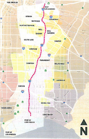 In June 2012, Caltrans released the Draft EIR for the mobility improvements. The defined alternatives assessed were:
Subsequent to the completion of the Alternatives Screening Analysis described above, the I-710 Funding Partners agreed that a tolling option should be added to the freight corridor component of Alternatives 6A and 6B to provide a possible revenue source to fund the improvements. This alternative is known as Alternative 6C. Alternative 6C includes all the components of Alternative 6B as described above and consists of the same footprint as Alternatives 6A and 6B. Further, this alternative would toll trucks using the freight corridor. Per Federal statute, unless otherwise excepted, all Interstate highways must be toll-free. However, current exceptions relating to tolling of Interstate highways include Value Pricing Pilot Program; Express Lanes Demonstration Project; the Interstate System Reconstruction and Rehabilitation Pilot Program; and the Interstate System Construction Toll Pilot Program. Should Alternative 6C be selected as the preferred alternative, tolling would be implemented pursuant to one of these exceptions.
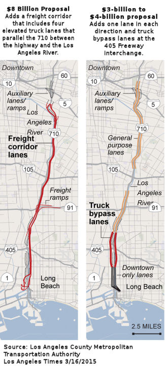 In August 2011, the CTC indicated that there were no comments to the Draft
EIR, that the Findings were accepted and that consideration of funding
should be brought forward to the CTC for approval of Public Private
Partnership funds.
In August 2011, the CTC indicated that there were no comments to the Draft
EIR, that the Findings were accepted and that consideration of funding
should be brought forward to the CTC for approval of Public Private
Partnership funds.
In February 2013, it was reported that, following thousands of comments from leaders within community health and environmental coalitions, the State-led project to expand I-710 from eight lanes to 14 lanes for 17 miles from Long Beach to Route 60 in East Los Angeles was delayed. The Project Committee, am advisory committee to Metro, Caltrans and the Southern California Association of Governments, halted the project with an astounding “no” on the proposed routes. Meanwhile, the Long Beach City Council I-710 Oversight Committee recommended that Caltrans and Metro recirculate the draft EIR, allowing for more public comment. At that meeting, two of the most exceptionally flawed alternatives–known as 5A and 6A–were recommended to be removed from the table.
In March 2015, it was reported that transportation officials are
considering two multibillion-dollar options to reconstruct an 18-mile
stretch of I-710 between the harbor and rail yards near I-5. Both are
designed to separate cars and trucks as much as possible. One alternative
under study by Caltrans and the Los Angeles County Metropolitan
Transportation Authority is an $8-billion freight corridor that includes
four elevated truck-only lanes that would parallel I-710 between the
highway and the Los Angeles River. The other option, which is far cheaper
at an estimated $3 billion to $4 billion, would add one lane in each
direction and a bypass that would take trucks around the I-405
interchange. I-710 now has anywhere from three to five lanes in each
direction. The proposals include extensive improvements to about a dozen
interchanges and redesigns of connector and ramp areas to eliminate
weaving caused by merging trucks and cars. Bikeways and walkways for
pedestrians also are under consideration. The two current proposals were
essentially split off from a broader 710 South project approved in 2005 by
MTA directors. That $4.5-billion proposal called not only for two elevated
truck lanes but also for interchange improvements and at least two regular
lanes in each direction. It would take about two years for the planning
and environmental work to be completed. Once an option is selected and
money is found, a construction contract could be awarded by 2018 or 2019.
(Source: Los Angeles Times, 3/16/2015)
In March 2016, the Los Angeles MTA presented its full proposal for what
transit lines could be built -- and when -- if Los Angeles County voters
approve a half-cent sales tax increase in November 2016. This proposal
included funding for the I-710 South Corridor Project. The project will
add 2 Zero Emission Truck lanes in each direction, from Pico/Anaheim in
Long Beach to Bandini/Washington in Commerce for a total of 18 miles,
while maintaining the current existing 4 Mixed-Flow lanes in each
direction.
(Source: Los Angeles Times 3/18/2016; Metro Board Report 3/24/2016)
In July 2017, it was reported that a new set of alternatives to improve
I-710 between Ocean Boulevard in downtown Long Beach and Route 60 was
released in an environmental document by Caltrans. One alternative would
add a general purpose lane to the freeway, while another would also create
a “Clean Emissions” freight corridor for use by zero emission
or near zero emission trucks. Both alternatives propose other safety
improvements to the freeway and interchanges, as well as air quality and
health benefits for communities along the corridor. The document’s
formal name is the Recirculated Draft Environmental Impact
Report/Supplemental Draft Environmental Impact Statement (RDEIR/SDEIS).
The RDEIR/SDEIS was prepared by Caltrans in cooperation with Metro, the
Gateway Cities Council of Governments, the Southern California Association
of Governments, the Ports of Los Angeles and Long Beach and the Interstate 5 Joint Powers Authority. The RDEIR/SDEIS may be viewed online at www.dot.ca.gov/d7/env-docs.
(Source: Metro "The Source", 7/20/2017)
In October 2017, it was reported that a public meeting on the EIR
highlighted the fact that the changes to the I-710 corridor will be the
hardest on the low-income areas of East LA. At the meeting, resident after
resident angrily said they are tired of not being listened to and their
East Los Angeles neighborhoods being forced to absorb the brunt of the
region’s transportation problems. County Supervisor Hilda Solis
represents neighborhoods and cities in the project area and sits on
Metro’s Board of Directors, and called the public meeting. She
briefly circulated among the crowd before the start of the meeting, which
she opened by saying her office, Caltrans and Metro are committed to
working with the community, but then left before the public comment
portion of the meeting. Eastside residents have long feared Caltrans and
Metro would take homes in their neighborhoods for the project and the
alternatives added in the recirculated report show it could happen. If
chosen, Options 3A and 3B under Alternatives 5 and 7 respectively, would
hit residents on Sydney Drive in unincorporated East L.A. near the
Commerce border the hardest. Dozens of homes could be slated for removal
or the freeway widened to within a few feet of their front door step. Also
potentially impacted are residents in the Ayers neighborhood in Commerce,
but the attention was on East Los Angeles, where the crowd had one message
for transportation officials, “Leave East L.A. alone.”
According to the presentation by Metro spokesman Ernesto Chavez, the I-710
project will improve traffic safety, air quality and prepare for growth in
the goods movement. It would also improve public health by reducing air
pollutants from trucks through the I-710 Clean Emissions Trucks Program.
However, the crowd had a sense of injustice, noting that plans to expand
the I-710 north through Pasadena and San Marino were scrapped because
those more financially well-to-do communities didn’t want the
disruption to their communities. The sense of injustice is not without
merit. It’s even acknowledged in the Draft EIR (S.5.3.3 –
Environmental Justice Build Alternatives), which cites
“disproportionately high impact and adverse impacts on minority and
low-income populations in the Study Area,” even after taking into
account the overall “beneficial effects” of the project
“on the surrounding communities and I-710 corridor users when
compared with current conditions.” Funding to “alleviate
project-related impacts to environmental justice communities” is
recommended. At this point, however, according to Chavez the biggest
obstacle to all of the proposals when it comes up for review in February
2018 is lack of funding. According to the I-710 Draft EIR, Alternative 5C
would cost $6.5 billion to build while Alternative 7 would cost $11
billion. Metro and Caltrans will provide $1.2 billion towards funding,
according to Chavez, leaving residents to question where the rest of the
money will come from. Work will be done in stages, explained Chavez,
meaning they don’t have to have all the money upfront. His words did
not sit well with residents like Sylvia Corona, who complained her
neighborhood would probably get the short end of stick. “The nicer
areas get all the funding,” the 42-year resident of East L.A. warned
her neighbors. “Once they reach East L.A. they’ll run out of
funds and we’ll be left to deal with the closure of roads, dust and
more traffic.” [Note: The injustice is well merited. Caltrans has
not treated low income neighborhoods in Los Angeles well in the past,
slicing through them with the Harbor and Santa Ana freeways.]
(Source: EGP News, 10/26/2017)
In February 2018, it was reported that, in a report to the agency's board
of directors, Metro staff urged support for a massive, $6-billion proposal that would add a lane in each direction along I-710 between Ocean Boulevard in Long Beach
and Route 60 in East Los Angeles. The price tag is one of the largest for
a freeway widening project in county history. The proposal calls for
changes to 24 major streets that cross I-710, as well as new interchanges
with Route 91, I-5 and I-405. A new, separated lane would allow truckers
to bypass commuter traffic near I-405. Transportation officials say the
widening is necessary because a soaring number of trucks is cramming each
day onto an inefficient route that needs to be modernized. Transportation and environmental activists — many of whom have fought the project for years — say Metro's preferred alternative would not do enough to
reduce emissions along a corridor known as the "diesel death zone" and
would displace people in some of Southern California's poorest and most
polluted areas. Caltrans and Metro would seize 109 homes and 158
businesses to expand the freeway, displacing an estimated 436 people.
Construction would have a disproportionate effect on poor residents who
are black and Latino, a Caltrans environmental analysis found. The
proposal has been under study for three years and is cheaper than the
other option Metro and Caltrans are considering: four elevated,
zero-emission truck lanes that would cost $10 billion and displace about
484 people.
(Source: LA Times, 2/13/2018)
A bit later in February 2018, it was reported that, as part of the $6 billion widening of I-710, a Metro committee is asking the transit agency to add a lane dedicated to electric vehicles — cars, buses and trucks — which would use wireless power transmission pads placed in the roadway to recharge their batteries as they travel. While wireless charging is being used at transit yards, including in the Antelope Valley to power electric buses, the notion of a freeway lane embedded with devices that continuously recharge a moving vehicle’s battery pack would be a first in the United States. Janice Hahn, an LA County Supervisor, noted in a written statement that these so-called “rechargeable roadways” are under construction today in China, Israel and Norway. By the time the 19-mile, I-710 improvement project, stretching from Long Beach to Route 60 in East Los Angeles, is complete in 2040, such technology will be commonplace, she said.
In March 2018, the Metro board acted on the recommendation: it
unanimously approved a plan to revamp I-710 from Long Beach to East Los
Angeles, but it’s holding off on the most costly and contentious
part of the plan: widening much of the route to five lanes in each
direction. Instead, the board approved fast-tracking portions of the plan
that would be cheaper to implement and wouldn’t result in
displacement for residents and business owners in areas close to the
freeway. The board still needs to nail down the projects, but they could
include parks, air filters in schools, and road improvements near the
freeway. The board also approved a motion to create a working group to
study how to reduce emissions along the entire 19-mile
freeway—notorious for its negative health effects on residents who
live close by. The board also asked Metro CEO Phil Washington to come up
with a plan to quickly phase out freeway access for smog-producing diesel
trucks, mandating instead that trucking companies use near-zero, and
eventually zero-emission, trucks to haul goods along the route. The
board’s decision pushes forward with the environmental review
process for a $6 billion project that would widen the freeway between
I-405 and Route 60, overhauling numerous entrances and exits along the
way. Funds for the full I-710 project aren’t yet in place, and
members of the board stressed that the decision does not give Caltrans a
green light to begin widening the freeway.
(Source: Curbed LA, 3/1/2018)
In November 2020, Metro released their recommendations for an early
action plan. The study identified four candidate segments: (1) Firestone
to Florence; (2) I-105 to Firestone; (3) Del Amo to Route 91; and (4) PCH
to I-405. The evaluation showed that the segment that should be addressed
first for the following reasons: (1) The comparative score is
significantly higher than the other candidates. (2) Potential
bottleneck relief and congestion reduction are the most significant
factors. (3) As an early action program, it is likely the most competitive
710 segment for grant funds, like TCEP. (4) The segment arguably provides
the best value, even if down-scoping is required by funding limitations.
In other words, PCH to 405 is the most deficient candidate with the
greatest need. In addition to recommended the PCH to 405 segment for early
action, Metro also recommended arterial street improvements at Atlantic
Ave, Alondra Blvd, Slauson Ave, and Florence Ave, active transportation
improvements, a clean truck program, soundwalls, and a community benefits
program.
(Source: Email "I-710 Corridor Project Update -
December 2020", 12/28/2020)
In May 2021, it was reported that, in a blow to Metro’s effort to
fast-track the I-710 Corridor Project, the federal Environmental
Protection Agency (EPA) has mandated that Metro follow air quality laws.
The EPA is insisting that Metro further study air quality impacts and the
steps Metro would need to take to mitigate them. For more than a decade,
Metro and Caltrans have been making plans to widen I-710 from downtown LA
to the port. Metro completed its initial study of the corridor in 2005.
Metro circulated its first draft 710 Freeway Corridor Project
Environmental Impact Report (DEIR) in 2012, then proceeded to release
revised versions of its DEIR in 2013 and 2017 – with another
revised/supplemental DEIR expected to be circulated in Summer 2021. In
2018, the Metro board approved a locally preferred alternative
(Alternative 5C) that would spend an estimated $6 billion to add two more
general purpose lanes. The approval was contentious, with environmental
justice and public health community groups strongly opposing the
expansion, which they claimed would demolish neighborhoods and worsen air
pollution in an already heavily polluted corridor. Metro did not then have
the funding for the entire $6 billion project, so the board directed staff
to only proceed with about $1.2 billion worth of an “early action
program.” Before Metro highway builders can proceed with early
components, the Metro board still has to approve the project’s DEIR
– to convert it from draft to final (FEIR). To finish the EIR,
federal laws and rules require Metro to do a thorough analysis of the
project’s impacts to air quality. For already-polluted areas, Metro
is required to do what is called a particulate matter (PM) hot spot
conformity analysis. Instead of actually thoroughly studying the
expansion’s air pollution impacts, Metro tried to do an end run
around the requirement. Metro trotted out a vague Clean Truck Initiative
program, and then asked the EPA to consider whether that program could get
Metro off the hook with regard to required air quality studies. In a March
letter, the EPA responded to Metro essentially saying “No – it
doesn’t work that way. Do the required analysis.” In response,
Metro CEO Phil Washington changed his agency’s stance on the
proposed $6 billion freeway widening project. After the federal
Environmental Protection Agency and the head of Caltrans came out against
the project, Washington committed Metro to bringing stakeholders together
to reimagine the principles of the project. Washington acknowledged
“the oftentimes disruptive harms created by major highway
construction” and the need to “address issues like congestion
and air quality and how investments are made.” The Los Angeles Times
noted that increasingly, federal, state and local highway officials are
acknowledging the harm of pollution, relocations and other effects of road
construction, especially on Black and Latino communities that have borne
the brunt of such problems over time.
(Source: Streetsblog, 5/4/2021; Streetsblog 5/18/2021; Los Angeles Times, 5/22/2021)
Also in May 2021, the LA Metro made clear that they haven't pulled the
plug on the expansion. County Supervisor Janice Hahn, a Metro board
member, said the agency needed to clean the air along the corridor by
electrifying trucks, pushing more port freight to the Alameda Corridor
railway and making other environmental improvements. But she contended
that I-710 would need continue to handle vital commercial traffic far into
the future. “We’re not demolishing this freeway,” Hahn
said. “But it is dilapidated. It has not kept up with the tripling
of cargo that we’re having at both of our ports.... Fifty percent of
the cargo that comes in there will always be trucked.” The board
ultimately endorsed further discussions between Metro and Caltrans over
the project’s future. Nevertheless, Metro board members and agency
officials indicated they would not support any expansions of the Route 710
corridor that involved displacing residents. Metro CEO Phillip A.
Washington said the agency had already set up meetings with California
Department of Transportation officials to discuss plans for to move
forward with all highway projects in the region.
(Source: Los Angeles Times, 5/27/2021)
That said, at its board meeting in May 2021, Metro took actions that made
the project close to death. The board unanimously approved two motions
reining in the Corridor Project that would widen the lower 710,
demolishing adjacent homes and businesses. One motion, spearheaded by
Boardmember Hilda Solis, called for Metro to “Immediately cease
further work” on the project. Boardmember Fernando Dutra sought a
30-day pause instead of ceasing work on the project. Ultimately Dutra
supported the motion when “cease” was changed to
“suspend.” Solis was adamant that Metro needed to stop
widening freeways in areas already heavily burdened by freeway pollution.
The other motion, spearheaded by Boardmember Janice Hahn, directs Metro
staff to report back on the EPA and Caltrans pulling the plug on the
project. Hahn expressed support for zero-emission improvements for the 710
corridor, but was reluctant to cease the project due to the need to serve
port traffic. Both sides expected that some off-freeway aspects of the 710
Freeway early action program (EAP) could proceed while the overall project
was suspended. With Metro’s main environmental studies nixed by the
EPA, the agency expects to start work on stand-alone environmental studies
for EAP.
(Source: Streetsblog, 5/28/2021)
In May 2022, the project officially died when the Los Angeles County
Metropolitan Transportation Authority unanimously voted to end the
$6-billion expansion plans for most of the I-710 Freeway. Metro’s
vote had long been anticipated as the plans to add a lane in each
direction along a 19-mile stretch of the freeway from Long Beach to East
Los Angeles had been on life support for years. Amid pressure from
residents, Metro, the lead agency on the plan, four years ago tabled a
scheme that would have displaced hundreds and added the lanes. But
planning continued. Last year federal environmental regulators struck a
serious blow to any hopes of widening. They found the plan could violate
the Clean Air Act, noting the region already had “the worst air
quality in the United States.” Those findings created a domino
effect and prompted the state’s top transportation official to drop
his support of the plan, puncturing all hopes that the project would move
forward. With no support from the state or federal agencies, Metro found
itself abandoned after spending hundreds of hours and more than $50
million in planning on a doomed project. And while plans have been put to
rest, the agency will need to grapple with what to do next. A plan by
Metro board member Janice Hahn approved Thursday will shift the $750
million in funds already secured for Route 710 to improvements for
Southeast Los Angeles communities along the freeway. It will also rename
the 710 Task Force, an advisory group for the agency, to reflect its new
direction. Already officials and residents are clamoring for projects. Air
filtration in schools, sound walls, access to the Los Angeles River and
new regional transit are among some of the pitches Hahn has already
fielded.
(Source: Los Angeles Times, 5/26/2022)
In February 2024, it was reported that Metro had released a Draft
Corridor Mobility Investment Plan. Metro already had sales tax funding -
over a half-billion dollars - set aside for Route 710. To determine how to
spend that money, Metro convened a stakeholder task force to come up with
a "multimodal corridor investment plan.". The proposal would widen I-710
in at least two places: adding new auxiliary lanes from Willow Street to
Wardlow Road, and from Del Amo Boulevard to Long Beach Boulevard. The
proposed plan also calls for retooling twelve ramp locations, called
"interchange improvements": I-710/I-105 interchange; I-710/I-405
interchange; Alondra Boulevard, with "modification" of the southbound
I-710 to Route 91 Freeway connectors; Anaheim Street; Del Amo Boulevard;
Firestone Boulevard; Florence Avenue; Imperial Highway; Long Beach
Boulevard; Pacific Coast Highway; Wardlow Road; and Willow Street. The
main tranches of funding would go to freeway/ramp/road expansion, plus
Goods Movement and Arterial Roadways/Complete Streets. From there, about a
third of the overall project funding would go to transit, active
transportation (walking and bicycling), and community programs. Note
that the actual draft plan is difficult to read, as they truly
bury-the-lede, filling the report with history and status, and putting
the recommendation at the end (hasn't Metro heard of an Executive
Summary). Most of this summary came from the Streetsblog report, after
filtering out their bias.
(Source: Streetsblog LA, 2/2/2024; Long Beach – East Los Angeles Corridor Mobility Investment Plan DRAFT
Recommendations, 2/23/2024)
Route 710 — Other Improvements
The SAFETEA-LU act, enacted in August 2005 as the reauthorization of TEA-21, authorized $5,500,000 for High Priority Project #3773: Reconstruct I-710 interchanges at I-405, at Route 91, and at I-105.
Route 91 Connector Vertical Clearance (07-LA-710 PM 12.6/13.0)
The 2020 SHOPP, approved in May 2020, included the
following Bridge Restoration item of interest (carried over from the 2018
SHOPP): 07-LA-710 PM 12.6/13.0 PPNO 4967 Proj ID 0716000017 EA 31910.
Route 710 in Long Beach, at the northbound Route 710 to eastbound Route 91
connector, below Artesia Boulevard Overcrossing No. 53-0820 and E91-N710
Connector Overcrossing No. 53-2241G. Lower profile of connector toachieve
standard vertical clearance. Programmed in FY20-21, with construction
scheduled to start in April 2022. Total project cost is $8,764K, with
$3,270K being capital (const and right of way) and $5,494K being support
(engineering, environmental, etc.),
(Source: 2020 Approved SHOPP a/o May 2020)
In June 2020, the CTC approved the following support
allocation for this project: 07-LA-710 12.6/13.0 PPNO 4967 ProjID
0716000017 EA 31910. I-710 in Long Beach, at the northbound Route 710 to
eastbound Route 91 connector, below Artesia Boulevard Overcrossing No.
53-0820 and E Route 91-N Route 710 Connector Overcrossing No. 53-2241G.
Lower profile of connector to achieve standard vertical clearance.
Allocation: PS&E $2,468,000; R/W Sup $43,000
(Source: June 2020 CTC Agenda, Agenda Item
2.5b.(2b) #22)
The Los Angeles Times provided more information the new pavement in an
article in September 2009. The project is called the "I-710 Long Life
Pavement Project", and started in 2001. Part of the problem is the traffic
load on the highway: On any given weekday, nearly 155,000 vehicles stream
north and south on the 710 past Pacific Coast Highway, 16% of which are
18-wheelers carrying up to 40 tons to and from the Port of Long Beach and
the Port of Los Angeles. The pavement is using a new asphalt mix, the
culmination of testing and experimenting that goes back to the 1960s. The
mix involves different types of asphalt being layered onto the roadway,
combined with significant thickness, almost 12 inches sitting upon the old
concrete roadbed. This approach serves to disseminate weight from the
point of impact, broadening and lessening the load into the deeper layers.
As the old concrete beneath the road jumps -- inevitable, beneath the
weight of moving traffic -- the asphalt flexes and recoils, preventing the
formation of cracks. In addition, pieces of rubber have been stirred into
the top layer to mute the sound of traffic and divert water to stop
hydroplaning. With regular maintenance, scraping and replacing this layer
every eight to 12 years, the pavement is expected to last at least 30
years (the typical asphalt pavement lasts 10 years, and concrete, such as
the design used for I-710, can last 40 years with maintenance).
(Source: Los Angeles Times, "A smooth idea for the 710 Freeway", 2009-09-30)
In August 2011, the CTC approved $190,222,000 in SHOPP funding for I-710 from South Gate to Monterey Park from Los Angeles River Bridge to Ramona Boulevard (~ LA 17.397 to LA 26.399) that will rehabilitate 37 lane miles of roadway to improve safety and ride quality. The project will also replace ramp pavement, widen inside and outside shoulders and nine bridges to standard widths, and replace existing median barrier with concrete barrier. Lastly, the project will construct maintenance pullouts to reduce worker traffic exposure.
In August 2011, it was reported that the Long Life Pavement Project will require a number of closures in late Summer 2011. Specifically, I-710 between I-105 and the Atlantic Boulevard exit (~ LA 21.965) will be completely shut down for several hours at a time two times per weekend on 10 consecutive weekends from August 5 through October 17, 2011. There will be no construction on Labor Day weekend. The full freeway closures in both directions will begin each weekend at 11:59 p.m. Fridays and run through 6 a.m. on Saturdays. They will begin again Sundays at 11 p.m. and run through 5 a.m. on Mondays. During the initial closure each weekend, moveable median barriers will be installed. They will guide motorists to shift to the northbound side of the freeway to commute in a reduced number of lanes while construction crews work on the southbound 710 over the weekend. During the final closure, the moveable median barriers will be removed in time for the Monday morning commute.
According to the Daily News, new pavement will be laid in a $164.5 million project along nine miles of I-710. The project includes shoulder reconstruction, new concrete barriers, a soundwall and widening of the Atlantic Boulevard undercrossing and of the southbound lanes at the Compton Creek bridge. Construction is scheduled to start in summer 2007.
 In November 2014, it was reported that a subcontractor
installed a new sign for the Olympic Boulevard exit (~ LA 23.428) that
read "Olimpic." A construction crew with the California Department of
Transportation spotted the mistake the next morning, but it was too late.
The misspelling was hard to miss, and drivers had already snapped and
tweeted photographs of the sign. Days later, a black tarp was thrown over
the sign in an attempt to cover the misspelling. The sign was one of many
improvements underway on I-710 as part of a pavement rehabilitation
project. The $120-million project, reaching from the Los Angeles River
Bridge to I-10, includes median barrier upgrades, shoulder widening and
the installation of fiber optics and precast concrete panels and slabs.
All costs associated with the removal, replacement and installation of the
Olympic Boulevard sign will be paid by the subcontractor who fabricated
the sign, not taxpayers or the state.
In November 2014, it was reported that a subcontractor
installed a new sign for the Olympic Boulevard exit (~ LA 23.428) that
read "Olimpic." A construction crew with the California Department of
Transportation spotted the mistake the next morning, but it was too late.
The misspelling was hard to miss, and drivers had already snapped and
tweeted photographs of the sign. Days later, a black tarp was thrown over
the sign in an attempt to cover the misspelling. The sign was one of many
improvements underway on I-710 as part of a pavement rehabilitation
project. The $120-million project, reaching from the Los Angeles River
Bridge to I-10, includes median barrier upgrades, shoulder widening and
the installation of fiber optics and precast concrete panels and slabs.
All costs associated with the removal, replacement and installation of the
Olympic Boulevard sign will be paid by the subcontractor who fabricated
the sign, not taxpayers or the state.
(Source: LA Times, 11/24/2014)
The CTC in November 2002 considered $8,540,000 in improvements to local streets in Los Angeles, Alhambra, and South Pasadena (07S-LA-710-26.7/32.1). This would be a grant to the cities to fund improvements.
Monterey Park to Pasadena (Constructed Portions)
No status updates.
Route 710 "Gap" Completion / Route 710 Corridor (I-10 to Valley Blvd to Del Mar / Northern Stub)
The 2013 Traversable Highways report notes: An eight lane freeway is planned after studies are completed. That never happened.
Michael Ballard has a page with pictures of the Route 710 gap and stubs.
The detail below summarizes a long-standing, highly contentious back and forth. The April 1998 Record of Decision sums it up well:
The California Route 710 Freeway project is not a typical highway project. It provides a vital link in the nation’s most severely congested freeway system. It also causes impacts of a magnitude that is unusual in today’s highway program. Both proponents and opponents of the project have pursued their respective interests very forcefully, with lawsuits on each side.
 Streetsblog-LA published a nice timeline of the Route 710 project. Another timeline can be found on the Metro site. South Pasadena also has a good timeline.
In 1933, the Department of Highways (DOH, later known as the California Department of Transportation or Caltrans) defined what was to become Route 710 as LRN 167. Here's the history of that route from this site's entry on LRN 167 (indented), with some additional annotation:
In 1933, the route from "Long Beach via Atlantic Boulevard to [LRN 26] near Monterey Park" was added to the state highway system. In 1935, it was added to the highway code as LRN 167, with the same routing.
In 1947 (1st ex. sess.), Chapter 11 kept the same endpoints, but introduced a discontinuity at (former) Route 245/US 101: "(a) Long Beach to [LRN 166]; (b) (a) above, near Los Angeles River to [LRN 26] via Atlantic Boulevard"
In 1949, Chapter 1467 combined the segments and extend the route to [LRN 205] (Pasadena Freeway): "Long Beach to [LRN 205] in South Pasadena"
In 1951, Chapter 1562 truncated the terminus to Huntington Drive: "… to Huntington Drive."
On July 24, 1953, the California Highway Commission adopted the location for the Long Beach Freeway from the Santa Ana Freeway to the Northerly terminus of the route at Huntington Drive.
In 1957, Chapter 1911 extended the origin to
[LRN 165] (Harbor Freeway): “[LRN 165] in San Pedro Long
Beach to Huntington Drive via Long Beach”
In 1958, Chapter 74 added the San Pedro-Terminal Island Bridge: "[LRN 165] in San Pedro to Huntington Drive via Long Beach, and including a bridge with at least four lanes from San Pedro at or near Boschke Slough to Terminal Island"
In 1959, Chapter 1062 extended to LRN 9: "[LRN 165] in San Pedro to Huntington Drive [LRN 9] in
Pasadena via Long Beach, and including a bridge with at least four
lanes from San Pedro at or near Boschke Slough to Terminal Island" (This
was the result of the 1959 freeway and expressway plan)
The Department of Highways began location studies in 1960. On April 21, 1960 the state formally notified the cities of Pasadena, South Pasadena, and Alhambra that studies were being initiated on the section of the Long Beach Freeway from Huntington Drive to the Foothill Freeway.
The first mention of the extension of the route to Pasadena is in 1961, when CHPW notes that the extension was defined by SB 480, and Advance Planning was starting to determine potential routes. In 1964, it was reported that planning was underway for the Long Beach Freeway (Route 7, now Route 710) from the Foothill Freeway, Route 134 and Long Beach Freeway Interchange to Norwich Avenue.
The Route 7 Era: Early Freeway Planning and Corridor Studies (1963-1993)
 In the 1964 "Great Renumbering", the legislature changed LRN 167 (which was signed as Route 15) to Route 7, and issued its Project Report VII-232 (dated 2/19/1964)
identifying seven alignments. In April 1964, the South Pasadena Review
published a map showing these alignments. The review noted that three of
the alignments would directly impact S. Pasadena. Route № 2 (the
Blue Alternative) extends from Mission Road in Alhambra and passes through
South Pasadena west of the Monterey Hills, then travels N through the
Arroyo Seco. Route № 6 (which is a variation of the Blue
Alternative), would pass W of the Monterey Hills and then slice through
the NE section of South Pasadena to roughly Columbia St. and Pasadena Ave.
Route № 3 is a modification of the Green Alternative. It would take
the freeway through South Pasadena E of the Monterey Hills Redevelopment,
following roughly Meridian Ave to Columbia St and N along Pasadena Ave
through Pasadena. Route № 3 would affect Braewood Hospital, the
South Pasadena Public Library, and El Centro Elementary School, and would
have the effect of dividing the city into two parts. Note that these
discussions were taking place before the route adoption of the
future Route 210 in the area that includes the curve from La
Cañada-Flintridge to the N.
In the 1964 "Great Renumbering", the legislature changed LRN 167 (which was signed as Route 15) to Route 7, and issued its Project Report VII-232 (dated 2/19/1964)
identifying seven alignments. In April 1964, the South Pasadena Review
published a map showing these alignments. The review noted that three of
the alignments would directly impact S. Pasadena. Route № 2 (the
Blue Alternative) extends from Mission Road in Alhambra and passes through
South Pasadena west of the Monterey Hills, then travels N through the
Arroyo Seco. Route № 6 (which is a variation of the Blue
Alternative), would pass W of the Monterey Hills and then slice through
the NE section of South Pasadena to roughly Columbia St. and Pasadena Ave.
Route № 3 is a modification of the Green Alternative. It would take
the freeway through South Pasadena E of the Monterey Hills Redevelopment,
following roughly Meridian Ave to Columbia St and N along Pasadena Ave
through Pasadena. Route № 3 would affect Braewood Hospital, the
South Pasadena Public Library, and El Centro Elementary School, and would
have the effect of dividing the city into two parts. Note that these
discussions were taking place before the route adoption of the
future Route 210 in the area that includes the curve from La
Cañada-Flintridge to the N.
(Source: South Pasadena Review, 4/6/1964 via Joel Windmiller,
2/19/2023)
During May 1964 hearings, it was suggested that the connection to I-210 be through Figueroa Canyon, but that was later dropped from consideration Following a couple of public hearings in Pasadena, the California Highway Commission (CHC) adopted the Green-Red-Green Line as documented in their report and findings dated 11/18/1964. This later was referred to as the “Meridian Route” (Huntington Drive to I-210).
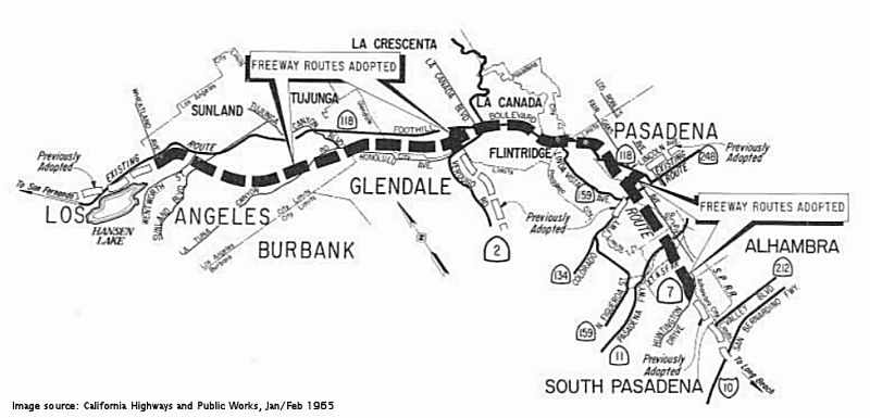 On June 3-4 1964, a routing was adopted for I-210, Route 134, and Route 710 (then Route 7). This routing extends the Long Beach
Freeway four mi N-ly to Route 134, and then extends I-210 N-ly to Sunland.
It also extends Route 2 to I-210. Starting at Huntington Drive, the route
proceeds N-ly to connect with Route 134/I-210, swings W-ly just S of
Devils Gate Dam and proceeding generally S of Foothill Blvd through the
Verdugo Mtns and across Big Tujunga Wash to Wheatland Ave. Also noticable
on the map is the inclusion of Route 159 (old Figueroa Blvd, and the
connection on Linda Vista between Route 134 and I-210), Route 248 (which
was the surface street routing of Colorado between Route 134 and I-210
near Monrovia), and Route 212 (which is the old Valley Blvd routing of US 60, former LRN 77). The legislative definitions were later amended to note
that Route 159 and Route 248 ceased to be state highways after I-210 was
completed. Note how this also still shows Route 118 in the area; that was
later renumbered to Route 210.
On June 3-4 1964, a routing was adopted for I-210, Route 134, and Route 710 (then Route 7). This routing extends the Long Beach
Freeway four mi N-ly to Route 134, and then extends I-210 N-ly to Sunland.
It also extends Route 2 to I-210. Starting at Huntington Drive, the route
proceeds N-ly to connect with Route 134/I-210, swings W-ly just S of
Devils Gate Dam and proceeding generally S of Foothill Blvd through the
Verdugo Mtns and across Big Tujunga Wash to Wheatland Ave. Also noticable
on the map is the inclusion of Route 159 (old Figueroa Blvd, and the
connection on Linda Vista between Route 134 and I-210), Route 248 (which
was the surface street routing of Colorado between Route 134 and I-210
near Monrovia), and Route 212 (which is the old Valley Blvd routing of US 60, former LRN 77). The legislative definitions were later amended to note
that Route 159 and Route 248 ceased to be state highways after I-210 was
completed. Note how this also still shows Route 118 in the area; that was
later renumbered to Route 210.
The Long Beach Freeway opened between I-10 and Valley Blvd. in February 1965. The City of Los Angeles signed the Freeway Agreement in April 1965. Alhambra followed suit in May 1966. In February 1967, the City of Pasadena approved the "straight through" alignment requiring taking the Neighborhood Church, as recommended by Victor Gruen Associates. This was the basis for the Freeway Agreement executed by Pasadena on March 30, 1967. This was the "Meridian Avenue Line". The Federal Highway Administration (FHWA) approved the state-adopted route in June 1967. South Pasadena requested a reconsideration, which was denied. Second and third requests for reconsideration in 1966 and 1967 were also denied.
In November 1969, the CHC directed the DOH to study the Westerly Route proposed by South Pasadena.
In the 1950s until 1978, Caltrans began purchasing more than 500 private houses and lots in Los Angeles, Alhambra, South Pasadena, and Pasadena with a plan to demolish them and build a surface freeway connecting Route 7 (later renumbered Route 710) in Alhambra to the I-210 in Pasadena.
The National Environmental Policy Act (NEPA) was signed into law in January 1970, and the California Environmental Quality Act (CEQA) was signed into law in November 1970.
DOH issued its Adopted Line Report in February 1972. Pasadena accepted the “Adopted Line” in March 1972. South Pasadena resolved to recommend the “Westerly Route” for the Route 7 (Route 710) extension in April 1972. CHC reaffirmed its adopted alignment the same month and concluded that the Westerly Route was not feasible in November 1972.
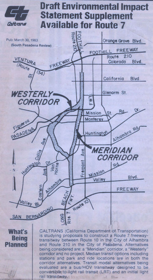 The California Department of Transportation (Caltrans)
was formed in January 1973 and released the EIR (I-10 to Huntington Drive)
the same month. South Pasadena, et.al. sued to stop construction, also the
same month, pending compliance with NEPA & CEQA. Construction was
enjoined in 1973. After the injunction was issued in 1973, FHWA and
Caltrans started the EIS process. The project has been analyzed in one
Draft EIS, three Supplemental Draft EIS’s, one Final EIS, seven
Section 4(f) Evaluations, and several Reevaluations.
The California Department of Transportation (Caltrans)
was formed in January 1973 and released the EIR (I-10 to Huntington Drive)
the same month. South Pasadena, et.al. sued to stop construction, also the
same month, pending compliance with NEPA & CEQA. Construction was
enjoined in 1973. After the injunction was issued in 1973, FHWA and
Caltrans started the EIS process. The project has been analyzed in one
Draft EIS, three Supplemental Draft EIS’s, one Final EIS, seven
Section 4(f) Evaluations, and several Reevaluations.
The Final Report, Alignment Selection, and The Injunction (1993-1999)
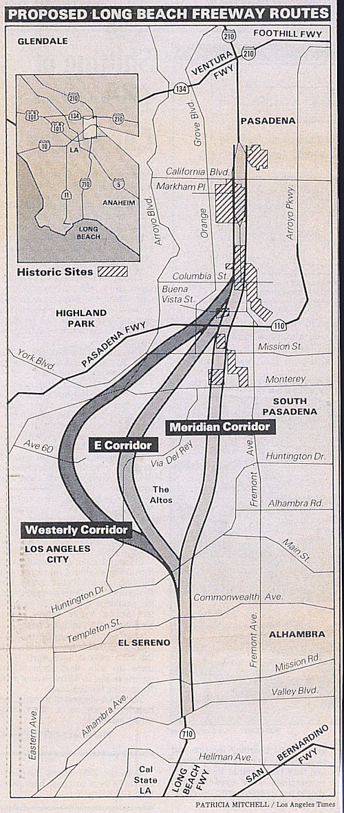 The June 1993 Final
Report from the Route 710 Meridian Variation Enhancement and Mitigation
Advisory Committee recommended several mitigation measures which were
adopted by Caltrans and resulted in changes to the preferred alternative
identified in the FEIS. The refined preferred alternative was then called
the Meridian Variation Alternative Reduced design variation. Notification
of the Meridian Variation Enhancement and Mitigation Advisory Committee
report availability was published in the Federal Register on July 9, 1993.
The basic revision was the reduction of the design width of the
facility’s cross section from 176 feet to 142, trucks were banned
from the freeway except for local deliveries and the elimination of a
proposed interchange between Route 710 and Route 110.
The June 1993 Final
Report from the Route 710 Meridian Variation Enhancement and Mitigation
Advisory Committee recommended several mitigation measures which were
adopted by Caltrans and resulted in changes to the preferred alternative
identified in the FEIS. The refined preferred alternative was then called
the Meridian Variation Alternative Reduced design variation. Notification
of the Meridian Variation Enhancement and Mitigation Advisory Committee
report availability was published in the Federal Register on July 9, 1993.
The basic revision was the reduction of the design width of the
facility’s cross section from 176 feet to 142, trucks were banned
from the freeway except for local deliveries and the elimination of a
proposed interchange between Route 710 and Route 110.
On January 15, 1993, before the Meridian Variation Enhancement and Mitigation Advisory Committee issued its Final Report, the Advisory Council on Historic Preservation (ACHP) referred the Route 710 project to the Council on Environmental Quality (CEQ) due to their concerns about the impact to historic properties and adequate evaluation of a Low-Build Alternative. The CEO did not accept the referral, but instead recommended that FHWA and ACHP work together on designing an acceptable methodology to update the historic inventory and to identify and evaluate one technically feasible Low-Build proposal.
After the Meridian Variation Enhancement and Mitigation Advisory Committee Final Report in June 1993, FHWA and Caltrans continued to seek ways to further reduce impacts of the project In a letter dated November 20,1995, the Keeper of the National Register determined that the Short Line Villa Tract Historic District was eligible for the National Register. Various design modifications, depressed profiles and alignment shifts were considered and reviewed in attempt to avoid and minimize impacts through this District. It was found that a shift in alignment will fully avoid any taking of the District. The shift will be about 400 feet from the original alignment at the widest point of departure. The 3700 feet (0.7 miles) of shift varies from zero feet near Huntington Drive to 400 feet near the Short Line Villa Tract Historic District and back to zero feet near Summit Drive. It has been determined that 116 properties (including a 43-apartment complex) which would have been taken by the original alignment would be spared. This design change is a further modification to the Meridian Variation Alternative Reduced design variation, and was referred to as the Meridian Variation Alternative Reduced with Shift design variation. Public outreach then occurred from December 27,1995 to January 11, 1996.
On October 3, 1997, a meeting of the impacted communities, key Federal agencies, and interested congressional representatives was held by the FHWA to discuss a potential approach for approving a Record of Decision (ROD) and advancing the project to final design. Based on comments received at that meeting and afterwards, the approach was refined and is incorporated in the April 1998 ROD. That decision was to select a modified version of the Meridian Variation Alternative as described in the FEIS, named the Depressed Meridian Variation Alternative Reduced with Shift design variation. This name reflects the adoption of the general alignment of the Meridian Variation Alternative with modifications that include a reduced highway width, a shift to avoid the Short Line Villa Tract Historic District and include a commitment to further depress the highway in the El Sereno and South Pasadena area. Each modification was based on a process to reduce overall impacts of the project. This selected alternative involves completing the Route 710 freeway gap between I-10, in the city of Alhambra and I-210 in the city of Pasadena, a distance of 6.2 miles (4.5 miles unconstructed). The freeway will also pass through the cities of Los Angeles (El Sereno community) and South Pasadena. The freeway will have six mixed-flow lanes and two high-occupancy-vehicle (HOV) lanes. Local service interchanges will be provided at various locations (Hellman Avenue and Valley Boulevard in the city of Alhambra, Alhambra Avenue/Mission Road and Huntington Drive in the city of Los Angeles, and Del Mar Boulevard in the city of Pasadena). The selected alternative will closely follow the alignment of the Meridian Variation Alternative identified as the preferred alternative in the FEIS. Starting on the southerly terminus at I-10, it will follow the alignment of the existing Long Beach Freeway northerly to Valley Boulevard. From Valley Boulevard to Huntington Drive, the alignment will generally parallel and run just west of the Los Angeles city limits. North of Huntington Drive, the alignment will approximately follow Meridian Avenue to Bank Street. At this point, the alignment will shift westward and run between Orange Grove Boulevard and Prospect Street north to the Arroyo Seco Parkway. The alignment will continue to parallel the now eastward-curving alignment of Orange Grove Boulevard to the Pasadena city limits, where it will continue shifting eastward to join with Pasadena Avenue at Madeline Street From here, the project will follow Pasadena Avenue north to Del Mar Boulevard, where it will connect to the existing Long Beach Freeway stub connecting to I-210/Route 134. The freeway is depressed for about 85% of the newly constructed 4.5 mile section and is fully depressed through Pasadena and South Pasadena except for the structure over Route 110. The freeway is depressed in virtually all of the residential areas. Approximately 25% of the 4.5 mile remaining gap closure is in cut-and-cover tunnels. There were loads of modification and conditions, all of which are detailed in the Record of Decision, April 1998.
The following were some of the alternatives in the FEIS, in addition to the "No Build" alternative:
Other alternatives that were eliminated as noted in the Record of Decision were:
In 1999 U.S. District Court Judge Pregerson issued a preliminary injunction prohibiting Caltrans from proceeding with the Route 710 Freeway Project. Judge Pregerson’s lengthy opinion identified numerous, substantial violations of federal law that would have to be remedied prior to completing the project, including violations of the Clean Air Act, Environmental Protection Act, and Historic Preservation Act. No attempt has been made by the defendants to satisfy the violations found by Judge Pregerson. FHWA rescinded their ROD IN 2003. In 2004 the CTC withdrew its Notice of Determination (NOD).
The New Millennium: Engineering and Updating the EIR (2000-2013)
Originally, construction of the the 6.2 mile, $670 million extension was planned to start after the year 2000. There would be six lanes and two HOV lanes, with room for light rail in the median. Interchanges are planned at Hellman Ave., Valley Boulevard/Alhambra Ave., Huntington Dr., California Blvd, Del Mar Blvd., and Green St. To decrease the impact on South Pasadena, the proposed interchange with I-110 has been removed. There are also two tunnels planned: a 1200-foot "cut and cover" near South Pasadena High School, and a 100-foot tunnel near the Buena Vista district. There may be more tunneling if this speeds the project without destroying homes. In fact, the MTA has asked a consultant to study two parallel, 4.5-mile tunnels to close the gap.
In 2002, with plans to build a surface road connecting the two freeways
shelved, Caltrans decided to move forward with a tunnel alternative. In
2004, the Metropolitan Transportation Authority selected a team of
consultants, led by the engineering firm Parsons, Brinkerhoff, Quade &
Douglas to conduct a feasibility study for the tunnel. The narrow scope of
the study focused on connecting the freeway stubs in Alhambra and
Pasadena, and failed to analyze the needs of the surrounding region. Metro
issued its Route 710 Tunnel Technical Feasibility Assessment Report in
2006.
(Sources for the above: Record of Decision, April 1998; WestPasadena
Residents Association, Response to DEIR (Historical Overview),
8/3/2015; Long Beach Freeway, Route 710 (formerly Route 7), Los Angeles County Draft EIS, 12/23/1974; LosAngeles
Times, 4/27/1986; Long Beach Freeway, Route 710 (formerly Route 7), Los Angeles Final EIR, Volume 2, 1992; Route710
Third Draft EIR Supplement, 1986)
In April 2004, the Pasadena Star News reported that the city of South Pasadena dropped its lawsuit against the state after receiving assurances that the state had withdrawn its approval of the 4.5-mile stretch of road. Although South Pasadena believed this killed the freeway, it actually moved the issue into the Legislature and the Congress. The only thing about which both sides agree is that the California Transportation Commission action put the entire issue back to square one. The California Transportation Commission withdrew its support four months after the Federal Highway Administration issued a letter saying that the state's environmental reviews were outdated, inadequate and had to be redone. Caltrans has said it intends to move forward with the new environmental reviews. Caltrans still holds 600 homes in the 710 corridor, and it still says it intends to demolish them so that the freeway can be built.
The SAFETEA-LU act, enacted in August 2005 as the reauthorization of TEA-21, authorized $2,400,000 for High Priority Project #2193: I-710 Freeway study to evaluate technical feasibility and impacts of a Tunnel Alternative to close I-710 freeway gap. It also authorized $1,600,000 for High Priority Project #3018: Valley Boulevard (former US 60) Capacity Improvement between I-710 Freeway and Marguerita Avenue, Alhambra. This is the route that takes the current end-traffic from I-710.
According to an article in the Los Angeles Times on 10 August 2005, a potential solution to the completion of I-710 lies in the SAFETEA-LUA bill approved in August. This bill contains an appropriation of $2.4 million to study the possibility of extending the freeway through a five-mile, $2-billion tunnel that would run under South Pasadena and part of Pasadena. This would be the longest continuous highway tunnel in the United States. After the feasibility study would be environmental impact reports, engineering plans and financial wrangles. Part of the problem is real estate values. Over the last 30 years, Caltrans purchased more than 500 homes that occupy the potential freeway right of way, many at prices in the $50,000 range. One was recently appraised for $780,000. Building a tunnel would allow Caltrans to sell most of the homes, although a change in state law would be needed to sell them at full-market prices. If the freeway were to be completed above ground, an additional 400 homes would need to be purchased, at a price of about $1 million each. These costs (or income), combeind with new techniques pioneered in Europe that lower the price of tunneling and the cost to taxpayers of putting the road 100 feet to 200 feet below ground may be not much more expensive than building on the surface. The five-mile tunnel, if built, would begin where the freeway ends in a stump on Valley Boulevard in Alhambra. It would surface between California and Del Mar avenues in Pasadena before connecting to a mile strip of the freeway that already exists south of the Foothill Freeway. Engineers said the tunnel would be unbroken, except for a possible interchange at Huntington Drive in El Sereno. The route would be nearly twice as long as Boston's Big Dig or a similarly long passageway in Alaska, the longest road tunnels in the United States. Exhaust from the underground roadway would be released and filtered through an elaborate venting system at ground level. The so-called air scrubbers would filter enough of the exhaust that it could actually result in cleaner emissions than with a surface freeway. Engineers said the tunnel could have two levels – one for northbound traffic, the other for southbound traffic. The tunnel idea has already been the subject of a study by the Southern California Council of Governments, which enlisted help from consultants who built the Chunnel that links England and France below the English Channel. The consultants believed the tunnel could be built using a technique popular in Europe in which a large machine bores through the Earth and coats the tunnel way with a steel membrane That technique is considered less expensive than other tunnel-digging methods.
According to the Los Angeles Times in June 2006, there are three possible routes for twin 4½-mile tunnels that would connect I-210 in Pasadena with current terminus of I-710 in Alhambra. The proposed tunnel routes are:
The tunnels would be as much as 72 feet in diameter to handle four lanes of traffic, and would be the world's largest. Parsons Brinckerhoff compared the proposal to giant tunnels being built underneath Seattle, Paris and Barcelona, Spain, and calculate that the L.A. tunnels would take nine to 11 years to construct. The study recommended that trucks be allowed to use the tunnels and that a proposed freeway exit at Huntington Drive be abandoned as too costly at an estimated $1 billion. The tunnels may require a toll to help pay for construction. The full report can be found at http://www.mta.net/images/710_final_report.pdf.
In May 2007, the Los Angeles Times reported that there are plans for a $20M project to create a connector from the current end of I-710 around Valley Boulevard to Mission Road. Supposedly, the City of Los Angeles will soon (Spring/Summer 2007) release a draft Environmental Impact Report on the project. The connector road would carry traffic another 1,400 feet from I-710 onto Mission Road, possibly sending 40,000 cars daily winding through residential streets like Westminster and Meridian Avenue. The road would alleviate traffic problems through some El Sereno neighborhoods, according to Los Angeles officials, but create others as Mission, a collector street, is not as wide as Valley, an arterial street. This road would be needed only until I-710 is completed and connected to I-210.
In April 2008, a radical proposal surfaced regarding Route 710. This
proposal would have the underground highway funded entirely by the private
sector. Metro officials have confirmed they have been approached by a
financial broker representing major international corporations interested
in investing in the plan, which would use giant tunnel-boring machines to
build a completely subterranean 6-mile, multi- lane roadway. The route
would link the current terminus of the northbound I-710 in Alhambra with a
short northern Route 710 segment of the freeway in Pasadena. The
discussions are very preliminary and more details about the plan need to
be hashed out before a private-partnership could even be considered. Under
some public-private partership agreements, the private contractor pays for
and builds the infrastructure in exchange for future revenues, such as
fees collected through tolls. This latest proposal addresses all the
concerns of South Pasadena residents and elected officials, by being
entirely subterranian, not cut and cover. However, Route 710 extension
plans also have to contend with opposition from nearby La Cañada
Flintridge, which has objected to any proposed tunnel plans because of
officials' fears of increased traffic on I-210 through their city.
(Source: Whittier Daily News, April 7, 2007)
![[710 Tunnel Study]](maps/710-tunnel-study.jpg) In January 2009, Caltrans and the LA MTA conducted
geotechnical exploratory borings in two locations in the City of Alhambra.
This is part of the Exploration Program phase of the two-year I-710 Tunnel Technical Study that will involve research, exploration and technical analysis of the soil and sub-surface conditions found while
tunneling at depths of more than 250 feet. The net goal is to see whether
construction of the I-710 tunnels is feasible. The map of the routes being
explored is show to the right.
In January 2009, Caltrans and the LA MTA conducted
geotechnical exploratory borings in two locations in the City of Alhambra.
This is part of the Exploration Program phase of the two-year I-710 Tunnel Technical Study that will involve research, exploration and technical analysis of the soil and sub-surface conditions found while
tunneling at depths of more than 250 feet. The net goal is to see whether
construction of the I-710 tunnels is feasible. The map of the routes being
explored is show to the right.
The purpose of the study is to examine the possibility of constructing a tunnel to complete the route between the northern I-710 termini and the Foothill Freeway (I-210). The study is being conducted in a route neutral manner. This means that all reasonable and practicable alternatives for completing the route are being considered within the Study area, which encompasses the cities of Alhambra, Glendale, La Cañada-Flintridge, Los Angeles, Monterey Park, San Marino, South Pasadena and Pasadena. Information gathered throughout the Study will describe soil and sub-surface conditions and will determine the feasibility of building a tunnel to complete I-710.
In 2009, the LA Times reported that the tunnel study was completed. The
study explored five zones, and concluded that a tunnel would be feasible
(which is a far way from the start of construction). The draft report will
be finalized in 2010, was based on the assumption that the tunnel would be
about 200 feet below ground and about 50 feet in diameter. It looked at
five potential construction zones:
(Source: Los Angeles Times, 11/17/2009)
Zone 1 (Northeast L.A.): There is one Superfund site in the northwest portion of the zone which could be a source of contaminated soil and groundwater in the tunnel. There is also a possibility of encountering naturally occurring gases such as methane and hydrogen sulfide. There are no active faults in the zone.
Zone 2 (Northeast L.A.): The active Raymond fault crosses the zone and there is also the potential of encountering naturally occurring gases. Some soil and groundwater contamination could result in hazardous materials being encountered.
Zone 3 (South Pasadena/Pasadena): The Raymond and San Rafael faults are groundwater barriers in this area, and there is one active and two potentially active faults in the area. There are two places with minor soil contamination in the northern limits of the zone.
Zone 4 (San Marino/Pasadena): Active faults that cross the zone are the Raymond and Alhambra Wash faults. There is one Superfund site in the southwestern end of the zone. There are also six other sites with various levels of soil contamination.
Zone 5 (Alhambra/San Gabriel/Temple City): The active Alhambra Wash fault is in this zone and so are the perennial Rio Hondo and San Gabriel rivers. There is one Superfund site in the south-central portion of the zone and seven other sites with various levels of soil and groundwater contamination.
The Glendale News Press reported that the debate over the alternative, an
underground tunnel, was reinvigorated in late 2009 when Caltrans and Los
Angeles County Metropolitan Transportation Authority released a $6-million
route feasibility study. The report showed tunneling was feasible within
five potential route zones, which include connections to I-210 and Route 2. That sparked a wave of renewed protest from local stakeholders, who
said the perception that plans for a 710 connector was too far flung and
expensive didn’t match with what was happening in political circles.
Already, $780 million in Measure R sales tax revenue has been earmarked
for the connector. And in January 2010, the MTA instructed officials to
explore private partnerships for additional funding. The next step is a
series of community meetings for the final draft of the technical study,
which will be presented this spring to the MTA and California
Transportation Commission, which will decide whether to move forward with
more in-depth environmental studies. Tunnel opponents argue there are
better ways to address what they contend is largely a commercial freight
issue. Assemblyman Anthony Portantino (D-Pasadena) said moving to the
environmental study process would be a misuse of millions in taxpayer
dollars. He also criticized the technical study for lacking important
details on how and why tunneling is feasible, including costs and
construction methods. La Cañada and South Pasadena are in court
fighting the use of Measure R funds for tunnel studies or construction,
and the Glendale City Council joined the legal fight in early March.
(Source: Glendale News Press, February 2010)
Details on the Tunnel Study may be found at https://www.metro.net/projects/sr-710-conversations/.
In October 2011, it was reported that LA Metro approved a $37.3 million contract to CH2MHill to examine a range of alternatives, prepare technical assessments, and environmental and engineering studies about alternatives to close the gap between the Route 210 and Route 710 freeways. The studies are expected to be completed in the fall of 2014.
In January 2012, it was reported that South Pasadena was lobbying to kill the surface routing of Route 710. LA Metro was indicating they had no plans to construct a surface routing, but didn't want to pull it off the table as an option quite yet. The city is also lobbying Caltrans to sell the more than 500 homes the agency bought decades ago along the proposed route in preparation for building the Route 710 Freeway extension to connect with I-210. In particular, at the request of Assemblyman Anthony Portantino (D-La Cañada Flintridge), a Joint Legislative Audit Committee is conducting an inquiry into Caltrans’ continued ownership of the homes. The state stands to gain $500 million if it sells the homes in Pasadena, South Pasadena and Los Angeles. However, Caltrans is not able to sell the homes until the Federal Highway Administration accepted the proposed route for a tunnel or whatever project was approved and the state determined which properties were "excess" and therefore available to be sold. If they are sold, under a state law passed in 1979, current tenants and past owners would be the first in line to buy them.
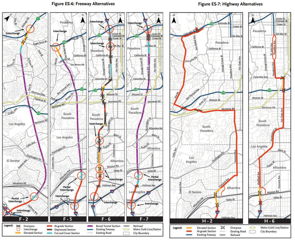 In May 2012, it was reported that debate was still going on regarding
alternatives. There are currently twelve alternative concepts to relieve
traffic congestion, including a “no build” freeway option and
other projects still listed in the Regional Transportation Plan. Those
options include alternate bus, light rail and freeway routes, highway and
street artery concepts, non-infrastructure improvements and hybrid
combinations of the other plans. All of the freeway alternative concepts
will connect the terminus of I-710, north of I-10. The alignment can be a
tunnel, depressed, at-grade, elevated or any combination. The LRT-4
concept proposes a partially subterranean light rail line that would
travel from the East LA Civic Center Gold Line station to the Fillmore
station, go north on Mednick at street level and it could stop at Cal
State LA. The rail is a tunnel on the north end; the concept also includes
two bus routes. The freeway alternatives are:
In May 2012, it was reported that debate was still going on regarding
alternatives. There are currently twelve alternative concepts to relieve
traffic congestion, including a “no build” freeway option and
other projects still listed in the Regional Transportation Plan. Those
options include alternate bus, light rail and freeway routes, highway and
street artery concepts, non-infrastructure improvements and hybrid
combinations of the other plans. All of the freeway alternative concepts
will connect the terminus of I-710, north of I-10. The alignment can be a
tunnel, depressed, at-grade, elevated or any combination. The LRT-4
concept proposes a partially subterranean light rail line that would
travel from the East LA Civic Center Gold Line station to the Fillmore
station, go north on Mednick at street level and it could stop at Cal
State LA. The rail is a tunnel on the north end; the concept also includes
two bus routes. The freeway alternatives are:
In August 2012, Metro and Caltrans eliminated 5 routes from the list of 12 possible routes:
The five remaining proposals include routes using bus rapid transit, light rail, or freeway tunnel and intelligent traffic systems (which includes strategies such as ride sharing and encouraging off peak traffic). The remaining alternatives are:
In September 2012, the Los Angeles city council voted to opposed any extension option -- surface or tunnel.
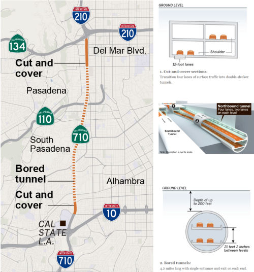 In January 2013, the LA MTA released its analysis of the first options above.
In June 2013, MTA voted to block fast-track funding for the the route
extension over the next 10 years. While the proposal to extend I-710 to
I-210 will be prevented from getting a share of the $9.4 billion in
accelerated funding, studies on five alternatives for closing the gap,
including a controversial proposal for a tunnel, will continue. The
studies are expected to be completed in 2015, but money to move forward
after that has not been identified. Officials are using money generated by
Measure R, a county-wide half-cent sales tax approved by voters in 2008,
to pay for the studies.
In January 2013, the LA MTA released its analysis of the first options above.
In June 2013, MTA voted to block fast-track funding for the the route
extension over the next 10 years. While the proposal to extend I-710 to
I-210 will be prevented from getting a share of the $9.4 billion in
accelerated funding, studies on five alternatives for closing the gap,
including a controversial proposal for a tunnel, will continue. The
studies are expected to be completed in 2015, but money to move forward
after that has not been identified. Officials are using money generated by
Measure R, a county-wide half-cent sales tax approved by voters in 2008,
to pay for the studies.
In October 2013, a bill was approved directing Caltrans to sell some of
the nearly 500 properties it owns in Los Angeles, South Pasadena and
Pasadena. The homes are located in the so-called 710 gap, where
transportation officials are studying a 4.5-mile tunnel that would connect
the Long Beach (Route 710) and Foothill (I-210) freeways. The bill adds a
change to existing law so that the homes may be sold “as is,”
at prices set according to their condition, as opposed to having to be
repaired and sold at market value. Almost 400 homes are occupied by
tenants, but many others remain vacant and in disrepair. The bill also
states the current tenants of the homes will get the first chance to
purchase them. The properties were acquired by Caltrans over the past
several decades in anticipation of the possible construction of a surface
freeway to close the gap between Route 710 and I-210 freeways. The new law
also states that the surface freeway route will be taken off the table as
an option in any state environmental documents on the project (the
original surface routing is shown at the top of this entry).
(Source: Glendale News-Press, 10/2/13)
In October 2014, it was reported that authorities are considering
completing Route 710 with 4.9-mile-long twin tunnels. Light rail, enhanced
bus service and wider streets are also being explored. The 4.9-mile-long
tunnel would be longer than any other in California for auto traffic. As
of October 2014, the longest is the Wawona Tunnel in Yosemite National
Park, which is less than 1 mile long. Caltrans and Metro will release a
draft environmental report in February 2015 evaluating the freeway tunnel,
mass transit and street-widening options; the public will have three
months to provide comment.
(Source and Graphic: Los Angeles Times, 10/20/2014)
In March 2015, it was reported that any major modifications to the
unfinished Route 710 Freeway would cost billions of dollars and take years
to complete. The Draft EIR provides a number of options to address the
4.5-mile gap through Alhambra and South Pasadena, including a bus system,
a light-rail line, a freeway tunnel and a range of upgrades to the
existing route, as well as the required "no build" option. Building an
underground freeway would be the most expensive option. Tunneling between
I-10 Freeway and the current stub Route 210/Route134 junction in Pasadena
would cost between $3.1 billion and $5.6 billion and would take about five
years to complete. This option calls for side-by-side, double-decker
tunnels to separate northbound and southbound traffic. The route would
feature a 4.9-mile tunnel and 1.4 miles of surface-level freeway. A less
expensive option calls for one double-decker freeway tunnel. Northbound
traffic would use the two lanes on the upper level, and southbound traffic
would use the lower level. The 4.9-mile tunnel would be the longest in
California, and almost as long as downtown Boston's 5.1-mile Big Dig
tunnel. Under either option, drivers could be charged a toll and trucks
could be barred from the tunnels. Alternatively, the bus option provides a
12-mile rapid bus route linking Huntington Drive in San Marino to Whittier
Boulevard in Montebello. Buses would have some dedicated lanes, and could
run every 10 minutes during peak hours. Adding the bus routes would cost
$241 million and take about two years. Lastly, a 7.5-mile light-rail line
option would cost $2.4 billion and would add seven stops to Los Angeles
County’s growing rail system, connecting the Gold Line’s
Fillmore Station in Pasadena with the East L.A. Civic Center stop. The
route would run underground through Pasadena and South Pasadena, then run
on elevated tracks through Monterey Park and East Los Angeles.
Construction would take about six years. The cheapest option would be to
make the existing freeways and roads more efficient without major
construction. That could include meters for on-ramps, synchronized traffic
signals, and lanes that change direction during peak hours. Those options
would cost about $105 million and take two years to complete. Caltrans was
scheduling a number of open forums to get comments from the public.
(Source: LA Times, 3/6/2015)
In June 2015, it was reported that Beyond the 710, a coalition of community organizations, environmental attorneys, five San Gabriel Valley cities, and the National Trust for
Historic Preservation, had submitted a plan that eschewed additional
highways and tunnels, and proposed instead the notion that expanding bus
service, improving surface streets, adding bicycle routes and developing
more walkable communities would better address traffic congestion, air
pollution and the transportation needs of the west San Gabriel Valley.
Instead of constructing the extension, Beyond the 710 envisions building
several local surface-street projects, including a four-lane thoroughfare
called Golden Eagle Boulevard that would head 1.9 miles north from the
southern stub of Route 710 to Fremont Street in Alhambra. Golden Eagle
would intersect Valley Boulevard, Alhambra Avenue and East Mission Road,
allowing traffic to be distributed to other surface streets, thus
protecting residential neighborhoods. The northern stub of Route 710 in
Pasadena would be filled in, providing35 acres of open space or
developable land for homes and commercial buildings. They also proposed a
north-south transit corridor that meanders along the Route 710 route and
would connect to major destinations as well as Metrolink service, the El
Monte busway and the MTA’s Gold, Green and Blue light-rail lines.
(Source: LA Times, 5/28/2015)
In June 2015, the CTC received the opportunity to provide comments in response to the Draft Environmental Impact Report (DEIR) for the Route 710 North Study Project. The opportunity came with numerous letters from community officials and citizens recommending that the CTC take no position until a preferred alternative had been selected by Caltrans. These included letters from Assemblyman (Ret.) Anthony J. Portantino, the City of South Pasadena, the City of La Canada-Flintridge, the West Pasadena Residents Association, Gloria Valladolid, Melissa Michelson, and the No 710 Action Committee. The recommendation, which was accepted, was that the CTC make no comments regarding the environmental issues addressed in the DEIR. The recommendation also noted that the CTC should send a letter to Caltrans stating that (a) The Commission has no comments with respect to the alternatives or environmental impacts addressed in the DEIR; (b) The final environmental document should not be brought forward to the Commission for project funding decisions or other purposes until a cost benefit analysis is distributed through a process that ensures sufficient opportunity for the public to review and provide comment; (c) Early communication and coordination with the Commission is encouraged if it is anticipated that the Commission will be requested to approve the project for delivery through a public private partnership or for construction approval to allow for financing and tolling approval by the California Transportation Financing Authority; and (d) If, in the future, funds or other actions under the purview of the Commission are anticipated ,notification should be provided to the Commission as a Responsible Agency. The initial letter from Caltrans noted that the project is not fully funded: it has $780,000,000 in local funding available and the agency is working to identify additional funds. Depending on the alternative selected, the total estimated project cost is between $105,000,000 and $5,650,000,000.
In August 2015, it was reported that the South Coast Air Quality
Management District said the draft environmental impact report for the
proposed Route 710 Freeway extension failed to estimate emissions of
carbon monoxide and airborne particulates and that the tunnel project
would raise the cancer risk to unacceptable levels. The eight-page letter
from Ian MacMillan, the anti-smog district’s planning and rules
manager, says the lack of basic air quality analysis renders the draft EIR
useless to the agency or those deciding on a tunnel or other transit
options. One part of the EIR places the cancer risk of the project at 149
chances per million people exposed to pollutants, well above the
district’s standard threshold of 10 chances per million. Yet, the
report concludes that the cancer risks are “less than
significant” based on faulty data. The agency has requested that
Caltrans and the Los Angeles County Metropolitan Transportation Authority
or Metro, which paid $40 million for the study released in March, revise
the air quality portion of the document.
(Source: SGV Tribute, 8/13/2015)
In August 2015, it was also reported that group representing San Gabriel
Valley cities has removed the Route 710 freeway tunnel proposal from its
wish list of projects that might be funded by a new transportation sales
tax. The decades-old idea of extending Route 710 Freeway north from its
Alhambra terminus near Cal State Los Angeles to I-210 Freeway in Pasadena
via an underground tunnel has been divisive. Alhambra wants a tunnel,
Pasadena doesn't. Other cities have taken sides. Now all 31 San Gabriel
Valley cities united in taking the tunnel and other proposals for speeding
traffic through the western valley off the list of projects that would
have priority for funding with a potential new transportation sales tax.
The vote by the San Gabriel Valley Council of Governments does not kill
the tunnel idea, but it has the potential for limiting the means of paying
for its construction, estimated by Caltrans at more than $5 billion.
(Source: KPCC, 8/24/2015)
Lastly, also in August 2015, it was reported that Caltrans was preparing
to sell a number of properties it acquired for the right of way of the
Route 710 completion. In the 1950s and '60s, Caltrans began buying up
houses and plots of land for what was expected to be the path of the I-710
Freeway. But in the decades that followed, the 6.2-mile project was
stalled by lobbying, lawsuits and legislation. Earlier in 2015, closing
the door on one portion of the long-fought battle, officials decided that
if anything is to be built to close the transportation network gap from El
Sereno to I-210 in Pasadena, it will be underground. Those options include
a light-rail line, a bus rapid-transit system or a freeway tunnel. The
final decision is expected in 2016. The land occupied by many of the
state's 460 properties along the corridor will no longer be needed.
Caltrans has made slow progress this summer in preparing to sell some of
those homes — many occupied, and some on the National Register of
Historic Places. Officials say if the state approves the sale regulations
quickly, most of the homes could go on the market as soon as January 2016,
and some sooner. A document prepared by Caltrans earlier in 2015 suggested
that dozens of tenants could be priced out. Under a 1979 law, low-income
renters will receive a discounted rate, as could tenants who make less
than 150% of the county's median income: $45,350 for a single person, or
$64,800 for a family of four. Former owners and current tenants receiving
a reduced rate would have the first chance to buy the property. The next
turn would go to affordable housing development companies, then to tenants
who would pay market price, then to former tenants in reverse order of
occupancy. The final option would be a public auction. More than 35
Caltrans-owned homes are considered uninhabitable, according to agency
data, and residents have complained of break-ins, mold and vermin
infestations.
(Source: Los Angeles, 8/31/2015)
In August 2015, the CTC was provided the opportunity to comment on the DEIR regarding the sale of Route 710 properties. The transmittal from Caltrans noted that the DEIR proposed the sale of Department-owned surplus properties that are not impacted by the project alternatives being evaluated in the Route 710 (SR 710) North Study Draft Environmental Impact Report/Environmental Impact Statement for sale in the cities of Pasadena, South Pasadena, and the El Sereno neighborhood in the city of Los Angeles. These surplus properties are to be offered for sale in a manner that will preserve, upgrade, and expand the supply of housing available to affected persons and families of low or moderate income, in accordance with Senate Bill (SB) 86 (Roberti, 1979), SB 416 (Liu, 2014) and the Affordable Sales Program (ASP) regulations. Senate Bill 416 requires proceeds from the sale of surplus properties to be allocated to the SR 710 Rehabilitation Account for the rehabilitation of surplus single family homes being sold to low- and moderate-income occupants for which lenders of government housing assistance programs require repairs. The SR 710 Rehabilitation Account is continuously refilled with each sale. When the balance of this accounts reaches $500,000, additional proceeds go to the State Highway Account and are to be allocated by the California Transportation Commission exclusively for projects located in Pasadena, South Pasadena, Alhambra, La Canada Flintridge, and the 90032 Zip code area of Los Angeles (El Sereno). There were two options: selling or not selling. The CTC had no comments with respect to the DEIR’s purpose and need, the alternatives studied and the evaluation methods used.
In October 2015, it was reported that opponents to the completion of
Route 710 have indicated that they will campaign against a proposed 2016
transit tax measure if it includes funding for the completion of Route 710. This measure, R2, is a future sales tax that would pump an extra $120
billion into Metro coffers for rail and highway projects during the next
42 years. The message was backed by a letter signed by 225 people and an
online petition with 3,406 signees, said Janice SooHoo, a member of the No 710 Action Committee. Geoff Baum, president of the West Pasadena Residents Association, representing 7,000 households, said his group also would oppose Measure R2 if a 710 tunnel was listed. While
Caltrans has proposed “closing the 710 gap” for nearly 60
years, mostly as a surface route, the tunnel route had gained momentum
during the past six years until recently. The EIR said the tunnel
alternative would provide the greatest amount of traffic relief and the
fewest impacts of the five alternatives studied. A tunnel would connect
motorists from Alhambra/El Sereno to Pasadena but not have exits. The
tunnel would include a toll of $5.64 for cars and $15.23 for trucks (if
allowed), according to a 2008 tunnel financial feasibility assessment. The
opponents, speaking at the Metro board meeting, said they want to see the
tunnel eliminated from Metro’s long-range transportation plan and
kept off a list of R2 projects. The Beyond The 710 group wants to swap out
a tunnel with various surface street improvements, including a boulevard
from the south stub to Mission Road, more east-west thoroughfare
connections, a rapid bus going north-south between the stubs, a connection
between the Gold Line light-rail in Pasadena to Burbank and more dedicated
bikeways. Currently, the 710 tunnel is not included in any of the
transportation project lists submitted by COGs from throughout the county
to Metro.
(Source: San Gabriel Valley Tribune, 10/23/2015)
In December 2015, an interesting article in the LA Times asked not the
question "How should the highway be built?", but "What do we do with the
aboveground land now that a surface option is off the table completely?"
It noted that, over the years, Caltrans acquired about 400 residential
properties, most of them single-family houses, that it planned to demolish
to make way for the freeway. It also owns nearly 60 vacant residential
lots as well as several large open pieces of land, many alongside, between
or near freeway ramps at each end of the corridor. Caltrans has said that
it plans to sell them in batches over time, beginning with a group of
about 50 early next year, to avoid flooding the market and depressing
their value. It also said current tenants would have first crack at buying
the houses, as long as they could pay what Caltrans terms "appraised fair
market value." The author posits that instead of letting the property it
controls melt back into the private realm, Caltrans should work with Los
Angeles County and the state of California to build a combination of new
parks and affordable and market-rate housing in the 710 corridor. New bike
and walking paths could lead to the Arroyo Seco and rail stations on the
Gold Line, helping stitch back together neighborhoods long separated by a
no-man's land set aside for freeway construction. If the tunnel plan is
ultimately shelved, as many have predicted, large pieces of open land
would become available for new uses, including a sunken green space in
Pasadena stretching north from California Boulevard to the edge of the Old
Town shopping district. That land, like acreage near the corridor's
southern end, could accommodate apartment buildings as well as arrays of
solar panels or space for capturing and treating storm water. The overall
conclusion is thus: More to the point, it is not enough to oppose the 710
extension simply by arguing for the status quo. Rising income inequality
and homelessness, an acute shortage of park space in Los Angeles County
and the need for new approaches to energy and water policy in an era of
climate change: The pressing nature of each of these issues means that
alongside impassioned statements about what shouldn't be built we need to
hear wide-ranging ideas about what should be.
(Source: LA Times, 12/4/2015)
The Death of the 710 Gap Closure (2016-2017)
In January 2016, the U.S. Public Interest Research Group listed the Route 710 tunnel extension project as one of 12 highway boondoggles that
represent a waste of taxpayer dollars, outdated thinking and misplaced
national transportation priorities. The report criticizes boring dual tunnels that would extend Route 710
from where it currently ends at Valley Boulevard under El Sereno, a mostly
Latino neighborhood of Los Angeles, South Pasadena and Pasadena, where the
4.5-mile tunnel project would reach the surface and connect at the
I-210/Route 134 freeway interchange. Caltrans and the Los Angeles County
Metropolitan Transportation Authority (Metro) place the cost of the
tunnels at between $3.2 billion and $5.6 billion. At the high end of the
estimate, it is the second-most expensive project in the report, with the
highest being an I–95 Freeway widening in Connecticut estimated to
cost $11.2 billion. Third is the Tampa Bay Express Lanes at
$3.3 billion and fourth is the Puget Sound Gateway highway project
in Washington at $2.8 billion to $3.1 billion. The U.S. Public
Interest Research Group’s report says the 12 projects would outspend
revenues from the Federal Highway Trust Fund, mostly supported by the
federal gasoline tax.
(Source: Pasadena Star News, 1/19/2016)
On the other hand, also in January 2016, cities belonging to the 710
Coalition have come out in support of the draft 2016 regional
transportation plan by the Southern California Association of Governments.
The draft calls for connecting the Long Beach (I-710) Freeway to the
Foothill (I-210) Freeway in Pasadena via a tunnel. Coalition member cities
are Alhambra, Monterey Park, Rosemead, San Gabriel and San Marino. They
say not closing the gap between the two freeways will result in more
surface traffic on their streets. The draft plan also accelerates the
project completion date five years from 2030 to 2025.
(Source: Los Angeles Wave, 1/8/2016)
In March 2016, the question of whether the tunneling elsewhere in Los
Angeles County, as well as the tunneling in the State of Washington for
the Alaskan Way Viaduct might have any impact on the support for the I-710
Tunnel. For I-710, two freeway tunnel options have been explored in a
26,000-page draft environmental impact report released in March 2015.
Twin-bore tunnels would be excavated side by side — one northbound,
one southbound — and each tunnel would have two levels, with two
lanes of traffic per level, for a total of four lanes in each tunnel. A
single-bore, double-decker tunnel would be one tunnel with two levels:
northbound traffic would use the upper level and southbound traffic the
lower level, amounting to two lanes in each direction for a total of four
lanes. Caltrans and Metro estimate the cost of the tunnels between $3.2
billion and $5.6 billion. Transit tunnels are smaller than roadway tunnels
and therefore easier to complete. The Metro transit tunnels are 21.5 feet
in diameter, compared with the Alaska Way Viaduct in Seattle, which is 57
feet. The larger a tunnel’s diameter, the more difficult it is to
build. The size of Seattle’s tunnel is one reason the tunneling
there has encountered delays. Either tunnel option for closing the 710 gap
would require a tunnel of an excavated diameter of about 60 feet,
according to the EIR. Both the single-bore and dual-bore variations would
be about 6.3 miles long, with 4.2 miles of bored tunnel,
0.7 miles of cut-and-cover tunnel and 1.4 miles of at-grade
portions, according to the EIR. The interior diameter would be
52.5 feet and the outside diameter would be 58.5 feet. The
extra width is required so the machine can maneuver. Twin tunnels would
require cross passages to allow first responders to reach each tunnel in
an emergency, the EIR states. A single-bore tunnel would need emergency
exits and ventilation pipes throughout.
(Source: SGV Tribune, 3/12/2016)
In May 2016, it was reported that a collection of Pasadena residents are
proposing to replace the Route 710 freeway stub (S of the junction with
Route 134/I-210) with housing, businesses and a tree-covered boulevard.
The state-owned land between California Boulevard and I-210 represents
nearly 2.5 million square feet of potential development next door to the
city’s thriving Old Pasadena district. Caltrans took ownership of
the property decades ago to build a surface freeway from Alhambra to
Pasadena. The project stalled and shifted over the years, but the most
recent proposal suggests a more than 4-mile long tunnel from Valley
Boulevard in Alhambra to the stub in Pasadena. The proposed design starts
with low density single-family homes on the south end and increases in
density as it gets closer to I-210.
(Source: Pasadena Star News, 5/19/2016)
In July 2016, it was reported that the Metro board of directors voted to
place the a proposed sales tax ballot measure (Measure R-2, later renamed
Measure M) on the November ballot with a provision that makes clear the
funds generated by the new measure will not fund the Route 710 tunnel.
Local mayors were encouraging the board to instruct its staff and Caltrans
to add the "Beyond the 710" proposal to the current Route 710 north study.
This proposal proposes to remove the Route 710 freeway stubs at the
I-210/Route 134 interchange and the Valley Blvd stub, replacing them with
four-lane great streets, and using the freed-up land to build new parks
and greenspace, transit, bikeways, residential and commercial development,
and affordable housing, and providing extra room for local institutions
such as Cal State Los Angeles. The south stub transformation would replace
the stub with a grand boulevard that would better disperse local traffic,
making it easier to get where people want to go and relieving congestion
that currently burdens Alhambra and other nearby communities. The price
tag is 10 percent of the cost of a tunnel.
(Source: Pasadena Star News, 7/15/2016)
In August 2016, it was reported that under orders by both the governor
and the state Legislature, and after a years-long push by both cities and
tenants, Caltrans will soon begin selling houses along the path of a
former surface route of the Route 710 completion. The residential
properties — most of them occupied with tenants — are located
in El Sereno, a neighborhood spanning Los Angeles, South Pasadena and
Pasadena. After years of challenges, rewrites and delays, Caltrans on July
26 approved a final, state-required environmental report on the sale of
surplus properties along what would’ve been the buildout of a
surface freeway route from Valley Boulevard in Alhambra to I-210 in west
Pasadena. On the same date, Caltrans Director Malcolm Dougherty signed off
rules allowing the sale of 460 properties in the same north-south strip
under a state program. The first homes being sold will lie outside
“the scope” of those transportation options, according to
Caltrans. Properties closer to the new routes will be sold later, as will
properties considered excess if alternative routes are built or the
project is killed. A recent bill by state Sen. Carol Liu, D-La Canada
Flintridge, required Caltrans to remove itself from its landlord role and
sell the homes as is. But the opening of bids is likely to bring even more
questions about the properties and their residents. Some wonder whether
the rent-paying tenants will be able to afford the asking price for their
homes. If not, advocates worry that they’ll be forced out.
(Source: SGV Tribune, 8/29/2016)
In September 2016, it was reported that SB580, legislation that would
generate funding for affordable housing while preserving historical homes
near the proposed Route 710, had cleared the legislature. Caltrans
currently owns 460 homes that are not within the scope of the remaining
Route 710 alternatives. Nighty-seven of these homes are declared historic
by the state or federal government. The bill would allow a public
affordable housing entity to purchase, rehabilitate, and resell the homes
in order to dedicate the profits to build affordable housing in the same
area. Historical homes would be offered to a housing entity that can
restore it for public use or resale; or to a non-profit organization
dedicated to rehabilitation and maintaining the home for public and
community access and use. Meanwhile, Caltrans will sell 42 of the
properties under orders by both the state Legislature and the governor.
Offers on the homes, including 39 single-family and three milti-family
residences, can reportedly be made at the end of September. The properties
are located in South Pasadena, Pasadena, El Sereno. The homes are no
longer needed since the Route 710 surface route is no longer a
consideration.
(Source: South Pasadena Review, 9/1/2016)
When the sales are permitted, it will be significant in the lives of the
current renters. Those staying put to eventually purchase their rentals
are bending over backward to play within a complex set of rules that will
allow them to remain qualified to buy their homes at what Caltrans
describes as an “affordable price.” That means freezing
incomes or somehow maintaining the same number of tenants in their homes.
Some have rejected marriage proposals. Others have gotten divorced, while
still more wrestle with early retirement in order to keep household
incomes low enough to qualify for reduced rents. Anything to stay in their
homes and keep alive a shot at buying them at a low price. Caltrans has
said 398 surplus single-family and multi-family homes would be sold from
2016 to 2020 in bunches, but the agency has not released the addresses
with the year of sale. Two laws govern a tenant’s ability to stay in
their home. One was written after a 2012 audit found that Caltrans
overspent on home improvements and undercharged for rent on more than 500
properties along the Route 710 path. The agency raised rents as a result.
That led to rents increasing about 10 percent every six months, which
works out to about 21 percent each year. Only residents with an income of
120 percent or lower than the median county income can qualify for the
affordable rental program. Under the Roberti bill’s affordable
purchase program, incomes must be 150 percent or lower. Those in that 30
percent gap continue to pay higher rents. If they leave, they risk losing
the chance at buying their homes.
(Source: Pasadena Star News, 9/27/2016)
In October 2016, the CTC approved for future consideration of funding the sale of Department-owned surplus properties that are not impacted by the project alternatives being evaluated in the Route 710 North Study Draft Environmental Impact Report/Environmental Impact Statement in the cities of Pasadena, South Pasadena, and El Sereno. These surplus properties are to be offered for sale in a manner that will preserve, upgrade, and expand the supply of housing available to affected persons and families of low or moderate income, in accordance with Senate Bill 416 (Liu, 2014) and the Affordable Sales Program regulations. Senate Bill 416 requires proceeds from the sale of surplus properties to be allocated to the Route 710 Rehabilitation Account for the rehabilitation of surplus single family homes being sold to low- and moderate-income occupants for which lenders of government housing assistance programs require repairs. The Route 710 Rehabilitation Account is continuously refilled with each sale. When the balance of this account reaches $500,000, additional proceeds go to the State Highway Account for allocation by the California Transportation Commission to be used exclusively for projects located in Pasadena, South Pasadena, Alhambra, La Canada Flintridge, and the 90032 Zip Code area of Los Angeles (El Sereno).
In December 2016, it was reported that Caltrans has started to sell off
42 homes it bought decades ago in anticipation of the planned Route 710
extension through Pasadena, South Pasadena and Alhambra. The properties
were purchased to be demolished, as part of the plan to clear the area and
extend Route 710 Freeway from Valley Boulevard in Alhambra to I-210 in
Pasadena. Decades of delays and legal challenges derailed the freeway
extension, and Caltrans is now exploring other options, including a
tunnel, a light rail system or a busway. The properties going up for sale
are among 460 the department owns along the proposed Route 710 Corridor
but are outside the scope of any current plans under consideration.
Notices of conditional offers were mailed Friday to the current occupants
of the 42 residential properties that will be sold as part of the
Affordable Sales Program. Eligible occupants will have the opportunity to
purchase the homes at discounted prices. The department will also provide
affordable rental options for eligible occupants and establish a trust
fund for future affordable housing programs.
(Source: CBSLA.com (KCBS), 12/19/2016)
In February 2017, it was reported that Assemblyman Chris Holden
introduced legislation that would prohibit building a tunnel to close the
6.2-mile gap of the Route 710 Freeway between the I-10 and I-210 freeways,
the assemblyman announced Thursday. This is the first time a piece of
legislation would aim to kill the controversial project proposed by
Caltrans. The freeway tunnel project would run through El Sereno, South
Pasadena and Pasadena and has divided communities in the San Gabriel
Valley. Assembly Bill 287 would put the 710 Freeway project in the hands
of an advisory committee that would recommend an alternative, such as
light-rail routes, dedicated busways, roadways and bike lanes. The
committee would be made up of three people from Caltrans, two from the Los
Angeles County Metropolitan Transportation Authority (Metro), two
representatives each from Alhambra, Los Angeles, Pasadena and South
Pasadena appointed by those cities; two members of the Assembly as
appointed by the Speaker of the Assembly and two members of the Senate as
appointed by the Senate Rules Committee. Pasadena Mayor Terry Tornek said
Holden switching to the anti-freeway tunnel side may be the death knell
for the project. He advocated that about $700 million set aside for the
tunnel in Measure R, a county transit tax, be released for immediate
roadway and possibly bus and rail projects, instead of the tunnel
“to create real jobs that can happen before (union members)
retire.”
(Source: San Gabriel Tribune, 2/9/2017)
"It's Dead Jim" -- Death of the Tunnel, and Disposing of the Remains (2017 to Present)
In May 2017, it was reported that -- in short -- "It's dead,
Jim". In a unanimous vote at the end of May 2017, the LA
Metropolitan Transportation Agency (Metro) board approved a motion submitted last week by chairman John Fasana calling on the agency to pursue an alternative to the tunnel that focuses instead on
smaller infrastructure improvements in the area. Fasana previously
supported building the tunnel, but said Thursday it was simply too costly
for Metro to finance. In the works for well over a decade, the project,
Fasana suggested, needed a resolution. “I think we’ve reached
a point where a decision needs to be made,” he said. With the
board’s vote, Metro will now pursue the so-called
“Transportation System Management/Transportation Demand
Management” alternative—one of five options proposed by Metro
in a 2013 study that analyzed possibilities for closing the Route 710
freeway gap. Metro will now pursue bringing smaller changes to the
communities the tunnel would have linked. Those include more frequent bus
service, widening certain streets, and better traffic signal
synchronization. The infrastructure improvements will be paid for with
$780 million in funding set aside for the Route 710 project through
Measure R. Fasana’s original motion called for the bulk of those
funds to go toward “mobility improvement projects” in the San
Gabriel Valley, but was later amended to include communities like El
Sereno and unincorporated East LA that have been affected by the project.
(Source: LA Curbed, 5/25/2017)
In June 2017: Well, remember "It's dead, Jim"?
Perhaps that was premature. Despite a historic vote by LA Metro to reject
a car tunnel to close the 4.5-mile gap between El Sereno and Pasadena,
recent moves from cities and local legislators indicate the two rival
camps are still jockeying to see the project built, or kill it for good.
Rosemead, part of the 710 Coalition, the collection of east San Gabriel
Valley cities pushing for the construction of a $3 billion to $5 billion
tunnel, voted on May 30 to hire a law firm to look into the legality of
Metro’s vote. Meanwhile, State Sen. Anthony Portantino, D-La
Cañada Flintridge, an opponent of the tunnel plan, will meet with
state transportation leaders early next week. “I am looking forward
to connecting with the secretary and the greater community to meet the
local transportation needs of the 710 communities, now that the tunnel is
dead.”
(Source: San Gabriel Tribune, 6/18/2017)
In July 2017, it was reported that the death of the 710 is creating new
coalitions. With the possibility of a freeway extension — either
surface, tunnel or otherwise — shot down by a 12-0 vote of the Los
Angeles County Metropolitan Transportation Authority in May, cities on
both sides came to a meeting led by Supervisors Hilda Solis, Kathryn
Barger and former LA Metro board chairman and Duarte City Councilman John
Fasana to talk about nonfreeway, surface route improvements. Never before
had Alhambra representatives agreed the freeway option is dead, and
instead, wanted to join hands with Pasadena, South Pasadena and Metro to
advance innovative projects that may help unclog local traffic backups and
restore green space. South Pasadena City Councilwoman Marina Khubesrian
said the cities against a freeway tunnel, part of the Connected Cities and
Communities Coalition, is extending an invitation to Alhambra, as well as
other former tunnel proponent cities, including San Gabriel and San
Marino, to join their group. Some of the projects discussed at the meeting
included:
(Source: San Gabriel Valley Tribune, 7/12/2017)
In August 2017, it was reported that the City of Monterey Park has
instructed their City Attorney to explore potentially joining the lawsuit
filed by the City of Rosemead to prevent Metro from diverting any funds
away from the Route 710 Tunnel. On August 2, 2017, during a special
meeting of the Monterey Park City Council, the instructions were given to
the City Attorney to review the writ of mandate filed by the City of
Rosemead with the Los Angeles Superior Court seeking to declare null and
void the May 20, 2017 decision by the Los Angeles County Metropolitan
Transportation Authority to divert funds away from the completion of Route 710. The instructions included conferring with Rosemead legal counsel and
reporting back to the City Council by August 16, 2017.
(Source: Monterey Park News Release, 8/7/2017)
In November 2017, it was reported that with the Route 710 Freeway
extension all but dead, South Pasadena has finalized a wish list of road
and transit improvements that includes a new Route 110 Freeway onramp,
widening Fair Oaks Avenue by removing curb extensions and building two
bridges spanning intersections where the Metro Gold Line light-rail train
holds up city traffic. Los Angeles Metro requested the local road
improvements from cities in the Route 710 corridor after its board voted
down a freeway extension in May. The board opted instead for a host of
smaller fixes to break the gridlock that exists within the 4.5-mile
north-south stretch from the Route 710 freeway southern section terminus
at Valley Boulevard in El Sereno through Alhambra, South Pasadena and
Pasadena. If there was one theme in South Pasadena’s submission, it
wasto get commuters off Fremont Avenue and onto Huntington Drive and Fair
Oaks Avenue, two wider thoroughfares that can handle more commuter and
truck traffic exiting Route 710 at Valley Boulevard. The city’s
first priority is to ask Caltrans for a “hook ramp” allowing
vehicles to enter southbound Route 110 toward Los Angeles from eastbound
State Street at a cost of $38 million. The new entrance would remove the
current left turn lanes from Fair Oaks and unclog the morning and evening
jam-up that has created a service level “F” intersection. The
project would also widen the northbound Route 110 exit ramp to two
left-turn lanes, one through lane and one right-turn lane, eliminating the
queue of cars that extends onto freeway lanes in the evening rush hours.
Also a priority are road upgrades to Fremont Avenue, both in South
Pasadena and Alhambra, and removing curb extensions along Fair Oaks that
will allow for more capacity at a cost of $15 million to $20 million. The
city would take steps to discourage drivers from using Fremont and using
signs and turn lanes to nudge cars to Huntington Drive and Fair Oaks
Avenue. The city is asking Metro to study building two roadway overpasses
at the Gold Line tracks, over Monterey Road and Pasadena Avenue. These may
cost $80 million to $100 million and the city may run into competition
with Pasadena, which may ask for one at California Avenue, said Paul
Boland, transit planner with consulting group Nelson/Nygaard.
(Source: Pasadena Star News, 11/27/2017)
In January 2018, as a result of the termination of the Route 710
completion project, the City of Pasadena was making recommendations
regarding the Route 710 Stub near the interchange of Route 210 / Route 134
/ Route 710. Specifically, the City of Pasadena has made plans to
permanently shut down the popular offramp from the SB Route 710 at
California Avenue. At City Council Monday night, Pasadena’s
Department of Transportation will ask that Mayor Tornek send a letter to
Los Angeles Metro on behalf of the City requesting money from a pot of
nearly $600 million remaining in Measure R sales tax funds earmarked for
Early Action Projects in lieu of the Route 710 North Extension Tunnel
Alternative. Removing access to the southbound Route 710 stub freeway
off-ramps at California Boulevard is on that list (although the article
mistakenly refers to it as I-210 at that point). The idea is that since
the Route 710 Tunnel was killed and surface street traffic between the
I-210 and the northward-most access to the Route 710 terminus (sic) at
Valley Boulevard in El Sereno is the final reality, that Measure R funds
should be used to make that 4.5-mile north-south transit as swift and
efficient as possible. On the action list by the City of South Pasadena in
their Council-approved set of projects sent to Metro in December area
measures to limit traffic on Fremont Avenue north of Huntington Drive and
to direct traffic onto Huntington and Fair Oaks Avenue. “One of the
effects of limiting traffic on Fremont is to cause traffic that uses the
California Blvd ramps and the Pasadena/St. John couplet to be redirected
at the intersection of Columbia and Pasadena to a much greater extent than
it is today, which is already problematic,” a city designer said in
an email. Rather than simply perpetuate that pattern, the consultant hired
by the City recommended reconfiguring the stub ramps to direct southbound
traffic to Del Mar Boulevard and Fair Oaks Avenue relying upon the
available capacity of the ramp terminal and the section of Del Mar east to
Fair Oaks. Northbound traffic would still use Pasadena Ave north of
California to access the stub. The project list includes the following
projects:
(Source: Pasadena News Now, 1/28/2018)
In March 2018, it was reported that, despite assurances that the project
is dead, South Pasadena has hired an outside attorney to help the city
redouble its efforts to fight a tunnel extension of Route 710 from
Alhambra to Pasadena. Douglas Carstens, an expert in California
environmental law and part of the Los Angeles-based Chatten-Brown &
Carstens law firm, was hired by South Pasadena to help with the
city’s latest effort to respond to Caltrans about how a 6.3-mile,
north-south tunnel connecting the 10 Freeway with the 134/210 freeways in
west Pasadena would adversely affect historical buildings. The response
noted that four historic buildings would be affected: (1) The Markham
Place Historic District, roughly bounded by California Street, Pasadena
Avenue, Bellefontaine Street and Orange Grove Boulevard; (2) Caroline
Walkley House, 696 S. Pasadena Ave.; (3) Driscoll House, 679 S. Pasadena
Ave.; and (4) Sequoyah School, 535 S. Pasadena Ave. Caltrans has not yet
signed off on the environmental analysis of the Route 710 completion.
Until it does, the project is not officially decided since Caltrans is the
lead agency. The project was dealt a major blow May 25 when the board of
the funding agency, the Los Angeles County Metropolitan Transportation
Authority, voted unanimously not to build the tunnel, saying the price
tag, between $3 billion and $5 billion, was prohibitive. Instead, the
board voted for a preferred local alternative that would improve affected
roadways across city lines by adding capacity, new bus lines, bike lanes
and synchronized signals in the high-traffic areas of Fremont and Garfield
avenues and on Fair Oaks Avenue, as well as Pasadena Avenue and St. John
Avenue in Pasadena. Caltrans is preparing to augment a portion of the
environmental reports relating to historical resources and will begin
recirculating that portion in April. The public and various agencies will
have 45 days to comment. This will push back the finalization of a project
under debate for nearly 60 years from spring to summer.
(Source: Pasadena Star News, 3/6/2018)
The 2018 STIP, approved at the CTC March 2018 meeting, appears to not continue the allocation for PPNO 0219M, South Pasadena, Rt 10-Rt 210, freeway. There is a bit of a leftover ~ $9,000K in Construction, but that could be closeout from 2016. It does not show in the 2018 proposed allocation at all. Perhaps it really is dead, Jim.
In June 2018, it was reported that six 710 route tenants were given the
green light by the California Transportation Commission in late May to buy
the homes they’ve rented from Caltrans — a first for multiple
residents since the ill-fated project’s 59-year-old saga began.
These tenants are scattered throughout the 6.3-mile route of the defunct
freeway extension, once proposed from the terminus at Valley Boulevard
near Alhambra through El Sereno, South Pasadena and Pasadena to the
210/134 freeways interchange. They are the first tenants to buy homes
among the 42 listed available almost two years ago by Caltrans in a
phased-in land sale that continues through 2020 and involves about 460
properties, confirmed Lauren Wonder, Caltrans spokesperson. All six homes
are inhabited by long-time tenants, and all have qualified for the
affordable pricing program under special state laws enacted just for these
properties. Under what’s known as the “Roberti Law,”
Caltrans must offer the homes to tenants at a reduced sales price. The
resident must not own other property and have an income not more than 150
percent of the median income in Los Angeles County. These and seven others
who may qualify will be getting some of the cheapest deals in Southern
California existing real estate. Homes worth $700,000 to $1 million are
being sold to the tenants for $150,00 to $300,000. This is unprecedented
in today’s high-priced housing market, a bargain that both raises
eyebrows and gets applauded. Caltrans says it is following the law. Low
and moderate income tenants are supposed to be able to buy the home
they’re in, in order to preserve neighborhoods and reward their
patience. The program works like an affordable housing plan, keeping
residents in their homes instead of driving them out because they
can’t afford the price of Pasadena-area real estate, state officials
say. The long-awaited home sales are an indication that the extension
— first conceived by Caltrans in 1959 but opposed by many cities,
environmental groups and others for decades — is finally dead, say
opponents. Complicated rules do not allow the new homeowners to sell their
homes until after the fifth year and equity, the difference between what
they paid and the affixed market value, would go to the California Housing
Finance Authority (CalHFA), which reserves the money to help Pasadena,
South Pasadena, Los Angeles, La Canada Flintridge and Alhambra build
affordable homes.
(Source: Press-Enterprise, 6/8/2018)
A later article clarified the ugly equity situation for those that do
purchase those houses. People who decide to buy under a plan engineered by
the state Legislature will not receive the equity on those homes if they
sell them. Furthermore, those homes will not stay in a family upon death
of the owner, according to local Attorney Chris Sutton. “No matter
what price they pay, the tenants don’t get the equity,” Sutton
said. However, buyers do get the original purchase funds back if they
sell. If a buyer sells the house one year after the purchase, the buyer
would only receive the amount they paid to purchase the home. In the
second year, the owner would receive the purchase amount and 20 percent of
the property’s appreciation. After five years, the owner would
receive 100 percent of the appreciation of the home on top of purchase
price if they sell the house at market value. The rest of the money would
go to the California Housing Finance Agency (CHFA). So, on a house with a
fair market value of $600,000 selling for $200,000, the buyer would get a
loan for the $200,000, but a $400,000 lien would go to CHFA, who would get
the equity if the property were sold. Any money produced as part of the
sales would be spent by CHFA in Pasadena, South Pasadena, part of Los
Angeles, Alhambra and La Cañada Flintridge for affordable housing
projects. According to Sutton, this situation was created by a once
supportive bill authored by former state Sen. Carol Liu, D-La Cañada
Flintridge, which changed the way the houses were sold. Under the original
bill authored by Liu, which the tenants endorsed, at the end of the 30
years the owner would get the full equity in the house. In addition, heirs
could step in upon an owner’s death and continue to own the home.
But according to Sutton, Liu’s bill was changed during the
legislative process and heirs must now reapply to qualify for the
affordable purchasing program. If they don’t qualify, the home would
be sold.
(Source: Pasadena Weekly, 6/28/2018)
Between June and October, two residents of one of the houses in the path
of Route 710 (Tim Ivison and Julia Tcharfus) created a site-specific art
exhibit, Before Present. This exhibit (which used some source materials in the collection of
cahighways.org) later moved to the offices of a South Pasadena paper, and was written up on LAist. The exhibit captured the story of a project that never came to fruition.
But all the work, both for and against the 710 extension has made a
lasting impression without having to be built. The extension may be the
most infamous local transit project that never actually was. 710, Beyond
Present captures the phantom imprint of the route and how it shaped the
communities it would have changed — or even destroyed. Tim and Julia
also provided the map scans of the Westerly Corridor and the Meridian
Alignment above.
(Source: LAist, 7/17/2018)
In July 2018, it was reported that legislation that would have given
Alhambra and Pasadena control over the stubs of Route 710 died because of
a lack of support in a state committee. Currently, Route 710 ends at
Valley Boulevard in Alhambra, and it had been planned to extend to I-210
Freeway via a stub Caltrans owns that currently ends at California
Boulevard. Assembly Bill 533, authored by Assemblyman Chris Holden,
D-Pasadena, would have removed that long-planned portion of Route 710 from
the state highway code and would have given the land on which those stubs
exist back to Alhambra, Pasadena and Los Angeles in the El Sereno
neighborhood. However, when Holden presented the bill to the state Senate
Transportation and Housing Committee in June 2018, the committee took no
action, effectively killing the bill for the current legislative session.
In making his recommendation that the committee take no action, state Sen.
Jim Beall, D-Campbell, mentioned that in making his decision to recommend
no action on AB 533, he considered that state Sen. Anthony Portantino,
D-La Cañada Flintridge, had opposed the bill. Portantino, who has
long opposed the completion of Route 710, couldn’t support the bill
because its amendments were made after the committee’s deadline, he
said, adding decisions about such a major issue should not be made so
hastily. Holden said he intends to seek other legislative options and will
bring the bill forward again in the 2019 legislative session.
(Source: Pasadena Star News, 6/24/2018)
In September 2018, it was reported that Caltrans had just sold the first
of hundreds of homes, purchased decades ago. The homes are being sold in a
tiered system that prioritizes current longtime tenants who qualify for
affordable housing. It was not an easy process. Of the first 42 homes on
the sales block, Caltrans says four more are near closing and another five
in litigation. Meanwhile, vacant lots that sold at auction are already
seeing new construction, but they went for considerably more, up to
$650,000.
(Source: NBC LA, 9/8/2018)
In November 2018, it was reported that for the first time since LA Metro
killed the gap closure of Route 710, the agency approved 34 alternative
projects, saying improvements to roads and major thoroughfares affected by
traffic from the freeway’s northern terminus represents a new,
cities-driven approach that flies in the face of Caltrans’
more-than-60-year desire to complete the 4.1-mile gap between El Sereno,
South Pasadena and Pasadena. The Metro Ad Hoc Congestion, Highway and
Roads Committee unanimously approved the first set of projects worth a
total of $514.4 million. The list must be approved by the LA Metro Board
of Directors at their meeting in December. In west Pasadena, where the
street-level Gold Line train blocks traffic along east-west California
Boulevard just east of Raymond Avenue, a grade separation is recommended
to remove the backup of cars waiting for the trains to travel in and out
of the Del Mar Station. The cost is $105 million, the most expensive
project on the list and the only one in Pasadena. The report says building
either an overpass or an underpass will help improve the flow of
pedestrians and cyclists between the eastern and western portions of the
city. In Alhambra, $100 million was approved to study the concept of
reclaiming 51 acres of concrete freeway and turning it into a regional
park shared by Alhambra, Monterey Park and the city of Los Angeles.
Alhambra would work with Metro, Caltrans and the neighboring cities on the
southern stub proposal. Other improvements approved:
(Source: Pasadena Star News, 11/14/2018)
In November 2018, it was reported that Alhambra’s proposal,
approved by the Metro Ad Hoc Congestion, Highway and Roads Committee
earlier this month, would radically change the way traffic moves in the
region. The city’s proposal is to end I-710 where it meets with
I-10, and to turn the no-longer-needed freeway “stub” into a
regional park. The $100 million project, which Metro would fund with
Measure R money approved by voters in 2008 and was originally meant to be
used to complete the 710, and 33 other projects across the region will go
before the Metro Board of Directors for final approval at its Dec. 6
meeting. Under Alhambra’s plan, the terminus at Valley Boulevard
would be plugged by parkland, and commuters heading toward the Pasadenas
would have to exit I-710 either at Ramona Road or transition to eastbound
I-10 and exit Fremont Avenue. Ramona Road would impact Monterey Park, and
one of Monterey Park’s projects approved by the Metro Ad Hoc
Congestion, Highway and Roads Committee was the widening of Ramona to
accommodate the cars that already exit I-710 there. However, removing
Valley Boulevard as an exit option would change the situation
significantly. The cities agree that the I-10 Freeway on- and off-ramps
would have to be improved to accommodate additional traffic. The idea
isn’t to put the burden of hosting I-710 traffic onto other cities
but to improve flow and pounce on an opportunity to create a 51-acre park.
South Pasadena Mayor Pro Tem Marina Khubesrian, who said she was excited
about the prospect of a “green zone” park to soak up the
carbon created by the freeway, also favors the construction of a new
street route from I-710 to Cal State Los Angeles.
(Source Pasadena Star News, 11/26/2018)
Another improvement resulting from the termination of the gap completion
is improvements related to the Gold Line. In November 2018, it was
reported that a dual underpass-overpass concept at California Boulevard,
between Arroyo Seco Boulevard and Raymond Avenue, was green-lighted by a
committee of the Los Angeles County Metropolitan Transportation Authority.
The grade separation is part of about $500 million in non-freeway mobility
projects preliminarily OK’d by LA Metro. A preliminary design calls
for raising the train tracks about 12 feet, while lowering California
Boulevard 9 feet, Fred Dock, director of Pasadena’s Department of
Transportation, said. There is room on the north side for creating a
“shoofly,” a temporary rail line that keeps trains running
during construction, he said. Grade separation options for Del Mar and
Glenarm are not feasible, he added, because of engineering, blockages from
nearby buildings and underground utilities. For example, Tornek said the
city looked into a grade separation at Del Mar Boulevard, but nearby
buildings — an apartment complex, shops and restaurants — make
it impossible without demolition. At the Glenarm crossing, adjacent to
Pasadena’s natural gas-fired electric power plant, large utility
lines under the street make an underpass too cost-prohibitive. The project
may mean closing California Boulevard for a year and could take a few
years to build, Tornek said. But despite the inconvenience, the end result
would be the first east-west throughway for all vehicles and pedestrians
without waiting for a train in the city. California may become more
important than Del Mar Boulevard, which would retain the tracks at grade
and gate arms.
(Source: Pasadena Star News, 11/26/2018)
It was also reported in November 2018 that the sale of hundreds of
surplus homes in the path of the extension have not moved ahead as
quickly, with revenues barely trickling into Caltrans coffers for use in
road and freeway improvements. In the eventual sale of about 460
properties listed as surplus in El Sereno, South Pasadena and Pasadena,
only 10 have been sold by Caltrans so far, said Abdollah Ansari, managing
executive officer of the highway program for the Los Angeles County
Metropolitan Transportation Authority (LA Metro), during an agency ad-hoc
meeting on the 710 “gap” plans. To complicate things further,
seven tenants who have waited nearly all their lives to purchase their
homes under a special state-enacted “affordable housing” law
specifically written for their benefit, have sued Caltrans. They say the
state agency violated the law by charging an “inflation-adjusted
price” that they say is illegal, egregious and may raise the
purchase price between 500 percent and 600 percent. Several tenants asked
for relief in protest letters sent in spring and summer but Caltrans held
its ground, saying accounting for inflation was proper government
procedure. As a result, the tenants and the United Caltrans Tenants,
another tenants’ group, filed an updated lawsuit in Los Angeles
Superior Court. They ask Caltrans to sell the homes without any inflation
adjustment, saying the added charge is a violation of a law that protects
affordable housing sales of the 710 extension homes known as “The
Roberti Bill.” The lawsuit argues Caltrans is reducing the equity in
the home at the time of a future re-sale, a form of theft. Equity mostly
would flow to an agency charged with building affordable housing, called
the California Housing Finance Agency. The lawyers are also arguing that
Caltrans cannot use opinions of its staff to override the Roberti Bill nor
the state attorney general, who in 2009 was Jerry Brown.
(Source: Pasadena Star News, 11/16/2018)
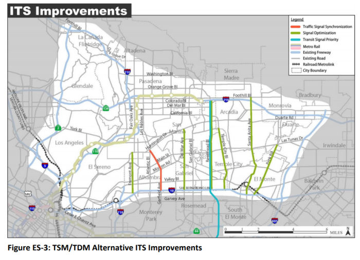 In November 2018, it was reported that the Final EIR for the northern portion of Route 710 was signed. The historic final EIR essentially ends the six-decade conflict. The signed
and adopted EIR formally adopts a local street improvement alternative to
the multibillion dollar 8-lane tunnel proposed in 2003 to replace the
originally proposed surface freeway route. The initial freeway proposal
triggered debate on this issue going back to the Eisenhower
administration. In addition to presenting the EIR, Senator Portantino
unveiled his plan to introduce legislation to formally remove the tunnel
from the streets and highways code and to help facilitate the sale of
Caltrans owned properties currently in the hands of non-profits. The Final
EIR considered five alternatives: No Build, Transportation System
Management/Transportation Demand Management (TSM/TDM), Bus Rapid Transit
(BRT), Light Rail Transit (LRT), and a Freeway Tunnel. The final adopted
alternative was the TSM/TDM. Details on the others can be found in the
FEIR (and likely, the discussion above). The Transportation System
Management/Transportation Demand Management (TSM/TDM) Alternative consists
of strategies and improvements to increase efficiency and capacity for all
modes in the transportation system with lower capital cost investments
and/or lower potential impacts. The TSM/TDM Alternative is designed to
maximize the efficiency of the existing transportation system by improving
capacity and reducing the effects of bottlenecks and chokepoints. TSM
strategies in the TSM/TDM Alternative are: (◆) Intelligent
Transportation System (ITS) Improvements, including traffic signal
upgrades, synchronization and transit prioritization, arterial changeable
message signs (CMS), and arterial video and speed data collection systems;
(◆) Local Street and Intersection Improvements; and Active Traffic
Management (ATM), including arterial speed data collection and CMS. TDM
(Transportation Demand Management) strategies focus on regional means of
reducing the number of vehicle trips and vehicle miles traveled as well as
increasing vehicle occupancy. The TDM strategies included in the TSM/TDM
Alternative are: Expanded Bus Service and Bus Service Improvements and
Active Transportation Improvements (which consist mostly of Class III bike
routes). The construction of the TSM/TDM Alternative is estimated to cost
approximately $105 million (in 2014 dollars) and $126 million (in 2020
dollars), which includes structures, utilities, and right of way costs.
Construction of the improvements in the TSM/TDM Alternative is expected to
take approximately 2 years.
In November 2018, it was reported that the Final EIR for the northern portion of Route 710 was signed. The historic final EIR essentially ends the six-decade conflict. The signed
and adopted EIR formally adopts a local street improvement alternative to
the multibillion dollar 8-lane tunnel proposed in 2003 to replace the
originally proposed surface freeway route. The initial freeway proposal
triggered debate on this issue going back to the Eisenhower
administration. In addition to presenting the EIR, Senator Portantino
unveiled his plan to introduce legislation to formally remove the tunnel
from the streets and highways code and to help facilitate the sale of
Caltrans owned properties currently in the hands of non-profits. The Final
EIR considered five alternatives: No Build, Transportation System
Management/Transportation Demand Management (TSM/TDM), Bus Rapid Transit
(BRT), Light Rail Transit (LRT), and a Freeway Tunnel. The final adopted
alternative was the TSM/TDM. Details on the others can be found in the
FEIR (and likely, the discussion above). The Transportation System
Management/Transportation Demand Management (TSM/TDM) Alternative consists
of strategies and improvements to increase efficiency and capacity for all
modes in the transportation system with lower capital cost investments
and/or lower potential impacts. The TSM/TDM Alternative is designed to
maximize the efficiency of the existing transportation system by improving
capacity and reducing the effects of bottlenecks and chokepoints. TSM
strategies in the TSM/TDM Alternative are: (◆) Intelligent
Transportation System (ITS) Improvements, including traffic signal
upgrades, synchronization and transit prioritization, arterial changeable
message signs (CMS), and arterial video and speed data collection systems;
(◆) Local Street and Intersection Improvements; and Active Traffic
Management (ATM), including arterial speed data collection and CMS. TDM
(Transportation Demand Management) strategies focus on regional means of
reducing the number of vehicle trips and vehicle miles traveled as well as
increasing vehicle occupancy. The TDM strategies included in the TSM/TDM
Alternative are: Expanded Bus Service and Bus Service Improvements and
Active Transportation Improvements (which consist mostly of Class III bike
routes). The construction of the TSM/TDM Alternative is estimated to cost
approximately $105 million (in 2014 dollars) and $126 million (in 2020
dollars), which includes structures, utilities, and right of way costs.
Construction of the improvements in the TSM/TDM Alternative is expected to
take approximately 2 years.
(Source: Pasadena Now, 11/28/2018; Rte710
North Final EIR)
The proposal includes numerous local and street improvements, detailed in a 6-page table in the FEIR. The map shows the projects:
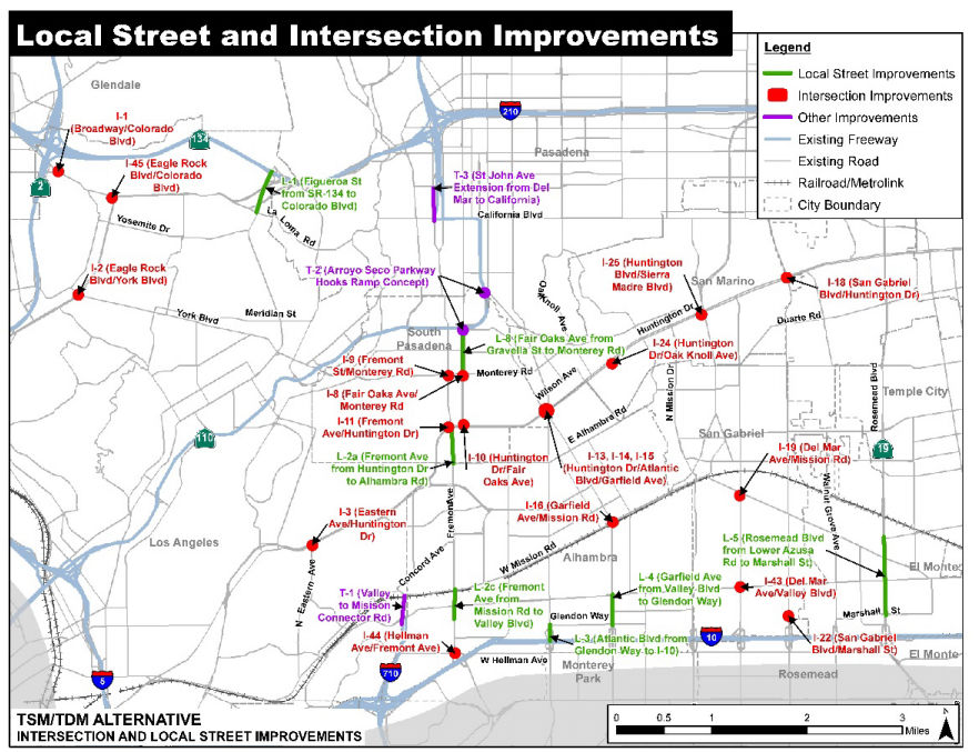
The following projects relate specific to the state highway system:
There is also a group agitating to "fill the ditch". The state-owned
ditch between California Boulevard and I-210 represents nearly 2.5 million
square feet of potential development next to the thriving Old Pasadena
downtown district. Estimates suggest the land’s development could
generate tens of millions of dollars in economic benefits. The citizen-led
Connecting Pasadena Project proposes replacing the stub with a surface boulevard and neighborhoods that scale in density from south to north. A linear park
could run parallel to the boulevard, stretching the entire length. The
city could turn St. John and Pasadena avenues into two-way streets and add
more east-west connections through the area. A partnership with Metro
could allow a transportation hub on the north end that could be used for
future light rail, or rapid bus, expansions. Councilmembers also suggested
utilizing land for much-needed affordable housing, particularly in light
of the homes lost when Caltrans took over the property decades ago. All of
the work depends on the state relinquishing the land back to Pasadena. If
California removes the northern stub from the freeway system, it will
revert to local control, where city officials, through a master plan,
could sell off parcels for development. Pasadena is now looking for grants
and other funding sources to move forward with the planning process.
(Source: Pasadena Star News, 11/1/2018; Connecting Pasadena)
In December 2018, it was reported that LA Metro approved a list of 34
projects in lieu of the completion of Route 710. These include removal of
the southern Route 710 stub at Valley Boulevard in Alhambra, construction
of a train overpass at California Boulevard in Pasadena, and three parking
structures in Monterey Park. Overall, the LA Metro board voted 8-0 to
spend more than half a billion dollars in projects. Most of the funding
comes from the $780 million set aside in Measure R, a half-cent sales tax
adopted by Los Angeles County voters in 2008 earmarked for the 4.3-mile
710 Freeway gap closure tunnel. A second round of projects coming in about
six months will give more consideration to bike lanes, electric buses and
more pedestrian walkways. The following are some of the more significant
projects:
(Source: San Gabriel Valley Tribune, 12/7/2018)
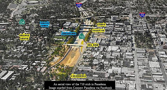 Also in December 2018, it was noted that it will likely be a long time before a
shovel is turned on any of the above projects. After the December vote,
there will be months of discussion, planning, study, and environmental
review, according to Metro and Pasadena officials. The Metro Board of
Directors has requested a meeting between all prospective project sponsors
in January to share the evaluation and selection process and to ensure
neighboring local jurisdictions are not adversely impacted by projects
proposed by individual cities. No funds can be expended on the projects
prior to the completion of the Route 710 North environmental process.
Recent Board action authorized the programming of funds for the initial
list of projects to start next fiscal year, July 1, 2019, pending no legal
challenges to the Route 710 North Project and the availability of funds
each future fiscal year. The first step on most projects will be
establishing a memorandum of understanding between the cities and Metro.
The MOU will set out the process and identify the financial terms that
Metro will impose. Project agreement typically take 6 to 12 months. The
City Council has to take a formal action to approve the MOU, and then
Metro signs and the project can start. For many, the next step will be an
environmental review process. The project will need extensive feasibility
and design studies, and there may be the need for property acquisition. If
digging is involved, plans need to be made for utility relocation. This is
all before a single shovel of dirt moves.
Also in December 2018, it was noted that it will likely be a long time before a
shovel is turned on any of the above projects. After the December vote,
there will be months of discussion, planning, study, and environmental
review, according to Metro and Pasadena officials. The Metro Board of
Directors has requested a meeting between all prospective project sponsors
in January to share the evaluation and selection process and to ensure
neighboring local jurisdictions are not adversely impacted by projects
proposed by individual cities. No funds can be expended on the projects
prior to the completion of the Route 710 North environmental process.
Recent Board action authorized the programming of funds for the initial
list of projects to start next fiscal year, July 1, 2019, pending no legal
challenges to the Route 710 North Project and the availability of funds
each future fiscal year. The first step on most projects will be
establishing a memorandum of understanding between the cities and Metro.
The MOU will set out the process and identify the financial terms that
Metro will impose. Project agreement typically take 6 to 12 months. The
City Council has to take a formal action to approve the MOU, and then
Metro signs and the project can start. For many, the next step will be an
environmental review process. The project will need extensive feasibility
and design studies, and there may be the need for property acquisition. If
digging is involved, plans need to be made for utility relocation. This is
all before a single shovel of dirt moves.
(Source: Pasadena Now, 12/17/2018)
In February 2019, it was reported that Alhambra Mayor Jeff
Maloney’s public forum on the I-710 Freeway stub and possibly
turning the land into a regional park brought strong comments from the
nearly 75 people in attendance, most of them firmly opposed to closing
that unfinished artery over concerns that such a move would increase
traffic on Alhambra streets and pose public safety issues. Those opposed
to closing that stretch of Route 710 were often longtime residents of the
city and said that closing the stub would increase traffic in the
surrounding neighborhoods, especially on Fremont Avenue and on Atlantic
and Garfield. Some pointed out that the north/south on and off-ramps on
I-10 are insufficient to handle the increase in traffic from the closing
of the stub. Other residents, who generally skewed younger, expressed
their enthusiasm for a park, saying that the entire area didn’t
necessarily have to be turned into park space and that increasing green
space while alleviating traffic was not a zero-sum proposition.
(Source: Alhambra Source, 2/22/2019)
In March 2019, it was reported that both the Alhambra and Pasadena City
Councils were concerns with the disposition of the Route 710 stubs.
Pasadena’s biggest concern is for the state transportation agency to
sell off the prime real estate adjacent to Old Pasadena and some of the
city’s most expensive neighborhoods to the highest bidder. Such an
auction would leave the city with little control except to apply de facto
zoning regulations, according to a city report from its Department of
Transportation. Pasadena has hired Point C, a consulting firm with
expertise navigating the complex rules of Caltrans, particularly when
involving excess freeway right of way. Pasadena is paying the local firm
$167,500 to advise the city how to move forward. Point C worked on the
Gold Line and other complicated transit projects. Currently, it is leading
development of an aerial tramway that would connect Union Station to
Dodger Stadium. Alhambra had previously envisioned establishing a regional
park where the stub currently sits, assuming the land was given to the
city. Most Alhambra residents who spoke at a recent council meeting were
not in favor of the park idea and instead asked the city to advocate
against the closure of the Route 710 stub, arguing that any such closure
would create an even worse traffic situation than the existing one, with
cars filling Valley Boulevard while waiting to turn north onto Fremont
Avenue toward South Pasadena and Pasadena. City Councilman Jeff Maloney
said it was clear that addressing traffic and handing over local control
of the land should be the city’s primary focus in entering into
discussions with Portantino and Holden, a position that was unanimously
supported by the rest of the council. The council also unanimously agreed
to wait for traffic studies surrounding the stub to be completed before
supporting any proposals for the land’s use and to create a
two-member City Council subcommittee to join city staff in discussions
regarding the legislation.
(Source: Pasadena Star News, 3/13/2019)
In late March 2019, it was reported that Assemblymember Chris
Holden’s legislation to remove the 710 North Project Area between
I-210 and I-10 from the California State Freeway and Expressway code, Assembly Bill 29, passed the Assembly Transportation Committee today on a
unanimous vote. The legislation aims to quell lingering concerns about
Caltrans’ Final Environmental Impact Report and a 2017 Los Angeles
Metro motion to move away from the tunnel concept for largely financial
reasons. The reasoning for both decisions may leave the tunnel solution
open to future consideration. Holden’s legislation specifies that
Route 710 is from Route 1 to Route 10, essentially eliminating any future
possibility of freeway tunnel.
(Source: Pasadena Now, 3/25/2019)
Lastly, in late March 2019, it was reported that three long-time tenants
of homes within the path of the now-defunct, 6.2-mile 710 Freeway
extension fought Caltrans in court and won. After decades of waiting,
Angeles Flores, Marysia Wojick and Priscela Izuierdo received an offer
from Caltrans in 2018 to buy the homes they’ve been renting for a
price that was hundreds of thousands of dollars less than any home on the
market in tony South Pasadena, yet at a price that took into account
inflation. They objected to the markup and sued, saying as low-income
residents who qualify for the affordable price program to buy some of the
460 homes along the 4.5-mile path of the killed extension, the homes
should sell for what Caltrans paid originally. Superior Court Judge
Mitchell Beckloff agreed with the three women. The homes should be offered
to them at the original acquisition price — no more, no less.
Beckloff ruled that Caltrans came up with the idea of upping the sales
price — sometimes six or seven times the acquisition price —
on its own. In other words, officials made it up. “Caltrans cannot
use its pricing methodology,” Beckloff wrote, saying the bureaucracy
was acting in a “type of ‘quasi-legislating’ power
…” The ramifications may make for the lowest priced,
single-family home sales in Southern California. While Caltrans has until
May 17 to appeal, the agency does not usually do so when it loses in
court, said Chris Sutton, the Pasadena attorney who represented the
tenants in the case and has been fighting for sale of the surplus homes
for decades. The ruling may allow more than 100 other tenants in the
program to buy the homes they are living in at very, very low prices. Or,
Caltrans may argue the ruling is limited to these three only.
(Source: Pasadena Star News, 3/31/2019)
In April 2019, it was reported that state Sen. Anthony Portantino (D-La
Cañada) is waiting for Caltrans to provide language for his bill, SB
7, that he introduced in January in order to get it passed in the
legislature and signed by Gov. Gavin Newsom. The goal of the bill is to
get the two stubs of the unfinished I-710 freeway out of the state highway
system and give them to the cities affected by spillover traffic. However,
the wording is up to Caltrans, since they have control over the stub and
turning it over to another jurisdiction is a delicate process. “The
biggest challenge is within government code, how you refer to liquidations
or reversal, whatever word you use, relinquishment versus abandonment
versus returning,” Portantino said. “Each word has its own
legal consequence, so Caltrans is trying to figure out what’s legal,
what’s doable, what has the best economic implications for all
sides. That’s what I’m waiting for.” Receiving this
language is the next step in the saga of what may happen to the I-710
freeway, which has stopped abruptly at Valley Boulevard in Alhambra since
the 1960s. Portantino said that unknown legal and economic implications
aside, he believes Caltrans’ priority is to facilitate local control
over the I-710 stubs in Alhambra and in Pasadena. He said that the agency
wants “to get out of the 710 business.” The bill also permits
some community nonprofits to be able to buy their respective properties at
their current use value, not market rates calculating to what the property
could converted at its highest use.
(Source: Alhambra Source, 4/1/2019; PasadenaStar
News 4/9/2019)
Also in April 2019, it was reported that three cities ready to receive a
portion of almost $1 billion in lieu of a north I-710 extension are
unhappy with the process, want more cooperation from Metro and are
concerned their suggestions are being ignored. A letter signed by the city
managers of Alhambra, Pasadena and South Pasadena to the Los Angels County
Metropolitan Transportation Authority board accuses its staff of only
accepting projects that enhance the movement of automobiles, namely adding
lanes to regional thoroughfares in an area between El Sereno and Pasadena,
from Valley Boulevard to I-210 just west of Fremont and Pasadena avenues.
“The fact sheet indicates that projects will only be deemed eligible
if they enhance vehicular capacity. There is no consideration for active
transportation or safety components, which seems contrary to the Metro
Board Motion,” the letter states. Seven cities plus Los Angeles
County are once again competing for 710 North Mobility Project dollars as
part of Phase II. The board is expected to decide on the project list in
June. Board members made promises last year to include mass transit and
active transportation (biking, walking) in the second round. Metro
rejected about $400 million mass transit and active transportation
projects submitted in Phase I. These include a bus rapid transit plan and
improved bus service on Valley Boulevard.
(Source: Pasadena Star News $$, 4/28/2019)
In July 2019, it was reported that reports of the dealth of the Alhambra
710 Stub, and its transformation into a regional park, were premature.
Neighbors say without the roadway extensions already provided, traffic
would be redirected into their cities, making congestion worse. After
plans by Caltrans to close the 4.1-mile “710 Freeway Gap”
between El Sereno, South Pasadena and Pasadena by surface or tunnel were
killed in November, cities were awarded $515 million by the Los Angeles
County Metropolitan Transportation Authority for local roadway projects,
money leftover from Measure R, a 2008 county sales tax ballot measure. Of
that, $100 million is earmarked for Alhambra to pursue a project on the
southern stub. The city announced it would study various proposals,
including parkland. State Sen. Susan Rubio, D-Baldwin Park, stands opposed
to conversion of the stubs. She said closures to the Alhambra and Pasadena
stubs would be premature and blocks input from Monterey Park, Alhambra,
Rosemead, San Marino and the city of Los Angeles. Rubio convinced
Assemblyman Chris Holden, D-Pasadena, to omit a portion of his 710 stubs
bill, AB 29, that would’ve required the California Transportation
Commission to relinquish both stubs to their respective cities. AB 29 in
its more limited form would remove the Route 710 Freeway north extension
between the I-10 and I-210 freeways from the state’s freeway system.
Rubio supports Senate Bill 7 by state Sen. Anthony Portantino, D-La
Cañada Flintridge, which codifies into law the end to a 710 tunnel
option or any completion of the 710 extension as an expressway.
(Source: Pasadena Star News, 7/22/2019)
In September 2019, it was reported that the legislature had approved both
710 related bills (they both eventually were chaptered). Senate Bill 7,
introduced by Portantino, a former La Cañada Flintridge mayor and
council member, also effectively kills the Route 710 North freeway tunnel
as a replacement for an overland connector by removing the planned
extension between Route 710 and I-210 — something that’s been
on the books since the 1940s — from the state highway code as of
Jan. 1, 2024. SB 7 also includes housing provisions such as a rent hike
freeze and an extended deadline for Caltrans tenants in its Affordable
Rent Program. A second bill, Assembly Bill 29, introduced by Democrat
Assembly member Chris Holden, a former Pasadena mayor and council member,
contains language identical to SB 7 regarding the tunnel, minus the
additional housing provisions. If Newsom decides not to support the
housing provisions in SB 7, signing AB 29 will still effectively kill the
tunnel plan. He has until Oct. 13 to sign the bills. Whichever bill he
signs last becomes law (he signed SB 7 last). Caltrans successfully
negotiated the removal of language from the SB 7 that would have compelled
the state agency to immediately relinquish control of the freeway
“stubs” — areas where the existing freeways end —
to the cities of Pasadena and Alhambra. SB7 also includes a section
allowing Caltrans, prior to 2024, to relinquish to the City of Pasadena
the portion of I-710 within its city limits—namely, the so-called
stub lands–once the city and state agree on a deal. Alhambra had
also considered its options for use of its stub if it were given control
over it. One idea the city had considered was building a regional park
there, and instead of spilling onto Valley Boulevard, cars would be forced
to go east or west onto I-10. However, with Alhambra further behind it in
its planning for the stub, Alhambra did not ask Caltrans to relinquish the
stub to the city, City Manager Jessica Binnquist said. This is why SB 7
authorizes the California Transportation Commission to relinquish only the
north stub area near California Boulevard to the city of Pasadena
“upon terms and conditions the commission finds to be in the best
interests of the state, if the department and the city enter into an
agreement providing for that relinquishment,” the bill states.
“The city of Pasadena shall ensure the continuity of traffic flow on
the relinquished portion of Route 710.” SB 7 also makes permanent a
rent hike freeze for tenants who reside in Caltrans properties in the 710
Corridor and are in the Affordable Rent Program. It also gets rid of the
so-called “2012 policy,” an arbitrary rule Caltrans used to
prevent tenants who moved in after August 2012 from being eligible for the
Affordable Rent Program. The new eligibility deadline is July 1, 2019. The
bill also helps the nonprofit tenants in the 710 Corridor purchase their
properties in a fiscally prudent manner,” including Arlington
Garden, Ronald McDonald House, Sequoyah School and others. In late 2016,
Caltrans announced it would sell the 710 properties in three phases, but
so far has only sold a handful. Caltrans has not released a timeline for
when the hundreds of remaining properties will be sold. More than 160
houses — including about 50 percent of the houses that Caltrans owns
in Pasadena — are vacant and falling into disrepair, according to an
investigation by the Pasadena Star-News. Caltrans does not rent out houses
again after they become vacant. In October 2019, it was reported that the
Governor signed both bills, but signed SB 7 last -- putting the housing
provisions into law, and in 2024, relinquishing the portion between
Alhambra Ave (not I-10, as in AB 29) and I-210.
(Source: Pasadena Weekly, 9/19/2019; PasadenaNow,
10/13/2019; South Pasadenan, 10/15/2019, PasadenaStar
News, 10/14/2019)
In September 2019, it was reported that the Los Angeles County
Metropolitan Transit Authority (Metro) board approved funding for
$136,850,000-worth of traffic improvements in Pasadena. The appropriation
was part of an overall $297 million appropriated for San Gabriel
Valley-area transportation initiatives. The funds were tied up in the 710
freeway extension project. Its demise resulted in their reallocation to
mobility improvement projects aimed at resolving the same traffic problems
the original project was proposed to fix. Most of the projects funded by
Metro were on Pasadena’s Route 710 North Early Action Project
“wish list” sent by the Council to Metro in January 2018. The
biggest recipient was the Gold Line grade separation project at California
Boulevard. Metro set aside $125 million for right-of-way and construction.
A project to modify intersections at the California Boulevard Route 710
Freeway offramps and the Pasadena Avenue northbound onramp got $2.6
million. That project could result in the closure of the Route 710 Freeway
southbound offramp that currently empties onto South Saint John Avenue and
California Boulevard. $850,000 was reallocated for an upgrading of the
traffic signal at Fair Oaks Avenue and Bellevue Drive. The Walnut Street
Corridor Signal Improvement Project was the recipient of another $4.1
million. Lastly, a project upgrading flow throughout Pasadena with new
traffic signal controllers and cabinets, fiber-optics communication, and
signal preemption technology, is slated to receive a $3.8 million boost.
(Source: Pasadena Now, 9/30/2019)
In October 2019, Governor Newsom signed AB 29 (Chapter 791, Statutes of 2019, 10/21/2019) and SB 7 (Chapter 835, Statutes of 2019, 10/21/2019). As SB 7 was chaptered later, it is the bill with precedence. SB 7 requires, according to the executive summary:
(1) Existing law establishes priorities and procedures that any state agency disposing of surplus residential property is required to follow. Under existing law, specified single-family residences must first be offered to their former owners or present occupants, as specified. Existing law also gives tenants in good standing of nonresidential properties priority to purchase, at fair market value, the property they rent, lease, or otherwise legally occupy.
This bill would require a state agency to give priority to a tenant in good standing of a nonresidential property to purchase, at the lesser of fair market value or value in use, as defined, if the tenant is a city or a nonprofit organization, as specified. The bill would prohibit the Department of Transportation from selling a nonresidential property to a tenant described above at a value below the minimum sales price, as defined in the department’s Affordable Sales Program as of July 1, 2019. The bill would require the selling agency, if a nonresidential property is offered at a price that is less than fair market value, to impose appropriate terms, conditions, and restrictions.
(2) Existing law provides, notwithstanding any other law, for purposes of the California Environmental Quality Act, that the preliminary project alternative referred to as Alternative F-6 in the December 2012 Alternative Analysis Report of the Los Angeles County Metropolitan Transportation Authority is no longer deemed to be a feasible alternative for consideration in any state environmental review process for the Interstate 710 North Gap Closure project.
This bill would revise this provision to instead provide that the preliminary project alternatives referred to as Alternative F-5, F-6, and F-7 in the December 2012 Alternative Analysis Report of the Los Angeles County Metropolitan Transportation Authority and any other freeway or tunnel alternatives to close the Interstate 710 North Gap are no longer deemed to be feasible alternatives for consideration in any environmental review process for the Interstate 710 North Gap Closure project.
(3) Existing law prohibits the Department of Transportation, until January 1, 2020, from increasing the rent of tenants who reside in surplus residential property located within the State Route 710 corridor in the County of Los Angeles and who participate in the Affordable Rent Program administered by the department.
This bill would make this prohibition permanent and would also provide that signatories of active rental agreements for residential property entered into with the department as of July 1, 2019, and continuously residing at the property since that date, may be eligible to participate in the department’s Affordable Rent Program.
(4) Existing law vests the Department of Transportation with full possession and control of all state highways and associated property. Existing law designates and describes state highway routes, and also describes the state highway routes in the California freeway and expressway system, including all of State Highway Route 710 in the County of Los Angeles.
This bill would, on January 1, 2024, remove from the California freeway and expressway system the portion of Route 710 between Alhambra Avenue in the City of Los Angeles and California Boulevard in the City of Pasadena.
(5) Existing law establishes a process for the California Transportation Commission to adopt a highway on an authorized route, requires the commission to relinquish to local agencies state highway portions that have been deleted from the state highway system by legislative enactment, and authorizes relinquishment in certain other cases.
This bill would authorize the commission to relinquish to the City of Pasadena the specified portions of Route 710 within its city limits, upon terms and conditions the commission finds to be in the best interests of the state, if the department and the city enter into an agreement providing for that relinquishment.
Provisions (1) and (3) impact housing in the Route 710 corridor. Provision (2) eliminates any possibility of constructing the gap closure without going through the environmental process all over again (which will never happen), as it declares any freeway completion options as non-feasible. Provisions (4) and (5) affect the definition of the route in the freeway and expressway system (Article 2) and the state route definitions (Article 3): (4) removes the unconstructed portion from the freeway and expressway system, and (5) authorizes relinquishment of the Pasadena stub.
In June/July 2020, a (virtual) presentation was made regarding the
Alhambra stubs. The selected alternatives appear to be as follows; the
next steps are to get Metro buy-in:
(Source: GTC Presentation to Alhambra City Council, "710 NORTH ANALYSIS UPDATE", June 8, 2020, via fungus on AARoads)
In April 2021, it was reported that the death of the Route 710 extension
has freed up more than $700 million for other transportation projects in
the Eastside and in the San Gabriel Valley. In May 2021, the Bureau of
Engineering and the office of Councilmember Kevin de Leon were holding
public meetings for potential changes to Valley Boulevard and Mission Road
between the I-710 freeway terminus and Union Station. The two
corridors, which span approximately four miles, each are four-lane streets
running east-to-west parallel with I-10. The City is considering a suite
of projects that could include Vision Zero safety features at street
crossings and rail crossings; a potential bus rapid transit line; new
electrification infrastructure; and improved access for pedestrians and
cyclists. In addition to Valley Boulevard and Mission Road, the City of
Los Angeles is also expected to redirect money from the scuttled 710
extension toward new projects on Eastern Avenue and Huntington Drive.
(Source: Urbanize LA, 4/21/2021)
In July 2021, Governor Newsom signed SB 51 (Chapter 130, 7/23/2021). This bill specifically relates to sale of property located within the Route 710 corridor in the City of Los Angeles to a housing-related entity will promote the preservation and creation of affordable housing consistent with Section 54235 of the Government Code. The key elements are as follows, from the bill summary:
(2) Existing law establishes priorities and procedures that any state agency disposing of surplus residential property is required to follow. Under existing law, specified single-family residences must first be offered to their former owners or present occupants, as specified. Existing law then requires the property to be offered to housing-related entities, as provided, prior to placing the property up for sale, subject to specified priorities. Existing law requires, if a property that is not a historic home is sold to a private housing-related entity or a housing-related public entity, that the entity develop the property as limited equity cooperative housing with first right of occupancy to present occupants, or use the property for low- and moderate-income rental or owner-occupied housing where the development of cooperative or cooperatives is not feasible. Existing law requires, if a property is a historic home, as defined, that the property be offered first to a housing-related entity, subject to the above-described requirements, or a nonprofit private entity dedicated to rehabilitating and maintaining the historic home for public and community access and use, as provided.
This bill would, with respect to surplus residential property that is located within the City of Los Angeles, instead require that if the surplus residential property is not sold to a former owner or present occupant, as described above, the property be offered at fair market value to present tenants who have occupied the property for 5 years or more and who are in good standing with all rent obligations current and paid in full, with first right of occupancy to the present occupants. If the surplus residential property is a historic home, as defined, the bill would then require that the property be offered to the city in which the property is located or a nonprofit private entity dedicated to rehabilitating and maintaining the historic home for public and community access and use, subject to specified terms and conditions. Finally, the bill would require that surplus residential property be offered to a housing-related entity, subject to specified terms and conditions. The bill would require a housing-related entity to cause the property to be used, under specified conditions, either for low- and moderate-income rental housing for a term of at least 55 years, subject to a recorded covenant, to ensure use as affordable housing, as provided, and to provide a first right of occupancy to the present tenants, or, if the surplus residential property is a single-family residence, the bill would provide the surplus residential property may be used for owner- occupied affordable housing for a term of at least 45 years, subject to a covenant recorded against the property to ensure its use as affordable housing. The bill would require the Department of Transportation to monitor or designate a public agency to monitor a property’s compliance with the bill’s terms, conditions, and restrictions, in the case of a historic home, and require the City of Los Angeles to monitor compliance with the recorded covenant, in the case of surplus residential properties sold to a housing-related entity, and authorize the monitoring entity to charge the property owner a fee to cover the cost of monitoring and reporting. The bill would require the city to prepare and submit to the Legislature reports that describe how the purchasers complied with these provisions and how they were monitored for compliance, as specified. By requiring additional duties by the City of Los Angeles, this bill would impose a state-mandated local program.
This bill would prohibit surplus residential property from being sold at less than the price paid by the Department of Transportation for original acquisition of the property. The bill would prohibit the adjustment of this original acquisition price for inflation. The bill would require the Department of Transportation to offer to sell specified unimproved properties at the original acquisition price paid by the department to a housing-related entity for affordable housing purposes, as provided.
In September 2021, it was reported that Pasadena was moving closer to
regaining control of the Route 710 stub near I-210. City staff plans to
return to the council in December with a recommendation to submit reports
to the California Transportation Commission (CTC) for relinquishment
approval of the stub. The city has already completed a technical
feasibility assessment and has now moved into the next phase which
includes a supplemental traffic analysis and the development of a
relinquishment agreement between the city and Caltrans. There are elements
of racial justice in the process, as Caltrans also demolished dozens of
African-American homes in western Pasadena for the project. President
Biden’s $3.5 trillion infrastructure plan supposedly will address
racism ingrained in historical transportation and urban planning by
earmarking $20 billion for a program that would “reconnect
neighborhoods cut off by historic investments,” according to the
Biden administration. Once the city gets the land back, a
multidisciplinary community-driven process will begin to lay out the
future land use, transportation and utility infrastructure networks needed
to reconnect Pasadena. That effort will include significant public
outreach and input to rework the stub back into the city. This multi-year
effort is expected to begin sometime in 2022. Per SB 7 (Chapter 835,
10/21/2019), the CTC may now make a determination to relinquish the stub
to Pasadena if Caltrans and the city enter into an agreement providing for
that relinquishment.
(Source: Pasadena Now, 9/15/2021)
In September 2021, Governor Newsom signed SB 381, which impacted the sale
of property in the 710 corridor. The Executive Summary notes:
(Source: SB 381, Chapter 362, Statutes of 2021,
09/28/21)
This bill would, with respect to surplus residential properties located within the State Route 710 corridor in the City of South Pasadena, require surplus single-family residential properties, which includes any applicable locally-designated historic home as defined, and any historic home to be offered to the City of South Pasadena after the properties are offered to present occupants, including present occupants who have occupied the property for 5 years or more and meet certain conditions, pursuant to specified provisions and the present occupants either decline to purchase or do not qualify and close on the property within 274 days of the Department of Transportation adopting emergency regulations. The bill would require a multifamily residential property in the State Route 710 corridor area of the city to first be offered to certain present occupants who have formed a limited equity cooperative housing entity or an entity for the ownership of common interest developments before offering those properties to the city. The bill would also require all other occupied, unoccupied, and unimproved surplus residential properties in the State Route 710 corridor area of the city to first be offered to the city. The bill would set forth procedures that apply to properties under the bill’s provisions, including that each property be subject to a recorded covenant requiring the property remain available and affordable for ownership or rental by persons and families of low or moderate income, except as specified. The bill would require all proceeds from the city’s sale of any property purchased pursuant to the bill’s provisions to be reinvested into low- or moderate-income housing within its jurisdiction. The bill would require, following an offer of these properties to the City of South Pasadena, the properties to then be offered in accordance with the priorities and procedures in existing law relating to the sale of the property to a private housing-related entity or housing-related public entity and sale for fair market value.
This bill would require the Department of Transportation to adopt emergency regulations within 60 days of the effective date of the bill’s provisions, to implement the above-described requirements relating to the disposal of surplus property. The bill would include findings that an emergency exists for purposes of specified provisions of the Administrative Procedure Act. The bill, notwithstanding the 180-day limit for emergency regulations, would provide that emergency regulations adopted under its provisions would remain in effect for 2 years after adoption, or until the adoption of permanent regulations, whichever occurs sooner.
This bill would authorize an increase in the amount of the total funds maintained in the account up to $1,200,000. By authorizing an increase in the funds held in a continuously appropriated fund, the bill would make an appropriation.
This bill would require that a surplus residence or property located in the City of South Pasadena that is offered by a selling agency to a present occupant of the residence or property be offered at a price based on the appraisal of the residence or property in 2016 if certain conditions apply. The bill would require an offer made or accepted prior to January 1, 2022, that is not in compliance with this provision to be corrected so the price is based on the 2016 appraisal. The bill would provide that an offer made based on the 2016 appraisal shall only be effective until December 31, 2022.
In May 2022, it was reported that the Pasadena City Council voted to
approve their end of a contract with Caltrans to reclaim a portion of the
land that Caltrans had already purchased for extending Route 710
– land located between Union Street and Columbia Street. The
California Transportation Commission needs to approve the transfer, but
with Caltrans and the city in agreement, that last hurdle could well be
little more than a formality. Without this land, the 710 gap closure
project will be so dead that it can’t be resurrected.
(Source: 669xGxaLjwqejoaIaV13l5bsLPKY9BVt4CtqdV6KUPa6lUIBf-O3IU">Streetsblog LA, 5/4/2022)
In May 2022, the CTC amended the following into the SHOPP: 07-LA-710
T30.953/R32.5. PPNO 07-5964; ProjID 0722000204; EA 38710. Route 710 In
Pasadena, from Columbia Street to Union Street Financial Contribution Only
(FCO) to the City of Pasadena to relinquish roadway. Allocation ($ ×
1,000): PA&ED $150; Const Cap $5,000; TOTAL $5,150.
(Source: May 2022 CTC Agenda, Agenda Item 2.1a.(1a)
#36)
In May 2022, the CTC approved the following pre-construction phase SHOPP
allocation: $150,000. 07-LA-710 T30.953/R32.5. PPNO 07-5964; ProjID
0722000204; EA 38710. Route 710 In Pasadena, from Columbia Street to Union
Street. Financial Contribution Only (FCO) to the City of Pasadena to
relinquish roadway. (Concurrent Amendment under SHOPP Amendment 22H-001;
May 2022.) Allocation: FY21-22 PA&ED $150,000.
(Source: May 2022 CTC Agenda, Agenda Item 2.5b.(2a) #20)
In June 2022, the CTC approved the following "construction" phase SHOPP
allocation: $5,000,000. 07-LA-710 T30.953/R32.5. PPNO 07-5964; ProjID
0722000204; EA 38710. Route 710 In Pasadena, from Columbia Street to Union
Street. Financial Contribution Only (FCO) to the City of Pasadena to
relinquish roadway. (Concurrent Amendment under SHOPP Amendment 22H-001;
May 2022.) Allocation: FY21-22 CONST $5,000,000.
(Source: June 2022 CTC Agenda, Agenda Item
2.5b.(6))
In June 2022, it was reported that the final roadblock in the fight to
relinquish the 710-corridor to Pasadena has been cleared after a unanimous
vote by the California Transportation Commission officially cemented the
return of 50 acres of land at Route 710's northern terminus back to the
city of Pasadena along with a payment of $5 million. With the approval, a
deal between Pasadena and Caltrans can move ahead, enabling the city to
move on plans to rework the land — a dusty corridor of gravel and
dirt known as the “710 stub” — back into the fabric of
the community. The terms of the relinquishment agreement between Caltrans
and Pasadena for Route 710 between Columbia Street and Union Street calls
for the city to assume full maintenance, ownership, responsibility,
control and liability of the relinquished portion of Route 710. Extensive
public outreach effort will begin later in 2022. According to the
city’s timeline, construction isn’t expected to begin until
sometime between 2026 and 2030.
(Source: Pasadena Star News, 6/29/2022)
 In June 2022, the CTC authorized relinquishment of right
of way in the city of Pasadena along State Route 710 between Columbia
Street and Union Street (15 segments, 07-LA-710-PM T30.9/R32.5), under
terms and conditions as stated in the relinquishment agreement dated June
1, 2022, determined to be in the best interest of the State.
Authorized by Chapter 835, Statutes of 2019, which amended Section 622.3
of the Streets and Highways Code. The relinquishment resolution noted that
"by said Relinquishment Agreement, the City of Pasadena is willing to
accept a payment of $5,000,000 or some other allocation made by the
California Transportation Commission (CTC), determined to be in the best
interest of CALTRANS, as CALTRANS only payment obligation and even if
funds are not available with CALTRANS at the time of resolution of
relinquishment by the CTC, to accept RELINQUISHED FACILITIES immediately
upon recordation of CTC’s Resolution in the County Recorder’s
Office and defer the receipt of payment for RELINQUISHED FACILITIES to a
date when funding becomes available". The relinquishment agreement also
noted that the segments were "relinquished to the City of Pasadena for use
as city streets" and that Modified Access Report from the city "must be
approved by FHWA and Caltrans" and that the "Revised Freeway Agreement(s)
must be approved by Caltrans and the CITY before conversion of the
existing freeway-to-freeway connection to freeway to local streets
connections". The City must also notify "Caltrans and FHWA if any portion
of the relinquished area will not be used for transportation purposes;
FHWA and Caltrans will review the notification and determine the
appropriate actions to comply with federal requirements". The concern
seems to be that the stub was built by Federal funds for freeway purposes,
and so if they aren't used for transportation, there are funding concerns
involved. This is why the CTC included the following lines in the
resolution: "that in the event of Federal Highway Administration (FHWA)
exercising its rights under 23 CFR 620.203(f)(3), withholds or proposes to
withhold Federal-aid highway funds due to the State of California, as a
result of its finding that RELINQUISHED FACILITIES or portion thereof has
been abandoned or repurposed by CITY for nonpublic roadway purposes, CITY
has agreed, as per letter dated June 16, 2022, to reimburse CALTRANS an
amount equal to the funds so withheld or proposed to be withheld by FHWA".
However, a letter from FHWA dated June 27, 2022 notes "While FHWA
recognizes the benefit of having reversionary language included in the
documentation associated with this project, it is not something that we
have required in past relinquishment proposals. For the purposes of
this project, we believe the repayment agreement between Caltrans and the
City is adequate assurance for this relinquishment and memorializes the
commitment that must be in place to ensure accountability." There are
interesting implications for this, especially if the City wants to turn
any portion of the main parcel into commercial property, or even parkland
(I don't think the FHWA is concerned with the residential/city street
collateral segments). That might require reimbursement to the state.
Additionally, this relinquishment is occurring BEFORE the stub has been
closed and the transitions converted to city streets -- meaning the city
will be on the hook for the construction work to redo the stub (although
Caltrans might redo the portion on the N side of the interchange, and just
closing ramps to the stub). It is also interesting that the relinquishment
resolution DID NOT include any portions of Route 134 -- meaning the
transitions ramps are still state highway. Translation: This is still a
mess.
In June 2022, the CTC authorized relinquishment of right
of way in the city of Pasadena along State Route 710 between Columbia
Street and Union Street (15 segments, 07-LA-710-PM T30.9/R32.5), under
terms and conditions as stated in the relinquishment agreement dated June
1, 2022, determined to be in the best interest of the State.
Authorized by Chapter 835, Statutes of 2019, which amended Section 622.3
of the Streets and Highways Code. The relinquishment resolution noted that
"by said Relinquishment Agreement, the City of Pasadena is willing to
accept a payment of $5,000,000 or some other allocation made by the
California Transportation Commission (CTC), determined to be in the best
interest of CALTRANS, as CALTRANS only payment obligation and even if
funds are not available with CALTRANS at the time of resolution of
relinquishment by the CTC, to accept RELINQUISHED FACILITIES immediately
upon recordation of CTC’s Resolution in the County Recorder’s
Office and defer the receipt of payment for RELINQUISHED FACILITIES to a
date when funding becomes available". The relinquishment agreement also
noted that the segments were "relinquished to the City of Pasadena for use
as city streets" and that Modified Access Report from the city "must be
approved by FHWA and Caltrans" and that the "Revised Freeway Agreement(s)
must be approved by Caltrans and the CITY before conversion of the
existing freeway-to-freeway connection to freeway to local streets
connections". The City must also notify "Caltrans and FHWA if any portion
of the relinquished area will not be used for transportation purposes;
FHWA and Caltrans will review the notification and determine the
appropriate actions to comply with federal requirements". The concern
seems to be that the stub was built by Federal funds for freeway purposes,
and so if they aren't used for transportation, there are funding concerns
involved. This is why the CTC included the following lines in the
resolution: "that in the event of Federal Highway Administration (FHWA)
exercising its rights under 23 CFR 620.203(f)(3), withholds or proposes to
withhold Federal-aid highway funds due to the State of California, as a
result of its finding that RELINQUISHED FACILITIES or portion thereof has
been abandoned or repurposed by CITY for nonpublic roadway purposes, CITY
has agreed, as per letter dated June 16, 2022, to reimburse CALTRANS an
amount equal to the funds so withheld or proposed to be withheld by FHWA".
However, a letter from FHWA dated June 27, 2022 notes "While FHWA
recognizes the benefit of having reversionary language included in the
documentation associated with this project, it is not something that we
have required in past relinquishment proposals. For the purposes of
this project, we believe the repayment agreement between Caltrans and the
City is adequate assurance for this relinquishment and memorializes the
commitment that must be in place to ensure accountability." There are
interesting implications for this, especially if the City wants to turn
any portion of the main parcel into commercial property, or even parkland
(I don't think the FHWA is concerned with the residential/city street
collateral segments). That might require reimbursement to the state.
Additionally, this relinquishment is occurring BEFORE the stub has been
closed and the transitions converted to city streets -- meaning the city
will be on the hook for the construction work to redo the stub (although
Caltrans might redo the portion on the N side of the interchange, and just
closing ramps to the stub). It is also interesting that the relinquishment
resolution DID NOT include any portions of Route 134 -- meaning the
transitions ramps are still state highway. Translation: This is still a
mess.
(Source: June 2022 CTC Agenda, Agenda Item
2.3c.(2), including yellow and pink supplementary material)
In September 2022, SB 959 passed. This bill impacts this corridor. Existing law specified single-family residences must first be offered to their present occupants, as specified. Existing law then requires the property to be offered to housing-related entities, as provided, prior to placing the property up for sale for fair market value, subject to specified priorities. This bill, with respect to surplus residential property that is located `within the City of Pasadena, would instead require that if the surplus residential property is not sold to a present occupant, as described above, the property be offered at fair market value to present tenants who have occupied the property for 5 years or more and who are in good standing with all rent obligations current and paid in full, with first right of occupancy to the present occupants. The bill would then require that the property be offered to the City of Pasadena, subject to specified terms and conditions. Finally, the bill would require that surplus residential property be offered to a housing-related entity or nonprofit private entity, as applicable, pursuant to existing provisions before being sold at fair market value, pursuant to existing provisions. This bill would require the Department of Housing and Community Development to determine compliance with certain terms and conditions, as provided. The bill would authorize the Department of Transportation to designate in regulations to, or delegate by agreement to, a public agency to monitor certain purchasers’ compliance with certain terms, conditions, and restrictions. The bill authorizes the monitoring entity to charge the property owner a fee to recover the cost of this monitoring and reporting.
In February 2023, it was reported that the city of Pasadena will receive
$2 million for the North 710 Freeway Stub Re-envisioning Project in the
city of Pasadena, to study transportation and land use needs near this
recently relinquished highway stub. This short piece of freeway was built
in anticipation of future highway connection, caused massive residential
displacement gutting a Black neighborhood, and severed access to a central
business district. The freeway connection was later canceled. The funding
is part of the Reconnecting Communities Pilot program through the U.S.
Department of Transportation. The other cities receiving funds are
Oakland, San Jose, Long Beach, and Fresno. The pilot program was
established in the nation's Bipartisan Infrastructure Law, which passed in
2021.
(Source: Streetsblog LA, 2/28/2023)
In July 2023, it was reported that for the first time in 60 years, a
large group of vacant houses owned by the state of California within the
path of the defunct Route 710 Freeway extension will be purchased by the
city of Pasadena, then re-sold by brokers to private buyers and families
to occupy. Caltrans, the owners of about 100 properties in Pasadena
located on both sides of the Route 710 ditch, along St. John Avenue,
Pasadena Avenue, State Street and side streets since the mid 1960s, has
released 17 vacant single-family homes to the city for acquisition. By the
end of July 2023, the city will choose from several interested real estate
brokers. The staff will go to the City Council by the end of summer for
approval of the specific, vacant homes the city will buy, as well as the
brokers chosen to re-sell the properties to the public. In order to build
a 6.3-mile extension of the Route 710 Freeway, which starts at the Port of
Los Angeles and ends at the northern terminus near Alhambra at Valley
Boulevard, Caltrans bought about 450 homes in the 1960s in El Sereno,
South Pasadena and Pasadena. But the city of South Pasadena and
environmental groups stopped the freeway through lawsuits in the 1970s and
1980s. Later, the agency wanted to build the freeway extension
underground, as a long tunnel connecting to the I-210/Route 134 freeways.
But any extension was killed by LA Metro, and then by Caltrans and the
state secretary of transportation in November 2018. What was left were a
string of houses in middle-income El Sereno and pricey South Pasadena and
Pasadena. Some are occupied by tenants who pay rent to Caltrans but when
tenants died or were evicted, Caltrans often did not rent them to new
occupants.
(Source: Press-Telegram, 7/21/2023)
In October 2023, SB 710 passed (Chapter 501, 10/8/2023). This bill requires Caltrans to establish and administer a Terminus Regional Planning Task Force, as
provided, to meet quarterly and complete and submit a report to the
Legislature on the issues of traffic and potential land use related to the
Route 710 Terminus adjacent areas, as defined. The bill would repeal these
provisions on January 1, 2027.
 Commuter Lanes
 Naming
The portion of this route between Route 1 and the northern end of Harbor Scenic Drive, from Harbor Scenic Drive to Ocean Boulevard, from Ocean Boulevard west of its intersection with Harbor Scenic Drive to its junction with Seaside Boulevard, and from Seaside Boulevard from the junction with Ocean Boulevard to Route 47 is not officially named. The portion along Ocean Blvd and Seaside appears to be informally called the Seaside Freeway.
 The bicycle pedestrian path on the replacement Gerald Desmond Bridge (~ LA 4.513) on Route 710, in the County
of Los Angeles, is named the "Mark Bixby Memorial Bicycle Pedestrian
Path". It was named in memory of Mark Llewellyn Bixby, who was a
member of one of the founding families of the City of Long Beach. Bixby
was also a past president of the Long Beach Rotary Club, which was
instrumental in raising money to build Rotary Centennial Park, located on
Pacific Coast Highway (Route 1) and Junipero Avenue in the City of Long
Beach. Bixby was also the director of the BikeFest Tour of Long Beach and
was a vocal proponent of adding bicycle lanes to the replacement Gerald
Desmond Bridge. Tragically, Mark Bixby lost his life in a plane crash in
2011 at 44 years of age. Named by Assembly Concurrent Resolution 100,
Resolution Chapter 109, on September 4, 2012.
The bicycle pedestrian path on the replacement Gerald Desmond Bridge (~ LA 4.513) on Route 710, in the County
of Los Angeles, is named the "Mark Bixby Memorial Bicycle Pedestrian
Path". It was named in memory of Mark Llewellyn Bixby, who was a
member of one of the founding families of the City of Long Beach. Bixby
was also a past president of the Long Beach Rotary Club, which was
instrumental in raising money to build Rotary Centennial Park, located on
Pacific Coast Highway (Route 1) and Junipero Avenue in the City of Long
Beach. Bixby was also the director of the BikeFest Tour of Long Beach and
was a vocal proponent of adding bicycle lanes to the replacement Gerald
Desmond Bridge. Tragically, Mark Bixby lost his life in a plane crash in
2011 at 44 years of age. Named by Assembly Concurrent Resolution 100,
Resolution Chapter 109, on September 4, 2012.
(Image source: Legacy.Com Obituary)
 The portion of I-710 that runs between Pico Avenue and the Pacific Coast Highway (Route 1) in the City of Long Beach (~ LA 5.213 to LA 6.842) is named the "Senator
Jenny Oropeza Memorial Freeway". It was named in memory of Jenny
Oropeza, who passed away on October 20, 2010. Oropeza was a lifelong
public servant who was active in her community and was elected first to
the Long Beach Unified School District Board of Education, then to the
Long Beach City Council and the Assembly of the State of California, and
finally to the Senate of the State of California. During her time as a
Member of the Legislature, Jenny Oropeza was a champion for public
transportation, health care, education, clean air, equality, and the
prevention of cancer. Senator Oropeza was so admired by her constituents
and community that she was posthumously awarded the Political Leadership
Award in 2011 by the Democratic Women’s Study Club in Long Beach,
which has renamed that award the Jenny Oropeza Political Leadership Award.
The Long Beach Community Hispanic Association (Centro CHA) posthumously
awarded Senator Oropeza the Create Change Community Service Excellence
Award in 2011, which will in future years be called the Create Change:
Jenny Oropeza Community Service Excellence Award. In recognition of
Senator Oropeza, the Long Beach Lambda Democratic Club created the Jenny
Oropeza Ally of the Year Award, which was first awarded in 2011. As a
tribute to Senator Oropeza’s dedication to fostering protections for
key state public health programs, the Los Angeles County Affiliate of
Susan G. Komen for the Cure, in joint collaboration with the six other
California-based Komen affiliates, known as “the California
Collaborative,” established the Senator Jenny Oropeza Public Policy
Internship position. The City of Long Beach named the community center in
Cesar E. Chavez Park the Jenny Oropeza Community Center and the Los
Angeles Unified School District dedicated the Jenny Oropeza Global Studies
Academy at the Rancho Dominguez Preparatory School. Shortly after taking
office in 2000, then Assembly Member Oropeza became aware that the Alameda
Corridor would open in 2002 and that all the planned bridges, designed to
prevent cars from having to wait for trains to pass at street level, would
be completed, except for the bridge on the Pacific Coast Highway (Route 1)
in the community of Wilmington, which was the busiest route along the
Alameda Corridor. The bridge to be built at that location would bisect the
Equilon Refinery and was therefore the most complicated and expensive
bridge to build, and there was not enough funding to complete the bridge.
Senator Oropeza brought together the interested parties, including the
Department of Transportation, the Alameda Corridor Transportation
Authority, the Los Angeles County Metropolitan Transportation Authority
(LACMTA), the Equilon Refinery, the Union Pacific Railroad, and the City
of Los Angeles to solve this problem of completing the bridge and was able
to help facilitate $107 million in funding from a combination of sources
that included state transportation funds, state Proposition 116 bond
funds, federal demonstration funds, LACMTA funds, and railroad funds.
Named by Senate Concurrent Resolution 115, Resolution Chapter 130, on
August 28, 2014.
The portion of I-710 that runs between Pico Avenue and the Pacific Coast Highway (Route 1) in the City of Long Beach (~ LA 5.213 to LA 6.842) is named the "Senator
Jenny Oropeza Memorial Freeway". It was named in memory of Jenny
Oropeza, who passed away on October 20, 2010. Oropeza was a lifelong
public servant who was active in her community and was elected first to
the Long Beach Unified School District Board of Education, then to the
Long Beach City Council and the Assembly of the State of California, and
finally to the Senate of the State of California. During her time as a
Member of the Legislature, Jenny Oropeza was a champion for public
transportation, health care, education, clean air, equality, and the
prevention of cancer. Senator Oropeza was so admired by her constituents
and community that she was posthumously awarded the Political Leadership
Award in 2011 by the Democratic Women’s Study Club in Long Beach,
which has renamed that award the Jenny Oropeza Political Leadership Award.
The Long Beach Community Hispanic Association (Centro CHA) posthumously
awarded Senator Oropeza the Create Change Community Service Excellence
Award in 2011, which will in future years be called the Create Change:
Jenny Oropeza Community Service Excellence Award. In recognition of
Senator Oropeza, the Long Beach Lambda Democratic Club created the Jenny
Oropeza Ally of the Year Award, which was first awarded in 2011. As a
tribute to Senator Oropeza’s dedication to fostering protections for
key state public health programs, the Los Angeles County Affiliate of
Susan G. Komen for the Cure, in joint collaboration with the six other
California-based Komen affiliates, known as “the California
Collaborative,” established the Senator Jenny Oropeza Public Policy
Internship position. The City of Long Beach named the community center in
Cesar E. Chavez Park the Jenny Oropeza Community Center and the Los
Angeles Unified School District dedicated the Jenny Oropeza Global Studies
Academy at the Rancho Dominguez Preparatory School. Shortly after taking
office in 2000, then Assembly Member Oropeza became aware that the Alameda
Corridor would open in 2002 and that all the planned bridges, designed to
prevent cars from having to wait for trains to pass at street level, would
be completed, except for the bridge on the Pacific Coast Highway (Route 1)
in the community of Wilmington, which was the busiest route along the
Alameda Corridor. The bridge to be built at that location would bisect the
Equilon Refinery and was therefore the most complicated and expensive
bridge to build, and there was not enough funding to complete the bridge.
Senator Oropeza brought together the interested parties, including the
Department of Transportation, the Alameda Corridor Transportation
Authority, the Los Angeles County Metropolitan Transportation Authority
(LACMTA), the Equilon Refinery, the Union Pacific Railroad, and the City
of Los Angeles to solve this problem of completing the bridge and was able
to help facilitate $107 million in funding from a combination of sources
that included state transportation funds, state Proposition 116 bond
funds, federal demonstration funds, LACMTA funds, and railroad funds.
Named by Senate Concurrent Resolution 115, Resolution Chapter 130, on
August 28, 2014.
(Image source: Wikipedia)
Note that the indicated bridge on Route 1 is also named after her, and is signed as the "Honorable Jenny Oropeza Memorial Overcrossing".
 The portion of this route from the Pacific Coast Highway to Wardlow Road in the City of Long Beach
(~ LA 6.924 to LA 9.053) is named the "Los Angeles County Deputy
Sheriff Maria Cecilia Rosa Memorial Highway". It was named in memory
of Deputy Maria Cecilia Rosa of the Los Angeles County Sheriff's
Department, who was killed in the line of duty on March 28, 2006 at the
age of 30, in the City of Long Beach. Deputy Rosa was a resident of the
City of Long Beach and was deeply committed to education. She was due to
graduate from the California State University, Long Beach, with her
Bachelors Degree. Deputy Rosa is remembered as a young woman who strived
for perfection in life. She had a captivating smile that would brighten
even the darkest of days. She was an extremely caring individual who was
always willing to go the extra mile to cheer up a friend. In addition, she
was a woman who committed her life to her family, friends, and her career
to Los Angeles County and the safety of its residents. Named by Assembly
Concurrent Resolution (ACR) 34, Resolution Chapter 48, on 6/9/2009.
The portion of this route from the Pacific Coast Highway to Wardlow Road in the City of Long Beach
(~ LA 6.924 to LA 9.053) is named the "Los Angeles County Deputy
Sheriff Maria Cecilia Rosa Memorial Highway". It was named in memory
of Deputy Maria Cecilia Rosa of the Los Angeles County Sheriff's
Department, who was killed in the line of duty on March 28, 2006 at the
age of 30, in the City of Long Beach. Deputy Rosa was a resident of the
City of Long Beach and was deeply committed to education. She was due to
graduate from the California State University, Long Beach, with her
Bachelors Degree. Deputy Rosa is remembered as a young woman who strived
for perfection in life. She had a captivating smile that would brighten
even the darkest of days. She was an extremely caring individual who was
always willing to go the extra mile to cheer up a friend. In addition, she
was a woman who committed her life to her family, friends, and her career
to Los Angeles County and the safety of its residents. Named by Assembly
Concurrent Resolution (ACR) 34, Resolution Chapter 48, on 6/9/2009.
(Image source: 404'd Flikr Page; National Law Enforcement Officers Memorial Fund)
 The portion of this route from Route 1 to
Route 5 (~ LA 6.924 to LA 22.938) is named the "Long Beach Freeway".
It was named by the State Highway Commission on November 18, 1954. Long
Beach refers to the route's terminus in Long Beach. Long Beach was first
applied to the development (because of its beaches) in the boom year,
1887. The route was originally to be called the "Los Angeles River
Freeway".
The portion of this route from Route 1 to
Route 5 (~ LA 6.924 to LA 22.938) is named the "Long Beach Freeway".
It was named by the State Highway Commission on November 18, 1954. Long
Beach refers to the route's terminus in Long Beach. Long Beach was first
applied to the development (because of its beaches) in the boom year,
1887. The route was originally to be called the "Los Angeles River
Freeway".
(Image source: Wikimedia; Caltrans District 7 on Twitter)
 The portion of I-710 from Route 91 to Alondra Boulevard (~ LA
12.97 to LA 13.94) in the County of Los Angeles is named the "Kevin
Burrell and James MacDonald Memorial Highway" (signed as "Compton
Police Officers Kevin Burrell and James MacDonald Memorial Highway").
Kevin Michael Burrell and James Wayne MacDonald were police officers
employed by the City of Compton, who dedicated their lives to keeping its
citizens safe. Kevin Michael Burrell realized that being a police officer
meant more than just making arrests; he possessed a level of unparalleled
compassion and understanding, taking advantage of every opportunity to
help those less fortunate, and was lovingly known as the “Gentle
Giant”. James Wayne MacDonald was admired by his peers, had an
amazing personality, and, although he was only required to work two shifts
per month, chose to work two shifts per week. James Wayne MacDonald loved
being a police officer and Kevin Michael Burrell was his favorite partner
with which to ride. On February 22, 1993, Kevin Michael Burrell and James
Wayne MacDonald, ages 29 and 24, respectively, while working as patrol car
partners in the City of Compton, were fatally shot by a violent gang
member during a traffic stop at the intersection of Rosecrans Avenue and
Dwight Avenue. Named by Assembly Concurrent Resolution (ACR) 178, Res.
Chapter 161, Statutes of 2016, on September 1, 2016.
The portion of I-710 from Route 91 to Alondra Boulevard (~ LA
12.97 to LA 13.94) in the County of Los Angeles is named the "Kevin
Burrell and James MacDonald Memorial Highway" (signed as "Compton
Police Officers Kevin Burrell and James MacDonald Memorial Highway").
Kevin Michael Burrell and James Wayne MacDonald were police officers
employed by the City of Compton, who dedicated their lives to keeping its
citizens safe. Kevin Michael Burrell realized that being a police officer
meant more than just making arrests; he possessed a level of unparalleled
compassion and understanding, taking advantage of every opportunity to
help those less fortunate, and was lovingly known as the “Gentle
Giant”. James Wayne MacDonald was admired by his peers, had an
amazing personality, and, although he was only required to work two shifts
per month, chose to work two shifts per week. James Wayne MacDonald loved
being a police officer and Kevin Michael Burrell was his favorite partner
with which to ride. On February 22, 1993, Kevin Michael Burrell and James
Wayne MacDonald, ages 29 and 24, respectively, while working as patrol car
partners in the City of Compton, were fatally shot by a violent gang
member during a traffic stop at the intersection of Rosecrans Avenue and
Dwight Avenue. Named by Assembly Concurrent Resolution (ACR) 178, Res.
Chapter 161, Statutes of 2016, on September 1, 2016.
(Image source: Find a Grave; California Gang Investigators Assn (Burrell); California Gang Investigators Assn (MacDonald))
 The portion of I-710
from PM LA 19.730 to PM LA 24.466 in the County of Los Angeles is named
the “Detective Raul Vasquez Gama Memorial Highway”.
It was named in memory of Raul Vasquez Gama, who was born in July 1963, in
Santa Monica, California. Gama graduated from the Los Angeles County
Sheriff’s academy on May 1, 1987, and began his career as a deputy
with the Los Angeles Sheriff’s Department at the Pico Rivera
Sheriff’s Station. After a few years, Raul Vasquez Gama transferred
to the East Los Angeles Sheriff’s Station, where he worked a variety
of assignments, including patrol duty, crime impact team, and as a
detective in the Detective Bureau. While assigned to East Los Angeles
Sheriff’s Station, Raul Vasquez Gama became the team leader for the
City of Cudahy where, as team leader, he introduced the “Meet a
Deputy” program, a model of community policing now utilized by all
Los Angeles County Sheriff stations to improve community relations.
Detective Gama served as a member of a five man team in the Cargo Criminal
Apprehension Team (Cargo CATs), where he was partnered with long time
friend Detective Gerardo Pachuca, who served with him at the East Los
Angeles Sheriff’s Station. As a member of the Cargo CATs,
Detective Gama was awarded a Medal of Valor in 2004 for rescuing four
children and their parents after a runaway Union Pacific freight train
crashed into the family’s home. Detective Gama received more than 52
commendations in his career with the Los Angeles County Sheriff’s
Department. At 8:55 a.m. on Tuesday, May 1, 2007, Detective Gama was
working undercover monitoring a suspect near Oxnard Street and Rhodes
Avenue in North Hollywood when a vehicle crashed into his parked
surveillance van. He was rushed to Providence Saint Joseph Medical Center
in Burbank, where he later succumbed to his injuries. Named by Senate
Resolution SCR 26, Resolution Chapter 86, 07/16/21.
The portion of I-710
from PM LA 19.730 to PM LA 24.466 in the County of Los Angeles is named
the “Detective Raul Vasquez Gama Memorial Highway”.
It was named in memory of Raul Vasquez Gama, who was born in July 1963, in
Santa Monica, California. Gama graduated from the Los Angeles County
Sheriff’s academy on May 1, 1987, and began his career as a deputy
with the Los Angeles Sheriff’s Department at the Pico Rivera
Sheriff’s Station. After a few years, Raul Vasquez Gama transferred
to the East Los Angeles Sheriff’s Station, where he worked a variety
of assignments, including patrol duty, crime impact team, and as a
detective in the Detective Bureau. While assigned to East Los Angeles
Sheriff’s Station, Raul Vasquez Gama became the team leader for the
City of Cudahy where, as team leader, he introduced the “Meet a
Deputy” program, a model of community policing now utilized by all
Los Angeles County Sheriff stations to improve community relations.
Detective Gama served as a member of a five man team in the Cargo Criminal
Apprehension Team (Cargo CATs), where he was partnered with long time
friend Detective Gerardo Pachuca, who served with him at the East Los
Angeles Sheriff’s Station. As a member of the Cargo CATs,
Detective Gama was awarded a Medal of Valor in 2004 for rescuing four
children and their parents after a runaway Union Pacific freight train
crashed into the family’s home. Detective Gama received more than 52
commendations in his career with the Los Angeles County Sheriff’s
Department. At 8:55 a.m. on Tuesday, May 1, 2007, Detective Gama was
working undercover monitoring a suspect near Oxnard Street and Rhodes
Avenue in North Hollywood when a vehicle crashed into his parked
surveillance van. He was rushed to Providence Saint Joseph Medical Center
in Burbank, where he later succumbed to his injuries. Named by Senate
Resolution SCR 26, Resolution Chapter 86, 07/16/21.
(Image source: LASD FB Page)
 The portion of I-710 between Rout 60 and East Cesar E. Chavez Avenue in the County of Los Angeles (~ LA
24.713 to LA 24.954) is named the Ruben Salazar Memorial Highway.
This segment was named in memory of Ruben Salazar, who was born in Ciudad
Juarez, Chihuahua, across the Rio Grande from El Paso on March 3, 1928.
Eleven months later his parents, Luz Chavez and Salvador Salazar, a watch
repairman, moved across the river to El Paso, Texas, where Ruben was
raised. After high school he entered the United States Army, where he
served a two-year tour of duty just before the Korean conflict. Out of the
service and now an American citizen, Salazar entered the University of
Texas at El Paso (UTEP) and received his bachelor of arts in journalism in
1954. During his last two years as a student at UTEP he worked as a
reporter for the El Paso Herald Post, where he demonstrated both great
interest and skill in investigative reporting, While working as a reporter
at the El Paso Herald Post, he became deeply aware of police mistreatment
of Mexicans and wrote extensively on the brutality against
Mexican-Americans in Texas prisons. After graduation, Salazar took a job
with the Press Democrat in Santa Rosa, California. Three years later, he
left the staff of the Press Democrat for a reportorial position with the
San Francisco News. Having served his seven years of apprenticeship, in
1959 he moved south as a reporter on the city staff of the Los Angeles
Times. During his six years at the Los Angeles Times in the city room, he
persuaded his superiors to allow him to write a column, sometimes
troublesome for the Times, in which he gave voice to the problems and
concerns of eastside Chicanos. He continued to give evidence of his
ability as a reporter, writing a series of articles on the Los Angeles
Latino community in 1963, for which he received an award from the
California State Fair, the Los Angeles Press Club, and the Equal
Opportunity Foundation. In addition to his awards, the series also earned
him a well-deserved reputation for conscientious and objective reporting.
In 1965, Salazar was sent to cover the civil war in the Dominican
Republic, where he described the views of the rebels and the reaction to
the U.S. involvement. Later that year, Salazar was sent by the Times to
Vietnam as a foreign correspondent to cover the rapidly escalating
American involvement there, of special interest to the Latino community
because of the proportionately large number of Mexican-Americans in the
U.S. forces and among the casualties. He was one of two Times
correspondents in Vietnam during the period of increased U.S. involvement.
In late 1966, Ruben Salazar left Vietnam and was called back by the Times
and placed as the bureau chief in Mexico City, thus becoming the first
Mexican-American to hold such a position at a major newspaper. He covered
stories throughout Latin America including the first conference of the
Latin American Solidarity Organization in Cuba in 1967. In 1968, he
covered a student demonstration in Mexico City when Mexican soldiers
opened fire. In late 1968, Salazar returned to Los Angeles with a special
assignment to cover the Mexican-American community, in which the Chicano
movement was beginning to move into high gear. Aware of the increasing
importance and rising militancy of Mexican-Americans, in the following
year the Times took steps, involving Salazar, to focus more sharply on the
Chicano community. In early 1970, he began writing a weekly column
featured on the Friday Opinion page explaining and interpreting Chicano
life and culture to the greater Los Angeles community. In January of 1970,
Salazar decided to accept a position as news director of station KMEX-TV
and planned to leave the Times. The response of the Times was to suggest
that in his new position Salazar continue writing his weekly column. He
decided he could handle both jobs and subsequently used both forums to
articulate the many grievances that Mexican-Americans had nursed for so
long. A political moderate, he nevertheless spoke out fearlessly,
condemning racism, prejudice, and segregation. Abuses by the police became
the special target of his hard-hitting weekly essays, and he repeatedly
pointed out in his column the much higher than average Mexican-American
casualty rate in the Vietnam War. As a result of his articles, he was
under investigation by the Los Angeles Police Department and the FBI, and
pressure was put on him to tone down his language. When the National
Chicano Moratorium, a committee of Chicanos who opposed the Vietnam War,
called a march for August 29, 1970, in Los Angeles, Ruben Salazar
naturally was present at the event in his dual capacity. Approximately
20,000 members from all over the United States had gathered to decry the
Vietnam War since Chicanos had the highest number of casualties in
proportion to their population. With his crew from KMEX he covered the
march from Belvedere Park to Laguna Park. As trouble began at a nearby
liquor store, it quickly led to a confrontation between the police and
marchers, which led to rioting and looting covering 28 blocks. The
violence led to 200 arrests, 60 injured, and three deaths. As the day grew
late into the afternoon, the riot moved east on Whittier Boulevard toward
the Silver Dollar Cafe. Attempting to avoid the riot-ridden streets, Ruben
Salazar and his news crew stopped to have a drink in the Silver Dollar
Cafe. Shortly after they entered the Silver Dollar Cafe, a deputy fired a
high-velocity 10-inch tear gas projectile meant for piercing walls, into
the cafe and hit Salazar in the head. Ruben Salazar was killed instantly,
suffering a projectile wound of the temple area causing massive injury to
the brain. The subsequent 16-day coroner's inquest ruled Salazar's death a
homicide, but there was never any legal action. Salazar's tragic death was
a consequence of the contentious and often racially heated period of time.
His informed, articulate, and level-headed voice for social change
inspired many in the Latino community, and his legacy has encouraged
Latinos to enter the field of journalism. In 1971, he was posthumously
awarded a special Robert F. Kennedy Journalism Award for his columns,
which communicated the culture and alienation of Chicanos effectively and
compassionately. He received the highest Raza accolade, a corrido
describing his contributions to La Raza . Ruben Salazar's life and death
has been recognized and honored with awards, scholarships, public schools,
and community centers in his name. Most notably, after the controversy of
his death had subsided, Laguna Park was renamed Salazar Park in his honor.
In July of 1976, Salazar was honored by the California State University of
Los Angeles in the renaming of South Hall to Ruben Salazar Memorial Hall.
On the 10th anniversary of his death, his widow, Sally Salazar, was the
guest of honor at the dedication of the Ruben Salazar Library in Santa
Rosa, California. Named by Senate Concurrent Resolution (SCR) 37,
Resolution Chapter 78, on 7/12/2005.
The portion of I-710 between Rout 60 and East Cesar E. Chavez Avenue in the County of Los Angeles (~ LA
24.713 to LA 24.954) is named the Ruben Salazar Memorial Highway.
This segment was named in memory of Ruben Salazar, who was born in Ciudad
Juarez, Chihuahua, across the Rio Grande from El Paso on March 3, 1928.
Eleven months later his parents, Luz Chavez and Salvador Salazar, a watch
repairman, moved across the river to El Paso, Texas, where Ruben was
raised. After high school he entered the United States Army, where he
served a two-year tour of duty just before the Korean conflict. Out of the
service and now an American citizen, Salazar entered the University of
Texas at El Paso (UTEP) and received his bachelor of arts in journalism in
1954. During his last two years as a student at UTEP he worked as a
reporter for the El Paso Herald Post, where he demonstrated both great
interest and skill in investigative reporting, While working as a reporter
at the El Paso Herald Post, he became deeply aware of police mistreatment
of Mexicans and wrote extensively on the brutality against
Mexican-Americans in Texas prisons. After graduation, Salazar took a job
with the Press Democrat in Santa Rosa, California. Three years later, he
left the staff of the Press Democrat for a reportorial position with the
San Francisco News. Having served his seven years of apprenticeship, in
1959 he moved south as a reporter on the city staff of the Los Angeles
Times. During his six years at the Los Angeles Times in the city room, he
persuaded his superiors to allow him to write a column, sometimes
troublesome for the Times, in which he gave voice to the problems and
concerns of eastside Chicanos. He continued to give evidence of his
ability as a reporter, writing a series of articles on the Los Angeles
Latino community in 1963, for which he received an award from the
California State Fair, the Los Angeles Press Club, and the Equal
Opportunity Foundation. In addition to his awards, the series also earned
him a well-deserved reputation for conscientious and objective reporting.
In 1965, Salazar was sent to cover the civil war in the Dominican
Republic, where he described the views of the rebels and the reaction to
the U.S. involvement. Later that year, Salazar was sent by the Times to
Vietnam as a foreign correspondent to cover the rapidly escalating
American involvement there, of special interest to the Latino community
because of the proportionately large number of Mexican-Americans in the
U.S. forces and among the casualties. He was one of two Times
correspondents in Vietnam during the period of increased U.S. involvement.
In late 1966, Ruben Salazar left Vietnam and was called back by the Times
and placed as the bureau chief in Mexico City, thus becoming the first
Mexican-American to hold such a position at a major newspaper. He covered
stories throughout Latin America including the first conference of the
Latin American Solidarity Organization in Cuba in 1967. In 1968, he
covered a student demonstration in Mexico City when Mexican soldiers
opened fire. In late 1968, Salazar returned to Los Angeles with a special
assignment to cover the Mexican-American community, in which the Chicano
movement was beginning to move into high gear. Aware of the increasing
importance and rising militancy of Mexican-Americans, in the following
year the Times took steps, involving Salazar, to focus more sharply on the
Chicano community. In early 1970, he began writing a weekly column
featured on the Friday Opinion page explaining and interpreting Chicano
life and culture to the greater Los Angeles community. In January of 1970,
Salazar decided to accept a position as news director of station KMEX-TV
and planned to leave the Times. The response of the Times was to suggest
that in his new position Salazar continue writing his weekly column. He
decided he could handle both jobs and subsequently used both forums to
articulate the many grievances that Mexican-Americans had nursed for so
long. A political moderate, he nevertheless spoke out fearlessly,
condemning racism, prejudice, and segregation. Abuses by the police became
the special target of his hard-hitting weekly essays, and he repeatedly
pointed out in his column the much higher than average Mexican-American
casualty rate in the Vietnam War. As a result of his articles, he was
under investigation by the Los Angeles Police Department and the FBI, and
pressure was put on him to tone down his language. When the National
Chicano Moratorium, a committee of Chicanos who opposed the Vietnam War,
called a march for August 29, 1970, in Los Angeles, Ruben Salazar
naturally was present at the event in his dual capacity. Approximately
20,000 members from all over the United States had gathered to decry the
Vietnam War since Chicanos had the highest number of casualties in
proportion to their population. With his crew from KMEX he covered the
march from Belvedere Park to Laguna Park. As trouble began at a nearby
liquor store, it quickly led to a confrontation between the police and
marchers, which led to rioting and looting covering 28 blocks. The
violence led to 200 arrests, 60 injured, and three deaths. As the day grew
late into the afternoon, the riot moved east on Whittier Boulevard toward
the Silver Dollar Cafe. Attempting to avoid the riot-ridden streets, Ruben
Salazar and his news crew stopped to have a drink in the Silver Dollar
Cafe. Shortly after they entered the Silver Dollar Cafe, a deputy fired a
high-velocity 10-inch tear gas projectile meant for piercing walls, into
the cafe and hit Salazar in the head. Ruben Salazar was killed instantly,
suffering a projectile wound of the temple area causing massive injury to
the brain. The subsequent 16-day coroner's inquest ruled Salazar's death a
homicide, but there was never any legal action. Salazar's tragic death was
a consequence of the contentious and often racially heated period of time.
His informed, articulate, and level-headed voice for social change
inspired many in the Latino community, and his legacy has encouraged
Latinos to enter the field of journalism. In 1971, he was posthumously
awarded a special Robert F. Kennedy Journalism Award for his columns,
which communicated the culture and alienation of Chicanos effectively and
compassionately. He received the highest Raza accolade, a corrido
describing his contributions to La Raza . Ruben Salazar's life and death
has been recognized and honored with awards, scholarships, public schools,
and community centers in his name. Most notably, after the controversy of
his death had subsided, Laguna Park was renamed Salazar Park in his honor.
In July of 1976, Salazar was honored by the California State University of
Los Angeles in the renaming of South Hall to Ruben Salazar Memorial Hall.
On the 10th anniversary of his death, his widow, Sally Salazar, was the
guest of honor at the dedication of the Ruben Salazar Library in Santa
Rosa, California. Named by Senate Concurrent Resolution (SCR) 37,
Resolution Chapter 78, on 7/12/2005.
(Image source: San Diego Union Tribune; Wikiwand; Wikipedia; Press Democrat)
 Before 1954, the route was named the "Los Angeles River Freeway". The first segment opened
in 1952. The Los Angeles River was named Rio de Porciuncula by the
Portolá expedition, August 2, 1769, for it was the day of Nuestra
Señora de los Angeles de Porciúncula (Our Lady of the Angels of
Portiuncula). Portiuncula was the chapel in Assisi, Italy, cradle of the
Franciscan Order. The full name of the river was recorded by Palou,
December 10, 1773. The pueblo was founded in 1781 with the name Reina de
los Angeles, but almost invariable appeared on maps and often in documents
as Pueblo de los Angeles. Various forms of the name were used ("City of
the Angels" in 1847) until the county and city became officially Los
Angeles in 1850.
Before 1954, the route was named the "Los Angeles River Freeway". The first segment opened
in 1952. The Los Angeles River was named Rio de Porciuncula by the
Portolá expedition, August 2, 1769, for it was the day of Nuestra
Señora de los Angeles de Porciúncula (Our Lady of the Angels of
Portiuncula). Portiuncula was the chapel in Assisi, Italy, cradle of the
Franciscan Order. The full name of the river was recorded by Palou,
December 10, 1773. The pueblo was founded in 1781 with the name Reina de
los Angeles, but almost invariable appeared on maps and often in documents
as Pueblo de los Angeles. Various forms of the name were used ("City of
the Angels" in 1847) until the county and city became officially Los
Angeles in 1850.
(Image source: Caltrans District 7 on Twitter)
The portion of this route from Route 5 to Route 210 (not all constructed) is not officially named.
 Named Structures
 On Route 710, although not originally on Route 710 (~ LA
4.513), is the "Gerald Desmond Bridge". Gerald "Jerry" Desmond
(April 1915 – January 1964) was a prominent Democratic politician
and civic leader in Long Beach, California who served as a Long Beach City
Councilmember and as Long Beach City Attorney. Desmond was born in Long
Beach, California in April 1915. He was the second oldest son of Walter
Desmond (1876–1951), a religious Irish Catholic lawyer from Boston
who came to California in 1905 and opened a law office in Long Beach.
Desmond attended Long Beach City College, where, in 1932, he met his
future wife, Virginia Slater. He briefly attended California State
University, Long Beach, but soon transferred to Cal Berkeley. After
graduation, along with Virginia, he attended law school at his father's
alma mater, Harvard. In 1937 he and Virginia were married, and eventually
had five children. When World War II began in 1941, Desmond worked in the
U.S. Attorney's Office. As a result, he would not have had to go into the
service, but he was eager to join and enlisted in the U.S. Navy. He was in
the supply corps, and then he was transferred to fraud investigation. The
Navy sent him to Harvard Business School to train him to prepare for
disposing of surplus disposal after the war, but never worked in this
field. While he was investigating fraud, he traveled a lot. The Desmonds
rented a house in Long Beach and Gerald went to New York, where he was
stationed. He never went overseas. After the war, he came back to Long
Beach and opened a private law practice. Desmond became active in local
government and served on the Long Beach City Council. He was a delegate to
the 1960 Democratic National Convention in Los Angeles. Later in 1960, he
was elected City Attorney and served in that position until his death in
1964 at the age of 48. The replacement for the Gerald Desmond Bridge
opened in 2020; the new bridge was called the Gerald Desmond Bridge until
its renaming in 2022.
On Route 710, although not originally on Route 710 (~ LA
4.513), is the "Gerald Desmond Bridge". Gerald "Jerry" Desmond
(April 1915 – January 1964) was a prominent Democratic politician
and civic leader in Long Beach, California who served as a Long Beach City
Councilmember and as Long Beach City Attorney. Desmond was born in Long
Beach, California in April 1915. He was the second oldest son of Walter
Desmond (1876–1951), a religious Irish Catholic lawyer from Boston
who came to California in 1905 and opened a law office in Long Beach.
Desmond attended Long Beach City College, where, in 1932, he met his
future wife, Virginia Slater. He briefly attended California State
University, Long Beach, but soon transferred to Cal Berkeley. After
graduation, along with Virginia, he attended law school at his father's
alma mater, Harvard. In 1937 he and Virginia were married, and eventually
had five children. When World War II began in 1941, Desmond worked in the
U.S. Attorney's Office. As a result, he would not have had to go into the
service, but he was eager to join and enlisted in the U.S. Navy. He was in
the supply corps, and then he was transferred to fraud investigation. The
Navy sent him to Harvard Business School to train him to prepare for
disposing of surplus disposal after the war, but never worked in this
field. While he was investigating fraud, he traveled a lot. The Desmonds
rented a house in Long Beach and Gerald went to New York, where he was
stationed. He never went overseas. After the war, he came back to Long
Beach and opened a private law practice. Desmond became active in local
government and served on the Long Beach City Council. He was a delegate to
the 1960 Democratic National Convention in Los Angeles. Later in 1960, he
was elected City Attorney and served in that position until his death in
1964 at the age of 48. The replacement for the Gerald Desmond Bridge
opened in 2020; the new bridge was called the Gerald Desmond Bridge until
its renaming in 2022.
(Information source: Wikipedia; Image source: Press Telegram; Bridgehunter;)
 The portion of Route 710 in the City of Long Beach, from
PM LA R3.773 to LA R5.452R, covering the full length of Bridge №
53-3000, is named the “Long Beach International Gateway Bridge”.
The naming resolution notes that the City of Long Beach is the seventh
most populous city in California and serves as a major cultural and
economic center in the “Gateway Cities” region. It is home to
the Port of Long Beach, the second largest container port in the United
States, moving 8,100,000 containers’ worth of cargo in 2020. The
Port serves as a local, regional, and statewide economic engine with a
direct and statewide economic impact of $28.9 billion to
California’s gross domestic product in 2017, and supports 2,600,000
jobs throughout the United States that are dependent on trade traveling
through the port, as well as directly supporting 576,000 jobs in the
five-county southern California region alone. The resolution notes that
the Port of Long Beach was connected to the nation’s highway system
through the Gerald Desmond Bridge that saw 15 percent of all containerized
cargo imported into the United States cross its length during the peak of
its use; however, the Gerald Desmond Bridge was not designed to
accommodate this level of traffic going over it, or modern container ships
passing under it, with the bridge’s maximum vertical clearance of
only 155 feet. To better serve this significant amount of economic
traffic, the Port of Long Beach partnered with the Department of
Transportation, the Los Angeles County Metropolitan Transportation
Authority, and the United States Department of Transportation to initiate
the Gerald Desmond Bridge Replacement Project (project). The project has
led to the construction of a new bridge to better accommodate the passage
of the 68,000 vehicles expected to cross it every day, with the
replacement bridge providing up to 205 feet of clearance for the massive
container ships passing under the bridge. As such, they wanted a name that
reflects the role the bridge plays in economically connecting the City of
Long Beach and the United States to the rest of the world through the Port
of Long Beach. Named by Assembly Resolution ACR 148, Res. Chapter 159, 08/30/22.
The portion of Route 710 in the City of Long Beach, from
PM LA R3.773 to LA R5.452R, covering the full length of Bridge №
53-3000, is named the “Long Beach International Gateway Bridge”.
The naming resolution notes that the City of Long Beach is the seventh
most populous city in California and serves as a major cultural and
economic center in the “Gateway Cities” region. It is home to
the Port of Long Beach, the second largest container port in the United
States, moving 8,100,000 containers’ worth of cargo in 2020. The
Port serves as a local, regional, and statewide economic engine with a
direct and statewide economic impact of $28.9 billion to
California’s gross domestic product in 2017, and supports 2,600,000
jobs throughout the United States that are dependent on trade traveling
through the port, as well as directly supporting 576,000 jobs in the
five-county southern California region alone. The resolution notes that
the Port of Long Beach was connected to the nation’s highway system
through the Gerald Desmond Bridge that saw 15 percent of all containerized
cargo imported into the United States cross its length during the peak of
its use; however, the Gerald Desmond Bridge was not designed to
accommodate this level of traffic going over it, or modern container ships
passing under it, with the bridge’s maximum vertical clearance of
only 155 feet. To better serve this significant amount of economic
traffic, the Port of Long Beach partnered with the Department of
Transportation, the Los Angeles County Metropolitan Transportation
Authority, and the United States Department of Transportation to initiate
the Gerald Desmond Bridge Replacement Project (project). The project has
led to the construction of a new bridge to better accommodate the passage
of the 68,000 vehicles expected to cross it every day, with the
replacement bridge providing up to 205 feet of clearance for the massive
container ships passing under the bridge. As such, they wanted a name that
reflects the role the bridge plays in economically connecting the City of
Long Beach and the United States to the rest of the world through the Port
of Long Beach. Named by Assembly Resolution ACR 148, Res. Chapter 159, 08/30/22.
(Image source: CBS News; CBS News)
The Robert Shoemaker Bridge (~ LA 6.0) is named after Robert Shoemaker, who was a Councilman in District 7, Long Beach. It was original a City of Long Beach structure and was named by them in 1959; it transferred to Caltrans ownership post 2020.
 Bridge 53-958 (if it were on I-710), the
I-710/Route 91 interchange, is named the "Edmond J. Russ Interchange".
It was built in 1985, and was named by Assembly Concurrent Resolution 135,
Chapter 162. [Note: According to the CalTrans logs, this bridge is
actually on Route 110 at 110 LA 009.85; thus the named interchange is at
the Route 110/Route 91 junction.] Ed Russ is a former mayor of Gardena;
during his term (which ended in 1982) he was able to push for the
extension of the then Redondo Beach Freeway to the Route 110. This
extension relieved the traffic that plagued Atresia Blvd from the end of
the freeway at Broadway to Route 110. When the extension was completed in
1985, it was given the legislative name in his honor, but it was up to the
private sector to produce the funds to make and install the signs for the
interchange. It wasn't until 1998-99 that a group of Gardena
businesspeople and citizens, led by the Gardena Valley News, began a
campaign to raise the money needed. The signs were installed in the latter
half of 1999.
Bridge 53-958 (if it were on I-710), the
I-710/Route 91 interchange, is named the "Edmond J. Russ Interchange".
It was built in 1985, and was named by Assembly Concurrent Resolution 135,
Chapter 162. [Note: According to the CalTrans logs, this bridge is
actually on Route 110 at 110 LA 009.85; thus the named interchange is at
the Route 110/Route 91 junction.] Ed Russ is a former mayor of Gardena;
during his term (which ended in 1982) he was able to push for the
extension of the then Redondo Beach Freeway to the Route 110. This
extension relieved the traffic that plagued Atresia Blvd from the end of
the freeway at Broadway to Route 110. When the extension was completed in
1985, it was given the legislative name in his honor, but it was up to the
private sector to produce the funds to make and install the signs for the
interchange. It wasn't until 1998-99 that a group of Gardena
businesspeople and citizens, led by the Gardena Valley News, began a
campaign to raise the money needed. The signs were installed in the latter
half of 1999.
(Image source: Freeway City)
 Overcrossing number 53-0822 (LA 013.95), which spans I-710 at Alondra Boulevard approximately
at LA 13.945 in the County of Los Angeles is named the "Dess K. Phipps
Memorial Overcrossing". Dess K. Phipps was a police officer
employed by the City of Compton who dedicated his life to keeping the
citizens of the City of Compton safe. Dess K. Phipps was born in June
1925, in the City of Stidham in the County of McIntosh, Oklahoma, and grew
up on a working farm in the City of Yuma, Arizona. He was a member of the
United States Navy from June 16, 1943, to December 29, 1944, and was a
veteran of World War II. At the age of 37, Dess K. Phipps was killed in
the line of duty during a high speed vehicle pursuit of a criminal on
October 12, 1962. Named by Assembly Concurrent Resolution (ACR) 178, Res.
Chapter 161, Statutes of 2016, on September 1, 2016.
Overcrossing number 53-0822 (LA 013.95), which spans I-710 at Alondra Boulevard approximately
at LA 13.945 in the County of Los Angeles is named the "Dess K. Phipps
Memorial Overcrossing". Dess K. Phipps was a police officer
employed by the City of Compton who dedicated his life to keeping the
citizens of the City of Compton safe. Dess K. Phipps was born in June
1925, in the City of Stidham in the County of McIntosh, Oklahoma, and grew
up on a working farm in the City of Yuma, Arizona. He was a member of the
United States Navy from June 16, 1943, to December 29, 1944, and was a
veteran of World War II. At the age of 37, Dess K. Phipps was killed in
the line of duty during a high speed vehicle pursuit of a criminal on
October 12, 1962. Named by Assembly Concurrent Resolution (ACR) 178, Res.
Chapter 161, Statutes of 2016, on September 1, 2016.
(Image source: LA Sentinel; Officer Down Memorial Page)
 The I-5/I-710 interchange (~ LA 023.2) in Los
Angeles County is officially named the "Marco Antonio Firebaugh
Interchange". This interchange was named in memory of Marco Antonio
Firebaugh, who at the age of 39 years was running for the California State
Senate when he succumbed to health ailments on March 21, 2006. Born in
Tijuana, Mexico on October 13, 1966, Firebaugh emigrated to the United
States when he was a young boy. He worked hard to pay his own way through
school and earned his bachelor of arts degree in political science from
the University of California, Berkeley and a law degree from the UCLA
School of Law. He was the first in his family to attend college and was
committed to the notion that free universal public education is the
cornerstone of our democratic society and worked hard to improve
educational opportunities for all California students. Firebaugh was
elected to the California State Assembly at the age of 32 years; and he
served in the California State Assembly from 1998 to 2004, representing
the 50th Assembly District located in southeast Los Angeles County. During
his tenure in the Assembly, Firebaugh was recognized for his impressive
legislative and advocacy record on behalf of California's working families
and their children, establishing him as a leader and role model in the
Latino community. He demonstrated outstanding leadership in introducing
legislation aimed at improving the lives of immigrants and low-income
families including undocumented immigrants who come to California to work
and give their children a better life. He authored air quality legislation
that provides funding for the state's most important air emissions
reductions programs and that ensures that state funding be targeted to
low-income communities that are most severely impacted by air pollution.
He also authored legislation funding a mobile asthma treatment clinic
known as a Breathmobile to provide free screenings and treatment for
school children in southeast Los Angeles and fought hard in the
Legislature to make California the first state to outlaw smoking in a
vehicle carrying young children to protect them from the hazards created
by breathing secondhand smoke. In 2002, he championed AB540, which allowed
undocumented California high school students to pursue a college education
and pay in-state tuition fees. From 2002 to 2004, Firebaugh served as
Chairman of the California Latino Legislative Caucus where he was
responsible for managing the development of the Latino Caucus' annual
"Agenda for California's Working Families" as a policy document that
focuses on issues affecting California's diverse population. Because of
his effectiveness both as a policymaker and political leader, Marco
Antonio Firebaugh was appointed Majority Floor Leader in 2002, and served
as Floor Leader from 2002 to 2004, making him the highest ranking Latino
in the Assembly and one of the chief negotiators for Assembly Democrats.
Firebaugh also served six years on the State Allocation Board, which
provides funding for public school construction and modernization. Named
by Assembly Concurrent Resolution (ACR) 142, Resolution Chapter 132, on
9/7/2006.
The I-5/I-710 interchange (~ LA 023.2) in Los
Angeles County is officially named the "Marco Antonio Firebaugh
Interchange". This interchange was named in memory of Marco Antonio
Firebaugh, who at the age of 39 years was running for the California State
Senate when he succumbed to health ailments on March 21, 2006. Born in
Tijuana, Mexico on October 13, 1966, Firebaugh emigrated to the United
States when he was a young boy. He worked hard to pay his own way through
school and earned his bachelor of arts degree in political science from
the University of California, Berkeley and a law degree from the UCLA
School of Law. He was the first in his family to attend college and was
committed to the notion that free universal public education is the
cornerstone of our democratic society and worked hard to improve
educational opportunities for all California students. Firebaugh was
elected to the California State Assembly at the age of 32 years; and he
served in the California State Assembly from 1998 to 2004, representing
the 50th Assembly District located in southeast Los Angeles County. During
his tenure in the Assembly, Firebaugh was recognized for his impressive
legislative and advocacy record on behalf of California's working families
and their children, establishing him as a leader and role model in the
Latino community. He demonstrated outstanding leadership in introducing
legislation aimed at improving the lives of immigrants and low-income
families including undocumented immigrants who come to California to work
and give their children a better life. He authored air quality legislation
that provides funding for the state's most important air emissions
reductions programs and that ensures that state funding be targeted to
low-income communities that are most severely impacted by air pollution.
He also authored legislation funding a mobile asthma treatment clinic
known as a Breathmobile to provide free screenings and treatment for
school children in southeast Los Angeles and fought hard in the
Legislature to make California the first state to outlaw smoking in a
vehicle carrying young children to protect them from the hazards created
by breathing secondhand smoke. In 2002, he championed AB540, which allowed
undocumented California high school students to pursue a college education
and pay in-state tuition fees. From 2002 to 2004, Firebaugh served as
Chairman of the California Latino Legislative Caucus where he was
responsible for managing the development of the Latino Caucus' annual
"Agenda for California's Working Families" as a policy document that
focuses on issues affecting California's diverse population. Because of
his effectiveness both as a policymaker and political leader, Marco
Antonio Firebaugh was appointed Majority Floor Leader in 2002, and served
as Floor Leader from 2002 to 2004, making him the highest ranking Latino
in the Assembly and one of the chief negotiators for Assembly Democrats.
Firebaugh also served six years on the State Allocation Board, which
provides funding for public school construction and modernization. Named
by Assembly Concurrent Resolution (ACR) 142, Resolution Chapter 132, on
9/7/2006.
(Image Source: Marco's Obituary)
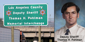 The interchange of I-10
and I-710 in the County of Los Angeles (LA 026.47) is named the "Los
Angeles County Deputy Sheriff Thomas H. Pohlman Memorial Interchange".
It was named in memory of Thomas H. Pohlman,a sheriff’s deputy with
the Los Angeles County Sheriff’s Department. Deputy Sheriff Pohlman
was born in July 1950, and was appointed as a sheriff’s deputy on
May 29, 1973. On April 19, 1978, Deputy Sheriff Pohlman was on patrol when
he smelled ether, used in the manufacture of the drug PCP, coming from a
nearby house. As Deputy Sheriff Pohlman and his partner approached the
house, a man bolted from the home. Deputy Sheriff Pohlman pursued the
suspect on foot, while his partner went back to the squad car to radio for
assistance. Deputy Sheriff Pohlman caught the suspect, and, while the
suspect was being handcuffed, the suspect gained control of Deputy Sheriff
Pohlman’s revolver and shot him. Deputy Sheriff Pohlman died at the
scene. Named by Assembly Concurrent Resolution 121, Res. Chapter 192,
Statutes of 2016, 9/9/2016
The interchange of I-10
and I-710 in the County of Los Angeles (LA 026.47) is named the "Los
Angeles County Deputy Sheriff Thomas H. Pohlman Memorial Interchange".
It was named in memory of Thomas H. Pohlman,a sheriff’s deputy with
the Los Angeles County Sheriff’s Department. Deputy Sheriff Pohlman
was born in July 1950, and was appointed as a sheriff’s deputy on
May 29, 1973. On April 19, 1978, Deputy Sheriff Pohlman was on patrol when
he smelled ether, used in the manufacture of the drug PCP, coming from a
nearby house. As Deputy Sheriff Pohlman and his partner approached the
house, a man bolted from the home. Deputy Sheriff Pohlman pursued the
suspect on foot, while his partner went back to the squad car to radio for
assistance. Deputy Sheriff Pohlman caught the suspect, and, while the
suspect was being handcuffed, the suspect gained control of Deputy Sheriff
Pohlman’s revolver and shot him. Deputy Sheriff Pohlman died at the
scene. Named by Assembly Concurrent Resolution 121, Res. Chapter 192,
Statutes of 2016, 9/9/2016
(Image source: Twitter; Find a Grave)
 Classified Landcaped Freeway
The following segments are designated as Classified Landscaped Freeway:
| County | Route | Starting PM | Ending PM |
| Los Angeles | 710 | 6.80 | 9.82 |
| Los Angeles | 710 | 11.86 | 12.55 |
| Los Angeles | 710 | 12.80 | 17.34 |
| Los Angeles | 710 | 17.66 | 21.01 |
| Los Angeles | 710 | 21.76 | 22.17 |
| Los Angeles | 710 | 22.37 | 22.67 |
| Los Angeles | 710 | 22.91 | 25.44 |
| Los Angeles | 710 | 26.40 | 26.53 |
| Los Angeles | 710 | R26.53 | R27.19 |
| Los Angeles | 710 | R32.34 | R32.72 |
 Interstate Submissions
  Approved as 139(a) non-chargeable interstate in 1983; the portion from Ocean Blvd in Long Beach to Route 710 was approved
as 139(b) non-chargeable mileage in 1984. The portion from Route 10 to
Route 210 is a subject of a long legal battle and is not yet constructed,
except for the stub Route 710 at the I-210/Route 134/Route 710
interchange.
Approved as 139(a) non-chargeable interstate in 1983; the portion from Ocean Blvd in Long Beach to Route 710 was approved
as 139(b) non-chargeable mileage in 1984. The portion from Route 10 to
Route 210 is a subject of a long legal battle and is not yet constructed,
except for the stub Route 710 at the I-210/Route 134/Route 710
interchange.
 Exit Information
 Other WWW Links
 Freeway
[SHC 253.1] Until 1/1/2024: Entire route. Added to the Freeway and Expressway system in 1959.
In 2019, both AB 29 (Chapter 791, 10/21/2019) and SB 7 (Chapter 835, 10/21/2019) were chaptered, and SB 7, being chaptered last, took precedence. SB 7 changed the definition of the route in the freeway and expressway system to prepare for relinquishment of the Route 710 gap (note that it did not change the definition of the route itself):
(2) Route 1 near the City of Long Beach to Route 10 near the City of Alhambra.
(3) Route 10 near the City of Alhambra to Route 210 near the City of Pasadena.
SB 7 explicitly requires, that as of 1/1/2024, items (2) and (3) are changed to
(2) Route 1 near the City of Long Beach to Route 10 near the City of Alhambra Alhambra Avenue in the City of
Los Angeles.
(3) Route 10 near the City of Alhambra
California Boulevard in the City of Pasadena to Route 210.
This explicitly deletes the unconstructed portion of Route 710 from the freeway and expressway system. Note that the actual definition of the route in Article 3 of the Streets and Highway Code is unchanged.
 Statistics
Overall statistics for Route 710:
© 1996-2020 Daniel P. Faigin.
Maintained by: Daniel P. Faigin
<webmaster@cahighways.org>.
 Route 680
 Route 740