
 California Highways:
Click here for a key to the symbols used. An explanation of acronyms may be found at the bottom of the page.
 Routing
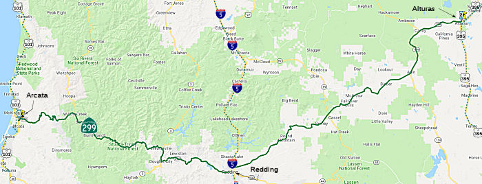 From Route 101 near Arcata to Route 395 at Alturas.
 Post 1964 Signage History
▸As defined in 1963, this segment was actually two segments: “(a) Route 101 near Arcata to Route 5 at Redding via Weaverville. (b) Route 5 at Redding to Route 395 at Alturas.”
▸In 1998, Chapter 828 combined segments (a) and (b), giving “(a) Route 101 near Arcata to Route 395 at Alturas.” This eliminated the discontinuity in Redding, which arose due to a short multiplex with Route 273 in downtown Redding. At the northerly (now southerly) junction of Route 299 (Eureka Way) and Route 273 (Market Street), Route 299 eastbound went south on Route 273 for about two blocks, then made a left turn towards Tehama Street east to the Route 299 freeway headed towards I-5; Route 299 westbound from I-5 merged into Shasta Street, then made the right turn on Market (Route 273) and then the left to Eureka Way. Note that this short multiplex was not of equal distances westbound and eastbound.
Between Adin and Canby, this route is cosigned with Route 139, although it is legislatively Route 299.
 In 1975, the CTC circulated notices about the rescinding of previous freeway
adoptions. Specifically, the CTC proposed to rescind the freeway adoption
for the segment from the Trinity County line to 0.3 mi E of Clear Creek
(SHA 0.0 to 9.0), and the segment from 0.7 mi W of Kennedy Drive to Iron
Mountain Road (SHA 15.9 to 20.4).
In 1975, the CTC circulated notices about the rescinding of previous freeway
adoptions. Specifically, the CTC proposed to rescind the freeway adoption
for the segment from the Trinity County line to 0.3 mi E of Clear Creek
(SHA 0.0 to 9.0), and the segment from 0.7 mi W of Kennedy Drive to Iron
Mountain Road (SHA 15.9 to 20.4).
(Source: Published Caltrans Notice, 1975, via Joel Windmiller,
2/25/2023)
In 2002, a highway location routing was adopted along Lake Boulevard from Route 273 to I-5. This segment of Route 273 from Route 299 at Market Street to Route 273 at Lake Boulevard will be cosigned Route 273/Route 299. The former Route 299 segment from Route 299 at Market Street to I-5 will be designated as Route 44.
The connecting segment of US 395 between the end of this segment and the start of the next segment is cosigned as US 395/US 299, although it is legislatively US 395.
 Pre 1964 Signage History
The first segment of future Route 299 was defined by 1903 Legislative Chapter 366 specification of the corridor of the Trinity-Humboldt State Highway:
"for the purposes of locating and surveying a proposed highway from a point on the Trinity River near the town of North Fork (also known as Helena), thences W-ly down said river to connect with the existing road in Humboldt County."
The 1909 Bond Act defined LRN 20 as a route between Redding and Weaverville, and LRN 28 as a route between Redding and Alturas. 1911 Legislative Chapter 498 defined much of LRN 28 as part of the Lassen State Highway:
"That certain highway known as the county road and beginning on the boundary line between Shasta and Lassen Counties in the NE corner of T37N R6E and running and extending through T38N R6E, T38N R7E, T38N R8E, to the Modoc County Line...shall be designated and known as the Lassen State Highway."
LRN 20 was extended as part of the 1915 Bond Act, which the segment originating at LRN 1/Redwood Highway in Arcata east to Douglas City via Weaverville.
Translating this to modern terms: The segment of Route 299 between US 101 and Redding was LRN 20. The portion between US 101 and Weaverville was defined in 1915; the remainder of the route to I-5 in Redding was defined in 1909. Between Redding and US 395 it was LRN 28: The portion between Redding and Alturas was defined in 1909; the remainder was defined in 1915.
However, the original signage of the route in 1934 was as Route 44, which ran from US 101 near Arcata east via LRN 20 to US 99 in Redding and via LRN 28 to Route 7 (future US 395) in Alturas. Route 440 was announced as a new route from Redding east via the 1933 extension of LRN 20 to Lassen Volcanic National Park. California petitioned to make this a US route in August 1934 (as well as to make Route 7 a US route); US 299 and US 395, along with numerous other US Route designations in California were approved by the AASHO Executive Committee Meeting during November of 1934. US 299 ran from US 101 to US 395. In 1935, it was re-signed as US 299. The original Route 44 was swapped to US 299 by 1935. At some point between 1935-1937, Route 440 was reassigned as Route 44.
The original routing of US 299 from Arcata east through Blue Lake used
the following alignment:
(Source: Gribblenation Blog (Tom Fearer), "US Route 299 and modern California State Route 299", October 2021)
The original alignment of US 299 within Redding followed LRN 20 via
Eureka Way to US 99/LRN 3 at Market Street. US 299 multiplexed US 99
south on Market Street towards Parkview Avenue onto LRN 28. From
Parkview Avenue US 299 followed Parkview Avenue and Smile Place over the
1908 Redding Free Bridge over the Sacramento River. Upon crossing
the Sacramento River US 299/LRN 28 followed Canby Road, Dana Drive and Old
Alturas Road east toward Bella Vista.
(Source: Gribblenation Blog (Tom Fearer), "US Route 299 and modern California State Route 299", October 2021)
In 1935, a new Sacramento River Bridge and new alignment of US 99/US 299/LRN 3 opened. US 299 eastbound was realigned over the new Sacramento
River Bridge north on Market Street via a multiplex of US 99/LRN 3.
US 299 split from US 99/LRN 3 eastward onto LRN 28 at Lake
Boulevard.
(Source: Gribblenation Blog (Tom Fearer), "US Route 299 and modern California State Route 299", October 2021)
The modern Route 299 alignment uses a freeway grade over the Mad River
where it meets a junction with Route 200 where it drops to a two-lane
configuration east of Blue Lake. The new alignment of Route 299 first
appeared as a proposed route east of Blue Lake on the 1969 State Highway
Map. The modern freeway bypass of Blue Lake on Route 299 appears by the
1975 Edition of the State Highway Map.
(Source: Gribblenation Blog (Tom Fearer), "US Route 299 and modern California State Route 299", October 2021)
Note: A detailed history of Route 299 and its development can be found in the Gribblenation Blog (Tom Fearer), "US Route 299 and modern California State Route 299", October 2021. It is much too long to summarize here.
 Status
This is constructed to freeway standards from Route 101 to E of Blue Lake, and from Route 5 to the Old Oregon Trail.
The SAFETEA-LU act, enacted in August 2005 as the reauthorization of TEA-21, provided the following expenditures on or near this route: High Priority Project #2080: Reduce congestion and boost economies through safer access to the coast by realigning Route 299 between Trinity and Shasta Counties. $5,600,000.
Arcata to Willow Creek (Route 96)
In August 2012, the CTC approved SHOPP funding of $3,603,000 on Route 299 in Humbolt Cty PM HUM 0.0/43.0 near Arcata, from Route 299/US 101 Separation to South Fork Trinity River Bridge. Outcome/Output: Install new metal beam guard railing to reduce the number and severity of the run-off-road collisions and to comply with the recommendations of the Traffic Investigations Report.
Arcata 101 Merge Improvement Project (01-Hum-299, PM 0.0)
") The following project was included in the final adopted 2018 SHOPP in March 2018: PPNO 2424. 01-Humboldt-101 88.3/88.6. On US 101 In Arcata, from north of Route 299/Route 101 Connector to 0.2 mile
south of Guintoli Lane Overcrossing. Construct auxiliary lane to improve
merging movements. Begin Con: 5/1/2022. Total Project Cost: $8,086K.
The following project was included in the final adopted 2018 SHOPP in March 2018: PPNO 2424. 01-Humboldt-101 88.3/88.6. On US 101 In Arcata, from north of Route 299/Route 101 Connector to 0.2 mile
south of Guintoli Lane Overcrossing. Construct auxiliary lane to improve
merging movements. Begin Con: 5/1/2022. Total Project Cost: $8,086K.
In October 2019, the CTC amended the SHOPP on this
project: 01-Hum-101 88.3/88.6. PPNO 2424. Proj ID 0115000043. EA 0E890.
Route 101 In Arcata, from north of Route 299/Route 101 Connector to 0.2
mile south of Guintoli Lane Overcrossing. Construct auxiliary lane to
improve merging movements. Adjust total cost due to R/W capital change
from $15K to $532K.
(Source: October 2019 CTC Agenda, Agenda Item
2.1a.(1) Amendment Item 7)
The 2020 SHOPP, approved in May 2020, included the
following Mobility item of interest (carried over from the 2018 SHOPP):
01-Humboldt-101 PM 88.3/88.6 PPNO 2424 Proj ID 0115000043 EA 0E890. US 101
in Arcata, from north of Route 299/Route 101 Connector to 0.2 mile south
of Giuntoli Lane Overcrossing. Construct auxiliary lane to improve merging
movements. Programmed in FY21-22, with construction scheduled to start in
May 2022. Total project cost is $8,603K, with $4,630K being capital (const
and right of way) and $3,973K being support (engineering, environmental,
etc.),
(Source: 2020 Approved SHOPP a/o May 2020)
In January 2021, the CTC approved for future
consideration of funding the following project: 01-Hum-101, PM 88.3
01-Hum-299, PM 0.0 Arcata 101 Merge Improvement Project. Extend the Route 299 entrance ramp onto northbound US 101 to the Giuntoli Lane exit ramp in
Humboldt County. (ND) (PPNO 2424) (SHOPP). The project is located on US 101 in Arcata in Humboldt County. The Department is proposing to improve
merging movements by extending the Route 299 entrance ramp onto northbound
US 101 to the Giuntoli Lane exit ramp at the Route 299/US 101
Separation. This project is fully funded and is currently programmed
in the 2020 SHOPP for a total of
$8,603,000 which includes Construction (capital and support) and Right of
Way (capital and support). Construction is estimated to begin in 2022-23.
The scope, as described for the preferred alternative, is consistent with
the project scope programmed by the Commission in the 2020 SHOPP. A
Negative Declaration (ND) has been completed. The project will result in
less than significant impacts to the environment.
(Source: January 2021 CTC Agenda, Agenda Item
2.2c.(1))
In March 2021, the CTC amended this project in the
SHOPP: (1d) #2. 01-Hum-101 88.3/88.6 PPNO 2424 ProjID 0115000043 EA
0E890. US 101 In Arcata, from north of Route 299/Route 101 Connector to
0.2 mile south of Giuntoli Lane Overcrossing. Construct auxiliary lane to
improve merging movements. Amended to increase construction capital, R/W
capital, and to delay completion. Increase in construction capital from
$4,098K to $5,042K is due to the addition of maintenance vehicle pullouts,
security fencing, rock slope protection, enhanced structural section, and
aerially deposited lead material removal. Increase in R/W capital from
$523K to $709K is due to the temporary construction easements required in
order to remove old fencing and constructing new fence. Revised total:
9,724K Delay of project by one year to FY22-23 will avoid traffic handling
conflicts with an adjacent project.
(Source: March 2021 CTC Agenda, Agenda Item
2.1a.(1d) #2)
In January 2023, the CTC approved for future
consideration of funding the following project for which a Negative
Declaration (ND) and an Addendum have been completed: Arcata 101
Merge Improvement Project. US 101 and Route 299, in Humboldt County
(01-Hum-101, PM 88.3; 01-Hum-299, PM 0.0). Extend the Route 299
entrance ramp onto northbound US 101 to the Giuntoli Lane exit ramp, in
Humboldt County. (PPNO 2424). This project is located on US 101 at
postmile 88.3 and SR 299 at postmile 0.0, in Humboldt County. The
Department is proposing to improve merging movements by extending the
Route 299 entrance ramp onto northbound US 101 to the Giuntoli Lane exit
ramp at the Route 299/US 101 Separation. This project is currently
programmed in the 2022 State Highway Operations Program (SHOPP) for a
total of $9,724,000 which includes Construction (capital and support) and
Right of Way (capital and support). Construction is estimated to begin in
2022-23. The scope, as described for the preferred alternative, is
consistent with the project scope programmed by the Commission in the 2022
SHOPP. A copy of the ND has been provided to Commission staff. The
Commission approved the project for future consideration of funding on
January 28, 2021, under Resolution E-21-02. Construction associated with
the proposed maintenance pullout on Route 299 has been removed from the
scope of work and the overlay of westbound Route 299 to northbound US 101
interchange has been added. An outdated service pedestal, concrete pad,
and conduit on Giuntoli Lane would be removed and replaced along a similar
alignment. The Department subsequently completed an Addendum to the ND
pursuant to the California Environmental Quality Act. The Department has
approved this project for construction. This approval and the Addendum
will satisfy the environmental requirements for this stage of the planning
process.
(Source: January 2023 CTC Agenda, Agenda Item 2.2c.(5))
In January 2023, the CTC approved a construction /
construction support phase allocation of $720,000. 01-Hum-101 88.3/88.6.
PPNO 01-2424; ProjID 0115000043; EA 0E890. US 101 In Arcata, from Route 299/Route 101 Connector to 0.2 mile south of Giuntoli Lane Overcrossing.
Outcome/Output: Construct auxiliary lane to improve merging movements by
extending westbound Route 299 onramp to the Giuntoli Lane offramp.
Allocation: CON ENG $1,546,000; CONST $5,042,000. CEQA - ND, 10/1/2020;
Re-validation 11/28/2022. NEPA - CE, 10/1/2020; Re-validation 11/28/2022.
Future consideration of funding approved under Resolution E-21-02; January
2021. The CTC approved an addendum for the previously approved Future
Consideration of Funding under Resolution E-23-09; January 2023.
(Source: January 2023 CTC Agenda, Agenda Item 2.5b.(1) #1)
In October 2019, the CTC approved the following pre-construction
allocation: 01-Hum-299 R1.5/R2.0. PPNO 2430 Proj ID 0116000018 EA 0F530.
Route 299 Near Arcata, from 1.5 miles east to 2.0 miles east of Route 101
at the Route 200/Route 299 Separation No. 04-0184. Establish standard
vertical clearance. PS&E $857,000 (Programmed) $1,010,000 (Allocated)
R/W Sup $26,000
(Source: October 2019 CTC Agenda, Agenda Item
2.5b.(2b) #2)
Blue Lake Storm Damage Relocation (01-Hum-299 R8.0/R8.8)
 In March 2021, the CTC amended the following long lead project
into the 2020 SHOPP: (1c) #1. 01-Hum-299 R8.0/R8.8 PPNO 2535 ProjID
0120000032 EA 0J801. Route 299 Near Blue Lake, from 0.9 mile east to 1.7
miles east of Blue Lake Boulevard. Restore storm damaged roadway by
relocating on a new alignment and construct retaining wall. (Long Lead
Project) PA&ED $2,171K; ⊘PS&E
$1,989K; ⊘R/W Sup $168K; ⊘Con Sup $4,668K; ⊘R/W
Cap $993K; ⊘Const Cap $49,684K
TOTAL $59,673K. “⊘”
indicates phase not programmed. Begin const. 3/19/2025. Note:
Complex and lengthy geotechnical investigations are required to evaluate
various landslide repair solutions.
In March 2021, the CTC amended the following long lead project
into the 2020 SHOPP: (1c) #1. 01-Hum-299 R8.0/R8.8 PPNO 2535 ProjID
0120000032 EA 0J801. Route 299 Near Blue Lake, from 0.9 mile east to 1.7
miles east of Blue Lake Boulevard. Restore storm damaged roadway by
relocating on a new alignment and construct retaining wall. (Long Lead
Project) PA&ED $2,171K; ⊘PS&E
$1,989K; ⊘R/W Sup $168K; ⊘Con Sup $4,668K; ⊘R/W
Cap $993K; ⊘Const Cap $49,684K
TOTAL $59,673K. “⊘”
indicates phase not programmed. Begin const. 3/19/2025. Note:
Complex and lengthy geotechnical investigations are required to evaluate
various landslide repair solutions.
(Source: March 2021 CTC Agenda, Agenda Item
2.1a.(1c) #1)
In March 2021, the CTC approved the following
pre-construction support phase allocation(s): (2a) #2. $2,171,000
(PA&ED). 01-Hum-299 R8.0/R8.8. PPNO 01-2535; ProjID 0120000032; EA
0J801. Route 299 Near Blue Lake, from 0.9 mile east to 1.7 miles
east of Blue Lake Boulevard. Restore storm damaged roadway by relocating
on a new alignment and construct retaining wall. (Long Lead Project)
(Concurrent Amendment under SHOPP Amendment 20H-006; March 2021.)
Prog Year 24-25.
(Source: March 2021 CTC Agenda, Agenda Item
2.5b.(2a) #2)
In June 2022, the CTC amended this project in the SHOPP
as follows: 01-Hum-299 R8.0/R8.8. PPNO 01-2535; ProjID 0120000032; EA
0J801. Route 299 Near Blue Lake, from 0.9 mile east to 1.7 miles east of
Blue Lake Boulevard. Restore storm damaged roadway by relocating on
a new alignment and construct retaining wall. Note: The
slope repair work at one of the locations in project EA 0H431/PPNO 01-2492
overlaps with this project. Due to ongoing geologic investigations,
proximity and complexity of the two locations and the evolving repair
strategy, the two locations are being combined into this project.
This change is reflected in revised performance measures and scope
description. The cost change will be addressed in future after the
scope and design is more refined.
(Source: June 2022 CTC Agenda, Agenda Item
2.1a.(1d) #6)
In August 2023, the CTC approved the following SHOPP
Pre-Construction Phase (environmental support, design, and R/W support)
allocation: $2,157,000. 01-Hum-299 R8/R8.8. PPNO 01-2535; ProjID
0120000032; EA 0J801. Route 299 Near Blue Lake, from 0.9 mile east to 1.7
miles east of Blue Lake Boulevard. Restore storm damaged roadway by
relocating on a new alignment. Two month allocation time extension for
PS&E and R/W Sup approved under Waiver 23-72; June 2023. Allocation:
PS&E $1,989,000; R/W Sup $168,000.
(Source: August 2023 CTC Agenda, Agenda Item 2.5b.(2a) #2)
In August 2019, the CTC approved the following emergency G-11 allocation:
01-Hum-299 R8.5/R9.0. PPNO 2531 Proj ID 0119000104 EA 0J800. On Route 299
Near Blue Lake, from 1.4 to 1.9 miles east of Blue Lake Boulevard.
Following a series of heavy rain beginning in January 2019, a portion of
the roadway began to settle. Department staff monitored the settlement and
placed asphalt in the sunken section of roadway. On April 19, 2019, the
Department determined the settlement was beyond its abilities and an
emergency contract is required. This project will reconstruct and restore
the roadway alignment and profile while ongoing geotechnical
investigations continue. $4,500,000 : $1.500K Con Eng; $3,000K Const.
(Source: August 2019 CTC Agenda, Agenda Item
2.5f.(1) #4)
Blue Lake Widening (01-Hum-299 R14.7/R15.7)
In January 2014, the CTC approved for future consideration of funding a project in Humboldt County that will construct eight-foot wide shoulders and close a 1,100-foot gap in the climbing lane segments on a portion of Route 299 near the community of Blue Lake. The project is programmed in the 2012 State Highway Operation and Protection Program. The total estimated cost is $4,645,000 for capital and support. Construction is estimated to begin in Fiscal Year 2013-14.
In June 2017, the CTC added the following to the SHOPP: 01-Hum-299 R14.7/R15.7 On Route 299: Near Blue Lake, from 2.2 miles east of Simpson Road to 3.2 miles east of Simpson Road. Widen shoulders, and install rumble strips and guardrailing. $0 (R/W) $1,386,000 (C) PA&ED: 09/01/2018 R/W: 07/01/2019 RTL: 07/01/2019 BC: 12/01/2019
In May 2019, the CTC approved the following SHOPP
Amendment: 01-Hum-299 R14.7/R15.7. PPNO 2435. ProjID 0116000045. Route 299
Near Blue Lake, from 2.2 miles east of Simpson Road to 3.2 miles east of
Simpson Road. Widen shoulders, and install rumble strips and guardrailing.
Amend Const Capital from $1,386K to $1,584K. Increase in construction
capital is due to the addition of a maintenance vehicle pullout area to
improve worker safety.
(Source: May 2019 CTC Agenda Item 2.1a.(1)
Amendment item #5)
In October 2019, the CTC approved the following SHOPP
Safety Allocation: 01-Hum-299 R14.7/R15.7 PPNO 2435 Proj ID 0116000045 EA
0F690. On Route 299 Near Blue Lake, from 2.2 miles east to 3.2 miles east
of Simpson Road. Outcome/Output: Improve safety by widening shoulders,
installing rumble strips and high visibility striping, and upgrading
guardrails. This project will reduce the number and severity of
collisions. $1,944,000
(Source: October 2019 CTC Agenda, Agenda Item
2.5f.(3) #1)
In December 2011, the CTC approved for future consideration of funding a project in Humboldt County to repair and stabilize two segments of Route 299 near Blue Lake (01-HUM-299, PM 20.2/20.5); including realigning lanes, installing underdrains and constructing two tieback walls. The project is programmed in the 2010 State Highway Operation and Protection Program (SHOPP). The total estimated project cost is $21,069,000 for capital and support. Construction is estimated to begin in Fiscal Year 2011-12. The scope, as described for the preferred alternative, is consistent with the project scope programmed by the Commission in the 2010 SHOPP. The project will mitigate potential impacts to biological resources and hydrology/water quality to a less than significant level. Potential impacts to hydrology/water quality and biological resources in the project area will be mitigated through restoration of existing wetlands and riparian areas to pre-project conditions. On-site revegetation planting will be provided to replace trees and shrubs removed during project construction.
Cedar Creek Widening (01-Hum-299 20.5/30.2)
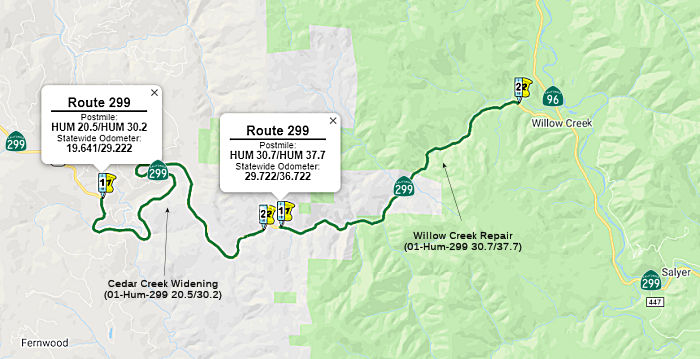 In December 2018, it was reported that the CTC allocated $885,000 of support costs for the
advancement of a project on Route 299 in Humboldt County near Willow Creek
from 1.5 miles east of East Blair Road to 0.4 miles west of Cedar Creek
Road. The proposed project would widen shoulders. The CTC minutes showed
the following for this: 01-Hum-299 20.5/30.2 PPNO 2427. Project No.
0116000010 Route 299 Near Willow Creek, from 1.5 mile east of East Bair
Road to 0.4 mile west of Cedar Creek Road, at various locations. Widen
shoulders.
In December 2018, it was reported that the CTC allocated $885,000 of support costs for the
advancement of a project on Route 299 in Humboldt County near Willow Creek
from 1.5 miles east of East Blair Road to 0.4 miles west of Cedar Creek
Road. The proposed project would widen shoulders. The CTC minutes showed
the following for this: 01-Hum-299 20.5/30.2 PPNO 2427. Project No.
0116000010 Route 299 Near Willow Creek, from 1.5 mile east of East Bair
Road to 0.4 mile west of Cedar Creek Road, at various locations. Widen
shoulders.
(Source: Redheaded Blackbelt, 12/11/2018; December 2018 CTC Minutes, Agenda Item 2.5b(2a), Item 2)
In June 2019, the CTC approved the following SHOPP
scope amendment: 01-Hum-299 20.5/30.2 PPNO 2427 ProjID 0116000010. Route 299 Near Willow Creek, from 1.5 mile east of East Bair Road to 0.4 mile
west of Cedar Creek Road, at various locations. Widen shoulders. Increase
in construction capital and support is due to additional quantities and
higher unit prices identified after more detailed site evaluations and
design calculations. Reduction in R/W capital is due to the elimination of
property acquisitions. Updated total cost: $10,950K
(Source: June 2019 CTC Minutes, Agenda Item
2.1a.(1) Scope Item 5)
In August 2020, the CTC received notice of the
following delegated allocation: $10,343,000. 01-Hum-299 20.5/30.2. PPNO
01-2427 ProjID 0116000010 EA 0F460. Route 299 Near Blue Lake, from 1.5
mile east of East Bair Road to 0.4 mile west of Cedar Creek Road, at four
locations. Outcome/Output: Improve safety by widening shoulders, upgrading
guardrails, constructing rumble strips and retaining walls, overlaying
existing roadway, and adding high visibility striping. This project will
reduce the number and severity of collisions.
(Source: August 2020 CTC Minutes, Agenda Item
2.5f.(3) #1)
Willow Creek Repair (~ 01-Hum-299 30.7/37.7)
In May 2017, the CTC authorized $2.1M in emergency SHOPP funding on Route 299 near Willow Creek, at 0.1 mile north of Cedar Creek Road (01-Hum-299 30.6). Beginning on January 7, 2017 to February 6, 2017, a series of storm events reactivated a previously stabilized slide beyond Department forces ability to control, damaging the roadway. The project will remove slide debris, stabilize slope, install rock slope protection (RSP), and repair roadway. As per geotechnical recommendation, this slide is still active and intervention is imperative to curtail acceleration of slide movement. This work is necessary to prevent further slope failure and roadway damage, and restore safe passage to the traveling public
PPNO 2426: 01-Hum-299 30.7/37.7
In June 2017, the CTC added the following to the SHOPP: 01-Hum-299 30.7/37.7 On Route 299: Near Willow Creek, from 0.1 mile east of Cedar Creek Road to 1.1 miles west of Route 96. Widen shoulders, place high-friction surface treatment (HFST), install rumble strips, guardrail, and cable net drapery. $19,000 (R/W) $11,388,000 (C) PA&ED: 07/01/2018 R/W: 07/01/2019 RTL: 08/01/2019 BC: 01/01/2020
In May 2019, the CTC approved the following SHOPP
Preliminary Phase allocation: Item 2. 01-Hum-299 30.7/37.7 Route 299 Near
Willow Creek, from 0.1 mile east of Cedar Creek Road to 1.1 miles west of
Route 96. Widen shoulders, place High Friction Surface Treatment (HFST),
install rumble strips, guardrail, and cable net drapery. PPNO 2426. ProjID
0116000011. PS&E $1,668,000 R/W Sup $45,000
(Source: May 2019 CTC Minutes, Agenda Item 2.5b.(2a) Item 2)
In August 2020, the CTC amended the SHOPP for this
project as follows: 01-Hum-299 PM 30.7/37.7. PPNO 2426 ProjID 0116000011
EA 0F470. Route 299 near Willow Creek, from 0.1 mile east of Cedar Creek
Road to 1.1 miles west of Route 96. Widen shoulders, place High Friction
Surface Treatment (HFST), install rumble strips, guardrail, and cable net
drapery. Changes to Con Support $2,510K $2,248K
and Const Cap $11,388K $11,318K. Note: Split
environmental mitigation from this project into EA OF471/PPNO 01-2426M.
(Source: August 2020 CTC Agenda, Agenda Item
2.1a.(1d) #1)
Related to the above, in August 2020 the CTC also
approved a financial allocation for construction and construction support
of $15,489,000. 01-Hum-299 PM 30.7/37.7. PPNO 01-2426. ProjID
0116000011 EA 0F470. Route 299 Near Willow Creek, from 0.1 mile east of
Cedar Creek Road to 1.1 miles west of Route 96. Outcome/Output: Improve
safety by widening shoulders, placing High Friction Surface Treatment
(HFST), installing rumble strips, upgrading guardrail, and installing
cable net drapery. This project will reduce the number and severity of
collisions.
(Source: August 2020 CTC Agenda, Agenda Item
2.5b.(1) #4)
PPNO 2522: 01-Hum-299 30.7/33.4
In June 2019, the CTC approved the following SHOPP
amendment: 01-Hum-299 30.7/33.4 PPNO 2522 ProjID 0119000025. Route 299
Near Willow Creek, from 0.1 mile east of Cedar Creek Road to 0.2 mile east
of East Fork Willow Creek Bridge. Widen shoulders and improve curves at
three locations. PA&ED $2,050K PS&E $2,839K R/W Sup $198K Con Sup
$6,599K R/W Cap $89K Const Cap $27,989K Total $39,764K Begin const.
10/2022.
(Source: June 2019 CTC Minutes, Agenda Item
2.1a.(1) CR Item 22)
In June 2019, the CTC approved the following SHOPP
support phase allocation: $2,050,000 01-HUM-299 30.7/33.4 PPNO 2522 ProjID
0119000025. Route 299 Near Willow Creek, from 0.1 mile east of Cedar Creek
Road to 0.2 mile east of East Fork Willow Creek Bridge. Widen shoulders
and improve curves at three locations. PA&ED $2,050,000. (Concurrent
amendment under SHOPP Amendment 18H-010.)
(Source June 2019 CTC Minutes, Agenda Item
2.5b.(2a) Item 4)
The 2020 SHOPP, approved in May 2020, included the
following Collision Reduction item of interest (carried over from the 2018
SHOPP): 01-Humboldt-299 PM 30.7/33.4 PPNO 2522 Proj ID 0119000025 EA
0J410. Route 299 near Willow Creek, from 0.1 mile east of Cedar Creek Road
to 0.2 mile east of East Fork Willow Creek Bridge. Widen shoulders and
improve curves at three locations. Programmed in FY21-22, with
construction scheduled to start in October 2022. Total project cost is
$39,764K, with $28,078K being capital (const and right of way) and
$11,686K being support (engineering, environmental, etc.),
(Source: 2020 Approved SHOPP a/o May 2020)
In May 2021, the CTC approved the following
pre-construction support phase allocation(s): (2a) #1. $2,839,000
(PS&E); $198,000 (R/W Supp). 01-Hum-299 30.7/33.4. PPNO 01-2522;
ProjID 0119000025; EA 0J410. Route 299 Near Willow Creek, from 0.1 mile
east of Cedar Creek Road to 0.2 mile east of East Fork Willow Creek
Bridge. Widen shoulders and improve curves at three locations. Prog year
21-22.
(Source: May 2021 CTC Agenda, Agenda Item 2.5b.(2a)
#1)
In August 2022, the CTC approved the following
amendment to the SHOPP: 01-Hum-299 30.7/33.4. PPNO 01-2522; ProjID
0119000025; EA 0J410. Route 299 Near Willow Creek, from 0.1 mile east of
Cedar Creek Road to 0.2 mile east of East Fork Willow Creek Bridge. Widen
shoulders and improve curves at three locations. Allocation Changes ($
× 1,000): Con Sup $6,599 ⇨ $6,308; Const Cap: $27,909 ⇨
$27,723; Total $39,764 ⇨ $39,207. Concurrent CONST and CON ENG
allocation under Resolution FP-22-10; August 2022. Note: Split
environmental mitigation project EA 0J411/PPNO 01-2522M from parent
project EA 0J410/PPNO 01-2522.
(Source: August 2022 CTC Agenda, Agenda Item
2.1a.(1d) #5)
In October 2020, the CTC approved an allocation request for $5,456,000
for 01-Hum-299 38.9/39.5, PPNO 01-2434 ProjID 0116000044 EA 0F680. The
project is located on Route 299 near Willow Creek, in the County of
Humboldt. The project will widen shoulders, upgrade curb ramps to current
Americans with Disabilities Act (ADA) standards and install a bus
turn-out. The project was programmed in 2016 SHOPP for $2,805,000 in
construction capital and $1,103,000 in construction support, with a
planned delivery in 2019-20. The project Plans Specifications and Estimate
(PS&E) phase was completed in May 2020, and the most recent Engineers
Estimate (EE) was completed in June 202, which updated the construction
capital cost of the project to $4,353,000; an increase of $1,548,000 or
167.8 percent over the programmed funds. The construction support cost has
not increased from the originally programmed amount of $1,103,000. The
primary reason for the cost increase is due to the additional work added
to the original scope. The original alternatives listed in the PID focused
on widening on the west side of the highway by cutting into the hillside
on the right. However, in an effort to avoid any impact to residences
along the east side of the highway, the Department did not consider any
widening to the east. The $2,594,000 originally programmed project was
based on an alternative that proposed shoulder widening by shifting the
alignment to the west into an existing slope, and constructing bus turnout
and ADA curb ramps, as well as the complete street improvements. The June
2019 Project Report (PR) evaluated four design alternatives, which
included three alternatives for work on the west side of highway and one
alternative on the east of the highway. All four alternatives were
estimated to cost more than the programmed project budget due to higher
item quantities and unit prices for earthwork, paving, structural section,
landscape, and traffic handling. Due to concerns with the high capital
cost of other alternatives, an alternative to widen to the west on the
existing highway was selected, and the PR was approved. However, the
selected alternative cost exceeds the programmed amount by more than 20
percent. The project design alternative that was originally planned in the
PIR included an existing cut slope on the west side of the highway that
was determined to unsuitable for the project. A geotechnical investigation
of the site concluded that there was a potential high risk of failure
during construction. The Department concluded that to solve the slope
stability problem, the highway widening must be to the east, and a
Mechanically Stabilized Embankment (MSE) wall, estimated to cost $560,000,
must be constructed along with it. In addition, during the design phase,
it was determined that widening to the west would cause sight distance
issues, which could be avoided if the widening were to be to the east and
if a wall was constructed. It was also determined that the super elevation
would need to be corrected to standard, and by not fully solving this
design safety issue, the project would not meet its stated purpose and
need statement. This additional structural section resulted in an increase
of $532,000. Finally, an increase of $276,000 was realized due to
additional traffic handling measures due to implementation of the
Department’s Construction Work Zone Speed Limit Reduction Guidelines
(April 2020).
(Source: August 2020 CTC Agenda, Agenda Item
2.5d.(2))
Willow Creek to Redding (I-5)
In January 2024, Caltrans released the draft 2024 SHOPP, which contained
the following long-lead project: 02-Trinity-299 6.26 /6.5; PPNO 02-3829;
ProjID 0221000119; EA 2J630. Route 299 Near Salyer, at from 0.1 mile west
to 0.3 mile east of Gray Creek Bridge № 05-0044. Replace bridge and
roadway on new alignment, and construct retaining wall and guardrail.
(Long Lead Project) Note: There are listed and endangered species and
historic rock walls within the project limits. Drainage will also
need to be surveyed for jurisdictional features to assess need for permits
and mitigation. Consultation with Tribal groups to determine impacts
from project may be required. Extensive environmental evaluations and
permitting will be required for the project. Proposed ($ × 1000):
PA&ED: $3,500; PS&E: $2,440; R/W $124; R/W Sup $130; Con $27,720;
Con Sup: $3,820; Total: $37,734. Only PA&ED phase is authorized.
Begin Con: 4/3/2029.
(Source: 2024 Draft SHOPP v4.0, 1/31/2024)
In March 2023, the CTC approved the following amendment to the 2022
SHOPP: 02-Tri-299 15.0/25.7. PPNO 01-3701; ProjID 0218000011; EA 3H700.
Route 299 Near Del Loma, from 1.0 mile east of Trinity River Bridge to
west of Prairie Creek Road. Rehabilitate pavement, upgrade guardrail
and Transportation Management System (TMS) elements, widen lanes to make
standard, and rehabilitate drainage systems. Note: Additional R/W capital,
construction capital and support are needed to increase the size of
existing culverts for climate resiliency. This additional need will
be funded through Infrastructure Investment and Jobs Act (IIJA) funds.
Allocation ($ × 1,000): PA&ED $1,180; PS&E $1,360; R/W Sup
$70; Con Sup $1,860 $1,890; R/W Cap $70
$88; Const Cap $18,790 $19,090; TOTAL $23,338
$23,678. FY23-24
(Source: March 2023 CTC Agenda, Agenda Item 2.1a.(1d) #1)
Del Loma Turnouts (TRI 21.6-22.6)
The 2020 STIP, approved at the March 2020 CTC meeting,
programs $750K for PPNO 3771 "Del Loma, 21.6-22.6, down river turnouts
(SHOPP)", with $15K allocated in FY20-21, $178K in FY22-23, and $557K in
FY23-24.
(Source: March 2020 CTC Agenda, Item 4.7, 2020 STIP
Adopted 3/25/2020)
Big French Creek Road Project (~ TRI 23.27)
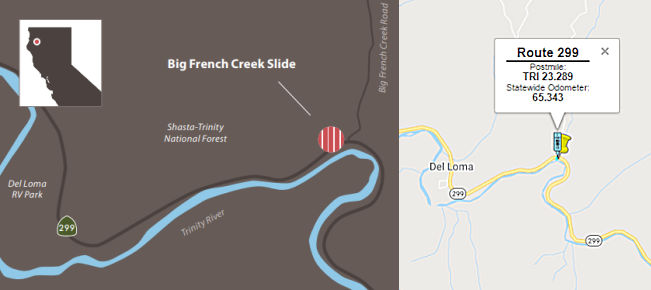 In Jnaury 2016, a major rockfall occurred onto Route 299 at Big French Creek. A few days
later, an emergency contract was awarded because of the threat to public
safety, and construction work began. The initial goal was to bring the
road back to normal by removing rock and soil, cleaning the roadway and
providing a 24-hour traffic-control system with spotters in place. A
temporary rockfall protection fence was installed atop barriers along the
centerline of the roadway. Originally, it was anticipated that repairs
would last six months during the winter season, and once calm weather
returned, the story would end there. Then a new mudslide destroyed the
protection fence.
In Jnaury 2016, a major rockfall occurred onto Route 299 at Big French Creek. A few days
later, an emergency contract was awarded because of the threat to public
safety, and construction work began. The initial goal was to bring the
road back to normal by removing rock and soil, cleaning the roadway and
providing a 24-hour traffic-control system with spotters in place. A
temporary rockfall protection fence was installed atop barriers along the
centerline of the roadway. Originally, it was anticipated that repairs
would last six months during the winter season, and once calm weather
returned, the story would end there. Then a new mudslide destroyed the
protection fence.
(Source: Unless otherwise noted, this information
comes from the Summer 2018 Caltrans Mile Marker)
Caltrans construction and geotechnical staff were deployed to find a more permanent fix, and realized they had to come up with a new approach. After several months of studies and site surveys, it was decided to create a catchment area that would hold 3,000 to 4,000 cubic yards of slide material. A new contract was awarded. During that time, Caltrans District 2’s teams worked with other agencies to comply with environmental laws in connection with the project. It also was necessary to find disposal sites for large amounts of debris, and work with local businesses and residents. As that work progressed, the area was hit by yet another slide toward the end of 2016. This development posed a serious threat to public safety, and forced Caltrans to close the highway and develop a new plan of action.
Caltrans was forced to temporarily close the road in January 2017. Meanwhile, road clearing took place despite more slides small and large and during one of the most severe winters in recent memory. After the highway shut down for 37 calendar days, a detour was opened two times per day, limited to school buses, teachers and emergency vehicles. The restored but restricted access raised hopes, but there was still a lot to do. And the threat of another slide always loomed over the project
In March 2017, as a result of Winter 2017 storm damage, an emergency SHOPP allocation of $11,000,000 was made for the portion of this route near Del Loma, at Big French Creek Road (02-Tri-299 23.3). A series of rock slides continue to occur at this location since January 16, 2016. Geotechnical investigations determined the slope will continue to shed rocks and soil. On February 1, 2016 an Emergency G -11 allocation (EA 2H090) was made to monitor and provide traffic control and site clearing as required to keep the route clear. However, the site continues to be under 24 hour oneway traffic control and rockfall monitoring. Further testing and analysis has determined a new temporary scope. This new project will construct a catchment area at the toe of slope with a temporary barrier wall and rockfall fencing. Supplemental funds are required to complete this work. Supplemental work includes shifting to a 7-day workweek to excavate over 200,000 cubic yards up the slope an additional 200 feet from the original slide due to continued storm events in the fall and winter of 2016 and increased slide activity, continuing 24 hour one-way traffic control, conducting slide monitoring, and constructing a temporary detour in the flood plain of the Trinity River using slide material. The work will restore the roadway to the traveling public without traffic restrictions, reduce the risk of roadway closures, and retain rock, debris and mud flows from the traveled way. A follow-up roadway preservation project (EA 0H680) is currently programmed with scope to be modified as a permanent solution.
Even after the storms ended, other challenges tested construction crews in 2017. They had to build a detour route that snaked through the very active work zone, coordinate the hydroseeding of denuded areas by helicopter, and even blast away a massive boulder that crashed onto the roadway. Construction was finished after almost two years after construction, at a cost of $40 million. By the time all work was done, Caltrans and its partners had literally moved a mountainside of material — 900,000 cubic yards — and installed a large, state-of-the-art catchment area, new guardrail, drainage system, a rockfall protection fence and wall, and repaved roadways, including disposal sites.
There are plans to add east and westbound passing lanes near Douglas City between Little Browns Creek Bridge and Trinity River Bridge 05-0018 (TRI R058.00). July 2005 CTC Agenda. (02N-Tri-299 55.7/57.7)
In January 2008, the CTC relinquished right of way in the county of Trinity, at Steel Bridge Road (~ TRI 61.006), consisting of a reconstructed and relocated county road.
Buckhorn Grade Project (~ TRI 71.737 to SHA 5.000)
 There are currently plans to realign the Buckhorn Grade in Shasta and Trinity Counties. This currently
is in the Environmental Report preparation phase. [July 2002 CTC Agenda,
2.2.a].
There are currently plans to realign the Buckhorn Grade in Shasta and Trinity Counties. This currently
is in the Environmental Report preparation phase. [July 2002 CTC Agenda,
2.2.a].
In his 2006 Strategic Growth Plan, Governor Schwartzenegger proposed improvements to the Route 299/Route 44/Route 36 area. These would complete "Buckhorn" to allow STAA trucks to travel direct from I-5 at Redding to US 101 near Eureka and into the Port of Humboldt, now prohibited due to the existing curvilinear alignment that causes truck off tracking. This is the only viable alternative to get STAA trucks into the north coast. STAA trucks cannot access the Port on US 101 north due to environmental restrictions at Richardson's Grove that pre-empt major improvements to the route. Route 44 widening reduces congestion in the Redding urbanized area and also improves inter-regional through movement for people and goods.
In 2007, the CTC considered a request for funding from the Corridor Mobility Improvement Account (CMIA), which was not recommended for funding. This request was for the Buckhorn Grade realignment.
In September 2010, the CTC approved for future consideration of funding a project that will realign Route 299 near the city of Redding (middle of Buckhorn, PM 2.5 through PM 4.3). The project is programmed in the 2010 State Highway Operation and Protection Program. Construction is estimated to begin in Fiscal Year 2010-11. Total estimated project cost is $13,894,000 for capital and support. The scope as described for the preferred alternative is consistent with the project scope programmed by the Commission in the 2010 State Highway Operation and Protection Program.
According to aNewsCafe.com, the next round of improvements to the Buckhorn Grade on Route 299 west of Redding is scheduled to begin in September 2011. This is the second phase in a four-phase project intended to make the treacherous stretch of road safer and to open the highway between Redding and Arcata to larger trucks. In July 2011, Caltrans awarded a $10.5 million contract to Mercer Fraser of Eureka for the “Middle Buckhorn” project, which involves widening the highway, realigning 10 turns and eliminating seven other turns in a 1.8-mile stretch. Fall 2011 work will include removal of timber cut in early 2011, and installation of erosion control measures. Heavy construction work will begin in spring of 2012. In 2009, Caltrans completed improvements to sections at the base and top of the grade. The section at the top provides an example of what the entire Buckhorn Grade will be like when finished – two westbound climbing lanes, one eastbound descending lane, a four-foot-wide median and broad shoulders.
In March 2011, the CTC approved funding to install truck climbing lanes near Redding, from 2.5 to 4.3 miles east of Trinity County Line to reduce congestion and minimize traffic delay.
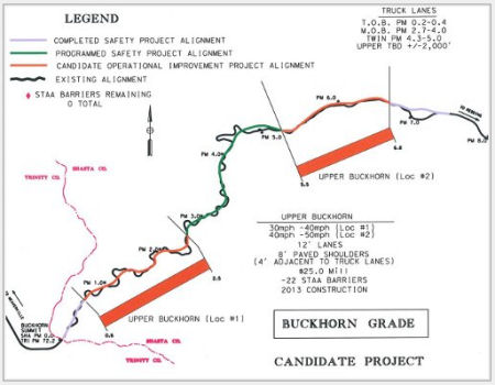 After completion of the Middle Buckhorn project, scheduled for fall of 2012, Caltrans will begin
realigning two hairpin turns in the Twin Gulches section below Middle
Buckhorn. In subsequent years, Caltrans will tackle the relatively mild
lower section and the Upper Buckhorn.
After completion of the Middle Buckhorn project, scheduled for fall of 2012, Caltrans will begin
realigning two hairpin turns in the Twin Gulches section below Middle
Buckhorn. In subsequent years, Caltrans will tackle the relatively mild
lower section and the Upper Buckhorn.
In November 2016, it was reported that the Buckhorn
Grade project was completed, with a completion ceremony that was held
Monday, 11/21/2016. This massive highway project that has interrupted
Trinity County’s Route 299 route to Redding for the past several
years, but was completed ahead of schedule and all remaining clean-up work
should be finished by the end of November. There are also plans for a
roundabout at Lance Gulch Road and Route 299.
(Source: Trinity Journal, 11/16/2016)
Buckhorn Summit - Carr Fire Closures (SHA 0.022)
In August 2018, it was reported that Route 299 has been
closed over Buckhorn since July 23, 2018 when the Carr fire was started by
mechanical failure of a vehicle at Route 299 and Carr Powerhouse Road at
Whiskeytown Lake. Initial assessments identified at least 3,000 hazard
trees to be removed and 60,000 feet of burned guardrail needing
replacement before the road reopens as well as damaged culverts and
pavement that will require long-term repairs. In reality, there are many
more trees affected than 3,000 and damage assessments are still being
done, especially near the summit. In the meantime, discussions between
representatives of Caltrans, Cal Fire and the California Highway Patrol
are occurring daily to reassess and form a plan for reopening the highway.
Delivery of goods and services, medical needs, student transportation and
commuter needs are all part of those discussions. Reopening will likely
happen in stages, starting at the eastern end in Redding to allow
evacuated residents to return to their properties. Progressive, scheduled
openings at certain times of day will also be considered once Cal Fire
deems it safe to reopen the highway to the public. With the highway
closure still in place, the alternate route in or out of Trinity County to
the east is Route 3 to Route 36 into Red Bluff or Cottonwood. From
Weaverville, the trip takes approximately three hours to reach Redding.
Other alternatives are to head west via Route 299 to Arcata, or north up
Route 3 over Scott Mountain to Yreka. The narrow, winding road over Scott
Mountain is not advisable for large RVs or allowed for commercial
vehicles.
(Source: Trinity Journal, 8/8/2018)
In May 2010, the CTC vacated right of way in the city of Redding along Route 299 at 0.08 mile west of Overhill Drive (~ SHA 21.969), consisting of highway right of way no longer needed for State highway purposes.
The CTC considered the route adoption for a highway location along Lake Blvd in the City of Redding from Route 273 at Lake Blvd to I-5 (~ SHA 24.108 to SHA 24.777).
In May 2013, the CTC approved for future consideration of funding a project in Shasta County that will rehabilitate a section of the roadway on Route 299, including replacing drainage facilities, installing new pavement, constructing a center median, widening the Salt Creek Bridge (299 SHA 034.56), and other improvements. The project is programmed in the 2012 State Highway Operation and Protection Program. The total estimated cost is $39,392,000 for capital and support. Construction is estimated to begin in Fiscal Year 2013-14.
In December 2011, the CTC approved $13.3 million to rehabilitate 36.6 lane miles of pavement to extend the service life of the highway and enhance highway safety in and near Montgomery Creek, from 0.3 mile west of Backbone Ridge Road (apx 299 SHA 34.574) to Big Bend Road (299 SHA 60.044).
Curve Improvements E of Ingot (02-Shasta-299 PM 44.3/44.9)
") In March 2019, the CTC amended the following project into the SHOPP:
02-Sha-299 44.3/44.9 PPNO 3742. Proj ID 0219000027. Route 299 Near
Redding, from 1.9 miles west to 1.3 miles west of Du Bois Road. Curve
improvement. Begin const. 6/7/2022. Total est. cost: $11,935,000.
In March 2019, the CTC amended the following project into the SHOPP:
02-Sha-299 44.3/44.9 PPNO 3742. Proj ID 0219000027. Route 299 Near
Redding, from 1.9 miles west to 1.3 miles west of Du Bois Road. Curve
improvement. Begin const. 6/7/2022. Total est. cost: $11,935,000.
(Source: March 2019 CTC Minutes Agenda Item 2.1a.(1) Item 17)
The 2020 SHOPP, approved in May 2020, included the
following Collision Reduction item of interest (carried over from the 2018
SHOPP): 02-Shasta-299 PM 44.3/44.9 PPNO 3742 Proj ID 0219000027 EA 4H930.
Route 299 near Redding, from 1.9 miles west to 1.3 miles west of Du Bois
Road. Curve improvement. Programmed in FY21-22, with construction
scheduled to start in June 2022. Total project cost is $11,935K, with
$7,065K being capital (const and right of way) and $4,870K being support
(engineering, environmental, etc.).
(Source: 2020 Approved SHOPP a/o May 2020)
In June 2020, the CTC approved the following support
allocation for this project: 02-Sha-299 44.3/44.9. PPNO 3742 ProjID
0219000027 EA 4H930. Route 299 near Redding, from 1.9 miles west to 1.3
miles west of Du Bois Road. Curve improvement. Allocation: R/W Support
$310,000.
(Source: June 2020 CTC Agenda, Agenda Item
2.5b.(2a) #5)
In December 2020, the CTC approved the following SHOPP
Support Phase allocation: $1,290,000 for PS&E for 02-Sha-299 PM
44.3/44.9. PPNO 02-3742 ProjID 0219000027 EA 4H930. Route 299 Near
Redding, from 1.9 miles west to 1.3 miles west of Du Bois Road.
Curve improvement.
(Source: December 2020 CTC Agenda, Agenda Item
2.5b.(2a) #5)
In May 2022, the CTC was informed of the following
SHOPP Safety Resolution G-03-10 Delegated Allocation: $10,100,000.
02-Sha-299 44.3/44.9. PPNO 02-3742; ProjID 0219000027; EA 4H930. Route 299
Near Redding, from 1.9 miles west to 1.3 miles west of Du Bois
Road. Outcome/Output: Improve safety by realigning curve,
improving cross slope, widening shoulders, and installing guardrail.
This project will reduce the number and severity of collisions.
Allocation: CON ENG $1,990,000; CONST $6,835,000. Allocation Date:
03/29/2022.
(Source: May 2022 CTC Agenda, Agenda Item 2.5f.(3)
#2)
In September 2010, the CTC vacated right of way in the county of Shasta along Route 299 at 1.0 mile west of Buzzard Roost Road, consisting of highway right of way no longer needed for State highway purposes. (apx 299 SHA 52.439)
Montgomery Creek: Woodhill Dr to Big Bend Road Curve Improvement (02-Sha-299 57.5/59.0)
In May 2022, the CTC amended the following project into
the SHOPP: 02-Sha-299 57.5/59.0. PPNO 02-3763; ProjID 0219000152; EA
0J710. Route 299 Near Montgomery Creek, from 0.1 mile west of Woodhill
Drive to 1.0 mile west of Big Bend Road. Improve curves, widen shoulders,
correct cross slope, and install guardrail. Allocation ($ × 1,000):
PA&ED $1,710; PS&E $1,170; R/W Sup $460; Con Sup $1,740; R/W Cap
$701; Const Cap $6,199; TOTAL $11,980. Begin Const: 4/14/2026.
(Source: May 2022 CTC Agenda, Agenda Item 2.1a.(1a)
#31)
In May 2022, the CTC approved the following
pre-construction phase SHOPP allocation: $1,710,000. 02-Sha-299 57.5/59.0.
PPNO 02-3763; ProjID 0219000152; EA 0J710. Route 299 Near Montgomery
Creek, from 0.1 mile west of Woodhill Drive to 1.0 mile west of Big Bend
Road. Improve curves, widen shoulders, correct cross slope, and install
guardrail. (Concurrent Amendment under SHOPP Amendment 22H-001; May 2022.)
Allocation: FY25-26 PA&ED $1,710,000.
(Source: May 2022 CTC Agenda, Agenda Item 2.5b.(2a) #5)
In February 2006, the CTC considered relinquishment of two segments: (a) right of way in the County of Shasta, between Goose Valley Road (apx 299 SHA 73.283) and Mackinac Street (apx 299 SHA 75.549), consisting of reconstructed and relocated county roads; and (b) right of way in the County of Modoc, at the intersection with County Roads 54, 82 and 83, consisting of reconstructed and relocated county roads..
In August 2011, the CTC approved $2,000,000 in SHOPP funding for Route 299 in Burney at Burney Creek Bridge #06-0062 (apx 299 SHA 74.85). This work would replace one scoured bridge to maintain structural integrity, reduce the risk to lives and properties, and to comply with Bridge Inspection Report recommendation.
In October 2017, the CTC vacated right of way in the county of Shasta along Route 299 between Hat Creek Powerhouse No. 2 Road and Hat Creek Park at Hat Creek (02-Sha-299-PM 83.5/83.9), consisting of highway right of way no longer needed for State highway purposes.
In May 2008, the CTC relinquished right of way in the county of Shasta, at County Road No. 9S060 (Lewis Road, apx 299 SHA 96.12), County Road No. 9S061 (Williams Road, apx 299 SHA 96.701), County Road No. 9S02 (Pittville Road, apx 299 SHA 96.836), County Road No. 9S062 (Lee Ranch Road, apx 299 SHA 97.455), and County Road No. 9S066 (Pittville Totten Road, 299 SHA 99.352), consisting of reconstructed and relocated county roads.
In March 2019, the CTC approved for future consideration of funding a
project is located on various locations along Route 299 and Route 139 in
Lassen and Modoc Counties (02-Las-299, PM 18.5/25.6, 02-Mod-299, PM
0.5/0.5, 1.1/1.8, 02-Mod-139, PM 0.1). This project proposes to reduce the
amount of distressed lane miles by restoring the roadway to a condition of
minimal maintenance for a 20-year design life. This proposed project
addresses the existing poor pavement condition, late stages of
deterioration, and the roadway’s substandard lighting. The project
also proposes widening shoulders, reconstruct driveway approaches, and
updating the Intelligent Transportation System (ITS) elements. This
project is fully funded and programmed in the 2018 SHOPP for approximately
$25.2 million, construction is estimated to begin in 2020. The scope, as
described for the preferred alternative, is consistent with the project
scope programmed by the Commission in the 2018 SHOPP.
(Source: March 2019 CTC Minutes, Agenda Item 2.2c.(1))
Butte Creek Bridges (2-MOD-299 0.51, 1.02)
 In October 2016, the CTC amended the SHOPP as follows: 2-MOD-299 0.51, 1.02 | Route 299 Near
Adin, at Butte Creek Bridge № 03-001 and at Ash Creek Bridge №
03-0002. Replace bridges. During the environmental phase, additional work
was identified due to increased project footprint and a new community
volunteer fire station in the project vicinity. Additional design support
is needed to consider hazardous materials, hydraulics evaluations,
community impact coordination and park impacts. Construction Support has
increased to account for the use of consultants for inspection over two
seasons instead of one. R/W support has increased to cover the cost for
two additional parcels and their environmental mitigation. These changes
add $1,269,000 to the cost of the project. Allocation: $
In October 2016, the CTC amended the SHOPP as follows: 2-MOD-299 0.51, 1.02 | Route 299 Near
Adin, at Butte Creek Bridge № 03-001 and at Ash Creek Bridge №
03-0002. Replace bridges. During the environmental phase, additional work
was identified due to increased project footprint and a new community
volunteer fire station in the project vicinity. Additional design support
is needed to consider hazardous materials, hydraulics evaluations,
community impact coordination and park impacts. Construction Support has
increased to account for the use of consultants for inspection over two
seasons instead of one. R/W support has increased to cover the cost for
two additional parcels and their environmental mitigation. These changes
add $1,269,000 to the cost of the project. Allocation: $47K $131K
(R/W), $5.6MM (C), Support (PA & ED $1.82MM / PS & E $680K
$940K / RW Sup $270K $485K / Con Sup $1.15MM
$1.86MM). FY 17/18.
In May 2017, the CTC approved for future consideration of funding a project located in Modoc County that proposes to replace the Butte Creek Bridge and the Ash Creek Bridge (02-Mod-299, PM 0.5, 1.0). The proposed project will restore long-term reliability and reduce the need for continued maintenance and repairs. This project is programmed in the 2016 SHOPP for $10,836,000 in construction (capital and support) and Right of Way (capital and support). Construction is estimated to begin in Fiscal Year 2018-19. The scope, as described for the preferred alternative, is consistent with the project scope programmed by the Commission in the 2016 State Highway Operation and Protection Program.
In August 2018, it was reported that the CTC allocated
$8.45 million for the project to replace the Butte Creek Bridge on State
Route 299 EB in Adin, and the Ash Creek Bridge on State Route 299 EB in
Modoc county.
(Source: Action News Now, 8/20/2018)
Caldwell Creek Bridge (02-Mod-299 23.1/23.6)
In January 2018, the CTC allocated the following:
$3,019,000. 02-Mod-299 23.1/23.6. Route 299 Near Alturas, from 0.3 mile
west to 0.3 mile east of Caldwell Creek Bridge № 03-0028.
Outcome/Output: Construct a new bridge, realign creek channel to historic
location, upgrade guardrail, and replace conform pavement. (Future
consideration of funding approved under Resolution E-16-67; October 2016).
(Source: CTC Agenda, January 2018, Agenda Item 2.5b(1))
In May 2016, the CTC allocated additional Capital SHOPP funding for Route 299 near Canby, at Caldwell Creek Bridge № 03-0028 (299 MOD 23.34). Replace bridge. Additional design, survey, and environmental clearance effort is necessary to develop a newly identified full detour instead of the original planned stage construction of the bridge. Also, hydraulics studies have since identified the need to raise the profile of the bridge and address greater creek flows. The increase to support costs also reflects an adjustment using current rates. These changes add $725,000 to the cost of the project.
In January 2024, Caltrans released the draft 2024 SHOPP, which contained
the following project: 02-Modoc-299 33.5 /37.5. PPNO 02-3841; ProjID
0221000131; EA 0J730. Route 299 Near Alturas, from 1.8 miles west of
County Road 75 to 0.4 mile east of Crowder Flat Road. Rehabilitate
roadway, improve curves, construct shoulders, concrete barrier, and
guardrail, and rehabilitate drainage systems. Proposed ($ × 1000):
PA&ED: $1,680; PS&E: $1,360; R/W $571; R/W Sup $530; Con $14,450;
Con Sup: $2,040; Total: $20,631. Begin Con: 4/4/2028.
(Source: 2024 Draft SHOPP v4.0, 1/31/2024)
Alturas Route 299 Improvements / Canby Highway Advisory Radio Projects (~ MOD 39.878)
In December 2012, the CTC received a request to amend the 2012 STIP to delete the Alturas Route 299 Widening project (PPNO 3368) (apx 299 MOD 39.878) and the Route 299/Route 139 Canby Highway Advisory Radio project (PPNO 3382) (apx 299 MOD 21.124) in Modoc County. MCTC has determined that the two STIP projects are no longer a priority in the region due to a continued economic downturn, slow population increase and business demise. It was deferred to the January 2013 meeting, and deferred again to the March 2013 when it was again... deferred. The original need for the project was first identified by the MCTC in mid 1990’s to improve traveler safety and reduce speeds approaching the city. As this segment of two-lane highway enters the City of Alturas, traffic flow can become congested due to the turning movements of vehicles. Business and residential areas exist along this mile long reach where traffic interruptions and queuing occur. Future growth was anticipated, further contributing to congestion and the potential for increased accidents. Shoulder widths vary from 1 foot to 4 feet wide, and mobility of bicycles and pedestrians is a challenge. A project was initiated and programmed in the 1998 and 2000 STIP to address the need by adding a continuous left turn lane, wider shoulders and drainage improvements. Project development work continued over the years until MCTC alerted the Department that local priorities and project support had changed. The unmet need remained until MCTC requested that the Commission reprogram the project in the 2008 STIP, with the Environmental phase to begin in 2011. In a collaborative effort, the Department and MCTC developed a project charter that identified the specific needs of the project; including wider shoulders and crosswalks along with flashing beacons to improve pedestrian mobility and safety, speed radar feedback signs for traffic calming, installation of concrete gutters, culverts and paved areas for drainage improvements. The continuous left turn lane was deleted from the project. However, in August 2012, just after the Department completed the environmental phase, MCTC requested the project be terminated for a second time due to changed local priorities and support for the project. The Department strongly supports the continued development of this project for a number of reasons, including safety, bicyclist and pedestrian support, traffic calming, and congestion issues.
In May 2013, the CTC received notice that Caltrans, the City of Alturas and the Modoc County Transportation Commission (MCTC) propose to amend the 2012 STIP to reduce the scope of the Alturas Route 299 Improvements project (PPNO 3368); decreasing the programmed Regional Improvement Program (RIP) funding by $1,010,000, from $3,244,000 to $2,234,000, and removing $1,052,000 of programmed RIP Transportation Enhancement (TE) funds. It is also proposed to program $1,173,000 in RIP funding for a new pedestrian improvements project (PPNO 2534) along the Alturas Central Business District in Modoc County. Specifically, in a collaborative effort to identify the specific needs of this project, the department and MCTC have negotiated an agreement to reduce the scope of improvements along Route 299. It is proposed to remove lower priority TE elements from the scope of work, while improving the shoulder width and drainage systems for bicyclists and pedestrians. Three new radar feedback signs for traffic calming will also be installed. This scope reduction will allow $2,062,000 to be returned to Modoc County’s regional share balance. The design work necessary for revising the scope will delay construction from FY 2013-14 to FY 2014-15. MCTC proposes to program a new pedestrian improvement project, the Alturas Central Business District project (PPNO 2534) with $1,173,000 from Modoc County’s regional share balance. The project proposes to improve existing facilities adjacent to surface streets along the central business district of the city of Alturas. This project is higher priority for the county and includes TE eligible elements that will enhance pedestrian mobility in the downtown area.
In August 2018, the CTC approved $4,074,000 in SHOPP funding for Modoc
02-Mod-299 51.9/52.5: Route 299: Near Cedarville, from 0.6 mile west of
Cedar Pass Ski Tow Road to Cedar Pass Ski Tow Road. Outcome/Output:
Improve safety by realigning roadway curves, widening lane and shoulder
widths, improving roadside clear recovery zone and drainage, and
installing a drapery system to prevent rockfall. This project will reduce
the number and severity of collisions.
(Source: August 2018 CTC Agenda Item 2.5f.(3) Item
4)
 Naming
 The segment between US 101 and Redding (HUM
0.000 to SHA 24.082) is named the "Trinity Scenic Byway". It was
named by Assembly Concurrent Resolution 126, Chapter 131, in 1992.
The segment between US 101 and Redding (HUM
0.000 to SHA 24.082) is named the "Trinity Scenic Byway". It was
named by Assembly Concurrent Resolution 126, Chapter 131, in 1992.
(Image source: AARoads)
The portion between the Shasta county line and the Modoc county line (SHA 0.000 to SHA 99.248) is named the "Lassen State Highway". It was named by Resolution Chapter 498 in 1911.
 Thompson") The portion of Route 299 located between SHA 83.03 and SHA 84.00
in the County of Shasta is named the "Robert “Bob”
Thompson Memorial Highway". It was named in memory of Robert
“Bob” Thompson,a fourth-generation resident of Shasta County
and the grandson of ranchers who came to Eastern Shasta County in the
1930s. Robert Thompson’s background in farming and ranching began as
a toddler on the Hat Creek Hereford Ranch and, as a young person, he
became active in 4-H and the Future Farmers of America (FFA). Robert
Thompson attended a two-room schoolhouse for five years in elementary
school, was active in student government, athletics, and FFA in high
school, and graduated from Fall River High School in 1967. After high
school, Robert Thompson attended California State University, Chico where
he met his wife of 49 years, Alice Hutchings. While at Chico State, Robert
and Alice Thompson’s only son, Perry, was born and Robert Thompson
worked several jobs to put himself and his wife through school without
incurring large student loan debt. When Robert, Alice, and Perry returned
home after college, Robert continued his involvement in agriculture by
helping to run the family ranch while Alice began her 37-year teaching
career. While Robert Thompson loved working with cattle, farming the land,
and being involved in numerous agricultural organizations, he turned his
focus to construction to “pay the bills”. With guidance and
support from his father, Robert Thompson and his brother-in-law Howard
Lakey became founders and coowners of Hat Creek Construction. Robert
Thompson and Howard Lakey began operating Hat Creek Construction from
humble beginnings with a used Toyota pickup truck and several home remodel
projects. As Hat Creek Construction grew, the company began building homes
and cabins in the Eagle Lake area and soon the company expanded into road
building, hydro construction, and general engineering work. Today Hat
Creek Construction is a dominant force in the construction industry and an
area leader in asphalt, concrete, and aggregate delivery and placement.
Robert Thompson was able to consult and advise until the time of his
passing and witnessed his beloved company and team complete its largest
season ever, while proudly providing jobs for 125 local employees. Named
by Assembly Concurrent Resolution (ACR) 202, Res. Chapter 151, 8/17/2018.
The portion of Route 299 located between SHA 83.03 and SHA 84.00
in the County of Shasta is named the "Robert “Bob”
Thompson Memorial Highway". It was named in memory of Robert
“Bob” Thompson,a fourth-generation resident of Shasta County
and the grandson of ranchers who came to Eastern Shasta County in the
1930s. Robert Thompson’s background in farming and ranching began as
a toddler on the Hat Creek Hereford Ranch and, as a young person, he
became active in 4-H and the Future Farmers of America (FFA). Robert
Thompson attended a two-room schoolhouse for five years in elementary
school, was active in student government, athletics, and FFA in high
school, and graduated from Fall River High School in 1967. After high
school, Robert Thompson attended California State University, Chico where
he met his wife of 49 years, Alice Hutchings. While at Chico State, Robert
and Alice Thompson’s only son, Perry, was born and Robert Thompson
worked several jobs to put himself and his wife through school without
incurring large student loan debt. When Robert, Alice, and Perry returned
home after college, Robert continued his involvement in agriculture by
helping to run the family ranch while Alice began her 37-year teaching
career. While Robert Thompson loved working with cattle, farming the land,
and being involved in numerous agricultural organizations, he turned his
focus to construction to “pay the bills”. With guidance and
support from his father, Robert Thompson and his brother-in-law Howard
Lakey became founders and coowners of Hat Creek Construction. Robert
Thompson and Howard Lakey began operating Hat Creek Construction from
humble beginnings with a used Toyota pickup truck and several home remodel
projects. As Hat Creek Construction grew, the company began building homes
and cabins in the Eagle Lake area and soon the company expanded into road
building, hydro construction, and general engineering work. Today Hat
Creek Construction is a dominant force in the construction industry and an
area leader in asphalt, concrete, and aggregate delivery and placement.
Robert Thompson was able to consult and advise until the time of his
passing and witnessed his beloved company and team complete its largest
season ever, while proudly providing jobs for 125 local employees. Named
by Assembly Concurrent Resolution (ACR) 202, Res. Chapter 151, 8/17/2018.
(Image source: Hat Creek Construction)
 Named Structures
Bridge 04-0036, over the Mad River in Humboldt County (HUM R001.55), is named the "Thomas L. Devore Memorial Bridge". It was built in 1965, and was named by Senate Concurrent Resolution 94, Chapter 229, in the same year. Thomas L. Devore, a Blue Lake native, died Feb. 1, 1943, when the USS DeHaven, a battleship, sank during its patrol of the Guadalcanal shoreline near the Solomon Islands, at the hands of Japanese warplanes. According to Ernest A. Herr’s description of the USS DeHaven’s demise, “The Last Day of the USS DeHaven,” a combination of factors led to disaster — two engines shut down for maintenance and the inability to quickly determine whether the approaching planes were friend or foe. The 376-foot long ship was escorting landing craft when it was struck by three bombs and damaged by a near miss. The massive warship had only been commissioned 133 days when it sank and took Devore with it.
Bridge 04-0042, at Redwood Creek in Humboldt County (HUM R022.33), is named the "Don O. O'Kane Memorial Bridge". It was built in 1965, and was named by Senate Concurrent Resolution 58, Chapter 178 in 1970. Don Hunter O'Kane was the publisher of the Humboldt Standard newspaper from 1935 to 1946 and an avid supporter of the development of the state highway system.
Bridge 04-050, 8 mi E of Willow Creek over the south fork of the Trinity River in Humboldt County (HUM 042.95), is named the "Hlel-Din Memorial Bridge". It was built in 1988, and named by Assembly Concurrent Resolution 158, Chapter 112, in the same year. The Native American village of Hlel-Din was an important gathering place for many tribes to exchange ideas and goods and to seek marriage partners, until it's destruction in the 1850's.
Bridge 05-0081, over the Trinity River in Trinity County (TRI R003.16), is named the "Raymond A. Nachand Memorial Bridge". Raymond A. Nachand was born in Alton, Illinois in August 1918, and subsequently moved to Burnt Ranch, California in 1937 where he graduated from Hoopa High School in 1938. Mr. Nachand held numerous jobs in the aeronautical industry during and after World War II in southern California. Mr. Nachand subsequently returned to Burnt Ranch where at various times he worked for Moss Mill Lumber Company, drove the school bus from Burnt Ranch to Weaverville, and worked for the former California Division of Highways (now the Department of Transportation) for 22 years, retiring in 1973. Mr. Nachand volunteered for many worthwhile causes in his community and, in this connection, held the positions of firefighter, church elder, hospice worker, and friend to all. In 1976, Mr. Nachand and his wife, JoAnn, opened their richly endowed Ironside Museum in Hawkins Bar to "preserve our heritage and historical interest". The museum continues to be visited by persons who come to Hawkins Bar from around the world. Mr. Nachand passed away on May 17, 1997, at the age of 78 years at his home after several years of illness. Named by Assembly Concurrent Resolution 176, Chapter 160 in 1998.
Bridge 05-0082 over the Trinity River, 3.5 mi E of the Humboldt county line in Trinity County (TRI R003.44), is named the "Charles William Carpenter Memorial Bridge". It was built in 1989, and was named by Senate Concurrent Resolution 25, Chapter 84, the same year. Trinity County deputy Sheriff Charles William Carpenter was killed in the line of duty on the morning of July 13, 1928, while attempting to arrest three robbery suspects who had just robbed a store in Willow Creek, California. A shootout ensued and Deputy Carpenter and one of the suspects were killed. The other two suspects fled but one was later apprehended. The other suspect was captured five years later after he robbed a post office in New York City. He was returned to California and sentenced to life in prison on July 7, 1933.
 Bridge 05-0006 over the Trinity River in Trinity County (TRI 013.87) is named the "William D.
Abarr Memorial Bridge". William D. Abarr, a Caltrans heavy equipment
operator, died January 25, 1983, in a massive mudslide on Route 299 in
Trinity County. At the time of his death he was operating earth moving
equipment that was clearing a slide from Route 299 when another mudslide
swept his equipment off the highway. Mr Abarr joined the Department of
Highways (Caltrans) in March 1973 after working for the Trinity County
Department of Public Works for 13 years. He was a conscientious employee
who would go the extra mile to do a good job, and was responsive to
emergency calls to sand icy areas to remove rocks or slides and to do
other needed emergency work. It was named by Assembly Concurrent
Resolution 134, Chapter 126, in 1984.
Bridge 05-0006 over the Trinity River in Trinity County (TRI 013.87) is named the "William D.
Abarr Memorial Bridge". William D. Abarr, a Caltrans heavy equipment
operator, died January 25, 1983, in a massive mudslide on Route 299 in
Trinity County. At the time of his death he was operating earth moving
equipment that was clearing a slide from Route 299 when another mudslide
swept his equipment off the highway. Mr Abarr joined the Department of
Highways (Caltrans) in March 1973 after working for the Trinity County
Department of Public Works for 13 years. He was a conscientious employee
who would go the extra mile to do a good job, and was responsive to
emergency calls to sand icy areas to remove rocks or slides and to do
other needed emergency work. It was named by Assembly Concurrent
Resolution 134, Chapter 126, in 1984.
(Image source: Find a Grave)
 The Burney Creek Bridge (Bridge 06-0062, SHA 074.85) on Main Street along
Route 299, in the unincorporated area of Burney, County of Shasta, is
named the "Deputy Kenneth Fredrick Perrigo Memorial Bridge". It
was named in memory of Deputy Kenneth Fredrick Perrigo, who was born in
1958. Deputy Perrigo first worked for the Shasta County Sheriff's Office
as a civilian cook at the main jail facility in 1981. Prior to his
appointment as a Deputy Sheriff, Kenneth Perrigo served our country as a
member of the United States Coast Guard. Deputy Perrigo was hired as a
full-time Deputy Sheriff in1982 and assigned to the Burney Patrol
Division. Deputy Perrigo was one of the charter members of the Shasta
County Sheriff's Office Special Weapons and Tactics (SWAT) team. Deputy
Perrigo was a board member of the Shasta CountyPeace Officers Association.
Deputy Perrigo was Scoutmaster of Boy Scout Troop 216 inFall River Mills.
On Monday, October 21, 1991, Deputy Perrigo arrested two suspects for
being intoxicated in public, and was transporting themto the Shasta County
main jail in Redding, California, when the suspects shot him in the back
and head several times using Deputy Perrigo's secondary service weapon,
and he died in the line of duty that day. The suspects were subsequently
apprehended without incident, following an almost five-day pursuit, deemed
the largest and longest in the County of Shasta's history. President
George H. W. Bush telephoned Deputy Perrigo's wife, Debra, to express his
condolences. Named by Senate Concurrent Resolution 78, Resolution Chapter
88, on August 24, 2012.
The Burney Creek Bridge (Bridge 06-0062, SHA 074.85) on Main Street along
Route 299, in the unincorporated area of Burney, County of Shasta, is
named the "Deputy Kenneth Fredrick Perrigo Memorial Bridge". It
was named in memory of Deputy Kenneth Fredrick Perrigo, who was born in
1958. Deputy Perrigo first worked for the Shasta County Sheriff's Office
as a civilian cook at the main jail facility in 1981. Prior to his
appointment as a Deputy Sheriff, Kenneth Perrigo served our country as a
member of the United States Coast Guard. Deputy Perrigo was hired as a
full-time Deputy Sheriff in1982 and assigned to the Burney Patrol
Division. Deputy Perrigo was one of the charter members of the Shasta
County Sheriff's Office Special Weapons and Tactics (SWAT) team. Deputy
Perrigo was a board member of the Shasta CountyPeace Officers Association.
Deputy Perrigo was Scoutmaster of Boy Scout Troop 216 inFall River Mills.
On Monday, October 21, 1991, Deputy Perrigo arrested two suspects for
being intoxicated in public, and was transporting themto the Shasta County
main jail in Redding, California, when the suspects shot him in the back
and head several times using Deputy Perrigo's secondary service weapon,
and he died in the line of duty that day. The suspects were subsequently
apprehended without incident, following an almost five-day pursuit, deemed
the largest and longest in the County of Shasta's history. President
George H. W. Bush telephoned Deputy Perrigo's wife, Debra, to express his
condolences. Named by Senate Concurrent Resolution 78, Resolution Chapter
88, on August 24, 2012.
(Image source: Shasta County Sheriff on FB)
Cedar Pass is named for the the town of Cedarville, which in turn was named by J. H. Bonner in 1867 after his
hometown in Ohio. Water west of the pass uses the Pitt River to get to the
Sacramento and thence to Redding. Water east of the pass flows into the
Great Basin.
(Sources: Bill Sanford "Getting out of the Central
Valley: Highway passes to the east" (emailed draft 10/1/2010))
This route also has the following Safety Roadside Rest Areas:
 Francis B. Mathews Memorial Rest Area (Salyer), in Trinity County, 3 mi E of Salyer (~ TRI 3.661). Named in memory of Francis B. Mathews. Mr. Mathews
was a well respected attorney and community leader in Trinity and
Humboldt Counties for over 50 years. He was also a a real estate
developer, logger, builder, fishing boat and marina owner. Although he
was known largely for his representation of timber, logging, and sawmill
companies, his pro bono services and dedication to the citizens of
Trinity and Humboldt Counties and the Hoopa and Yurok Indian tribes were
well known throughout the region. His reputation for integrity and his
dedication to community endeavors were unsurpassed. As an Eagle Scout in
the Boy Scouts of America, Francis B. Mathews sat on the scout council
and was an active fundraiser and contributor to the scouting programs in
Trinity and Humboldt Counties. He served in the Army Air Corps during
World War II. He was instrumental in the founding of Trinity Village at
Hawkins Bar in Trinity County, a large planned community built upon
reclaimed land. Lastly he was a naturalist and lifetime birdwatcher who
donated his entire bird book collection of over 3,000 books to
California State University, Humboldt. Named by Senate Concurrent
Resolution 38, Chapter 110, September 17, 2001.
Francis B. Mathews Memorial Rest Area (Salyer), in Trinity County, 3 mi E of Salyer (~ TRI 3.661). Named in memory of Francis B. Mathews. Mr. Mathews
was a well respected attorney and community leader in Trinity and
Humboldt Counties for over 50 years. He was also a a real estate
developer, logger, builder, fishing boat and marina owner. Although he
was known largely for his representation of timber, logging, and sawmill
companies, his pro bono services and dedication to the citizens of
Trinity and Humboldt Counties and the Hoopa and Yurok Indian tribes were
well known throughout the region. His reputation for integrity and his
dedication to community endeavors were unsurpassed. As an Eagle Scout in
the Boy Scouts of America, Francis B. Mathews sat on the scout council
and was an active fundraiser and contributor to the scouting programs in
Trinity and Humboldt Counties. He served in the Army Air Corps during
World War II. He was instrumental in the founding of Trinity Village at
Hawkins Bar in Trinity County, a large planned community built upon
reclaimed land. Lastly he was a naturalist and lifetime birdwatcher who
donated his entire bird book collection of over 3,000 books to
California State University, Humboldt. Named by Senate Concurrent
Resolution 38, Chapter 110, September 17, 2001.  Moon Lim Lee (Weaverville), in Trinity County, 5 mi E of Weaverville (~ TRI 56.949). Named by Assembly
Concurrent Resolution 88, Chapter 16, in 1986. It was named in honor of
Moon Lim Lee by the State of California Transportation Department. Moon
Lim Lee's name comes from the activities of his father, Lim Sue Kin. The
father operated a Weaverville restaurant in the late 1800s with the
name, Sam Lee. Located on Main Street, its name means three fold
prosperity in a Cantonese dialect. Lim Sue Kin became widely know as Sam
Lee, Thus, the family name changed in a manner not uncommon for that
period. Moon Lim Lee was a prominent businessman and served on many
boards and committees that worked for the betterment of of Trinity
County. He was appointed by Governor Ronald Reagan to the California
Highway Commission in 1967 and served as a commissioner for eight years.
His effort in saving Won Lim Miao helped produce Weaverville Joss House
State Park.
Moon Lim Lee (Weaverville), in Trinity County, 5 mi E of Weaverville (~ TRI 56.949). Named by Assembly
Concurrent Resolution 88, Chapter 16, in 1986. It was named in honor of
Moon Lim Lee by the State of California Transportation Department. Moon
Lim Lee's name comes from the activities of his father, Lim Sue Kin. The
father operated a Weaverville restaurant in the late 1800s with the
name, Sam Lee. Located on Main Street, its name means three fold
prosperity in a Cantonese dialect. Lim Sue Kin became widely know as Sam
Lee, Thus, the family name changed in a manner not uncommon for that
period. Moon Lim Lee was a prominent businessman and served on many
boards and committees that worked for the betterment of of Trinity
County. He was appointed by Governor Ronald Reagan to the California
Highway Commission in 1967 and served as a commissioner for eight years.
His effort in saving Won Lim Miao helped produce Weaverville Joss House
State Park.  Scenic Route
[SHC 263.8] From Route 101 near Arcata to Route 96 near Willow Creek; and from Route 3 near Weaverville to Route 5 near Redding.
 Freeway
[SHC 253.8] Entire portion. Added to the Freeway and Expressway system in 1959.
Scenic Route Classified Landcaped Freeway
The following segments are designated as Classified Landscaped Freeway:
| County | Route | Starting PM | Ending PM |
| Humboldt | 299 | 0.00 | 0.10 |
 From Route 395 near Alturas to the Nevada state line via Cedarville.
Post 1964 Signage HistoryThis segment remains unchanged from its 1963 definition.
Pre 1964 Signage History1915 Legislative Chapter 765 authorized a survey to extend LRN 28 from Surprise Valley in Modoc County to the Nevada State Line. LRN 28 was formally funded east of Alturas to the Nevada State Line via 1921 Legislative Chapter 888:
"for the survey, plans and estimates and for the construction of the highway from the town of Alturas in Modoc County to the Nevada-California state line by the most direct and practical route via Cedarville in connecting with the proposed Nevada state highway (Nevada State Route 8A)..."
Although the road itself looks to have been a state route (part of LRN 28) since 1935, there is no evidence that this was signed. The formal designation of US 299 ended at US 395. LRN 28 connected to NV 8A, and appears to have been unsigned until the 1964 renumbering.
StatusThe following project was included in the final adopted 2018 SHOPP in March 2018: PPNO 3607. 02-Modoc-299 51.9/52.5. On Route 299 Near Cedarville, from 0.6 mile west of Cedar Pass Ski Tow Road to Cedar Pass Ski Tow Road. Curve improvement. Begin Con: 9/18/2018. Total Project Cost: $5,419K.
 Exit Information
 Other WWW Links
 Statistics
Overall statistics for Route 299:
 Interregional Route
© 1996-2020 Daniel P. Faigin.
Maintained by: Daniel P. Faigin
<webmaster@cahighways.org>.
 Route 296
 Route 305