
 California Highways:
Click here for a key to the symbols used. An explanation of acronyms may be found at the bottom of the page.
 Routing
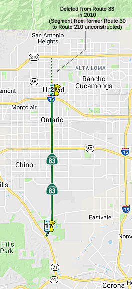 From Route 71
to Route 10 near the City of Upland.
From Route 71
to Route 10 near the City of Upland.
(1) Upon a determination by the commission that it is in the best interests of the state to do so, the commission may, upon terms and conditions approved by it, relinquish to the City of Chino all or a portion of Route 83 within its jurisdiction, if the department and the city enter into an agreement providing for that relinquishment.
(2) The following conditions apply upon relinquishment:
The entirety of Route 83 relinquished under this section is ineligible for future adoption under Section 81.
 Post 1964 Signage History
In 1963, this route was defined as "Route 71 to Route 30 near Upland.".
In 1999, this was changed to end at Route 210 instead of Route 30, reflecting the 1998 renaming of Route 30 (AB 1650, Ch 724, 10/10/99). This had the net effect of moving the terminus of Route 83 from 19th Street in Upland (Route 30) to the new freeway (Route 210). However, the portion between former Route 30 and Route 210 is unconstructed—according to the Caltrans postmile log, Route 83 ends at Postmile 14.193, which is at the former Route 30 (19th St.).
With respect to offramps in Upland, Ali Pezeshkpour writes:
Upland chose to place on and off-ramps for the new freeway at Mountain Avenue and Campus Avenue (Mountain Ave for access to Mt. Baldy, Campus for access to the 1,000 new homes and mall in being built in Upland). Then, around 1998-99, Upland chose to relocate Campus Ave. and create a new alignment about .5 miles to the east, which is the distance between the major north-south arterials of the city of Upland. This means that Mtn. Ave and Euclid Ave are 1 mile apart, and Euclid and the new Campus are 1 mile apart. Thus, the possibilty of adding ramps to Euclid in the future would be left open. Also, in an unusual note, posts were placed along Euclid to prepare the street for new shields and signs for freeway entrances, but were later removed. Sound-wall construction had gaps in the walls around Euclid left until about 6 months ago when they were filled in, but the recently constructed power lines paralleling the freeway and crossing Euclid were done in a way that they would go around any ramps that could be built. The retaining wall around Euclid was also constructed in an odd manor, as if to suggest that they could be removed when the time came to place ramps at Euclid. Grading was also done on curbs where ramps could be added about 6 months ago.
In 2006, AB 3030 and SB 246, Chapter 248, 8/26/2006 permitted relinquishment in Upland: (1) Notwithstanding subdivision (a), the commission may relinquish to the City of Upland the portion of Route 83 that is located within the city limits or the sphere of influence of the city, upon terms and conditions that the commission finds to be in the best interests of the state. (2) A relinquishment under this subdivision shall become effective immediately following the recordation by the county recorder of the relinquishment resolution containing the commission's approval of the terms and conditions of the relinquishment. (3) On and after the effective date of the relinquishment, both of the following shall occur: (A) The portion of Route 83 relinquished under this subdivision shall cease to be a state highway. (B) The portion of Route 83 relinquished under this subdivision may not be considered for future adoption under Section 81. (c) The city shall ensure the continuity of traffic flow on the relinquished portion of Route 83, including any traffic signal progression. (d) For relinquished portions of Route 83, the city shall maintain signs directing motorists to the continuation of Route 83. [Added by SB 246 (Chapter 248, 8/26/2006)]. This right of way was relinquished in June 2008.
In 2010, AB 1318, Chapter 421, 9/29/10, changed the terminus from Route 210 near Upland to Route 10 near Upland.
In 2021, AB 744, Chapter 198, 9/22/2021, changed the terminus to “…Route 10 near the city of Upland.” and added section (c). Notable in section (c) is the authorization to “relinquish to the City of Ontario all or a portion of Route 83 within its jurisdiction, if the department and the city enter into an agreement providing for that relinquishment.” Originally they intended to change the definition to "…from Route 71 to Merrill Avenue and includes the southbound portion between Merrill Avenue and Riverside Drive within the City of Chino", but that change was amended away. The means that the current routing could (and probably will) be relinquished to the city, but a new routing could (but is unlikely to) be defined until the legislative definition is changed. The Senate analysis noted: “This part of State Route 83 passes through a commercial area with a large center median. The City wants to install storm drains, invest in median beautification, improve sidewalks, create active transportation paths, and create more transit oriented development.” and the author noted “The City of Ontario has undergone significant changes as it emerges to be a regional transit hub and sustainable live-work city. The State should support the City as it continues its expansive redevelopment and new investment in building a strong central city core.”
In 2023, the portion in Ontario was relinquished.
In 2023, AB 250, Chapter 516, 10/8/2023, authorized relinquishment in the City of Chino by adding section (d) and moving what had been (c)(2)(C) to item e:
(1) Upon a determination by the commission that it is in the best interests of the state to do so, the commission may, upon terms and conditions approved by it, relinquish to the City of Chino all or a portion of Route 83 within its jurisdiction, if the department and the city enter into an agreement providing for that relinquishment.
(2) The following conditions apply upon relinquishment:
The entirety of Route 83 relinquished under this section is ineligible for future adoption under Section 81.
Note that it appears that the accumulation of the relinquishment authorizations will have relinquished all of the authorized routings for Route 83, leaving it a paper (legislatively defined) routing with no surface routing.
 Pre 1964 Signage History
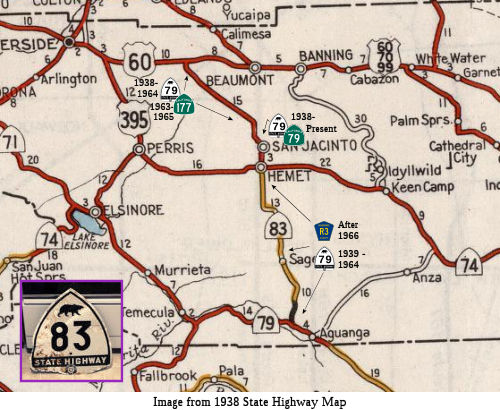 Post 1964 Route 83 was LRN 192, defined in 1933 as
"LRN 77 via Euclid Avenue to LRN 190 in Upland". It was not signed as part
of the initial set of signed routes in 1934. LRN 192 ran from LRN 190/Olive Street in Upland to Route 71/LRN 77 at Pine Avenue.
Post 1964 Route 83 was LRN 192, defined in 1933 as
"LRN 77 via Euclid Avenue to LRN 190 in Upland". It was not signed as part
of the initial set of signed routes in 1934. LRN 192 ran from LRN 190/Olive Street in Upland to Route 71/LRN 77 at Pine Avenue.
In 1959, the Route 71/LRN 77 Corona Freeway Interchange with LRN 192 was
completed. The project included 5.3 miles of the Corona Freeway to
Merrill Avenue as a Super Two Freeway. In 1959, the definition of
LRN 192 was simplified to "LRN 77 to LRN 190 in Upland."
(Source: Gribblenation Blog (Tom Fearer), "California State Route 83", June 2022)
 The original Sign Route 83 was aligned on LRN 194 between Route 79 near Aguanga north to US 60 in the Moreno Valley Badlands. Route 83 was
not one of the original run of Signed State Routes which were announced in
a 1934 Department of Public Works Guide. LRN 194 was added to the State
Highway System in 1933. LRN 194 as originally defined beginning at the
Descanso-Temecula Road and ending to the north at LRN 19, which was US 60
at the intersection of what is now Gillman Springs Road and Jack Rabbit
Trail. When US 60 was extended into California in 1932 it utilized Jack
Rabbit Trail and Gillman Springs Road west from Beaumont to cross the
Moreno Valley Badlands. In 1934 US 70 was co-signed with US 60 over Jack
Rabbit Trail and Gillman Springs Road in the Moreno Valley Badlands. By
1936 US 60 had been moved to a new alignment through the Moreno Valley
Badlands north of Jack Rabbit Trail and Gillman Springs Road. US 70
subsequently was shifted to a co-signed route to the north on US 99.
Subsequently Jack Rabbit Trail was relinquished as a State Highway and
Gillman Springs Road became an extension of LRN 194. By 1938 State
Maintenance of LRN 194 was complete and the route appears signed as Route 83 for the first time on 1938 Division of Highways Map of California.
However, the designation did not last long. By 1940 the route is shown to
be signed as a realignment of Route 79. The new alignment of Route 79 is
shown replacing Route 83 on the 1940 Division of Highways Map of
California. Route 71 is shown replacing what was Route 79 west from the
south terminus of Route 83 towards Temecula. Still, on a map of the San
Bernardino area from 1941, Route 83 was signed along Gilman Springs Road
from US 60 to Route 79. During the 1964 State Highway Renumbering Route 79
was shifted to a new alignment north of Sanderson Avenue via Lamb Canyon
Road to Beaumont. (1938-1940) Route 83/Route 79 on Gillman Springs Road
subsequently became the first Route 177.
The original Sign Route 83 was aligned on LRN 194 between Route 79 near Aguanga north to US 60 in the Moreno Valley Badlands. Route 83 was
not one of the original run of Signed State Routes which were announced in
a 1934 Department of Public Works Guide. LRN 194 was added to the State
Highway System in 1933. LRN 194 as originally defined beginning at the
Descanso-Temecula Road and ending to the north at LRN 19, which was US 60
at the intersection of what is now Gillman Springs Road and Jack Rabbit
Trail. When US 60 was extended into California in 1932 it utilized Jack
Rabbit Trail and Gillman Springs Road west from Beaumont to cross the
Moreno Valley Badlands. In 1934 US 70 was co-signed with US 60 over Jack
Rabbit Trail and Gillman Springs Road in the Moreno Valley Badlands. By
1936 US 60 had been moved to a new alignment through the Moreno Valley
Badlands north of Jack Rabbit Trail and Gillman Springs Road. US 70
subsequently was shifted to a co-signed route to the north on US 99.
Subsequently Jack Rabbit Trail was relinquished as a State Highway and
Gillman Springs Road became an extension of LRN 194. By 1938 State
Maintenance of LRN 194 was complete and the route appears signed as Route 83 for the first time on 1938 Division of Highways Map of California.
However, the designation did not last long. By 1940 the route is shown to
be signed as a realignment of Route 79. The new alignment of Route 79 is
shown replacing Route 83 on the 1940 Division of Highways Map of
California. Route 71 is shown replacing what was Route 79 west from the
south terminus of Route 83 towards Temecula. Still, on a map of the San
Bernardino area from 1941, Route 83 was signed along Gilman Springs Road
from US 60 to Route 79. During the 1964 State Highway Renumbering Route 79
was shifted to a new alignment north of Sanderson Avenue via Lamb Canyon
Road to Beaumont. (1938-1940) Route 83/Route 79 on Gillman Springs Road
subsequently became the first Route 177.
(Sources: Ali Pezeshkpour, Gribblenation Blog The mystery of the original California State Route 83)
So why was Route 83 renumbered into Route 79, vs. staying Route 83.
According to Scott Parker on AARoads: The Route 79-for-Route 83 switch
happened only a few years after US 395 was commissioned in CA. Its
original San Diego-Riverside path via Vista, Fallbrook, and Lake Elsinore
was indeed convoluted. Much of that, part of LRN 77, was originally slated
to be Route 71 prior to US 395 entering the picture. But once US 395
happened, it was apparently decided to make Route 79 an eastern parallel
alternative to that route, so it subsumed old Route 83, with Route 71
serving as a northern "feeder" for Route 79, funneling traffic in from
east of L.A. all the way to the Inland Empire. Temecula was nothing more
than a rural junction point until substantial development began in the
mid-60's; the Division of Highways thought it more important to locate
Hemet, at the time the largest town southeast of Riverside, along this
alternate N-S corridor than to serve the smaller town also served by US 395 and Route 71.
(Source: Scott Parker on AARoads, "Re: CA 79", 10/30/2019)
It does not appear that a route was signed as Route 83 between 1941(ish) and 1964.
 Status
There may be some plans to upgrade a portion of this route. According to "LA Freeway Enthusiast" in October 2002, there was an article in the Inland Valley Daily Bulletin about a plan to upgrade Route 83 (Euclid Ave) from Route 71 in Frontera to Route 60 in Ontario (~ SBD R0.059 to SBD 7.04); the plan called for a widening of the narrow section by the Chino state prison and improvements within the Ontario section south of Route 60.
Route 83 Relinquishment in Ontario: Merrill Ave to Route 60 (SBD 3.92/7.15) and Route 60 to Route 10 (SBD 7.2/11.1)
In March 2023, the CTC approved the following amendment
to the 2022 SHOPP: 08-SBd-83 7.6/11.1 7.2/11.1.
PPNO 08-3011G; ProjID 0818000013; EA 1J280. Route 83 In Ontario, from south
of Cedar Street Route 60 to Route 10; also from
Merrill Avenue to Route 60 (PM 3.92/7.15). Rehabilitate
pavement and upgrade facilities to Americans with Disabilities Act (ADA)
standards. Financial Contribution Only (FCO) to City of
Ontario to relinquish roadway. Concurrent COS allocation under
Resolution FP-22-57; March 2023. Note: This project will be a
Financial Contribution Only (FCO) for construction capital to the City of
Ontario to relinquish this route. Update postmiles, description,
performance, and program code to reflect this change. Allocation ($ ×
1,000): PA&ED $3,342 ; PS&E $5,553; R/W Sup $1,772; Con Sup $5,797
$0; R/W Cap $646 $0; Const Cap $23,449;
TOTAL $40,559 $34,116. FY23-24
(Source: March 2023 CTC Agenda, Agenda Item 2.1a.(1e) #1)
In March 2023, the CTC approved the following
pre-construction project support phase SHOPP (2a) or SB1 (2b) allocation:
$1,200,000. 08-SBd-83 7.2/11.1. PPNO 08-3011G; ProjID 0818000013; EA
1J280. Route 83 In Ontario, from Route 60 to Route 10; also from Merrill
Avenue to Route 60 (PM 3.92/7.15). Financial Contribution Only (FCO)
to City of Ontario to relinquish roadway. (Categorically Exempt)
Concurrent Amendment under SHOPP Amendment 22H-007; March 2023. PS&E
$5,553,000 (Programmed) $1,150,000 (Allocated); R/W Sup $1,772,000
(Programmed) $50,000 (Allocated).
(Source: March 2023 CTC Agenda, Agenda Item 2.5b.(2b) #16)
In June 2008, the CTC relinquished right of way in the city of Upland (PM SBD 11.1 to the end of the route), under terms and conditions as stated in the cooperative agreement, dated October 17, 2007, determined to be in the best interest of the State. Authorized by Chapter 507, Statutes of 2006, which amended Section 383 of the Streets and Highways Code.
 Naming
 Sanchez") The northbound and southbound sections of Route 83 in Chino
between the Kimball Avenue and Route 60 exits (~ SBD 2.921 to SBD 7.04)
are officially named the "Correctional Officer Jesus "Jesse" Sanchez
Memorial Highway". This segment was named in memory of Correctional
Officer Jesus "Jesse" Sanchez, who, in 1972 at 24 years of age, became a
permanent correctional officer at the California Institution for Men.
Officer Sanchez had worked his way through the ranks for such a promotion
as part of the federal government's new Work Incentive Program.
Previously, Officer Sanchez had graduated from the Correctional Officers
School in Soledad with good grades and was an excellent employee. Officer
Sanchez was ambitious and always asked what else he could do to be a
better officer and colleague. Upon receiving word of his promotion,
Officer Sanchez moved his family to Pomona, assured of his future.
Tragically and shortly thereafter, Officer Sanchez was gunned down during
an ambush while escorting a prisoner to San Bernardino County Court, along
with his partner George F. Fitzgerald, about a mile from Euclid Avenue on
Edison Street in Chino. Named by Senate Concurrent Resolution (SCR) 83,
Resolution Chapter 122, on 9/7/2010.
The northbound and southbound sections of Route 83 in Chino
between the Kimball Avenue and Route 60 exits (~ SBD 2.921 to SBD 7.04)
are officially named the "Correctional Officer Jesus "Jesse" Sanchez
Memorial Highway". This segment was named in memory of Correctional
Officer Jesus "Jesse" Sanchez, who, in 1972 at 24 years of age, became a
permanent correctional officer at the California Institution for Men.
Officer Sanchez had worked his way through the ranks for such a promotion
as part of the federal government's new Work Incentive Program.
Previously, Officer Sanchez had graduated from the Correctional Officers
School in Soledad with good grades and was an excellent employee. Officer
Sanchez was ambitious and always asked what else he could do to be a
better officer and colleague. Upon receiving word of his promotion,
Officer Sanchez moved his family to Pomona, assured of his future.
Tragically and shortly thereafter, Officer Sanchez was gunned down during
an ambush while escorting a prisoner to San Bernardino County Court, along
with his partner George F. Fitzgerald, about a mile from Euclid Avenue on
Edison Street in Chino. Named by Senate Concurrent Resolution (SCR) 83,
Resolution Chapter 122, on 9/7/2010.
(Image source: Officer Down Memorial Page)
 Freeway
[SHC 253.1] Entire route. Added to the Freeway and Expressway system in 1959.
 Other WWW Links
 Statistics
Overall statistics for Route 83:
 Pre-1964 Legislative Route
In 1933, Chapter 767 added a number of segments that all became part of LRN 83: [LRN 3] near Mt. Shasta to Lassen National Park, Lassen National Park to [LRN 29] at Mineral, Lassen National Park-Mineral Road to [LRN 29] near Morgan (part of this was LRN 86), [LRN 29] near Deer Creek Pass to [LRN 21] near Indian Falls, and [LRN 21] near Blairsden to [LRN 38] near Truckee. In 1935, all these segments were codified into the highway code as follows:
This definition remained unchanged until the 1963 renumbering. It was signed as follows:
This was signed as Route 89. It ended near Old Station in Lassen National Park.
This segment was signed as Route 89 between Lassen National Park and the junction with Route 36 5 mi E of Mineral (near Deer Creek Pass). The remainder to Morgan Springs (4 mi) is cosigned as Route 36/Route 89.
This was signed as Route 89.
This was signed as Alternate US 40 between LRN 21 (Alternate US 40; present-day Route 70) and Route 49. It was signed as Route 89 from Route 49 to US 40 in Truckee.
© 1996-2020 Daniel P. Faigin.
Maintained by: Daniel P. Faigin
<webmaster@cahighways.org>.
 Route 82
 Route 84