
 California Highways:
Click here for a key to the symbols used. An explanation of acronyms may be found at the bottom of the page.
 Routing
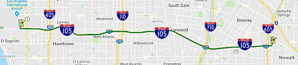 From Pershing Drive near El Segundo to Route 605.
 Post 1964 Signage History
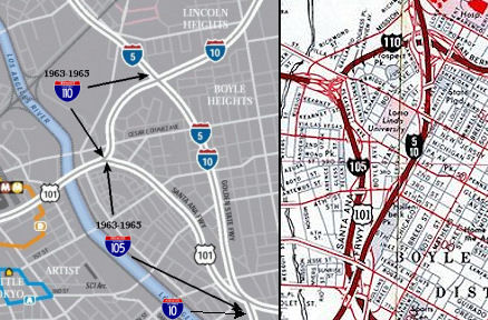 In 1963, Route 105 was defined to run "in Los Angeles
from Route 5 to the junction of Route 110 (now part of Route 10) and
US-101."
In 1963, Route 105 was defined to run "in Los Angeles
from Route 5 to the junction of Route 110 (now part of Route 10) and
US-101."
A 1966 Thomas Brothers Map shows both US 101 and I-105 on the segment between US 101/Northern I-10 junction and the US 101/I-5 junction.
In 1968, Chapter 282 transferred that routing to Route 101.
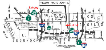
 In 1963 for the "Great Renumbering", Route 42 was defined as "Route 1 west of Inglewood to Route 91 in Santa Ana Canyon via the vicinity of
Norwalk." This incorporated former Route 10, which had to be renumbered to
accommodate I-10, incorporating former LRN 174 and LRN 176.
In 1963 for the "Great Renumbering", Route 42 was defined as "Route 1 west of Inglewood to Route 91 in Santa Ana Canyon via the vicinity of
Norwalk." This incorporated former Route 10, which had to be renumbered to
accommodate I-10, incorporating former LRN 174 and LRN 176.
On June 5,1963, a public hearing was held regarding the Century Freeway (then Route 42) from the Pacific Coast Freeway (Route 1) to the Santa Ana Freeway (I-5).
In 1965, the portion of Route 42 from Route 605 to Route 39 was transferred to Route 90, and the Route 42 was redefined as (1) from Route 1 west of Inglewood to Route 605 and (2) Route 39 near La Habra to Route 91 in Santa Ana Canyon. A 1965 planning map shows this as freeway from Route 405 to Route 605, and then continuing as freeway from Route 605 to Route 91 along what is now Route 90.
In 1966, the state highway map shows the surface routing along Manchester and Firestone, but a proposed freeway routing along the future I-105 (Century Freeway) route.
In 1968, part (1) was transferred to Route 105, and part (2) was transferred to Route 90. Part (1) became the "Century Freeway", and part (2) became the "Yorba Linda Freeway". This resulted in the deletion of Route 42 (field signage notwithstanding).
Chapter 282 in 1968 transferred the original downtown LA spur routing of Route 105 to US 101, and redefined Route 105 as "Route 1 west of
Inglewood to Route 605." (transferring the route from Route 42)
Caltrans recommended the current route in 1968, which is also when the route was added to the Interstate highway system. The interstate mileage for I-105 came from 23 USC 103 and the Howard Cramer act. 10.3 miles of the 17 mile route came from 23 USC 103(e)(1), and 7 miles were Howard Cramer substitutions from 23 USC 103(e)(2). The 7 miles came from the following routes:
Adding the route to the Interstate system prompted a highway renumbering. In 1968, a segment of Route 42 was transferred to Route 105: "Route 1 west of Inglewood to Route 605." The former surface routing of Route 42 was eventually dropped from the state system (although signs remained for years).
Designing the freeway took from 1968 to 1972. By 1970, the proposed route was roughly as it is now, and the cost was estimated at $190 million. In 1972, a class action lawsuite was filed to block the freeway's construction. Under this lawsuit, all freeway construction was halted until a number of requirements, including a formal environmental impact statement and public hearings, were conducted. This lawsuit was settled by consent decree in 1979; however, the delay had substantially raised the cost of construction. To salvage the project, the scope was reduced by eliminating two traffic lanes, 11 local interchanges, and 500 units of replacement housing. The court approved the amended consent degree in 1981. The meant that there was design rework to be done, as well as new freeway agreements with local governments, right of way acquisitions, etc.
In 1981, Chapter 292 changed the origin of the route to "The south boundary of the Los Angeles International Airport near El Segundo".
Caltrans was also pressure to have construction substantially started in 1986 (deadline imposed by federal law); that law also stated the last federal funding authorization for such construction would be provided in 1990. Actual construction of the freeway began in 1982.
In 1992, Chapter 1243 changed the origin to "Pershing Drive near El Segundo".
The freeway gradually opened to traffic in 1993 and 1994, at a cost of $2.3 billion.
The Infamous I-105 Gap Between I-605 and I-5
There are a number of reasons why I-105 doesn't go all the way to I-5:
Groundwater Problems
A significant problem with I-105 has been groundwater. The original design of the freeway included both elevated, ground level, and below ground level portions. Of concern is a 3.5 mile below ground level section between I-710 and I-605. This was originally much shorter, but in 1981 was extended W towards I-710 (and the Los Angeles River). According to a report from the California State Auditor ("Department of Transportation: Disregarding Early Warnings Has Caused Millions of Dollars to be Spent Correcting Century Freeway Design Flaws" [August 1999, #99113]), did not do extensive tests of soils and groundwater conditions before constructions. They believed the groundwater was 30 feet below the construction level. However, Caltrans was impacted by the actions of another agency, which as a result of overpumping the groundwater basin in the 1950s, was replenishing the basin, increasing groundwater levels. The net result was cracking and sinking of the 3.5 mile section, requiring expensive repairs.
 Pre 1964 Signage History
The present route of I-105 was not defined before 1964. The 1964-1968 routing of I-105 in downtown LA was part of LRN 2.
I-105 runs roughly parallel
to Imperial Highway from El Segundo to Norwalk. The name "Imperial" refers
to the Imperial Valley, which took its name from the Imperial Land Co., a
subsidiary of the California Development Company charged with reclaiming
the water-starved but arable land east of San Diego for agricultural
purposes in the early 1900s. The company began building canals in 1900,
diverting water from the Colorado River for irrigation, and forming the
Salton Sea in the process. The Los Angeles area wanted to patch together a
superhighway that would stretch from the Pacific all the way to Brawley in
the Imperial Valley, a distance of 215 miles; the route was later extended
a few miles farther south to El Centro. The most route roughly followed
the old Butterfield Stage overland route, established in 1858: across the
desert (Route 78) and along today’s Route 79 to Temecula, where it
headed on to Corona via Lake Elsinore and Temescal Canyon (Route 71, later
I-15). There the road turned left down the Santa Ana Canyon on its way to
Yorba Linda (present-day Route 91) and La Habra (present-day Route 90),
then across Los Angeles County to meet the sea at El Segundo (as Imperial
Highway, although it is paralleled by I-105). The extension to Brawley was
along Route 86 The early Imperial Highway plans involved connecting a
patchwork assortment of roads of varying length and quality. In
1912, a group of Los Angeles boosters informally known as the Committee of
One Hundred, working with Los Angeles, San Bernardino, Orange, Riverside
and Imperial counties, settled on a route along the edge of the inland
Salton Sea that completely bypassed San Diego County, from which Imperial
County had been split off in 1907. The Los Angeles section of road would
be mostly a straight shot from LAX to Anaheim, where the proposed road
would dip south diagonally before eventually reaching the Imperial Valley.
By the 1920s, the efficacy of the Imperial Highway concept had become
apparent, and a new and more forceful private group, the Imperial Highway
Association, was formed in 1929 to encourage the regions involved to mount
a fully cooperative effort, including working closely with San Diego
County, to get the job done. The association adopted an official route for
a more streamlined, uniform highway in 1931 that ran slightly west of the
earlier Salton Sea route. The improved roadway, now referred to informally
as “the Cannon Ball Road,” would eliminate tight right angle
turns that slowed trucks, smooth and widen the various roadways involved,
and have new bridges where necessary. A major section in Yorba Linda was
completed in 1937. Two-lane portions of the highway through Inglewood had
to be expanded to four. A bridge over the Los Angeles River,
completed in 1951, eliminated a crucial bottleneck; it replaced an old one
that collapsed in 1948. The final section of the Imperial Highway as
envisioned by the association was completed, and it was dedicated a scenic
highway in a ceremony on the Imperial-San Diego county border in December
1961. Of its 220 total miles, 77 were county roads, with the rest being
state highways. The cost to complete the project was estimated at $16
million (about $138 million in 2020 dollars). In 1965, Caltrans planned a
new freeway along the path of Imperial Highway, from LAX to Norwalk. It
opened in 1993 as I-105, though Imperial Highway itself remained in place,
if somewhat less crucial than it once was. Through Orange County, Imperial
Highway was Route 90. Major chunks of the roadway through Riverside and
San Diego counties were subsumed by newer freeways and highways over the
years. The 41-mile Los Angeles stretch, which passes through El Segundo,
Hawthorne, Inglewood, South Los Angeles, Lynwood, South Gate, Downey,
Norwalk, Santa Fe Springs and La Mirada, retains the original Imperial
Highway name, as does a section of Route 86 in El Centro (also known as
Imperial Avenue).
(Source: Daily Breeze, “South Bay History: Imperial Highway once figured as part of a superhighway plan”, 3/29/2021; Orange County History “The Imperial Highway”, 2011)
However, the current route of I-105, or something similar to it, had been on the drawing board of city planners since at least 1947. It shows up in the 1949 proposed parkway system from the ACSC as the Inglewood-Slauson Parkway, but it ran a little further north than the current I-105 (specifically, it ran from roughly the present I-405/Florence Ave area to near Normandie and Slauson, then roughly along Slauson and Randolph to the Santa Ana Parkway).
There was also signed Route 10, renumbered in 1961 as Route 42, which was the predecessor of this routing. The pre-1964 routing for Route 42 ran only between US 101A (now Route 1) and US 101 (now Route 5). Route 42 was originally LRN 174 (defined in 1933) between Route 1 and Route 19, LRN 176, defined in 1933 between Route 39 and Route 91, and extended to Route 19 in 1959. As part of Route 10, portions were signed as Bypass US 101.
By 1956, the concept called the Century Freeway was emerging. It was
distinct from the Slauson Parkway planned along Route 90. The concept ran
from near Century and I-405 to the Long Beach Freeway, meeting that
freeway (then Route 7, now Route 710) near the junction with the Rio Honda
Freeway (Route 164). This routing was 12.4 miles long, with an estimated
cost to complete of $71 milllion. By 1958, the routing was recommended to
extend as far at the Santa Ana Freeway (Route 5). However, it was still
not in the state system with the current routing. Route 42 continued with
the surface routing along Manchester and Firestone
(Underlying image source: CHPW Jan/Feb 1966)
In 1961, it was reported that the Advance Planning was actively studying the Century Freeway between Lincoln Blvd (US 101A) and the Santa Ana Freeway near Norwalk. This was basic route research, focusing on the segment between US 101A and the Harbor Freeway (US 6, present-day I-110).
In 1963, route location studies were started. There were also public hearing on the Century Freeway, again with a planned number of Route 42. Also during 1963, in anticipation of the "Great Renumbering" that would take effect in 1964, Route 42 was extended to run to Route 91 in Santa Ana.
In 1965, the portion of Route 42 from Route 605 to Route 39 was transferred to Route 90, and the routing for Route 42 was redefined as (1) from Route 1 west of Inglewood to Route 605 and (2) Route 39 near La Habra to Route 91 in Santa Ana Canyon. As noted above, in 1968, section (a) was transferred to Route 105, and section (b) went to Route 90.
 During the last quarter of 1965, the CTC adopted a route
extended from Route 1 near the SE corner of LAX to Central Ave in Los
Angeles. This shows on 1966 state highway map as a freeway routing for
Route 42.
During the last quarter of 1965, the CTC adopted a route
extended from Route 1 near the SE corner of LAX to Central Ave in Los
Angeles. This shows on 1966 state highway map as a freeway routing for
Route 42.
 In early 1968, discussions were continuing about the alternatives for the
route (still Route 42) between Central Avenue and I-605. The Green-Orange
Route was recommended by the state highway engineer.
In early 1968, discussions were continuing about the alternatives for the
route (still Route 42) between Central Avenue and I-605. The Green-Orange
Route was recommended by the state highway engineer.
(Source: Southside Journal, 1/4/1968 via Joel Windmiller, 2/19/2023)
Signed Route 105 was not defined in the initial set of state signed routes in 1934.
 Historical Route
In 2019, the Century Freeway-Transitway Historic District, Post
Miles R0.00 through R18.1, was determined eligible for the National
Register at the state level of significance under Criteria A and C.
On December 4, 2019 the California State Historic Preservation SHPO
concurred with the consensus determination of eligibility. It is
considered the last urban interstate constructed and was the subject the
earliest landmark environmental justice lawsuit in California. The
agreements that settled the litigation affected the displacement of
residents and replacement housing, required contractors adhere to
aggressive affirmative action and training programs, the route of the
freeway and its intermodal use. Its design significance is partially
based on its status as the final full-length inner-city interstate, the
requisite incorporation of novel Intelligent Transportation System
features and design components, the integral light rail system and
stations in its median and its massive intermodal interchanges. The period
of significance of the linear historic district is from 1968, when it
began when the initial design was prepared by Caltrans engineers. It
continued through the innovative environmental justice case and consent
decrees, substantial re-design driven by those agreements, implementation
of environmental mitigation measures and construction of the freeway,
transitway and light rail line, closing with completion of the Green Line
in October of 1995. The limits of the Century Freeway-Transitway
Historic District are the Caltrans right of way from California Street in
El Segundo to Studebaker Road in Norwalk, including integral ramps built
as part of the project and the interchanges at I-405, I-110, I-710 and
I-605. Character-defining features include the freeway itself, its
features including the Intelligent Transportation System (ITS), bridges
and ramps constructed or significantly altered as part of the I-105
project, the remaining original landscaping, light rail lines and its ten
freeway-related stations. The pavement of the roadway, standard
signage, soundwalls, mast lighting at the I-710 interchange, pump stations
between I-710 and I-605, the Green Line outside of the median and its
stations south of the Aviation/LAX Station and the Green Line Maintenance
and Storage Yards beyond the I-105 corridor that were not originally
constructed as part of the I-105 do not contribute to its significance.
(Source: Email from Francesca Smith, PQS Principal
Architectural Historian, Caltrans District 7)
 Status
Before the construction of the freeway, the entirety of Route 105 was signed as Route 42. The Caltrans bridge log still indicated that this is the case for a while.
I-405 Connector Tunnels Lighting Improvements (07-LA-105 R1.8/R2.3)
The 2020 SHOPP, approved in May 2020, included the
following new Sign and Lighting Rehabilitation item of interest: 07-LA-105
PM R2.1 PPNO 5507 Proj ID 0719000005 EA 35510. I-105 near Los Angeles
International Airport (LAX), at three connector tunnels with Route 405.
Replace existing lighting with Light Emitting Diode (LED) lighting and add
Transportation Management System (TMS) elements. Programmed in FY22-23,
with construction scheduled to start at the end of July 2023. Total
project cost is $30,377K, with $22,181K being capital (const and right of
way) and $8,196K being support (engineering, environmental, etc.),
(Source: 2020 Approved SHOPP a/o May 2020)
In October 2021, the CTC approved the following SHOPP
amendment: 07-LA-105 R2.1 R1.8/R2.3. PPNO 07-5507;
ProjID 0719000005; EA 35510. I-105 Near Los Angeles International Airport
(LAX), at three connector tunnels with Route 405. Replace existing
lighting with Light Emitting Diode (LED) lighting and add Transportation
Management System (TMS) elements. Note: Decrease in construction capital,
construction support, and R/W capital is due to an error in calculating
escalation, which has been corrected. Update postmiles to capture
entire scope of work. Allocation changes ($1000s): Con Sup $4,519 ⇒
$4,000; Const Cap $22,161 ⇒ $20,731; Total $29,933
⇒ $27,981.
(Source: October 2021 CTC Agenda, Agenda Item
2.1a.(1d) #5)
In August 2023, the CTC approved the following SHOPP
Construction Phase allocation: $24,756,000. 07-LA-105 R1.5/R2.6. PPNO
07-5507; ProjID 0719000005; EA 35510. I-105 Near Los Angeles International
Airport (LAX), at E105-S405 Tunnel № 53-2436G, E105-N405 Tunnel
№ 53-2437G, and W105-S405 Tunnel № 53-2441F. Outcome/Output:
Replace existing lighting with Light Emitting Diode (LED) lighting and add
Transportation Management System (TMS) elements. This project will
improve visibility and have a longer service life than the current system
to reduce maintenance needs. Preliminary Engineering (Budget / Expended):
PA&ED $991,000 / $293,419; PS&E $2,500,000 / $1,632,750;
R/W Sup $117,000 / $17,850. CEQA - CE, 5/12/2021;
Re-validation 2/22/2023. NEPA - CE, 5/12/2021; Re-validation 2/22/2023.
Two month allocation time extension for CONST and CON ENG approved under
Waiver 23-72; June 2023. Allocation: (Programmed / Allocated):
CON ENG $4,000,000 / $4,000,000; CONST $20,731,000 / $20,756,000.
(Source: August 2023 CTC Agenda, Agenda Item 2.5b.(1) #41)
The SAFETEA-LU act, enacted in August 2005 as the reauthorization of TEA-21, provided the following expenditures on or near this route:
I-105 ExpressLanes Project (07-LA-105, PM R0.5/R1 8.1; 07-LA-110, PM R13.8/R14.8)
 In September 2010, the CTC approved for future
consideration of funding a project in Los Angeles County will convert High
Occupancy Vehicle lanes to High Occupancy Toll lanes. The project was
covered environmentally with two separate environmental documents, one
document for the Route 110 and Route 105 portion of the project and one
document for the Route 10 and Route 10S portion of the project (Route 10S
is the El Monte Busway spur to Union Station). The project is programmed
in the State-Local Partnership Program and includes federal and local
funds. Construction is estimated to begin in Fiscal Year 2010-11. Total
estimated project cost is $69,300,000 for capital and support. The project
will not involve a substantial amount of construction activities but due
to public interest and controversy associated with toll lanes and the
large amount of public outreach and education involved with the project it
was decided to prepare a higher level of environmental document.
In September 2010, the CTC approved for future
consideration of funding a project in Los Angeles County will convert High
Occupancy Vehicle lanes to High Occupancy Toll lanes. The project was
covered environmentally with two separate environmental documents, one
document for the Route 110 and Route 105 portion of the project and one
document for the Route 10 and Route 10S portion of the project (Route 10S
is the El Monte Busway spur to Union Station). The project is programmed
in the State-Local Partnership Program and includes federal and local
funds. Construction is estimated to begin in Fiscal Year 2010-11. Total
estimated project cost is $69,300,000 for capital and support. The project
will not involve a substantial amount of construction activities but due
to public interest and controversy associated with toll lanes and the
large amount of public outreach and education involved with the project it
was decided to prepare a higher level of environmental document.
In March 2016, the Los Angeles MTA presented its full
proposal for what transit lines could be built -- and when -- if Los
Angeles County voters approve a half-cent sales tax increase in November
2016. This proposal included funding for I-105 Express Lanes from I-405 to
I-605 (~ LA R2.044 to LA R17.789). The project would re-stripe the
existing HOV lane to create 2 Express Lanes in each direction for a total
of 16 miles, while maintaining current number of mixed flow lanes in each
direction.
(Source: Los Angeles Times 3/18/2016; Metro Board Report 3/24/2016)
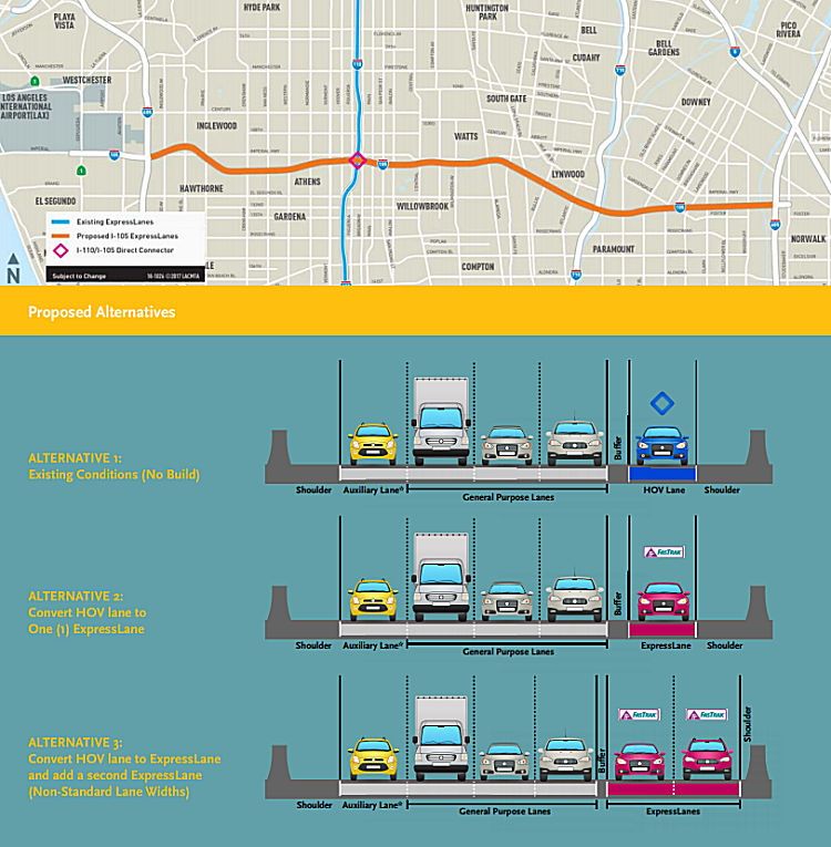
In late March 2019, meetings were announced for April 2019 on the I-105 Express Lanes project. Metro and the California Department of Transportation (Caltrans) are preparing engineering studies and an Environmental Document to study the possible implementation of ExpressLanes along I-105 between I-405 and I-605. The project will also study the I-105 west of the I-405 to Sepulveda Bl and east of the I-605 to Studebaker Rd to identify potential signage locations and access points into the ExpressLanes. In 2015, Caltrans completed a Project Study Report/ Project Development Support (PSR/PDS) for the I-105 corridor to assess potential improvements. The PSR/PDS identified four alternatives including a no build, conversion of the existing High Occupancy Vehicle (HOV) lane into ExpressLanes, and the addition of a second ExpressLane in each direction. In January 2017, the ExpressLanes Strategic Plan was presented to the Metro Board. The Strategic Plan identified three tiers of ExpressLanes projects, with Tier 1 projects showing the highest potential benefits. Tier 1 projects include the I-105, sections of the I-405 and I-605, and extensions of the existing I-10 and I-110 ExpressLanes. Next, Metro and Caltrans began the preparation of the Environmental Impact Report/Environmental Assessment to evaluate the environmental effects of this project pursuant to the California Environmental Quality Act (CEQA) and the National Environmental Policy Act (NEPA). As part of this effort, Metro hosted public scoping meetings along the corridor in March 2018 to get input from the community on the proposed alternatives and project. The I-105 ExpressLanes are included in Measure M, the local sales tax passed by Los Angeles County voters in 2016. Measure M provides $175 million for this project.
Metro and Caltrans are studying the following proposed
Alternatives:
(Source: Image from I–105 Express Lanes Fact Sheet)
In May 2020, it was reported that the Draft EIR for
this project had been released for public review. Based on the conceptual
analysis and preliminary engineering studies, the Draft EIR proposed two
Build Alternatives in addition to a “No-Build” Alternative:
(Source: Metro "The Source" 5/22/2020; Draft EIR, April 2020)
It appears that the original Alternative 4 was dropped
due to various significant environmental impacts. Fifty-four structures
would need to be widened or modified and thirty-six structures would need
to be reconstructed. In addition, fifty-four on and off ramps will be
impacted and require reconfiguration. Approximately, thirty-two
residential buildings and 2 large commercial/industrial parcels would need
to be entirely acquired. An agreement with Union Pacific Railroad
(UPRR) would be needed to relocate tracks between Budlong Avenue and
Vermont Avenue. Right-of-way acquisition would be needed at an estimated
cost of $50 to $100 million. Figures 1-5 and 1-6 provide examples of the
potential impact of Alternative 4. During the scoping period, comments
received from the public and agencies indicated support for dropping
Alternative 4 from further evaluation due to right-of-way impacts. Other
alternatives considered were: (1) Operational Alternative Single
ExpressLane 2+ occupancy policy; and (2) Reversable Lanes.
(Source: Metro "The Source" 5/22/2020; Draft EIR, April 2020)
In December 2020, it was reported that the CTC approved
$150 million in Solutions for Congested Corridors Program funds for the
I-105 ExpressLanes Expansion. The project will build ExpressLanes on I-105
for 16 miles between I-405 and I-605 — a very busy stretch of
freeway used by many people to travel to and from LAX. There will be two
ExpressLanes in each direction, including the existing HOV lane that will
be converted to an ExpressLane. The project is expected to reduce daily
vehicle delays in both the ExpressLanes and general purpose lanes —
and shave minutes off travel time in all lanes.
(Source: Metro "The Source" 12/2/2020)
In August 2021, the CTC approved the following project
for future consideration of funding: 07-LA-105, PM R0.5/R1 8.1; 07-LA-110,
PM R13.8/R14.8. I-105 ExpressLanes Project. Construct a
continuous managed lanes facility on I-105 Los Angeles County. (FEIR)
(PPNO 4858) (STIP). This project is located on I-105 between the Sepulveda
Boulevard/Imperial Highway Intersection and Studebaker Road and on I-110
between the I-105 Separation and 103rd Street, in Los Angeles County. The
Department proposes to convert the existing High Occupancy Vehicle lane on
the I-105, from I-405 to Studebaker Road, to two express lanes in each
direction with nonstandard lane and shoulder widths. The two express lanes
will be separated from the general-purpose lanes by a two-foot wide
buffer. The project would also include a new overhead tolling system and
signage with dynamic pricing on the express. The project is fully funded
and is currently programmed in the 2020 STIP for a total of $609,121,000,
which includes local funds, Solutions for Congested Corridors Program
funds, and Congested Mitigation and Air Quality Program funds.
Construction is estimated to begin in 2023-24. The scope, as described for
the preferred alternative, is consistent with the project scope as
programmed by the Commission in the 2020 STIP. A copy of the FEIR has been
provided to Commission staff. Impacts associated with the project are less
than significant, but public interest necessitated preparation of an
FEIR. As a result, an FEIR was prepared for the project.
(Source: August 2021 CTC Agenda, Agenda Item
2.2c.(3))
In February 2003, the segment from PM R5.5/R6.0 in the County of Los Angeles was on the CTC agenda for relinquishment.
In March 2005, the CTC considered relinquishment of two segments of right of way in the City of Paramount, between Ruther Avenue and Grant Avenue (~ LA R14.706 to LA R15.177), consisting of reconstructed and relocated city streets and frontage roads. The City, by freeway agreement dated June 2, 1987, agreed to accept title upon relinquishment by the State.
 Commuter Lanes
Commuter lanes exist on this route between Route 405 and Route 605. They were opened in October 1993, require two or more occupants, and are in operation 24 hours a day. They have their own exit ramps, including a 122-ft. high 5-level interchange with I-110.
 Interstate Submissions
Approved as chargeable interstate in March 1968 as a result of 10 miles being freed in San Francisco, and 7 miles of Howard-Cramer.
In April 1958, as part of the first attempt to assign 3-digit interstates, the designation I-105 was proposed for what is now I-605.
In August 1958, the segment of US 101 between the San Bernardino Freeway and the Santa Monica Freeway was proposed (and approved) as I-105. This numbering lasted until 1968, when the segment was returned to US 101. In 1968, the stub of the San Bernardino Freeway from US 101 to I-5 was renumbered from I-110 to I-10, and the section of US 101 between the US 101/I-10 junction and the I-10/I-5/US 101 junction was renumbered from I-105 to US 101.
 Naming
 The segment of Route 105 from Route 1 (LA
R0.528) to Route 605 (LA R18.083) is officially the "Glenn Anderson
Freeway". The first segment opened in 1993, and the last segment
opened in 1994. It was named by Senate Concurrent Resolution No. 34,
Chapter 83, in 1987. Glenn Anderson was a US Congressman that represented
the South Bay-Mid Cities portion of Los Angeles County. He was
instrumental in getting federal funding for various transportation
projects in the region, including the Metro Red Line subway and the I-105
Freeway. Anderson received a Bachelor of Arts from University of
California, Los Angeles in 1936, and worked as a real estate developer and
served in the United States Army before entering politics. Anderson was
mayor of Hawthorne from 1940 to 1943 and a member of the California State
Assembly from 1943 to 1950. He served as Lieutenant Governor of California
from 1959 to 1967 but was defeated in a bid for a third term by Republican
Robert Finch. During his office on August 13, 1965, he signed off on the
orders to send 1,336 National Guard Troops into Los Angeles County, 48
hours after the Watts riots begun. Anderson was first elected to the 91st
Congress in 1968 and served 12 terms from 1969 to 1993. In Congress he
became chair of the Committee on Public Works and Transportation. He
decided not to run for re-election in 1992. He retired in 1993 and died in
1994.
The segment of Route 105 from Route 1 (LA
R0.528) to Route 605 (LA R18.083) is officially the "Glenn Anderson
Freeway". The first segment opened in 1993, and the last segment
opened in 1994. It was named by Senate Concurrent Resolution No. 34,
Chapter 83, in 1987. Glenn Anderson was a US Congressman that represented
the South Bay-Mid Cities portion of Los Angeles County. He was
instrumental in getting federal funding for various transportation
projects in the region, including the Metro Red Line subway and the I-105
Freeway. Anderson received a Bachelor of Arts from University of
California, Los Angeles in 1936, and worked as a real estate developer and
served in the United States Army before entering politics. Anderson was
mayor of Hawthorne from 1940 to 1943 and a member of the California State
Assembly from 1943 to 1950. He served as Lieutenant Governor of California
from 1959 to 1967 but was defeated in a bid for a third term by Republican
Robert Finch. During his office on August 13, 1965, he signed off on the
orders to send 1,336 National Guard Troops into Los Angeles County, 48
hours after the Watts riots begun. Anderson was first elected to the 91st
Congress in 1968 and served 12 terms from 1969 to 1993. In Congress he
became chair of the Committee on Public Works and Transportation. He
decided not to run for re-election in 1992. He retired in 1993 and died in
1994.
(Image Source: Subway Nut, AAroads, Wikipedia)
 The segment of Route 105 from Route 1 (LA R0.528) to Route 605 (LA
R18.083) is called the Century Freeway in common uages. This
relates to the fact that the route roughly follows Century Blvd.
The segment of Route 105 from Route 1 (LA R0.528) to Route 605 (LA
R18.083) is called the Century Freeway in common uages. This
relates to the fact that the route roughly follows Century Blvd.
(Image Source: Interstate 105 - The Fight for a Changing Los Angeles)
The segment of Route 105 from Route 1 (LA R0.528) to Route 405 (LA R2.155) is also officially named the "El Segundo Freeway". It was named by Assembly Concurrent Resolution No. 46, Chapter 362, in 1969. El Segundo refers to the route's terminus in El Segundo, which its was named after the local oil refinery. The refinery was named by the Standard Oil Company in 1911 as its second (segundo) refinery in California (first was in Richmond (which was not named El Primero)).
The segment of Route 105 from Route 405 (LA R2.155) to Route 605 (LA R18.083) is also officially named the "Norwalk Freeway". It was named by Assembly Concurrent Resolution No. 46, Chapter 362, in 1969.
 The portion of I-105 from I-110 (~ LA R7.386) to the Long
Beach Boulevard Undercrossing (~ LA R11.506) in the County of Los Angeles
is named the "Los Angeles County Sheriff’s Deputy Didier M.
Hurdle Memorial Highway". It was named in memory of Los Angeles
County Sheriff’s Deputy Didier M. Hurdle who was killed in the line
of duty. Deputy Hurdle was shot and killed on Friday, November 25, 1977,
in the community of Willowbrook, California at the intersection of South
Oleander Avenue and East Knopf Street. Deputy Hurdle was shot and killed
when he and a cadet trainee stopped a car containing suspected gang
members, and as one of the suspects exited the vehicle and opened fire,
the cadet was wounded in the leg and shoulder, but was able to return
fire. During the gun battle, Deputy Hurdle and the cadet were able to
wound one of the suspects while the responding deputy sheriffs were able
to follow the suspect’s blood trail and apprehend all of the
suspects who were charged with murder of a police officer and possession
of PCP. Deputy Hurdle, although wearing a ballistic vest, was shot in the
shoulder and the bullet deflected downward into his chest causing his
death from the wound. Deputy Hurdle was only 36 years of age at the time
of his passing, and had served 8 years and 6 months and 10 days since his
appointment as a deputy sheriff on May 15, 1969. Even today, more than 40
years since his passing, Deputy Sheriff Didier M. Hurdle is remembered by
his fellow officers, colleagues, and his surviving family and loved ones
who honor his memory annually. Named by Assembly Concurrent Resolution
(ACR) 214, Res. Chapter 170, 8/28/2018.
The portion of I-105 from I-110 (~ LA R7.386) to the Long
Beach Boulevard Undercrossing (~ LA R11.506) in the County of Los Angeles
is named the "Los Angeles County Sheriff’s Deputy Didier M.
Hurdle Memorial Highway". It was named in memory of Los Angeles
County Sheriff’s Deputy Didier M. Hurdle who was killed in the line
of duty. Deputy Hurdle was shot and killed on Friday, November 25, 1977,
in the community of Willowbrook, California at the intersection of South
Oleander Avenue and East Knopf Street. Deputy Hurdle was shot and killed
when he and a cadet trainee stopped a car containing suspected gang
members, and as one of the suspects exited the vehicle and opened fire,
the cadet was wounded in the leg and shoulder, but was able to return
fire. During the gun battle, Deputy Hurdle and the cadet were able to
wound one of the suspects while the responding deputy sheriffs were able
to follow the suspect’s blood trail and apprehend all of the
suspects who were charged with murder of a police officer and possession
of PCP. Deputy Hurdle, although wearing a ballistic vest, was shot in the
shoulder and the bullet deflected downward into his chest causing his
death from the wound. Deputy Hurdle was only 36 years of age at the time
of his passing, and had served 8 years and 6 months and 10 days since his
appointment as a deputy sheriff on May 15, 1969. Even today, more than 40
years since his passing, Deputy Sheriff Didier M. Hurdle is remembered by
his fellow officers, colleagues, and his surviving family and loved ones
who honor his memory annually. Named by Assembly Concurrent Resolution
(ACR) 214, Res. Chapter 170, 8/28/2018.
(Image Sources: Twitter post from LA County Sheriff; OfficerDown
Memorial Page)
 Named Structures
 The freeway interchange between Route 105 and Route 405 is officially designated the "Sadao
S. Munemori Memorial Freeway Interchange". Sadao S. Munemori, an
American of Japanese ancestry, served in the 100th Infantry Battalion of
the US Army, a unit composed mainly of Japanese-Americans from Hawaii.
This battalion later became part of the 442nd Regimental Combat Team, the
most highly decorated unit of World War II for its size and time in
combat. In March 1945, Private Munemori and his company were ordered back
to Northern Italy to join forces in the final push against the Gustav
Line, a fortified German position that had held up the Allied advance for
more than four months. On April 5, 1945, the company came under murderous
fire, and its commander, Lt. David Novack, and squad leader, Staff Sgt.
Kei Yamaguchi, were severely wounded and Private Munemori took command and
single handedly, using grenades, knocked out two enemy machine guns,
giving his own life to save two of his comrades when he used his own body
to shield them from an exploding enemy grenade. Munemori was born in Los
Angeles, California to Japanese immigrant parents Kametaro and Nawa
Munemori. He was a Nisei, a second generation Japanese American. He grew
up in the suburb of Glendale and graduated from Abraham Lincoln Senior
High School in 1940 before becoming an auto mechanic. Munemori had
volunteered for the U.S. Army in November 1941, one month before the
Japanese attack on Pearl Harbor, and he was inducted in February 1942.
Along with all other Japanese American soldiers, he was soon after demoted
to 4-C class, removed from combat training and assigned to menial labor.
While he was transferred to a series of Midwestern and Southern army bases
(eventually winding up at Camp Savage, Minnesota), his parents and
siblings were incarcerated at Manzanar. When Japanese American soldiers
were allowed to reenter active service in March 1943, Munemori volunteered
to be part of the all-Nisei 442nd Regimental Combat Team. After the Allied
capture of Rome, the battalion withdrew from the front and became the 1st
Battalion of the 442nd RCT. Munemori was sent to Camp Shelby in January
1944 and, after completing his combat training three months later, joined
the 100th Battalion in the European Theater. Fighting in Italy and France,
he participated in the rescue of the Lost Battalion before arriving on the
Gothic Line, where he was killed in action. Named by Senate Concurrent
Resolution No. 41, Chapter 131, in 1994.
The freeway interchange between Route 105 and Route 405 is officially designated the "Sadao
S. Munemori Memorial Freeway Interchange". Sadao S. Munemori, an
American of Japanese ancestry, served in the 100th Infantry Battalion of
the US Army, a unit composed mainly of Japanese-Americans from Hawaii.
This battalion later became part of the 442nd Regimental Combat Team, the
most highly decorated unit of World War II for its size and time in
combat. In March 1945, Private Munemori and his company were ordered back
to Northern Italy to join forces in the final push against the Gustav
Line, a fortified German position that had held up the Allied advance for
more than four months. On April 5, 1945, the company came under murderous
fire, and its commander, Lt. David Novack, and squad leader, Staff Sgt.
Kei Yamaguchi, were severely wounded and Private Munemori took command and
single handedly, using grenades, knocked out two enemy machine guns,
giving his own life to save two of his comrades when he used his own body
to shield them from an exploding enemy grenade. Munemori was born in Los
Angeles, California to Japanese immigrant parents Kametaro and Nawa
Munemori. He was a Nisei, a second generation Japanese American. He grew
up in the suburb of Glendale and graduated from Abraham Lincoln Senior
High School in 1940 before becoming an auto mechanic. Munemori had
volunteered for the U.S. Army in November 1941, one month before the
Japanese attack on Pearl Harbor, and he was inducted in February 1942.
Along with all other Japanese American soldiers, he was soon after demoted
to 4-C class, removed from combat training and assigned to menial labor.
While he was transferred to a series of Midwestern and Southern army bases
(eventually winding up at Camp Savage, Minnesota), his parents and
siblings were incarcerated at Manzanar. When Japanese American soldiers
were allowed to reenter active service in March 1943, Munemori volunteered
to be part of the all-Nisei 442nd Regimental Combat Team. After the Allied
capture of Rome, the battalion withdrew from the front and became the 1st
Battalion of the 442nd RCT. Munemori was sent to Camp Shelby in January
1944 and, after completing his combat training three months later, joined
the 100th Battalion in the European Theater. Fighting in Italy and France,
he participated in the rescue of the Lost Battalion before arriving on the
Gothic Line, where he was killed in action. Named by Senate Concurrent
Resolution No. 41, Chapter 131, in 1994.
(Image Source: AAroads; Wikipedia)
 The I-110/I-105 interchange is named
the "Judge Harry Pregerson Interchange". It was named in honor of
Judge Harry Pregerson, who was born in Los Angeles, California in 1923.
Judge Pregerson received his Bachelor of Arts from the University of
California, Los Angeles in 1947, and was awarded a Bachelor of Laws from
the University of California, Berkeley, Boalt Hall School of Law in 1950.
He served his country as a United States Marine Corps First Lieutenant
from 1944 to 1946 and was severely wounded in the battle of Okinawa in
World War II. Pregerson was an attorney in private practice from 1951 to
1965, was a judge of the Los Angeles Municipal Court from 1965 to 1966,
was a judge of the Los Angeles Superior Court from 1966 to 1967, was
appointed to the United States District Court for the Central District of
California on December 7, 1967, and was appointed to the United States
Court of Appeals for the Ninth Circuit on November 2, 1979. Judge
Pregerson presided over the Century Freeway lawsuit for more than two
decades starting in 1972, and kept control of the case for more than a
dozen years after he was elevated to the appeals court even though he
could have surrendered it to another judge. Additionally, Judge Harry
Pregerson ensured the construction of nearly 5,000 affordable housing
units to replace homes removed to make way for the Century Freeway and
oversaw the housing program under a consent decree from 1972 to 1995.
Pregerson insisted that a major portion of the construction jobs involved
in the building go to minorities and women and, when there were not enough
minorities and women qualified for the jobs, he helped to create a
construction apprenticeship program for them. The Century Freeway Housing
Program, now known as the Century Housing Corporation, a nonprofit
organization, grew out of the settlement of the Century Freeway lawsuit
presided over by Judge Harry Pregerson, and provided funds to acquire the
Westwide Residence Hall which houses 500 formerly homeless veterans and is
the largest housing and employment center for homeless veterans in the
country. The settlement of the Century Freeway lawsuit permitted
construction of I-105, known as the Century Freeway. In 1988 Judge Harry
Pregerson founded the Bell Homeless Shelter, of which one-third of the
clients are veterans, at a federal supply center in southeast Los Angeles
County. The next year, Pregerson partnered with charities, veterans
groups, labor organizations, the federal General Services Administration,
and then Los Angeles Mayor Tom Bradley to start the Westwood Transitional
Village, which provided furnished apartments for homeless families, with
preference given to veterans. Five years later, in 1994, Judge Pregerson
helped start the Salvation Army’s Haven Program, which arranges
housing and provides support services for homeless veterans. Additionally,
Judge Pregerson helped bring together judges, law enforcement, and county
officials to create a “homeless court,” which can clear an
offender’s record of minor violations, providing an incentive for
homeless individuals to complete a rehabilitation program and return to a
productive life. Until December 2015, Judge Harry Pregerson was the oldest
active judge on the Ninth Circuit Court of Appeals. He retired 12/27/2015 at the age of 92. The article on his retirement included the following quote: "I can't think of anything more important than to try
to help as many people as you can. That is a big motivator for me.
Sometimes the law is not very compassionate." Named by Assembly Concurrent
Resolution 142, Resolution Chapter 43, May 3, 2002.
The I-110/I-105 interchange is named
the "Judge Harry Pregerson Interchange". It was named in honor of
Judge Harry Pregerson, who was born in Los Angeles, California in 1923.
Judge Pregerson received his Bachelor of Arts from the University of
California, Los Angeles in 1947, and was awarded a Bachelor of Laws from
the University of California, Berkeley, Boalt Hall School of Law in 1950.
He served his country as a United States Marine Corps First Lieutenant
from 1944 to 1946 and was severely wounded in the battle of Okinawa in
World War II. Pregerson was an attorney in private practice from 1951 to
1965, was a judge of the Los Angeles Municipal Court from 1965 to 1966,
was a judge of the Los Angeles Superior Court from 1966 to 1967, was
appointed to the United States District Court for the Central District of
California on December 7, 1967, and was appointed to the United States
Court of Appeals for the Ninth Circuit on November 2, 1979. Judge
Pregerson presided over the Century Freeway lawsuit for more than two
decades starting in 1972, and kept control of the case for more than a
dozen years after he was elevated to the appeals court even though he
could have surrendered it to another judge. Additionally, Judge Harry
Pregerson ensured the construction of nearly 5,000 affordable housing
units to replace homes removed to make way for the Century Freeway and
oversaw the housing program under a consent decree from 1972 to 1995.
Pregerson insisted that a major portion of the construction jobs involved
in the building go to minorities and women and, when there were not enough
minorities and women qualified for the jobs, he helped to create a
construction apprenticeship program for them. The Century Freeway Housing
Program, now known as the Century Housing Corporation, a nonprofit
organization, grew out of the settlement of the Century Freeway lawsuit
presided over by Judge Harry Pregerson, and provided funds to acquire the
Westwide Residence Hall which houses 500 formerly homeless veterans and is
the largest housing and employment center for homeless veterans in the
country. The settlement of the Century Freeway lawsuit permitted
construction of I-105, known as the Century Freeway. In 1988 Judge Harry
Pregerson founded the Bell Homeless Shelter, of which one-third of the
clients are veterans, at a federal supply center in southeast Los Angeles
County. The next year, Pregerson partnered with charities, veterans
groups, labor organizations, the federal General Services Administration,
and then Los Angeles Mayor Tom Bradley to start the Westwood Transitional
Village, which provided furnished apartments for homeless families, with
preference given to veterans. Five years later, in 1994, Judge Pregerson
helped start the Salvation Army’s Haven Program, which arranges
housing and provides support services for homeless veterans. Additionally,
Judge Pregerson helped bring together judges, law enforcement, and county
officials to create a “homeless court,” which can clear an
offender’s record of minor violations, providing an incentive for
homeless individuals to complete a rehabilitation program and return to a
productive life. Until December 2015, Judge Harry Pregerson was the oldest
active judge on the Ninth Circuit Court of Appeals. He retired 12/27/2015 at the age of 92. The article on his retirement included the following quote: "I can't think of anything more important than to try
to help as many people as you can. That is a big motivator for me.
Sometimes the law is not very compassionate." Named by Assembly Concurrent
Resolution 142, Resolution Chapter 43, May 3, 2002.
(Image Source: BerkeleyLaw, 11/30/2017)
 The freeway interchange between Route 105
and Route 605 (~ LA R17.789) is officially designated the "Joe A.
Gonsalves Memorial Interchange". Joe A. Gonsalves was born to
Joaquim Gonsalves and Elvira Silva Gonsalves in Holtville, California, on
October 13, 1919. He was elected to the City Council of the City of Dairy
Valley, now known as the City of Cerritos, in 1958, and was twice elected
the Mayor of Dairy Valley. In 1962, he was elected to the California State
Assembly, representing the 66th Assembly District (making him the first
person of Portuguese ancestry to be elected to the California State
Legislature). During his 12 years in the California Legislature he served
as Chair of the Assembly Rules Committee, Revenue and Taxation Committee,
and the Joint Committee on Rules and, served as a member of the Assembly
Education Committee, and the State Allocation Board. In 1963, during his
legislative tenure, Section 405 of the Streets and Highways Code was
enacted, describing Route 105 as running from Route 5, to the junction of
Route 101 and Route 110, which would have caused Route 105 to cut through
the Cities of Norwalk and La Mirada [Note: The above is from the
resolution, and reflects poor research. The current incarnation of Route 105 wasn't defined as Route 105 in 1963; the closest routing was pre-1968
Route 42]. At the requests of the Cities of Norwalk and La Mirada and
their residents, Joe A. Gonsalves was instrumental in having Section 405
of the Streets and Highways Code amended in 1968, so that Route 105 ended
at Route 605 rather than cutting through the Cities of Norwalk and La
Mirada (thus, those of you who complain that I-105 doesn't go through to
I-5 have Mr. Gonsalves to blame). After leaving the legislature, Joe A.
Gonsalves operated the only three-generation lobbying firm in Sacramento,
with his son, Anthony Gonsalves, and his grandson, Jason Gonsalves. Joe A.
Gonsalves passed away on July 7, 2000. Named by Assembly Concurrent
Resolution 96, Chapter 129, September 24, 2001.
The freeway interchange between Route 105
and Route 605 (~ LA R17.789) is officially designated the "Joe A.
Gonsalves Memorial Interchange". Joe A. Gonsalves was born to
Joaquim Gonsalves and Elvira Silva Gonsalves in Holtville, California, on
October 13, 1919. He was elected to the City Council of the City of Dairy
Valley, now known as the City of Cerritos, in 1958, and was twice elected
the Mayor of Dairy Valley. In 1962, he was elected to the California State
Assembly, representing the 66th Assembly District (making him the first
person of Portuguese ancestry to be elected to the California State
Legislature). During his 12 years in the California Legislature he served
as Chair of the Assembly Rules Committee, Revenue and Taxation Committee,
and the Joint Committee on Rules and, served as a member of the Assembly
Education Committee, and the State Allocation Board. In 1963, during his
legislative tenure, Section 405 of the Streets and Highways Code was
enacted, describing Route 105 as running from Route 5, to the junction of
Route 101 and Route 110, which would have caused Route 105 to cut through
the Cities of Norwalk and La Mirada [Note: The above is from the
resolution, and reflects poor research. The current incarnation of Route 105 wasn't defined as Route 105 in 1963; the closest routing was pre-1968
Route 42]. At the requests of the Cities of Norwalk and La Mirada and
their residents, Joe A. Gonsalves was instrumental in having Section 405
of the Streets and Highways Code amended in 1968, so that Route 105 ended
at Route 605 rather than cutting through the Cities of Norwalk and La
Mirada (thus, those of you who complain that I-105 doesn't go through to
I-5 have Mr. Gonsalves to blame). After leaving the legislature, Joe A.
Gonsalves operated the only three-generation lobbying firm in Sacramento,
with his son, Anthony Gonsalves, and his grandson, Jason Gonsalves. Joe A.
Gonsalves passed away on July 7, 2000. Named by Assembly Concurrent
Resolution 96, Chapter 129, September 24, 2001.
(Image source: JoinCalifornia)
 Freeway
[SHC 253.1] Entire route. Added to the Freeway and Expressway system in 1959.
 Statistics
Overall statistics for Route 105:
 Classified Landcaped Freeway
The following segments are designated as Classified Landscaped Freeway:
| County | Route | Starting PM | Ending PM |
| Los Angeles | 105 | R0.15 | R1.49 |
| Los Angeles | 105 | R1.54 | R2.358 |
| Los Angeles | 105 | R2.362 | R9.79 |
| Los Angeles | 105 | R9.89 | R10.26 |
| Los Angeles | 105 | R10.920 | R11.51 |
| Los Angeles | 105 | R11.53 | R11.59 |
| Los Angeles | 105 | R11.61 | R13.53 |
| Los Angeles | 105 | R13.68 | R18.05 |
 Exit Information
 Other WWW Links
 Pre-1964 Legislative Route
In 1933, Chapter 767 defined the following routes as state highways:
In 1935, LRN 105 was added to the highway code with the following routing:
In 1949, Chapter 1044 changed the definition to combine the first two segments into "[LRN 56] near Half Moon Bay to [LRN 5] near Hayward". This was part of an act that authorized the acquisition and operation of the San Mateo-Hayward Bridge, and that they shall be operated as state highways. This change became effective once the California Toll Bridge Authority acquired the bridge.
In 1953, Chapter 1787 truncated the definition of (b) [former (c) from "Seventh and Cypress Streets in Oakland" to "High Street in Oakland"
In 1961, Chapter 1271 relaxed the definition of (b) to simply originate in "Hayward".
This route was signed as follows:
This is present-day Route 92 to Route 238 near Hayward. It appears to have run along Crystal Springs Avenue and 3rd Avenue in San Mateo. It is Jackson St. in Hayward.
This is present-day Route 185. At one point, this was signed as Route 17.
Tom Fearer, on the Gribblenation Blog California State Route 185 from Interstate 238 to CA 112 (2/18/2019), has a good history of the different routings of LRN 105.
© 1996-2020 Daniel P. Faigin.
Maintained by: Daniel P. Faigin
<webmaster@cahighways.org>.
 Route 104
 Route 106