
 California Highways:
Click here for a key to the symbols used. An explanation of acronyms may be found at the bottom of the page.
 Routing
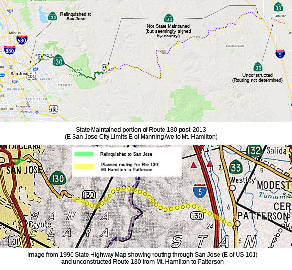 (a) From the eastern city limit of the City of San Jose near Manning Avenue to Route 33
near Patterson via the vicinity of Mount Hamilton.
(a) From the eastern city limit of the City of San Jose near Manning Avenue to Route 33
near Patterson via the vicinity of Mount Hamilton.
(b) The relinquished former portion of Route 130 within the City of San Jose is not a state highway and is not eligible for adoption under Section 81. For the relinquished former portion of Route 130, the City of San Jose shall maintain within its jurisdiction signs directing motorists to the continuation of Route 130 and shall ensure the continuity of traffic flow on the relinquished former portion of Route 130, including any traffic signal progression.
Note: Although Google Maps shows Mt. Hamilton Road, Del Puerco Canyon Road, and Sperry Road as part of Route 130, a check of the state highway GIS database SHN Lines confirms that they are not part of the state highway system. Only the indicated portion within Santa Clara County, from the eastern limit of the City of San Jose to PM 04-SCL-130 22.503, is in the state highway system.
 Post 1964 Signage History
In 1963, this route was defined to run from “Route 101 near San Jose to Patterson via the vicinity of Mount Hamilton.”.
In 1988, Chapter 106 clarified the definition: "Route 101 near
in San Jose to Route 33 near Patterson via the vicinity of
Mount Hamilton."
It appears that one of the past supervisiors (Rodney Diridon) wanted to turn Route 130 into a freeway to link San Jose better with I-5. The freeway would have bypassed the observatory. It would start at I-5 and Del Puerto Canyon Rd, follow Del Puerto Canyon Rd to San Antonio Valley Road, and then veer off to the north towards Route 680 and Route 237 or towards the south towards Quimby Rd or towards Evergreen. This is also been proposed by Rep. Richard Pombo, R-Tracy.
In 2010, Chapter 448 (AB 1670, 9/28/10) renumbered the routing as (a) and added section (b) authorizing the relinquishment of the portion of the route within the city limits of San Jose.
In December 2011, the CTC authorized relinquishment of right of way in the city of San Jose on Route 130 from Route 101 to Millar Avenue, under terms and conditions determined to be in the best interest of the State, as stated in the relinquishment agreement scheduled to be approved by the City at their November 29, 2011 Council Meeting. Authorized by Chapter 448, Statutes of 2010, which amended Section 430 of the Streets and Highways Code.
In 2013, Chapter 525 (SB 788, 10/9/13) updated the definition of Route 130 to reflect relinquishments:
(a) From
Route 101 inthe eastern city limit of San Jose near Manning Avenue to Route 33 near Patterson via the vicinity of Mount Hamilton.(b) The relinquished former portion of Route 130 within the City of San Jose is not a state highway and is not eligible for adoption under Section 81. For the relinquished former portion of Route 130, the City of San Jose shall maintain within its jurisdiction signs directing motorists to the continuation of Route 130 and shall ensure the continuity of traffic flow on the relinquished former portion of Route 130, including any traffic signal progression.
Upon a determination by the commission that it is in the best interests of the state to do so, the commission may, upon terms and conditions approved by it, relinquish to the City of San Jose the portion of Route 130 within the city limits of the City of San Jose if the department and the city enter into an agreement providing for that relinquishment. The following conditions shall apply upon relinquishment:(1) The relinquishment shall become effective on the date following the county recorder's recordation of the relinquishment resolution containing the commission's approval of the terms and conditions of the relinquishment.
(2) On and after the effective date of the relinquishment, the relinquished portion of Route 130 shall cease to be a state highway.
(3) The portion of Route 130 relinquished under this subdivision shall be ineligible for future adoption under Section 81.
(4) The City of San Jose shall ensure the continuity of traffic flow on the relinquished portion of Route 130, including any traffic signal progression.
(5) For the portion of Route 130 that is relinquished under this subdivision, the City of San Jose shall install and maintain within the jurisdiction of the city signs directing motorists to the continuation of Route 130.
As of February 2018, it was reported that there is no longer any
reference to Route 130 from US 101; all the original button-copy signs
dating from the 1990s featuring Route 130 shields have been replaced by
bright green reflective-sheeting sign material; the advance and exit signs
now read "Santa Clara Street/Alum Rock Avenue", sans any shields. This
makes Route 130 is now officially and functionally an "orphan" on Mt.
Hamilton Road. There was never any signage at I-680, save for the
post-mile stenciling on the overpass at Alum Rock.
(Source: Scott Parker (Sparker) on AARoads, 2/19/2018)
 Pre 1964 Signage History
This was LRN 115; and appears to have not been signed before 1963. The portion between Route 101 and Mount Hamilton was defined in 1933; the remainder was defined in 1961.
Signed Route 130 was not defined as part of the initial state signage of routes in 1934. It is unclear what (if any) route was signed as Route 130 between 1934 and 1964.
 Status
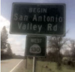 Field reports indicate that signage of the route E of Mt.
Hamilton is performed by the county, not the state. It also appears the
route is maintained by the county between Mt. Hamilton and Patterson. This
is based on physical verification, not Caltrans information. Reports
indicate that Route 130 has the usual green miner's spade sign till you
reach the observatory, then after that it has a white miner's spade (with
green numbers) printed on a large green rectangular sign until you reach
Stanislaus County (see the picture to the right taken by Carl Rogers).
Between the Lick Observatory and the county line, Santa Clara County
Department of Roads and Airports seems to be in charge of maintenance. All
barricades along the routing mention the department. It is totally
unsigned in Stanislaus County. Officially, the route is undetermined from
Mt. Hamilton to Route 33 near Patterson.
Field reports indicate that signage of the route E of Mt.
Hamilton is performed by the county, not the state. It also appears the
route is maintained by the county between Mt. Hamilton and Patterson. This
is based on physical verification, not Caltrans information. Reports
indicate that Route 130 has the usual green miner's spade sign till you
reach the observatory, then after that it has a white miner's spade (with
green numbers) printed on a large green rectangular sign until you reach
Stanislaus County (see the picture to the right taken by Carl Rogers).
Between the Lick Observatory and the county line, Santa Clara County
Department of Roads and Airports seems to be in charge of maintenance. All
barricades along the routing mention the department. It is totally
unsigned in Stanislaus County. Officially, the route is undetermined from
Mt. Hamilton to Route 33 near Patterson.
According to the Traversable Routing report, the traversable routing from Mt. Hamilton to the Stanislaus County line is along San Antonio Valley Road and Del Puerto Canyon Road. This routing is substandard, and no improvements are anticipated. E of the Stanislaus County Line, there are no plans and no recommendations. Between the county line and I-5, the closest routing is Del Puerto Canyon Road.
The 2013 Traversable Highway report indicated that the following segment is Category 3 — The traversable highway is inadequate or nonexistent, but project studies are scheduled within five years so State assumption of maintenance is a possibility within the next ten years: Santa Clara County Line to Route 5 (Del Puerto Canyon Road) (23 mi). It also notes that from Mt. Hamilton to Route 33, the closest routing is San Antonio Valley Road and Del Puerto Canyon Road. Existing roads are not to State standard. The route segment within the city of San Jose was relinquished.
Pombo's Folly
The SAFETEA-LU act, enacted in August 2005 as the reauthorization of TEA-21, provided the following expenditures on or near this route:
There were also some proposals to build a new parallel highway to bypass the Alamont Pass. Specifically, a proposal made by former Congressman Richard Pombo (R-Tracy) that would hvae connected Route 130 and I-5. The San Jose Mercury News published an article showing cost estimates for this in the $10 billion range, and projected tolls around $25-50 per trip. This reached the study phase, with $2 million funding in the 2005 Transportation Bill for a study of a possible new highway over the Diablo Range in California (I-680 in San Jose to I-5 in Patterson/Central Valley). Some of the problems with this routing included (a) very rugged country with mountain ranges that run perpendicular to the proposed route; (b) peaks over 4,000 feet; (c) a very rural area, with cattle ranches, a few houses, boy scout camps, state and county parks, and much wildlife (read: expensive environmental impacts); and (d) presence of the Lick Observatory, which is very sensitive to light pollution.
The East Bay Express had an interesting article on this. It noted that in 2003, Rep. Richard Pombo proposed that Route 130 be replaced with a six-lane, cars-only freeway that would start at I-5, just west of Patterson in Stanislaus County. It would then run the traditional route of Route 130, following the narrow, twisting path of Del Puerto Canyon Road and connecting with San Antonio Valley Road. It would traverse Mount Hamilton, past the Lick Observatory, before finally ending in East San Jose at I-680. Today the entire 63-mile trip takes about three hours, and contains a minimum of 365 switchbacks. This new freeway would cut through a large segment of a rugged, 150-mile-long mountain range where no natural pass exists. According to the article, the remote countryside between Silicon Valley and the Central Valley is one of the best-kept secrets in the Bay Area and provides a dizzying array of hills, mountains, and valleys, with rolling grasslands and pine-covered peaks studded with oaks and cattle ranches and teeming with wildlife: rattlesnakes, eagles, bobcats, tule elk, red- tailed hawks, and mountain lions. It is also habitat for endangered and threatened species, such as the bay checkerspot butterfly, the California red-legged frog, and, of course, the San Joaquin kit fox. It is noted that speculation about the possible new freeway drove up the value of the 205-acre ranch Pombo owns in south Tracy with his parents and brothers; this property sits right on I-580.
However, the article noted that Pombo was looking to move Route 130 farther north, closer to Tracy. The specific routing was unknown, but it was believed that the new freeway might parallel I-580, just south of the Altamont Pass, and slice through the wine country of southern Livermore and southern Pleasanton before linking up with I-680 north of Sunol. This is less rugged than the original proposed route, would not be so expensive, and would wreak far less environmental damage. It also fits with the SAFETEA-LU wording. The East Bay Express article noted that if the freeway is moved north, it would be much closer to Pombo's property, thereby adding even more value to it.
Pombo's defeat in the elections of 2006, however, killed the proposals for this road.
 National Trails
 This route is part of the De Anza National Historic Trail.
 Other WWW Links
 Statistics
Overall statistics for Route 130:
 Pre-1964 Legislative Route
In 1933, Chapter 767 defined the route from "Orosi to Bakersfield-General Grant Park Road" as a state highway. This was codified into the highway code as LRN 130, with the definition:
“Orosi to [LRN 129]”
This is the routing from Orosi to Route 65 (present-day Route 245). It would appear to run along Avenue 416 and Road 168. This is a former segment of Route 63 that was deleted in 1965, when former Route 226 was added to Route 63. LRN 130 is now Tulare County Sign Route J40.
© 1996-2020 Daniel P. Faigin.
Maintained by: Daniel P. Faigin
<webmaster@cahighways.org>.
 Route 129
 Route 131