
 California Highways:
Click here for a key to the symbols used. An explanation of acronyms may be found at the bottom of the page.
 Routing
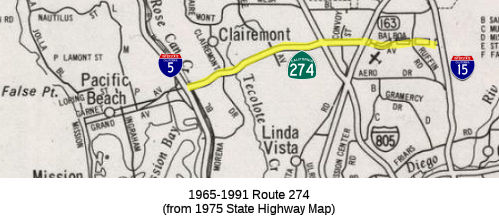 No current routing. Field reports indicate that the old routing is still
signed. The old routing was relinquished in June 2001.
No current routing. Field reports indicate that the old routing is still
signed. The old routing was relinquished in June 2001.
 Post 1964 Signage History
 In 1965, Chapter 2068 defined Route 274 as “Route 5 near
Balboa Avenue to Route 103.”
In 1969, Chapter 294 changed "Route 103" to "Route 15".
During 1971, Route 274 was completed to state highway standards between
I-5 and I-805. By 1975, Route 274 was a complete highway between I-5
and Route 163, with an adopting routing east to I-15 (as shown on the map
to the right). Route 274 was completed to I-15 by 1990.
(Source: Gribblenation Blog (Tom Fearer), "Former California State Route 274", 11/3/2023)
The routing was deleted in 1999 by AB 1650, Ch 724, 10/10/99. It still shows up in the CalTrans photologs in 2001, and a few signs remain. It was once signed as BR US 101.
As signs get replaced on I-5, references to Route 274 are disappearing; however, Route 274 is still well marked upon Balboa.
 Pre 1964 Signage History
Originally (i.e., circa 193), Balboa Avenue was a major locally
maintained road from Grand Avenue in the San Diego neighborhood of Pacific
Beach east to Morena Boulevard. Balboa Avenue as originally
configured intersected US 101 (LRN 2) at what is now Mission Bay Drive
(then Grand Avenue). By 1958, it had been extended E into the Clairemont
neighborhood. Balboa Avenue was not part of the state highway system
before 1965.
(Source: Gribblenation Blog (Tom Fearer), "Former California State Route 274", 11/3/2023)
 Other WWW Links
 Statistics
Overall statistics for Route 274:
 Pre-1964 Legislative Route
In 1959, Chapter 1062 defined LRN 274 as “[LRN 77] near Chino to [LRN 190] near Upland”. This is the part of present-day proposed Route 142 from Route 71 near Chino to I-210 (nee Route 30) near Upland.
© 1996-2020 Daniel P. Faigin.
Maintained by: Daniel P. Faigin
<webmaster@cahighways.org>.
 Route 273
 Route 275