
 California Highways:
Click here for a key to the symbols used. An explanation of acronyms may be found at the bottom of the page.
 Routing
 Post 1964 Signage History
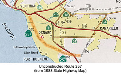
In 1965, Chapter 1372 defined Route 257 as "Route 34 to Route 101 near Ventura."
Scott Parker on AARoads noted: There was neither any adopted nor existing
alignment for unbuilt Route 257; its general E-W section was well south of
the 5th street extension that runs along the Metrolink tracks as part of
Route 34. From the draft maps of the time, Route 257 terminated at the
then-future Route 34 alignment a couple of miles north of Route 1 north of
Point Mugu, crossing Route 1's alignment near where the through route
currently veers north onto Rice Avenue, continuing WNW from there to Port
Hueneme before turning to parallel the coast before terminating at US 101
east of central Ventura between the Route 126 and Route 33 interchanges.
Clearly Route 257 was a "developmental" road, intended to serve the
housing developments south of Camarillo as well as the coastal
recreational area between Hueneme and Ventura. The likelihood of that road
ever being built are very, very slim and none.
(Source: Scott Parker on AARoads, "Re: CA 34", 11/9/2019)
 Pre 1964 Signage History
This route was not defined in the state highway system before 1963.
 Status
 This routing is unconstructed. This routing was planned as freeway; it was never upgraded. The traversable route is 5th Street and
Harbor Blvd west of Route 1. It is a circuitous route around Plaza Park in
Oxnard. Caltrans has no plans to adopt this route.
According to the 2013 Traversable Highways report, the route is circuitous around Plaza Park in Oxnard using 5th St., Harbor Blvd. No plans to adopt.
 Freeway
[SHC 253.1] Entire route. Added to the Freeway and Expressway system in 1965.
 Statistics
Overall statistics for Route 257:
 Pre-1964 Legislative Route
In 1959, Chapter 1062 defined LRN 257 as “[LRN 69] near West Grand Avenue in Oakland to [LRN 69] near Albany.” This is part of present-day Route 61.
© 1996-2020 Daniel P. Faigin.
Maintained by: Daniel P. Faigin
<webmaster@cahighways.org>.
 FromRoute
  Route 256
 Route 258