
 California Highways:
Click here for a key to the symbols used. An explanation of acronyms may be found at the bottom of the page.
 Routing
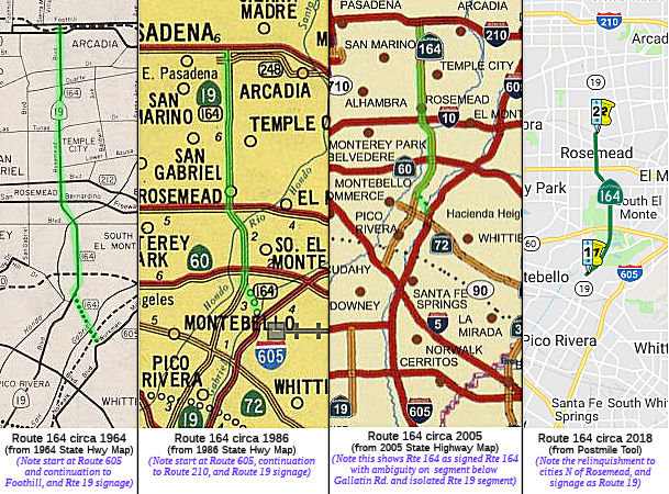 (a) Rosemead Blvd from:
(1) Gallatin Road near Pico Rivera to the southern city limit of South El Monte in the vicinity of Rush Street.
(2) The southern city limit of South El Monte in the vicinity of Rush Street to the southern city limit of El Monte in the vicinity of the Rio Hondo River.
(3) The southern city limit of El Monte in the vicinity of the Rio Hondo River to the southern city limit of Temple City in the vicinity of Grand Avenue
(4) Route 210 to Foothill Boulevard in the City of Pasadena.
(b) The relinquished former portions of Route 164 within the County of Los Angeles and the City of Temple City are not state highways and are not eligible for adoption under Section 81. For the relinquished former portions of Route 164, the County of Los Angeles and the City of Temple City shall maintain within their respective jurisdictions signs directing motorists to the continuation of Route 164.
(c) (1) Notwithstanding subdivision (a), the commission may relinquish to the County of Los Angeles that portion of Route 164 described in paragraph (1) of subdivision (a), pursuant to the terms of a cooperative agreement between the county and the department, upon a determination by the commission that the relinquishment is in the best interests of the state.
(2) A relinquishment under this subdivision shall become effective immediately following the recordation by the county recorder of the relinquishment resolution containing the commission’s approval of the terms and conditions of the relinquishment.
(3) On and after the effective date of the relinquishment, both of the following shall apply:
(A) The portion of Route 164 relinquished under this subdivision shall cease to be a state highway.
(B) The portion of Route 164 relinquished under this subdivision may not be considered for future adoption under Section 81.
(4) For the portion of Route 164 that is relinquished under this subdivision, the County of Los Angeles shall maintain within its jurisdiction signs directing motorists to the continuation of Route 164.
(d) (1) Notwithstanding subdivision (a), the commission may relinquish to the City of South El Monte that portion of Route 164 described in paragraph (2) of subdivision (a), pursuant to the terms of a cooperative agreement between the city and the department, upon a determination by the commission that the relinquishment is in the best interests of the state.
(2) A relinquishment under this subdivision shall become effective immediately following the recordation by the county recorder of the relinquishment resolution containing the commission’s approval of the terms and conditions of the relinquishment.
(3) On and after the effective date of the relinquishment, both of the following shall apply:
(A) The portion of Route 164 relinquished under this subdivision shall cease to be a state highway.
(B) The portion of Route 164 relinquished under this subdivision may not be considered for future adoption under Section 81.
(4) For the portion of Route 164 that is relinquished under this subdivision, the City of South El Monte shall maintain within its jurisdiction signs directing motorists to the continuation of Route 164.
 Post 1964 Signage History
As defined in 1963, this route ran from "Route 605 near Pico Rivera to Route 210 near Pasadena." Planned as freeway in 1965. This is signed as Route 19 via Rosemead Blvd. The segment started at Route 605 and ran along Gallatin Road (now Beverly Blvd) to Rosemead Blvd, where it turned N. Note that one of the Foothill Freeway bridges has a marker indicating that it's the 210/164 separation. Another marker stating that that portion of "164" is signed on a white card on Route 60 in Whittier Narrows Park. The Calnexus site also indicates Rosemead Blvd as Route 164.
According to Scott Parker on AARoads, Route 164 was to be a stand-alone
sub-regional freeway (variously called the "Rosemead", "Santa Anita", and
"Sierra Madre" freeways. It was to effectively subsume the northern
portion of (then) Signed Route 19 north of the Whittier Narrows; it would
have terminated at I-605 north of the Beverly Blvd. exit and headed
northwest near the Narrows dam, coming close to Rosemead Blvd just south
of Route 60. It was intended to serve as a "cutoff" from I-605 to
Pasadena. There was never any intent to extend it further south
along Route 19; south of Whittier Narrows it was always intended to remain
a surface facility. Within the scope of the 1964 renumbering the
Division of Highways elected to make the whole freeway corridor one
individual route; it was subsequently assigned the number 164.
Apparently there was no intention of ever signing 164 until such time as
the freeway was (a) adopted and (b) constructed -- neither of which ever
happened. So why are the Route 164 signs? In 1969, when District 7
(which included Orange County at the time) was busy installing shields on
any and all facilities under their aegis, some signage crew took the
number 164 literally and manufactured and erected a limited number of
small/medium green signs with a Route 164 spade in place of Route 19;
these were deployed on the collector/distributor roads at the
I-10/Rosemead cloverleaf as well as at the foot of the Rosemead ramps on
Route 60. The 164-shielded green signs on the Route 60 ramps were
gone by late 1970, while the ones on I-10 hung around for at least another
year and a half. Eventually all were replaced by Route 19 signs,
since that was the signed route at the time.
(Source: Scott Parker on AARoads, "Re: California SR 19 (Rosemead Blvd.; Lakewood Blvd.)", 7/26/2020)
SB 1375, Chapter 396, September 9, 2004, changed the definition from the nebulous "From Route 605 near Pico Rivera to Route 210 near Pasadena" to specifically be "Rosemead Boulevard from: (1) Gallatin Road near Pico Rivera to the northern city limit of Temple City in the vicinity of Callita Street and Sultana Avenue. (2) The northern city limit of Temple City in the vicinity of Callita Street and Sultana Avenue to the southern city limit of the City of Pasadena. SB 1375 explicitly permits relinquishment to the County of Los Angeles that portion of Route 164 described as (2) pursuant to the terms of a cooperative agreement between the county and the department, upon a determination by the commission that the relinquishment is in the best interests of the state. Said relinquishment becomes effective immediately following the recordation by the county recorder of the relinquishment resolution containing the commission's approval of the terms and conditions of the relinquishment; at that point, the relinquished portion of Route 164 ceases to be a state highway, and cannot be considered for future readoption. Further, the County of Los Angeles shall maintain within its jurisdiction signs directing motorists to the continuation of Route 164." This was relinquished in October 2006.
SB 910, Chapter 218, chaptered September 21, 2007, authorized the relinquishment of the portion in the City of Temple City to that city subject to the approval of the CTC. The relinquishment becomes effective immediately following the recordation by the county recorder of the relinquishment resolution containing the commission's approval of the terms and conditions of the relinquishment. On and after the effective date of the relinquishment, the portion of Route 164 relinquished ceases to be a state highway, and cannot be considered for future adoption as a state highway. Additionally, the City of Temple City is required to maintain within its jurisdiction signs directing motorists to the continuation of Route 164.
In 2010, Chapter 421, 9/29/10, SB 1318 changed the second part of the
definition: "(2) Route 210 The northern city limit of Temple
City in the vicinity of Callita Street and Sultana Avenue to Foothill
Boulevard
in the southern city limit of the City of Pasadena."
In 2015, Chapter 575 (2015), SB 461, 10/07/15 authorized relinquishment of specified portions of Route 164 to the County of Los Angeles and to the City of South El Monte by changing the definition as follows:
(a) Rosemead Blvd from:
(1) Gallatin Road near Pico Rivera to the southern city limit of South El Monte in the vicinity of Rush Street.
(2) The southern city limit of South El Monte in the vicinity of Rush Street to the southern city limit of El Monte in the vicinity of the Rio Hondo River.
(3) The southern city limit of El Monte in the vicinity of the Rio Hondo River to the southern
northerncity limit of Temple City in the vicinity of Grand Avenuein the vicinity of Callita Street and Sultana Avenue,(4
2) Route 210 to Foothill Boulevard in the City of Pasadena.
Chapter 575 (2015) also added:
(c) (1) Notwithstanding subdivision (a), the commission may relinquish to the County of Los Angeles that portion of Route 164 described in paragraph (1) of subdivision (a), pursuant to the terms of a cooperative agreement between the county and the department, upon a determination by the commission that the relinquishment is in the best interests of the state.
(2) A relinquishment under this subdivision shall become effective immediately following the recordation by the county recorder of the relinquishment resolution containing the commission’s approval of the terms and conditions of the relinquishment.
(3) On and after the effective date of the relinquishment, both of the following shall apply:
(A) The portion of Route 164 relinquished under this subdivision shall cease to be a state highway.
(B) The portion of Route 164 relinquished under this subdivision may not be considered for future adoption under Section 81.
(4) For the portion of Route 164 that is relinquished under this subdivision, the County of Los Angeles shall maintain within its jurisdiction signs directing motorists to the continuation of Route 164.
(d) (1) Notwithstanding subdivision (a), the commission may relinquish to the City of South El Monte that portion of Route 164 described in paragraph (2) of subdivision (a), pursuant to the terms of a cooperative agreement between the city and the department, upon a determination by the commission that the relinquishment is in the best interests of the state.
(2) A relinquishment under this subdivision shall become effective immediately following the recordation by the county recorder of the relinquishment resolution containing the commission’s approval of the terms and conditions of the relinquishment.
(3) On and after the effective date of the relinquishment, both of the following shall apply:
(A) The portion of Route 164 relinquished under this subdivision shall cease to be a state highway.
(B) The portion of Route 164 relinquished under this subdivision may not be considered for future adoption under Section 81.
(4) For the portion of Route 164 that is relinquished under this subdivision, the City of South El Monte shall maintain within its jurisdiction signs directing motorists to the continuation of Route 164.
In July 2020, a commentator on AAroads noted that there is less than four
total miles of Route 164 remaining under state maintenance, broken into
three disconnected segments. Scott Parker noted that the discontiguous
500' segment N of I-210 "is a leftover from the original LRN 168
alignment, which terminated at Foothill Blvd. (old LRN 9) rather than
Colorado Blvd. (old LRN 161/US 66) a couple of blocks south.
Apparently it still is inventoried to ensure partial state funding for the
maintenance of the Gold Line transit bridge over Rosemead, situated in the
median of I-210 -- itself a "legacy" bridge from the old Santa Fe Pasadena
line days (I-210 was originally built straddling those tracks)."
(Source: Scott Parker on AARoads, "Re: California SR 19 (Rosemead Blvd.; Lakewood Blvd.)", 7/29/2020)
 Pre 1964 Signage History
This was a proposed routing as of 1963. It was LRN 271, defined in 1959, between the proposed I-605 routing (LRN 170) and Rosemead Blvd (Route 19; LRN 168), and LRN 168, defined in 1933, from Rosemead Blvd N to Route 9 (US 66; future I-210) near Arcadia. The approximate routing was along Whittier and Rosemead Blvds.
One 1939 map shows Route 164 as being signed along present-day Route 107, which was LRN 164. Route 164 was not defined in the 1934 initial set of state signed routes.
 Status
 Unconstructed from Route 605 to Route 19 (Rosemead Blvd). May
be signed as Route 19 from Route 19 to Route 210.
Unconstructed from Route 605 to Route 19 (Rosemead Blvd). May
be signed as Route 19 from Route 19 to Route 210.
The 2013 Traversable Highways report indicates this is unconstructed from Route 605 to Gallantin Road (via Beverly Blvd now). The road is probably adequate.
Route 164 in Pico Rivera (former LA 0.000 to LA 1.402)
The SAFETEA-LU act, enacted in August 2005 as the reauthorization of TEA-21, provided the following expenditures on or near this route:
Route 164 in LA County (LA 1.402 to LA 3.951)
The following project was included in the final adopted 2018 SHOPP in March 2018: PPNO 5193. 07-Los Angeles-164 1.4/4.0. In and near South El Monte, on Rosemead Boulevard (Route 164) from Gallatin
Road to Rush Street. Relinquishment Financial Contribution Only (FCO) to
the county of Los Angeles. Begin Con: 4/30/2018. Total Project Cost:
$1,500K. In June 2018, the CTC authorized relinquishment of right of way
in the county of Los Angeles (County) on Route 164 (Rosemead Boulevard)
between Gallatin Road and 0.08 mile south of Rush Street (07-LA-164-PM
1.4/4.0), under terms and conditions as stated in the relinquishment
agreement dated May 15, 2018, determined to be in the best interest of the
State. Authorized by Chapter 575, Statutes of 2015, which amended Section
464 of the Streets and Highways Code.
(Source: final adopted 2018 SHOPP; CTC Agenda, June2018
Agenda Item 2.3c)
The segment between Route 60 and I-10 (LA County, South El Monte, and Rosemead) in South El Monte is freeway-like, where the left 2 lanes are concrete, the right lane asphalt, speed limit 50, and an exit/entrance ramp just before I-10 at Telstar Ave (164 LA 5.299) with a south entrance off of Ramona Road in El Monte. This observation was made by "LA FREEWAY ENTHUSIAST".
Route 164 in South El Monte (~LA 3.951 to LA 4.906)
In December 2020, the CTC amended the 2020 SHOPP to add/revise the
following project as indicated: 07-LA-164 PM 1.4/6.9 4.0/6.9
PPNO 07-4982 ProjID 0716000042 EA 32080. Route 164 In the cities of Whittier,
South El Monte, El Monte, and
Rosemead, and Temple City, from Gallatin Road Rush
Street to Rudell Underpass. Upgrade curb ramps, sidewalks and
pathways to meet current Americans with Disabilities Act (ADA) standards.
Programmed funding changes (in thousands): Con Sup $2,714
$2,000; R/W Cap $952 $720;
Const Cap $5,803 $5,626; Total $14,569
$13,446. Explanation: Change to postmile limits due to
a partial relinquishment of Route 164. Update of
performance measure because some curb ramps were removed from the
relinquished segment, and some remaining curb ramps were changed from one
corner curb ramp to two directional ramps. Construction support, R/W
capital, and construction capital were updated to reflect the revised
project limits and updated survey mapping. Note:
This reflects the change from the 2018 SHOPP that relinquished Route 164
from Gallatin Road to Rush Street, 07-LA-164 1.4/4.0.
(Source: December 2020 CTC Agenda, Agenda Item
2.1a.(1d) #13)
Route 164 in Rosemead (~ LA 4.906 to LA 6.89)
Note: This is joint with El Monte between LA 4.904 and LA 5.564, with the W side in Rosemead, and the E side in El Monte.
The SAFETEA-LU act, enacted in August 2005 as the reauthorization of TEA-21, provided the following expenditures on or near this route:
Route 164 in Temple City (former 7-LA-164-PM 6.9/8.8)
The SAFETEA-LU act, enacted in August 2005 as the reauthorization of TEA-21, provided the following expenditures on or near this route:
In February 2013, it was reported that groundbreaking for the Rosemead Blvd Enhancement project would be on March 1, 2013. The Rosemead Boulevard Enhancement Project is a streetscape redesign effort by the City of Temple City, dedicated to improving traffic safety, reenergizing one of the city’s main commercial corridors and creating a vibrant community destination. Through physical improvements and beautification elements like new sidewalks, added canopy trees and public art; as well as incoming amenities like outdoor dining and bike lanes, this Project is set to transform the two-mile stretch of Rosemead Boulevard within Temple City from an auto-oriented pass-through thoroughfare, into an attractive place for community life. (Note: This is actually closer to Route 164)
In April 2008, the CTC authorized relinquishment of right of way in the city of Temple City, under terms and conditions as stated in the cooperative agreement, dated March 18, 2008, determined to be in the best interest of the State. Authorized by Chapter 218, Statutes of 2007, which amended Section 464 of the Streets and Highways Code.
Route 164 in Los Angeles (LA 8.8 to LA 11.0)
Relinquishment in Los Angeles (LA 8.8 to LA 11.0)
In September 2006, the CTC considered relinquishment of right of way in the City of Los Angeles, on Rosemead Boulevard, from Callita Street and Sultana Avenue to Foothill Boulevard. [7-LA-164-PM 8.8/11.0]
On October 27, 2006, the relinquished portion of roadway was formally turned over to the County of Los Angeles on October 27, 2006. The county plans to do road resurfacing, landscaping improvements, and utility undergrounding. The medians have already been weeded and some resurfacing has begun. The estimated cost for rehabilitation is $20 million. The portion of Rosemead Boulevard in Temple City and El Monte remains a state highway.
 Naming
The proposed name for this freeway was the "Rio Hondo Freeway". Rio Hondo refers to a river that runs near the route. In 1867, the San Gabriel River changed its course, and the old channel became known as the Rio Hondo.
 Freeway
[SHC 253.1] Entire route (unconstructed). Added to the Freeway and Expressway system in 1959.
 Other WWW Links
 Statistics
Overall statistics for Route 164:
 Pre-1964 Legislative Route
In 1933, Chapter 767 added the route "[LRN 60] at Torrance via Hawthorne Avenue to Mines Field-San Fernando Road" to the highway system. In 1935, it was added to the highway code with the following routing:
In 1957, Chapter 1911 clarified the routing to: "[LRN 60] near at
Torrance via Hawthorne Avenue to [LRN 158] near
Culver City".
This route ran from Route 1 near Torrance to former Route 7 (I-405) near Culver City. This is Route 107. It ran along Hawthorne and La Brea to Centinela, then along Centinela to Sepulveda Blvd.
© 1996-2020 Daniel P. Faigin.
Maintained by: Daniel P. Faigin
<webmaster@cahighways.org>.
 Route 163
 Route 165