
 California Highways:
Click here for a key to the symbols used. An explanation of acronyms may be found at the bottom of the page.
 Routing
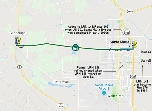 From Route 1 near Guadalupe to Route 101 in Santa Maria.
 Post 1964 Signage History
This segment remains as defined in 1963.
 Pre 1964 Signage History
This was originally part of LRN 148, defined in 1933.
 Status
In January 2024, it was reported that Caltrans was holding public
information meetings to present details of the Downtown Guadalupe Sidewalk
Repair and Replacement Project, Santa Maria River Bridge Replacement
Project, and several other projects in the Guadalupe area. One of these
projects is titled "Highway 1/State Route 166 Intersection Improvements".
The specifics of the project (EA 05-1F290) are skant: It is at the
intersection of Route 1 and Route 166, east on Main St. just short of
Flower Ave (05-SB-166 0.0/0.3). The work is described as interchange
improvements. It is currently in the PA&ED (Environmental
Documentation Phase) stage. It planned for construction 6/2024 - 8/2025
with a construction capital of $3,000,000. However, the project does not
appear to be in the SHOPP or the project book.
(Source: Santa Maria Times, 1/16/2024)
 Naming
 Designates the portion of Route 166 from Simas Road to Bonita School Road in the
County of Santa Barbara (~ SB 0.864 to SB 3.746), E of Guadalupe, as the "Officer
Samuel Sanchez Memorial Highway" (signed as "Guadalupe Officer
Samuel Sanchez Memorial Highway"). Named in memory of Guadalupe
Police Officer Samuel Sanchez, who was born in April 1944, into a large
California native family of nine children, with six of his siblings in law
enforcement. Sanchez was sworn into the Guadalupe Police Department on
November 11, 1965, and served the City of Guadalupe for four years
alongside his brother, Elias Sanchez. On April 13, 1969, while
transporting three prisoners to jail, Officer Sanchez was killed in a
head-on collision with a driver under the influence on Route 166. Named by
Senate Concurrent Resolution (SCR) 12, Res. Chapter 106, Statutes of 2015,
on July 16, 2015.
Designates the portion of Route 166 from Simas Road to Bonita School Road in the
County of Santa Barbara (~ SB 0.864 to SB 3.746), E of Guadalupe, as the "Officer
Samuel Sanchez Memorial Highway" (signed as "Guadalupe Officer
Samuel Sanchez Memorial Highway"). Named in memory of Guadalupe
Police Officer Samuel Sanchez, who was born in April 1944, into a large
California native family of nine children, with six of his siblings in law
enforcement. Sanchez was sworn into the Guadalupe Police Department on
November 11, 1965, and served the City of Guadalupe for four years
alongside his brother, Elias Sanchez. On April 13, 1969, while
transporting three prisoners to jail, Officer Sanchez was killed in a
head-on collision with a driver under the influence on Route 166. Named by
Senate Concurrent Resolution (SCR) 12, Res. Chapter 106, Statutes of 2015,
on July 16, 2015.
(Image source: Noozhawk; Officer Down Memorial Page)
"Main" Street in Santa Maria (~ SB 6.512 to SB 8.87).
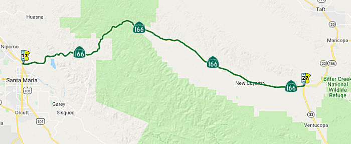 From Route 101 near Santa Maria to Route 33 in Cuyama Valley.
Post 1964 Signage HistoryThis segment remains as defined in 1963.
Pre 1964 Signage HistoryIn 1934, Route 166 was signed along the route from Jct. Route 1 at Guadalupe to Jct. US 99 S of Bakersfield via Maricopa. It was part of LRN 57, defined in 1919.
 In 1956, the California Highway Commission adopted a new
routing for Route 166 for 7.8 mi between 1 mi. W of the Husana River (~
SLO 15.512) and 0.6 mi W of Buckhorn Creek (~ SB 23.335), with another 5.1
mi section between a point ½ mi W of Deadman's Gulch and Cuyama
Maintenance Station, E of Aliso Creek, in Santa Barbara County. The
existing highway on the S side of the Cuyama River will be replaced by a
higher level two-lane highway on the N side. The relocated area generally
parallels the existing road from W of the Husana River to about 1 mi E of
Alamo Creek. This relocation was brought about through the planned
construction of Vaquero Dam (later renamed the Twitchell Reservoir) by the US Reclamation Bureau.
In 1956, the California Highway Commission adopted a new
routing for Route 166 for 7.8 mi between 1 mi. W of the Husana River (~
SLO 15.512) and 0.6 mi W of Buckhorn Creek (~ SB 23.335), with another 5.1
mi section between a point ½ mi W of Deadman's Gulch and Cuyama
Maintenance Station, E of Aliso Creek, in Santa Barbara County. The
existing highway on the S side of the Cuyama River will be replaced by a
higher level two-lane highway on the N side. The relocated area generally
parallels the existing road from W of the Husana River to about 1 mi E of
Alamo Creek. This relocation was brought about through the planned
construction of Vaquero Dam (later renamed the Twitchell Reservoir) by the US Reclamation Bureau.
(Source: Arroyo Grande Valley Herald Recorder, 6/29/1956 via Joel
Windmiller, 1/27/2023)
StatusNote: In this segment, Route 166 meanders between Santa Barbara and SLO Counties.
In May 2011, the CTC approved for future consideration of funding a project that will realign Route 166 from just west of Carrizo Canyon Bridge to just east of Cuyama River Bridge (~ W of Bridge 49-0041, SLO 044.26 to E of Bridge 49-0043, SLO R051.02). The project is programmed in the 2010 State Highway Operation and Protection Program. Construction is estimated to begin in Fiscal Year 2011- 12. Total estimated project cost is $6,477,000 for capital and support. The scope as described for the preferred alternative is consistent with the project scope programmed by the Commission in the 2010 State Highway Operation and Protection Program. A copy of the ND has been provided to Commission staff. Due to potential impacts to visual resources, an Initial Study was completed for the project. Potential visual impacts will be reduced by replacing removed trees at a 10:1 ratio. New trees will be planted in clusters and will be monitored for at least one year. Based upon environmental studies and proposed environmental commitments, the project will not have a significant effect on the environment.
In October 2011, the CTC approved $335,000 to construct 6½ miles of centerline rumble strips near New Cuyama (~ SB 65.459).
In October 2018, it was reported that residents of Cuyama Valley (~ SB
68.767) have come together as a united force for a common goal — to
improve safety on Route 166, where they say traffic has increased and with
it the risk of deadly crashes. Residents say the increase in traffic has
taken place over the last 10 months, and they believe it’s an
indirect impact from the 1/9/2018 Debris Flow in Montecito on Route 192.
To gain some leverage, the residents are using the Cuyama Valley Community
Association to drive a petition asking Caltrans and the California Highway
Patrol for two improvements they believe would make it safer to drive the
highway. Directed to the CHP’s Route 166 Taskforce, the petition
asks for signs to be installed along the highway to notify drivers where
turnouts are located and urging motorists to be courteous and use them.
Installing the signs would be Caltrans’ responsibility. However,
Caltrans would probably require that any marked turnouts be paved;
although there are a number of level, gravel-covered turnouts along both
sides of the highway, none have been paved with asphalt. The petition also
asks the CHP to assign at least one officer to patrol Route 166 full time.
The problem with having a unit patrol Route 166 full time is the limited
number of officers allocated to the Santa Maria Area, which is ultimately
determined by state funding. When the January 2018 debris flow in
Montecito shut down Route 101 for 10 days, Route 166 was one of the routes
initially promoted as an alternative for northbound Southern California
motorists to reach coastal destinations beyond Santa Barbara. Cuyama
Valley residents say during that 10-day period, Southern California
drivers “discovered” Route 166, and after US 101 reopened,
many of them continued to use the often winding, two-lane highway as their
route of choice. The result is an increase not only in traffic but also in
the number of crashes, near misses and speeders on the highway, making it
more dangerous for those passing through as well as locals. Although the
speed limit is 55, drivers have been clocked as fast as 105.
(Source: Santa Maria Times, 10/19/2018)
Naming This segment (~ SLO 8.976 to SLO 74.638) is named the "CHP Officers Irvine and Stovall
Memorial Highway". California Highway Patrol Officers Britt T.
Irvine and Rick B. Stovall died on the early morning of February 24, 1998
when their patrol unit plunged off the eastbound lane of Route 166 which
had been washed out by heavy rains. Named by Senate Concurrent Resolution
79, Chapter 65, in 1998.
This segment (~ SLO 8.976 to SLO 74.638) is named the "CHP Officers Irvine and Stovall
Memorial Highway". California Highway Patrol Officers Britt T.
Irvine and Rick B. Stovall died on the early morning of February 24, 1998
when their patrol unit plunged off the eastbound lane of Route 166 which
had been washed out by heavy rains. Named by Senate Concurrent Resolution
79, Chapter 65, in 1998.
(Image source: California 166 on Geocities; CHP Memorial Page (Irvine); CHP Memorial Page (Stovall))
More details on Stovall and Irvine were
contained in an article exploring what happened to their roadside
memorial. On Feb. 24, 1998, a deluge of rain turned the Cuyama River into
a raging monster as the swift-moving channel washed out a large chunk of
Route 166. In the middle of the night, Santa Maria-based California
Highway Patrol Officers Rick Stovall and Britt Irvine were responding to
reports of motorists in distress and drove off the missing segment of
roadway. In addition to the officers, a Nipomo man died; his body was
never recovered. Two other men were lucky to be rescued. For years, a
large cross and other mementos sat at the spot as well-maintained
memorials to the CHP officers. Details about the fate of the
Irvine-Stovall roadside memorials remain uncertain, although in 2003
Caltrans announced plans to remove them. According to Caltrans policy, the
memorials/items would be held at the nearest Caltrans maintenance facility
if there is a wish to retrieve it.
(Source: SB Noozhawk, 6/17/2018)
 Named Structures
 Bridge 49-0178, over the Huasna River (SLO016.45) in San Luis Obispo county, is named the "Senator
John J. Hollister Memorial Bridge". It was built in 1962, and named
by Senate Concurrent Resolution 25, Chapter 40, in the same year. John
Hollister was born in the old Hollister Adobe to an early Santa Barbara
cattleman and his wife. His early education was at the Dean School in
Santa Barbara, with later education at the Groton School in Massachusetts
and Harvard University, where he graduated in 1925 with an AB degree in
Economics, principally in the field of Agricultural Economics. Returning
to California, he worked at Spreckles Bank in San Francisco and was
engaged in the securities business until 1932. From 1932 to 1955, Jack was
actively in charge of the Winchester Ranch of the Hollister Estate Company
in Santa Barbara County. Jack was elected to the California State Senate
in 1955 during a special election and was re-elected in 1956 and 1960.
During his terms of office, he manifested a keen interest in legislation
pertaining to agriculture, education, soil conservation, and harbor
development. He served as chairman of the Senate Committee on Labor.
Bridge 49-0178, over the Huasna River (SLO016.45) in San Luis Obispo county, is named the "Senator
John J. Hollister Memorial Bridge". It was built in 1962, and named
by Senate Concurrent Resolution 25, Chapter 40, in the same year. John
Hollister was born in the old Hollister Adobe to an early Santa Barbara
cattleman and his wife. His early education was at the Dean School in
Santa Barbara, with later education at the Groton School in Massachusetts
and Harvard University, where he graduated in 1925 with an AB degree in
Economics, principally in the field of Agricultural Economics. Returning
to California, he worked at Spreckles Bank in San Francisco and was
engaged in the securities business until 1932. From 1932 to 1955, Jack was
actively in charge of the Winchester Ranch of the Hollister Estate Company
in Santa Barbara County. Jack was elected to the California State Senate
in 1955 during a special election and was re-elected in 1956 and 1960.
During his terms of office, he manifested a keen interest in legislation
pertaining to agriculture, education, soil conservation, and harbor
development. He served as chairman of the Senate Committee on Labor.
(Information and Image Source: Memorial Book of the
Department of Animal Science at UC Davis)
 Scenic Route
[SHC 263.7] Entire portion.
 Freeway
[SHC 253.7] Entire portion. Added to the Freeway and Expressway system in 1959.
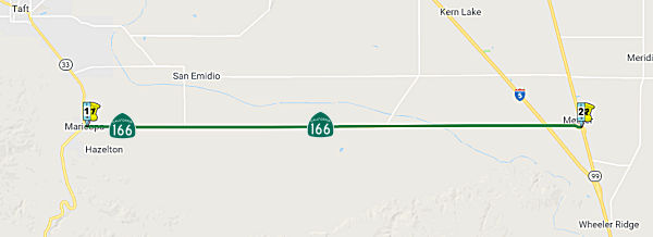 From Route 33 near Maricopa easterly to Route 99.
Post 1964 Signage HistoryThis segment remains as defined in 1963.
Pre 1964 Signage HistoryIn 1934, Route 166 was signed along the route from Jct. Route 1 at Guadalupe to Jct. US 99 S of Bakersfield via Maricopa. It was part of LRN 57, defined in 1919.
Note that this stretch was cosigned with Route 33 from 1950 until the
1964 renumbering.
(Source: Tom Fearer on California Historic Highways, 1/1/2019)
StatusIn October 2016, the CTC authorized relinqishment of right of way in the county of Kern along Route 166 at Old River Road (06-Ker-166-PM 14.86), consisting of collateral facilities. The County, by letter signed April 13, 2016, agreed to waive the 90-day notice requirement and accept title upon relinquishment by the State.
California Aqueduct Bridge (№ 50-0323) Replacement (06-KER-166 17.3/17.7)
 Replacement (06-KER-166 17.3/17.7)") In June 2021, the CTC approved Caltrans’ request
for an additional $2,450,000 in Capital Outlay Support (COS), for the
SHOPP Bridge Rehabilitation project (PPNO 06-6726; ProjID 0615000047; EA
0S050) on Route 166, in Kern County, to complete the Project Approval and
Environmental Document (PA&ED) project phase. This project is located
on Route 166 near Mettler, at the California Aqueduct Bridge (No. 50-0323)
in Kern County. The project proposes to replace the existing 3-span
bridge with a long single- span steel girder structure. The need for
the project was a result of several deficiencies with the existing
structure that included bridge deck sag and rotation, the settlement of
Piers 2 and 3, seismic deficiencies, and non-standard guardrails. This
project was initially programmed for delivery in fiscal year 2021-22. The
PA&ED phase was allocated in June 2017 for $2,400,000, and with the
available G-12 authority of $250,000, the total PA&ED phase budget was
$2,650,000. Currently, the PA&ED phase is 60 percent complete, and the
total remaining budget is $12,000. The available budget is insufficient to
complete the PA&ED phase.
In June 2021, the CTC approved Caltrans’ request
for an additional $2,450,000 in Capital Outlay Support (COS), for the
SHOPP Bridge Rehabilitation project (PPNO 06-6726; ProjID 0615000047; EA
0S050) on Route 166, in Kern County, to complete the Project Approval and
Environmental Document (PA&ED) project phase. This project is located
on Route 166 near Mettler, at the California Aqueduct Bridge (No. 50-0323)
in Kern County. The project proposes to replace the existing 3-span
bridge with a long single- span steel girder structure. The need for
the project was a result of several deficiencies with the existing
structure that included bridge deck sag and rotation, the settlement of
Piers 2 and 3, seismic deficiencies, and non-standard guardrails. This
project was initially programmed for delivery in fiscal year 2021-22. The
PA&ED phase was allocated in June 2017 for $2,400,000, and with the
available G-12 authority of $250,000, the total PA&ED phase budget was
$2,650,000. Currently, the PA&ED phase is 60 percent complete, and the
total remaining budget is $12,000. The available budget is insufficient to
complete the PA&ED phase.
(Source: June 2021 CTC Agenda, Agenda Item
2.5e.(1))
This is the first project in District 6 to rehabilitate
a structure over the California Aqueduct in decades. All proposed work
requires Department of Water Resources (DWR) approval. In October
2017, limitations set by DWR restricted work on existing piers in the
aqueduct. Thus, the retrofit strategy was changed from
rehabilitation of the existing bridge to a full bridge replacement. The
new structure will now be a single-span due to DWR policy restrictions
that will not allow bridge piers within the aqueduct. Given that the
structure is not a historic feature, the involvement of the State Historic
Preservation Officer (SHPO) was anticipated to be minimal. However,
SHPO did not agree with the finding of No Adverse Effect in the initial
Draft Environmental Document (DED) because they deemed the structure a
tributary element of the California Aqueduct, which is a historic
feature. Additionally, the size of the new structure, with an
expected height of 21 feet, was construed to be visually intrusive by SHPO
in comparison with the existing structure. SHPO’s determinations
created the need for a full Section 4(f) analysis to be completed and
amended into the environmental document. A Value Analysis (VA) study
was performed in October 2019 to explore possible cost and/or schedule
savings. The Department accepted three of the seven proposed VA
recommendations, which later resulted in the addition of a second viable
alternative (North Alignment) into the DED. Because the added alternative
required additional time, in October 2020, the Department requested and
was approved for a 30-month expenditure time extension by the Commission
to process and finalize the PA&ED phase by December 31, 2022.
(Source: June 2021 CTC Agenda, Agenda Item
2.5e.(1))
By mid-2020, further analysis determined that the North
Alignment would be in conflict with an existing high-pressure oil line.
The identified conflict will require time to secure the Right of Way (RW)
Certification, which would affect the project delivery in the proposed
programmed year in 2022-23. It is not feasible to eliminate the conflict
with the North Alignment, without extensive relocation of the utility.
Therefore, the Project Team proposed a mirror design of the North
Alignment to the south, which would retain the benefit of a similar
design, yet stay clear of the oil line. With an opportunity for cost
and time savings by avoiding the utility, the Project Team formally
adopted the South Alignment as a viable alternative and removed the North
Alignment from further consideration. This change required further
modifications to the DED, which is now anticipated to be completed in July
2021 with PA&ED to be achieved in July 2022. Thus, more resources are
required to complete the environmental phase. The project was added to the
Watch List in August 2020.
(Source: June 2021 CTC Agenda, Agenda Item
2.5e.(1))
The requested supplemental COS funds will be used to
perform the work needed to complete the PA&ED phase, prepare all
required permit data and documentations, and commence the PS&E
phase. This will also enable the Department to complete the project
design and prepare all project contract documents and plans in time to
meet the current planned delivery in 2022-23. An amendment to the capital
budget should be requested at the January 2022 Commission meeting.
(Source: June 2021 CTC Agenda, Agenda Item
2.5e.(1))
NamingThis is currently named the "Maricopa Highway".
Historically, the portion from Route 33 to Wheeler Ridge (entire segment) has been called "El Camino Viejo".
 The interchange of Route 99 and Route 166 in the County of Kern (~ KER 24.39)
is named the "CHP Officer Gerald E. Dormaier Memorial Interchange".
It was named in memory of Officer Gerald E. Dormaier, California Highway
Patrol (CHP) Badge No. 4654, who was born in June 1938, in Arvin,
California. Dormaier graduated from Bakersfield High School in 1955, went
on to Bakersfield College, and then joined the United States Air Force
shortly thereafter. Dormaier was a member of the Future Farmers of America
poultry judging team in high school and won first place over 17 other
judging teams in a San Joaquin Valley poultry judging contest held at
Fresno State College. Prior to joining the California Highway Patrol,
Dormaier worked in Kern County’s oil fields. Dormaier graduated from
the California Highway Patrol Academy in 1966, and during his 14 years
with the CHP, served in the Los Angeles, Anaheim, Tejon, Buellton,
Truckee, and Bakersfield areas. Officer Dormaier was killed in the line of
duty on December 25, 1980, when he and his partner, Officer Jerry Bean,
CHP Badge No. 6105, were attempting to set up road control for an
overturned propane truck. Officer Dormaier was standing on the side of the
road when a speeding tanker truck came barreling through the fog. The
driver attempted to stop, causing the vehicle to jackknife near the center
divider, striking Officer Dormaier and the patrol car. Officer Bean
attempted to revive his partner and administered CPR until the ambulance
arrived. Officer Dormaier was taken to Mercy Hospital, but unfortunately
he succumbed to his injuries. Named by Assembly Concurrent Resolution
(ACR) 78, Res. Chapter 155, Statutes of 2015, on September 3, 2015.
The interchange of Route 99 and Route 166 in the County of Kern (~ KER 24.39)
is named the "CHP Officer Gerald E. Dormaier Memorial Interchange".
It was named in memory of Officer Gerald E. Dormaier, California Highway
Patrol (CHP) Badge No. 4654, who was born in June 1938, in Arvin,
California. Dormaier graduated from Bakersfield High School in 1955, went
on to Bakersfield College, and then joined the United States Air Force
shortly thereafter. Dormaier was a member of the Future Farmers of America
poultry judging team in high school and won first place over 17 other
judging teams in a San Joaquin Valley poultry judging contest held at
Fresno State College. Prior to joining the California Highway Patrol,
Dormaier worked in Kern County’s oil fields. Dormaier graduated from
the California Highway Patrol Academy in 1966, and during his 14 years
with the CHP, served in the Los Angeles, Anaheim, Tejon, Buellton,
Truckee, and Bakersfield areas. Officer Dormaier was killed in the line of
duty on December 25, 1980, when he and his partner, Officer Jerry Bean,
CHP Badge No. 6105, were attempting to set up road control for an
overturned propane truck. Officer Dormaier was standing on the side of the
road when a speeding tanker truck came barreling through the fog. The
driver attempted to stop, causing the vehicle to jackknife near the center
divider, striking Officer Dormaier and the patrol car. Officer Bean
attempted to revive his partner and administered CPR until the ambulance
arrived. Officer Dormaier was taken to Mercy Hospital, but unfortunately
he succumbed to his injuries. Named by Assembly Concurrent Resolution
(ACR) 78, Res. Chapter 155, Statutes of 2015, on September 3, 2015.
(Image source: Assemblyman Rudy Salas, CHP Memorial Page)
Freeway[SHC 253.7] From Route 33 near Maricopa to Route 5. Added to the Freeway and Expressway system in 1959.
 Other WWW Links
 Statistics
Overall statistics for Route 166:
 Pre-1964 Legislative Route
In 1933, Chapter 767 added the route "Los Angeles, Indiana and 3rd Streets to the Huntington Beach-Whittier Road near Santa Fe Springs" to the highway system. In 1935, this was added to the highway code as LRN 166 with the definition:
"[LRN 172], at the intersection of Indiana and Third Streets, in Los Angeles, to [LRN 171] near Sante Fe Springs"
This route, as originally defined, ran down from 3rd St (LRN 172) and Indiana St and then across Telegraph Road (the future I-5 routing) perhaps as far as Buena Park, where it met a routing of Route 39, which was LRN 171. The routing started out as US 101 Bypass, and later became I-5. The Indiana Street portion later became short lived Route 165.
In 1941, Chapter 142 changed both endpoints, making the route from "[LRN 172] at the intersection of Downey Road Indiana and Third
Streets, in Los Angeles, to LRN 174 near Norwalk [LRN 171]
near Sante Fe Springs".
After this change, the route ran from LRN 172 (3rd Street, eventual Route 60) at the intersection of Downey Road to former Route 42 (LRN 174) near Norwalk. This included the segment of 1964-1965 Route 245 along Downey Road between Route 60 (LRN 172) and US 101, and the segment of US 101 (freeway routing) from Downey Road to LRN 174 (intersection with former Route 42).
© 1996-2020 Daniel P. Faigin.
Maintained by: Daniel P. Faigin
<webmaster@cahighways.org>.
 Route 165
 Route 167