
 California Highways:
[Click here for a key to the symbols used. Some county routes were constructed with federal funds. These routes are indicated as FAP (Federal Aid Primary), FAU (Federal Aid Urban), or FAS (Federal Aid Secondary). If no funding source is shown, no federal funds were used. Note that while some segments seem to have the same attributes, they may differ in the county-local road number assigned to the segment, or in the Caltrans Map Sheet number.]
 Routing
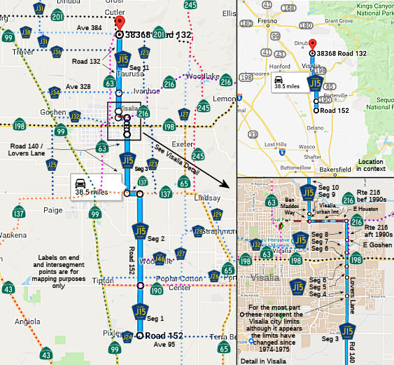 Route 152
from Tulare County Sign Route J24 to Route 190.
Route 152
from Tulare County Sign Route J24 to Route 190.
Note: This segment appears to have been added post-1975. It is not part of the 1974-1975 definition, but shows up on a 1990s-era Thomas Brothers Map
Road 152 from Route 190 to Route 137 E of Tulare (FAS, 10.90 mi).
Note: Between this segment and the next, there is a discontinity along Route 137 betweeen Road 152 and Road 140.
Lovers Lane/Road 140 from Route 137 E of Tulare to the Visalia city limits (FAS, 7.00 mi)
Lovers Lane in Visalia from the Visalia city limits to the Visalia city limits (FAS, 0.50 mi)
Lovers Lane outside Visalia from the Visalia city limits to the Visalia city limits (FAU, 0.30 mi)
Lovers Lane in Visalia from the Visalia city limits to the Visalia city limits (FAU, 0.38 mi)
Lovers Lane outside Visalia from the Visalia city limits to East Goshen Avenue (FAU, 0.42 mi).
Note: Since this segment was defined, Route 216 was routed off of E. Houston Avenue onto Lovers Lane. Route 216 was originally LRN 133, which would have utilized E Houston Ave and Northeast 3rd Avenue to reach LRN 132 at Court Street (which eventually became Route 63). Sometime in the late 1990s, Route was rerouted onto Lovers Lane to from E Houston Avenue to Route 198.
Lovers Lane in Visalia from East Goshen Avenue to Route 216 (E Houston Avenue) (FAU, 0.50 mi)
Note: Since this segment was defined, Route 216 was routed off of E. Houston Avenue onto Lovers Lane. Route 216 was originally LRN 133, which would have utilized E Houston Ave and Northeast 3rd Avenue to reach LRN 132 at Court Street (which eventually became Route 63). Sometime in the late 1990s, Route was rerouted onto Lovers Lane to from E Houston Avenue to Route 198.
Ben Maddox Way from Route 216 to the Visalia urban limits (FAU, 0.20 mi).
Note: Route 216 originally ran along E Houston Ave to NE 3rd and then down through downtown Visalia to Route 198. Sometime in the late 1990s, it was routed onto Lovers Lane. This introduced a discontinuity along E Houston Ave between Lovers Lane (new Route 216) and Ben Maddox Way. It is unknown if that segment of E Houston Ave is under county maintenance.
Ben Maddox Way (Road 132) from the Visalia urban limits to Avenue 328 (FAS, 2.80 mi)
Road 132 from Avenue 328 to Route 201 near Yettem (FAS, 6.99 mi)
 History and Signage Information
The segment of this route along Road 152 between Route 190 and Route 137 was defined in 1974. The remainder of the route was defined in 1975. Sometime post-1975, the extension S between Route 190 and County Sign Route J24 was made.
 Status
Total mileage: 29.99 mi as of 1975.
© 1996-2020 Daniel P. Faigin.
Maintained by: Daniel P. Faigin
<webmaster@cahighways.org>.
 CR J14
 CR J16