
 California Highways:
Click here for a key to the symbols used. An explanation of acronyms may be found at the bottom of the page.
 Routing
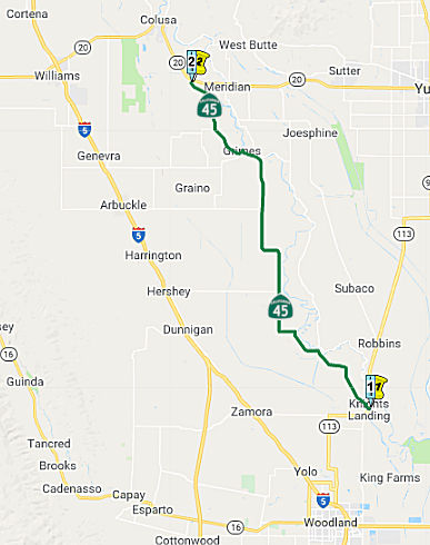 From Route 113 near Knights Landing to Route 20 near
Sycamore.
From Route 113 near Knights Landing to Route 20 near
Sycamore.
 Post 1964 Signage History
The definition of this segment is unchanged from 1963
 Pre 1964 Signage History
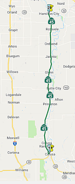 From Route 20 near Colusa to Route 32 near Hamilton City.
Post 1964 Signage HistoryThe definition of this segment is unchanged from 1963
The route between Route 45 near Sycamore and Colusa is signed as Route 45, although it is legislatively Route 20.
Route 45, along the Sacramento River between I-5 and CA 99, is the
closest thing the state has to a Deep South-style river-running highway;
the towns along its path, from Knights Landing up through Colusa and on to
Hamilton City, are most similar to towns encountered in Louisiana and
Mississippi. Most of the exterior scenes for the 1967 film "In The Heat Of
The Night" were actually filmed in and around Colusa (although the famous
chase on the bridge was filmed on the US 49 crossing of the Mississippi
River at Helena, AR). South of Colusa, Route 45 mostly stays off the
levee, zig-zagging along property lines south to its southern Knights
Landing terminus at Route 113. If you hang around Knights Landing for any
time, be prepared to discuss hunting & fishing -- it's one of the main
bird-hunting centers in the Sacramento Valley; the area between the
Sacramento and Feather rivers is full of duck, goose, and pheasant blinds.
(Source: Scott Parker at AAroads, 8/19/2016)
Pre 1964 Signage HistoryIn 1934, Route 35 was signed along the route from Jct. Route 24 (now Route 113) at Knights Landing to Jct. Route 32 Hamilton City, via Colusa. This segment was LRN 88. The portion between Route 20 and Route 162 was defined in 1959, and from Route 162 to Route 32 in 1933. It appears that the portion connecting the two segments of present day Route 162 were part of LRN 45.
 Naming
The portion of Route 45 in Colusa County is designated as part of the National Purple Heart Trail in order to honor the men and women who have been wounded or killed in combat while serving in the United States Armed Forces. Additionally, the County of Colusa Veterans Tribute Wall was erected and dedicated on Veterans Day 2014 to recognize the honorable service and sacrifices made by all veterans who have lived, or do now reside, in the County of Colusa; it is located at the junction of Route 20 and Route 45, and is accessible via all state highways within the County of Colusa. Designed by Assembly Concurrent Resolution (ACR) 191, Res. Chapter 163, Statutes of 2016, on September 1, 2016.
The portion of this segment connecting the two segments of Route 162 is part of the "Biggs-Willows Road" (~ GLE 3.052 to GLE 7.492), named by Resolution Chapter 542 in 1919.
 Named Structures
Bridge 11-0038, the "Stoney Creek Bridge" in Glenn County (GLE R020.66), is called the "Chet Walker Bridge". It was built in 1974. It was named after Chester W. Walker, who was known as "the mayor of Hamilton City". He served as chair of the North Sacramento Valley Highway Committee of the California Chamber of Commerce. He was a leader in an effort to replace the original narrow, dangerous bridge at this location.
 Freeway
[SHC 253.3] Entire portion. Added to the Freeway and Expressway system in 1959.
 Other WWW Links
 Statistics
Overall statistics for Route 45:
 Pre-1964 Legislative Route
The route that would become LRN 45 was first defined in 1919 by Chapter 54, which stated "That certain highway beginning at a point on the present state highway in Butte county about 3 mi N-ly of the town of Biggs, thence extending W-ly and crossing Cherokee Canal and Butte Creek and extending through Butte City and across the Sacramento River, thence N-ly to Glenn Post Office, thence W-ly to the town of Willows in Glenn County ... is hereby constituted a state highway..." This was codified into the 1935 state highway code as:
[LRN 3] near Biggs to [LRN 7] at Willows via Butte City and Glenn
In 1957, Chapter 1911 simplifed the definition to terminate at "[LRN 7] near Willows." This is present-day Route 162 between Route 5 and Route 99. This route is the "Biggs-Willows Road".
© 1996-2020 Daniel P. Faigin.
Maintained by: Daniel P. Faigin
<webmaster@cahighways.org>.
 Route 44
 Route 46