
 California Highways:
Click here for a key to the symbols used. An explanation of acronyms may be found at the bottom of the page.
 Routing
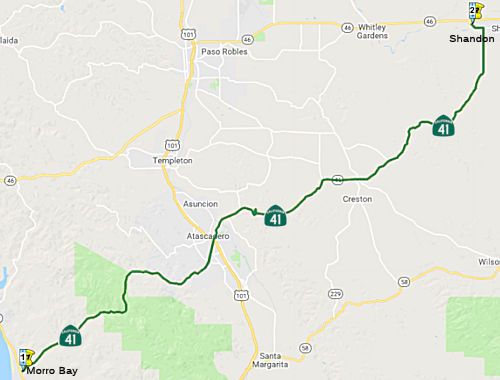 From Route 1 in Morro Bay to Route 46.
 Post 1964 Signage History
This segment remains as defined in 1963.
 Pre 1964 Signage History
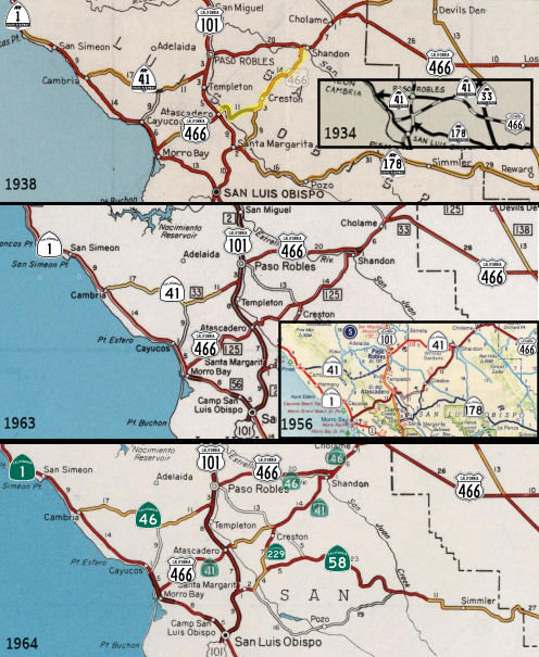 In 1934, Route 41 was signed along the route from Cambria
to Yosemite Park, via Paso Robles and Fresno. This routing ran along Santa
Rosa Creek Road (which was LRN 33) and in 1964 became Route 46.
In 1934, Route 41 was signed along the route from Cambria
to Yosemite Park, via Paso Robles and Fresno. This routing ran along Santa
Rosa Creek Road (which was LRN 33) and in 1964 became Route 46.
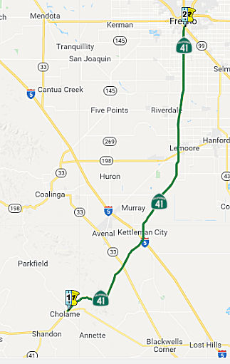
What is currently Route 41 traverses SLO County from Route 1 in Morro
Bay, crosses US 101 within the city of Atascadero, passes through a rural
portion of SLO County, and then joins Route 46 E near Shandon, a
census-designated place in SLO County. Near the unincorporated
community of Cholame, Route 41 departs from Route 46 E as a separate
highway, proceeds through the Kern County line, and continues northeast
towards the city of Fresno. On March 19, 1934, SLO County approved a
resolution authorizing the State Department of Public Works to take over
Route 41 (LRN 125 at that time) from the County under the Breed Act;
therefore, this route has never been officially adopted by the CTC.
(Source: October 2020 CTC Agenda, Agenda Item
2.3a.(3))
 Between Route 1 near Morro Bay and US 101 near Atascadero ,
post-1964 Route 41 was signed as US 466, and was LRN 125. Prior to 1959,
US 466 was defined to run along LRN 125 between Atascadero and Shandon
(although it was not signed, and the route did not correspond to
present-day Route 41). In June 1958, US 466 was rerouted to run co-signed
with US 101 to Paso Robles, where it continued along post-1964 Route 46 as
US 466 to Shandon (LRN 33). Shandon is currently where Route 46 meets
Route 41. US 466 was signed between Morro Bay and Atascadero, and from
Shandon E, as part of the initial signage of US highways in the mid-1930s
(although, as noted, the portion between Atascadero and Shandon was
unsigned). LRN 125 was defined in 1933.
Between Route 1 near Morro Bay and US 101 near Atascadero ,
post-1964 Route 41 was signed as US 466, and was LRN 125. Prior to 1959,
US 466 was defined to run along LRN 125 between Atascadero and Shandon
(although it was not signed, and the route did not correspond to
present-day Route 41). In June 1958, US 466 was rerouted to run co-signed
with US 101 to Paso Robles, where it continued along post-1964 Route 46 as
US 466 to Shandon (LRN 33). Shandon is currently where Route 46 meets
Route 41. US 466 was signed between Morro Bay and Atascadero, and from
Shandon E, as part of the initial signage of US highways in the mid-1930s
(although, as noted, the portion between Atascadero and Shandon was
unsigned). LRN 125 was defined in 1933.
Post-1964 Route 41 between Atascadero and Creston is a new routing; the portion between Creston (the end of Route 229) and Shandon was part of LRN 125 (although it does not appear to have been signed as part of US 466).
Between Paso Robles and Shandon, what is now Route 46
was signed as Route 41. This was part of the original 1934 signage of
Route 41. In Paso Robles, 1934-1964 Route 41 multiplexed US 101 on Spring
Street in downtown Paso Robles from 13th Street southward. In 1957,
construction was in progress on a new expressway grade for 1934-1964 Route 41/LRN 33 (now Route 46) east of Paso Robles towards Shandon. In 1958,
completion of the Paso Robles Bypass for US 101 shifted the alignment of
US 466/US 101/Route 41 onto a new limited access grade replacing Spring
Street.
(Sources: Tom Fearer and the crew at AARoads; Gribblenation Blog “ Former US Route 101 and California State Route 41 through Paso
Robles” (Tom Fearer), June 2021)
Between Shandon and Cholame, the route was cosigned as Route 41/US 466, and was LRN 33. This was part of the original signage of US 466. This
is now cosigned Route 41 / Route 46, and legislatively Route 46.
 Status
PPNO 1105, Route 1/Route 41 IC, operational improvements (SB1)
The 2018 STIP, approved at the CTC March 2018 meeting, appears to allocate $3.390M in construction funding in FY21-22 for PPNO 1105, Route 1/Route 41 IC, operational improvements (SB1).
The 2020 STIP, approved at the CTC March 2020 meeting,
adjusts the programmed allocation for PPNO 1105 Route 1/41 IC, operational
improvements (SB1), moving the programmed funds from FY21-22 to FY22-23.
(Source: March 2020 CTC Agenda, Item 4.7, 2020 STIP
Adopted 3/25/2020)
A portion of this route in the city of Atascadero once ran along Business Route 101. Until 2003, eastbound Route 41 crossed US 101 and then turned left on El Camino Real/Business Route 101, then turned right on West Mall Road, and continued onto Capistrano Avenue. It then crossed under the railroad, turned right on Sycamore Road, turned left onto the stub of Curbaril Avenue, continued across a bridge which no longer exists, turned left on Rocky Canyon Road, and then turned right on the short portion of Creston Eureka Road and continued east on the existing main portion of Creston Eureka Road. The westbound routing was identical, in reverse. Since then, a new routing has been constructed. This routing includes a bridge across the Salinas River, the connecting road south of that bridge to the intersection of Route 41 and El Camino Real, and the connecting road north of that bridge to the intersection of the short portion of Creston Eureka Road and its main portion. This new section is two miles long, as compared with the old, circuitous, 3.5-mile routing.
 In September 2018, there was an update on the Complete
Streets project in Atascadero. According to the report delivered by Public
Works Director Nick DeBar, the state’s transportation agency,
Caltrans, “is currently in the final design phase of the Route 41
State Highway Operation and Protection Program (SHOPP) project that will
provide for pedestrian and [Americans with Disabilities Act] ADA
improvements.” SHOPP is following a “complete streets”
doctrine with emphasis on the safety of all users. That’s especially
important, he adds, where the state-controlled roadway also serves as a
defacto mainstreet for local communities. Ringing in at over $7 million,
the councilmembers reflected that the improvements were a chance to get a
great deal of work done by the state for the cost of a relatively minor
maintenance agreement, although, it will cost streetside parking near some
businesses. The ADA compliant sidewalk improvements alone total $2.6
million. The project, slated for implementation at the end of 2019
according to Caltrans, is broadly described as being oriented around
“pedestrian safety and connectivity, including updating ADA ramps
and constructing the missing links in the sidewalks along the corridor
from El Camino Real to Portola Road.” The Route 41 SHOPP project
will allow the City to implement components of the Route 41 Complete
Streets Feasibility Study started in 2016. The preferred options included
for planning at that time included looking at Atascadero Avenue as a bike
corridor to divert that traffic from the already complex intersection and
underpass for El Camino Real and US 101 and Route 41.
In September 2018, there was an update on the Complete
Streets project in Atascadero. According to the report delivered by Public
Works Director Nick DeBar, the state’s transportation agency,
Caltrans, “is currently in the final design phase of the Route 41
State Highway Operation and Protection Program (SHOPP) project that will
provide for pedestrian and [Americans with Disabilities Act] ADA
improvements.” SHOPP is following a “complete streets”
doctrine with emphasis on the safety of all users. That’s especially
important, he adds, where the state-controlled roadway also serves as a
defacto mainstreet for local communities. Ringing in at over $7 million,
the councilmembers reflected that the improvements were a chance to get a
great deal of work done by the state for the cost of a relatively minor
maintenance agreement, although, it will cost streetside parking near some
businesses. The ADA compliant sidewalk improvements alone total $2.6
million. The project, slated for implementation at the end of 2019
according to Caltrans, is broadly described as being oriented around
“pedestrian safety and connectivity, including updating ADA ramps
and constructing the missing links in the sidewalks along the corridor
from El Camino Real to Portola Road.” The Route 41 SHOPP project
will allow the City to implement components of the Route 41 Complete
Streets Feasibility Study started in 2016. The preferred options included
for planning at that time included looking at Atascadero Avenue as a bike
corridor to divert that traffic from the already complex intersection and
underpass for El Camino Real and US 101 and Route 41.
(Source: Atascadero News, 9/28/2018)
In May 2003, the CTC considered relinquishment of the segment from PM SLO 16.7 to PM SLO 16.9 in the City of Atascadero. This is likely an original or bypass segment.
Realignment in Shandon
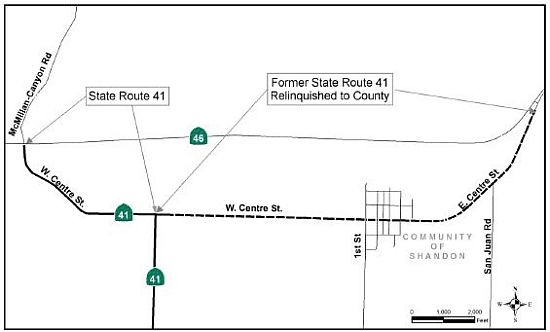 In October 2011, Caltrans and the County of San Luis Obispo have exchanged responsibilities for routes
in and near the community of Shandon. At the county's request, the state
has transferred to the county a portion of West and East Centre Street
that passes through the center of town. In exchange, the state now has
responsibility for the portion of West Centre Street to the intersection
of Route 46 and McMillan-Canyon Road (~ SLO 41.151 to SLO R42.139). This
will allow the county to implement improvements planned for the Shandon
area. In the September 2011 CTC meeting records, the following was noted:
The County of San Luis Obispo on May 17, 2011 adopted a resolution
requesting a transfer of Route 41 location from its existing easterly
alignment along West Centre Street and through the Shandon Community to an
intersection with Route 46 to the proposed new shorter westerly alignment
along West Centre Street. A Route Transfer Report was approved on July 1,
2011. The Department completed a preliminary environmental review and
determined that this project would not have a significant adverse impact
on the environment. A Categorical Exemption (CE) was signed on September
27, 2010. The background noted:
In October 2011, Caltrans and the County of San Luis Obispo have exchanged responsibilities for routes
in and near the community of Shandon. At the county's request, the state
has transferred to the county a portion of West and East Centre Street
that passes through the center of town. In exchange, the state now has
responsibility for the portion of West Centre Street to the intersection
of Route 46 and McMillan-Canyon Road (~ SLO 41.151 to SLO R42.139). This
will allow the county to implement improvements planned for the Shandon
area. In the September 2011 CTC meeting records, the following was noted:
The County of San Luis Obispo on May 17, 2011 adopted a resolution
requesting a transfer of Route 41 location from its existing easterly
alignment along West Centre Street and through the Shandon Community to an
intersection with Route 46 to the proposed new shorter westerly alignment
along West Centre Street. A Route Transfer Report was approved on July 1,
2011. The Department completed a preliminary environmental review and
determined that this project would not have a significant adverse impact
on the environment. A Categorical Exemption (CE) was signed on September
27, 2010. The background noted:
The purpose of this route adoption is to establish a new alignment for the portion of Route 41 that passes through the community of Shandon. The County of San Luis Obispo (County) requested a transfer of highway location to allow the County to better implement the Shandon Community Plan and achieve the plans’ goals to reduce interregional traffic through Shandon and to make roadway improvements that do not meet the Department’s State highway design standards. This transfer of alignment will allow existing Route 41 from Post Mile (PM) 41.2 to 43.8 to be relinquished to the County while maintaining the route concept and connectivity of Route 41 to Route 46. On February 27, 1960, the California Highway Commission adopted this portion of Route 41 as a State Highway. Route 41 traverses the counties of San Luis Obispo, Kings, Fresno, Madera and Mariposa beginning in the city of Morro Bay and terminating in Yosemite National Park. The limits of the proposed route transfer are entirely within the county of San Luis Obispo. The route is classified as a primary route, included in the Interregional Road System and has a Truck Advisory Designation. Route 41 within the project limits is a two-lane undivided conventional highway, functionally classified as rural major collector, with 10-foot lanes and a one-foot shoulder in the westbound direction and no shoulders in the eastbound direction. The current easterly alignment of Route 41, from the intersection at West Centre Street to Route 46, runs through the unincorporated community of Shandon. West Centre Street acts as the main street for Shandon and has posted speeds ranging from 55 miles per hour (mph) to 25 mph. There are no designated bike lanes or paths along the existing Route 41 roadway and the lack of paved shoulders requires bike traffic to ride with the flow of traffic on the roadway. Route 41 serves primarily through trips from the west starting at US 101, City of Atascadero, to points east including I-5, Bakersfield, Visalia and Fresno. Local traffic from farms and housing along the route also use this highway to travel to and from the community of Shandon to the city of Atascadero. The proposed new alignment (Route Adoption) begins at the intersection of Route 41 and West Centre Street (PM R41.2) and runs westerly along West Centre Street (formerly known as McMillian Canyon Road) terminating at its junction with Route 46 (PM R42.2). This route is a rural two-lane undivided conventional highway with 11-foot-wide lanes and one-foot-wide shoulders. Posted speeds range from 55 mph to 45 mph prior to horizontal curves. Both the existing and proposed alignments are comparable in geometric cross section and pavement condition. The new westerly alignment of Route 41 provides a more direct connection to Route 46 and is about a mile in length. The existing easterly alignment of Route 41, from the intersection with West Centre Street (PM 41.2) through the Shandon community to just west of the intersection of Route 41 with Route 46 (PM 43.8), would be transferred to the County and is 2.65 miles in length.
Wye - Route 41/Route 46 Interchange (05-SLO-41 PM 44.5/45.3)
 In October 2020, the CTC approved a route adoption for Route 41 as a
controlled access highway and new alignment from the Route 41/Route 46
interchange to 0.8 mile north of the SR 41/SR 46 interchange. This
adoption is a new alignment as part of the Route 46 Corridor Improvements.
The Department approved the Final Environmental Impact Report/Finding of
No Significant Impact (EIR/FONSI) on May 10, 2006 and the Project Report
(PR) on May 19, 2006. A revalidation form, as an update to the
environmental document, and a Supplemental PR and were signed on August 4,
2020 and August 28, 2020, respectively. It is recommended that the
Commission approve the route adoption resolution in accordance with the
recommendation of the Chief Engineer. The purpose of this route adoption
is to replace the existing at-grade intersection with Route 46 with a new
interchange. This project is part of the larger Route 46 Corridor
Improvements project. Left-turn movements from eastbound Route 46 to
northbound Route 41 at this intersection have resulted in a series of
collisions and backups along both routes. With the route adoption, the
construction of the new interchange will improve safety, enhance the
overall operations at the junction of these two State highways, and
improve local and interregional traffic circulation. Within the
limits of this project, existing Route 41 functions as an undivided rural
two-lane highway with a private driveway just north of the junction with
Route 46. A left-turn pocket and a median acceleration lane are present
for vehicles entering and exiting the private driveway,
respectively. Lane widths along Route 41 are 12 feet with 8-foot
shoulders. This area is referred to as the Wye section due to the severely
skewed “T” intersection (“Y”) with Route 46. The
junction consists of a stop-control configuration on Route 41 and
continuous flow on Route 46. Vehicles traveling south on Route 41 to
westbound Rout e46 have a free right-turn movement leading to a merge
point with Route 46 traffic. Vehicles traveling south on Route 41 to
eastbound Route 46 must perform a left-turn movement with no median
acceleration lane present on Route 46. The three-leg, stop-control
intersection has resulted in a series of collisions and backups over the
decades, leading to the proposal to construct an interchange between the
two routes. The new Route 46/Route 41 interchange will be constructed
northeast of the existing State route junction to avoid sensitive
environmental resources within Cholame Valley. This interchange
location and other improvements along Route 46 will require both Route 46
and Route 41 to be realigned. The entire existing alignment of Route 41
will be obliterated and environmentally restored to its natural condition
before disposal of the right-of-way as excess lands. SLO County has
reviewed and concurred with all proposed improvements. A Controlled Access
Highway Agreement (CAHA) will be executed with SLO County from the new
Route 41/Route 46 interchange to the north conform with the existing Route 41 alignment.
In October 2020, the CTC approved a route adoption for Route 41 as a
controlled access highway and new alignment from the Route 41/Route 46
interchange to 0.8 mile north of the SR 41/SR 46 interchange. This
adoption is a new alignment as part of the Route 46 Corridor Improvements.
The Department approved the Final Environmental Impact Report/Finding of
No Significant Impact (EIR/FONSI) on May 10, 2006 and the Project Report
(PR) on May 19, 2006. A revalidation form, as an update to the
environmental document, and a Supplemental PR and were signed on August 4,
2020 and August 28, 2020, respectively. It is recommended that the
Commission approve the route adoption resolution in accordance with the
recommendation of the Chief Engineer. The purpose of this route adoption
is to replace the existing at-grade intersection with Route 46 with a new
interchange. This project is part of the larger Route 46 Corridor
Improvements project. Left-turn movements from eastbound Route 46 to
northbound Route 41 at this intersection have resulted in a series of
collisions and backups along both routes. With the route adoption, the
construction of the new interchange will improve safety, enhance the
overall operations at the junction of these two State highways, and
improve local and interregional traffic circulation. Within the
limits of this project, existing Route 41 functions as an undivided rural
two-lane highway with a private driveway just north of the junction with
Route 46. A left-turn pocket and a median acceleration lane are present
for vehicles entering and exiting the private driveway,
respectively. Lane widths along Route 41 are 12 feet with 8-foot
shoulders. This area is referred to as the Wye section due to the severely
skewed “T” intersection (“Y”) with Route 46. The
junction consists of a stop-control configuration on Route 41 and
continuous flow on Route 46. Vehicles traveling south on Route 41 to
westbound Rout e46 have a free right-turn movement leading to a merge
point with Route 46 traffic. Vehicles traveling south on Route 41 to
eastbound Route 46 must perform a left-turn movement with no median
acceleration lane present on Route 46. The three-leg, stop-control
intersection has resulted in a series of collisions and backups over the
decades, leading to the proposal to construct an interchange between the
two routes. The new Route 46/Route 41 interchange will be constructed
northeast of the existing State route junction to avoid sensitive
environmental resources within Cholame Valley. This interchange
location and other improvements along Route 46 will require both Route 46
and Route 41 to be realigned. The entire existing alignment of Route 41
will be obliterated and environmentally restored to its natural condition
before disposal of the right-of-way as excess lands. SLO County has
reviewed and concurred with all proposed improvements. A Controlled Access
Highway Agreement (CAHA) will be executed with SLO County from the new
Route 41/Route 46 interchange to the north conform with the existing Route 41 alignment.
(Source: October 2020 CTC Agenda, Agenda Item
2.3a.(3))
In April 2022, it was reported that Caltrans the
project to improve the Route 46/Route 41 interchange is expected to begin
in 2024.
(Source: KSBY, 4/13/2022)
In December 2022, the CTC approved for future
consideration of funding the following project for which a FEIR and an
Addendum have been completed: Route 46 and Route 41 in San Luis Obispo
County (05-SLO-46, PM 54.0/57.8; 05-SLO-41, PM 44.5/45.3). Realign and
widen from two lanes to four lanes, on Route 46 and Route 41, in San Luis
Obispo County. (PPNO 05-0226K). This project is located on Route 46, at
post mile 54.0 and ending at post mile 57.8 and Route 41, at post mile
44.5 and 45.3, in San Luis Obispo County. The Department proposes a Route Adoption at the Wye Section of the Route 46 Corridor Improvement Project.
The purpose of this project is to minimize fatal accidents, improve
safety, and reduce congestion on Route 46 between Paso Robles and Cholame,
a critical east-west corridor connecting the Central Coast and Central
Valley. This project is currently programmed in the 2022 STIP for
$146,200,000 which includes Construction (capital and support) and Right
of Way (capital and support). Construction is estimated to begin in 2023.
The scope, as described for the preferred alternative, is consistent with
the project scope programmed by the Commission in the 2022 STIP. A FEIR
was prepared because of potential biological resource impacts. A copy of
the FEIR has been provided to Commission staff. The Commission approved
the project for future consideration of funding on October 22, 2020, under
Resolution E-20-100. Biological impacts would result from the construction
of the preferred alternative. This would require the acquisition and
disturbance of land throughout the entire length of the project. The
Department subsequently completed an Addendum to the FEIR pursuant to the
California Environmental Quality Act. The Department has approved this
project for construction. This approval and the Addendum satisfy the
environmental requirements for this stage of the planning process.
(Source: December 2022 CTC Agenda, Agenda Item
2.2c.(8))
In December 2022, the CTC approved a request for
$171,420,000, consisting of $155,870,000 (59.4% increase) allocation in
Construction Capital and $15,550,000 (16.0% increase) allocation in
Construction Support, for the STIP Roadway Widening project on Route 46,
in San Luis Obispo County. (05-SLO-46, PM 54.0/57.8; 05-SLO-41, PM
44.5/45.3) (PPNO 05-0226K, ProjID 0514000028, EA 3307C) . In March 2014,
the project was programmed in the STIP with $62,000,000 in Construction
Capital and $9,500,000 in Construction Support future need in Fiscal Year
2018-19. In March 2018, during development of the 2018 STIP, the
project was reprogrammed for $97,800,000 in Construction Capital,
$95,300,000 from the IIP and $2,500,000 from the RIP, and $13,400,000 in
Construction Support from the IIP. In June 2022, the project
received a 20-month allocation time extension for the Construction Capital
and Construction Support to complete the Construction Management/General
Contractor (CMGC) process after Ready to List was achieved. In October
2022, the Agreed to Price with the CMGC reflected the need of $155,870,000
in Construction Capital (59.4 percent over the programmed amount) and
$15,550,000 in Construction Support (16.0 percent over the programmed
amount). The Department plans to award the project in January 2023,
and begin construction in March 2023. Construction is planned for
three construction seasons with a duration of 500 working days. The
construction capital cost estimate is greater than the programmed amount
following the project’s refinement of the final design at Plans,
Specifications, and Estimate. During Fiscal Year 2019-20, the Department
elected to utilize the CMGC delivery method. The preconstruction
services contract was awarded to a contractor during the middle of
2020-21. The CMGC process identified several innovations as the Department
finalized the construction documents. Included in these innovations
were switching the pavement from continuously reinforced concrete to
asphalt concrete, utilizing existing Route 46 when allowable instead of
reconstructing near the eastern limits of the project, and optimizing
embankment settlement strategies. In total, the Department utilized
18 innovations developed by the Department’s Division of Design,
CMGC, and Independent Cost Estimator (ICE) consultant to reduce the
project costs by 28 percent (nearly $40,000,000). The Department
received a 20-month allocation time extension in June 2022, to allow for
the CMGC process to incorporate these innovations and allow flexibility to
reach an Agreed to Price with the contractor. As part of the CMGC
process, the Department also procured an ICE consultant, who works
directly for the Department, to ensure the prices from the CMGC contractor
are consistent with industry and the innovations proposed are feasible.
The three estimate results indicate the programmed amount for Construction
Capital costs were underestimated due to the escalation costs the market
has seen recently. The current cost estimate differs significantly from
the estimate used to validate the current programing for the
project. A major reason for this difference is trucking.
Material and equipment delivered to the work site or transported on site
are affected by the current higher trucking prices, so the impact is
widespread. A comparison of trucking cost increases since January
2021, which is when the programming could last be updated per STIP
guidelines, shows a 45.5 percent increase in hourly trucking rates.
Trucking represents about 10.9 percent of the total price on this project,
which is an increase of $5,240,000.
(Source: December 2022 CTC Agenda, Agenda Item
2.5d.(2))
In December 2022, Caltrans announced that the
California Transportation Commission had approved funding for the $171
million project reconfiguration of Route 46/Route 41 into a four-lane
expressway., which will break ground in March 2023 and take three years to
complete. The long-awaited upgrade will replace the dangerous Cholame
“Y” interchange with a flyover connection that routes
Fresno-bound traffic from Route 46 East to northbound Route 41. The
stretch of renovated road includes the location of Dean’s Sept. 30,
1955, fatal head-on collision, where his Porsche Spyder collided with
then-Cal Poly student Donald Turnupseed’s sedan turning left across
the roadway to Route 41. Once this project is complete, only one final
3.5-mile segment of Route 46 East along the Antelope Grade in San Luis
Obispo County to roughly half a mile within Kern County will remain to be
widened.
(Source: San Luis Obispo Tribune, 12/10/2022)
In April 2023, it was reported that Caltrans has broken
ground on the project to construct a new interchange at the Route 46/Route 41 "Y" in northern San Luis Obispo County. The project will also widen
nearly four miles of Route 46 to four lanes from west of Davis Road to
west of Antelope Road. This follows a project that has widened Route 46 in
multiple phases starting in Paso Robles. Eventually, Route 46 will be a
four-lane divided expressway from US 101 in Paso Robles to I-5 in Kern
County. The $148 million project is expected to take three years to
complete.
(Source: KSBY, 4/26/2023)
In January 2024, it was reported that construction on
this project has progressed to the point where a traffic switch onto a
segment of the newly constructed lanes is required. While construction
proceeds on the new eastbound lanes of the highway, traffic will be routed
onto the new alignment of what will eventually become the westbound lanes
of Route 46 East; this segment will include two-way travel from just east
of the Shandon Rest Area to just west of the Route 46/Route 41
“Wye” Interchange. Businesses will remain open during this
traffic shift. Travelers will maintain access to Bitterwater Road and the
Jack Ranch Café via a temporary driveway constructed just east of
Bitterwater Road. This temporary traffic shift is anticipated to be
in place until early summer 2024.
(Source: Paso Robles Press, 1/15/2024)
 Naming
 This segment is officially designated the "E.G. Lewis Highway" (~ SLO 0.000 to SLO
R42.139). Edward Gardner Lewis was born in Connecticut in 1869. He
purchased the Atascadero Rancho and moved west in 1912. In this role, he
became solely responsible for the planning, design, and construction of
much of the 40 square mile Atascadero Colony, now known as the City of
Atascadero. Mr. Lewis built a printing plant, an all-under-one roof
shopping center, schools, a hospital providing full medical coverage for
all his employees, paved the state highway, El Camino Real, on its 10 mile
stretch through the City of Atascadero, and planted thousands of acres of
orchards. He also purchased a three mile strip of land along the Pacific
Coast 17 miles west of Atascadero and saw the need for a road from
Atascadero to the beach so that the residents of Atascadero would have a
direct route to the coast for recreation. This road, Morro Road, is now
Route 41. Named by Assembly Concurrent Resolution No. 76, Chapter 47, in
1994.
This segment is officially designated the "E.G. Lewis Highway" (~ SLO 0.000 to SLO
R42.139). Edward Gardner Lewis was born in Connecticut in 1869. He
purchased the Atascadero Rancho and moved west in 1912. In this role, he
became solely responsible for the planning, design, and construction of
much of the 40 square mile Atascadero Colony, now known as the City of
Atascadero. Mr. Lewis built a printing plant, an all-under-one roof
shopping center, schools, a hospital providing full medical coverage for
all his employees, paved the state highway, El Camino Real, on its 10 mile
stretch through the City of Atascadero, and planted thousands of acres of
orchards. He also purchased a three mile strip of land along the Pacific
Coast 17 miles west of Atascadero and saw the need for a road from
Atascadero to the beach so that the residents of Atascadero would have a
direct route to the coast for recreation. This road, Morro Road, is now
Route 41. Named by Assembly Concurrent Resolution No. 76, Chapter 47, in
1994.
(Image source: Wikipedia)
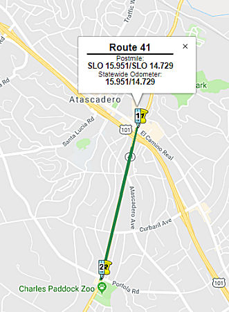
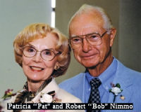 The portion of Route 41 between Creston Road and El
Camino Real (map) in San Luis Obispo County (~ SLO 15.953 to SLO 28.1) is named the "Robert and Pat
Nimmo Memorial Highway". It was named in honor of Robert and Pat
Nimmo. Robert Nimmo was born in Balboa, California in 1922 to a pioneer
ranching family. He married Patricia Anne Stone in 1950, and together they
had three children, Mary, Augusta, and Kathleen. Robert Nimmo enrolled at
the California Polytechnic State University, San Luis Obispo in 1940 and
later joined the Cal Poly Rodeo Team. He served from 1943 through 1946 as
a pilot in the United States Army Air Corps, and from 1950 through 1952 as
Company Commander, 161st Ordnance Company. His crew was later assigned to
the 448th Bombardment Group, 8th United States Air Force, flying missions
over France and Germany during the landing at Normandy on June 6, 1944. He
also worked with the California State Military Department in various
military assignments from 1955 through 1970. He became a member the
California National Guard at Camp San Luis Obispo, later earned the
position of commanding officer of San Luis Obispo's 161 Ordnance Depot
Company, and later became installation commander at Camp San Luis. He
retired with the rank of colonel and in 1964 graduated from the United
States Army Command and General Staff College. He was appointed in 1970 by
Governor Ronald Reagan to serve as United States property and fiscal
officer for the State of California from 1970 through 1972. He served as a
California State Assembly Member from 1972 through 1976, representing the
counties of Monterey, San Luis Obispo, and Santa Barbara, and as a
California State Senator from 1976 through 1980, representing the counties
of Monterey, San Luis Obispo, Santa Barbara, and Santa Cruz. Legislation
authored by Robert Nimmo included the development of facilities at
California Polytechnic State University, San Luis Obispo, improvements to
schools in the Atascadero Unified School District, conservation efforts
devoted to Morro Bay State Park, and the protection of Moonstone Beach. He
served on the Assembly Agriculture, Energy and Diminishing Materials,
Resources and Land Use, Elections and Reapportionment, Employment and
Public Employees, Natural Resources and Conservation, Water, and
Retirement Committees, as well as the Senate Rules Finance, Agriculture,
Local Government, Water Resources, and Revenue and Taxation Committees. He
was appointed by President Ronald Reagan as the Adminstrator of Veteran's
Affairs; and served on the Atascadero city council from 1990 to 1994 and
as Mayor of Atascadero from 1992 through 1994. Robert Nimmo died on
November 7, 2005. As for Patricia Nimmo, she established Nimmo Realty
Corp. in Atascadero and worked as a real estate broker for more than 40
years. Patricia Nimmo was a wonderfully energetic participant in the
Republican Women's Federation, the Atascadero Chamber of Commerce, and St.
William's Church in Atascadero. Patricia Nimmo was the victim of a tragic
car accident while walking with her husband near Route 41. Named by
Assembly Concurrent Resolution (ACR) 122, Resolution Chapter 94, on
7/23/2008.
The portion of Route 41 between Creston Road and El
Camino Real (map) in San Luis Obispo County (~ SLO 15.953 to SLO 28.1) is named the "Robert and Pat
Nimmo Memorial Highway". It was named in honor of Robert and Pat
Nimmo. Robert Nimmo was born in Balboa, California in 1922 to a pioneer
ranching family. He married Patricia Anne Stone in 1950, and together they
had three children, Mary, Augusta, and Kathleen. Robert Nimmo enrolled at
the California Polytechnic State University, San Luis Obispo in 1940 and
later joined the Cal Poly Rodeo Team. He served from 1943 through 1946 as
a pilot in the United States Army Air Corps, and from 1950 through 1952 as
Company Commander, 161st Ordnance Company. His crew was later assigned to
the 448th Bombardment Group, 8th United States Air Force, flying missions
over France and Germany during the landing at Normandy on June 6, 1944. He
also worked with the California State Military Department in various
military assignments from 1955 through 1970. He became a member the
California National Guard at Camp San Luis Obispo, later earned the
position of commanding officer of San Luis Obispo's 161 Ordnance Depot
Company, and later became installation commander at Camp San Luis. He
retired with the rank of colonel and in 1964 graduated from the United
States Army Command and General Staff College. He was appointed in 1970 by
Governor Ronald Reagan to serve as United States property and fiscal
officer for the State of California from 1970 through 1972. He served as a
California State Assembly Member from 1972 through 1976, representing the
counties of Monterey, San Luis Obispo, and Santa Barbara, and as a
California State Senator from 1976 through 1980, representing the counties
of Monterey, San Luis Obispo, Santa Barbara, and Santa Cruz. Legislation
authored by Robert Nimmo included the development of facilities at
California Polytechnic State University, San Luis Obispo, improvements to
schools in the Atascadero Unified School District, conservation efforts
devoted to Morro Bay State Park, and the protection of Moonstone Beach. He
served on the Assembly Agriculture, Energy and Diminishing Materials,
Resources and Land Use, Elections and Reapportionment, Employment and
Public Employees, Natural Resources and Conservation, Water, and
Retirement Committees, as well as the Senate Rules Finance, Agriculture,
Local Government, Water Resources, and Revenue and Taxation Committees. He
was appointed by President Ronald Reagan as the Adminstrator of Veteran's
Affairs; and served on the Atascadero city council from 1990 to 1994 and
as Mayor of Atascadero from 1992 through 1994. Robert Nimmo died on
November 7, 2005. As for Patricia Nimmo, she established Nimmo Realty
Corp. in Atascadero and worked as a real estate broker for more than 40
years. Patricia Nimmo was a wonderfully energetic participant in the
Republican Women's Federation, the Atascadero Chamber of Commerce, and St.
William's Church in Atascadero. Patricia Nimmo was the victim of a tragic
car accident while walking with her husband near Route 41. Named by
Assembly Concurrent Resolution (ACR) 122, Resolution Chapter 94, on
7/23/2008.
(Image Source: Atascadero News)
Historically, this segment is supposedly part of the "Sierra to the Sea" Highway, although other records indicate that name belongs to Route 198.
 Named Structures
 The Alluvial Avenue undercrossing, located at FRE R30.949 in the County of Fresno, is named
the “Ambassador Phillip V. Sanchez Memorial Bridge”.
It was named in memory of Phillip V. Sanchez, who was born in July 1929 in
his family’s residence in Pinedale, a small community less than a
mile’s distance from what is now the interchange of Route 41 and
Herndon Avenue in the County of Fresno. Except for Presidential
assignments to foreign countries, and military service deployments by the
United States Army, Ambassador Sanchez lived on Alluvial Avenue in
Pinedale, and embodied the promise of the American dream in his journey
from poverty to prosperity as a leader in government, business, education,
and publishing. He became the highest ranking Hispanic official in the
administrations of Presidents Richard Nixon, Gerald Ford, and Ronald
Reagan, as a Unites States Ambassador and Director of the United States
Office of Economic Opportunity. While serving as the Director of the
United States Office of Economic Opportunity, with a budget of
$400,000,000 and a nationwide staff of 262,000 employees, Ambassador
Sanchez was frequently lauded by members of Congress, from both sides of
the aisle, for his leadership and accountability to taxpayers. Sanchez,
who was fatherless since he was six years old, graduated magna cum laude
from Clovis High School and Coalinga City College, and summa cum laude
from California State University, Fresno. He was President and Founder of
the first Sigma Chi Fraternity Chapter at California State University,
Fresno, and was a trustee and former president of the National Hispanic
University. While a student at California State University, Fresno, he
enlisted in the California Army National Guard as Private (E-1), the
lowest rank, and climbed through the ranks to become Master Sergeant, the
highest enlisted grade. He was promoted to Warrant Officer 1 (WO1), the
lowest grade, and climbed through the warrant grades to Warrant Officer 4
(WO4), the then highest grade. He was accepted by the United States Army
to attend Officer Candidate School at Fort Benning, Georgia, and graduated
from Officer Candidate School with the highest levels of academic and
leadership achievement, and was commissioned as a Second Lieutenant. He
climbed through the commissioned officer ranks to Colonel, the highest
field grade in the United States Army. A 1984 Pentagon review of military
personnel records since World War I revealed that, among the millions who
served, Ambassador Sanchez had advanced through all enlisted grades, all
warrant officer grades, and all infantry commissioned grades to the
highest field rank of colonel. He retired after more than 40 years of
military service in the United States Army, the United States Army
Reserve, and the California Army National Guard. At the age of 33, as
Chief Administrative Officer of the County of Fresno, Ambassador Sanchez
was the youngest chief administrative officer in the history of all
California counties. He became a member of the Board of Trustees for the
Clovis Unified School District, and served with distinction before being
appointed by Governor Ronald Reagan to serve on the Board of Governors of
the California Community Colleges, and, subsequently, was appointed to the
Trustees of the California State University. Ambassador Sanchez has a
charter school named after him in the City of Fresno, as well as three
orphanages located in Mexico that he founded and funded. Sanchez died in
October 2017. Named by Assembly Resolution ACR 130, Res. Chapter 126, 08/19/22.
The Alluvial Avenue undercrossing, located at FRE R30.949 in the County of Fresno, is named
the “Ambassador Phillip V. Sanchez Memorial Bridge”.
It was named in memory of Phillip V. Sanchez, who was born in July 1929 in
his family’s residence in Pinedale, a small community less than a
mile’s distance from what is now the interchange of Route 41 and
Herndon Avenue in the County of Fresno. Except for Presidential
assignments to foreign countries, and military service deployments by the
United States Army, Ambassador Sanchez lived on Alluvial Avenue in
Pinedale, and embodied the promise of the American dream in his journey
from poverty to prosperity as a leader in government, business, education,
and publishing. He became the highest ranking Hispanic official in the
administrations of Presidents Richard Nixon, Gerald Ford, and Ronald
Reagan, as a Unites States Ambassador and Director of the United States
Office of Economic Opportunity. While serving as the Director of the
United States Office of Economic Opportunity, with a budget of
$400,000,000 and a nationwide staff of 262,000 employees, Ambassador
Sanchez was frequently lauded by members of Congress, from both sides of
the aisle, for his leadership and accountability to taxpayers. Sanchez,
who was fatherless since he was six years old, graduated magna cum laude
from Clovis High School and Coalinga City College, and summa cum laude
from California State University, Fresno. He was President and Founder of
the first Sigma Chi Fraternity Chapter at California State University,
Fresno, and was a trustee and former president of the National Hispanic
University. While a student at California State University, Fresno, he
enlisted in the California Army National Guard as Private (E-1), the
lowest rank, and climbed through the ranks to become Master Sergeant, the
highest enlisted grade. He was promoted to Warrant Officer 1 (WO1), the
lowest grade, and climbed through the warrant grades to Warrant Officer 4
(WO4), the then highest grade. He was accepted by the United States Army
to attend Officer Candidate School at Fort Benning, Georgia, and graduated
from Officer Candidate School with the highest levels of academic and
leadership achievement, and was commissioned as a Second Lieutenant. He
climbed through the commissioned officer ranks to Colonel, the highest
field grade in the United States Army. A 1984 Pentagon review of military
personnel records since World War I revealed that, among the millions who
served, Ambassador Sanchez had advanced through all enlisted grades, all
warrant officer grades, and all infantry commissioned grades to the
highest field rank of colonel. He retired after more than 40 years of
military service in the United States Army, the United States Army
Reserve, and the California Army National Guard. At the age of 33, as
Chief Administrative Officer of the County of Fresno, Ambassador Sanchez
was the youngest chief administrative officer in the history of all
California counties. He became a member of the Board of Trustees for the
Clovis Unified School District, and served with distinction before being
appointed by Governor Ronald Reagan to serve on the Board of Governors of
the California Community Colleges, and, subsequently, was appointed to the
Trustees of the California State University. Ambassador Sanchez has a
charter school named after him in the City of Fresno, as well as three
orphanages located in Mexico that he founded and funded. Sanchez died in
October 2017. Named by Assembly Resolution ACR 130, Res. Chapter 126, 08/19/22.
(Image source: Fresno State News)
 Other WWW Links
 Scenic Route
 Freeway
[SHC 253.3] From Morro Bay to Route 101 near Atascadero. Added to the Freeway and Expressway system in 1959.
 From Route 46 to Route 99 in Fresno.
Post 1964 Signage HistoryIn 1963, this segment was defined as "Route 46 to Route 99 near Fresno." In 1992, Chapter 1243 changed this to "in Fresno".
Pre 1964 Signage HistoryIn 1934, Route 41 was signed along the route from Cambria to Yosemite Park, via Paso Robles and Fresno. Between the US 466 (now Route 46) divergence near Cholame to US 99 (LRN 4), the route was part of LRN 125, defined in 1933.
Route 41 originally took a swing southeast of Kettleman City on 25th
Avenue and had a couple doglegs south to reach the Kettleman Plains. This
routing seemingly lasted until the renumbering in 1964. The Kettlemans are
essentially packed up loam soil, common in the West Valley; seismic
activity was the likely culprit in their formation; there's little bedrock
to get in the way of activities such as scraping chunks off the top to
place highway alignments or even drilling down to the oil underneath the
upper layers. Originally it would have been cheaper just to follow the
topology as it existed; when interregional traffic on Route 41 and other
area routes started to increase, it became necessary to do whatever cut
& fill was necessary to effect an efficient and faster routing. The
coming of I-5 in the mid-late 60's likely was prominent among those
factors that brought about the various realignments; the Division of
Highways figured that the new freeway would bring additional traffic to
the intersecting routes (particularly Route 41), so upgrades were in
order. The original alignment can be seen here on this 1935 California Division of Highways Map of Kings County. The following is a summary of the changes in the route from a post by Max Rockatansky on
AARoads:
(Source: Tom Fearer (Max Rockatansky). and Scott Parker on AAroads, April 2017; as well as this thread)
The original alignment is kind of odd with various 90 degree turns and a weird loop through the Kettelman Hills. Started out on Elm Avenue at Camden Fresno County which carried Route 41 south of the city of Fresno. Camden is one of the San Joaquin Valley towns that really isn't an inhabited place anymore. Supposedly Camden had a post office for a couple years in the early 20th century but today there is nothing but a gas station and a couple abandoned houses. Route 41 ran south on Elm to Excelsior Avenue along the Kings County Line before making right turn to run west. The original alignment on Excelsior runs under the modern Route 41 expressway. Route 41 cut of Excelsior southward again on 19th Avenue at a place called Hub. Supposedly Hub is named after some bar that carries an identical name and for reason it is considered a "place" even back on the 1935 Kings County Map. There was a railroad through Hub in the 1930s which might lend explanation to why it exists as it could have been a railroad siding. About a half mile south of Hub 19th Ave ends at the modern Route 41 expressway, it appears the northbound lanes were the original alignment south to Lemoore. It appears that Hub was bypassed by 1965 as the change in alignment can be seen from 1964 to 1965 on the state highway maps. Modern Route 41 continues as expressway on the alignment of what was 19th Avenue until Hanford/Armona Road (Old Route 198) where it swings west to bypass Lemoore. 19�th Avenue still exists within Lemoore and has a really obvious cut-off stub. Lemoore was likely bypassed by the Route 41 expressway in 1967 as a stub bow of the highway can be seen on the state highway map that wasn't present in 1966. South of Lemoore the modern expressway ends and Route 41 merges back in with the alignment of 19th Avenue. Both Route 41 and Route 198 would have taken an western right hand turn at Jackson Avenue. Route 41 dropped off of Route 198 at 20th Avenue where it took a left turn to head south again. Oddly this 90 degree turn wasn't bypassed until the early 1970s and the change can be seen from the 1970 State Highway Map to 1975. Continuing south on Route 41 the original alignment used to run directly through Stratford and continued straight on 20th Avenue. Original Route 41 then took a right to turn west on Laurel Avenue. Route 41 continued west into downtown Stratford where the southbound/northbound lanes bisected the town square on one-way Main Street before converging again. At the town limits of Stratford Main Street becomes Laurel Avenue and Route 41 continued west. Stratford was bypassed by the modern Route 41 alignment in what appears to be 1957 as a difference can be seen on the state highway map from 1956. Originally Route 41 continued west past the modern highway alignment over the Kings River. Route 41 then took another sudden southward turn left on 22nd Avenue. Route 41 originally ran south to what is still the current southwesterly alignment to Kettleman City. The bypass for Laurel Avenue and 22nd Avenue was opened between 1942 and 1944. Route 41 from 22nd Avenue through Kettleman City is essentially the same as it always been. Kettleman City was settled in 1929 near the site of a ferry after Tulare Lake had largely dried out. The big draw was the oil fields up in the Kettelman Hills. Despite the name Kettleman City isn't an incorporated place and is an infamous speed trap for Route 41. Originally Route 41 continued south on 25th Avenue here instead of directly straight towards I-5. There isn't much to see the way of the old alignment of Route 41 as the roadway on 25th was apparently upgraded during the construction of I-5. Later construction of the California Aqueduct led to the original alignment getting cut-off in the Kettelman Hills. Route 41 would have followed 25th Avenue along side the California Aqueduct. Beyond that looking east in the low lying farm land was all once Tulare Lake which was once the largest fresh water lake west of the Great Lakes. Apparently Tulare Lake was measured at 570 square miles in 1849 to a high or 690 square miles in 1879. Tulare Lake was fed by the Kings, Kaweah, Tule, and Kern River basins which were largely engineered for irrigation or flood control. A portion of modern Route 41 actually was within in the high crest of the lake. The last major flood of Tulare Lake was back in 1938 and it largely has remained farm land ever since. The last state highway map to show Tulare Lake was in 1922 where it can be seen directly south of Stratford. Modern Route 41 basically is a direct southwest shot through the Kettelman Hills whereas the original alignment crossed the location of the California Aquaduct and curved through the terrain. Most of the original alignment is inaccessible save for a small strip at the gate of the Aquaduct. Apparently the original alignment of Route 41 still appears as "Old State Highway" on modern maps and can be easily seen from Google. The original alignment appears to have always been dirt/gravel and was replaced in 1960. Even the new alignment Route 41 uses today through the Kettleman Hills doesn't appear to have been paved along with the Kettleman Plain until 1962. Directly south of the Kettelman Hills, Route 41 rejoined the more or less current alignment approaching Route 33. Looking north that the original alignment of Route 41 may be seen following the power lines to the Waste Management dump site. South from this point to Route 46 the alignment of Route 41 is largely the same as it always has been sans for one difference. For whatever reason in this valley the original alignment was replaced with a new road directly to east of the old one. The original Route 41 has been ground down by a grading machine in the somewhat recent past and has evidence of stray strips of asphalt. the old alignment actually crosses a gas station parking lot and even Route 33 before it merges back in with the modern highway.
(Source: AARoads Discussion, April 2017)
North of Leemore, LRN 125 when first plotted ran north from Lemoore in
Kings County north via 19th 1/2 Avenue to Excelsior Avenue at the Fresno
County Line. LRN 125 northbound jogged briefly easterly on Excelsior
Avenue to Elm Avenue. LRN 125 would follow Elm Avenue northward to
Elkhorn Avenue. LRN 125 followed another brief eastward jog to a
second segment of Elm Avenue which it followed north to the City of
Fresno. Following the construction of Naval Air Station Lemoore in 1961,
both Route 198 and Route 41 were modernized. By 1964, a two lane
expressway segment of Route 41 was built via a diagonal line from
Excelsior Avenue north to Elkhorn Avenue. This diagonal two lane
expressway grade of Route 41 bisected the former alignment of Elm Avenue
and reconnected back to it at Elkhorn Avenue. The new diagonal two
lane expressway served as the beginning of a four lane expressway that
would eventually bypass Lemoore and connect to the Route 198 freeway by
1998. In 2004, Route 41 south from the Fresno City Limit to Elkhorn Avenue
was completed to four lane expressway standards. The Excelsior
Avenue-Elkhorn Avenue segment of Route 41 remained a two-lane expressway
connecting to the second four lane segment approaching Lemoore. In 2021,
there were a series of safety improvements to this segment in lieu of a
full widening and conversion of the segment (see
the STATUS section below for details, "Death Alley: Excelsior Ave (~ KIN
R48.231) to Elkhorn Ave (~FRE M6.121)" and "Excelsior Expressway
(06-Fre-041 0.0/7.1)")
(Source: Gribblenation Blog (Tom Fearer), "California State Route 41; The 2 Lane Death Trap Corridor", August 2021)
In Fresno in 1938, Route 41 entered from the South along Elm Avenue and C
Street to Fresno St., along Fresno St. to Broadway, and then N to
Stanislaus St, heading E to Blackstone Ave and then out of town to
Yosemite.
(Source: 1938 Map posted on FB by Joel Windmiller)
StatusThe 2020 SHOPP, approved in May 2020, included the following NEW Long
Lead Roadway Preservation item of interest: 06-Kings-41 PM
0.0/15.5 PPNO 6988 Proj ID 0619000004 EA 0Y170. Route 41 near Kettleman
City, from Kern County line to 0.5 mile south of Route 5. Rehabilitate
pavement, construct rumble strips, and rehabilitate sign structures and
drainage systems. Note: Complexity and duration of
environmental permitting due to presence of biological and cultural
resources. Programmed in FY24-25, with construction scheduled to start in
January 2025. Total project cost is $24,490K, with $18,530K being capital
(const and right of way) and $5,960K being support (engineering,
environmental, etc.). Only the allocation of $1,400K for the PA&ED
phase is allocated.
(Source: 2020 Approved SHOPP a/o May 2020)
In March 2018, the CTC approved $3,231,000 in SHOPP funding for Kings
06-Kin-41 8.1/R48.3 On Route 41 In and near Kettleman City and Lemoore,
from Route 33 to the Fresno County line at various locations. Outcome/Output:
Improve safety by constructing shoulder and centerline rumble strips to
reduce the number and severity of collisions.
(Source: CTC Agenda, March 2018 Agenda Item 2.5f)
Bernard Drive Roundabout - 06-Kin-41 16.6/16.9
 In December 2019, the CTC had on its agenda the following SHOPP amendment:
06-Kin-41 16.6/16.9 PPNO 7031. Proj ID 0619000078. EA 0X950. Route 41 Near
Kettleman City, from 0.1 mile south to 0.2 mile north of Bernard Drive.
Construct roundabout. (Additional $1,700,000 from local contribution).
Total Cost: $14,400K. Begin Const: 3/29/2024.
In December 2019, the CTC had on its agenda the following SHOPP amendment:
06-Kin-41 16.6/16.9 PPNO 7031. Proj ID 0619000078. EA 0X950. Route 41 Near
Kettleman City, from 0.1 mile south to 0.2 mile north of Bernard Drive.
Construct roundabout. (Additional $1,700,000 from local contribution).
Total Cost: $14,400K. Begin Const: 3/29/2024.
(Source: December 2019 CTC Agenda, Agenda Item
2.1a.(1a) Item 22)
In December 2019, the CTC authorized the following
pre-construction allocation: 06-Kin-41 16.6/16.9. PPNO 7031 Proj ID
0619000078 EA 0X950. Route 41 Near Kettleman City, from 0.1 mile south to
0.2 mile north of Bernard Drive. Construct roundabout. (Additional
$1,700,000 from local contribution). (Concurrent amendment under SHOPP
Amendment 18H-013; December 2019.) PA&ED $1,700,000
(Source: December 2019 CTC Agenda, Agenda Item
2.5b.(2a) #15)
The 2020 SHOPP, approved in May 2020, included the
following Collision Reduction item of interest (carried over from the 2018
SHOPP): 06-Kings-41 PM 16.6/16.9 PPNO 7031 Proj ID 0619000078 EA 0X950.
Route 41 near Kettleman City, from 0.1 mile south to 0.2 mile north of
Bernard Drive. Construct roundabout. (Additional $1,700,000 from local
contribution). Programmed in FY23-24, with construction scheduled to start
in March 2024. Total project cost is $14,400K, with $6,600K being capital
(const and right of way) and $7,800K being support (engineering,
environmental, etc.),
(Source: 2020 Approved SHOPP a/o May 2020)
In January 2022, the CTC amended the SHOPP as follows:
06-Kin-41 PM 16.6/16.9. PPNO 06-7031; ProjID 0619000078; EA 0X950. Route 41 Near Kettleman City, from 0.1 mile south to 0.2 mile north of Bernard
Drive. Construct roundabout. (Additional $1,700,000 from local
contribution). Allocation changes ($1000s): R/W Cap $1,800 ⇒
$2,238; Const Cap $4,800 ⇒ $6,464; Total $14,400 ⇒ $16,502.
Note: Update project description since availability of local
contribution is uncertain. Increase R/W capital due to higher
acquisition costs. Increase construction capital to accommodate the
uncertain local funds because the need for this safety project remains.
(Source: January 2022 CTC Agenda, Agenda Item
2.1a.(1d) #15)
In March 2022, the CTC approved for future
consideration of funding 06-Kin-41, PM 16.6/16.9. PPNO 7031. Kettleman
Roundabout. Build a dual-lane roundabout at the intersection of
Route 41 and Bernard Drive in Kings County. The project is located on
Route 41 from postmile 16.6 to 16.9, in Kings County. The proposed project
would build a dual-lane roundabout at the intersection of Route 41 and
Bernard Drive in Kettleman City. This project is currently
programmed in the 2020 SHOPP for a total of $14,802,000, which includes
Plans, Specifications and Estimate, Right of Way (capital and support),
and Construction (capital and support). Construction is estimated to
begin in 2024-25. The scope, as described for the preferred alternative,
is consistent with the project scope as programmed by the Commission in
the 2020 SHOPP.
(Source: March 2022 CTC Agenda, Agenda Item
2.2c.(1))
Also in March 2022, the CTC approved the following
allocation: 06-Kin-41 16.6/16.9. PPNO 06-7031; ProjID 0619000078; EA
0X950. Route 41 Near Kettleman City, from 0.1 mile south to 0.2 mile north
of Bernard Drive. Construct roundabout. (Concurrent consideration of
funding under Resolution E-22-14; March 2022.) Allocation: PS&E
$2,200,000; R/W Sup $1,300,000.
(Source: March 2022 CTC Agenda, Agenda Item
2.5b.(2a) #10)
In May 2023, the CTC was noticed of an amendment that
would move COVID Regional Improvement Funds to program funding on the
following project: Roundabout at Kettleman City - Phase 1 (Dana
Circle Extension). PPNO 06-7031A; EA 0X951. 06-Kin-41
16.800/17.000. In Kings County, near Kettleman City. At Route 41/Bernard
Dr. and Route 41/Hubert Way intersections. Construct roundabout and
collateral roadway. Programmed funding: CON $158K, R/W $783. This
movement of funds was approved in June 2023.
(Source: May 2023 CTC Agenda, Agenda Item 2.1b.(1); June 2023 CTC
Agenda, Agenda Item 2.1a.(3))
In June 2023, the CTC amended the following project in
the 2022 SHOPP: 06-Kin-41 16.6/16.9. PPNO 06-7031; ProjID 0619000078; EA
0X950. Route 41 Near Kettleman City, from 0.1 mile south to 0.2 mile north
of Bernard Drive. Construct roundabout. Note: R/W Cap increased
because of additional need for positive underground utility location
determination work and utility relocation work. Also, the acquisition cost
increased because of an anticipated loss of goodwill claim, and costs to
address increased work in the appraisal reports. Allocation Changes ($
× 1,000): R/W Cap $70 $96; Const Cap $2,000
$2,877; TOTAL $4,440 $5,343.
(Source: June 2023 CTC Agenda, Agenda Item 2.1a.(1d) #51)
In March 2016. it was reported that Kings County had a 20-year wish list
totaling approximately $1.2 billion to transition a number of highways to
four lanes: Route 43 from Selma to Corcoran; Route 41 from Kettleman City
(~ KIN 17.905) to Lemoore (~ KIN R40.037) and Route 198 from Naval Air
Station Lemoore to I-5. However, Kings County is only expected to get $3.5
million from the State Transportation Improvement Plan (STIP) designed for
capacity increasing projects in the 2013-2014 period.
(Source: Andy3175 @ AAroad, March 2016; HartfordSentinal,
9/7/2013).
Kings River Bridge Replacement 06-KIN-41 30/6/33.0
 The following project was included in the final adopted 2018 SHOPP in March 2018: PPNO 6873. 06-Kings-41 30.6/33.0. Route 41
In and near Stratford, from 22nd Street to Laurel Avenue at the Kings
River Bridge No. 45-0007. Replace 73 year old bridge due to extensive
superstructure and substructure distress and susceptibility to
liquefaction. Begin Con: 5/11/2022. Total Project Cost: $33,294.
The following project was included in the final adopted 2018 SHOPP in March 2018: PPNO 6873. 06-Kings-41 30.6/33.0. Route 41
In and near Stratford, from 22nd Street to Laurel Avenue at the Kings
River Bridge No. 45-0007. Replace 73 year old bridge due to extensive
superstructure and substructure distress and susceptibility to
liquefaction. Begin Con: 5/11/2022. Total Project Cost: $33,294.
In December 2019, the CTC had the following SHOPP
amendment on its agenda: 06-Kin-41 30.6/33.0 PPNO 6873 Proj ID 0616000208
EA 0V110. In and near Stratford, from 22nd Street to Laurel Avenue at the
Kings River Bridge No. 45-0007. Replace 73 year old bridge due to
extensive superstructure and substructure distress and susceptibility to
liquefaction. Total Cost: $33,294K $28,120K. Note:
Decrease in construction capital and construction support is due to a
value analysis study identifying an alternative detour that would avoid
constructing and removing a temporary detour. Increase in R/W capital is
due to a change in structure design impacting environmental mitigation and
biological bank credits for Swaison's Hawk.
(Source: December 2019 CTC Agenda, Agenda Item
2.1a.(1d) Item 26)
The 2020 SHOPP, approved in May 2020, included the
following Bridge Preservation item of interest (carried over from the 2018
SHOPP): 06-Kings-41 PM 30.6/33.0 PPNO 6873 Proj ID 0616000208 EA 0V110.
Route 41 in and near Stratford, from 22nd Street to Laurel Avenue at the
Kings River Bridge No. 45-0007. Replace 73-year old bridge due to
extensive superstructure and substructure distress and susceptibility to
liquefaction. Programmed in FY21-22, with construction scheduled to start
in March 2022. Total project cost is $28,120K, with $18,620K being capital
(const and right of way) and $9,500K being support (engineering,
environmental, etc.), However, $4,100K for the Construction Support and
$18,500K for the Construction Phases has not been authorized.
(Source: 2020 Approved SHOPP a/o May 2020)
In December 2020, the CTC approved for future
consideration of funding the following project for which a Mitigated
Negative Declaration (MND) has been completed: Route 41 in Kings County
(06-Kin-41, PM 30.6/33.0). Replace the Kings River Bridge on Route 41 in
Kings County. (PPNO 6873) This project is located on Route 41 at the Kings
River near Stratford. The project proposes to replace the Kings River
Bridge at postmile 30.6-33.0 with a new bridge. This project is not fully
funded and is currently programmed in the 2020 SHOPP for a total of
$28,120,000 of which $22,600,000 is currently through G-13 Contingency.
Construction is estimated to begin 2022-2023. The scope, as described for
the preferred alternative, is consistent with the project scope programmed
by the Commission in the 2020 SHOPP.
(Source: December 2020 CTC Agenda, Agenda Item
2.2c.(1))
In December 2020, the CTC approved the following SHOPP
SB1 Support Phase allocation: $2,700,000 for PS&E and $400,000 for R/W
Sup for 06-Kin-41 PM 30.6/33.0. PPNO 06-6873 ProjID 0616000208 EA 0V110.
Route 41 In and near Stratford, from 22nd Street to Laurel Avenue at the
Kings River Bridge No. 45-0007. Replace 73-year old bridge due to
extensive superstructure and substructure distress and susceptibility to
liquefaction. (Concurrent consideration of funding under Resolution
E-20-120; December 2020.)
(Source: December 2020 CTC Agenda, Agenda Item
2.5b.(2b) #9)
In June 2021, the CTC amended the 2020 SHOPP as
follows: 06-Kin-41 30.6/33.0. PPNO 6873 ProjID 0616000208 EA 06-0V110.
Route 41 In and near Stratford, from 22nd Street to Laurel Avenue at the
Kings River Bridge No. 45-0007. Replace 73-year old bridge due to
extensive superstructure and substructure distress and susceptibility to
liquefaction. Note: Increase R/W capital from $120K to $141K, for a new
total of $28,141K, due to additional need to positively identify
underground utilities, and an increase in environmental mitigation cost.
(Source: June 2021 CTC Agenda, Agenda Item
2.1a.(1d) #42)
In October 2022, the CTC amended this project in the
SHOPP: 06-Kin-41 30.6/33.0. PPNO 06-6873; ProjID 0616000208; EA 0V110.
Route 41 In and near Stratford, from 22nd Street to Laurel Avenue at the
Kings River Bridge № 45-0007. Replace 73-year old bridge due to
extensive superstructure and substructure distress and susceptibility to
liquefaction. Allocation Changes ($ × 1,000): Con Sup $0 ⇨
$7,401; Const Cap: $0 ⇨ $18,500; Total $5,541 ⇨ $28,141.Note:
Fully program previously unfunded phases of this G13 Contingency project.
(Source: October 2022 CTC Agenda, Agenda Item
2.1a.(1d) #27)
In May 2023, the CTC approved for future consideration
of funding the following project for which a MND and an Addendum have been
completed: Route 41 in Kings County (06-Kin-41, PM 30.6/33.0). Replace the
78-year-old Kings River Bridge, in Kings County. (PPNO 6873) The project
is located on Route 41 at postmile 3.6 to postmile 33.0, in Kings County.
The Department proposes to replace the 78-year-old Kings River Bridge (Br
№ 45-0007). The project is currently programmed in the 2022 SHOPP
for a total of $28,141,000, which includes Right of Way (Support and
Capital) and Construction (Support and Capital). Construction is estimated
to begin 2023-24. The scope, as described for the preferred alternative,
is consistent with the project scope as programmed by the Commission in
the 2022 SHOPP.
A copy of the MND has been provided to Commission staff. The Commission
approved the project for future consideration of funding on December 2,
2020, under Resolution E-20-120. A new detour route from the Route 41/Route 198 intersection west to the Route 198/I-5 interchange, and then
south to the I-5/Route 41 interchange will be used during construction.
Various sections of the detour will require pavement rehabilitation to
accommodate the additional traffic. Loop detectors and pull boxes will be
replaced/installed. In addition, up to 90 nights of work are proposed. The
Department subsequently completed an Addendum to the MND pursuant to CEQA.
The Department has approved this project for construction. This approval
and the Addendum will satisfy the environmental requirements for this
stage of the planning process.
(Source: May 2023 CTC Agenda, Agenda Item 2.2c.(5))
In May 2023, the CTC approved the following
construction phase SHOPP allocation: $22,180,000. 06-Kin-41 32.3. PPNO
06-6873; ProjID 0616000208; EA 0V110. Route 41 In and near Stratford, at
the Kings River Bridge № 45-0007; also on Route 5 (PM 16.8/16.9),
Route 198 (PM 0.0/7.4), and in Fresno County on Route 5 (PM 14.9) and
Route 198 (PM 32.6/42.7). Outcome/Output: Replace 73-year old bridge due
to extensive superstructure and substructure distress and susceptibility
to liquefaction and rehabilitate pavement for detour during construction
on various routes. CEQA - MND, 8/10/2020; Re-validation 3/6/2023 NEPA -
CE, 8/13/2020; Re-validation 3/6/2023. Future consideration of funding
approved under Resolution E-20-120; December 2020. Eighteen month
allocation time extension for CONST and CON ENG approved under Waiver
22-73; June 2022. Concurrent addendum for the previously approved Future
Consideration of Funding under Resolution E-23-78; May 2023. CON ENG
$4,100,000; CONST $18,500,000.
(Source: May 2023 CTC Agenda, Agenda Item 2.5b.(1) #13)
In January 2024, it was reported that the Kings River
Bridge would be closed for approx. 6 months as part of a planned
replacement of the bridge. The purpose of the replacement project is to
address the superstructure, substructure, and seismic deficiencies of the
existing bridge to ensure the safety and reliability of Route 41. The
planned replacement will result in the closure of Route 41 both northbound
and southbound from just north of the Kings River at post mile 30.6 miles
to post mile 32.6 for approximately six months, necessitating vehicular
detour.
(Source: Your Central Valley, 1/10/2024)
In November 2010, the CTC approved for future consideration of funding a project in Kings County that will construct left turn lanes in both the northbound and southbound directions on Route 41 near the city of Lemoore (~ KIN R40.961). The project is programmed in the 2010 State Highway Operation and Protection Program. Construction is estimated to begin in Fiscal Year 2011-12. Total estimated project cost is $2,753,000 for capital and support. The project will require construction activities in the habitat of the Tipton kangaroo rat and the San Joaquin kit fox, both of which are state and federally listed threatened and endangered species. The project contains mitigation measures to reduce impacts to these species to a less than significant level.
In January 2012, the CTC approved $10.1 million for a project on Route 41 near Lemoore that will raise the roadway profile, widen shoulders and repave the 5.2 lane-miles worth of the roadway between Hanford-Armona Road and Grangeville Boulevard (~ KIN R42.142 to KIN R44.149). The project will improve ride quality and reduce the potential for flooding.
Excelsior Expressway I and II (KIN 48.0/FRE 7.1)
 The 2018 STIP, approved at the CTC March 2018 meeting, appears to restore funding for PPNO 6705, 06-Fre-041 0.0/7.1, Near the city of Fresno, from the Kings
County line to Elkhorn Avenue. Widen from 2-lane to 4-lane expressway.
This project would eliminate the last two-lane segment of Route 41 between
the City of Fresno and Route 198 in the City of Lemoore, a distance of
over thirty miles. The project will also improve the regional movement of
freight and goods, and local farmto market travel. The project would
relieve congestion, separate oncoming traffic with a divided median, and
breakup traffic queues by providing major passing opportunities. Route 41
is an Interregional High Emphasis Focus Route corridor essential to the
economic development of the San Joaquin Valley. It is consistent with the
Transportation Concept Report, the Interregional Transportation Strategic
Plan, and the Fresno County Regional Transportation Plan. A four-lane
expressway would increase caacity and bring the level of service (LOS)
from "D" to "B" during the 20-year design period, which would improve
traffic safety and maintain route consistency. Also, portions of the
highway in the project limits lie within the 100-year flood-plain. This
project will improve cross drainage in order to minimize flooding. The
STIP appears to restore $2,000K in R/W funding for FY18-19.
The 2018 STIP, approved at the CTC March 2018 meeting, appears to restore funding for PPNO 6705, 06-Fre-041 0.0/7.1, Near the city of Fresno, from the Kings
County line to Elkhorn Avenue. Widen from 2-lane to 4-lane expressway.
This project would eliminate the last two-lane segment of Route 41 between
the City of Fresno and Route 198 in the City of Lemoore, a distance of
over thirty miles. The project will also improve the regional movement of
freight and goods, and local farmto market travel. The project would
relieve congestion, separate oncoming traffic with a divided median, and
breakup traffic queues by providing major passing opportunities. Route 41
is an Interregional High Emphasis Focus Route corridor essential to the
economic development of the San Joaquin Valley. It is consistent with the
Transportation Concept Report, the Interregional Transportation Strategic
Plan, and the Fresno County Regional Transportation Plan. A four-lane
expressway would increase caacity and bring the level of service (LOS)
from "D" to "B" during the 20-year design period, which would improve
traffic safety and maintain route consistency. Also, portions of the
highway in the project limits lie within the 100-year flood-plain. This
project will improve cross drainage in order to minimize flooding. The
STIP appears to restore $2,000K in R/W funding for FY18-19.
Fresno noted, is its planning document: This project
will close a gap and upgrade approximately six miles of two-lane
conventional highway to a divided four-lane expressway from the Kings
County line to Elkhorn Avenue. Route 41 is an Interregional High Emphasis
Focus Route corridor and is in the Caltrans’ Interregional
Transportation Strategic Plan, part of the National Network of truck
routes, and included in the Caltrans Highway Freight Network. The project
is anticipated to cost $62 million.Caltrans has proposed programming the
preconstruction phases of this project in the ITIP in 2018/19 as a
restored project that was deleted during the 2016 STIP cycle and requested
Fresno COG partner with a contribution from the RTIP. Caltrans will
provide $8 million for PS&E and right of way with ITIP and Fresno COG
will provide $2 million in RTIP for ROW. The combination of RTIP and ITIP
funds will produce a shovel ready project in 2023. The region has also
agreed to reserve $4 million in future county shares for when Caltrans
programs construction in the ITIP.
(Source: Fresno COG, December 2017)
In March 2020, the CTC approved the 2020 STIP, which
included $2,000K in programmed funding for PPNO 6705 "Excelsior Expressway
(RIP)". It also included PPNO 6705, Excelsior Expressway (IIP, in the
Interregional portion of the STIP with no change in programming: $8,000K
in prior year funding.
(Source: March 2020 CTC Agenda, Item 4.7, 2020 STIP
Adopted 3/25/2020)
In May 2021, it was reported that Congressman David
Valadao has requested $20 million from the House Appropriations Committee
to have the 6-mile gap of Route 41 widened to 4-lanes. This section of the
highway is in Fresno County from the Kings County Line north (FRE 0.0) to
Elkhorn Ave. (~ FRE R6.253). Caltrans plans to install a temporary K-rail
barrier in the centerline in order to recent passing and prevent head-on
crashes until the expansion can be done. Caltrans' plans to widen the
highway weren't scheduled for another few years. The driving factor for
action at the Federal level is the expansion of NAS Lemoore. The project
is sponsored by the Fresno Council of Governments and the Fresno County
Transportation Authority. The Fresno Council of Governments is also
discussing whether to apply Measure C funding to fix up the highway.
However, by mid-May it was reported that Caltrans did not support
Valadao's request, and the earmark was denied. According to the
Assemblyman representing the area, state wouldn't provide the letter
because the project would increase capacity. Fresno leaders are working to
get the support of the state Secretary of Transportation. Their goal is to
widen the stretch from two to four lanes.
(Source: KMPH Fox 26, 5/4/2021; KMPH Fox 26, 5/19/2021)
 In June 2021, it was announced that Caltrans was starting
work to improve a dangerous and deadly stretch of Route 41 in southern
Fresno County. The ultimate goal is widening the highway with a permanent
median barrier; but until then, Caltrans will be installing a temporary
median barrier. The price tag for the temporary median barrier is $8.5
million. Caltrans projects it will cost $60-million for a permanent median
extending from Elkhorn Avenue to Excelsior Avenue. Fresno county, state
and federal lawmakers are now searching for a way to pool resources to
make a temporary barrier, permanent. Crews will soon be installing the
concrete barriers on Route 41. The project will cause traffic delays but
it should be finished by mid-August 2021. The project is more involved
than it looks. The crews aren't just slapping down the K-rail; they stake
it to the asphalt and each piece is bolted to the next so that it doesn't
swing into traffic if it's hit. There have been intersection improvements
at Laguna and Harlan that provide a left-turn pocket. Some of the old
roadway has been removed and repaved with a new rubberized asphalt. There
has been drainage work. Caltrans has also put in rumble strips and signs
designating the six-mile stretch between Excelsior and Elkhorn Avenues as
a no-passing zone. Officials at the local, state, and federal level are
all working to secure funding for the full Route 41 widening project. It
comes with an estimated $65 million price tag. The K-rail cost another
$8.5 million. Congressman David Valadao requested $20 million from the
House Appropriations Committee. That passed in the House, but is running
into some issues in the Senate. The Fresno County Transportation Authority
has approved the use of Measure C funding on the project. Even with
funding that’s already approved or expected to be approved, Caltrans
is still over $25 million short.
In June 2021, it was announced that Caltrans was starting
work to improve a dangerous and deadly stretch of Route 41 in southern
Fresno County. The ultimate goal is widening the highway with a permanent
median barrier; but until then, Caltrans will be installing a temporary
median barrier. The price tag for the temporary median barrier is $8.5
million. Caltrans projects it will cost $60-million for a permanent median
extending from Elkhorn Avenue to Excelsior Avenue. Fresno county, state
and federal lawmakers are now searching for a way to pool resources to
make a temporary barrier, permanent. Crews will soon be installing the
concrete barriers on Route 41. The project will cause traffic delays but
it should be finished by mid-August 2021. The project is more involved
than it looks. The crews aren't just slapping down the K-rail; they stake
it to the asphalt and each piece is bolted to the next so that it doesn't
swing into traffic if it's hit. There have been intersection improvements
at Laguna and Harlan that provide a left-turn pocket. Some of the old
roadway has been removed and repaved with a new rubberized asphalt. There
has been drainage work. Caltrans has also put in rumble strips and signs
designating the six-mile stretch between Excelsior and Elkhorn Avenues as
a no-passing zone. Officials at the local, state, and federal level are
all working to secure funding for the full Route 41 widening project. It
comes with an estimated $65 million price tag. The K-rail cost another
$8.5 million. Congressman David Valadao requested $20 million from the
House Appropriations Committee. That passed in the House, but is running
into some issues in the Senate. The Fresno County Transportation Authority
has approved the use of Measure C funding on the project. Even with
funding that’s already approved or expected to be approved, Caltrans
is still over $25 million short.
(Source: Fox 26 News, 6/8/2021; Fox26News, 8/2/2021)
In March 2022, it was reported that the California
Transportation Commission has approved the 2022 Statewide Transportation
Improvement Program, including money for the “Excelsior
Expressway,” a segment of Route 41 north between Elkhorn and
Excelsior avenues with one lane for northbound traffic and one lane for
southbound traffic, until recently separated by a painted line at the
center of the pavement. While the vote formally adopted the 2022
transportation improvement program, the money to widen Route 41
isn’t scheduled for spending until the 2024-25 fiscal year. At that
time, the money will be combined with about $13 million from Fresno County
Measure C, a local half-cent sales tax for transportation needs, and with
about $17.3 million in other state highway money. Construction is expected
to begin in the summer of 2025. In the meantime, Caltrans designated the
area a no-passing zone and last year installed concrete dividers to
separate the northbound and southbound lanes.
(Source: Fresno Bee, 3/17/2022)
In March 2023, a notice of availability of a project
level air quality conformity analysis and public open house was announced
for the Excelsior II Expressway project. The project areas is a 7.1-mile
segment of Route 41 in Fresno and Kings counties, approximately 6 miles
north of Lemoore, from 0.3 mile north of the Excelsior Avenue
Undercrossing to 1.0 mile north of Elkhorn Avenue (KIN 48.0 to FRE R7.1).
It would expand Route 41 to four lanes. The realignment would expand to
the east, provide a 46' median, redesign 4 intersections requiring
right-of-way, update drainage, and construct a new bridge at Murphy
Slough. Total construction cost is expected to be $53,200,000. Final
environmental documents are expected in Spring 2023, with right of way
acquisition finishing in Spring 2024 and design completed in Summer 2024.
Construction should start in Winter 2024 and be finished by Winter 2026.
(Source: Project Information Page, 4/30/2023; District 6 FB Post on Notice of Availability, 3/16/2023)
Camden/Mt. Whitney Ave Roundabout (06-Fre-41 R1.8/R2.2)
In March 2020, the CTC amended the following project
into the 2018 SHOPP: 06-Fre-41 R1.8/R2.2 PPNO 7040 ProjID 0619000229 EA
1A290 Route 41 near Camden, from 0.2 mi S to 0.2 mi N of Mount Whitney
Ave. Construct roundabout. Total cost: $13,750K. BC 11/27/2023.
Construction and R/W acquisition not yet programmed. The CTC also approved
the following financial allocation: 06-Fre-41 PM R1.8/R2.2. PPNO 7040.
ProjID 0619000229. EA 1A290. On Route 41 near Camden, from 0.2 mile south
to 0.2 mile north of Mount Whitney Avenue. Construct roundabout.
(Concurrent Amendment under SHOPP Amendment 18H-015; March 2020.)
Financial allocation: PA&ED $1,200,000. As this project was amended
into the SHOPP in March, it was no surprise that it was carried over into
the 2020 SHOPP.
(Source: March 2020 CTC Agenda, Agenda Item
2.1a.(1a) Item #22, 2.5b.(2a) #14; May 2020 SHOPP)
In June 2022, the CTC deleted this project from the
SHOPP via an amendment: 06-Fre-41 R1.8/R2.2. PPNO 06-7040; ProjID
0619000229; EA 1A290. Route 41 Near Camden, from 0.2 mile
south to 0.2 mile north of Mount Whitney Avenue. Construct roundabout.
Note: Delete project. A programmed expressway project will widen
Route 41 and provide safety improvements at the intersection.
(Source: June 2022 CTC Agenda, Agenda Item
2.1a.(1d) #40)
Wildflower/E Elkhorn Ave Roundabout (06-Fre-41 M5.7/R7.1)
In March 2020, the CTC amended the following project
into the 2018 SHOPP: 06-Fre-41 M5.7/R7.1 PPNO 7042 ProjID 0619000230 EA
1A300 Route 41 near Wildflower from 0.3 mi S to 1 mi N of East Elkhorn
Ave. Construct roundabout. Total cost: $13,600K. BC 11/27/2023.
Construction and R/W acquisition not yet programmed. The CTC also approved
the following financial allocation: 06-Fre-41 PM M5.7/R7.1. PPNO 7042.
ProjID 0619000230. EA 1A300. Route 41 near Wildflower, from 0.3 mile south
to 1.0 mile north of East Elkhorn Avenue. Construct roundabout.
(Concurrent Amendment under SHOPP Amendment 18H-015; March 2020.)
Financial allocation: PA&ED $1,200,000. As this project was amended
into the SHOPP in March, it was no surprise that it was carried over into
the 2020 SHOPP.
(Source: March 2020 CTC Agenda, Agenda Item
2.1a.(1a) #23, 2.5b.(2a) #15; May 2020 SHOPP)
In June 2022, the CTC deleted this project from the
SHOPP via an amendment: 06-Fre-41 M5.7/R7.1. PPNO 06-7042; ProjID
0619000230; EA 1A300. Route 41 Near Wildflower, from 0.3 mile south to
1.0 mile north of East Elkhorn Avenue. Construct roundabout.
Note: Delete project. A programmed expressway project will widen
Route 41 and provide safety improvements at the intersection.
(Source: June 2022 CTC Agenda, Agenda Item
2.1a.(1d) #41)
In January 2019, the CTC added the following into the SHOPP: 06-Fre-41
M6.0/R20.1 PPNO 6962. Proj ID 0618000194 Route 41 Near Easton, from
Elkhorn Avenue to North Avenue. Construct rumble strips. Begin
Construction: 1/19/2021 Total est. cost: $2,930,000. The CTC also approved
the following support allocation: 06-Fre-41 M6.0/R20. PPNO 6962. Proj ID
0618000194. Route 41 Near Easton, from Elkhorn Avenue to North Avenue.
Construct rumble strips. Concurrent amendment under SHOPP Amendment
18H-007; January 2019. Allocation: PA&ED $400,000. This project was
also carried over into the 2020 SHOPP. Est. construction start is January
2021.
(Source: January 2019 CTC Minutes, Agenda Item 2.1a(1) Item 13; January2019
CTC Minutes, Agenda Item 2.5b.(2a) Item 16)
NamingHistorically, this segment is supposedly part of the "Sierra to the Sea" Highway, although other records indicate that name belongs to Route 198.
 The Route 41/Route 46 junction near Cholame (~ SLO 43.888) is named the "James
Dean Memorial Junction". James Byron Dean was one of the most
admired movie stars of all time and an icon of American culture. He was
born on February 8, 1931, in Marion, Indiana; and later moved to
California and attended Santa Monica City College and the University of
California at Los Angeles. He is best known for his roles in "East of
Eden," "Rebel Without a Cause," and "Giant," and also appeared on
television shows and in a Broadway play. As a successful actor, he
attained cult status in little more than a year's time, personifying the
restless American youth of the mid-1950s. He was tragically killed on
September 30, 1955, in an automobile crash on Route 46 in San Luis Obispo
County while traveling in his automobile on the way to a racing event.
Just two hours before the fatal crash, Dean was pulled over for speeding
on Route 99 outside of Bakersfield. Retired officer Otie Hunter clocked
Dean's car at 70 miles an hour. Dean told the officer he had bought the
car just a few days before and was headed to the Monterey area to compete
in a car race. He was given a warning. Around 9:00 PM,
it was reported that James Dean had been killed in a car wreck. This
interchange, which is near where he was killed, is still regularly visited
by his fans. Dean's family, friends, and lawmakers lobbied for the
designation, and on September 30, 2005 (50 years to the day he died), the
state of California posted signs renaming the intersection where he
crashed his silver Porsche, the James Dean Memorial Junction.
Dean's close cousin, Marcus Winslow, accepted an official resolution and
placed a rose at the accident scene. "On September 30,1955, at
approximately 5:45 p.m. only a few feet from where we're standing here,
Jimmy's life came to an abrupt and sorrowful end," said Winslow. Private
donations paid for the two $400 signs, with the hope that the signs will
serve as a safety reminder to drivers. Named by Senate Concurrent
Resolution 52, Chapter 107, on August 15, 2002.
The Route 41/Route 46 junction near Cholame (~ SLO 43.888) is named the "James
Dean Memorial Junction". James Byron Dean was one of the most
admired movie stars of all time and an icon of American culture. He was
born on February 8, 1931, in Marion, Indiana; and later moved to
California and attended Santa Monica City College and the University of
California at Los Angeles. He is best known for his roles in "East of
Eden," "Rebel Without a Cause," and "Giant," and also appeared on
television shows and in a Broadway play. As a successful actor, he
attained cult status in little more than a year's time, personifying the
restless American youth of the mid-1950s. He was tragically killed on
September 30, 1955, in an automobile crash on Route 46 in San Luis Obispo
County while traveling in his automobile on the way to a racing event.
Just two hours before the fatal crash, Dean was pulled over for speeding
on Route 99 outside of Bakersfield. Retired officer Otie Hunter clocked
Dean's car at 70 miles an hour. Dean told the officer he had bought the
car just a few days before and was headed to the Monterey area to compete
in a car race. He was given a warning. Around 9:00 PM,
it was reported that James Dean had been killed in a car wreck. This
interchange, which is near where he was killed, is still regularly visited
by his fans. Dean's family, friends, and lawmakers lobbied for the
designation, and on September 30, 2005 (50 years to the day he died), the
state of California posted signs renaming the intersection where he
crashed his silver Porsche, the James Dean Memorial Junction.
Dean's close cousin, Marcus Winslow, accepted an official resolution and
placed a rose at the accident scene. "On September 30,1955, at
approximately 5:45 p.m. only a few feet from where we're standing here,
Jimmy's life came to an abrupt and sorrowful end," said Winslow. Private
donations paid for the two $400 signs, with the hope that the signs will
serve as a safety reminder to drivers. Named by Senate Concurrent
Resolution 52, Chapter 107, on August 15, 2002.
(Image sources: Reddit, History Channel)
 The portion of Route 41 from KIN 8.1 to KIN 3.75 in the County of Kings is named the “Gary
Helming Memorial Highway”. It was named in memory of Gary
Helming, who was born in April 1970 in El Cajon, California. He grew up in
El Cajon, and graduated from Valhalla High School in 1988. In 1995, Gary
volunteered with the Pine Valley Fire Department and then as a seasonal
firefighter in the Cleveland National Forest. Gary served on engines and
crews with the Bureau of Land Management (BLM) in Colorado, Yosemite
National Park, and Ridgecrest, California, before accepting the
opportunity to have his own engine with the BLM in Grand Junction,
Colorado, in 2001. Over the next 11 years, Gary split his duties between
fire suppression and training. Gary continued his training, becoming
qualified as an Air Tactical Group Supervisor, as well as having the honor
of becoming a proud member of the BLM National Honor Guard, where he
became a strong advocate for fallen firefighter organizations. In 2012,
Gary left Colorado and returned to California, with a promotion battalion
chief for the Los Padres National Forest, and putting down roots in Pismo
Beach. In 2017, Gary lost his life while returning from the Railroad Fire
near Yosemite, after completing an air attack assignment. Named by
Assembly Resolution ACR 74, Resolution Chapter 120, 08/19/22.
The portion of Route 41 from KIN 8.1 to KIN 3.75 in the County of Kings is named the “Gary
Helming Memorial Highway”. It was named in memory of Gary
Helming, who was born in April 1970 in El Cajon, California. He grew up in
El Cajon, and graduated from Valhalla High School in 1988. In 1995, Gary
volunteered with the Pine Valley Fire Department and then as a seasonal
firefighter in the Cleveland National Forest. Gary served on engines and
crews with the Bureau of Land Management (BLM) in Colorado, Yosemite
National Park, and Ridgecrest, California, before accepting the
opportunity to have his own engine with the BLM in Grand Junction,
Colorado, in 2001. Over the next 11 years, Gary split his duties between
fire suppression and training. Gary continued his training, becoming
qualified as an Air Tactical Group Supervisor, as well as having the honor
of becoming a proud member of the BLM National Honor Guard, where he
became a strong advocate for fallen firefighter organizations. In 2012,
Gary left Colorado and returned to California, with a promotion battalion
chief for the Los Padres National Forest, and putting down roots in Pismo
Beach. In 2017, Gary lost his life while returning from the Railroad Fire
near Yosemite, after completing an air attack assignment. Named by
Assembly Resolution ACR 74, Resolution Chapter 120, 08/19/22.
(Image source: Wildfire Today)
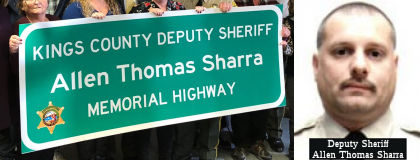 The portion of Route 41 between
Lincoln Avenue (KIN 32.420) and Lansing Avenue (KIN 33.590) is named the Kings
County Deputy Sheriff Allen Thomas Sharra Memorial Highway. Named
in memory of Deputy Sheriff Allen Thomas Sharra, who was born in March
1968 in Pittsburgh, PA. Upon graduating from high school, Allen joined the
United States Navy, where he served as an avionics mechanic until August
1995, when he was honorable discharged; after his discharge Allen
continued to serve the country as a sergeant in the National Guard. While
serving in the United States Navy, Allen was stationed at Naval Air
Station Lemoore in California and attended West Hills College Lemoore from
1991 to 1994, majoring in Administration of Justice. In 1993, Allen became
a reserve police officer for the City of Huron and attended the
Tulare-Kings Counties Basic Peace Officer Academy at College of the
Sequoias in 1998 and graduated in December 1998. Upon graduation from the
police academy, Allen was hired by the County of Kings in April 1999 as a
deputy sheriff, where he was assigned to headquarters patrol out of the
City of Hanford, California. Deputy Sheriff Allen Thomas Sharra was killed
in an automobile accident on December 27, 1999 in the line of duty when
his patrol car ran off a roadway and into a ditch; an Explorer scout who
was on a ride along with Deputy Sharra at the time was able to radio for
help, but Deputy Sharra was pronounced dead at the scene. Deputy Sharra
was responding to assist another officer who had located a stolen car in a
cotton field; the farm road that Deputy Sharra was driving down made a
sudden 90-degree turn without any warning signs; the cruiser left the
roadway and struck an embankment; the Explorer scout was injured in the
accident and transported to a local hospital in stable condition. Deputy
Sharra had served in law enforcement for nine years. Named by ACR 38, Res. Chapter 106, Statutes of 2019 on 07/08/19
The portion of Route 41 between
Lincoln Avenue (KIN 32.420) and Lansing Avenue (KIN 33.590) is named the Kings
County Deputy Sheriff Allen Thomas Sharra Memorial Highway. Named
in memory of Deputy Sheriff Allen Thomas Sharra, who was born in March
1968 in Pittsburgh, PA. Upon graduating from high school, Allen joined the
United States Navy, where he served as an avionics mechanic until August
1995, when he was honorable discharged; after his discharge Allen
continued to serve the country as a sergeant in the National Guard. While
serving in the United States Navy, Allen was stationed at Naval Air
Station Lemoore in California and attended West Hills College Lemoore from
1991 to 1994, majoring in Administration of Justice. In 1993, Allen became
a reserve police officer for the City of Huron and attended the
Tulare-Kings Counties Basic Peace Officer Academy at College of the
Sequoias in 1998 and graduated in December 1998. Upon graduation from the
police academy, Allen was hired by the County of Kings in April 1999 as a
deputy sheriff, where he was assigned to headquarters patrol out of the
City of Hanford, California. Deputy Sheriff Allen Thomas Sharra was killed
in an automobile accident on December 27, 1999 in the line of duty when
his patrol car ran off a roadway and into a ditch; an Explorer scout who
was on a ride along with Deputy Sharra at the time was able to radio for
help, but Deputy Sharra was pronounced dead at the scene. Deputy Sharra
was responding to assist another officer who had located a stolen car in a
cotton field; the farm road that Deputy Sharra was driving down made a
sudden 90-degree turn without any warning signs; the cruiser left the
roadway and struck an embankment; the Explorer scout was injured in the
accident and transported to a local hospital in stable condition. Deputy
Sharra had served in law enforcement for nine years. Named by ACR 38, Res. Chapter 106, Statutes of 2019 on 07/08/19
(Image sources: Hanford Sentinel, OfficerDown
Memorial Page)
The portion of Rout 41 between Elkhorn Avenue and Jensen Ave located in the City of Fresno (~ FRE M6.088 to FRE R21.109) is officially named the "Donald E. DeMers Highway". This segment was named in honor of Donald E. DeMers, who served as the first and only Executive Director of the Fresno County Transportation Authority. Mr. Donald E. DeMers graduated Magna Cum Laude from the University of North Dakota in 1966, with a bachelor's degree in Political Science; he earned a master's degree in Political Science and Public Administration from the University of North Dakota in 1971. During his tenure at the Fresno County Transportation Authority, Donald E. DeMers led the effort to construct freeways on Route 41, Route 180, and Route 168. Fresno County was one of the first counties statewide to become a self-help county, taxing itself to augment road construction throughout the county; Mr. DeMers led the county's representation on a committee that was formed of fellow self-help counties called the Self-Help Counties coalition throughout his time with the Fresno County Transportation Authority. Named by Senate Concurrent Resolution (SCR) 37, Resolution Chapter 138, on 9/8/2006.
The portion of Route 41 from the intersection with Elkhorn Avenue to the intersection with Ventura Avenue (~ FRE M6.088 to FRE R23.242) and from the intersection with Herndon Avenue to the Madera County Line (~FRE R30.468 to MAD 0.000) is named the "Yosemite Freeway". Named by Senate Concurrent Resolution 25, Chapter 85, 1997.
Scenic Route Freeway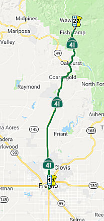 From Route 99 in Fresno to Yosemite National Park.
Post 1964 Signage HistoryIn 1963, this segment was defined as "(c) Route 99 near Fresno to Route 180. (d) Route 180 to Yosemite National Park.". In 1986, Chapter 928 combined these segments into "(c) Route 99 in Fresno to Yosemite National Park."
On February 23, 1995, the Commission approved Resolution HRA 95-3
adopting a revised alignment of SR 41 from Audubon Drive to 1.0 mile north
of Route 145 and declared it a freeway. The route adopted in 1995
was developed in conjunction with Madera County’s Rio Mesa Area Plan
and featured a segment of new route that significantly deviated from the
existing alignment, referred to hereinafter as the “Eastern
Divergence.” A freeway agreement between the Department and
Madera County (County) was executed on May 23, 1995 with plans to
construct future interchanges at Avenue 12 and Avenue 15 that would
service the Rio Mesa community. The route established in 1939 is currently
in use today. The Eastern Divergence segment is an unconstructed
portion of freeway as shown on the route location map. Since the 1995
route adoption, the County has revisited its plans for the Rio Mesa
community in an effort to improve upon the 1995 plan. In 2013, the
County began coordination with the Department to study an alignment for
Route 41 most compatible with the County’s updated land use
plan. As a result, the Department prepared a Project Initiation
Document exploring potential alignments along the corridor. The proposed
freeway route adoption for the Madera 41 South Expressway (06-Mad-41,
PM 1.15/7.6) discussed below will link the portions of the February
23, 1995 route adoption remaining in effect. The Eastern Divergence,
a portion of the February 23, 1995 freeway route adoption, will be
rescinded as part of this proposed freeway route adoption as shown on the
route location map. Construction of an expressway along the Eastern
Divergence is no longer preferred due to the significant environmental
impacts. Caltrans never acquired any right-of-way along the Eastern
Divergence alignment; therefore, there is no right-of-way to be disposed
of. On July 7, 2020, the Madera County Board of Supervisors adopted
resolution 2020-079 supporting the route adoption and rescission.
(Source: October 2020 CTC Agenda, Agenda Item
2.3a.(1))
Pre 1964 Signage HistoryIn 1934, Route 41 was signed along the route from Cambria to Yosemite Park, via Paso Robles and Fresno.This segment was was LRN 125, defined in 1933.
Before the current routing was established, Route 41 entered via Elm Avenue, then followed C Street to Fresno Street, where it ran with Route 180 multiplexed northeast to Broadway (US 99), then Route 41 continued north with US 99 to Stanislaus Street, and then north on Stanislaus to Blackstone Avenue.
Tom Fearer (Max Rockatansky) did some more investigation into the historical routing of Route 41 in Fresno on the Old CA 180 and CA 41 surface alignments in Fresno post in Gribblenation, and came to the following conclusions (his post has detailed maps):
The original crossing of the San Joaquin River on what would become Route 41 was the 1889 Lanes Bridge. The original Lanes Bridge was located about
a mile up river north of the 1941 bridge roughly where Lanes Road ends
today at the San Joaquin River. The original Lanes Bridge was first called
the Yosemite Bridge but soon became known as the Lanes Bridge due Lanes
Station which was a general store in close proximity which opened in 1894.
In 1917 the original Lanes Bridge had a partial collapse but was quickly
repaired. By 1934 the original Lanes Bridge had become part of Route 41
but was considered obsolete even for the standards of the time. The
original 1934 alignment of Route 41 used modern Friant Road and Lanes Road
to cross the San Joaquin River via the original Lanes Bridge. The original
Lanes Bridge was heavily damaged in a 1937 flood along the San Joaquin
River but was once again repaired. It wasn't until the summer of 1940 when
an overloaded truck crashed through the road deck of that the use of the
original Lanes Bridge ended. Route 41 traffic was temporarily rerouted to
Friant over the 1906 North Fort Bridge until the 1941 Lanes Bridge was
opened. The original alignment of Route 41 was routed along what is now a
long abandoned alignment of Abby Street in the River Park neighborhood of
northern Fresno (near the annexed community of Pinedale). Abby Street once
crossed over what is now the Route 41 freeway to Friant Road. Route 41
followed an older alignment of Friant Road which has been repurposed as
part of the Lewis E. Eaton Trail along a ridge above the San Joaquin River
northward to Rice Road. Route 41 followed Rice Road to Lanes Road which
approached the 1889 Lanes Bridge on the south band of the San Joaquin
River.
(Source: Gribblenation Blog: 1889 Lanes Bridge Location (Old California State Route 41), 4/17/2019)
Friant Road from Herndon Avenue/Blackstone Avenue near Pinedale to Lanes
Road was added to the State Highway System during 1933 as a component of
LRN 125; it was signed as part of Sign Route 41 in 1934. Sign Route 41/LRN 125 crossed the San Joaquin River into Madera County via the 1889 Lanes
Bridge. The 1889 Lanes Bridge was partially destroyed by an
overloaded truck collapsing the road deck during 1940. Sign Route 41
was realigned onto a temporary detour north of Lanes Road via Friant Road
to Friant and the 1906 North Fork Road Bridge over the San Joaquin
River. In 1941, the new Lanes Bridge opened and Sign Route 41 was
realigned via the Blackstone Avenue extension. The realignment of
Route 41 onto the new Lanes Bridge took Friant Road out of the State
Highway System. The detour alignment of California State Route 41 to
Friant via Friant Road is described as having been five miles longer than
the new highway.
(Source: Gribblenation Blog (Tom Fearer), "Friant Road (former California State Route 41)", 5/10/2023)
According to Tom Fearer, from Coarsegold the route of LRN 125 originally
took the following route towards Sugar Pine:
(Source: Gribblenation Blog, "Old California State Route 41 on Road 425C, Road 425B, and Road 425A/Old Yosemite Road", 7/28/2020)
The 1935 Division of Highways Map of Madera County shows Route 41/LRN 125 bypassing Road 425A/Old Yosemite Road in favor of it's current
alignment north of Oakhurst.
(Source: Gribblenation Blog, "Old California State Route 41 on Road 425C, Road 425B, and Road 425A/Old Yosemite Road", 7/28/2020)
It appears that Route 41 had a different routing in 1935 near Oakhurst:
On the 1935 Map of Madera County, the current crossing crossing of the
Fresno River west of the confluence with China Creek is instead east of
the confluence crossing on what are now Road 425B and Road 426 in
Oakhurst. Route 41 can be seen traversing southbound from Oakhurst on Road
425B towards Coarsegold on the 1935 Madera County Map.
(Source: Gribblenation Blog: Old California State Route 41 on Road 425B, 2/2/2018)
The California Highway Commission adopted the existing Route 41 as a
freeway from 0.5 mile north of Herndon Avenue to Madera County Road 10 E
on July 28, 1939.
(Source: October 2020 CTC Agenda, Agenda Item
2.3a.(1))
StatusCalTrans is in the midst of a number of projects to upgrade Route 41 in Fresno and the Fresno vicinity. Fresno has long had a deficit of freeways. This changed in 1986 when the electorate in Fresno County voted to raise their sales tax by .5% for twenty years to fund road improvements. At the time of the measure, Freeway Route 41 went only as far north as Bullard Avenue. The first project was to build the freeway to Woodward Park, just shy of the San Joaquin River (and the county line). In 1997, the Route 41 freeway was extended as far south as North Avenue. The plans are to have it expressway grade from there to Conejo or Mendocino Avenues (near Caruthers).
According to Joe Rouse in May 2001:
I traveled the 41 freeway from Jensen Ave. (~ FRE R21.113) north into Madera County. The new freeway extends quite a ways south of Jensen but I didn't have time to travel it. There are still Route 41 shields on Route 99 between Jensen and the interchange with the Route 41 freeway. Prior to the completion of the Route 41 freeway south of Route 99, Jensen Ave. was designated as Route 41 between Route 99 and Elm Ave.The extension north into Madera County starts on the west side of the old highway. Parts of the old road remain there, including the San Joaquin River bridge. The new freeway is 4 lanes but the new bridges across the river look like they are built to accommodate 3 lanes in each direction. The old road continues north, parallel to the new freeway, up to a large interchange that looks out of place since it is in an area with very little development..only the Valley Children's Hospital, is out there. However, this interchange has signals and ramp metering. Future development is apparently being planned. Just north of there the freeway becomes a super-2 and runs east of the old alignment, which has been renamed and signed as Business Route 41. The super-2 rejoins the old alignment at Avenue 12.
2007 CMIA. The following project on Route 41 in Fresno County was submitted to the Corridor Mobility Improvement Account for funding: expansion of the route to eight lanes from Divisadero to Shields ($95M) (~ FRE R23.704 to FRE R26.466). Not recommended for funding.
In July 2010, the California Transportation Commission approved the last bit of funding for the Route 41/Route 168/Route 180 interchange project (~ FRE R24.507), which will build a system of new ramps with overpasses to separate streams of traffic that now merge and diverge in an often chaotic scene. Two other project on Route 41 also are getting under way. One adds a new lane to the outside between Herndon and Bullard avenues to better accommodate entering and exiting traffic. The other involves installing ramp meters at four sites between Ashlan and Bullard avenues.
In November 2010, the CTC approved for future consideration of funding a project in Fresno County that will construct new braided ramps between Route 41 and Route 168 in the city of Fresno (~ FRE R24.522). The project is programmed in the 2010 State Highway Operation and Protection Program. Construction is estimated to begin in Fiscal Year 2010-11. Total estimated project cost is $55,000,000 for capital and support. The project will mitigate potential impacts to noise to a less than significant level by building soundwalls at four locations.
In August 2011, it was reported that Caltrans completed installation of three ramp-metering systems: one at McKinley Avenue (~ FRE R25.28), and the other two at Shields Avenue (~ FRE R26.466). The average daily traffic volume on Route 41 at each of these locations is about 125,000 vehicles. The $2.5 million project was financed entirely by the American Recovery and Reinvestment Act of 2009 (Recovery Act).
Shaw Avenue Widening (06-Fre-41, PM R27.6/R28.6)
") The following project was included in the final adopted 2018 SHOPP in March 2018: PPNO 6879. 06-Fresno-41 R27.6/R28.3. On Route 41 Near Fresno, from the northbound Ashlan Avenue onramp to the
northbound Shaw Avenue offramp. Construct northbound auxiliary lane and
add an additional lane to the Shaw Avenue offramp. Begin Con: 2/18/2022.
Total Project Cost: $22,957K.
The following project was included in the final adopted 2018 SHOPP in March 2018: PPNO 6879. 06-Fresno-41 R27.6/R28.3. On Route 41 Near Fresno, from the northbound Ashlan Avenue onramp to the
northbound Shaw Avenue offramp. Construct northbound auxiliary lane and
add an additional lane to the Shaw Avenue offramp. Begin Con: 2/18/2022.
Total Project Cost: $22,957K.
In June 2018, the City of Fresno posted that they will
be widening the northbound off-ramp of Route 41 at Shaw Avenue to provide
an improved travel way for motorists beginning Monday, June 4 through
Thursday, September 13, 2018. There will be intermittent lane closures on
the northbound off-ramp and on eastbound Shaw Avenue.
(Source: City of Fresno Facebook Page, 6/1/2018)
In January 2020, the CTC approved for future
consideration of funding a project located on Route 41 in the City of
Fresno, Fresno County that proposes to construct a northbound auxiliary
lane. The proposed project will also widen the Shaw Avenue
northbound off-ramp and construct a sound wall along the Shaw Avenue
off-ramp. This project addresses the increase in traffic congestion and
rear-end collisions at this project location. This project would improve
traffic operations on mainline Route 41 and the northbound Route 41
off-ramp to Shaw Avenue. The estimated total cost of the proposed project
is $23.1
million and is fully funded. The project is currently programmed in the
2018 SHOPP for an estimated total of $23.0 million which includes
Construction (capital and support) and Right of Way (capital and support).
Construction is estimated to begin in 2021-22. The CTC also approved the
following pre-construction allocation: 06-Fre-41 R27.6/R28.3. PPNO 6879.
ProjID 0617000103. EA 0W170. Route 41 near Fresno, from the northbound
Ashlan Avenue onramp to the northbound Shaw Avenue offramp.
Construct northbound auxiliary lane and add an additional lane to the Shaw
Avenue offramp. (Concurrent consideration of funding under
Resolution E-20-05; January 2020.) PS&E $2,400,000 R/W Sup $150,000
(Source: January 2020 CTC Agenda, Agenda Item
2.2c.(1), 2.5b.(2a) #16)
The 2020 SHOPP, approved in May 2020, included the
following Mobility item of interest (carried over from the 2018 SHOPP):
06-Fresno-41 PM R27.6/R28.3 PPNO 6879 Proj ID 0617000103 EA 0W170. Route 41 Near Fresno, from the northbound Ashlan Avenue onramp to the northbound
Shaw Avenue offramp. Construct northbound auxiliary lane and add an
additional lane to the Shaw Avenue offramp. Programmed in FY21-22, with
construction scheduled to start in April 2022. Total project cost is
$22,957K, with $14,707K being capital (const and right of way) and $8,250K
being support (engineering, environmental, etc.),
(Source: 2020 Approved SHOPP a/o May 2020)
In June 2022, it was reported that the CTC approved
$16.5 million for a project on Route 41 in Fresno, from the northbound
Ashlan Avenue on-ramp to the northbound Shaw Avenue off-ramp, that will
construct a northbound auxiliary lane, add an additional lane to the Shaw
Avenue off-ramp, and extend the turn pockets at the end of the Shaw Avenue
off-ramp. However, that report was wrong, as in June 2022, the CTC
approved the following construction phase SHOPP allocation: $20,101,000.
06-Fre-41 R27.6/R28.3 R27.4/R28.5. PPNO 06-6879;
ProjID 0617000103; EA 0W170. Route 41 Near Fresno, from the northbound
Ashlan Avenue onramp to the northbound Shaw Avenue offramp.
Outcome/Output: Construct northbound auxiliary lane, add an additional
lane to the Shaw Avenue offramp, and extend the turn pockets at the end of
Shaw Avenue offramp to reduce congestion and improve highway operations
and mobility. Future consideration of funding approved under Resolution
E-20-05; January 2020. Allocation: CON ENG $4,400,000; CONST $14,700,000.
(Source: Sierra Sun Times, 6/30/2022; June 2022 CTC Agenda, Agenda Item 2.5b.(1) #16)
![[TCRP 95]](maps/041-trcp-95.jpg) Improvement of the Friant Road Interchange (~ FRE R31.718) in Fresno, including
addition of an auxiliar lane and operational improvements, is TCRP Project
#95. The project is to improve the operation of northbound Route 41 from
Herndon Avenue to Friant Road. The project is to construct a median lane
from El Paso Avenue to Friant Road, construct an auxiliary lane from
Herndon Avenue to Friant Road, construct a second auxiliary lane from El
Paso Avenue to Friant Road, and widen Friant Road to accommodate the two
auxiliary lanes. Due to a reduction in cost for Right-of-Way, in February
2006 the CTC considered redistribution of $424,000 in TCRP funds to
ongoing work in Plans, Specifications, and Estimates (PS&E). PS&E
was completed in August 2006, and expenditures were lower than originally
estimated. The $230,000 surplus is needed for Construction due to
increased cost in asphalt concrete and structural concrete. The project is
being constructed in two segments. The first segment, funded with
$9,376,000 from the State Highway Operation and Protection Program
(SHOPP), will be completed in December 2006. Construction of the second
segment will be funded with $8,300,000 in TCRP funds. Estimated completion
is in FY 2010/2011. The mitigated negative environmental impact
declaration was recieved in July 2007.
Improvement of the Friant Road Interchange (~ FRE R31.718) in Fresno, including
addition of an auxiliar lane and operational improvements, is TCRP Project
#95. The project is to improve the operation of northbound Route 41 from
Herndon Avenue to Friant Road. The project is to construct a median lane
from El Paso Avenue to Friant Road, construct an auxiliary lane from
Herndon Avenue to Friant Road, construct a second auxiliary lane from El
Paso Avenue to Friant Road, and widen Friant Road to accommodate the two
auxiliary lanes. Due to a reduction in cost for Right-of-Way, in February
2006 the CTC considered redistribution of $424,000 in TCRP funds to
ongoing work in Plans, Specifications, and Estimates (PS&E). PS&E
was completed in August 2006, and expenditures were lower than originally
estimated. The $230,000 surplus is needed for Construction due to
increased cost in asphalt concrete and structural concrete. The project is
being constructed in two segments. The first segment, funded with
$9,376,000 from the State Highway Operation and Protection Program
(SHOPP), will be completed in December 2006. Construction of the second
segment will be funded with $8,300,000 in TCRP funds. Estimated completion
is in FY 2010/2011. The mitigated negative environmental impact
declaration was recieved in July 2007.
In September 2005, the CTC considered a proposal to relinquish the segement of former Route 41 (bypassed by the freeway construction) from 0.1 mile south of the Perrin Road Undercrossing to the San Joaquin River Bridge, consisting of superseded highway right of way. (~ FRE 33.085)
In June 2022, the CTC authorized relinquishment of right of way,
consisting of superseded State highway in the city of Fresno along Route 41 from 0.1 mile south of the city limit to the City of Fresno/County of
Madera limit. The City, by relinquishment agreement dated April 27, 2022,
agreed to waive the 90-day notice requirement and accept title upon
relinquishment by the State.
(Source: June 2022 CTC Agenda, Agenda Item
2.3c.(1))
In January 2015, the CTC approved for future consideration of funding a project that will seismically retrofit the Route 41 San Joaquin River Bridge (~ FRE 033.37) near Herndon and upgrade the railings on both this bridge and the San Joaquin River Overflow Bridge (~ MAD 000.08). The project is programmed in the 2014 State Highway Operation and Protection Program. The total estimated cost is $6,029,000 for capital and support. Construction is estimated to begin in Fiscal Year 2016-17. The scope, as described for the preferred alternative, is consistent with the project scope programmed by the Commission in the 2014 State Highway Operation and Protection Program.
In June 2021, the CTC authorized relinquishment of 3 segments of
right-of-way, consisting of superseded highway and collateral facilities
in the county of Madera along Route 41 between Avenue 8 through Avenue 12
(6-Mad-41-PM 0.0/2.5). The County, by a relinquishment agreement
dated May 6, 2021, agreed to waive the 90-day notice requirement and
accept title upon relinquishment by the State. See Attachment 3 for
the relinquishment location.
(Source: June 2021 CTC Agenda, Agenda Item 2.3c)
Madera 41 South Expressway (06-Mad-41, PM 1.15/7.6)
") 2007 CMIA. The following project on Route 41 in Madera County was
submitted to the Corridor Mobility Improvement Account for funding:
widening Route 41 between Ave 11 and Ave 12 (including an Ave 12
interchange) ($44.8M requested) (~ MAD 2.278 to MAD 3.226) . Not
recommended for funding.
2007 CMIA. The following project on Route 41 in Madera County was
submitted to the Corridor Mobility Improvement Account for funding:
widening Route 41 between Ave 11 and Ave 12 (including an Ave 12
interchange) ($44.8M requested) (~ MAD 2.278 to MAD 3.226) . Not
recommended for funding.
In May 2020, the CTC approved a new public road
connection for the following project for which a Final Environmental
Impact Report (FEIR) has been completed: Route 41 in Madera County.
Construct a four-lane divided expressway in Madera County. (PPNO 0R040)
(06-Mad-41, PM 1.15/7.6) The project is located in Madera County and
proposes to improve 6.1 miles of Route 41 from 0.8 mile south of the
Avenue 11 undercrossing to 1.4 miles north of Avenue 15. The purpose of
the proposed project is to address the increased traffic associated with
existing and planned development along Route 41 to and from Fresno and
Madera Counties. It also would relieve congestion and improve traffic flow
as well as identify a route for future transportation projects. The
project is funded through local funds originating with Madera County for a
total of $126,000,000. Construction is estimated to begin Fiscal Year
2022-2023.
(Source: May 2020 CTC Agenda, Agenda Item 2.2c.(7))
In October 2020, the CTC approved a route adoption and
future consideration of funding for the following project for which a
Final Environmental Impact Report (FEIR) has been completed: Route 41 in
Madera County. Construct a four-lane divided expressway in Madera
County. (06-Mad-41, PM 1.15/7.6) (PPNO 0R040) This project is
located in Madera County and proposes to improve 6.1 miles of Route 41
from 0.8 miles south of the Avenue 11 undercrossing to 1.4 miles north of
Avenue 15. The purpose of the proposed project is to address the increased
traffic associated with existing and planned development along Route 41 to
and from Fresno and Madera Counties. It also would relieve
congestion and improve traffic flow as well as identify a route for future
transportation projects. The project is funded through local funds
originating with Madera County for a total of $126,000,000. Construction
is estimated to begin Fiscal Year 2022- 2023. A copy of the FEIR has
been provided to Commission staff. Resources that may be impacted by
the project include noise, paleontological, and biological resources.
(Source: October 2020 CTC Agenda, Agenda Item
2.2c.(5))
 The October 2020 route adoption, per the resolution, will
allow the construction of a new expressway facility along the existing
highway alignment and the rescission of portion of an unconstructed
freeway in the county of Madera. The Madera 41 South Expressway
project proposes to address local traffic demand due to planned
developments along Route 41 in Madera County, north of the Fresno
metropolitan area. The project will construct a divided four-lane
expressway from Avenue 11 to north of Avenue 15 in two phases. Phase
1 of the project will construct a four-lane expressway from Avenue 11 to
Avenue 14 and a four-lane conventional highway from Avenue 14 to north of
Avenue 15. Phase 2 of the project will reconstruct the roadway and upgrade
the entire section to a four- lane expressway from Avenue 11 to north of
Avenue 15, then transition back to the existing two-lane conventional
highway. Avenue 12 and Avenue 15 will be the only two at-grade
intersections on Route 41. Based on forecasted traffic demand, it
was determined that construction of a freeway facility was not needed at
this time. Highway right-of-way will be reserved for a future
conversion of the facility to a six-lane freeway or expressway with
interchanges. The selected alignment is consistent with local
traffic circulation and land use and has the least effect on the
environment. The proposed freeway route adoption will link the portions of
the February 23, 1995 route adoption remaining in effect. The
Eastern Divergence, a portion of the February 23, 1995 freeway route
adoption, will be rescinded as part of this proposed freeway route
adoption as shown on the route location map. Construction of an
expressway along the Eastern Divergence is no longer preferred due to the
significant environmental impacts. The Department never acquired any
right-of-way along the Eastern Divergence alignment; therefore, there is
no right-of-way to be disposed of. On July 7, 2020, the Madera County
Board of Supervisors adopted resolution 2020-079 supporting the route
adoption and rescission. Development is underway in the Rio Mesa
planned community. The County is committed to move forward with
Phase 1 of the project. The total project cost, including phases 1
and 2, is estimated at $216 million. The recommended route is
compatible with the local land use plan. Therefore, the Department
and Madera County request the resolution be approved so that a superseding
freeway agreement can be executed between the two entities.
The October 2020 route adoption, per the resolution, will
allow the construction of a new expressway facility along the existing
highway alignment and the rescission of portion of an unconstructed
freeway in the county of Madera. The Madera 41 South Expressway
project proposes to address local traffic demand due to planned
developments along Route 41 in Madera County, north of the Fresno
metropolitan area. The project will construct a divided four-lane
expressway from Avenue 11 to north of Avenue 15 in two phases. Phase
1 of the project will construct a four-lane expressway from Avenue 11 to
Avenue 14 and a four-lane conventional highway from Avenue 14 to north of
Avenue 15. Phase 2 of the project will reconstruct the roadway and upgrade
the entire section to a four- lane expressway from Avenue 11 to north of
Avenue 15, then transition back to the existing two-lane conventional
highway. Avenue 12 and Avenue 15 will be the only two at-grade
intersections on Route 41. Based on forecasted traffic demand, it
was determined that construction of a freeway facility was not needed at
this time. Highway right-of-way will be reserved for a future
conversion of the facility to a six-lane freeway or expressway with
interchanges. The selected alignment is consistent with local
traffic circulation and land use and has the least effect on the
environment. The proposed freeway route adoption will link the portions of
the February 23, 1995 route adoption remaining in effect. The
Eastern Divergence, a portion of the February 23, 1995 freeway route
adoption, will be rescinded as part of this proposed freeway route
adoption as shown on the route location map. Construction of an
expressway along the Eastern Divergence is no longer preferred due to the
significant environmental impacts. The Department never acquired any
right-of-way along the Eastern Divergence alignment; therefore, there is
no right-of-way to be disposed of. On July 7, 2020, the Madera County
Board of Supervisors adopted resolution 2020-079 supporting the route
adoption and rescission. Development is underway in the Rio Mesa
planned community. The County is committed to move forward with
Phase 1 of the project. The total project cost, including phases 1
and 2, is estimated at $216 million. The recommended route is
compatible with the local land use plan. Therefore, the Department
and Madera County request the resolution be approved so that a superseding
freeway agreement can be executed between the two entities.
(Source: October 2020 CTC Agenda, Agenda Item
2.3a.(1))
Coursegold Passing Lanes (MAD 11.7/13.6)
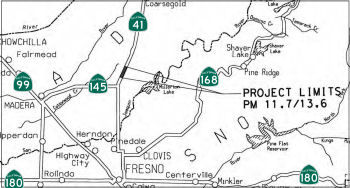 In December 2014, the CTC approved for future consideration of funding a project that will
construct passing lanes, outside shoulders, a median barrier, and rumble
strips on a portion of Route 41 near Madera (MAD 11.7/13.6). The project
is not fully funded. The project is programmed in the 2014 State
Transportation Improvement Program. The total estimated cost is
$22,148,000 for capital and support. Depending on the availability of
funds, construction is estimated to begin in Fiscal Year 2014-15. The
scope, as described for the preferred alternative, is consistent with the
project scope programmed by the Commission in the 2014 State
Transportation Improvement Program.
In December 2014, the CTC approved for future consideration of funding a project that will
construct passing lanes, outside shoulders, a median barrier, and rumble
strips on a portion of Route 41 near Madera (MAD 11.7/13.6). The project
is not fully funded. The project is programmed in the 2014 State
Transportation Improvement Program. The total estimated cost is
$22,148,000 for capital and support. Depending on the availability of
funds, construction is estimated to begin in Fiscal Year 2014-15. The
scope, as described for the preferred alternative, is consistent with the
project scope programmed by the Commission in the 2014 State
Transportation Improvement Program.
In March 2015, the CTC amended the funding allocation
for the Madera 41 Passing Lane. Near Coarsegold, from 0.3 mile north of
Road 208 to 2.2 miles north of Road 208 (~ MAD 11.698 to MAD 13.598).
Construct passing lane. CON ENG: $0 $2,577,000
CONST$11,047,000 $8,470,000.
In September 2007, the CTC approved a project near Coarsegold (~ MAD 28.068) for future consideration of funding. This project in Merced County will make improvements to a 198 acre parcel to be used for current and future mitigation near Coarsegold. The project is fully funded in the District 6 Minor Program.
In June 2020, the CTC approved the following CONST allocation for a
locally-administered LPP (Formulaic/Competitive) project: $5,000,000.
06-Mad-41 35.4/36.2. PPNO 06-6968 ProjID 0618000047 EA 0X410. Oakhurst
Midtown Connector. Oakhurst in north-central Madera County.
Construct a new, two-lane road connecting Route 41 with Indian Springs
Road. The new road will include a bridge over Nelder Creek approximately
365 feet in length. The project also includes new intersection
construction at Route 41 and Midtown Connector, including installation of
a traffic signal and widening of SR 41 from two to four travel lanes for
1,742 feet. The project includes intersection improvements at Road 27
(High School Road) and Indian Springs Road, including installation of a
threeway signal and two left-turn lanes on Road 427.
(Source: June 2020 CTC Agenda, Agenda Item
2.5s.(2b) #2)
The SAFETEA-LU act, enacted in August 2005 as the reauthorization of TEA-21, provided the following expenditures on or near this route:
NamingThe portion of Route 41 from the intersection with Elkhorn Avenue to the intersection with Ventura Avenue (~ FRE M6.088 to FRE R23.242) and from the intersection with Herndon Avenue to the Medera County Line (~FRE R30.468 to MAD 0.000) is named the "Yosemite Freeway". Named by Senate Concurrent Resolution 25, Chapter 85, 1997.
 The portion of Route 41 from the East Jensen Avenue
Overcrossing No. 42-268 (FRE R21.113) to the South Fresno Viaduct No.
42-226 (FRE R22.107) is named the “Tom Seaver Memorial Highway”.
It was named in memory of Tom Seaver, who was born in Fresno, California.
He attended Fresno High School and pitched for the school’s baseball
team, compensating for his lack of size and strength by developing great
control on the mound. Seaver joined the United States Marine Corps Reserve
on June 28, 1962, serving with the United States Aircraft, Fleet Marine
Force, Pacific, at Twentynine Palms, California, through July 1963, and,
after six months of active duty in the reserve, enrolled at Fresno City
College and remained a part-time member of the reserve until his
eight-year commitment ended in 1970. The University of Southern California
(USC) recruited Seaver to play college baseball and offered him a
scholarship after he pitched for the Alaska Goldpanners of Fairbanks in
the summer of 1964, during which he pitched and hit a grand slam to win a
game in a national tournament. As a sophomore in 1965, Seaver posted a
10-2 record pitching for the USC Trojans and was selected in the 10th
round of the 1965 Major League Baseball draft by the Los Angeles Dodgers,
who failed to sign Seaver to a contract. In 1966, the New York Mets were
awarded the right to sign Seaver, who made the Mets’ opening day
roster in 1967. In 1967, before his first All-Star game, Seaver introduced
himself to Hank Aaron, assuming Aaron would not know who he was, and asked
for his autograph, to which Aaron replied, “Kid, I know who you are,
and before your career is over, I guarantee you everyone in this stadium
will, too”. After an impressive 20-season career in Major League
Baseball, only Seaver and Walter Johnson had compiled 300 wins, 3,000
strikeouts, and earned run averages under 3.00, and Seaver had the third
most strikeouts, 3,640, in Major League Baseball history, which is now
sixth all time. Seaver is tied with Nolan Ryan for the seventh-most
shutouts in Major League Baseball history, holds the record for
consecutive 200-strikeout seasons with nine, spanning from 1968 to 1976,
inclusive, and set records by striking out 10 consecutive batters and
making 16 opening-day starts. The Mets retired Seaver’s uniform
number 41 in 1988 in a Tom Seaver Day ceremony, making him the
franchise’s first player to be so honored. Seaver was elected to the
Baseball Hall of Fame on January 7, 1992, with the then-highest percentage
of votes for induction with 98.84 percent of the vote, being named on 425
out of 430 ballots. Seaver is one of two players enshrined in the Baseball
Hall of Fame with a Mets cap on his plaque, along with Mike Piazza, and
was also inducted into the New York Mets Hall of Fame, the Marine Corps
Sports Hall of Fame, and the Cincinnati Reds Hall of Fame. On September
28, 2006, ESPN chose Seaver as the “Hometown Hero” for the
Mets franchise. Seaver made a return to Shea Stadium during the
“Shea Goodbye” closing ceremony on September 28, 2008, where
he threw out the final pitch in the history of the stadium to Piazza, and,
along with Piazza, he opened the Mets’ new home stadium, Citi Field,
with the ceremonial first pitch on April 13, 2009. In 2019, New York City
renamed 126th Street, the street outside Citi Field, Seaver Way and
changed the ballpark’s address to 41 Seaver Way, a salute to the
number he wore throughout his career. The 2013 Major League Baseball
All-Star Game was dedicated to Seaver, and he concluded the introduction
of the starting lineups ceremony by throwing out the ceremonial first
pitch. In 1999, Sporting News ranked Seaver 32nd on its list of the 100
greatest baseball players of all time, the only player on the list to have
spent a majority of his career with the Mets. In 2016, ESPN ranked Seaver
34th on its list of the greatest Major League Baseball players of all
time, while The Athletic ranked him the 41st greatest player of all time
in 2020. In retirement, Tom and Nancy returned to California to pursue
their dream of raising grapes in Napa Valley; and he worked daily in his
vineyard and lived in Napa valley for over 20 years before his passing in
2020. Named by Assembly Resolution ACR 52, Res. Chapter 136, Statutes of 2021, 09/17/21.
The portion of Route 41 from the East Jensen Avenue
Overcrossing No. 42-268 (FRE R21.113) to the South Fresno Viaduct No.
42-226 (FRE R22.107) is named the “Tom Seaver Memorial Highway”.
It was named in memory of Tom Seaver, who was born in Fresno, California.
He attended Fresno High School and pitched for the school’s baseball
team, compensating for his lack of size and strength by developing great
control on the mound. Seaver joined the United States Marine Corps Reserve
on June 28, 1962, serving with the United States Aircraft, Fleet Marine
Force, Pacific, at Twentynine Palms, California, through July 1963, and,
after six months of active duty in the reserve, enrolled at Fresno City
College and remained a part-time member of the reserve until his
eight-year commitment ended in 1970. The University of Southern California
(USC) recruited Seaver to play college baseball and offered him a
scholarship after he pitched for the Alaska Goldpanners of Fairbanks in
the summer of 1964, during which he pitched and hit a grand slam to win a
game in a national tournament. As a sophomore in 1965, Seaver posted a
10-2 record pitching for the USC Trojans and was selected in the 10th
round of the 1965 Major League Baseball draft by the Los Angeles Dodgers,
who failed to sign Seaver to a contract. In 1966, the New York Mets were
awarded the right to sign Seaver, who made the Mets’ opening day
roster in 1967. In 1967, before his first All-Star game, Seaver introduced
himself to Hank Aaron, assuming Aaron would not know who he was, and asked
for his autograph, to which Aaron replied, “Kid, I know who you are,
and before your career is over, I guarantee you everyone in this stadium
will, too”. After an impressive 20-season career in Major League
Baseball, only Seaver and Walter Johnson had compiled 300 wins, 3,000
strikeouts, and earned run averages under 3.00, and Seaver had the third
most strikeouts, 3,640, in Major League Baseball history, which is now
sixth all time. Seaver is tied with Nolan Ryan for the seventh-most
shutouts in Major League Baseball history, holds the record for
consecutive 200-strikeout seasons with nine, spanning from 1968 to 1976,
inclusive, and set records by striking out 10 consecutive batters and
making 16 opening-day starts. The Mets retired Seaver’s uniform
number 41 in 1988 in a Tom Seaver Day ceremony, making him the
franchise’s first player to be so honored. Seaver was elected to the
Baseball Hall of Fame on January 7, 1992, with the then-highest percentage
of votes for induction with 98.84 percent of the vote, being named on 425
out of 430 ballots. Seaver is one of two players enshrined in the Baseball
Hall of Fame with a Mets cap on his plaque, along with Mike Piazza, and
was also inducted into the New York Mets Hall of Fame, the Marine Corps
Sports Hall of Fame, and the Cincinnati Reds Hall of Fame. On September
28, 2006, ESPN chose Seaver as the “Hometown Hero” for the
Mets franchise. Seaver made a return to Shea Stadium during the
“Shea Goodbye” closing ceremony on September 28, 2008, where
he threw out the final pitch in the history of the stadium to Piazza, and,
along with Piazza, he opened the Mets’ new home stadium, Citi Field,
with the ceremonial first pitch on April 13, 2009. In 2019, New York City
renamed 126th Street, the street outside Citi Field, Seaver Way and
changed the ballpark’s address to 41 Seaver Way, a salute to the
number he wore throughout his career. The 2013 Major League Baseball
All-Star Game was dedicated to Seaver, and he concluded the introduction
of the starting lineups ceremony by throwing out the ceremonial first
pitch. In 1999, Sporting News ranked Seaver 32nd on its list of the 100
greatest baseball players of all time, the only player on the list to have
spent a majority of his career with the Mets. In 2016, ESPN ranked Seaver
34th on its list of the greatest Major League Baseball players of all
time, while The Athletic ranked him the 41st greatest player of all time
in 2020. In retirement, Tom and Nancy returned to California to pursue
their dream of raising grapes in Napa Valley; and he worked daily in his
vineyard and lived in Napa valley for over 20 years before his passing in
2020. Named by Assembly Resolution ACR 52, Res. Chapter 136, Statutes of 2021, 09/17/21.
(Image source: NY Times/Associated Press)
 The segment of Route 41 from Golden State
Boulevard to Bullard Avenue (~ FRE R22.195 to FRE R29.448) in the County
of Fresno is officially named the "Dwight D. Eisenhower Memorial
Freeway". Dwight Eisenhower was the 34th President of the United
States, and is believed to be the driving force behind the interstate
system. He died in 1969. For more information, see President Eisenhower's
official biography or visit the Eisenhower Library. Originally, this segment was from Ventura Avenue to Herndon
Avenue, and was named by Senate Concurrent Resolution No. 42, Chapter 141,
in 1971. It was redesignated to be from Golden State Boulevard to Bullard
Avenue by Senate Concurrent Resolution No. 45, Resolution Chapter 1, on
February 1, 2016.
The segment of Route 41 from Golden State
Boulevard to Bullard Avenue (~ FRE R22.195 to FRE R29.448) in the County
of Fresno is officially named the "Dwight D. Eisenhower Memorial
Freeway". Dwight Eisenhower was the 34th President of the United
States, and is believed to be the driving force behind the interstate
system. He died in 1969. For more information, see President Eisenhower's
official biography or visit the Eisenhower Library. Originally, this segment was from Ventura Avenue to Herndon
Avenue, and was named by Senate Concurrent Resolution No. 42, Chapter 141,
in 1971. It was redesignated to be from Golden State Boulevard to Bullard
Avenue by Senate Concurrent Resolution No. 45, Resolution Chapter 1, on
February 1, 2016.
(Image source: Wikipedia)
 The portion of Route 41 from Bullard
Avenue to Herndon Avenue in the County of Fresno (~ FRE R29.448 to FRE
R30.468) is officially named the "Joe Levy Memorial Highway". It
was named in memory of Joe Levy, a prominent Fresno businessman and civic
leader, whose commitment to the Fresno area created an enduring legacy of
community and humanitarian service. His contributions include championing
women’s professional advancement and active involvement in local
organizations such as the Boy Scouts of America, the American Red Cross,
the Fresno Arts Council, and the Fresno Area Chamber of Commerce. Levy was
born in January 1932, in Fresno, and died in February 2014. Levy graduated
from Fresno High School in 1950, and he attended the University of
Southern California, Marshall School of Business, where he graduated in
1954. Levy began his career with Gottschalks as an Assistant Merchandise
Manager in 1956, became a Merchandise Manager in 1960, and became
Executive Vice President in 1972. He was named CEO and Chairman in 1982,
and was the third generation of the Gottschalk family to hold a top
executive post. Levy returned to Fresno and began his career with
Gottschalks, Gottschalks had one store in downtown Fresno. Under his
watch, he helped the independent store expand across Central California
and the West Coast, growing to about 80 stores and 29 specialty stores in
six western states. Under Levy’s guidance and personal involvement,
the company became renowned for its outstanding community service and
steadfast commitment to customer service and high business ethics. Levy
strongly supported civic participation among Gottschalk employees to
support an array of local organizations and programs, including, but not
limited to, the annual “Coats for Kids” campaign. Levy’s
list of leadership positions and accolades is lengthy. He won the Leon S.
Peters Award in 1989, the top honor for service to the community
recognized by the Fresno Chamber of Commerce. A former president of the
Fresno Chamber of Commerce, he was active in the Downtown Association of
Fresno, the Boys Club of Fresno County, the Fresno Arts Museum, the Fresno
Metropolitan Museum, and the Craig School of Business at Fresno State. He
received other awards including the City of Hope’s Spirit of Life
Award and the Fresno Advertising Federation Foundation’s J.U. Berry
Lifetime Achievement Award. He was inducted into the Clovis Hall of Fame
and in 1990 was voted third in the Fresno Bee’s Top 10 Guiding
Forces in Fresno with the headline “Joe Levy loves sales but reveres
highways.” Leadership positions he held include serving on the Board
of Trustees during the founding of the University of California, Merced,
the Business Advisor Council for the Craig School of Business at Fresno
State, the Executive Committee for the Fresno Business Council, as a board
member for the Fresno Economic Development Corporation, a board member for
the San Joaquin Political Academy, a cofounder and sustaining sponsor of
the annual Central California Women’s Conference, a Trustee and
Secretary of Community Hospitals of Central California, a leader in
successfully obtaining “All-American City” designation for
Fresno in 1967, a board member of the National Retail Federation, a board
member of the Fresno County Transportation Authority, and as past
president of the Fresno Host Lions Club. Levy dedicated his life to
serving the community as the notable head of Gottschalks and continued his
commitment to the community upon being appointed by Governor George
Deukmejian to the California Transportation Commission. He served on the
California Transportation Commission from March 9, 1983, to February 1,
1991, and was its Chairman in 1986. With his constant vision for the
future, Joe Levy was a driving force for successfully securing funding for
the expanding freeway system in Fresno and he aided in the development of
Route 168 and Route 180 that serve as integral transportation lines in
Fresno County. Named by Senate Concurrent Resolution No. 45, Resolution
Chapter 1, on February 1, 2016.
The portion of Route 41 from Bullard
Avenue to Herndon Avenue in the County of Fresno (~ FRE R29.448 to FRE
R30.468) is officially named the "Joe Levy Memorial Highway". It
was named in memory of Joe Levy, a prominent Fresno businessman and civic
leader, whose commitment to the Fresno area created an enduring legacy of
community and humanitarian service. His contributions include championing
women’s professional advancement and active involvement in local
organizations such as the Boy Scouts of America, the American Red Cross,
the Fresno Arts Council, and the Fresno Area Chamber of Commerce. Levy was
born in January 1932, in Fresno, and died in February 2014. Levy graduated
from Fresno High School in 1950, and he attended the University of
Southern California, Marshall School of Business, where he graduated in
1954. Levy began his career with Gottschalks as an Assistant Merchandise
Manager in 1956, became a Merchandise Manager in 1960, and became
Executive Vice President in 1972. He was named CEO and Chairman in 1982,
and was the third generation of the Gottschalk family to hold a top
executive post. Levy returned to Fresno and began his career with
Gottschalks, Gottschalks had one store in downtown Fresno. Under his
watch, he helped the independent store expand across Central California
and the West Coast, growing to about 80 stores and 29 specialty stores in
six western states. Under Levy’s guidance and personal involvement,
the company became renowned for its outstanding community service and
steadfast commitment to customer service and high business ethics. Levy
strongly supported civic participation among Gottschalk employees to
support an array of local organizations and programs, including, but not
limited to, the annual “Coats for Kids” campaign. Levy’s
list of leadership positions and accolades is lengthy. He won the Leon S.
Peters Award in 1989, the top honor for service to the community
recognized by the Fresno Chamber of Commerce. A former president of the
Fresno Chamber of Commerce, he was active in the Downtown Association of
Fresno, the Boys Club of Fresno County, the Fresno Arts Museum, the Fresno
Metropolitan Museum, and the Craig School of Business at Fresno State. He
received other awards including the City of Hope’s Spirit of Life
Award and the Fresno Advertising Federation Foundation’s J.U. Berry
Lifetime Achievement Award. He was inducted into the Clovis Hall of Fame
and in 1990 was voted third in the Fresno Bee’s Top 10 Guiding
Forces in Fresno with the headline “Joe Levy loves sales but reveres
highways.” Leadership positions he held include serving on the Board
of Trustees during the founding of the University of California, Merced,
the Business Advisor Council for the Craig School of Business at Fresno
State, the Executive Committee for the Fresno Business Council, as a board
member for the Fresno Economic Development Corporation, a board member for
the San Joaquin Political Academy, a cofounder and sustaining sponsor of
the annual Central California Women’s Conference, a Trustee and
Secretary of Community Hospitals of Central California, a leader in
successfully obtaining “All-American City” designation for
Fresno in 1967, a board member of the National Retail Federation, a board
member of the Fresno County Transportation Authority, and as past
president of the Fresno Host Lions Club. Levy dedicated his life to
serving the community as the notable head of Gottschalks and continued his
commitment to the community upon being appointed by Governor George
Deukmejian to the California Transportation Commission. He served on the
California Transportation Commission from March 9, 1983, to February 1,
1991, and was its Chairman in 1986. With his constant vision for the
future, Joe Levy was a driving force for successfully securing funding for
the expanding freeway system in Fresno and he aided in the development of
Route 168 and Route 180 that serve as integral transportation lines in
Fresno County. Named by Senate Concurrent Resolution No. 45, Resolution
Chapter 1, on February 1, 2016.
(Image sources: Twitter, Fresno Bee)
 The portion of Route 41 from Herndon Avenue in the City
of Fresno to Avenue 10 in Madera County (~FRE R30.468 to MAD 1.353) is
named the "Deputy David G. Graves Memorial Freeway". It was named
in memory of Deputy David G. Graves of the Fresno County Sheriff's Office,
who was killed on November 5, 1982, while in performance of his duties to
the citizens he was sworn to protect. Deputy Graves was a native of
Fresno, and a graduate of Hoover High School and Fresno City College.
Before entering law enforcement, Deputy Graves worked as a general
contractor and operated his own construction business. Deputy Graves
joined the Fresno County Sheriff's Office in 1979, having served as a
volunteer in the Sheriff's Search and Rescue Unit for two years prior to
becoming a deputy, and was assigned to the patrol division. Deputy Graves
was a dedicated officer who served his community and loved his profession.
On November 5, 1982, Deputy Graves was on routine patrol on Shaw Avenue in
Fresno west of Route 99 in a marked patrol vehicle when his vehicle was
struck by a pickup truck driven by an intoxicated 28-year-old Clovis man
that had run a stop sign, with the collision resulting in severe head
injuries to Deputy Graves that led to his death prior to arrival at the
Valley Medical Center. Named by Assembly Concurrent Resolution (ACR) 61,
Resolution Chapter 90, on 9/1/2009.
The portion of Route 41 from Herndon Avenue in the City
of Fresno to Avenue 10 in Madera County (~FRE R30.468 to MAD 1.353) is
named the "Deputy David G. Graves Memorial Freeway". It was named
in memory of Deputy David G. Graves of the Fresno County Sheriff's Office,
who was killed on November 5, 1982, while in performance of his duties to
the citizens he was sworn to protect. Deputy Graves was a native of
Fresno, and a graduate of Hoover High School and Fresno City College.
Before entering law enforcement, Deputy Graves worked as a general
contractor and operated his own construction business. Deputy Graves
joined the Fresno County Sheriff's Office in 1979, having served as a
volunteer in the Sheriff's Search and Rescue Unit for two years prior to
becoming a deputy, and was assigned to the patrol division. Deputy Graves
was a dedicated officer who served his community and loved his profession.
On November 5, 1982, Deputy Graves was on routine patrol on Shaw Avenue in
Fresno west of Route 99 in a marked patrol vehicle when his vehicle was
struck by a pickup truck driven by an intoxicated 28-year-old Clovis man
that had run a stop sign, with the collision resulting in severe head
injuries to Deputy Graves that led to his death prior to arrival at the
Valley Medical Center. Named by Assembly Concurrent Resolution (ACR) 61,
Resolution Chapter 90, on 9/1/2009.
(Image source: Officer Down Memorial Page)
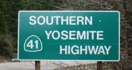 The portion of this route from the Fresno county line (MAD 0.000 to MPA 4.918)
to Yosemite National Park is named the "Southern Yosemite Highway".
It was named by Assembly Concurrent Resolution 27, Chapter 69, in 1989. It
was named by location.
The portion of this route from the Fresno county line (MAD 0.000 to MPA 4.918)
to Yosemite National Park is named the "Southern Yosemite Highway".
It was named by Assembly Concurrent Resolution 27, Chapter 69, in 1989. It
was named by location.
(Image source: Sierra News Online)
 The portion of Route 41 from PM MPA 1.841 at the
Mariposa-Madera county line to PM MPA 4.918 at the entrance to Yosemite
National Park, is named the "Buffalo Soldiers Memorial Highway".
In 1866, the United States Congress created six segregated regiments that
were ultimately consolidated into four African American regiments: the 9th
and 10th Cavalry and the 24th and 25th Infantry. African American army
regiments that had been dispatched westward fought in the Indian Wars and
these soldiers were eventually given the name Buffalo Soldiers by the
Cheyenne and other Plains Indians. Although historians have recorded the
service of these Buffalo Soldiers on the western frontier, their service
in some national parks has been nearly forgotten. The United States Army
served as the official administrator of Yosemite and Sequoia National
Parks between 1891 and 1913. In that capacity, it helped create a model
for park management as we know it today. Buffalo Soldiers were among the
first park rangers and back country rangers patrolling parts of the west.
Approximately 500 Buffalo Soldiers, mainly from the 24th Infantry and 9th
Cavalry, served in Yosemite National Park and Sequoia National Park. Their
duties ranged from evicting poachers and timber thieves to extinguishing
forest fires. They also oversaw the construction of roads, trails, and
other infrastructure. Commanding officers of the United States Army became
acting military superintendents for these national parks with two troops
of cavalry assigned to each park. Each troop was made up of approximately
60 men. The presence of these troops invigorated the local economy and the
soldiers acting as official stewards of park lands brought a sense of law
and order to the mountain wilderness. Among their many accomplishments,
the troops assigned to Yosemite National Park oversaw the building of an
arboretum near the south fork of the Merced River in 1904. One scholar
considered the area to contain the first marked nature trail in the United
States’ national park system. Named by Assembly Concurrent
Resolution (ACR) 174, Res. Chapter 134, Statutes of 2016, on August 23,
2016.
The portion of Route 41 from PM MPA 1.841 at the
Mariposa-Madera county line to PM MPA 4.918 at the entrance to Yosemite
National Park, is named the "Buffalo Soldiers Memorial Highway".
In 1866, the United States Congress created six segregated regiments that
were ultimately consolidated into four African American regiments: the 9th
and 10th Cavalry and the 24th and 25th Infantry. African American army
regiments that had been dispatched westward fought in the Indian Wars and
these soldiers were eventually given the name Buffalo Soldiers by the
Cheyenne and other Plains Indians. Although historians have recorded the
service of these Buffalo Soldiers on the western frontier, their service
in some national parks has been nearly forgotten. The United States Army
served as the official administrator of Yosemite and Sequoia National
Parks between 1891 and 1913. In that capacity, it helped create a model
for park management as we know it today. Buffalo Soldiers were among the
first park rangers and back country rangers patrolling parts of the west.
Approximately 500 Buffalo Soldiers, mainly from the 24th Infantry and 9th
Cavalry, served in Yosemite National Park and Sequoia National Park. Their
duties ranged from evicting poachers and timber thieves to extinguishing
forest fires. They also oversaw the construction of roads, trails, and
other infrastructure. Commanding officers of the United States Army became
acting military superintendents for these national parks with two troops
of cavalry assigned to each park. Each troop was made up of approximately
60 men. The presence of these troops invigorated the local economy and the
soldiers acting as official stewards of park lands brought a sense of law
and order to the mountain wilderness. Among their many accomplishments,
the troops assigned to Yosemite National Park oversaw the building of an
arboretum near the south fork of the Merced River in 1904. One scholar
considered the area to contain the first marked nature trail in the United
States’ national park system. Named by Assembly Concurrent
Resolution (ACR) 174, Res. Chapter 134, Statutes of 2016, on August 23,
2016.
(Image sources; Trail Posse, AsAm News)
In local usage, this segment is called "Wawona Road".
Historically, this segment is supposedly part of the "Sierra to the Sea" Highway, although other records indicate that name belongs to Route 198.
Named StructuresThe Route 41 Lincoln Avenue overcrossing (Bridge 42-0144, PM FRE R017.10) is called the "Richard Allen Flores Memorial Bridge". It was named by Senate Concurrent Resolution 102, Chapter 170 in 1998. Richard Allen Flores lost his life in a construction accident on January 13, 1998, while working on the Lincoln Avenue overcrossing bridge, which bears his memorial.
 The Route 41/Route 99 interchange near PM FRE R021.79 in
downtown Fresno is named the "Rosa Parks Interchange". Rosa Parks
(born February 4, 1913, in Tuskegee, Alabama) is considered the "Mother of
the Modern Day Civil Rights Movement". This fame started when she was
arrested on December 1, 1955, in Montgomery, Alabama, for refusing to give
up her seat on a bus to a white man. Her arrest was the impetus for a
boycott of Montgomery buses, led by Dr. Martin Luther King, Jr., and
joined by approximately 42,000 African Americans for 381 days. On November
13, 1956, the United States Supreme Court ruled that Montgomery's
segregation law was unconstitutional, and on December 20, 1956, Montgomery
officials were ordered to desegregate buses. Rosa Parks refusal to
surrender her seat in compliance with Montgomery's segregation law
inspired the civil rights movement, which has resulted in the breakdown of
numerous legal barriers and the lessening of profound discrimination
against African Americans in this country. Her courage and conviction laid
the foundation for equal rights for all Americans and for the Civil Rights
Act of 1964. Rosa Parks was the first woman to join the Montgomery chapter
of the NAACP, and was an active volunteer for the Montgomery Voters
League. She cofounded the Rosa and Raymond Parks Institute for Self
Development in 1987 with Elaine Easton Steele to motivate and direct youth
to achieve their highest potential through the "Pathways to Freedom"
program. She is the recipient of many awards including the Presidential
Medal of Freedom, the nation's highest civilian honor, the Congressional
Gold Medal of Honor, the highest honor Congress can bestow upon a
civilian, and the first International Freedom Conductor Award from the
National Underground Railroad Freedom Center. Named by Senate Concurrent
Resolution 3, Chaptered 7/16/2003, Chapter 98.
The Route 41/Route 99 interchange near PM FRE R021.79 in
downtown Fresno is named the "Rosa Parks Interchange". Rosa Parks
(born February 4, 1913, in Tuskegee, Alabama) is considered the "Mother of
the Modern Day Civil Rights Movement". This fame started when she was
arrested on December 1, 1955, in Montgomery, Alabama, for refusing to give
up her seat on a bus to a white man. Her arrest was the impetus for a
boycott of Montgomery buses, led by Dr. Martin Luther King, Jr., and
joined by approximately 42,000 African Americans for 381 days. On November
13, 1956, the United States Supreme Court ruled that Montgomery's
segregation law was unconstitutional, and on December 20, 1956, Montgomery
officials were ordered to desegregate buses. Rosa Parks refusal to
surrender her seat in compliance with Montgomery's segregation law
inspired the civil rights movement, which has resulted in the breakdown of
numerous legal barriers and the lessening of profound discrimination
against African Americans in this country. Her courage and conviction laid
the foundation for equal rights for all Americans and for the Civil Rights
Act of 1964. Rosa Parks was the first woman to join the Montgomery chapter
of the NAACP, and was an active volunteer for the Montgomery Voters
League. She cofounded the Rosa and Raymond Parks Institute for Self
Development in 1987 with Elaine Easton Steele to motivate and direct youth
to achieve their highest potential through the "Pathways to Freedom"
program. She is the recipient of many awards including the Presidential
Medal of Freedom, the nation's highest civilian honor, the Congressional
Gold Medal of Honor, the highest honor Congress can bestow upon a
civilian, and the first International Freedom Conductor Award from the
National Underground Railroad Freedom Center. Named by Senate Concurrent
Resolution 3, Chaptered 7/16/2003, Chapter 98.
(Image source: The Negro Woman in History Blog)
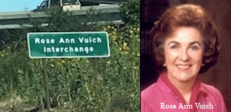 The Route 41/Route 180 interchange near PM FRE R024.50 is named the "Rose Ann
Vuich Interchange". Rose Ann Vuich was the state senator that secured the
funding for completion of Route 41 and Route 180. Rose Ann Vuich was
elected to the Senate in 1976 to represent the 15th Senate District,
comprised of Tulare and Kings Counties, approximately half of Fresno
County, and a portion of Kern County. She was born in January 1927, in
Cutler, California, and wa sa lifetime resident of Tulare County. Not many
initially took notice when she ran for a vacant state Senate seat in 1976,
as the area voted Republican in most elections. However, she scored one of
the biggest upsets in the state that year when she narrowly defeated
Ernest Mobley, a 10 year Republican Assemblyman, in the general election.
Vuich quickly became popular in her district for her unassuming manner and
her political independence. She broke with her party on agricultural and
law enforcement issues on several occasions. Her Democratic colleagues
tolerated that because of the conservative constituency she represented.
However, she was willing to stand up to conservatives, angering popular
Republican Governor George Deukmejian in 1989 when she voted against
confirming his chosen appointee for state Treasurer when the post became
vacant. Rose Ann Vuich was the first woman elected to the California
Senate; and served with distinction on the Senate Transportation
Committee, the Senate Rural Caucus, and as chair of the Senate Select
Committee on Rural Issues. Her role in transportation and rural issues led
her to being an active supporter of the construction of the Fresno County
portions of Route 41, the southern gateway to Yosemite National Park, and
Route 180, the gateway to Sequoia and Kings Canyon National Parks. Studies
to construct both freeways began in 1955 and construction of the first
portion of Route 41 began in 1970. In 1976, the funding for the completion
of those freeways was uncertain; and as a Senator, Rose Ann Vuich
championed "constructing the road that leads to nowhere to the road that
leads to somewhere". Additionally, Rose Ann Vuich used her leadership
skills to secure funding for the completion of the construction of Route 41 and Route 180; and the routes were reopened to traffic on September 20,
1982. Named by Senate Concurrent Resolution 25, Chapter 85, in 1997.
The Route 41/Route 180 interchange near PM FRE R024.50 is named the "Rose Ann
Vuich Interchange". Rose Ann Vuich was the state senator that secured the
funding for completion of Route 41 and Route 180. Rose Ann Vuich was
elected to the Senate in 1976 to represent the 15th Senate District,
comprised of Tulare and Kings Counties, approximately half of Fresno
County, and a portion of Kern County. She was born in January 1927, in
Cutler, California, and wa sa lifetime resident of Tulare County. Not many
initially took notice when she ran for a vacant state Senate seat in 1976,
as the area voted Republican in most elections. However, she scored one of
the biggest upsets in the state that year when she narrowly defeated
Ernest Mobley, a 10 year Republican Assemblyman, in the general election.
Vuich quickly became popular in her district for her unassuming manner and
her political independence. She broke with her party on agricultural and
law enforcement issues on several occasions. Her Democratic colleagues
tolerated that because of the conservative constituency she represented.
However, she was willing to stand up to conservatives, angering popular
Republican Governor George Deukmejian in 1989 when she voted against
confirming his chosen appointee for state Treasurer when the post became
vacant. Rose Ann Vuich was the first woman elected to the California
Senate; and served with distinction on the Senate Transportation
Committee, the Senate Rural Caucus, and as chair of the Senate Select
Committee on Rural Issues. Her role in transportation and rural issues led
her to being an active supporter of the construction of the Fresno County
portions of Route 41, the southern gateway to Yosemite National Park, and
Route 180, the gateway to Sequoia and Kings Canyon National Parks. Studies
to construct both freeways began in 1955 and construction of the first
portion of Route 41 began in 1970. In 1976, the funding for the completion
of those freeways was uncertain; and as a Senator, Rose Ann Vuich
championed "constructing the road that leads to nowhere to the road that
leads to somewhere". Additionally, Rose Ann Vuich used her leadership
skills to secure funding for the completion of the construction of Route 41 and Route 180; and the routes were reopened to traffic on September 20,
1982. Named by Senate Concurrent Resolution 25, Chapter 85, in 1997.
(Image source: Gribblenation; Find a Grave)
The Lanes Bridge, Bridge 41-0040, SAN JOAQUIN RIVER OVERFLOW, MAD PM 000.08, is unlike the bridges around it, as
it dates back to 1941. The original Lanes Bridge was completed in 1889 and
was a steel truss design. The original Lanes Bridge was located about a
mile up river north of the 1941 bridge roughly where Lanes Road ends today
at the San Joaquin River. The original Lanes Bridge was first called the
Yosemite Bridge but soon became known as the Lanes Bridge due to Lanes
Station, which was a general store in close proximity which opened in
1894. In 1917 the original Lanes Bridge had a partial collapse but was
quickly repaired. By 1934 the original Lanes Bridge had become part of
Route 41 but was considered obsolete even for the standards of the time.
The original 1934 alignment of Route 41 used modern Friant Road and Lanes
Road to cross the San Joaquin River via the original Lanes Bridge. The
original Lanes Bridge was heavily damaged in a 1937 flood along the San
Joaquin River but was once again repaired. It wasn't until the summer of
1940 when an overloaded truck crashed through the road deck of that the
use of the original Lanes Bridge ended. Route 41 traffic was temporarily
rerouted to Friant over the 1906 North Fort Bridge until the 1941 Lanes
Bridge was opened. The design of the 1941 Lanes Bridge is traditional Art
Deco concrete design which was a common bridge design by the California
Division of Highways prior to the mid-20th Century. There is a good
article, with pictures, on the Gribblenation Blog.
(Source: Gribblenation - Lanes Bridge, CaltransBridge
Log)
 The Route 41 Fresno River overcrossing
(Bridge 42-4122) is called Kristopher's Crossing. It was named in
memory of 9 year old Kristopher Charles Turner, a third grader at Oakhurst
Elementary School. Kristopher was reported missing on May 23, 2004, and
his murdered body was discovered later that day inside a concrete culvert
under a bridge that crosses the Fresno River, Department of Transportation
Bridge 4122. Renaming the bridge under which Kristopher's body was found
Kristopher's Crossing "reflects the boy's crossing over to a better
place". Named by Assembly Concurrent Resolution (ACR) 65, Resolution
Chapter 82, on 7/11/2006. (Note: This really appears to be bridge 42-0022,
MAD PM 035.30)
The Route 41 Fresno River overcrossing
(Bridge 42-4122) is called Kristopher's Crossing. It was named in
memory of 9 year old Kristopher Charles Turner, a third grader at Oakhurst
Elementary School. Kristopher was reported missing on May 23, 2004, and
his murdered body was discovered later that day inside a concrete culvert
under a bridge that crosses the Fresno River, Department of Transportation
Bridge 4122. Renaming the bridge under which Kristopher's body was found
Kristopher's Crossing "reflects the boy's crossing over to a better
place". Named by Assembly Concurrent Resolution (ACR) 65, Resolution
Chapter 82, on 7/11/2006. (Note: This really appears to be bridge 42-0022,
MAD PM 035.30)
(Image source: Find a Grave)
Scenic Route[SHC 263.4] From Route 49 near Oakhurst to Yosemite National Park.
Freeway[SHC 253.3] From Route 99 near Fresno to Route 180; and from Route 180 to Yosemite National Park. Added to the Freeway and Expressway system in 1959.
 Classified Landcaped Freeway
The following segments are designated as Classified Landscaped Freeway:
| County | Route | Starting PM | Ending PM |
| Fresno | 41 | R19.91 | R21.11 |
| Fresno | 41 | R22.50 | R23.08 |
| Fresno | 41 | R23.25 | R30.70 |
| Fresno | 41 | R30.70 | R31.68 |
 Exit Information Other WWW Links
 Interregional Route
[SHC 164.12] Between Route 1 and Yosemite National Park.
 Statistics
Overall statistics for Route 41:
 Pre-1964 Legislative Route
The route that become LRN 41 was first defined in 1905 by Chapter 598, which authorized "...locating, surveying, and constructing a public highway from the General Grant National Park in Fresno County, thence E-ly into Kings Canyon..."
In 1909, Chapter 223 stated "The highway now completely located and surveyed, and partially completed ... from the General Grant National Park to the floor of the Kings River Canyon is hereby made a state highway..."
In 1919, the Third Bond Issue provided funding for the Kings River Canyon State Road. In 1933, the route was extended from [LRN 4] near Fresno to General Grant National Park, and from [LRN 4] near Fresno to [LRN 5] near Tracy. By 1935, when the route was codified, the definition was:
Legislation approved in 1963 would have changed "General Grant National Park" to the "General Grant Grove Section", but that change was overtaken by the 1963 renumbering by Chapter 385.
Signage along this route was as follows:
This was signed as Route 33 between Tracy and Los Banos and between the vicinity of Santa Rita Park and 2 mi NE of Mendota. It was signed as Route 180 from 2 mi NE of Mendota into Fresno. The Route 33 portion was defined in 1933; the Route 180 portion was defined in 1919.
Since 1964, some portions of this segment were deleted. The portion between Route 152 and I-5 (originally part of CA 33) was deleted in 1970, when former Route 207 (LRN 121) was resigned as Route 33 from Route 152 to I-5. The deleted portion was Ingomar Grade and Henry Miller Road. Additionally, the portion between I-205 in Tracy and I-5 was deleted from the state highway system in 1976.
This was signed as Route 180. "General Grant National Park" is General Grant Grove in Sequoia National Park. This was defined in 1933.
This was signed as Route 180. This was defined in 1905.
© 1996-2020 Daniel P. Faigin.
Maintained by: Daniel P. Faigin
<webmaster@cahighways.org>.
 Route 40
 Route 42