
 California Highways:
 The California State Highway code defines a number of different types of highways:
 A
statewide system of freeways and expressways and connections thereto,
creating a comprehensive system of access-controlled freeways and
expressways throughout the State. Within this system a "freeway" is
defined as a divided arterial highway for through traffic with full
control of access and with grade separations at intersections, while the
"expressway" is defined as an arterial highway for through traffic which
may have partial control of access, but which may or may not be divided or
have grade separations at intersections.[SHC Sect 250-252, 257]
A
statewide system of freeways and expressways and connections thereto,
creating a comprehensive system of access-controlled freeways and
expressways throughout the State. Within this system a "freeway" is
defined as a divided arterial highway for through traffic with full
control of access and with grade separations at intersections, while the
"expressway" is defined as an arterial highway for through traffic which
may have partial control of access, but which may or may not be divided or
have grade separations at intersections.[SHC Sect 250-252, 257]
Designation as a freeway does not mean the route is constructed to freeway standards; rather, it was planned to be a freeway.
Expressways are a unique beast. Most formal expressways are County Routes, usually in the San Francisco Bay Area (specifically, Santa Clara county). The Santa Clara County Expressway Network is a 377-mile network of extra-wide streets that haul commuters from the Almaden Valley to Milpitas to Palo Alto. They carry nearly 498,000 vehicles a day. More than four of five valley residents use the expressways at least several days a week, and 37 percent of commuters take an expressway to work. County leaders turned to the expressway system when building high-speed highways took too long. In the early 1950s as the Cold War heated up and defense industries blossomed throughout Santa Clara County, thousands moved here for high-paying jobs. But traffic lights still dotted US 101 and Route 237, and I-280 wouldn't be completed until 1965. Route 85 wouldn't get off the drawing board until 1994. County leaders decided to build their own roads, passing a property tax increase in 1960 to begin construction of the first phase of expressways. A second phase—upgrading the current roads into freeways—was to have been paid by a second bond measure in 1974, but it was defeated.
 Those portions of the state highway system which, together with the
adjacent scenic corridors, require special scenic conservation treatment.
[SHC Section 260].
Those portions of the state highway system which, together with the
adjacent scenic corridors, require special scenic conservation treatment.
[SHC Section 260].
To protect and enhance the natural beauty of California highway corridors, the state Legislature created the State Scenic Highway Program in 1963. The first Scenic Highway designation was awarded in 1965 for a 72.3-mile segment of Route 1 in Monterey County. Note that many highway corridors are eligible for Scenic Highway status, but receiving an official designation requires the local government to apply to Caltrans for approval and adopt a Corridor Protection Program. The local governing body must develop and implement measures that strictly limit development and control outdoor advertising along the scenic corridor. As of 2017, In California, 70 segments of 42 state highways have official recognition as a State Scenic Highway. In addition, following the same program requirements that apply to state routes, eight segments of seven county roads in California have obtained state recognition as an officially designated County Scenic Highway.
According to data released by Caltrans in 2019, only 28 percent of the roadways that have been listed as eligible have ended up becoming Scenic Highways. None of them span multiple counties.
The Scenic Highway designation reflects strong support by area residents
and local government, including a written proposal and a detailed visual
assessment of the route. The city and the county must formally endorse the
application to Caltrans. A Scenic Highway must “traverse an area of
outstanding scenic beauty” and is defined by the breadth of the
natural landscape that can be seen by its travelers, the quality of that
landscape, and the extent to which land development fetters that
enjoyment. Only legislators can make that decision by enacting their
opinion into law. And only transportation authorities can ensure it,
looking for policies put in practice to limit visual intrusions to a max
of 25 percent across the scenic driving landscape.
(Partial source: Davis
Enterprise, "Almost Scenic 128", Sept 2020)
Being eligible isn’t enough. A local government such as Napa County must prepare a scenic highway proposal that includes a survey of the visual highlights. The proposals must be discussed at a public meeting. Then the paperwork goes to Caltrans. Once Caltrans accepts the proposal, the local government creates a corridor protection program that details how the scenic views will be protected. Then Caltrans decides whether to designate or not.
The legislative definition is just the start of the process, just like
the legislative definition of something as part of the Freeway and
Expressway system doesn't mean it is actually a freeway. A route can
become part of the signed state scenic highway system provided it
qualifies visually and five standards have been put in place. These
standards are ensured by the Department of Transportation (Caltrans)
through an iterative approval process with local authorities that focuses
on a “corridor protection program” to shape land use. This
starts when local officials — either as a group or county-by-county
— conduct an assessment of which stretches of roadway are eligible
for official designation according to that max 25 percent visual intrusion
rule. They must then submit a “Resolution of Intent package”
— which includes a letter from the local governing body, maps of the
corridor and existing zoning, an overlay of development within that
corridor, a narrative of the routes scenic elements and a videotape
— all sent to Caltrans via the local district office.
(Partial source: Davis
Enterprise, "Almost Scenic 128", Sept 2020)
If a Caltrans committee approves the package, in part or, perhaps less
likely, in its entirety, a recommendation to designate the highway as
scenic will be forwarded to the Caltrans Director who makes the final
call. Sometimes the director will request additional information or
clarification, but typically the director will officially designate the
route per committee request. Once designated, Caltrans monitors the
corridor at least every five years and may pull the designation if the
corridor enforcement program has become ineffectual. If the package is
ultimately not approved, Caltrans says “it is not advisable to
continue seeking official designation.”
(Partial source: Davis
Enterprise, "Almost Scenic 128", Sept 2020)
Threre is a collection of Scenic Highway Guidelines at http://www.dot.ca.gov/hq/LandArch/16_livability/scenic_highways/guidelines/scenic_hwy_guidelines_04-12-2012.pdf (link currently broken in Caltran's accessibiliy update -- it should be available on this page after the update). After being defined in the SHC as eligible, cities and/or counties (hereafter referred to as local governing bodies) must develop and implement a Corridor Protection Program containing five legislatively required elements, generally accepted as land use planning standards. That then has to be reviewed and approved before there is signage.
As for the Corridor Protection Program:
The five legislatively required elements of corridor protection are:
Designation of highways signed as Scenic Highways requires a partnership
between local landowners and their local government, and in turn that
local government with the state government, is exactly what lawmakers say
they envisioned with the spirit of the Scenic Highway law: to encourage
buy-in at the local level in order to protect California’s
diminishing natural resources while at the same time increasing the value
of those natural resources to Californians. The establishing legislation
recognized then that a growing California would mean a growing number of
highways and that scenic roadway may be developed into freeways where it
should not be. By regulating site planning, such as what’s permitted
to be built on hillsides, the state legislation says “giving the
utmost attention to scenic values” is the only way to “with
the co-operative efforts of local government agencies” to together
“not only add to the pleasure of the residents of this State”
but also “play an important role in encouraging the growth of the
recreation and tourist industries upon which the economy of many areas of
this State depend.”
(Partial source: Davis
Enterprise, "Almost Scenic 128", Sept 2020)
There's a lot more information on scenic highways at https://dot.ca.gov/programs/design/lap-landscape-architecture-and-community-livability/lap-scenic-highways
Note that there’s no special funding, immediate tourism windfall,
or accolade that comes with a “scenic highway” becoming a
“Scenic Highway.” The only benefit is the sign, emblazoned
with a poppy.
(Partial source: Davis
Enterprise, "Almost Scenic 128", Sept 2020)
 Those portions of the state highway system that (1)
were constructed prior to 1945; (2) have been recognized by CalTrans or
the Office of Historic Preservation in the Department of Parks and
Recreation as having historical significance, including notable landmarks,
historical sites, or natural or human achievements that exist or that
occurred during the original construction of the parkway or in the
immediately adjacent land area through which the parkway currently passes;
(3) are bounded on one or both sides by federal, state, or local parkland,
Native American lands or monuments, or other open space, greenbelt areas,
natural habitat or wildlife preserves, or similar acreage used for or
dedicated to historical or recreational uses; and (4) are traversed, at
the time of designation and by the department's best count or estimate
using existing information, by not less than 40,000 vehicles per day on an
annual daily average basis. [SHC Section 280]
Those portions of the state highway system that (1)
were constructed prior to 1945; (2) have been recognized by CalTrans or
the Office of Historic Preservation in the Department of Parks and
Recreation as having historical significance, including notable landmarks,
historical sites, or natural or human achievements that exist or that
occurred during the original construction of the parkway or in the
immediately adjacent land area through which the parkway currently passes;
(3) are bounded on one or both sides by federal, state, or local parkland,
Native American lands or monuments, or other open space, greenbelt areas,
natural habitat or wildlife preserves, or similar acreage used for or
dedicated to historical or recreational uses; and (4) are traversed, at
the time of designation and by the department's best count or estimate
using existing information, by not less than 40,000 vehicles per day on an
annual daily average basis. [SHC Section 280]
 A classified
landscaped freeway is a section of freeway with planting that meets
the criteria of the State
Outdoor Advertising Regulations, Section 2500-2513, and assists in
the control of Outdoor Advertising Displays. This is more than just having
vegetation around the freeway. Plantings that consist of native vegetation
and revegetation that are considered “functional” are not
"classified landscaping". The designation affects off-premise displays.
Off-premise displays advertise offsite products and businesses. Caltrans
has no control over on-premise displays, which advertise the
on-site business. Signs that are adjacent to a section of landscaped
freeway can only be for on-premise displays. Next to a landscaped freeway,
off-premise displays are not allowed per the Outdoor Advertising
Regulations and Caltrans would not approve a permit for the off-premise
panel.
A classified
landscaped freeway is a section of freeway with planting that meets
the criteria of the State
Outdoor Advertising Regulations, Section 2500-2513, and assists in
the control of Outdoor Advertising Displays. This is more than just having
vegetation around the freeway. Plantings that consist of native vegetation
and revegetation that are considered “functional” are not
"classified landscaping". The designation affects off-premise displays.
Off-premise displays advertise offsite products and businesses. Caltrans
has no control over on-premise displays, which advertise the
on-site business. Signs that are adjacent to a section of landscaped
freeway can only be for on-premise displays. Next to a landscaped freeway,
off-premise displays are not allowed per the Outdoor Advertising
Regulations and Caltrans would not approve a permit for the off-premise
panel.
To qualify for landscape status, plantings must be (a) within the state right of way; (b) continuous (no gaps ≥ 200’); (c) ornamental (not functional); (d) at least 1000' long; (e) on at least one side of the freway; and (f) require reasonable maintenance. Ornamental plants are lawns, trees, shrubs, flowers, or other plantings designed primarily to improve the aesthetic appearance of the highway. Inert material specifically placed to highlight the ornamental vegetation is considered part of the ornamental vegetation. In contrast, functional plantings are vegetation planted primarily for soil erosion control, traffic safety, reduction of fire hazards, covering soundwalls or fences; and traffic noise abatement or other non-ornamental purposes. A single row of plantings in the median is considered a functional planting. Reasonable maintenance means that a plant when planted requires maintenance on a regular basis to maintain it in a healthy and attractive condition. The fact that as a plant matures, it may require less maintenance than when first planted is not interpreted to mean it does not require reasonable maintenance. Maintenance means any of the following: watering, fertilizing, spraying, cultivating, pruning, cutting, mowing, replacing, weed control, washing, pest control, disease control, litter removal, or other similar plant care procedures.
Outdoor advertising displays require a permit from Caltrans if they are within 660 feet from the edge of the right-of-way and viewed primarily by persons traveling on the main-traveled way of the freeway. Permit Requirements are available on the Internet at https://dot.ca.gov/programs/traffic-operations/oda/permit. Some of the requirements include: the location must be zoned commercial or industrial; the applicant must have property owner consent; the applicant must have building permit from local agency; there must be a business activity within 1,000 feet of proposed display; and the display may not be located adjacent to a landscaped freeway or scenic highway. In addition the display must be 500 feet from any other permitted display and not exceed 1,200 square feet in size. More details can be found in the briefing at http://www.dot.ca.gov/hq/LandArch/lsfwy/pdf/Landscaped_Freeways_and_Outdoor_Advertising_Displays.pdf.
However, there are some special rules when relocating displays. Independent of the definition of a Landscaped Freeway, if an agreement to relocate advertising displays from within one area of a city or county to an area adjacent to a freeway right-of-way has been entered into between a city or county and the owner of an advertising display, then a “landscaped freeway” does not include the median of a freeway right-of-way. Digital billboards (message centers) may also be allowed: A relocated advertising display may be converted to a message center pursuant to a relocation agreement. The department shall issue a permit, without any additional consideration, for any display that is being placed pursuant to a relocation agreement with another governmental entity if the relocated display conforms with the provisions of this section.
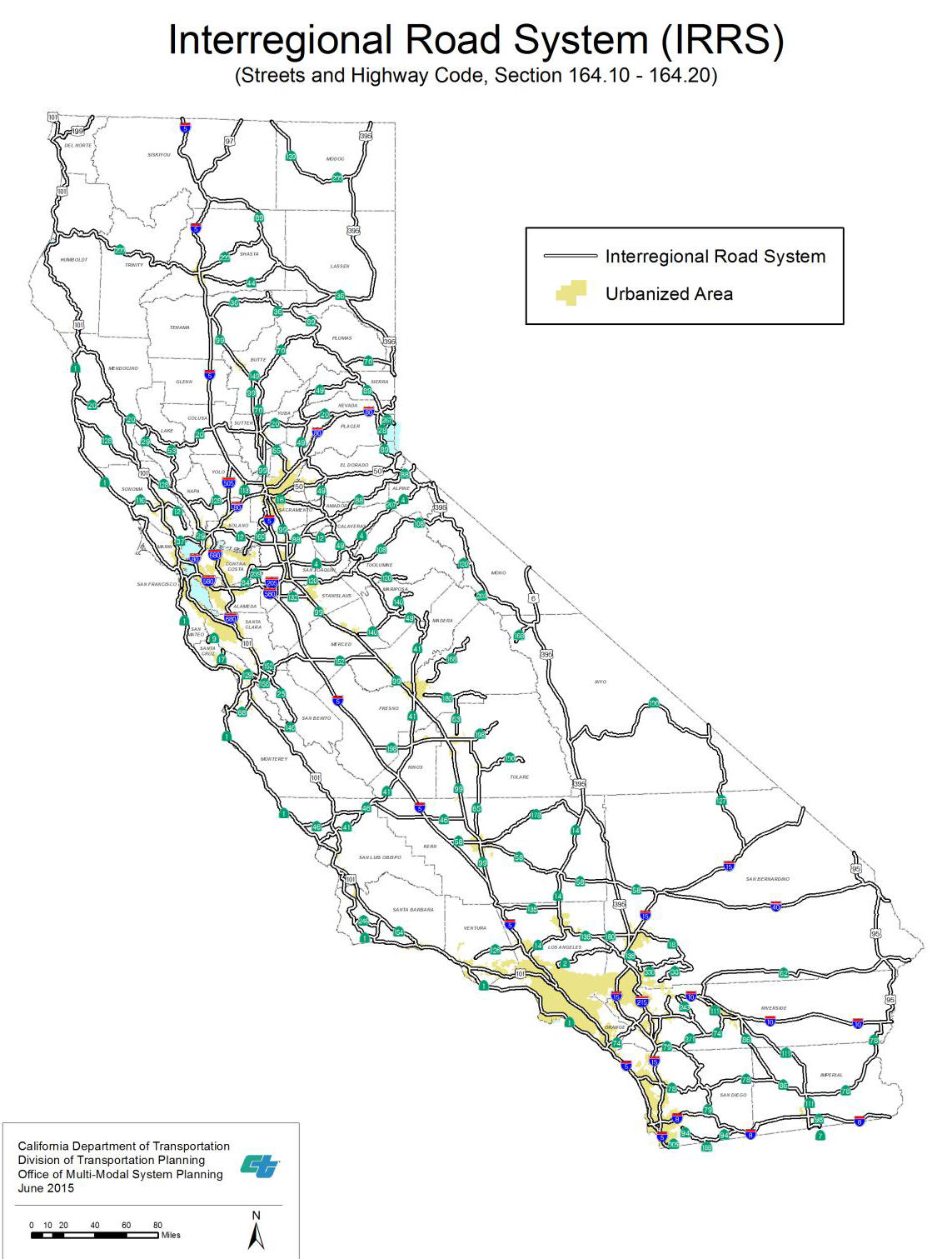
 A system of roads or projects on which construction
can be started not later than June 30, 2000, that will provide the most
adequate interregional road system to all economic centers in the state.
The projects shall be on eligible routes identified and be located outside
the boundaries of urbanized areas of over 50,000 population as designated
by the most recent census of the Bureau of the Census, except as necessary
to provide connections for continuation of the routes within those urban
areas. [SHC Section 164.3]
A system of roads or projects on which construction
can be started not later than June 30, 2000, that will provide the most
adequate interregional road system to all economic centers in the state.
The projects shall be on eligible routes identified and be located outside
the boundaries of urbanized areas of over 50,000 population as designated
by the most recent census of the Bureau of the Census, except as necessary
to provide connections for continuation of the routes within those urban
areas. [SHC Section 164.3]
According to the 2015 Interregional Transportation Strategic Plan, the Interregional Road System (IRRS) was first identified by statute in 1989 as part of the Blueprint Legislation (a ten-year transportation funding package that created by AB 471, SB 300, and AB 973). The IRRS, a subset of the 265 State Highway System (SHS) routes, provides connectivity between California’s major regions. There are currently 93 statutory IRRS routes, with many interstates among them. The IRRS was conceived as part of the larger effort to address the State’s critical transportation system funding and development needs. The implementation of IRRS improvements is dependent on prioritization of State transportation revenues. In addition, SB 45 requires that the Interregional Transportation Improvement Plan (ITIP) include a specific allocation of funds to be programmed on IRRS routes in non-urbanized areas.
 After World War II, a nationwide movement was started
to pay tribute to the nation's armed forces, by designatng various state
and national routes as "Blue Star Memorial Highways". In 1945, the
National Council of State Garden Clubs, Inc., approved the Blue Star
Memorial Highway Marker program. California Garden Clubs, Inc. accepted
the program in 1947, when the California Legislature designed US 40 (now
I-80) and US 99.
After World War II, a nationwide movement was started
to pay tribute to the nation's armed forces, by designatng various state
and national routes as "Blue Star Memorial Highways". In 1945, the
National Council of State Garden Clubs, Inc., approved the Blue Star
Memorial Highway Marker program. California Garden Clubs, Inc. accepted
the program in 1947, when the California Legislature designed US 40 (now
I-80) and US 99.
For more information, see the Caltrans page on Blue Star Memorial Highways. Before July 1, 1964, there was a disconnect between the route numbers as signed on the highways, and the legislative route numbers. Thus, although a freeway might be signed as Interstate 5, it was LRN 238.
![]() Return to California Highways Home Page
Return to California Highways Home Page
© 1996-2020 Daniel P.
Faigin.
Maintained by: Daniel P.
Faigin <webmaster@cahighways.org>.