
 California Highways:
Click here for a key to the symbols used. An explanation of acronyms may be found at the bottom of the page.
 Routing
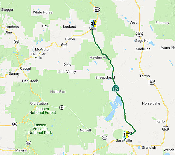 From Route 36 in Susanville to Route 299 near Adin.
 Post 1964 Signage History
As defined in 1963, this segment was "(a) Route 36 near Susanville to Route 299 near Adin."
In 1981, Chapter 292 changed the origin to "(a) Route 36 near
in Susanville to …".
 Pre 1964 Signage History
Between Susanville and Horse Lake Road, this segment was a 1957 extension of LRN 20. Horse Lake Road was originally part of LRN 20, but is now not part of the state highway system.
Route 139 was LRN 216, defined in 1959, to Route 299. It was not signed as part of the 1934 initial state signage of highways, but was signed by 1963.
 Status
During the May 2018 CTC Meeting, the CTC was informed of the following
SHOPP amendment: $5,015,000 02-Las-139 6.2/7.3. On Route 139 Near
Susanville, from 1.1 miles south to Antelope Radio Street. Outcome/Output:
Improve safety by realigning roadway curves, widening lane and shoulder
widths, and improving sight distance. This project will reduce the number
and severity of collisions. The amendment is to CON ENG: $660,000
$771,000.
(Source: CTC Meeting, May 2018 Agenda Item 2.5f(3) Proj 2)
In March 2019, the CTC approved for future consideration of funding a
project is located on various locations along Route 299 and Route 139 in
Lassen and Modoc Counties (02-Las-299, PM 18.5/25.6, 02-Mod-299, PM
0.5/0.5, 1.1/1.8, 02-Mod-139, PM 0.1). This project proposes to reduce the
amount of distressed lane miles by restoring the roadway to a condition of
minimal maintenance for a 20-year design life. This proposed project
addresses the existing poor pavement condition, late stages of
deterioration, and the roadway’s substandard lighting. The project
also proposes widening shoulders, reconstruct driveway approaches, and
updating the Intelligent Transportation System (ITS) elements. This
project is fully funded and programmed in the 2018 SHOPP for approximately
$25.2 million, construction is estimated to begin in 2020. The scope, as
described for the preferred alternative, is consistent with the project
scope programmed by the Commission in the 2018 SHOPP.
(Source: March 2019 CTC Minutes, Agenda Item 2.2c.(1))
 Naming
For some reason, this is named Joint Highway 14. There appears to have been no connection with a route 14.
 National Trails
 This route is part of the Volcanic Legacy Scenic Byway All American Road.
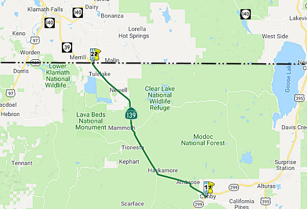 From Route 299 near Canby to the Oregon state line near Hatfield.
Post 1964 Signage HistoryThis segment is as defined in 1963.
Pre 1964 Signage HistoryThis segment was LRN 210, defined in 1939. It was not signed as part of the 1934 state signage of highways, but was signed starting in 1944.
Note that SE of Newell, a route diverges N called "Old Alturas Highway", rejoining Oregon 39 (a continuation of Route 139) E of Merrill.
Note: The following is summarized from Gribblenation Blog (Tom Fearer), “Oregon Route 39 and California State Route 139”, September 2021. See the blog post for more details, history, links to maps, and other artifacts and correspondence. Excerpted with permission.
OR 39 was added to the Oregon State Highway System as one of the original
Oregon State Highways as part of Dalles-California Highway #4 on November
27th, 1917. It ran from south of Klamath Falls to the California State
Line near Malin. As noted above, Route 139 was added to the
California state highway system as part of LRN 210 via 1939 Legislative
Chapter 338, which noted that it was added with the stipulation
“provided that the United States Government, through its agencies
the Bureau of Public Roads and Forest Service construct or reconstruct
with highway funds or any other funds made available by congress for
highway purposes within the state of California.” By 1939, LRN 210
was under construction by the Federal Government in Modoc National Forest
between Canby (US 299) north through Modoc County to the Oregon State Line
near Merrill. Also in 1939, Oregon's Klamath Falls-Malin Highway #50 was
spun off from Dalles-California Highway #4 south of Klamath Falls to the
California State Line near Malin, and OR 39 was realigned from Merrill to
the California State Line via Hatfield Highway #426. 1943 California
Legislative Chapter 964 repealed the 1939 stipulations of LRN 210,
reflecting the completion of the new highway through Modoc National Forest
that subsequently was turned over to the California Division of Highways.
The completion of the new highway through Modoc National Forest by the
Bureau of Public Roads likely was a priority during World War II due to
the internment camp located at Tulelake. Route 139 appears on state
highway maps starting in 1944 aligned over LRN 210 from the Oregon State
Line through Modoc National Forest to US 299 near Canby; the numbering
seems to have been chosen to provide route continuity with OR 39 as Route 39 was already in use in Southern California.
(Source: Gribblenation Blog (Tom Fearer), “Oregon Route 39 and California State Route 139”, September 2021)
By 1956, the Susanville-Adin Highway was upgraded and was California's
longest Federal Aid Secondary highway completed to that date. It was
reconstructed as cooperative Joint Highway District #14 between Lassen
County, the Division of Highways and Bureau of Public Roads. In 1957,
Chapter 1911 added a segment of LRN 20 along Susanville-Adin Highway from
Route 36/LRN 29 in Susanville to US 395/LRN 73 to the State Highway
System. This extension of LRN 20 served as part of a future
extension of Route 139 between Route 36/LRN 29 and Horse Lake
Road. LRN 216 was defined in 1959 from LRN 20 north of
Susanville at Horse Lake Road north via Susanville-Adin Highway to US 299/LRN 28 near Adin. The 68 miles of Susanville-Adin Highway
north of Susanville to US Route 299/LRN 28 was announced as being annexed
into the State Highway System in 1959.
(Source: Gribblenation Blog (Tom Fearer), “Oregon Route 39 and California State Route 139”, September 2021)
StatusIn May 2008, the CTC considered relinquishment of right of way in the county of Siskiyou, at Osborne Road, Havlina Road, Akins Road, Tschirky Road, and Walsh Road (Road No. 0U018), consisting of reconstructed and relocated county roads. (2-Sis-139-PM 1.0/4.0)
This route continues into Oregon as Oregon 39.
 Scenic Route
[SHC 263.7] Entire portion.
Pre 1964 Signage HistoryRoute 139 was not defined in the initial set of state signed routes in 1934.
 Freeway
[SHC 253.1] Entire route. Added to the Freeway and Expressway system in 1959.
 Interregional Route
[SHC 164.16] Between Route 299 and the Oregon state line.
 Other WWW Links
 Statistics
Overall statistics for Route 139:
 Pre-1964 Legislative Route
In 1933, Chapter 767 defined the route from "Taft-Greenfield Road to [LRN 33] near Wasco" as part of the state highway system. In 1935, it was added to the highway code as LRN 139, with the definition:
This definition remained unchanged until the 1963 renumbering. The route ran from US 399 (present-day Route 119) to US 466 (present-day Route 46) near Wasco. It was signed as Route 43.
© 1996-2020 Daniel P. Faigin.
Maintained by: Daniel P. Faigin
<webmaster@cahighways.org>.
 Route 138
 Route 140