
 California Highways:
Click here for a key to the symbols used. An explanation of acronyms may be found at the bottom of the page.
 Routing
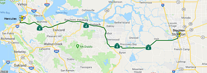 Route 80 in Hercules to Route 5 in Stockton via north of
Concord and via Antioch.
Route 80 in Hercules to Route 5 in Stockton via north of
Concord and via Antioch.
 Post 1964 Signage History
In 1963, this segment was defined to run from "Route 80 near Hercules to Route 99 near Stockton via north of Concord and via Antioch" by Chapter 385.
In 1990, the language was tightened slightly to refer to "in Hercules" by Chapter 1187.
In 1994, the segment was split into two portions: (a) Route 80 in Hercules to Route 5 in Stockton via north of Concord and via Antioch. (b) Route 5 to Route 99.
 Pre 1964 Signage History
The portion of this segment between Martinez and Route 5 was defined as part of the state highway system in 1931 as part of LRN 75.
It was signed as part of Route 4 (Jct. US 40 at Pinole [just S of Hercules] to Jct. Route 89 near Markleeville, via Stockton). It was cosigned with Route 24 from the junction with Route 24 to 4 mi E of Antioch (starting in 1935). The current portion between Concord and the Antioch Bridge was originally signed as Route 24; a different routing was signed as Route 4. In 1964, the section of former sign Route 24 from Concord to the Antioch Bridge was renumbered as Route 4.
Willow Pass Road, which is also part of Route 4 in Contra Costa County, had previously been a county road (since 1853). This highway served industrial traffic to and from Port Chicago, Pittsburg, and Antioch in the 1930s-1940s, especially during World War II. It became known as the Arnold Industrial Highway and John Muir Parkway. It became a state highway in 1933.
 In 1956, the San Francisco Examiner published the proposed lengthening of the freeway along
part of Sign Route 24 (Route 160) along Neroly Avenue to the Antioch
Bridge. This would connect to the co-signed Sign Route 4/Sign Route 24
(Route 4) routing that had been approved in 1949. As the map shows, the
pre-freeway routings were along A Street, 18th Street, Main Street, and
Empire Avenue for Sign Route 4, and Neroly Avenue and Bridgehead Avenue
for Sign Route 24 (Route 160).
In 1956, the San Francisco Examiner published the proposed lengthening of the freeway along
part of Sign Route 24 (Route 160) along Neroly Avenue to the Antioch
Bridge. This would connect to the co-signed Sign Route 4/Sign Route 24
(Route 4) routing that had been approved in 1949. As the map shows, the
pre-freeway routings were along A Street, 18th Street, Main Street, and
Empire Avenue for Sign Route 4, and Neroly Avenue and Bridgehead Avenue
for Sign Route 24 (Route 160).
(Source: San Francisco Examiner, 12/9/1956 via Joel Windmiller,
4/26/2023)
The alignment of Route 4 in San Joaquin County has some of the original
surface alignment still in use; however, the route of Route 4 in Contra
Costa County is substantially different. The specifics of the original
Contra Costa county routing are detailed in the Gribblenation blog "California State Route 4; west from I–5 through the San Joaquin River Delta and Diablo Range to I–80". That blog also notes:``Port Chicago as a way point on early Route 4 is interesting due to the 1944 Port
Chicago Disaster. Port Chicago was heavily damaged when the nearby Port
Chicago Naval Magazine suffered a large explosion of munitions in July
1944. 320 people were killed in the explosion at the Port Chicago Naval
Magazine which would ensure the demise of Port Chicago. In 1968 all
property in Port Chicago was purchased by the Federal Government as part
of a safety buffer for the Concord Naval Weapons loading docks on Suisun
Bay. Former Route 4 on Port Chicago Highway, Main Street and Waterfront
Road still exists as military roads that serve as the last evidence of the
community of Port Chicago.'' In a October 1935 Department of Public Works
Guide, Route24 was announced as being extended south to Oakland. This
extension included a multiplex of Route 4 near Oakley west through
Pittsburg where Route 24 split towards Concord. In 1938, a new planned
bypass route for LRN 106 of Port Chicago and Martinez first appears. In a
October of 1939 Department of Public Works Guide the new alignment of
Route 4/LRN 106 between Franklin Canyon Road east to Route 24 at Willow
Pass was announced as being completed. This new highway which was called
"Industrial Highway" served as a bypass of Martinez and Port Chicago.
(Source: Gribblenation Blog "California State Route 4; west from I–5 through the San Joaquin River Delta and Diablo Range to I–80")
The portion of this segment between Route 80 (US 40) and Route 24 was added to the state highway system in 1933 as part of LRN 106. The bypasses of Antioch and Brentwood were constructed after 1955, however, they were proposed by that date. The Gribblenation blog "California State Route 4; west from I–5 through the San Joaquin River Delta and Diablo Range to I–80" has a good chronology of how each individual segment was added to the highway, and how it was improved.
Stockton. Route 4 eastbound originally entered Stockton
via LRN 75 on Garwood Ferry Road. Route 4 eastbound multiplexed US 50/LRN 5 on Charter Way from McKinley Avenue east to Wilson Way.
From Wilson Way, Route 4 eastbound multiplexed US 99/LRN 4 on Mariposa
Road and split away at Farmington Road/LRN 75. See the entries of US 50
and Route 99 for the changes of those routes within Stockton. By 1951, the
Stockton Bypass had been completed. At that time, US 99/US 50/LRN 4
bypassed Wilson Way in favor of the Stockton Bypass. US 50/LRN 5
departed the US 99 and Stockton Bypass at Charter Way. Route 4
westbound went northward from Farmington Road onto a multiplex of US 99/LRN 4 on the Stockton Bypass to Charter Way. Route 4 departed the
Stockton Bypass at Charter Way where it began a multiplex through Stockton
on US 50/LRN 5. By 1967, US 50 and Route 99 multiplexed on the the fully
freeway grade Stockton Bypass south from Lodi towards Charter Way.
US 50 and Route 4 multiplexed west on Charter Way towards El Dorado
Street/Center Street. By 1975, I-5 was completed, and Route 4 was
left as the only route signed on Charter Way in Stockton. El Dorado
Street south of Charter Way was relinquished from the State Highway
System. Charter Way remained part of Route 4 into the early 1990s
when it was finally relinquished due to the Crosstown Freeway being
completed between Route 99 and I-5.
(Source: Gribblenation Blog (Tom Fearer), “The Lincoln Highway, US Route 99 and US Route 50 in Stockton”, May 2021)
 Status
I-80 near Hercules (apx 004 CC L0.106) to I-680 near Concord (apx 004 CC 12.723)
As of May 2002, the $86 million project to convert the 2-lane section of
Route 4 between I-80 in Hercules (apx 004 CC 0.046) and Cummings Skyway
(004 CC R4.661R) to four lanes has been completed. New westbound lanes
were built on a new alignment just north of the existing road, which was
converted for eastbound traffic. The new westbound alignment has been open
for a while, but each direction didn't have two lanes for the entire
section until May 15, 2002. . The project had been on the drawing board
for decades. This section of Route 4 is now much safer than it was just a
few years ago, since opposing traffic is separated and all cross-traffic
has been eliminated. However, it is not up to full freeway
standards: many intersections are full right turns instead of gentle on-
and off-ramps. Eventually, new eastbound lanes will be built, and the
current eastbound lanes (the original road) will revert to a two-way
frontage road. There is currently no funding for the full freeway
conversion project. However, the project is not completed. In particular,
the right lane eastbound is still marked exit-only at Sycamore Ave.
(including at the exit itself) even though it isn't any longer; the speed
limits are marked inconsistently in both directions (going from 50 to 65
to 50 westbound, 50 to 65 to 55 eastbound); eastbound is still marked as a
double fine zone, but westbound is not; and westbound traffic, just after
Cummings Skyway, still sees a pair of signs indicating an S-curve to the
right, but the curve isn't there anymore.
(Thanks to Jim Lin's posting on m.t.r for this
information, and to those that responded to Jim's post.)
I-680/Route 4 Interchange Project (04-CC-04 PM R10.5/R15.1)
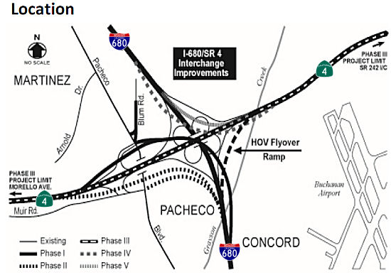 In April 2013, it was reported that there was finally a path ahead to
improving the interchange of I-680 and Route 4. This interchange is so
problematic that Contra Costa voters in 1988 approved a half-cent sales
tax to start planning its fix. Almost 25 years later, Contra Costa
County's congestion management agency says it has found a path to begin
the first phase of the $400 million freeway fix in about two years,
pulling it out of an indefinite limbo. Under earlier plans, the congestion
agency and Caltrans would have waited until the money was lined up to
build the most expensive yet effective parts of the five-phase project. To
break the logjam, the county agency revamped its construction staging and
financing plans. The agency plans to start smaller and have more money to
spend because of the improving economy. It would begin with widening three
miles of Route 4 to add an extra lane in each direction between Morello
Avenue and Route 242. The widening would cost some $50 million. The
transportation authority also figures it will have $186 million more than
previously expected over the next 21 years because of improvements in its
financial picture. The agency is taking in more sales tax revenues as the
economy recovers. The authority also got an "AA+" credit rating last fall
from two rating agencies, enabling it to save millions of dollars in
selling $225 million in bonds in December, and refinancing $200 million of
existing debt. With a rosier outlook ahead, the Transportation Authority
board on Wednesday is scheduled to authorize consultants to study design
on the highway widening. That action could lead to a widening contract
being awarded in 2015. In later phases of the freeway overhaul,
contractors will build new connector ramps, remove the cloverleaf
connectors, and add a flyover ramp so motorists can stay in a carpool lane
continuously while merging from one freeway to another. Getting started on
the project makes it easier to seek state and federal grants for later
phases of construction.
In April 2013, it was reported that there was finally a path ahead to
improving the interchange of I-680 and Route 4. This interchange is so
problematic that Contra Costa voters in 1988 approved a half-cent sales
tax to start planning its fix. Almost 25 years later, Contra Costa
County's congestion management agency says it has found a path to begin
the first phase of the $400 million freeway fix in about two years,
pulling it out of an indefinite limbo. Under earlier plans, the congestion
agency and Caltrans would have waited until the money was lined up to
build the most expensive yet effective parts of the five-phase project. To
break the logjam, the county agency revamped its construction staging and
financing plans. The agency plans to start smaller and have more money to
spend because of the improving economy. It would begin with widening three
miles of Route 4 to add an extra lane in each direction between Morello
Avenue and Route 242. The widening would cost some $50 million. The
transportation authority also figures it will have $186 million more than
previously expected over the next 21 years because of improvements in its
financial picture. The agency is taking in more sales tax revenues as the
economy recovers. The authority also got an "AA+" credit rating last fall
from two rating agencies, enabling it to save millions of dollars in
selling $225 million in bonds in December, and refinancing $200 million of
existing debt. With a rosier outlook ahead, the Transportation Authority
board on Wednesday is scheduled to authorize consultants to study design
on the highway widening. That action could lead to a widening contract
being awarded in 2015. In later phases of the freeway overhaul,
contractors will build new connector ramps, remove the cloverleaf
connectors, and add a flyover ramp so motorists can stay in a carpool lane
continuously while merging from one freeway to another. Getting started on
the project makes it easier to seek state and federal grants for later
phases of construction.
(Source: Contra Costa Times, 4/14/13)
In March 2015, the CTC received notice of a future STIP amendment from the Contra Costa Transportation Authority (CCTA), which proposed to delay $36,610,000 in Regional Improvement Program (RIP) construction funds from Fiscal Year (FY) 2015-16 to FY 2016-17 for the I-680/Route 4 Interchange – Phase 3 project (PPNO 0298E) in Contra Costa County. As of March 2015, the Phase 3 project was programmed with $36,610,000 in RIP construction in FY 2015-16. This Phase 3 project scope consists of widening Route 4 in the median to construct an additional lane in each direction from Morello Avenue to Route 242. The current scope of work also includes widening of various bridge structures within the project limits. Originally, the highway bridge structure spanning the Grayson Creek was planned to be widened. However, based upon a detailed analysis and evaluation of the condition of this aged structure, was determined that it is necessary to replace it. Furthermore, permits from the US Army Corp of Engineers will now be needed for both the Grayson Creek bridge replacement and the Walnut Creek bridge widening work. The CCTA is actively seeking additional funds to cover the cost of replacing the Grayson Creek Bridge. However, if additional funding does not materialize, the overall project cost will be reduced by adjusting the westbound projects limits. As a result of additional design efforts and the above described permit requirements, the delivery of the project will be delayed from Fiscal Year 2015-16 to 2016-17. In May 2015, the STIP amendment showed up on the CTC agenda and was approved.
In March 2016, it was reported that the MTC, in
response to state budget cuts, had tentatively cut the I-680/Route 4
project, putting off their funding until at least 2021. The project would
construct a new interchange where I-680 meets Route 4 in Contra Costa
County. The interchange would replace an outdated and overwhelmed
cloverleaf design that’s snarled with commuters forced to weave in
and out of traffic.
(Source: SF Gate, 3/10/2016)
In March 2017, the CTC amended the STIP to change the implementing agency on the right of way portion of the project. That amended provided the following additional innformation: On March 20, 2014, the Commission adopted the 2014 STIP, which included the I-680/ Route 4 Interchange – Phase 3 project. It consists of widening Route 4 by constructing an additional lane in each direction from Morello Avenue to Route 242. The project was programmed with $36,610,000 in Regional Improvement Program (RIP) funding for construction and the R/W phase was funded 100 percent with local funds. Then in September 2014, CCTA decided to have the Department take the lead in doing the R/W work and amended their cooperative agreement to reflect the change. On May 18, 2016, the Commission adopted the 2016 STIP, and due to funding shortfalls, CCTA was forced to delete STIP funding from existing projects. CCTA deleted $31,510,000 in STIP RIP funding for construction of the I-680/ Route 4 Interchange project and replaced it with local funds. The remaining $5,100,000 in STIP RIP funding for construction was reprogrammed to fund cost increases for R/W in FY 2017-18. The cost increases resulted from additional utility work that had not been previously identified. Currently, R/W is still programmed with CCTA as the implementing agency however, this amendment revises the implementing agency from CCTA to have the Department take the lead. This amendment also splits R/W into $4,800,000 Capital and $300,000 support and also updates the local funding in the funding plan.
The 2018 STIP, approved at the CTC March 2018 meeting, appears to adjust the funding for PPNO 0298E, Route 4/I-680 Interchange Phase 3, Widen Route 4 in the median to provide a third lane in each direction from Morello Avenue to Route 242 (PM R10.5/R15.1). This scope of work also includes widening/replacing/ various bridges within the project limits. The 2018 STIP restores $18,800K in funding for construction in FY19-20.
In May 2018, the CTC approved for future consideration
of funding the following project for which a Negative Declaration (ND) has
been completed: I-680 and Route 4 in Contra Costa County. Construct
interchange improvements on I-680 at Route 4 in Contra Costa County.
(0298E) (04-CC-680, PM 20.22/22.2, 04-CC-4, PM R10.5/15.1) This project is
located at the I-680/Route 4 interchange in Contra Costa County. The
project proposes to widen Route 4, widen five bridge structures and
replace the Grayson Creek Bridge. The existing I-680/Route 4 interchange
has deficiencies that contribute to traffic congestion and inefficient
traffic operations. The project proposes to reduce traffic congestion,
improve operation efficiency and accommodate existing and planned growth
in travel demand. This project is proposed to be implemented in five
phases for an estimated cost of $297.6 million. The project is not fully
funded and is currently programmed for $102.6 million in STIP, SHOPP,
Senate Bill (SB) 1 Local Partnership Program (LPP) and Local programs.
Construction for Phase 3 is estimated to begin in 2018. The scope, as
described for the preferred alternative, is consistent with the project
scope programmed by the Commission in the 2018 STIP.
(Source: CTC Agenda, May 2018 Agenda Item 2.2c(1))
In May 2018, it was reported that upgrades to the
I-680/Route 4 interchange in Pacheco, considered a bottleneck for traffic
in Contra Costa County, are closer to reality after the California
Transportation Commission approved $34 million in funding for
improvements. The funding, approved by the CTC at its May meeting, comes
about two and a half years after a group of politicians, union leaders and
transportation officials gathered in a parking lot near the interchange to
decry the proposed cut of more than $750 million from planned
transportation projects statewide.
(Source: SF Gate, 5/21/2018)
In June 2018, the CTC made the following allocation:
$20,500,000 Contra Costa 04-CC-4 12.9. PPNO 0298X. On Route 4 Near
Martinez, at Grayson Creek Bridge No. 28-0066 R/L. Outcome/Output:
Replace eastbound and westbound directional bridges.
(Source: CTC Agenda, June 2018 Agenda Item 2.5b(1) Item 16)
In July 2018, it was reported that utility location for
the interchange project was taking place. The project will build a
three-level interchange with two-lane ramps for the northbound to
westbound and eastbound to southbound movements. It will also widen Route 4 from four to six lanes, eliminate the current eastbound lane drop on
Highway 4 west of Pacheco Boulevard and construct auxiliary lanes to
adjacent interchange ramps at Morello Avenue and Solano Way on Route 4,
and Pacheco Boulevard and Concord Avenue on I-680.
(Source: Mercury News, 7/18/2018)
The project is being constructed in five phases:
Due to funding shortfalls, Phase 3 will be constructed
first. The remaining phases will be constructed as funding becomes
available. All phases were environmentally cleared in November 2008. Phase
3 environmental revalidation was completed in December 2015. Phase 3
design is complete as of July 2018, and Caltrans was preparing the bid
package to advertise the project for construction. Utility coordination
efforts with Kinder Morgan, Phillips 66, and Contra Costa Water District
(CCWD) were led by Caltrans, and relocation work begin in June 2018 and
was expected to finish in October 2018. Phase 3 construction bid
advertisement is planned for July 2018. Construction was expected to start
in Fall 2018.
(Source: CCTA Project Fact Sheet)
In January 2019, it was reported that work has begun to
widen a four-mile stretch of Route 4, a project that transportation
officials say will help reduce traffic and improve safety at its
intersection with I-680. The project will entail adding a third lane in
the east- and westbound directions between Morello Avenue in Martinez and
Route 242. It’s the first phase of a multi-phase project that will
eventually include lengthening the carpool lane on Route 4 by two miles,
installing safety lighting, widening highway structures and building ramp
connectors. The first phase, which will also include replacing the Grayson
Creek Bridge, is expected to be finished in 2021 and cost $136.2 million
— of which $77.7 million will come from SB1 funds that Assemblyman
Tim Grayson, D-Concord, worked to secure. Funding has not yet been
obtained for future phases of the project. In addition to widening Route 4, the project will raise the profile of the roadway slightly, allowing it
to be more “resilient.” More lighting and traffic striping is
intended to improve roadway visibility. And in addition to the Grayson
Creek Bridge, which will be replaced with a new three-span road bridge
structure, more widening and retrofit work will take place on the Walnut
Creek Bridge, Solano Way Undercrossing and Peralta Road Undercrossing.
(Source: East Bay Times, 1/25/2019)
In June 2019, it was reported that the Contra Costa
Transportation Authority (CCTA) and the California Department of
Transportation (Caltrans) are plugging away on the first phase of a
multi-phased project to improve safety and help reduce congestion. The
initial phase of construction involves widening a 4-mi. segment of Route 4
in both directions between Morello Avenue in Martinez and Route 242. The
work also involves the replacement of the Grayson Creek Bridge to bring it
up to current state bridge safety codes. Work began in November 2018 and
is scheduled for completion in late 2021 or early 2022. The project calls
for the addition of a third lane in the eastbound and westbound directions
to improve on-ramp and off-ramp merging. Along with the Grayson Creek
Bridge replacement, the project includes widening of four other bridges;
extending eastbound Route 4's carpool lane approximately 2 mi.; and
installation of safety lighting. More than 50 years old, the Grayson Creek
Bridge has exceeded its serviceable life. Currently the project is focused
on constructing the foundations for Grayson Creek Bridge and the four
other bridges to be widened. The entire project area extends about 4 mi.
along Route 4 and I-680. It crosses over three streets. The work is funded
by Measure J, a local transportation sales tax, state highway operation
and protection program, SB 1 and state transportation program dollars.
About 110,000 Yd3 of concrete will be used over the course of
the project. That does not include pre-cast or pre-fabricated concrete
brought on site including girders and pipe. About 42,000 tons of asphalt
will be placed as part of the project. The project lays the groundwork for
future improvements to connector ramps, improved traffic safety and
enhanced traffic flow. In addition to widening Route 4 in both directions,
the project will raise the roadway profile and widen the median and
outside shoulders at Grayson Creek. The project also will provide enhanced
lighting and traffic striping to improve roadway visibility during
nighttime hours.
(Source: Construction Equipment Guide, 6/4/2019)
In March 2020, the CTC approved the 2020 STIP, which
appeared to make no changes made in the amounts programmed for PPNO 0298E
Rt 680/4 interchange, widen Rt 4 (Ph3)(16S-03)(RW 1-19).
(Source: March 2020 CTC Agenda, Item 4.7, 2020 STIP
Adopted 3/25/2020)
In December 2020, it was reported that the CTC approved
$18 million for the final design of further improvements to the
I-680/Route 4 Interchange in Contra Costa County.
(Source: The Bay Link, 12/3/2020)
In May 2021, the CTC approved an allocation of
$18,000,000 for the locally-administered Senate Bill 1 (SB 1) Trade
Corridor Enhancement Program (TCEP) I-680/Route 4 Interchange Improvements
– Phases 1, 2 A project (PPNO 04-0298F; ProjID 0420000156; EA
22914), 04-CC-680 20.2/22.2; 04-CC-4 10.5/15.1). I-680/SR4
Interchange Improvements - Phases 1, 2 A. In Contra Costa
County near Concord and Martinez, Phase 1 will construct a two-lane
flyover direct connector from northbound I -680 to westbound Route 4 with
ramp metering, remove the existing northbound I-680 to westbound Route 4
loop ramp, construct auxiliary lanes on westbound Route 4 as well as
northbound I-680, and add a slip ramp from northbound I-680 to Pacheco
Blvd. Phase 2A would extend the southbound I -680 collector-distributor
ramp and install a ramp metering facility. PS&E $18,000,000. (Future
consideration of funding approved under Resolution E-18-37; May 2018.)
(Contribution from other sources: $8,000,000.)
(Source: May 2021 CTC Agenda, Agenda Item 2.5s.(5))
In July 2023, it was reported that in June 2023 MTC
last month formally approved the first allocations of Regional Measure 3
dollars, releasing over $270 million for nine projects for which the
sponsors already were moving ahead under Letters of No Prejudice. These
initial allocations included: Contra Costa Transportation Authority: $13
million for ongoing work to reconfigure the I-680/Route 4 interchange.
(Source: MTG/ABAG Bay Link Blog, 7/12/2023)
I-680 near Concord (~ 004 CC 12.723) to Route 160 near Antioch (~ 004 CC R30.513)
Constructed to freeway standards from 5 miles east of Route 80 (apx 004 CC R5.116) to Route 160 (apx 004 CC R30.513). Route 4 between I-80 and I-680 will be upgraded to an expressway with provisions included to upgrade it to freeway later. Also, the freeway portion of Route 4 is being extended to bypass Brentwood. There are plans under consideration to eventually build a freeway from Brentwood to Stockton roughly parallel to Route 4's current alignment. There are also plans to widen this route in Pittsburg (March 2001 CTC Agenda). Some original portions of the route (PM R15.3) in the City of Concord were up for relinquishment in December 2001. This may eventually connect to I-580.
 In February 2013, it was reported there are plans to energize metering lights along Route 4 in Pittsburg by 2015.
Caltrans is in the process of repairing the existing -- but never used --
traffic lights at Highway 4 entrances between Solano Way (004 CC R13.663)
and Railroad Avenue (apx 004 CC 23.066). Construction for that segment is
estimated at about $900,000, according to the Metropolitan Transportation
Commission. Plans call for lights to be added as part of the widening
project under way from Pittsburg's Loveridge Road to Hillcrest Avenue in
Antioch and ready to be activated once road construction is complete. The
price tag for those lights is estimated at about $26 million. Though
installed in 1995, Contra Costa transportation officials and local leaders
had balked at using metering lights because they could cause surface
street backups where onramps are short and red lights are long, thus
creating headaches for local traffic.
In February 2013, it was reported there are plans to energize metering lights along Route 4 in Pittsburg by 2015.
Caltrans is in the process of repairing the existing -- but never used --
traffic lights at Highway 4 entrances between Solano Way (004 CC R13.663)
and Railroad Avenue (apx 004 CC 23.066). Construction for that segment is
estimated at about $900,000, according to the Metropolitan Transportation
Commission. Plans call for lights to be added as part of the widening
project under way from Pittsburg's Loveridge Road to Hillcrest Avenue in
Antioch and ready to be activated once road construction is complete. The
price tag for those lights is estimated at about $26 million. Though
installed in 1995, Contra Costa transportation officials and local leaders
had balked at using metering lights because they could cause surface
street backups where onramps are short and red lights are long, thus
creating headaches for local traffic.
(Source: Contra Costa Times, 2/27/13)
In August 2021, it was reported that construction crews have begun the
demolition of the westbound loop offramp from state Route 4 to Bailey Road
in Bay Point (~ CC R20.076), part of the Bailey Road/Route 4 Interchange
Pedestrian and Bicycle Improvement Project, according to the Contra Costa
County Public Works Department. To prepare for the demolition, the offramp
was permanently closed and traffic permanently redirected to the Route 4
westbound diagonal offramp, which has been widened and now can accommodate
both northbound and southbound traffic onto Bailey Road. The project is
expected to be completed sometime in October 2021.
(Source: Local News Matters, 8/24/2021)
In June 2012, the CTC authorized relinquishment of right of way in the city of Pittsburg along Route 4 on Railroad Avenue, consisting of a collateral facility. (apx 004 CC 23.066)
In June 2019, the CTC authorized relinquishment of right of way in the
city of Antioch (City) along Route 4 at Century Boulevard (04-CC-4-PM
25.0), consisting of a reconstructed city road. The City by freeway
agreement dated May 24, 2011, agreed to accept the relinquishment and by
letter signed February 5, 2019, agreed to waive the 90-day notice
requirement and accept title upon relinquishment by the State.
(Source: June 2019 CTC Minutes, Agenda Item 2.3c)
In July 2016, it was reported that only two months after the Pittsburg
police chief drafted a report asking for $100,000 to buy cameras trained
on Route 4 to help prevent, investigate and prosecute freeway shootings
that have plagued the East Bay in recent months, 14 cameras have been
installed. Police Capt. Ron Raman expects them all to be activated in
mid-July. Not only did the city council move fast in May to approve the
spending, but Caltrans approved in six weeks an "encroachment permit"
allowing cameras on state highway property. The original plan had been to
place the cameras on nearby city or private property that wouldn't have
afforded such thorough coverage. The new cameras will cover every inch of
Route 4 within the Pittsburg city limits. The cameras will be integrated
into the city's existing system monitoring via video every section of the
city. The first of those cameras was activated in 2005, and the city now
has more than 120 of them blanketing the city.
(Source: East Bay Times, 7/18/2016)
Route 4 / Brentwood / Antioch Widening (General)
The SAFETEA-LU act, enacted in August 2005 as the reauthorization of TEA-21, provided the following expenditures on or near this route:
In his 2006 Strategic Growth Plan, Governor Schwartzenegger proposed widening the route in Contra Costa County. In 2007, the CTC recommended using $85M from the Corridor Mobility Improvement Account (CMIA) to fund widening the route from Somersville (004 CC 26.002) to Route 160 (apx 004 CC R30.513)
Route 4 East Widening
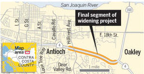
TCRP Project #16 involved widening to six or more lanes from east of Loveridge Road (apx 004 CC 24.358) through Hillcrest (apx 004 CC R28.97). The project was requested by the Contra Costa Transportation Authority. In June 2006, a negative environmental impact (a good thing) was received by the CTC for subproject #16.2. This project would widen Route 4 from about 1 mile west of Loveridge Road to about 1 mile east of Hillcrest Avenue interchange near Route 160. The proposed project would widen Route 4 from 4-lanes to 8-lanes, with two of the lanes being used for high occupancy vehicle lanes. The improvements would conform with the improvements being made on Route 4 to the west of Loveridge Road, as well as planned improvements to the east of Hillcrest Avenue interchange. There are also plans (TCRP #16.4) to widen the freeway to eight lanes from Railroad through Loveridge Road in Contra Costa County. (June 2002 CTC Agenda Item 2.1c.(2)).
There are actually two projects here. The Route 4 East Widening from Loveridge Road to Somersville Road project is located in Contra Costa County. The CMIA project will: (1) Widen Route 4 to eight lanes by constructing three mixed-flow lanes and one High Occupancy Vehicle (HOV) lane in each direction from Loveridge Road to Somersville Road; and (2) Reconstruct Loveridge Road Interchange. The Route 4 East Widening from Somersville to Route 160 project is located adjacent to the above described project in Contra Costa County. This project will: (1) Widen Route 4 to eight lanes (three mixed flow lanes and one HOV lane in each direction), construct auxiliary lanes and a wide median for transit from Somersville Road to Hillcrest Avenue; (2) Widen Route 4 to six lanes (three mixed flow lanes in each direction) from Hillcrest Avenue to the interchange with the Route 160/Route 4 Bypass; (3) Reconstruct Somersville Road, Contra Loma, and L Street interchanges, and G Street Overcrossing; and (4) Modify Lone Tree Way/A Street and Hillcrest Avenue interchanges and Cavallo Road Undercrossing. Construction began on segment (1) in August 2010.
In November 2007, there was an update on Project #16.2. On April 19, 2007, the Union Pacific Rail Road (UPRR) rejected the San Francisco Bay Area Rapid Transit District (BART) and CCTA’s final and best offer to acquire the Moccoco line where a future BART extension would have transitioned out of the Route 4 median at Loveridge Road interchange onto the Moccoco line located to the north of Route 4. As a result of the UPRR rejection, the alignment of the future BART extension has been revised to go inside the Route 4 (east) median where it will run through the Loveridge Road and Somersville Road interchanges. With the new BART alignment, right-of-way and utility costs on TCRP Project #16.2 have increased. Additional right of way is needed to accommodate the future BART extension that requires an additional 20 to 22 foot median. This change also triggered the relocation of two additional Pacific Gas & Electric (PG&E) high voltage transmission towers and also the relocation of an additional length of a 24 inch gas line. As a result, the Contra Costa Transit Agency requested the $14 million in TCRP funds originally programmed for construction to be redistributed to cover additional right-of-way clearance activities. In addition to right-ofway increases, material and construction costs have increased since the original cost estimate was developed due to the replacement of the Century Boulevard undercrossing, as well as another minor structure, which is now being incorporated into this project. Additional funding from State Transportation Improvement Program (STIP), Federal SAFETEA-LU and local Measure C and Regional Measure 2 funds have been secured to cover the project cost increase. The project funding plan has been updated to reflect the cost increase to both R/W and Construction. The project schedule was updated to reflect the delays caused by the redesign of new BART alignment.
In September 2009, the CTC approved an exchange of funds on this project.
![[Project Map]](maps/004-antioch.jpg) In February 2010, the CTC approved for future
consideration of funding a project that will construct roadway
improvements to a section of Route 4 from Loveridge Road near Pittsburg
(apx 004 CC 24.343) east to Route 160. The improvements will include two
additional lanes in each direction, interchange reconstructions to
accommodate the roadway widening, and various other safety improvements.
The project is programmed in the Corridor Mobility Improvement Account and
the 2008 State Transportation Improvement Program, and includes local
funds. The total estimated project cost is $446,739,000 for capital and
support. Construction of Segment 1 is estimated to begin in Fiscal Year
2010-11. The scope as described for the preferred alternative is
consistent with the project scope set forth in the proposed project
baseline amendment. A Negative Environment Impact Declaration was
prepared, as the project will involve construction activities resulting in
visual effects that will be addressed by aesthetic treatments. The project
also involves the acquisition of new right-of-way.
In February 2010, the CTC approved for future
consideration of funding a project that will construct roadway
improvements to a section of Route 4 from Loveridge Road near Pittsburg
(apx 004 CC 24.343) east to Route 160. The improvements will include two
additional lanes in each direction, interchange reconstructions to
accommodate the roadway widening, and various other safety improvements.
The project is programmed in the Corridor Mobility Improvement Account and
the 2008 State Transportation Improvement Program, and includes local
funds. The total estimated project cost is $446,739,000 for capital and
support. Construction of Segment 1 is estimated to begin in Fiscal Year
2010-11. The scope as described for the preferred alternative is
consistent with the project scope set forth in the proposed project
baseline amendment. A Negative Environment Impact Declaration was
prepared, as the project will involve construction activities resulting in
visual effects that will be addressed by aesthetic treatments. The project
also involves the acquisition of new right-of-way.
In October 2010, there was an update on Segment 1 (PPNO 0192F). Walnut Creek-based R&L Brosamer Inc. was reported to be in line to get the contract for building the next segment of widening -- from just west of Somersville Road to just west of Contra Loma Boulevard -- after a bid of $35.7 million. The bid was significantly lower than the anticipated cost of $49.7 million. The Somersville-to-Contra Loma segment is expected to break ground in January. Work on that stretch includes adding four lanes, along with a new offramp configuration at Somersville. Upon completion of the entire project, the highway will have eight lanes -- three regular lanes and a carpool lane in each direction -- from Loveridge Road in Pittsburg east to the Route 4 bypass interchange. Widening work is in progress from Loveridge to Somersville. Berkeley-based O.C. Jones & Sons was awarded the contract for the Loveridge-to-Somersville segment in February after a bid of $64.9 million, far lower than the anticipated cost of $91 million. The Loveridge-to-Somersville stretch is expected to be done by 2014. The next segment of the Route 4 widening, from Contra Loma to Lone Tree Way, is expected to go out to bid in Summer 2011. Plans have been designed and funding is in place for that stretch. The entire widening is expected to be completed by 2015, with an estimated total cost of more than $500 million. The expansion includes creating a highway median wide enough to accommodate BART's extension into East County.
In February 2010, the CTC also approved a concurrent baseline amendment request (Resolution CMIA-PA-0910-019) to increase the project scope and split the overall project into three roadway contracts and one follow-up landscape contract. This noted that the project will widen Route 4 East to eight lanes (three mixed flow lanes and one high occupancy vehicle [HOV] lane in each direction) from Somersville Road to Hillcrest Avenue; add auxiliary lanes and construct a wide median for transit from Somersville Road to Hillcrest Avenue; widen Route 4 to six lanes (three mixed flow lanes in each direction) from Hillcrest Avenue to the interchange with Route 160/Route 4 bypass; reconstruct Somersville Road Interchange and Contra Loma/L Street Interchange, and replace G Street Overcrossing and Cavallo Road Undercrossing; and partially reconstruct Lone Tree Way/A Street and Hillcrest Avenue Overcrossings. The project will also construct a wide median to accommodate the e-BART project; e-BART is a 10-mile extension of the current mass transit system in Eastern Contra Costa County that will run in the median of Route 4, extending passenger rail service from the Pittsburg/Bay Point BART Station to the vicinity of Hillcrest Avenue in the city of Antioch. The project is also being split into four segments: Segment 1 (PPNO 0192F): Widen Route 4 from Somersville Road to Contra Loma/L Street and reconstruct Somersville Road Interchange, including construction of an e-BART structure at Somersville Road, along with the construction of underground drainage, underground electrical work and sub-ballast within the contract limits; Segment 2 (PPNO 0192H): Widen Route 4 from Contra Loma Boulevard/L Street to Lone Tree Way/A Street, reconstruct Contra Loma Boulevard/L Street Interchange, and replace G Street Overcrossing, including construction of an e-BART structure at Contra Loma Boulevard/L Street, along with the construction of underground drainage, conduits for underground electrical work and sub-ballast within the contract limits; Segment 3 (PPNO 0192I): Widen Route 4 from Lone Tree Way/A Street to Route 160 and partially reconstruct Lone Tree Way/A Street Interchange, replace Cavallo Road Undercrossing, and partially reconstruct Hillcrest Avenue Interchange, including construction of e-BART structures at A Street/Lone Tree Way and Cavallo Road, along with the construction of underground drainage, conduits for underground electrical work and sub-ballast within the contract limits; Segment 4 (PPNO 0192J): Construct follow-up landscaping on Route 4 from Somersville Road to Route 160 Interchange in Contra Costa County.
In June 2011, the CTC amended this project to update the project scope of the Segment 3 project by: (a) shortening the westbound high occupancy vehicle (HOV) lane by about 0.8 mile, (b) adding a westbound auxiliary lane between Hillcrest Avenue and Route 160, and (c) replacing the Roosevelt Pedestrian Undercrossing. They also split the Segment 3 project into two sub-segments, Segment 3A and Segment 3B.
In September 2011, it was reported that thanks to a low bid for a segment of the Route 4 widening in Antioch, a project in Brentwood could receive money to start construction. Rancho Cordova-based CC Myers, Inc. is expected to get the contract for building the next segment of widening -- from just west of Contra Loma Boulevard to near G Street -- after a bid of about $48.8 million. The bid represents a savings of more than $9 million from the anticipated cost.
In February 2012 (bids opened April 2012), a contract was put out to bid by Caltrans to widen Route 4 to 8 lanes, reconstruct the A St. undercrossing, and construct retaining and sound walls in Antioch from the G Street Overcrossing to 0.1 Mile East of the Hillcrest Avenue Overcrossing.
In March 2012, it was reported that the G Street offramp from Route 4 in Antioch would close permanently as part of the project that is expanding the freeway from a little less than a mile west of Loveridge Road to about three-quarters of a mile west of Hillcrest Avenue. The project removing the on- and offramps at G Street involves constructing a new, wider G Street bridge for local traffic. Combined with a full-service interchange at Contra Loma Boulevard to be completed in spring 2015, these changes will provide better access to the highway and improve local traffic circulation.
In August 2012, the CTC approved amending the Route 4 East Widening Corridor project. The funding source was changed -- specifically, CCTA proposed swapping $5,868,000 of those local funds with State-Local Partnership Program (SLPP) funds. Additionally, the project schedule was updated to reflect delays resulting from the revision of construction staging plans due to additional construction conflicts with the adjacent Hillcrest Station Parking Lot and Maintenance Shell project being implemented by the BART. Furthermore, the construction duration has been increased by eight months to fully address the construction conflicts with Segment 3A, which was awarded in May 2012. The project is now scheduled to end construction in August 2015.
 In November 2012, it was
reported that bids on the Route 4 widening project came in lower than
expected, with the Rancho Cordova-based Bay Cities/Myers in line to get
the contract following a bid of $48.67 million -- about $7 million less
than the anticipated price tag of $55.7 million. The low construction bid
for the Hillcrest project means that each of the five segments awarded for
the Route 4 widening over the last two years has yielded millions in cost
savings. About $75 million has been saved on the project because of the
low bids. Construction should begin in January 2012. The work will include
adding lanes from just east of Hillcrest Avenue to the Route 160
interchange, along with a on- and offramps at Hillcrest. It will also
include several components of BART's station east of Hillcrest, including
a pedestrian overcrossing, station platform and station house and a tunnel
underneath the westbound lanes so trains can get into their maintenance
station.
In November 2012, it was
reported that bids on the Route 4 widening project came in lower than
expected, with the Rancho Cordova-based Bay Cities/Myers in line to get
the contract following a bid of $48.67 million -- about $7 million less
than the anticipated price tag of $55.7 million. The low construction bid
for the Hillcrest project means that each of the five segments awarded for
the Route 4 widening over the last two years has yielded millions in cost
savings. About $75 million has been saved on the project because of the
low bids. Construction should begin in January 2012. The work will include
adding lanes from just east of Hillcrest Avenue to the Route 160
interchange, along with a on- and offramps at Hillcrest. It will also
include several components of BART's station east of Hillcrest, including
a pedestrian overcrossing, station platform and station house and a tunnel
underneath the westbound lanes so trains can get into their maintenance
station.
(Source: Contra Costa Times, 11/1/2012)
In September 2015, it was reported that completion of
the Route 4 widening project has been delayed. The updated estimate is
that the Route 4 widening project should be finished by midsummer of 2016,
an extension of at least six to eight months beyond the agency's original
estimate that the project would be completed by the end of 2015.
Construction supervisors say East Contra Costa's notorious heat, coupled
with high winds in the area, have forced workers to postpone concrete
pours time and time again, delaying the project. However, a segment of the
project expected to ease traffic flow in both directions should be
completed by early October 2015. That segment will add two westbound lanes
around the A Street exit, and an additional lane eastbound near A Street,
along with similar improvements around Somersville Road and Loveridge Road
exits, which officials say will push the Route 4 bottleneck farther east.
Construction on the $1.3 billion highway-widening project began in 2011,
and by completion will have required 13.8 million pounds of steel, and
nearly 8 million cubic feet of concrete. If that concrete isn't poured
under the right weather conditions, it is subject to cracking. Cracked
concrete will inevitably allow water to trickle in, leading to rusted
rebar, bigger cracks and deeply seeded damage that can only be fixed by
tearing up that section of roadway and repaving it.
(Source: Contra Costa Times, 9/11/2015)
In February 2016, it was reported that a pair of ramps,
one connecting westbound Route 4 to Route 160 leading to the bridge and
the other connecting southbound Route 160 to eastbound Route 4, were
opened in late February. The ramps will eliminate the need for motorists
heading to and from eastern Contra Costa to the bridge to drive about a
mile farther west to make U-turns at the Hillcrest Avenue interchange in
Antioch. The connector ramps project is also adding new lanes in both
directions on Route 160 from the Route 160/Route 4 interchange north to
the interchange at East 18th and Main streets. The expansion of the Route 160/Route 4 interchange will allow room for the BART extension in the
median of Route 4. The project, which includes new sound wall extensions
and new retaining walls, was funded by $50 million from the Bay Area Toll
Authority. The ramps are a part of the larger $1.3 billion project led by
the CCTA and other agencies to widen Route 4 between Pittsburg and Antioch
from two lanes in each direction to four lanes beginning at Loveridge Road
and extend BART along the corridor from the Pittsburg/Bay Point station to
Antioch.
(Source: East Bay Times,2/29/2016)
In July 2016, it was reported that a community
celebration and ribbon cutting marked the completion of the Route 4
Widening Projects, a six-year-long collaborative endeavor by the Contra
Costa Transportation Authority (CCTA), the California Department of
Transportation (Caltrans), Bay Area Rapid Transit (BART), the Metropolitan
Transportation Commission, the California Transportation Commission and
the Federal Highway Administration. The Route 4 Widening Projects include
improvements that expand Route 4 from four to eight lanes between
Loveridge Road in Pittsburg to just west of Route 160 in Antioch and from
two to four lanes from Lone Tree Way to Balfour Road in Brentwood. The
projects also added missing connector ramps at the Route 160/Route 4
interchange and will add a BART extension from Pittsburg to Antioch. CCTA
funded more than a quarter of the project ($362 million) through Measure
J, a half-cent sales tax reauthorized by Contra Costa voters in 2004, and
through the previous Measure C. With the exception of just one structure,
the entire highway facility between Pittsburg and Brentwood was
reconstructed, including 21 bridges. These projects were built to last
using the latest materials, including asphalt concrete (the total weight
of asphalt placed is over 228,000 tons). In addition to bringing 12,775
high-paying construction jobs to the region, the projects have laid the
infrastructure for potential permanent employment centers along East
County’s northern waterfront.
(Source: East County Today, 7/21/2016)
In May 2018, the CTC authorized relinquishment of right
of way in the city of Pittsburg (City) along Route 4 on Loveridge Road,
consisting of collateral facilities (04-CC-4-PM 24.3/24.4, 3 Segments).
The City, by letter signed March 2, 2018, agreed to waive the 90-day
notice requirement and accept title upon relinquishment by the State.
(Source: CTC Minutes, May 2018 Agenda Item 2.3c)
In August 2020, the CTC authorized relinquishment of
right of way, consisting of collateral facilities, in the City of Antioch
along Route 4 on Somersville Road (04-CC-4-PM 26.0), right of way,
consisting of collateral facilities, in the City of Antioch along Route 4
on A Street and Lone Tree Way (04-CC-4-PM R27.8), and right of way,
consisting of collateral facilities, in the City of Antioch along Route 4
on Hillcrest Avenue (04-CC-4-PM R28.9), under the terms and conditions as
stated in the Freeway Agreement dated May 24, 2011. The City, by
resolution letter signed May 29, 2020, agreed to waive the 90-day notice
requirement and accept title upon relinquishment by the State.
(Source: August 2020 CTC Agenda, Agenda Item 2.3c)
In May 2021, the CTC authorized relinquishment of right
of way, consisting of collateral facilities in the city of Antioch along
Route 4 on G Street (04-CC-4-PM 27.3, 2 segments), under the terms and
conditions as stated in the freeway agreement dated May 24, 2011. Per the
relinquishment map, these appear to be two small collateral facilities on
either side of Route 4 where G Street meets Route 4. The City, by
Resolution No. 2011/37 dated May 24, 2011, agreed to accept title upon
relinquishment by the State and by letter dated November 20, 2020, agreed
to waive the 90-day notice requirement.
(Source: May 2021 CTC Agenda, Agenda Item 2.3c)
![[160/4 interchange]](images/004-bypass.jpg) According to James Bradley, as
of August 2004, the Route 4 Bypass Authority has approved and begun
construction on the new Route 4 Bypass, to be completed in THREE segments.
Segment TWO was completed in 2002 and is open for traffic as a two lane
roadway. It runs from Lone Tree Way (004 CC R32.999) at the
Antioch/Brentwood border to Balfour Road in Brentwood (004 CC R35.61).
Segment ONE began construction in 2004, and was completed in February
2008. It runs from the current Route 4/Route 160 junction (004 CC R30.521)
in Antioch to the completed portion at Lone Tree Way (004 CC R32.999).
Segment THREE began construction in the Spring of 2005, and was completed
in late 2008. It runs from the ending of Segment TWO at Balfour Road in
Brentwood, along Concord Ave, and will terminate at Vasco Road (future
Route 84). A connecting road between the new bypass and the current Route 4 (Marsh Creek Road) will be widened and upgraded to highway status. There
will be several new interchanges constructed. The interchanges will be as
follows: Route 4/Route 160 in Antioch (a picture of this interchange has
been provided by Carl Rodgers), Laurel Road/Slatten Ranch Road in Oakley,
Lone Tree Way in Antioch/Brentwood, Sand Creek Road in Brentwood, Balfour
Road in Brentwood, Marsh Creek Road in Brentwood, and Vasco Road/Walnut
Blvd./Route 84. Another update is in the Pittsburg area. Construction is
underway in Pittsburg for the Route 4 widening project from Baily Road to
Loveridge Road. The highway is being widened from 4 to 8 lanes, including
a BART extension to Railroad Ave. Some of the new exit signing (with exit
numbers) has already been erected at Railroad Ave. The new overpass at
Harbor Ave. is now open to traffic. As of February 2008, segment THREE had
grading completed from the end of Segment TWO at Balfour Road to Marsh
Creek Road. The new roadway is paved from Marsh Creek Road to Vasco Road,
but not yet striped. Traffic signals have been installed at the
intersections of Marsh Creek Road at Route 4 Bypass/Vasco Road, and Marsh
Creek Road at Walnut Blvd. The UPRR crossing of Marsh Creek Road has been
widened and new signals installed. Marsh Creek Road has been widened and
paved from the new Bypass Road/Vasco Road intersection to Sellers Ave.
Grading has started where Marsh Creek Road intersects with the current
Route 4, and Marsh Creek Road is currently being widened from Sellers
Avenue to Route 4. Also in February 2008, segment TWO of the bypass had
undergone construction to lower the intersection with Sand Creek Road by
several feet. This was done to accomodate the overpasses that will be
built when Segment TWO is widened to four lanes in 2009-2010. The Sand
Creek Road and Balfour Road interchanges will be built at that time. As of
April 2008, all of the Route 4 signs that had been installed on the bypass
have been removed. All street signs now simply say "Bypass Road". Also,
traffic signals have been installed at the intersection of the Bypass Road
& Vasco Road/Walnut Blvd. The new intersection has been graded, but
not yet paved. Segment 3 is now entirely paved, with the exception of
where it ties into Segment 2 at Balfour, and where it ties into Vasco
Road. All work on Marsh Creek Road appears to have ceased, as there has
not been any work done in several months.
According to James Bradley, as
of August 2004, the Route 4 Bypass Authority has approved and begun
construction on the new Route 4 Bypass, to be completed in THREE segments.
Segment TWO was completed in 2002 and is open for traffic as a two lane
roadway. It runs from Lone Tree Way (004 CC R32.999) at the
Antioch/Brentwood border to Balfour Road in Brentwood (004 CC R35.61).
Segment ONE began construction in 2004, and was completed in February
2008. It runs from the current Route 4/Route 160 junction (004 CC R30.521)
in Antioch to the completed portion at Lone Tree Way (004 CC R32.999).
Segment THREE began construction in the Spring of 2005, and was completed
in late 2008. It runs from the ending of Segment TWO at Balfour Road in
Brentwood, along Concord Ave, and will terminate at Vasco Road (future
Route 84). A connecting road between the new bypass and the current Route 4 (Marsh Creek Road) will be widened and upgraded to highway status. There
will be several new interchanges constructed. The interchanges will be as
follows: Route 4/Route 160 in Antioch (a picture of this interchange has
been provided by Carl Rodgers), Laurel Road/Slatten Ranch Road in Oakley,
Lone Tree Way in Antioch/Brentwood, Sand Creek Road in Brentwood, Balfour
Road in Brentwood, Marsh Creek Road in Brentwood, and Vasco Road/Walnut
Blvd./Route 84. Another update is in the Pittsburg area. Construction is
underway in Pittsburg for the Route 4 widening project from Baily Road to
Loveridge Road. The highway is being widened from 4 to 8 lanes, including
a BART extension to Railroad Ave. Some of the new exit signing (with exit
numbers) has already been erected at Railroad Ave. The new overpass at
Harbor Ave. is now open to traffic. As of February 2008, segment THREE had
grading completed from the end of Segment TWO at Balfour Road to Marsh
Creek Road. The new roadway is paved from Marsh Creek Road to Vasco Road,
but not yet striped. Traffic signals have been installed at the
intersections of Marsh Creek Road at Route 4 Bypass/Vasco Road, and Marsh
Creek Road at Walnut Blvd. The UPRR crossing of Marsh Creek Road has been
widened and new signals installed. Marsh Creek Road has been widened and
paved from the new Bypass Road/Vasco Road intersection to Sellers Ave.
Grading has started where Marsh Creek Road intersects with the current
Route 4, and Marsh Creek Road is currently being widened from Sellers
Avenue to Route 4. Also in February 2008, segment TWO of the bypass had
undergone construction to lower the intersection with Sand Creek Road by
several feet. This was done to accomodate the overpasses that will be
built when Segment TWO is widened to four lanes in 2009-2010. The Sand
Creek Road and Balfour Road interchanges will be built at that time. As of
April 2008, all of the Route 4 signs that had been installed on the bypass
have been removed. All street signs now simply say "Bypass Road". Also,
traffic signals have been installed at the intersection of the Bypass Road
& Vasco Road/Walnut Blvd. The new intersection has been graded, but
not yet paved. Segment 3 is now entirely paved, with the exception of
where it ties into Segment 2 at Balfour, and where it ties into Vasco
Road. All work on Marsh Creek Road appears to have ceased, as there has
not been any work done in several months.
In connection with this, Route 4 through Oakley (Route 160 to Delta Road) has been named "Main Street" by the City of Oakley, and "Brentwood Blvd" through Brentwood (Delta Road to Sellers Avenue) by the City of Brentwood. This is in anticipation of the highway relinquishment when the new bypass opens. In February 2012, it was reported that the Cities of Oakley and Brentwood officially took control of the former Route 4 from Route 160/Main Street interchange to the intersection of Byron Highway and Marsh Creek Road, and the state officially renamed the Bypass as Route 4. In January 2012, the CTC approved the following relinquishments: (1) right of way in the county of Contra Costa on Route 4 between the city limits of Oakley and Brentwood and from the Brentwood city limits to Marsh Creek Road, consisting of superseded highway right of way; (2) right of way in the city of Brentwood on Route 4 from State Route 160 to the south city limits at Delta Road, consisting of superseded highway right of way; and (3) right of way in the city of Oakley on Route 4 from the north city limits near Delta Road to the south city limits at the ECCID Main Canal, consisting of superseded highway right of way. They also approved transferring the Route 4 designation to the bypass route and adopted it as a freeway.
Route 4 Bypass Road
 There are also plans to add a road connection for a Route 4 Bypass Road. This connection
will relieve local traffic congestion and support planned development and
growth in the area. The Bypass Road is being constructed in three
segments. The northernmost segment, which includes the Route 4/ Bypass
Road interchange, opened to traffic in February 2008. At the completion of
the remaining segments, it is proposed that the Bypass Road be adopted as
Route 4 and existing Route 4 be relinquished to the local agencies.
However, as of the time of opening, "Bypass Road" was not yet officially
Route 4, it has been signed as Highway 4 from the Lone Tree Way onramp to
the interchange with NB Route 160. Some of the "Freeway Entrance" signs
say Route 4 West, and others simply say "Bypass Road".
There are also plans to add a road connection for a Route 4 Bypass Road. This connection
will relieve local traffic congestion and support planned development and
growth in the area. The Bypass Road is being constructed in three
segments. The northernmost segment, which includes the Route 4/ Bypass
Road interchange, opened to traffic in February 2008. At the completion of
the remaining segments, it is proposed that the Bypass Road be adopted as
Route 4 and existing Route 4 be relinquished to the local agencies.
However, as of the time of opening, "Bypass Road" was not yet officially
Route 4, it has been signed as Highway 4 from the Lone Tree Way onramp to
the interchange with NB Route 160. Some of the "Freeway Entrance" signs
say Route 4 West, and others simply say "Bypass Road".
Bypass Road diverges from Route 4 at the proposed new connection interchange in Antioch and reconnects to Route 4 at its intersection with Marsh Creek Road, a distance of 12.5 miles. Bypass Road is an access-controlled six- and four-lane freeway to just north of the Lone Tree Way interchange and continues as a two-lane expressway with limited access control to the intersection of the Bypass Road and Marsh Creek Road. The transfer will consist of relinquishment of a portion of existing Route 4 to the Cities of Oakley and Brentwood and Contra Costa County and adoption of the Bypass Road as the new Route 4 by the Department. The proposed new connection is a partial freeway-to-freeway interchange. This interchange will be located on a curve where Route 4 changes direction from west-east to south-north. The six-lane Bypass Road will extend to the east of the interchange as connector ramps will continue to Route 4/Route 160 junction to the north. Existing Route 4 is two-lanes in each direction and it will transition to three-lanes in each direction prior to the proposed connection to the Bypass Road. Connector ramps will be two-lanes wide for most of their length and will narrow to single lanes as they either exit or enter Route 4 at the proposed interchange.
Route 4 Bypass Freeway - Laurel to Sand Creek
In July 2011, it was reported that $25 million in
funding was secured from the CTC for converting a two-lane, two-way
section of the highway into a four-lane freeway. The project would
radically alter a stretch from north of Laurel Road to south of San Jose
Avenue, as well as the construction of an interchange at the bypass and
Sand Creek Road. The bypass would skirt the western edges of Oakley and
Brentwood, then rejoin Route 4 in an unincorporated area east of Discovery
Bay. The bypass will remove existing Route 4 from passing through the
downtown areas of Oakley and Brentwood. If the bid is awarded, the savings
likely will fill the funding gap for a Route 4 bypass interchange at Sand
Creek Road. The Sand Creek project would add onramps and offramps at Sand
Creek and widen the bypass to four lanes from Laurel Road in Oakley to the
interchange. The project, expected to cost $33 million, received $25
million in state bond funds in June. At that time, local officials also
received assurances from the California Transportation Commission that any
cost savings for the Route 4 widening would go toward other regional
projects. The new interchange will allow commuters to continue
uninterrupted instead of having to stop at the signal light at Sand Creek.
Southbound traffic often backs up during peak evening hours because of the
red lights beyond Lone Tree Way. If the Route 4 widening bid is approved,
the next step would be to make sure money is in place to start
construction. The county transportation authority either would wait for
the state to sell transportation bonds in spring 2012 or look at using
local funds to cover expenses until the sale. Construction on Sand Creek
could start as early as May or June 2012. The widening project includes a
full interchange at Contra Loma. The configuration now has only a
westbound onramp and eastbound offramp. G Street no longer will have an
onramp or offramp once the widening is complete.
(Source: Mercury News, 9/19/2011)
In December 2011, the CTC approved adding the Route 4 Bypass Freeway Conversion to the scope of the Route 4 East Widening Corridor project. The Route 4 Bypass Freeway Conversion Project — Phase 1 and 2 (Laurel Road (004 CC R31.367) to Sand Creek Road (004 CC R34.284), including Sand Creek Road Interchange) will convert a two-lane, two-way expressway to a 4-lane freeway from north of Laurel Road to south of San Jose Avenue and will construct an interchange at the intersection of the Route 4 Bypass and Sand Creek Road. The Route 4 Bypass will become the new alignment for Route 4 in eastern Contra Costa County. Once completed, this new segment will improve mobility by removing a significant bottleneck on the Route 4 Bypass. In addition, the project will also improve safety by converting a 2-lane expressway to a 4-lane freeway and constructing an interchange at Sand Creek Road. Estimated completion is in 2014.
In January 2012, the CTC approved $33 million to convert 3.2 miles of the Route 4 bypass from a two-lane expressway into a four-lane freeway from Sand Creek Road to Laurel Road in Antioch and Brentwood. They also allocated $52.7 million to widen an additional 1.7 miles of Route 4 from four to six lanes between Lone Tree Way and Hillcrest Avenue in Antioch. The rest of the $70 million project's cost comes primarily from regional bridge toll money and the Measure J sales tax approved by Contra Costa voters. The bypass contract is expected to be awarded in the spring, with the work taking about two years to complete.
In July 2022, it was reported that a long-awaited
arterial road has opened in Antioch. For almost 15 years, drivers in
Oakley could easily hop onto the Route 4 bypass from Laurel Road, but
those across the way in Antioch faced a dead-end, with the freeway in
sight within hundreds of yards but not accessible without a 1.5-mile
detour. The Laurel Road extension and interchange are expected to ease
congestion on the highway and help alleviate existing traffic delays
during commuter hours at other Route 4 bypass connections. It will also
provide faster access to the highway and connect Laurel Road to Oakley on
the other side of the Route 4 bypass. Envisioned decades ago, the Laurel
Road extension was delayed with changes in home developers. The first
developer obligated to extend the road when it began building houses north
of Laurel Road, Hertel Development, went bankrupt before a foundation was
ever laid. Davidon Homes is now building two Park Ridge communities with
512 houses nearby on 170 acres off Canada Valley and Laurel Road to the
south, while KB Home is building the 180-home Ranch subdivision to the
north of the road. The developers fully paid for the $10 million road
extension project. Two new intersections are included on this segment: a
full-access signalized intersection at Country Hills Drive, and another
above the bypass to the east that provides access for westbound
vehicles. Drivers can also enter the highway going east, a connection that
was built earlier. In addition, Laurel Road now connects to Country Hills
Road, which wraps around the southern and eastern edges of the new Park
Ridge subdivision.
(Source: East Bay Times, 7/20/2022)
In July 2012, it was reported that the new sound walls in Antioch have
been embossed with designs of the Delta marshlands. These new walls are at
the Somersville Road exit and along Route 4 near the Contra Loma Boulevard
exit. Plans call for the specialty retaining walls to be installed along
the entire stretch through Antioch, including the new eBART station near
Hillcrest Avenue. Transportation officials sought input from Antioch's
design review committee and Caltrans years ago, leading to the Delta
theme. Barb McKee of Denver-based Surface Strategy was hired to create the
wall scene. The process took about five years, including a year to carve
out the designs. Photos of the Delta landscape taken by McKee were used to
create large rubber molds. There are 10 8-by-12-foot patterns, or molds,
of the Delta walls and one "extender," or water pattern, for when walls
are different sizes or heights. Among the patterns carved in the custom
walls are various Delta grasses, cattails, native wildlife such as herons
and water scenes.
(Source: Contra Costa Times, 7/6/12)
Route 4 ⇄ Route 4 Bypass ⇄ Route 160 Transitions
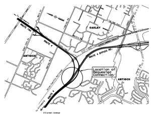
In July 2011, the Bay Area Toll Authority budgeted $7 million to study and design a connector ramp giving drivers a direct route between the Route 4 bypass and the Antioch Bridge. Money left over from a seismic retrofit of the bridge will go toward building the overpass, which would connect the bypass to Route 160. Bridge tolls paid for the retrofit. The nearly $50 million overpass, on the Oakley-Antioch border, would take about three years to complete.
In April 2012, it was reported that a project to build a freeway connector ramp between the Route 4 bypass and the Antioch Bridge is getting about $1.4 million in local developer funds. The additional funds will widen the bridge structure of the ramp from the bypass north to Route 160, allowing BART trains to pass underneath someday. The ramp, located on the Oakley-Antioch border, is estimated to cost about $50 million. The design change adds a sliver of road to the northeast of the ramp and improves the bridge's geometry for the BART tracks. Since the Route 4 bypass opened in 2008, drivers headed north toward Sacramento County have had to cut through Oakley side streets or drive two miles west to the Hillcrest Avenue exit, leave the freeway and enter in the other direction to cross the bridge. The overpass, which is funded by leftover money from a seismic retrofit of the bridge, will take about three years to complete and could start by spring 2014.
In July 2012, it was reported by Ron Langum that Bypass Road, stretching from Marsh Creek Road to Route 4, has officially been designated Route 4. The date of the change was some time between April and July 2012. The official route traveling east is now traveling straight onto the new freeway, which becomes a 2-4 lane road south of Lone Tree, then a left turn onto Marsh Creek Road, then a right turn onto the old Route 4 just outside Discovery Bay. The old Route 4, which turned left toward the Antioch Bridge, is now Route 160.
Mokelumne Trail pedestrian and bicycle bridge (near PM CC R33.382)
In March 2017, it was reported that the Brentwood City
Council supported the construction of a pedestrian and bike bridge over
Route 4 (near PM CC R33.382), finally connecting Mokelumne Trail’s
two sides. The resolution supported the findings in eBART’s Next
Segment Study, which outlined multiple options for transit stations past
the new Hillcrest Station in Antioch, but argued for the next
station’s location to be at Mokelumne Trail and Route 4. The City
Council also supported the construction of the Mokelumne Trail pedestrian
and bicycle bridge over Route 4, south of Lone Tree Road for future access
to potential interim and permanent stations. The multi-span bridge would
be 12 feet wide, stretching between two earthen embankments on either side
of Route 4 with a support column in the highway median. Bicyclists
and pedestrians were promised a connection of Mokelumne Trail in 2004
after Route 4 cut off Marsh Creek Trail, Delta de Anza Trail and the
Mokelumne Trail. However, two of the three were connected, but not
Mokelumne Trail. While only $522,000 of the total $8 million project
secured, the city plans to work with the state Department of
Transportation, BART, Contra Costa Transportation Authority and Tri-Delta
Transit on funding. There is an information page on the overcrossing.
(Source: East Bay Times, 3/15/2017)
In July 2023, it was reported that in June 2023 MTC
last month formally approved the first allocations of Regional Measure 3
dollars, releasing over $270 million for nine projects for which the
sponsors already were moving ahead under Letters of No Prejudice. These
initial allocations included: Contra Costa Transportation Authority: $13
million for the Mokelumne Trail Bicycle/Pedestrian Overcrossing at Route 4.
(Source: MTG/ABAG Bay Link Blog, 7/12/2023)
Balfour Road Interchange (~ CC R35.546)
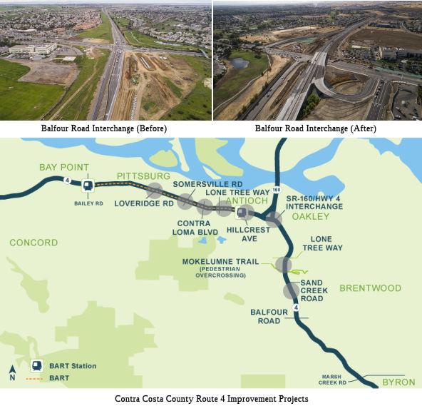 In December 2018, it was reported that a newly redesigned interchange where Route 4 meets Balfour
Road (~ CC R35.546) has opened, replacing a four-way, signalized
intersection. The $42 million project is expected to ease traffic flow in
the busy south Brentwood stretch of Route 4. Included in the project,
which broke ground in spring of 2017, was the installation of a Route 4
bridge crossing over Balfour Road, new loop on-ramps for Balfour Road
traffic, and new diagonal off-ramps from Route 4 to Balfour Road. State
Assemblyman Jim Frazier, D-Discovery Bay, former chairman of the Route 4
Bypass Authority board, was part of the project’s early planning and
noted it wasn’t easy to get the necessary funding. The first big
physical hurdle was a Contra Costa Water District 90-inch pipeline from
Los Vaqueros Reservoir to the Contra Costa Canal that stood in the way.
Officials later devised a plan to move the roadway instead, saving $18
million in the process. The eastbound lanes were completed in July 2018,
but the final phase wasn’t done until early December 2018 when the
westbound lanes were paved and striped. When the details are completed,
Balfour Road will be striped green for bicycle lanes in both directions
and provide sidewalks for safe pedestrian access, traffic authorities
said. The interchange is the final phase of bypass construction on Route 4. It was developed jointly by the Contra Costa Transportation Authority
and the cities of Brentwood, Antioch and Oakley. The Balfour project was
funded through Measure J funds, as well as East Contra Costa Regional Fee
and Financing Authority and Contra Costa Water District. The interchange
was the final of several Highway 4 projects funded to enhance the quality
of life for the more than 250,000 residents of eastern Contra Costa
County, transportation officials said. Others included widening the
stretch from Leland Road in Pittsburg to State Route 160 in Antioch to
eight lanes; adding missing connector ramps at the State Route 160/Highway
4 interchange; and adding a BART extension from Pittsburg to Antioch.
These projects, along with previously constructed ones in the region,
bring the total costs of transportation improvements to East County to
$1.3 billion, officials said.
In December 2018, it was reported that a newly redesigned interchange where Route 4 meets Balfour
Road (~ CC R35.546) has opened, replacing a four-way, signalized
intersection. The $42 million project is expected to ease traffic flow in
the busy south Brentwood stretch of Route 4. Included in the project,
which broke ground in spring of 2017, was the installation of a Route 4
bridge crossing over Balfour Road, new loop on-ramps for Balfour Road
traffic, and new diagonal off-ramps from Route 4 to Balfour Road. State
Assemblyman Jim Frazier, D-Discovery Bay, former chairman of the Route 4
Bypass Authority board, was part of the project’s early planning and
noted it wasn’t easy to get the necessary funding. The first big
physical hurdle was a Contra Costa Water District 90-inch pipeline from
Los Vaqueros Reservoir to the Contra Costa Canal that stood in the way.
Officials later devised a plan to move the roadway instead, saving $18
million in the process. The eastbound lanes were completed in July 2018,
but the final phase wasn’t done until early December 2018 when the
westbound lanes were paved and striped. When the details are completed,
Balfour Road will be striped green for bicycle lanes in both directions
and provide sidewalks for safe pedestrian access, traffic authorities
said. The interchange is the final phase of bypass construction on Route 4. It was developed jointly by the Contra Costa Transportation Authority
and the cities of Brentwood, Antioch and Oakley. The Balfour project was
funded through Measure J funds, as well as East Contra Costa Regional Fee
and Financing Authority and Contra Costa Water District. The interchange
was the final of several Highway 4 projects funded to enhance the quality
of life for the more than 250,000 residents of eastern Contra Costa
County, transportation officials said. Others included widening the
stretch from Leland Road in Pittsburg to State Route 160 in Antioch to
eight lanes; adding missing connector ramps at the State Route 160/Highway
4 interchange; and adding a BART extension from Pittsburg to Antioch.
These projects, along with previously constructed ones in the region,
bring the total costs of transportation improvements to East County to
$1.3 billion, officials said.
(Source: East Bay Times, 12/11/2018)
Continued Upgrade to Route 84 / Vasco Road
According to Ronald Kappesser, Route 4 East of Antioch should be upgraded to a freeway to at least Vasco (004 CC R38.025) by 2011-2015. It is being built by a special purpose construction authority that is funded by development fees (see http://www.sr4bypass.org/ for info). The first segment was completed and opened to traffic in February 2008 (specifically between Route 160 and Lone Tree Way). As for what to do at the new freeway end, Caltrans is studying building the long-delayed route Route 239, which would be a road extending from somewhere around Antioch (say the end of the newly extended freeway portion of Route 4) to Tracy and upgrading the rest of Route 4 to Stockton. Neither of these is certain. Also, there has been a proposal to declare Vasco Road to be Route 84 and using state highway funds to improve the Alameda county section. If this is done, some believe that Route 84 might be redesignated or cosigned with Route 4. Note that this differs from the 1953 planned freeway, which would have bypassed Brentwood to the north, then continued due east over the Orwood Tract and Woodward Island, eventually ending on the Upper Jones Tract at the terminus for the Woodward Island Ferry. Apparantly, Island Road on the Upper Jones Tract up to Route 4 would have been assimilated into the route as well.
Old River Bridge (10-CC, SJ-4, PM 48.2/0.1)
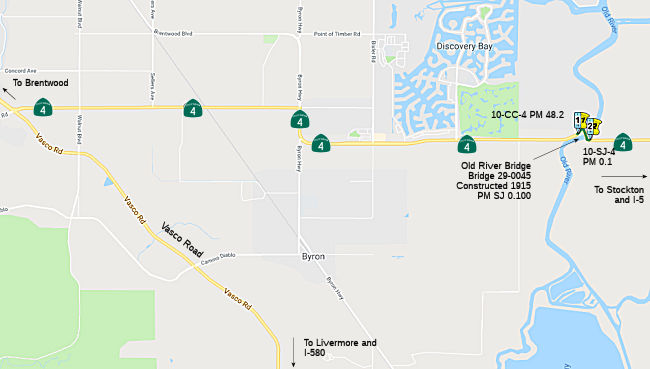 In October 2018, the CTC approved forfor future consideration of funding the following project for
which a Mitigated Negative Declaration (MND) has been completed: Route 4
in Contra Costa and San Joaquin Counties (10-CC, SJ-4, PM 48.2/0.1).
Rehabilitate the mechanical and electrical systems of an existing bridge
on Route 4 at the county line of Contra Costa and San Joaquin Counties.
(PPNO 3113) This project is located on Route 4, at the Contra Costa/ San
Joaquin County line. The project proposes to rehabilitate the mechanical
and electrical systems that enable the operation of the bridge. The
proposed project addresses the need to reduce the delay or minimize the
bridge’s future rehabilitation needs and allow the bridge in
operating condition to be in compliance with Title 33, Code of Federal
Regulations 117.183. The project also proposes to implement structural
repairs and upgrade guardrails to current standards. The proposed project
is currently estimated to cost approximately $9.8 million. This project is
fully funded and is currently programmed in the 2018 SHOPP for
approximately $9.3 million which includes Construction (capital and
support) and Right of Way (capital and support). Construction is estimated
to begin in fiscal year 2020-21. The scope, as described for the preferred
alternative, is consistent with the project scope programmed by the
Commission in the 2018 SHOPP.
In October 2018, the CTC approved forfor future consideration of funding the following project for
which a Mitigated Negative Declaration (MND) has been completed: Route 4
in Contra Costa and San Joaquin Counties (10-CC, SJ-4, PM 48.2/0.1).
Rehabilitate the mechanical and electrical systems of an existing bridge
on Route 4 at the county line of Contra Costa and San Joaquin Counties.
(PPNO 3113) This project is located on Route 4, at the Contra Costa/ San
Joaquin County line. The project proposes to rehabilitate the mechanical
and electrical systems that enable the operation of the bridge. The
proposed project addresses the need to reduce the delay or minimize the
bridge’s future rehabilitation needs and allow the bridge in
operating condition to be in compliance with Title 33, Code of Federal
Regulations 117.183. The project also proposes to implement structural
repairs and upgrade guardrails to current standards. The proposed project
is currently estimated to cost approximately $9.8 million. This project is
fully funded and is currently programmed in the 2018 SHOPP for
approximately $9.3 million which includes Construction (capital and
support) and Right of Way (capital and support). Construction is estimated
to begin in fiscal year 2020-21. The scope, as described for the preferred
alternative, is consistent with the project scope programmed by the
Commission in the 2018 SHOPP.
(Source: October 2018 CTC Agenda Item 2.2c.(1))
Middle River Bridge Roadway Realignment Project (10-SJ-4 4.1/4.9)
 The following project was included in the final adopted 2018 SHOPP in March 2018: PPNO 3177. 10-San Joaquin-4 4.1/4.9. Route 4 Near Holt, from 0.3 mile west to 0.5 mile east of Middle River Bridge.
Realign curve, widen shoulders, upgrade guard rail, and install flashing
beacons. Begin Con: 10/21/2020. Total Project Cost: $13,507K.
The following project was included in the final adopted 2018 SHOPP in March 2018: PPNO 3177. 10-San Joaquin-4 4.1/4.9. Route 4 Near Holt, from 0.3 mile west to 0.5 mile east of Middle River Bridge.
Realign curve, widen shoulders, upgrade guard rail, and install flashing
beacons. Begin Con: 10/21/2020. Total Project Cost: $13,507K.
In January 2019, the CTC approved for future
consideration of funding 10-SJ-4, PM 4.1/4.9 Middle River Bridge
Roadway Realignment Project. This project is located at the Middle
River Bridge on Route 4, west of the city of Stockton in San Joaquin
County. The project proposes to realign the approach curve and widen
shoulders on the east end of the Middle River Bridge. The project also
proposes to upgrade safety devices, install flashing beacons, closed
circuit cameras and upgrade guardrail. The estimated total cost for the
proposed project is $13.5 million. The project is fully funded and
programmed in the 2018 SHOPP for an estimated total of $13.5 million,
which includes Construction (capital and support) and Right-of-Way
(capital and support). Construction is estimated to begin in fiscal year
2019-20. The scope, as described for the preferred alternative, is
consistent with the project scope programmed by the Commission in the 2018
SHOPP.
(Source: January 2019 CTC Minutes, Agenda Item 2.2c(1))
Also in January 2019, the CTC approved the following
support allocation: 10-SJ-4 4.1/4.9 PPNO 3177 Proj ID 1016000139. Route 4
Near Holt, from 0.3 mile west to 0.5 mile east of Middle River Bridge.
Realign curve, widen shoulders, upgrade guard rail, and install flashing
beacons. Concurrent consideration of funding under Resolution E-19-07;
January 2019. Allocation: PS&E $1,453,000 R/W Sup $274,000
(Source: January 2019 CTC Minutes, Agenda Item 2.5b.(2a) Item 22)
In October 2021, the CTC approved the following
allocation for construct/construction support phases: $10,518,000. 10-SJ-4
4.5/4.9. PPNO 10-3177; ProjID 1016000139; EA 1F460. Route 4 Near Holt,
from Middle River Bridge to 0.5 mile east of Middle River Bridge. Outcome/Output:
Improve safety by widening shoulders, curve realignment, upgrade guard
rail, and install flashing beacons. This project will reduce the
number and severity of collisions. Allocation: CON ENG $2,006,000; CONST
$7,335,000.
(Source: October 2021 CTC Agenda, Agenda Item
2.5b.(1) #14)
In March 2014, the CTC vacated right of way in the county of San Joaquin along Route 4 between 1.0 mile east and 0.5 mile west of Tracy Boulevard (004 SJ 5.949/SJ 7.039, consisting of superseded highway right of way no longer needed for State highway purposes. The County, was given a 90-day notice of intent to vacate, without protesting such action.
In October 2013, the CTC relinquished right of way in the county of San Joaquin along Route 4 at Tracy Boulevard (004 SJ 6.039), consisting of a realigned and reconstructed county road.
Cross-Town Freeway - Western Extension (W of I-5, Stockton) (~SJ 15.095 to SJ 15.805)
In August 2005, the SJCOG released a study on the feasibility of extending Route 4 west of the I-5/Route 4 interchange in conjunction with providing the necessary access to the Port of Stockton. This extension would complete the gap between the current termini of the Cross Town Freeway (at Fresno Avenue) and the existing 2-lane highway section of Route 4 (also known as Charter Way). This was to address long term growth at the Port of Stockton. A phased approach was recommended:
The study noted that although right-of-way for extension of the Cross-Town Freeway had not been preserved, a freeway agreement currently exists between Caltrans District 10, San Joaquin County, and the City of Stockton that allows the possibility of potential westward extension of Route 4 along its current alignment. Route 4.
Carl Rogers observed in November 2007 that on the western outskirts of Stockton, Daggett Road has been renamed the "Port of Stockton Expressway". The expressway, which intersects and terminates at Route 4, enjoys a northerly jog onto Rough & Ready Island via a new four-laned divided bridge. From there, traffic can bear east towards Navy Street. There is also a four-lane expressway being constructed west of the Navy Drive/West Washington Street intersection. He opines that Route 4 may one day annex one, or both, of the aforementioned expressways, permitting the Route 4 Freeway to transition into--and overlay--Washington Street towards the unconstructed expressway and the existing Port of Stockton Expressway. This might relate to the plans above.
In January 2011, the CTC approved for future consideration of funding a project in San Joaquin County that will construct a new four lane roadway and structure (viaduct) from Fresno Avenue (004 SJ 15.095) to a new interchange at Navy Drive (004 SJ 15.805). The project is programmed in the Trade Corridors Improvement Fund. Construction is estimated to begin in Fiscal Year 2012-13. Total estimated project cost is $193,640,000 for capital and support. Because of the sensitivity of the resources in the project area, an Environmental Impact Report was prepared for the project. Project impacts to community character and cohesion, visual resources, and sensitive noise receptors cannot be mitigated to a below significance level; therefore a Statement of Overriding Considerations was prepared for the project. All other potential impacts associated with the project can be mitigated to below significance through proposed mitigation measures. Additional information on this project may be found at the Caltrans website.
In March 2012, the CTC amended the scope of the Route 4 Crosstown Freeway Extension, which will construct two mixed flow lanes and two auxiliary lanes in each direction in Stockton, from Fresno Avenue to Navy Drive. Specifically, the landscaping project was split off into a separate project.
In January 2016, it was noted that both I-5 and Route 99 have been under major reconstruction for years, and on Route 99 it's
particularly vexing because they are rebuilding and changing interchanges
on the southeast side. Many have gone away temporarily or permanently
during construction. Route 4 West from I-5 is going to be changing, too.
They are going to connect the Crosstown Extension, through the port area,
past I-5 directly to the quaint old part of Route 4 through the Delta,
which will create a single interchange between I-5 and Route 4.
(Source: SJ Mercury News, 1/6/2016)
In December 2016, it was reported that a freeway ramp
extension to the Port of Stockton will be open to motorists by the end of
2016. Caltrans and the San Joaquin Council of Governments on Friday held a
ribbon cutting in December 2016 to celebrate the completion of the Route 4
Ramp Extension on the yet-to-be open roadway that extends the Crosstown
Freeway west from Fresno Avenue to Navy Drive. The $140 million project
included the construction of a four-lane elevated roadway and partial
interchange aimed at reducing truck traffic in neighborhoods such as Boggs
Tract, which is located directly below the new extension. Caltrans
District 10 director Dennis Agar said the agency hopes to have the
extension open by the end of 2016, noting the project will be completed
one year ahead of schedule and $50 million under budget. In the past, the
Crosstown Freeway ended at Fresno Avenue, creating congestion on local
streets as some 6,500 vehicles - including 4,400 long-haul trucks -
traveled through the Boggs Tract community on a daily basis. The on and
off ramps at Fresno Avenue have been removed and replaced with new ones at
Navy Drive, alleviating traffic concerns in the Boggs Tract community. The
old ramps were officially closed on 12/22/2016. The freeway extension
project received about $70 million from Proposition 1B, a 2006
voter-approved transportation bond, as well as $70 million from Measure K,
the county's half-cent sales tax used to fund major transportation
projects. There are plans for a light at Tillie Lewis and Route 4, which
should be installed by January 2017, weather permitting.
(Source: RecordNet, 12/9/2016; CaltransDistrict
10 on FB, 12/22/2016)
In July 2017, observers provided updates on the
Crosstown Freeway. In 2017, the freeway had been completed as far as Navy
Drive. The Fresno Avenue exit and entrance are now closed. The freeway
continues, makes a southward curve, and ends at Navy Drive. Navy is being
widened at this point, between here and Tillie Lewis Drive. On Route 4,
CalTrans has a sign saying that Tillie Lewis is closed to through traffic.
This indicates that the plan is for Route 4 to use Tillie Lewis north to
Navy, turn west, and then go onto the Crosstown Freeway. I noted also that
entrance to the new extension of the Crosstown on Navy Drive says "Route 4
East". As a side note, there is only one traffic light remaining on the
former Bypass Road, now officially Route 4. At Balfour. This intersection
is now under construction to build a true freeway interchange.
(Source: Ron L., 7/18/2017)
In March 2021, the CTC authorized relinquishment of
right of way, consisting of collateral facilities, in the county of San
Joaquin along the Route 4 crosstown extension on Del Norte Street and West
Hazelton Avenue (10-SJ-4-PM R15.1/R15.2, 3 segments) under the terms and
conditions as stated in the freeway agreement dated January 25,
2011. Per the relinquishment map, this looks like two segments
collateral to where Del Norte meets Route 4 on the N side, and one
collateral segment where W. Hazelton dead ends at Route 4 on the N side of
Route 4. The County agreed to waive the 90-day notice requirement and
accept title upon relinquishment by the State by letter dated September 3,
2020.
(Source: March 2021 CTC Agenda, Agenda Item 2.3c)
 Naming
 Route 4 between I-80 and I-680 is informally called the "John
Muir Parkway". This name is not official, although the highway
passes in sight of his home - an historic landmark - in Martinez. John
Muir was was an influential Scottish-American naturalist, author,
environmental philosopher, glaciologist, and early advocate for the
preservation of wilderness in the United States of America. His letters,
essays, and books describing his adventures in nature, especially in the
Sierra Nevada, have been read by millions. His activism has helped to
preserve the Yosemite Valley, Sequoia National Park and many other
wilderness areas. The Sierra Club, which he co-founded, is a prominent
American conservation organization. In his later life, Muir devoted most
of his time to the preservation of the Western forests. As part of the
campaign to make Yosemite a national park, Muir published two landmark
articles on wilderness preservation in The Century Magazine, "The
Treasures of the Yosemite" and "Features of the Proposed Yosemite National
Park"; this helped support the push for U.S. Congress to pass a bill in
1890 establishing Yosemite National Park. The spiritual quality and
enthusiasm toward nature expressed in his writings has inspired readers,
including presidents and congressmen, to take action to help preserve
large nature areas.
Route 4 between I-80 and I-680 is informally called the "John
Muir Parkway". This name is not official, although the highway
passes in sight of his home - an historic landmark - in Martinez. John
Muir was was an influential Scottish-American naturalist, author,
environmental philosopher, glaciologist, and early advocate for the
preservation of wilderness in the United States of America. His letters,
essays, and books describing his adventures in nature, especially in the
Sierra Nevada, have been read by millions. His activism has helped to
preserve the Yosemite Valley, Sequoia National Park and many other
wilderness areas. The Sierra Club, which he co-founded, is a prominent
American conservation organization. In his later life, Muir devoted most
of his time to the preservation of the Western forests. As part of the
campaign to make Yosemite a national park, Muir published two landmark
articles on wilderness preservation in The Century Magazine, "The
Treasures of the Yosemite" and "Features of the Proposed Yosemite National
Park"; this helped support the push for U.S. Congress to pass a bill in
1890 establishing Yosemite National Park. The spiritual quality and
enthusiasm toward nature expressed in his writings has inspired readers,
including presidents and congressmen, to take action to help preserve
large nature areas.
(Image source: AARoads; Wikipedia; National Park Service)
Route 4 between I-680 (004 CC 12.749) and Route 242 (004 CC R14.546) was once named the "Arnold Industrial Highway" by a trade association. It was named by the association that developed the highway apparently in honor of R. R. Arnold, who was the county surveyor and one of those who fathered the idea of the highway. As for the "industrial" part, this is likely because it helped industry transport goods into Richmond, Oakland, and San Francisco. Today, the portions of this route constructed to freeway standards are called the "Industrial Freeway".
 The portion of this route from I-680
(004 CC 12.749) in Martinez to I-5 near Stockton (004 SJ 15.879) is named
the "California Delta Highway", as Route 4 runs through the
Sacramento/San Joaquin River Delta. It was named by Senate Concurrent
Resolution 11, Chapter 46 in 1987.
The portion of this route from I-680
(004 CC 12.749) in Martinez to I-5 near Stockton (004 SJ 15.879) is named
the "California Delta Highway", as Route 4 runs through the
Sacramento/San Joaquin River Delta. It was named by Senate Concurrent
Resolution 11, Chapter 46 in 1987.
(Image source: AARoads)
Route 4 between I-680 and Route 160 is historically part of "El Camino Sierra" (Road to the Mountains).
 The portion of Route 4 located between Laurel Road
(approx. 004 CC R31.395) and Balfour Road (approx. 004 CC R35.597) in the
County of Contra Costa as the "Police Sergeant Scott Lunger Memorial
Highway". It was named in memory of Police Sergeant Scott Paul
Lunger, born in March 1967, in Hayward, California. Lunger was a career
law enforcement officer with the Hayward Police Department who was loved
by family, friends, and colleagues. Sergeant Lunger served with the City
of Hayward Police Department for 15 years, as a member of various
specialty units, including the special duty unit, gang task force, and the
Special Weapons And Tactics team (SWAT), and was loved in his department
as an officer and a supervisor. Sergeant Lunger was also a Reserve Officer
for the Contra Costa County Sheriff’s Department prior to becoming
to a police officer. Sergeant Lunger was a native of the East Bay, born in
Hayward and raised in Dublin, who studied and played football at both
Diablo Valley College and Chico State University. Sergeant Lunger was a
lifelong football fan, football player, and all-around athlete, who served
as assistant softball coach for the Freedom High School softball team in
Oakley, California, and who touched hundreds of lives through his passion
for sports and youth athletics. Sergeant Lunger was also a hard-working
family man who followed in his father’s footsteps by completing the
International Brotherhood of Electrical Workers Local 595’s
apprenticeship program and working his way up to the position of general
foreman prior to his career in law enforcement. Sergeant Lunger died
during a traffic stop in the early morning hours of July 22, 2015, an
occupant of the stopped vehicle opened fire, killing Sergeant Lunger.
Named by Assembly Concurrent Resolution (ACR) 49, 8/30/2017, Res. Chapter
133, Statutes of 2017.
The portion of Route 4 located between Laurel Road
(approx. 004 CC R31.395) and Balfour Road (approx. 004 CC R35.597) in the
County of Contra Costa as the "Police Sergeant Scott Lunger Memorial
Highway". It was named in memory of Police Sergeant Scott Paul
Lunger, born in March 1967, in Hayward, California. Lunger was a career
law enforcement officer with the Hayward Police Department who was loved
by family, friends, and colleagues. Sergeant Lunger served with the City
of Hayward Police Department for 15 years, as a member of various
specialty units, including the special duty unit, gang task force, and the
Special Weapons And Tactics team (SWAT), and was loved in his department
as an officer and a supervisor. Sergeant Lunger was also a Reserve Officer
for the Contra Costa County Sheriff’s Department prior to becoming
to a police officer. Sergeant Lunger was a native of the East Bay, born in
Hayward and raised in Dublin, who studied and played football at both
Diablo Valley College and Chico State University. Sergeant Lunger was a
lifelong football fan, football player, and all-around athlete, who served
as assistant softball coach for the Freedom High School softball team in
Oakley, California, and who touched hundreds of lives through his passion
for sports and youth athletics. Sergeant Lunger was also a hard-working
family man who followed in his father’s footsteps by completing the
International Brotherhood of Electrical Workers Local 595’s
apprenticeship program and working his way up to the position of general
foreman prior to his career in law enforcement. Sergeant Lunger died
during a traffic stop in the early morning hours of July 22, 2015, an
occupant of the stopped vehicle opened fire, killing Sergeant Lunger.
Named by Assembly Concurrent Resolution (ACR) 49, 8/30/2017, Res. Chapter
133, Statutes of 2017.
(Image source: ABC7 News; Brentwood Self Storage)
In September 2018, it was reported that Caltrans
unveiled signs for the Police Sergeant Scott Lunger Memorial Highway, on
Route 4 between Laurel Road in Oakley and Balfour Road in Brentwood.
Lunger, of Brentwood, was 48 years old when he was gunned down near Myrtle
and Lion streets in Hayward about 3:15 a.m. July 22, 2015. He was
pronounced dead at Eden Medical Center in Castro Valley a short time
later. His accused killer, Mark Estrada, is charged with murder for
allegedly shooting Lunger after the sergeant and another officer stopped
his pickup truck for driving erratically. Estrada, 24, of Oakland, is set
to stand trial later in 2018. Lunger, a father of two, served 15 years
with Hayward police force.
(Source: ABC 7, 9/22/2018)
 Named Structures
Joe Eddy McDonald Memorial Overcrossing
 In July 2012, it was reported that Hercules is poised to ask the state to rename a section of Route 4 in honor of former Councilman and
Mayor Joe Eddy McDonald, who died June 9, 2012. The longtime former
postmaster of Hercules and Rodeo was elected to the council in November
2006 and served one four-year term; he was mayor from December 2008 to
December 2009. He was a City Planning Commissioner from 2002 to 2006, the
last 2½ years as chairman. A North Richmond native, McDonald, his
wife Mary Ann and their two daughters moved to Hercules in 1984. Tragedy
struck the family on Oct. 3, 1994, when Kimaree McDonald, 25, and her
cousin Tiffane Spencer, 17, were killed in a crash on what was then a
winding, notoriously dangerous two-lane stretch of Route 4. Joe Eddy and
Mary Ann McDonald spearheaded a campaign to widen and divide the highway,
collecting 10,000 signatures on a petition to state lawmakers, making
presentations to local government agencies, and organizing a community
walk to the Hercules City Council carrying wooden crosses wrapped in
yellow ribbons that represented accident victims killed on the roadway
since the 1970s. The McDonalds' advocacy led to the $86 million Route 4
West divided highway project, which added two lanes and straightened the
highway. They received a Merit Award from the Metropolitan Transportation
Commission in 2002. A draft resolution before the Hercules City Council in
early July 2012 urged the state Legislature to rename the segment of Route 4 from its western end at San Pablo Avenue (004 CC L0.0) east to Franklin
Canyon (004 CC R4.65R) as the Joe Eddy McDonald Memorial Highway.
In July 2012, it was reported that Hercules is poised to ask the state to rename a section of Route 4 in honor of former Councilman and
Mayor Joe Eddy McDonald, who died June 9, 2012. The longtime former
postmaster of Hercules and Rodeo was elected to the council in November
2006 and served one four-year term; he was mayor from December 2008 to
December 2009. He was a City Planning Commissioner from 2002 to 2006, the
last 2½ years as chairman. A North Richmond native, McDonald, his
wife Mary Ann and their two daughters moved to Hercules in 1984. Tragedy
struck the family on Oct. 3, 1994, when Kimaree McDonald, 25, and her
cousin Tiffane Spencer, 17, were killed in a crash on what was then a
winding, notoriously dangerous two-lane stretch of Route 4. Joe Eddy and
Mary Ann McDonald spearheaded a campaign to widen and divide the highway,
collecting 10,000 signatures on a petition to state lawmakers, making
presentations to local government agencies, and organizing a community
walk to the Hercules City Council carrying wooden crosses wrapped in
yellow ribbons that represented accident victims killed on the roadway
since the 1970s. The McDonalds' advocacy led to the $86 million Route 4
West divided highway project, which added two lanes and straightened the
highway. They received a Merit Award from the Metropolitan Transportation
Commission in 2002. A draft resolution before the Hercules City Council in
early July 2012 urged the state Legislature to rename the segment of Route 4 from its western end at San Pablo Avenue (004 CC L0.0) east to Franklin
Canyon (004 CC R4.65R) as the Joe Eddy McDonald Memorial Highway.
(Source: Contra Costa Times, 7/9/12; Image source: PinoleHercules
Patch, 6/18/2012)
With respect to the above, the Willow Avenue Overcrossing over Route 4 (approx. CC-004-R0.711) in Contra Costa County is officially named the "Joe Eddy McDonald Memorial Overcrossing." It was named in memory of Joe Eddy McDonald, who was born in March 1945 in Lewisville, Arkansas. The McDonald Family moved to Richmond, California, in 1950. Joe Eddy McDonald received his primary education in the West Contra Costa Unified School District and graduated from Richmond Union High School. Joe Eddy McDonald enlisted in the United States Navy for a two-year tour of duty. Upon his return, he earned an associate of arts degree in business administration from Contra Costa College and completed professional development courses offered by Duke and Harvard Universities. Joe Eddy McDonald began working for the United States Postal Service in 1966 as a letter carrier, and worked his way through the ranks of the United States Postal Service, eventually becoming postmaster of the Cities of Rodeo and Hercules and serving in that capacity for 19 years until his retirement in 2002. Joe Eddy McDonald lost his daughter Kimaree McDonald and niece Tiffane Spencer in a tragic car accident in October 1994. He then spearheaded a campaign to widen and divide the two-lane stretch of Route 4 on the west side of the County of Contra Costa to keep others from suffering the same tragic fate. Joe Eddy and Mary Ann McDonald collected over 10,000 signatures on a petition to state lawmakers, made presentations to government agencies, and organized a community walk to the Hercules City Council. The McDonald’s advocacy led to an $86 million Route 4 widening project, which added two lanes. Joe Eddy McDonald served as president of the Rodeo and Hercules Rotary Club, as Area II Director of Chapter IV of the National Association of Postmasters of the United States; as master of Monarch Lodge No. 73 for the State of California; and was a founding member of the Black America’s Political Action Committee, a member of the Black American Cultural Association, and a charter member of the National Association for the Advancement of Colored People, Hercules chapter. He also served on the Library Ad Hoc Fundraising Committee and the City of Hercules Planning Commission from December 2002 to November 2006, serving as chairman the last two and one-half years. In 2006, Joe Eddy McDonald successfully campaigned to serve on the Hercules City Council, serving as vice mayor in 2008 and as mayor in 2009. During Joe Eddy McDonald’s tenure on the Hercules City Council, he was a dedicated and effective member of many regional committees, including the Pinole/Hercules Wastewater Management JPA, the West Contra Costa Integrated Waste Management Authority JPA, the Contra Costa Mayors Conference, and the Association of Bay Area Governments Executive Board. McDonald was responsible for the approved agreement with the West Contra Costa Unified School District to retain the music program in Hercules elementary schools and with Contra Costa College to provide classes in the redevelopment project area. It was named on 09/20/13 by SCR 44, Res. Chapter 124, Statutes of 2013.
 The Pine Street overcrossing that crosses Route 4 in the City of Martinez (approx.CC-004-R9.188) is officially
designated the "Martinez Police Sergeant Paul Starzyk Memorial
Overcrossing". It was named in memory of Martinez Police Sergeant
Paul Starzyk, who was born in Madison, Wisconsin, and grew up in DeKalb,
Illinois. Paul Starzyk graduated from Northern Illinois University with a
bachelor of science degree in computer science, and worked for the Bank of
America Corporation in California. After excelling in the banking
industry, Paul Starzyk realized his true calling was in helping others
through a career in law enforcement. Paul Starzyk started his law
enforcement career as a reserve police officer at the Martinez Police
Department in 1992. In 1994, Paul Starzyk became a full-time police
officer, serving the citizens of Martinez on a daily basis. He was a
member of the SWAT team, later became a range master, and ultimately a
SWAT team instructor, and he also developed the active shooter training
for the Martinez Police Department. Paul Starzyk was promoted to police
sergeant in December 2007. On the morning of September 6, 2008, Sergeant
Starzyk responded to a domestic disturbance. A man armed with a handgun
terrorized patrons at a beauty salon and then forced his way into a second
story apartment where his estranged wife's cousin had sought refuge. When
Sergeant Starzyk and his cover officer arrived, they approached the
apartment and heard women screaming and gun fire. Sergeant Starzyk
knowingly and willing placed himself in harms way by confronting the
suspect who was threatening the lives of five occupants of the apartment
after shooting and killing his estranged wife's cousin as Sergeant Starzyk
and his partner approached. Sergeant Starzyk was immediately fired upon by
the suspect and was wounded, but he was able to return fire and fatally
wounded the suspect. Sergeant Starzyk's decisive and heroic actions saved
the lives of two women and three children who were hiding in the
apartment. Sergeant Starzyk did not survive his injuries making the
ultimate sacrifice to protect the five occupants of the apartment.
Sergeant Starzyk was awarded the Medal of Valor posthumously for his
extraordinary and heroic actions. In the event of his death, Sergeant
Starzyk asked that this statement be read at his funeral: "Here is a man
that got all he ever wanted. Great career, good friends, the best wife,
and a great life. He left this world with no regrets. No matter where he
ended up, he is sure he will see some of his coworkers there". Named by
Senate Concurrent Resolution 21, Resolution Chapter 70, on August 18,
2011.
The Pine Street overcrossing that crosses Route 4 in the City of Martinez (approx.CC-004-R9.188) is officially
designated the "Martinez Police Sergeant Paul Starzyk Memorial
Overcrossing". It was named in memory of Martinez Police Sergeant
Paul Starzyk, who was born in Madison, Wisconsin, and grew up in DeKalb,
Illinois. Paul Starzyk graduated from Northern Illinois University with a
bachelor of science degree in computer science, and worked for the Bank of
America Corporation in California. After excelling in the banking
industry, Paul Starzyk realized his true calling was in helping others
through a career in law enforcement. Paul Starzyk started his law
enforcement career as a reserve police officer at the Martinez Police
Department in 1992. In 1994, Paul Starzyk became a full-time police
officer, serving the citizens of Martinez on a daily basis. He was a
member of the SWAT team, later became a range master, and ultimately a
SWAT team instructor, and he also developed the active shooter training
for the Martinez Police Department. Paul Starzyk was promoted to police
sergeant in December 2007. On the morning of September 6, 2008, Sergeant
Starzyk responded to a domestic disturbance. A man armed with a handgun
terrorized patrons at a beauty salon and then forced his way into a second
story apartment where his estranged wife's cousin had sought refuge. When
Sergeant Starzyk and his cover officer arrived, they approached the
apartment and heard women screaming and gun fire. Sergeant Starzyk
knowingly and willing placed himself in harms way by confronting the
suspect who was threatening the lives of five occupants of the apartment
after shooting and killing his estranged wife's cousin as Sergeant Starzyk
and his partner approached. Sergeant Starzyk was immediately fired upon by
the suspect and was wounded, but he was able to return fire and fatally
wounded the suspect. Sergeant Starzyk's decisive and heroic actions saved
the lives of two women and three children who were hiding in the
apartment. Sergeant Starzyk did not survive his injuries making the
ultimate sacrifice to protect the five occupants of the apartment.
Sergeant Starzyk was awarded the Medal of Valor posthumously for his
extraordinary and heroic actions. In the event of his death, Sergeant
Starzyk asked that this statement be read at his funeral: "Here is a man
that got all he ever wanted. Great career, good friends, the best wife,
and a great life. He left this world with no regrets. No matter where he
ended up, he is sure he will see some of his coworkers there". Named by
Senate Concurrent Resolution 21, Resolution Chapter 70, on August 18,
2011.
(Image Source: Hospital Safety Net Blog, 8/16/2011)
 The Harbor Street Overcrossing over Route 4 (approx. CC-004-23.415) in Contra Costa County
is named the “Officer Larry Lasater Memorial Overcrossing”.
This overcrossing was named in memory of Officer Larry Lasater of the
Pittsburg Police Department, who was born on December 12, 1969, and grew
up in the City of Martinez. After graduating from College Park High School
in Pleasant Hill, Lasater attended Diablo Valley College and then the
University of California at Davis where, in 1993, he earned his Bachelor's
Degree in Political Science and History. In 1994, Lasater graduated from
the United States Marine Corps' Officer Candidate School where he was
commissioned as a Second Lieutenant. Lasater devoted six years of his life
to the United States Marine Corps, attaining the rank of Captain as a tank
commander. In 1999, Lasater left his career in the United States Marine
Corps to return to Pleasant Hill. In 2002, Lasater attended the Contra
Costa County Law Enforcement Academy where he was described by the
Lieutenant of the academy as one of the best police recruits, if not the
best police recruit, he had seen. On September 13, 2002, Lasater became a
Pittsburg Police Officer, and in 2004 he was appointed as a member of the
Special Weapons and Tactics (SWAT) team. Lasater was quick to assist his
fellow officers with any task and he always volunteered for additional
assignments. His communication skills and interactions with citizens were
highly praised and he was often commended for his work performance. On
April 24, 2005, three months before the birth of his only child, Cody,
Officer Lasater died in the line of duty after being critically wounded by
gunfire. Named by Senate Concurrent Resolution (SCR) 88, Resolution
Chapter 68, on 8/4/2010.
The Harbor Street Overcrossing over Route 4 (approx. CC-004-23.415) in Contra Costa County
is named the “Officer Larry Lasater Memorial Overcrossing”.
This overcrossing was named in memory of Officer Larry Lasater of the
Pittsburg Police Department, who was born on December 12, 1969, and grew
up in the City of Martinez. After graduating from College Park High School
in Pleasant Hill, Lasater attended Diablo Valley College and then the
University of California at Davis where, in 1993, he earned his Bachelor's
Degree in Political Science and History. In 1994, Lasater graduated from
the United States Marine Corps' Officer Candidate School where he was
commissioned as a Second Lieutenant. Lasater devoted six years of his life
to the United States Marine Corps, attaining the rank of Captain as a tank
commander. In 1999, Lasater left his career in the United States Marine
Corps to return to Pleasant Hill. In 2002, Lasater attended the Contra
Costa County Law Enforcement Academy where he was described by the
Lieutenant of the academy as one of the best police recruits, if not the
best police recruit, he had seen. On September 13, 2002, Lasater became a
Pittsburg Police Officer, and in 2004 he was appointed as a member of the
Special Weapons and Tactics (SWAT) team. Lasater was quick to assist his
fellow officers with any task and he always volunteered for additional
assignments. His communication skills and interactions with citizens were
highly praised and he was often commended for his work performance. On
April 24, 2005, three months before the birth of his only child, Cody,
Officer Lasater died in the line of duty after being critically wounded by
gunfire. Named by Senate Concurrent Resolution (SCR) 88, Resolution
Chapter 68, on 8/4/2010.
(Image Source: Pittsburgh PD on Twitter, 8/24/2018)
 The overcrossing at Route 4 and
Loveridge Road in the City of Pittsburg (approx. CC-004-24.326) in Contra
Costa County is named the "Inspector Raymond J. Giacomelli Memorial
Overcrossing". It was named after Pittsburg Police Inspector Raymond
J. Giacomelli, who was killed on April 15, 2003 while on duty. Inspector
Giacomelli was an honored and respected member of the Pittsburg Police
Department for 23 years. Named by Assembly Concurrent Resolution 115,
Chapter 39, May 3, 2004.
The overcrossing at Route 4 and
Loveridge Road in the City of Pittsburg (approx. CC-004-24.326) in Contra
Costa County is named the "Inspector Raymond J. Giacomelli Memorial
Overcrossing". It was named after Pittsburg Police Inspector Raymond
J. Giacomelli, who was killed on April 15, 2003 while on duty. Inspector
Giacomelli was an honored and respected member of the Pittsburg Police
Department for 23 years. Named by Assembly Concurrent Resolution 115,
Chapter 39, May 3, 2004.
(Image Source: City of Pittsburgh Memorial Page)
 Double Fine Zones
Between the intersection with the Cummings Skyway and Route 80. Authorized by Senate Bill 155, Chapter 169, on July 23, 1999.
Between the city limits of Brentwood and the Contra Costa-San Joaquin county line. Authorized by SB 1349, Chapter 378, on September 5, 2002. This bill also deleted as a double-fine zone the segment from the intersection with the Cummings Skyway and Route 80. that had been authorized by Senate Bill 155, Chapter 169, on July 23, 1999.
 Classified Landcaped Freeway
The following segments are designated as Classified Landscaped Freeway:
| County | Route | Starting PM | Ending PM |
| Contra Costa | 4 | R8.29 | R8.70 |
| Contra Costa | 4 | R9.06 | R9.33 |
| Contra Costa | 4 | R9.73 | R11.12 |
| Contra Costa | 4 | T14.00 | R15.07 |
| Contra Costa | 4 | 19.91 | 20.51 |
| Contra Costa | 4 | 20.57 | 22.29 |
| Contra Costa | 4 | 22.90 | 24.22 |
| Contra Costa | 4 | 25.28 | R28.55 |
 National Trails
 This route is part of the De Anza National Historic Trail.
Post 1964 Signage HistoryIn 1994, this segment was created by a split of the original segment (a) Route 80 near Hercules to Route 99 near Stockton via north of Concord and via Antioch (changed to "in Hercules" in 1990). This actually was the entire portion of Route 4 that had been multiplexed with US 50 in Stockton (when Route 4 still ran down Charter Way), which was replaced by a freeway routing.
In Stockton, the freeway routing replaced a routing along Charter Way, which still has some vestiges of signing from the pre-freeway days. Travelling along westbound Charter Way, away from Route 99, there is reflectorised green signage at the Mariposa Road intersection. The new signage shows a Route 4 (shield) leading west onto Charter Way. A lefthand (i.e., eastbound) turn places you along Mariposa Road. The signage at Charter/Mariposa seems to be placed for the convenience of local motorists heading in and out of town. In modern times, Route 4 undisputedly follows Charter Way to the west of I-5. Mariposa Street leads towards undisputed Route 4 to the east of Route 99.
The Crosstown Freeway in Stockton actually is part of Route 4 and is
signed as such from both north and south I-5. But it's signed as Route 4
East. If you're going north on I-5, the first interchange you get to is
Charter Way, which is Route 4 West only, and confusing if you don't
distinguish between the different interchanges from I-5 to the two
directions of Route 4. Further confusing things is the fact that Charter
Way in Stockton is called Dr. Martin Luther King Way between I-5 and Route 99, but many businesses and signs refer to it still as Charter Way.
(Source: SJ Mercury News, 1/6/2016)
Technically, the section of Route 4 between the stub-end at Navy Drive in
Stockton to the present expressway starting at the intersection of Vasco
Road and Marsh Creek Road in Brentwood is still a part of the California
Freeway & Expressway System. Practically, the likelihood of a freeway
being built anywhere near the present levee-riding Route 4 alignment is
virtually nil because of environmental considerations. The Delta is
considered endangered; building a freeway across its midst would be seen
both within the current Caltrans administration and other relevant
agencies as exacerbating the various problems. The only freeway with a
fighting chance of being deployed as an extension of the Brentwood Bypass
would be one along the Route 239 alignment down to the I-580/205 junction.
Since the Delta begins within a mile or so west of the Navy Dr. terminus,
that'll likely remain in its present state for the foreseeable future. The
Ort J. Loftus freeway between I-5 and Route 99 was constructed as its own
independent route to fulfill a longstanding regional traffic need; it was
opened to traffic in late 1992 or early 1993.
(Source: Scott Parker on AARoads, "Re: CA 4 west of I-5 to I-80 ", 12/31/2019)
Pre 1964 Signage HistoryThe original routing along Charter Way between I-5 (well, former US 50) and Route 99 (former US 99) was LRN 5 (defined in 1909/1910), but also overlapped with the 1931 definition of LRN 75. Specifically, Route 4 entered town on LRN 75 (1931) as far as Center St/El Dorado St. It then ran cosigned with LRN 5 (US 50) from Center St/El Dorado St. to Mariposa Road along Charter Way until it reached Wilson Way. At that point, Route 4 was cosigned with US 99 (LRN 4), along Charter Way and Marisposa Road. At Farmington, LRN 75 split back off again. In 1951 (Chapter 1562), the portion that was LRN 4 was changed to LRN 75, when LRN 4 was assigned to the Stockton Bypass.
In 1934, this segment was signed as part of Route 4 (Jct. US 40 at Pinole [just S of Hercules] to Jct. Route 89 near Markleeville, via Stockton).
StatusIn January 2022, the CTC authorized relinquishment of right of way,
consisting of collateral facilities, in the city of Stockton along the
Route 4 crosstown extension on Navy Drive (10-SJ-4-PM T14.3/T14.9, 3
Segments). The City, under the terms and conditions as stated in the
freeway agreement dated February 8, 2011, agreed to accept title upon
relinquishment by the State. The 90-day notice was acknowledged on
September 29, 2021, and the 90-day period expired on December 21, 2021.
This is frontage land along Navy Road right where this freeway segment
starts on the western end from just W of the start of the freeway to
Tillie Lewis Dr.
(Source: January 2022 CTC Agenda, Agenda Item 2.3c)
The CTC considered relinquishement of right of way in the City of Stockton, between Filbert Street (004 SJ R18.755) and Route 99 (004 SJ R19.279), consisting of reconstructed and relocated city streets and frontage roads, in November 2005.
The following segments are designated as Classified Landscaped Freeway:
| County | Route | Starting PM | Ending PM |
| San Joaquin | 4 | 15.32 | 16.20 |
| San Joaquin | 4 | R16.31 | R17.07 |
| San Joaquin | 4 | R17.44 | R19.44 |
 Interstate Submissions
(1) and (2) were submitted for inclusion in the interstate system in 1945, but not accepted.
Naming The segment is named the "Ort J. Lofthus Freeway".
Ort Lofthus was a leader Stockton's business community in the radio,
television and cable industries, and worked diligently for the completion
of I-5 through Stockton which was opened October 13, 1979. He was also a
tireless proponent for the construction of Route 4, linking I-5 to Route 99. When the freeway opened, Lofthus held a banquet at which he served
"giant turkey legs" as an insult to then Caltrans director Adrianna
Gianturco, whom he blamed for the delays in getting the highway (in
actually, it was budget problems that led to the delay). He as a native of
Minnesota. It was named by Assembly Concurrent Resolution No. 95, Chapter
51, in 1986
The segment is named the "Ort J. Lofthus Freeway".
Ort Lofthus was a leader Stockton's business community in the radio,
television and cable industries, and worked diligently for the completion
of I-5 through Stockton which was opened October 13, 1979. He was also a
tireless proponent for the construction of Route 4, linking I-5 to Route 99. When the freeway opened, Lofthus held a banquet at which he served
"giant turkey legs" as an insult to then Caltrans director Adrianna
Gianturco, whom he blamed for the delays in getting the highway (in
actually, it was budget problems that led to the delay). He as a native of
Minnesota. It was named by Assembly Concurrent Resolution No. 95, Chapter
51, in 1986
(Image source: Historical Marker Database; RecordNet)
 The portion of Route 4 from I-5 (SJ R16.059) to Route 99 (SJ R19.407) in the
City of Stockton is named the “Officer Jimmy Arty Inn Memorial
Highway”. It was named in memory of Jimmy Arty Inn, a City of
Stockton resident who attended Ronald E. McNair High School and was a
graduate of San Joaquin Delta College’s Basic Peace Officer
Standards and Training (POST) Academy. Officer Jimmy Arty Inn, at 30 years
of age, was hired by the Stockton Police Department (SPD) in December 2015
and was most recently assigned to the Field Operations Division, where he
was also a member of the SPD Honor Guard. At approximately 9:45 a.m. on
Tuesday, May 11, 2021, Stockton Police Officer Jimmy Arty Inn responded to
a disturbance call in the 4400 block of La Cresta Way after a caller
reported hearing screaming, saw a woman with a ripped shirt who was
bleeding and appeared to have been assaulted. Shortly after arriving on
scene, Officer Inn was in front of the residence when he was shot by the
suspect. A second Uniformed Stockton Police Officer arrived on scene and
fired his duty weapon at the suspect, who then briefly entered his home
and returned moments later holding a young child and began to strangle the
child and refused to comply with the officer’s commands. A community
member tackled the suspect and as the second officer approached, that
officer discharged his duty weapon, striking the suspect. Stockton Police
Officer Jimmy Arty Inn was transported to a local hospital where he died
from his injuries, and the suspect was also transported to an area
hospital where he also died from his injuries. Named by Assembly
Resolution ACR 195, Res. Chapter 164, 08/30/22. The sign was installed and dedicated in June 2023.
The portion of Route 4 from I-5 (SJ R16.059) to Route 99 (SJ R19.407) in the
City of Stockton is named the “Officer Jimmy Arty Inn Memorial
Highway”. It was named in memory of Jimmy Arty Inn, a City of
Stockton resident who attended Ronald E. McNair High School and was a
graduate of San Joaquin Delta College’s Basic Peace Officer
Standards and Training (POST) Academy. Officer Jimmy Arty Inn, at 30 years
of age, was hired by the Stockton Police Department (SPD) in December 2015
and was most recently assigned to the Field Operations Division, where he
was also a member of the SPD Honor Guard. At approximately 9:45 a.m. on
Tuesday, May 11, 2021, Stockton Police Officer Jimmy Arty Inn responded to
a disturbance call in the 4400 block of La Cresta Way after a caller
reported hearing screaming, saw a woman with a ripped shirt who was
bleeding and appeared to have been assaulted. Shortly after arriving on
scene, Officer Inn was in front of the residence when he was shot by the
suspect. A second Uniformed Stockton Police Officer arrived on scene and
fired his duty weapon at the suspect, who then briefly entered his home
and returned moments later holding a young child and began to strangle the
child and refused to comply with the officer’s commands. A community
member tackled the suspect and as the second officer approached, that
officer discharged his duty weapon, striking the suspect. Stockton Police
Officer Jimmy Arty Inn was transported to a local hospital where he died
from his injuries, and the suspect was also transported to an area
hospital where he also died from his injuries. Named by Assembly
Resolution ACR 195, Res. Chapter 164, 08/30/22. The sign was installed and dedicated in June 2023.
(Image source: Recordnet; Fox 40 News, 6/22/2023)
 Freeway
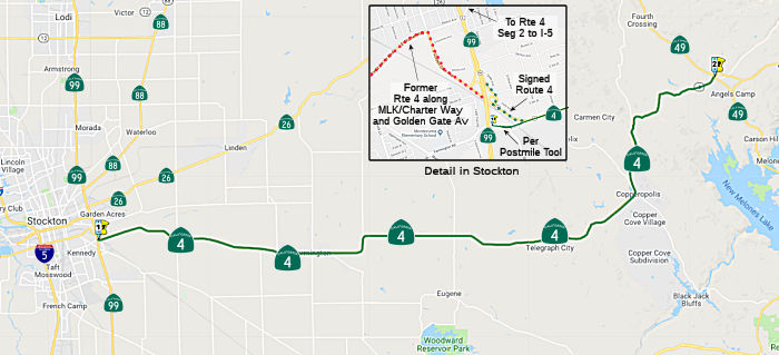 From Route 99 in Stockton to Route 49 at Altaville via the vicinity of
Copperopolis.
From Route 99 in Stockton to Route 49 at Altaville via the vicinity of
Copperopolis.
Post 1964 Signage HistoryIn 1963, this segment was defined by Chapter 385 as "Route 99 near Stockton to Route 49 near Altaville via Copperopolis", but a later act, Chapter 1698, changed the wording to "Route 99 near Stockton to Route 49 near Altaville via the vicinity of Copperopolis".
Pre 1964 Signage HistoryThis was part of the original 1931 definition of LRN 75. Circa 1935, this route was under construction between Farmington and Altaville.
In 1934, this segment was signed as part of Route 4 (Jct. US 40 at Pinole [just S of Hercules] to Jct. Route 89 near Markleeville, via Stockton).
StatusThe SAFETEA-LU act, enacted in August 2005 as the reauthorization of TEA-21, provided the following expenditures on or near this route:
Del Rey Court to South Walker Widening (10-SJ-4 20.5/20.9)
In January 2021, the CTC amended the following project
into the 2020 SHOPP: (1a) #16 10-SJ-4 20.5/20.9 PPNO 3492 ProjID
1020000103 EA 1L280. Route 4 Near Stockton, from east of Del Rey Court to
east of South Walker Lane. Widen highway and construct a channelized
left-turn lane.PA&ED $847K; PS&E $1,305K; R/W Sup $431K; Con Sup
$820K; R/W Cap $261K; Const Cap $2,429K TOTAL $6,093K. Begin const.
1/17/2025.
(Source: January 2021 CTC Agenda, Agenda Item
2.1a.(1a) #16)
In January 2021, the CTC approved the following
pre-construction support phase allocation(s): (2a) #35. $847,000
(PA&ED). 10-SJ-4 20.5/20.9. PPNO 10-3492; ProjID 1020000103; EA 1L280.
Route 4 Near Stockton, from east of Del Rey Court to east of South Walker
Lane. Widen highway and construct a channelized left-turn lane.
(Concurrent Amendment under SHOPP Amendment 20H-005; January 2021.) Prog
Year 23-24.
(Source: January 2021 CTC Agenda, Agenda Item
2.5b.(2a) #35)
In August 2022, the CTC approved the following
pre-construction phase allocation: $1,736,000. 10-SJ-4 20.5/20.9. PPNO
10-3492; ProjID 1020000103; EA 1L280. Route 4 Near Stockton, from east of
Del Rey Court to east of South Walker Lane. Widen highway and
construct a channelized left-turn lane. Allocation: FY23-24 PS&E
$1,305,000; R/W Sup $431,000.
(Source: August 2022 CTC Agenda, Agenda Item 2.5b.(2a) #23)
The 2022 SHOPP included the following new project: 10-STA-4 7.3. PPNO
3526; ProjID 1020000178; EA 1H230. Route 4 Near Copperopolis, at Hoods
Creek Bridge № 38-0041. Replace bridge.Total project cost:
$19,369K. Begin Con: 9/23/2026.
(Source: “2022 State Highway Operation
And Protection Program, Fiscal Years 2022-23 through 2025-26”,
March 17, 2022)
Route 4 Wagon Trail Realignment Project (Western Segment) (10-Cal-4 R10.3/15.8)
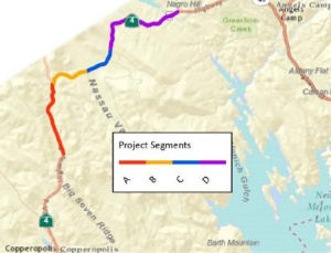 In April 2016, it was reported that, despite a funding
shortfall that might have forced its forward progress to a halt, plans
seem back on track for the Mother Lode’s Highway 4 Wagon Trail
project. Phase one of the project focuses on improvements to a critical
area along a six mile corridor of Route 4 that runs between east of Pool
Station Road (004 CAL R14.705) to the Appaloosa Road intersection (004 CAL
15.847). Estimated costs include design completion this fiscal year at
nearly $2.5 million and almost $4.2 million for right-of-way and
construction next year. According to CCOG Executive Director Melissa Eads,
CTC staff initially got back with her office in early April 2016 with
plans to cut the Wagon Trail phase one construction phase by $2.8 million,
also recommending delaying earlier project development phases in the
works. However, she stresses that CTC and Caltrans headquarters remained
supportive of the project and were looking to help align its programming
schedule to optimize funding opportunities. In addition to state
transportation improvement (STIP) funds, Caltrans has conditionally
proffered a $10.3 million a state highway operation and protection (SHOPP)
pilot grant, which is still subject to final approval from Caltrans
headquarters and CTC. Eads recounts that she contacted the public works
department about potentially applying road impact mitigation fee (RIM)
funds towards the Route 4 improvements. The move would further enable the
tapping of State Only regional improvement program (RIP) funding, which
allows the project to compete for federal monies.
In April 2016, it was reported that, despite a funding
shortfall that might have forced its forward progress to a halt, plans
seem back on track for the Mother Lode’s Highway 4 Wagon Trail
project. Phase one of the project focuses on improvements to a critical
area along a six mile corridor of Route 4 that runs between east of Pool
Station Road (004 CAL R14.705) to the Appaloosa Road intersection (004 CAL
15.847). Estimated costs include design completion this fiscal year at
nearly $2.5 million and almost $4.2 million for right-of-way and
construction next year. According to CCOG Executive Director Melissa Eads,
CTC staff initially got back with her office in early April 2016 with
plans to cut the Wagon Trail phase one construction phase by $2.8 million,
also recommending delaying earlier project development phases in the
works. However, she stresses that CTC and Caltrans headquarters remained
supportive of the project and were looking to help align its programming
schedule to optimize funding opportunities. In addition to state
transportation improvement (STIP) funds, Caltrans has conditionally
proffered a $10.3 million a state highway operation and protection (SHOPP)
pilot grant, which is still subject to final approval from Caltrans
headquarters and CTC. Eads recounts that she contacted the public works
department about potentially applying road impact mitigation fee (RIM)
funds towards the Route 4 improvements. The move would further enable the
tapping of State Only regional improvement program (RIP) funding, which
allows the project to compete for federal monies.
(Source: MyMotherLode.Com, 4/26/2016)
In June 2017, the CTC approved for future consideration of funding the 10-Cal-4, PM 12.66/19.10 Route 4 Wagon Trail Realignment Project, which realigns a segment of Route 4 east of Copperopolis in Calaveras County. The new aligned segment includes standard-width lanes and paved shoulders. The project is partially funded and currently programmed in the 2014 State Transportation Improvement Program (STIP) for an estimated $17.6 million construction (capital) and Right of Way (capital and support). The project is a candidate for the State Highway Operation and Protection Program Asset Management Pilot Program for $10.3 million. It is proposed the project be built in phases. Total estimated project cost is projected to be $94.6 million and estimated to begin in Fiscal Year 2020-21. The scope, as described for the preferred alternative, is consistent with the project scope programmed by the Commission in the 2014 STIP. A copy of the MND has been provided to Commission staff. The project will result in less than significant impacts to the environment after mitigation. The following resource areas may be impacted by the project: Real Property acquisition, cultural resources, and biological resources. Avoidance and minimization measures will reduce any potential effects on the environment. These measures include, but are not limited to, property owners will be treated in compliance of the California Department of Transportation Relocation Assistance Program, the project will adhere to the conditions of the Programmatic Agreement between the California Department of Transportation and the California State Historic Preservation Officer, biological monitoring and pre-construction surveys will be conducted, and conditions contained in the U.S. Fish and Wildlife Biological Opinion will be adhered to. As a result, an MND was completed for this project.
 In October 2017, the CTC authorized the following
financial allocation: 10-Cal-4 R10.3/16.4: On Route 4 in Calavaras County:
State Route 4 Wagon Trail Realignment. Near Copperopolis and Angels Camp,
from 2.0 miles east of Copperopolis to Stallion Way. Realign roadway.
$2,466,000
In October 2017, the CTC authorized the following
financial allocation: 10-Cal-4 R10.3/16.4: On Route 4 in Calavaras County:
State Route 4 Wagon Trail Realignment. Near Copperopolis and Angels Camp,
from 2.0 miles east of Copperopolis to Stallion Way. Realign roadway.
$2,466,000
The 2018 STIP, approved at the CTC March 2018 meeting, appears to funding in FY18-19 and FY20-21 for PPNO 3067, Rt 4 Wagon Trail Expressway (10-Cal-04 PM R10.3/16.4, but notes it as "Potential SHOPP".
The following project was included in the final adopted 2018 SHOPP: PPNO 3067A. 10-Calaveras-4 R10.3/16.4. On Route 4. Near Copperopolis and Angels Camp, from 2.0 miles east of Main Street to Stallion Way. Realign roadway, implement safety features by improving shoulder width, and rehabilitate culverts. Begin Con: 9/1/2020. Total Project Cost: $10,325K.
In December 2019, the CTC had on its agenda the
following allocation: 10-Cal-4 R10.3/15.8. PPNO 3067 Proj ID 1000000025 EA
0E530. Route 4 Wagon Trail Realignment. Near Copperopolis and Angels Camp,
from 2.0 miles east of Copperopolis to Stallion Way. Realign roadway. R/W
$2,800,000
(Source: December 2019 CTC Agenda, Agenda Item
2.5c.(1) #2)
In March 2020, the CTC appeared to continue some
programming planned for PPNO 3067, while modifying some funding:
(Source: March 2020 CTC Agenda, Item 4.7, 2020 STIP
Adopted 3/25/2020)
| PPNO | Project | Prior | 20-21 | 21-22 | 22-23 | 23-24 | 24-25 |
| 3067 | Rt 4 Wagon Trail Expressway (SHOPP)(ext 6-19) | 2,800K | 0 | 0 | 0 | 0 | 0 |
| 3067 | Rt 4 Wagon Trail Expressway (SHOPP) | 0 | 4,427K | 0 | 0 | 0 | 0 |
| 3067 | Rt 4 Wagon Trail Expressway (SHOPP) | 0 | -4,427K | 8,600K | 0 | 0 | 0 |
| 3067 | Rt 4 Wagon Trail Realignment-Wstrn Segmnt (SHOPP) | 0 | 4,427K | 0 | 0 | 0 | 0 |
 The 2020 SHOPP, approved in May 2020, included the
following Multiple Objective item of interest (carried over from the 2018
SHOPP): 10-Calaveras-4 PM R10.3/16.4 PPNO 3067A Proj ID 1018000164 EA
0E531. Route 4 near Copperopolis and Angels Camp, from 2.0 miles east of
Main Street to Stallion Way. Realign roadway, implement safety features by
improving shoulder width, and rehabilitate culverts. Financial
Contribution Only (FCO) to the Calaveras Council of Governments (CCOG)..
Programmed in FY20-21, with construction scheduled to start in March 2021.
Total contribution from SHOPP funds: $10,325K for construction,
The 2020 SHOPP, approved in May 2020, included the
following Multiple Objective item of interest (carried over from the 2018
SHOPP): 10-Calaveras-4 PM R10.3/16.4 PPNO 3067A Proj ID 1018000164 EA
0E531. Route 4 near Copperopolis and Angels Camp, from 2.0 miles east of
Main Street to Stallion Way. Realign roadway, implement safety features by
improving shoulder width, and rehabilitate culverts. Financial
Contribution Only (FCO) to the Calaveras Council of Governments (CCOG)..
Programmed in FY20-21, with construction scheduled to start in March 2021.
Total contribution from SHOPP funds: $10,325K for construction,
(Source: 2020 Approved SHOPP a/o May 2020)
In June 2020, the CTC approved the following amendment
to the 2020 SHOPP: 10-Cal-4 R10.3/16.4 R14.7/16.1
PPNO 3067A ProjID 1018000164 EA 0E531. Route 4 near Copperopolis and
Angels Camp, from Pool Station Road to west of Appaloosa Way 2.0
miles east of Main Street to Stallion Way. Realign roadway,
implement safety features by improving shoulder width, and rehabilitate
culverts. Financial Contribution Only (FCO) to Calaveras County.
Due to a recent estimate the project limits were shortened to stay within
programmed amount. Updates to the description, post miles, and performance
measure were made to align with new limits. Change in program code to
better align with scope of work.
(Source: June 2020 CTC Agenda, Agenda Item
2.1a.(5d) #24)
In December 2020, it was reported that the California
Transportation Commission awarded $5.9 million to move the project to
construction. It was also reported that at a Calaveras County Board of
Supervisors meeting, the board held a public hearing and unanimously
approved a resolution of necessity to acquire property interests through
eminent domain in order to carry out the Route 4 Wagon Trail Project. The
Wagon Trail project, which has formally been in the works since 2001, aims
to realign and improve a roughly six-mile stretch of Route 4 between
Copperopolis and Angels Camp. Since early 2010, the county and the
California Department of Transportation (Caltrans) have been working to
acquire the properties needed for the project’s right of way. The
county has reached agreements with six of the seven affected property
owners, but has not yet been able to come to an agreement with one
property owner, Tiscornia Ranches, LP. The total properties still needed
include five parcels containing 76.2 acres of land, 1 acre of CalTel
easements, 4.3 acres of PG&E easements and 11.5 acres of temporary
construction easements. The total fair-market value of the properties has
been appraised at $285,000, and an offer in this amount or more has been
made to the property owner. The board was advised to approve the
resolution in order to ensure that the necessary right-of-way could be
acquired and certified by the state ahead of funding deadlines. In order
to receive $10.3 million in funds from the State Highway Operation and
Protection Program (SHOPP), the county has to secure and receive
certification for the right-of-way by May 3, 2021. In addition, $4.4
million in State Transportation Improvement Program (STIP) funds have a
June 2021 funding deadline.
(Source: MyMotherLode.Com, 12/4/2020; Calavaras Enterprise 12/18/2020)
In June 2021, it was reported that Calaveras County, in
partnership with Caltrans and the Calaveras Council of Governments (CCOG),
secured funding to construct a critical portion of the Route 4 Wagon Trail
Realignment project. At its June 2021 meeting, the California
Transportation Commission (CTC) took the official action to allocate a
total of $22 million from various state transportation programs needed for
the County to move forward with construction of the Western Segment of the
Route 4 Wagon Trail Project. The Route 4 Wagon Trail project has been the
region’s highest priority for the past ten years. The Western
Segment of the project consists of realigning approximately 3.2 miles
between Bonanza Way and Appaloosa Road. Construction is anticipated to
start in January 2022 and be complete by late 2023. The County and CCOG
are now working towards funding the remaining Eastern Segment of the Route 4 Wagon Trail project (PPNO 10-3546) from the Cherokee Creek Bridge to
Stockton Road near Angels Camp (10-Cal-4 16.3/R18.769). With that goal in
mind, the County and CCOG have collaborated with Caltrans to replace the
bridge on Route 4 at Cherokee Creek just east of Appaloosa Road. The
Caltrans Cherokee Creek bridge replacement project is approximately $10
million and anticipated to start construction in 2023. Once completed, the
entire Wagon Trail Realignment project will realign and reconstruct
approximately 6.5 miles of Route 4 between Copperopolis and Angels Camp.
Additionally, in June 2021, the CTC allocated $11,680,000 for the
locally-administered Multi-Funded SB 1 LPP (Competitive)/STIP State Route 4 Wagon Trail Realignment (Western Segment) project (PPNO 3067), on the
State Highway System, in Calaveras County, programmed in Fiscal Year
2021-22. Thus, the $22 million allocation included $10,325,000 in SHOPP
allocation funding and $11,680,000 in SB 1 LPP/STIP funding.
(Source: The Pine Tree, 6/24/2021; June 2021 CTC Agenda, Agenda Item 2.5b.(1) #28; June 2021 CTC Agenda, Agenda Item 2.5s.(4) / 2.5v.(2))
In March 2022, it was reported that the Route 4 Wagon
Trail Realignment Project (Western Segment) is finally underway as members
of the local government, Caltrans, and other stakeholders met for a
groundbreaking ceremony at Jordan Oaks Vineyard on Mar. 3, 2022. The
project has been in development since 2001 with preliminary studies
starting in 2008. As many longtime Calaveras County residents know, Route 4 is built on the original wagon trail that connected Copperopolis and
Angels Camp, which explains its extreme twists and turns.
(Source: Calaveras Enterprise, 3/7/2022)
In August 2023, it was reported that after a delay in
getting work started up after the wet winter season, construction is back
underway on the Route 4 Wagon Trail Realignment Project. Crews have
resumed overhauling Route 4 between Pool Station Road and Appaloosa Road.
The delays were due to additional environmental work that had to be
completed before construction could be restarted after the winter. The
project includes realigning the stretch of Route 4 between Angels Camp and
Copperopolis, widening the roadway, removing tight curves, and installing
new culverts and animal crossings. The first phase covers 3.2 miles
between Bonanza Mine Road and Appaloosa Road and is anticipated to be
completed sometime in 2024.
(Source: MyMotherLode.Com, 4/4/2023)
In June 2008, the CTC vacated right of way in the county of Calaveras, between 1.1 and 1.4 miles southerly of Hunt Road, consisting of right of way no longer needed for State highway purposes. (approx CAL-4-13.998)
In December 2013, the CTC relinquished right of way in the county of Calaveras along Route 4 on Pool Station Road, consisting of a realigned and reconstructed county road. It also vacated right of way in the county of Calaveras along Route 4 at Pool Station Road, consisting of superseded highway right of way no longer needed for State highway purposes. (approx CAL R14.704)
West Branch Cherokee Creek Bridge (PM Cal 15.9/16.3)
") In August 2017, the CTC authorized the following SHOPP addition: 10-Cal-4
16.1 Route 4: Near Angels Camp, at West Branch Cherokee Creek Bridge
№ 30-0036. Replace bridge. $278K (R/W) $2,000K (C) $3,341K (Support)
PA&ED: 08/06/2019 R/W: 02/04/2021 RTL: 08/11/2021 BC: 02/28/2022.
PA&ED is the only authorized phase in FY 2017-18.
In August 2017, the CTC authorized the following SHOPP addition: 10-Cal-4
16.1 Route 4: Near Angels Camp, at West Branch Cherokee Creek Bridge
№ 30-0036. Replace bridge. $278K (R/W) $2,000K (C) $3,341K (Support)
PA&ED: 08/06/2019 R/W: 02/04/2021 RTL: 08/11/2021 BC: 02/28/2022.
PA&ED is the only authorized phase in FY 2017-18.
In January 2020, the CTC made a technical amendment of
the 2018 SHOPP item to adjust funding. During the PA&ED phase, it was
determined that the bridge profile needs to be raised by four feet and the
span needs to be lengthened by fifteen feet to accommodate a 100 year
storm event. Increase construction to capital and support to accommodate
the extra work necessary for the change in scope. The CTC also approved
for future consideration of funding the project that proposes to remove
and replace the existing West Branch Cherokee Creek Bridge. This project
addresses poor performance objectives due to deteriorating nonstandard
timber bridge rails. The proposed project will replace the current bridge
rails with current crashworthy railing systems in accordance with American
Association of State Highway and Transportation Official’s ASSHTO)
Manual for Assessing Safety Hardware compliant bridge railing
system. The estimated total cost of the proposed project is $8.5
million and is fully funded. The project is currently programmed in the
2018 SHOPP for an estimated total of $5.7 million that includes
Construction (capital and support) and Right of Way (capital and support).
Construction is estimated to begin in 2022-23. The CTC also approved the
following pre-construction financial allocation: 10-Cal-4 16.1. PPNO 3255.
ProjID 1017000154. EA 1H500. Route 4 Near Angels Camp, at West Branch
Cherokee Creek Bridge № 30-0036. Replace bridge. (Concurrent
consideration of funding under Resolution E-20-09; January 2020.)
(Concurrent Amendment under SHOPP Amendment 18H-014, January 2020.)
PS&E $1,392,000 Programmed $1,530,000 Allocated; R/W Sup $103,000
Programmed $121,000 Allocated.
(Source; January 2020 CTC Agenda, Agenda Item
2.1a.(1d) Item 25, Agenda Item 2.2c.(1), 2.5b.(2b) #9)
The 2020 SHOPP, approved in May 2020, included the
following Bridge Preservation item of interest (carried over from the 2018
SHOPP): 10-Calaveras-4 PM 16.1 PPNO 3255 Proj ID 1017000154 EA 1H500.
Route 4 Near Angels Camp, at West Branch Cherokee Creek Bridge №
30-0036. Replace bridge. Programmed in FY21-22, with construction
scheduled to start in June 2022. Total project cost is $8,078K, with
$4,478K being capital (const and right of way) and $3,600K being support
(engineering, environmental, etc.),
(Source: 2020 Approved SHOPP a/o May 2020)
In May 2021, the CTC amended this project in the
SHOPP: (1d) #52. 10-Cal-4 16.1 15.9/16.3
PPNO 3255 ProjID 1017000154 EA 1H500. Route 4 Near Angels Camp, at West
Branch Cherokee Creek Bridge № 30-0036. Replace bridge. (Additional
$300,000 for PS&E from local contribution.) Amended to adjust
costs. There is an alignment conflict with the western segment of the
planned Wagon Trail project 0E531/PPNO 10-3067A. Increase in construction
capital ($4,200K → $5,786K) to revise the project scope to realign
the bridge to connect to the approach and departure of the planned
adjacent project alignment. Revise project description and postmiles
due to the change to the bridge alignment. Revised total: $9,664K.
(Source: May 2021 CTC Agenda, Agenda Item 2.1a.(1d)
#52)
In August 2022, the CTC approved the following
construction phase allocation: $7,063,000. 10-Cal-4 15.9/16.3. PPNO
10-3255; ProjID 1017000154; EA 1H500. Route 4 Near Angels Camp, at West
Branch Cherokee Creek Bridge № 30-0036. Outcome/Output:
Replace bridge with new structure which meets current standards and
provides shoulders for disabled vehicles, maintenance workers, pedestrians
and bicycles. Additional $300,000 for PS&E from local contribution.
Programmed allocation: CON ENG $1,500,000; CONST $5,786,000. CEQA - ND,
11/26/2019; Re-validation 3/23/2022. NEPA - CE, 10/18/2021; Re-validation
3/23/2022. Future consideration of funding approved under Resolution
E-20-09; January 2020. As part of this allocation request, the Department
is requesting to extend the completion of CONST and CON ENG an additional
44 months beyond the 36 month deadline.
(Source: August 2022 CTC Agenda, Agenda Item
2.5b.(1) #68)
Route 4 Wagon Trail Realignment Project (Eastern Segment) (10-Cal-4 16.3/R18.769)
According to the project page for this project, Route 4
is a major east-west connector through southern Calaveras County; it is a
two-lane highway that traverses mostly rural farmland, characterized by a
rolling terrain that supports rock outcroppings, seasonal streams, and
natural vegetation, as well as agricultural operations. The problem is
that the segment of Route 4 between Copperopolis and Angels Camp does not
meet current design standards. The existing facility has the following
features that, combined with the traffic volumes, reduce the operating
speed of the roadway and do not meet current highway design standards
throughout this segment:
(Source: Route 4 Wagon Trail Realignment Project Page, 11/2022)
The project will improve the segment of Route 4 from
Bonanza Mine Way to Stockton Road from 2.6 miles east of Copperopolis to
about 1.6 miles west of the Route 4/Route 49 junction in Altaville (Angels
Camp). The project will to construct a new alignment with two standard
12-foot width lanes and 8-foot paved shoulders. The project would improve
sight distance by increasing curve radii with the incorporation of longer,
smoother curves. Improvements will include widening, grading and paving
the roadway; removing dangerous curves; installing new culverts and animal
crossings; and improving overall road safety for the traveling public.
(Source: Route 4 Wagon Trail Realignment Project Page, 11/2022; Calavaras County Route 4 Project Page, 11/2022)
In August 2022, the CTC approved an allocation of
$4,500,000 for the Route 4 Wagon Trail Realignment Project (Eastern
Segment) (10-Cal-4 16.3/R18.769) [PPNO 10-3546; ProjID 1022000262;
EA 1Q290]. On Route 4 between the town of Copperopolis and the City of
Angels Camp in Calaveras County. The Eastern Segment of the State Route 4
Wagon Trail Realignment Project consists of constructing Route 4 on a new
alignment between Stallion Way and approximately 1.6 miles west of the
State Route 4 /49 Junction near Stockton Rd. CEQA - MND, 12/29/2016;
Re-validation 01/06/2021. NEPA - CE, 12/29/2016; Re-validation 01/06/2021.
Future consideration of funding approved under Resolution E-17-35; June
2017. Allocation: FY22-23 PS&E $4,500,000. This is a
locally-administered STIP project.
(Source: August 2022 CTC Agenda, Agenda Item
2.5c.(2))
Calaveras 49 Mobility Improvement Project (10-Cal-4, PM R20.8/21.4 10-Cal-49, PM 8.4/9.1)
 The 2020 SHOPP, approved in May 2020, included the
following Collision NEW Long Lead Mobility item of
interest: 10-Calaveras-49 PM 8.5/9.1 PPNO 3434 Proj ID 1017000057 EA
1H010. Route 49 in Angels Camp, on Main Street from north of Stockton Road
to north of Francis Street; also on Route 49 from 0.2 miles west and east
of Main Street (PM R20.9/R21.3). Construct roundabouts, upgrade facilities
to Americans with Disabilities Act (ADA) standards, and enhance pedestrian
and bicyclist safety. Note: Presence of historic properties and cultural
resources require extensive environmental consultations and clearances. A
total of 41 parcels are potentially impacted. Programmed in FY24-25, with
construction scheduled to start at the end of December 2025. Total project
cost is $18,665K, with $12,053K being capital (const and right of way) and
$6,612K being support (engineering, environmental, etc.). Only the
PA&ED (Planning and Environmental) costs of $1,727K are authorized.
The 2020 SHOPP, approved in May 2020, included the
following Collision NEW Long Lead Mobility item of
interest: 10-Calaveras-49 PM 8.5/9.1 PPNO 3434 Proj ID 1017000057 EA
1H010. Route 49 in Angels Camp, on Main Street from north of Stockton Road
to north of Francis Street; also on Route 49 from 0.2 miles west and east
of Main Street (PM R20.9/R21.3). Construct roundabouts, upgrade facilities
to Americans with Disabilities Act (ADA) standards, and enhance pedestrian
and bicyclist safety. Note: Presence of historic properties and cultural
resources require extensive environmental consultations and clearances. A
total of 41 parcels are potentially impacted. Programmed in FY24-25, with
construction scheduled to start at the end of December 2025. Total project
cost is $18,665K, with $12,053K being capital (const and right of way) and
$6,612K being support (engineering, environmental, etc.). Only the
PA&ED (Planning and Environmental) costs of $1,727K are authorized.
(Source: 2020 Approved SHOPP a/o May 2020)
In June 2023, the CTC approved for future consideration
of funding 10-Cal-4, PM R20.8/21.4 10-Cal-49, PM 8.4/9.1. Calaveras
49 Mobility Improvement Project. Make intersection, roadway,
pedestrian, and bicycle improvements on Route 4 and Route 49, in Calaveras
County. (MND) (PPNO 3434) (SHOPP). The project is located on Route 4 from
PM R20.8 to PM 21.4, and Route 49 from PM 8.4 to PM 9.1, in Calaveras
County. The Department proposes to construct roundabouts, upgrade
facilities, and enhance pedestrian and bicycle safety. The project is
currently programmed in the 2022 SHOPP for a total of $19,485,000, which
includes Right of Way (Support and Capital) and Construction (Support and
Capital). Construction is estimated to begin 2026-27. The scope, as
described for the preferred alternative, is consistent with the project
scope as programmed by the Commission in the 2022 SHOPP. A copy of the MND
has been provided to Commission staff. The project will result in less
than significant impacts to the environment after mitigation. The
following resource areas may be impacted by the project: visual aesthetics
due to the loss of heritage oak trees. Avoidance, minimization, and
mitigation measures will reduce any potential effects to the environment.
These measures include, but are not limited to, paying in-lieu fees to the
City of Angels Camp Oak Tree Preservation Fund, per the City of Angels
Camp Oak Tree and Heritage Tree Ordinance. As a result, a MND was
completed for this project.
(Source: June 2023 CTC Agenda, Agenda Item 2.2c.(1) Item 10)
In August 2023, the CTC approved the following SHOPP
Pre-Construction Phase (environmental support, design, and R/W support)
allocation: $3,966,000. 10-Cal-49 8.5/9.1. PPNO 10-3434; ProjID
1017000057; EA 1H010. Route 49 In Angels Camp, on Main Street from north
of Stockton Road to north of Francis Street; also on Route 49 from 0.2
miles west and east of Main Street (PM R20.9/R21.3). Construct
roundabouts, upgrade facilities to Americans with Disabilities Act (ADA)
standards, and enhance pedestrian and bicyclist safety. Concurrent
consideration of funding under Resolution E-23-114; August 2023. Two month
allocation time extension for PS&E and R/W Sup approved under Waiver
23-72; June 2023. Allocation (Programmed / Allocated):
PS&E $2,158,000 / $2,481,000; R/W Sup $1,248,000 / $1,485,000.
(Source: August 2023 CTC Agenda, Agenda Item 2.5b.(2a) #19)
 Scenic Route Freeway
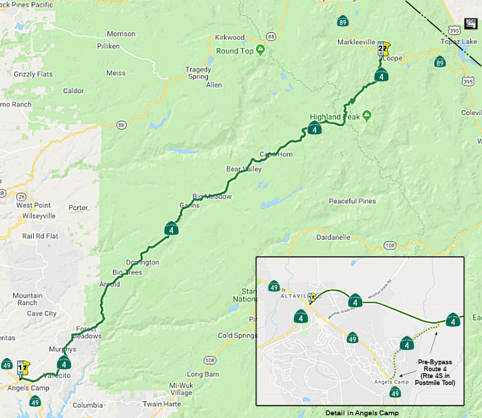 From Route 49 in Angels Camp to Route 89 near Markleeville via Murphys,
Calaveras Big Trees, Dorrington, and Bear Valley.
From Route 49 in Angels Camp to Route 89 near Markleeville via Murphys,
Calaveras Big Trees, Dorrington, and Bear Valley.
Note: It appears that Route 4 is cosigned with Route 89 from near Markleeville to Woodfords (jct. Route 88), for historical reasons that are explained in the pre-1964 numbering section, going back to the time before Route 89 was extended from the jct. with Route 4 to US 395 near Topaz Lake.
Post 1964 Signage HistoryIn 1963, this segment was defined by Chapter 385 as "Route 49 near Angeles[sic] Camp to Route 89 near Mount Bullion via Murphys, Calaveras Big Trees, and Dorrington."
In 1968, this was simplified to "Route 49 near Angels Camp to Route 89 via Murphys, Calaveras Big Trees, and Dorrington."
Route 4 from Route 207 in Bear Valley east over Pacific Grade Summit and
Ebbetts Pass includes approximately 30 miles of one-lane highway that
includes gradients as steep as 24%.
(Source: Gribblenation Blog, "Trans-Sierra Highways; California State Route 4 over Pacific Grade Summit and Ebbetts Pass", September 2020)
Pre 1964 Signage HistoryThe Gribblenation Blog "Trans-Sierra Highways; California State Route 4 over Pacific Grade Summit and Ebbetts Pass" provides a detailed history of Ebbets Pass, which is not repeated here. This provides the background of what would become known as the "Big Trees Road"
On April 15, 1911, the Big Trees Road between Calaveras Big Trees and
Route 89 ("An act to establish the Alpine state highway; to define its
course...") was added to the state highway system by Chapter 468, as an
extension on LRN 23, LRN 24, and LRN 34. Tom Fearer provided more
specifics, noting that the description in the legislation essentially made
the Alpine State Highway a discontinuous segment of the already existing
LRN 24 between Lodi and San Andreas. This same legislation
effectively extended LRN 23 north from Bridgeport over what would come to
be known as Monitor Pass to the Lake Tahoe Wagon Road (LRN 11 and the
future South Lincoln Highway) in Meyers.
(Partial Source: Gribblenation Blog, "Trans-Sierra Highways; California State Route 4 over Pacific Grade Summit and Ebbetts Pass", September 2020)
In 1925, LRN 24 was extended to Route 49 near Angels Camp by "An act declaring the county road in Calaveras county, extending from Angels Camp through Vallecita and Murphy to Calaveras Big Trees in the national forest to be a state highway." (May 23, 1925, Chapter 375). This closed the gap in LRN 24.
In 1934, this segment was signed as part of Route 4 (Jct. US 40 at Pinole [just S of Hercules] to Jct. Route 89 near Markleeville, via Stockton). Future Route 89 between near Markeeville and Woodsford was signed as Route 4 until the completion of Route 89 to US 395 near Topaz Lake in the mid 1950s, at which point the portion from near Markleeville and Woodsford became Route 4 / Route 89.
Note that, until LRN 23 was completed between US 395 and near Markleeville, the segment from near Markleeville to Route 8 (later Route 88) was signed as Route 4, not Route 89, and Route 4 continued cosigned with Route 8 (Route 88) until the Nevada State Line. This cosigning shows on the state highway maps starting in 1948, and remained until the 1964 renumbering; although post 1953, the LRN 23 segment appears to have Route 89, co-signed with Route 4 from near Markeleeville to Woodfords.
Route 4 near Ebbetts Pass wasn't connected to US 395 until 1954 when the
new extension of Route 89/LRN 23 over Monitor Pass opened to
traffic. The dedication ceremony for the new highway over Monitor
Pass took place on September 12, 1954. . The new route over Monitor
Pass established the direction connection between the Alpine County Seat
of Markleeville and Mono County Seat of Bridgeport that was sought in
1911. Route 4 was cut back to it's current eastern terminus at Route 89
during the 1964 Highway Renumbering
(Source: Gribblenation Blog, "Trans-Sierra Highways; California State Route 4 over Pacific Grade Summit and Ebbetts Pass", September 2020)
StatusAngels Camp Bypass (Route 4S)
The September 2002 CTC agenda provided the first indication of the plans to widen this to a two lane expressway in Angels Camp. In November 2002, the CTC adopted of a controlled access highway route from PM R21.1 to PM R23.3 in Calaveras County. The bypass will mean the route will have a crossing of Route 49 rather than the current break in the route and the current co-signed section. The project looks fairly reminiscent of the Amador Bypass but about half the distance.
In 2007, the CTC recommended funding $4,438K from the Corridor Mobility Improvement Account (CMIA) for the Angels Camp Bypass. The bypass was completed and opened on July 21, 2009. The general contractor, Teichert Construction of Stockton, finished the project approximately 18 months early and $5-6 million under budget.
In December 2015, Oscar Voss reported that not only does Route 4 now bypass Angels Camp, but the old alignment is now signed as Business Route 4 (per Google Maps Street View) at the junctions with both Route 49 and Vallecito Rd. (old Route 49). In the Caltrans postmile tool, prior to relinquishment, the route was shown as Route 4S (Vallecito Road).
In June 2013, the CTC authorized relinquishment of right of way in the city of Angels (Angels Camp) adjacent to Route 4 along Casey Street and Gardner Lane, consisting of a non-motorized transportation facility. (appox CAL-4-R21.002 to R21.447)
In April 2012, the CTC authorized relinqishment of right of way in the city of Angels along Route 4 at Easy Street (formerly First and A Streets), consisting of a collateral facility. (approx. CAL-4-R21.504)
In June 2017, the CTC authorized relinquishment of right of way in the city of Angels (Angels Camp) on Route 4 (actually Route 4S) (Vallecito Road) from 98.43 feet (30 meters) east of the east end of the Angels Creek Bridge to Route 49, consisting of superseded highway (10-Cal-4-PM 21.4). The City, by Relinquishment Agreement dated March 30, 2017 agreed to waive the 90-day notice requirement and accept title upon relinquishment by the State.
In January 2011, the CTC authorized relinquishment of right of way in the city of Angels along Route 4 from 98.43 feet (30 meters) east of the east end of the Angels Creek Bridge No. 30-0008 (approx CAL-4S-21.431, 4S evidently being "superseded") to the easterly city limits, consisting of superseded highway right of way. The Angels Creek Bridge a single span reinforced concrete T girder bridge that carried the former alignment of Route 4 across Angel Creek. The Angel Creek Bridge (30 0008) was built in 1946, had some work done in 1960, and is currently rated in fair condition. The bridge is 46 ft long, 37.4 ft wide (edge of deck to edge of deck), and is on a 32 degree skew. It has a sufficiency rating of 76 and carries about 6500 vehicles a day. The girders are supported by end-diaphragm abutments. The creek flows around the abutments without any kind of scour protection.
In August 2011, the CTC relinquished right of way in the County of Calaveras along Route 4 from the easterly city limits of the City of Angels to the realigned Route 4, consisting of superseded highway right of way (former Route 4S) and a new road connection.
In January 2007, the CTC considered vacating right of way in the county of Calaveras, at Batten Road, near Vallecito, consisting of right of way no longer needed for State highway purposes. (approx CAL 26.299))
In November 2005, the CTC considered relinquishment of right of way in the County of Calaveras, on Meko Drive, consisting of a maintenance station access road. (approx CAL 49.577)
In June 2021, it was reported that Construction was scheduled on Route 207 from the Route 4 junction to Mt. Reba Resort, and on Route 4 near
Tamarack from west of Cabbage Patch Log Road (Forest Rte 7N09, ~
10-CAL-004 R59.8) to the Alpine County line (~ 10-CAL-004 R65.855). In
addition to rehabilitating the road surface, the highway will be widened,
re-striped, damaged culverts will be repaired, and rumble strips will be
installed to improve motorists’ safety. Work is scheduled to
continue into Fall 2021. The estimated $4.25 million project will be
performed by George Reed Construction Inc., of Modesto, CA.
(Source: The Pine Tree, 6/15/2021)
According to Chris Velvin: "I just got back from a family trip to Tahoe and Yosemite, for which, I used the Microsoft Streets and Trips software to plot a route. The route that the program gave us took us over Ebbett's Pass on Route 4 from Angel's Camp to Markleesville. I'm sure this is a beautiful drive in the daytime but we got there at about 9PM, in the pitch black. The road is very well maintained but it goes down to one wide lane, with no center stripe, for about 30(?) miles. I could be exaggerating that, but it felt like a hundred miles. There are very few road signs and none that identify the road on that stretch. We thought we had made a wrong turn and were just hoping to end up in the right place. The road is full of blind curves and magestic pines that hide anything beyond 20 feet or so. Three sets of deer and one large SUV jumped out in front of us. There are times when there is nothing on the edge of the raod except black. Is it at 5 foot ditch or a thousand foot crevasse? There was no way to know with out stopping...and we weren't stopping. We were just hoping the road wasn't a dead end and we would have to back track.The closest thing I can compare this part of the trip to is the Blair Witch Project. It was a white knuckle ride the whole way. I can't wait to drive it in the day time, or at night without the in-laws."
NamingThis segment from Calavares Big Trees to Route 89 is named the "Alpine State Highway". It was named by Resolution Chapter 468 in 1911. This segment also had the historic name of the "Big Trees Highway".
 Some portion of this highway is named the Ebbets Pass
Highway. The designation begins about ½ mile east of the town
of Murphys (about 7 miles east of Angels Camp), and continues all the way
over Ebbets Pass to approximately 2 miles west of Markleeville
(the point at which the narrow, winding 1 one lane road widens back out to
standard two lane highway. This pass is named for Major John Ebbett.
Ebbett crossed it with a large train of mules in the spring of 1851. He
had come to California a couple years earlier as captain of the
Knickerbocker Exploring Company. He died in a ship wreck in the Bay Area
April 15, 1854. The pass is known to have been used by Miwok and Washoe
Indians prior to the coming of the White people. The name was made
official in 1893 by action of the U.S. Geological Survey.
Some portion of this highway is named the Ebbets Pass
Highway. The designation begins about ½ mile east of the town
of Murphys (about 7 miles east of Angels Camp), and continues all the way
over Ebbets Pass to approximately 2 miles west of Markleeville
(the point at which the narrow, winding 1 one lane road widens back out to
standard two lane highway. This pass is named for Major John Ebbett.
Ebbett crossed it with a large train of mules in the spring of 1851. He
had come to California a couple years earlier as captain of the
Knickerbocker Exploring Company. He died in a ship wreck in the Bay Area
April 15, 1854. The pass is known to have been used by Miwok and Washoe
Indians prior to the coming of the White people. The name was made
official in 1893 by action of the U.S. Geological Survey.
(Source: Bill Sanford "Getting out of the Central
Valley: Highway passes to the east" (emailed draft 10/1/2010); Image
sources: Etsy; Sierra Mountain Passes; Historical Marker Database)
Scenic Route[SHC 263.2] Portion (3).
 Business Routes
The old Route 4 alignment through Angels Camp, between the junction of
Route 49 and Vallecito Rd.
(Source: Email from Oscar Voss, 12/30/2015)
 Interregional Route
[SHC 164.10] Between the east urban limits of Antioch-Pittsburg and Route 89.
 Exit Information
 Other WWW Links
 Statistics
Overall statistics for Route 4:
 Pre-1964 Legislative Route
The route that was to become LRN 4 was defined as part of the state highway system in 1909, and was defined generally to run between Sacramento and Los Angeles, 358 mi.
By 1935, the route was defined to be “from Sacramento to Los Angeles”, but 1935 Chapter 274 amended that definition to:
Portion [1] was considered a primary highway.
The 1935 change surved the purpose of keeping the old alignment in Saugus. In 1937, Chapter 194 extended this older definition to Newhall by changing the wording of [2] to “to [LRN 23] near Newhall via Saugus”. In 1939, that old alignment was removed from the definition by Chapter 473, although that routing was added to an extension of LRN 79. These were all pieces of the Ridge Route
In Los Angeles, the routing generally ran along San Fernando Road. It was signed as US 99 from Los Angeles to French Camp (near Manteca), and cosigned as US 50/US 99 between French Camp and Sacramento. Also, in 1935, the cosigning with US 50 was moved to Stockton. A small portion in Sacramento was cosigned with Route 24 (now Route 160).
In Los Angeles, after the freeway was constructed, a portion of LRN 4 was unsigned, running along San Fernando Road between Colorado and Ave 26 near Figueroa, then along Ave 26 to Daly St, then along Daly St to Marengo, and then along Soto to end at Whittier Blvd. The freeway routing of this was I-5 from US 101 N (it is unclear where the difference was between LRN 4 and LRN 161). A portion of original LRN 4 was designated as Route 163 between 1964 and 1965.
© 1996-2020 Daniel P. Faigin.
Maintained by: Daniel P. Faigin
<webmaster@cahighways.org>.
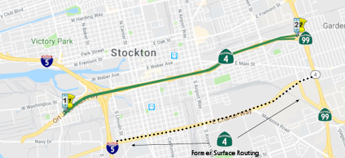 Route
Route  Route 3
 Route 5